
Day: May 24, 2015
Anglers invited to join citizen science effort
Watching the mouth of the Roaring Fork River — Aspen Journalism

From Aspen Journalism (Brent Gardner-Smith):
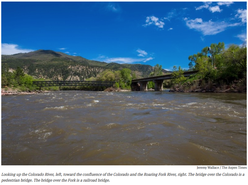
As my raft floated under the railroad bridge at the confluence of the Roaring Fork and Colorado rivers last week, I was wondering just how much water would flow out of the Fork and into the Colorado this year.
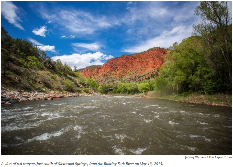
Certainly less than average, given that the snowpack peaked in March and began melting off, I mused, taking a stroke to catch the big eddy that forms just shy of the mighty Colorado, where the Fork comes in across from Two Rivers Park in Glenwood Springs after draining 1,543 square miles of land.
Perhaps the wet and cold weather of late April and much of May will continue to forestall a sudden flash of melting snow, so what snow we still have in the high country will come off in a nice steady fashion.
But spinning around the eddy, I knew how easy it was, as a boater, to be wrong about water and weather. It is also, as it turns out, a tricky time of year for professional hydrologists to predict run-off, as data from low-elevation snow-measuring sites tapers off and daily weather conditions can play a big role in shaping how much water flows, and when it does.
In mid-March, which felt like summer already, a trip on the Green River starting April 12 seemed like a good bet this year to enjoy some warm weather. But a big storm swept in that week and blasted the river with freezing rain.
The same storm laid down 11 inches of snow on Aspen Mountain by Friday, April 17, making for a memorable closing weekend for some.
After warming up from that trip, I ventured optimistically out again during the first full week of May, this time on the Colorado River west of Loma. And I was soon engulfed in the downpours of May 5 and 6 that lead to river levels across the region jumping up.
Between May 5 and May 7, for example, the flow in the lower Fork doubled from a 1,000 cubic feet per second to over 2,000 cfs.
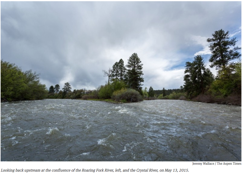
So when I went out on May 13 for my first trip of the season down the Roaring Fork from Carbondale to Glenwood, I wasn’t surprised that it started raining. It’s just been that kind of season so far — in fact, through May 19, total precipitation in the Roaring Fork River watershed was 204 percent, or double the normal amount of precipitation. according to the Natural Resource Conservation Service (NRCS).
But the Fork was flowing that day at 1,110 cubic feet per second, which was enough water to have a perfectly nice float, especially as I did see some sun (and some red-wing blackbirds).
But will the river get much bigger this year, I wondered as I rowed toward Glenwood.
Below average flows
The Colorado River Basin Forecast Center in Salt Lake City forecast on May 19 that the Roaring Fork will most likely peak this year in mid- to late June at 4,300 cfs, as measured at Veltus Park, just above the Fork’s confluence with the Colorado.
That’s 73 percent of the Fork’s average annual peak of 5,920 cfs, which typically occurs between May 29 and June 23.
While this year’s likely peak flow of 4,300 cfs is certainly better than the lowest peak flow on record — 1,870 cfs on June 3, 2012 — it’s also way below the historic peak of 11,800 cfs on July 13 in 1995.
The forecast peak flow has increased given the cool and wet weather in May. So, if April showers bring May flowers, May showers are likely to bring better boating on the Fork in June.
“I would say it is very likely (the Roaring Fork) will see a below average peak flow this year,” said Brenda Alcorn, a senior hydrologist with the Forecast Center.
However, she added that what snowpack we do have “is in better shape than it was in 2002 and 2012, so I do not expect a record low peak.”
But just how much water comes, and when, is now weather dependent.
“Spring temperatures and precipitation play a significant role in the pattern of snowmelt runoff and consequently the magnitude of peak flows,” Alcorn said. “An extended period of much above normal temperatures or heavy rainfall during the melt period can cause higher than expected peaks, while cool weather can cause lower than expected peaks.”
On Friday, May 15, Julie Malingowsky, a meteorologist with the National Weather Service in Grand Junction, said the period to at least May 25 looked cooler and wetter than normal, and longer-range forecasts indicate that the next several months could be wetter than normal.
(Also, see the Intermountain West Climate Dashboard of indicators at Western Water Assessment)
But probably not wet enough make up for the skinny snowpack.
“Even though it has been a wet month, we are still drier than normal,” Malingowsky said.
Below average supply
Another view of this year’s water picture is available from the Natural Resources Conservation Service’s “Colorado Water Supply Outlook Report,” which was published on May 1.
The report shows that the “most likely” amount of water to reach the bottom of the Roaring Fork between April and the end of July is 450,000 acre-feet, according to Brian Domonkos, a data collection officer with NRCS.
That’s below the 30-year average of 690,000 acre-feet flowing down the Fork for the period from April to August. (The Roaring Fork delivers, on average, 871,100 acre-feet of water to the Colorado River over a full year, according to the Colorado Division of Water Resources).
The water-supply report said that current conditions point to “a below normal streamflow forecast picture for much of the state heading into spring and summer of 2015.”
However, Gus Goodbody, a forecast hydrologist with NRCS, said the amount of water expected to flow out of the Roaring Fork is likely to increase from the May 1 forecast by five to 10 percent, given May’s weather so far.
“It’s going to go up,” he said.
Another indicator of potential run-off is the measure of the “snow water equivalent” at SNOTEL measuring sites in the Roaring Fork basin.
The average from the eight SNOTEL sites in the Roaring Fork basin was 108 percent on May 19, but that’s without complete data from four of the sites.
That number — 108 percent — has been climbing steadily since May 1, but it’s not an indicator that the snowpack has been growing. What it does show is that the cool and wet weather has slowed the run-off and moved the data closer to the historic average — which, again, bodes well for June boating. But in addition to the snowpack and the weather, there are other factors that dictate the flows in the Fork at Glenwood Springs.
Off the top
An average of 40,600 acre-feet of water a year is collected from the upper Roaring Fork River basin and sent through a tunnel under Independence Pass and into Twin Lakes Reservoir, destined for Aurora, Colorado Springs, Pueblo and Pueblo West.
The Twin Lakes diversion takes 40 percent of the water out of the upper Roaring Fork basin above Aspen, according to the 2012 Roaring Fork Watershed Plan.
Another 61,500 acre-feet is collected on average each year from tributaries of the upper Fryingpan River and sent east through the Bousted and Busk tunnels. That accounts for 37 percent of the water in the upper Fryingpan headwaters.
As such, there are many days when there are rivers heading both east and west out of the Roaring Fork River watershed, and the ones heading east can often be bigger.
For example, on May 13, while I was floating on 1,110 cfs at the bottom of the Fork, there was 136 cfs of water running under the Continental Divide in the Twin Lakes — Independence Pass Tunnel, which can, and does, divert up to 625 cfs later in the runoff season.
And the Bousted Tunnel, which transports the water collected from the headwaters of the Fryingpan River, as well as Hunter and Midway creeks in the Roaring Fork basin, was diverting 101 cfs on May 13.
Meanwhile, the gauge on Stillwater Drive on May 14 showed the main stem of the Fork was flowing, just east of Aspen, at 111 cfs.
Then there is the water diverted out of the rivers in the basin and into one of the many irrigation ditches along the Fork, the Crystal and other streams in the basin.
Ken Ransford, a member of the Colorado River Basin Roundtable, estimates that the 12 biggest irrigation ditches on the Roaring Fork and Crystal rivers divert about 115,000 acre-feet of water a year.
Most of that water eventually finds its way back to the rivers, but the diversions also leave many stream reaches lower than they otherwise would be, and few tributaries are left untouched.
According to the Roaring Fork Watershed Plan, “flow-altered stream reaches include the Roaring Fork, Fryingpan, and Crystal rivers, as well as Hunter, Lincoln, Maroon, Castle, West Willow, Woody, Snowmass, Capitol, Collins, Sopris, Nettie, Thompson, Cattle, Fourmile, and Threemile creeks.”
Another factor shaping the flows in the lower Fork are decisions made by regional water managers, including irrigators near Grand Junction and municipal water providers in Denver, that can shape releases from reservoirs such as Green Mountain and Ruedi.
Who needs water, and when, can also dictate the size of that eddy at the bottom of the Fork. So for now, I’m just glad it’s big enough to float a boat.
Editor’s note: Aspen Journalism is collaborating with The Aspen Times, the Aspen Times Weekly, and The Glenwood Springs Post Independent on coverage of rivers and water. The Aspen Times Weekly published this story on Thursday, May 21, 2015.
More Roaring Fork River watershed coverage here.
Colorado: Big flows expected in Blue River
“This May has really been a miracle in Colorado” — Eric Kuhn #ColoradoRiver

From The Grand Junction Daily Seninel (Gary Harmon):
“This May has really been a miracle in Colorado,” said Eric Kuhn, general manager of the Colorado River Water Conservation District, Thursday at the Mesa County State of the Rivers discussion at the Avalon Theatre in Grand Junction.
Lake Powell could see 1 million to 1.5 million acre-feet of water flow in, Kuhn said, as a result of the storm system that has dropped sometimes heavy rains in the valleys of western Colorado and topped the peaks with fresh snow.
As of Thursday, Lake Powell was at an elevation of 3,593 feet, or about 100 feet above the level at which it can generate power. That 100 feet equates to approximately 7.8 million acre-feet of usable storage, according to the U.S. Bureau of Reclamation.
Though snowpack was below average last winter, reservoirs that feed the Colorado River in Colorado are expected to fill, said Ryan Christianson, water-management group chief for the Grand Junction Bureau of Reclamation office, to about 100 people attending the meeting sponsored by the River District and the Colorado Mesa University Water Center.
Officials, however, are watching to see if they will have to boost flows from upper-basin reservoirs to mimic spring runoff levels that are important to the four endangered fish of the Colorado River, Christianson said.
Managers were able to save about 22,000 acre-feet in Blue Mesa Reservoir by holding back some water as flows rose in the North Fork of the Gunnison River, Christianson said.
More Colorado River Basin coverage here.
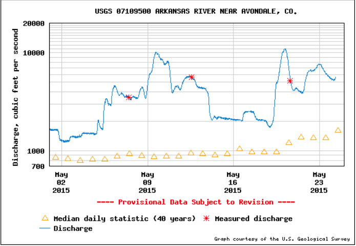
Arkansas River continues to run high — The Pueblo Chieftain
From The Pueblo Chieftain (Chris Woodka):
Flood stage is considered 6,000 cubic feet per second, or the effect of 6,000 basketballs tumbling past any given point at the same time.
Releases from Pueblo Dam are cut during floods and the water stored, then released as soon as practically possible. During rains earlier this month about 4,000 acre-feet (1.3 billion gallons) was stored, then released. In last week’s storms, 12,000 acre-feet was stored and was being released Thursday.
Those releases were cut back slightly Friday as Avondale pushed above 6,000 cfs again.
The Arkansas River through Pueblo and Fountain Creek were contributing evenly to the flow, about 3,000 cfs each.
Upstream of Lake Pueblo, flows at Wellsville, just east of Salida, have not reached normal levels for this time of year, because cooler temperatures are delaying runoff.
But heavy rains in Fremont County have swollen gauges there for the past two weeks.
The Huerfano and Purgatoire rivers east of Pueblo have been running well above average for the last week.
Downstream of Pueblo, the Arkansas River continues to run high, as most large irrigation canals are not taking water. At Las Animas, the river measured close to 5,000 cfs Saturday.
Southeastern Water board meeting recap: Lake Pueblo, swollen by 12,000 acre-feet of flood water

From The Pueblo Chieftain (Chris Woodka):
Water, water everywhere.
Not going to be a problem later in the year, right?
Hold on.
The Southeastern Colorado Water Conservancy District Thursday considered the possibilities of how water comes through the Boustead Tunnel into Turquoise Lake under the Fryingpan- Arkansas Project.
All signs are pointing toward a more-or-less normal year in terms of water supply. Lake Pueblo, swollen by 12,000 acre-feet of flood water, is 132 percent of average. The flood water already was being released on Thursday, raising Arkansas River levels in the wake of the flood surge.
Turquoise and Twin Lakes are above average in the upper reaches of the Arkansas River, while John Martin Reservoir has begun filling again to its highest level since 2010, about 82,000 acre-feet on Thursday.
Snowpack levels in the headwaters of both the Colorado and Arkansas Rivers are back to normal, but it’s late in the season and both basins fell short of peak moisture levels this year.
But very little transmountain water has come over so far, just 4,254 acre-feet of a projected 53,000 acre-feet for the season.
“It all depends on how it comes off,” said Roy Vaughan, Fry-Ark manager for the Bureau of Reclamation.
Cold temperatures are preventing the snow from melting at prime rates, as it does at this time of year in some cases.
“The tunnel hasn’t started to run at full capacity, so we’re behind,” Vaughan said.
If it warms up too quickly, the Fry-Ark structures won’t be able to capture it. And river levels have to be met on the Western Slope, Vaughan explained.
In the past decade, the Southeastern district has adopted new policies to avoid over-allocating water early in the season, so it holds back 20 percent of the allocation.
More coverage from Chris Woodka writing for The Pueblo Chieftain:
Farms will get a boost in water supply, with nearly average allocations from the Fryingpan- Arkansas Project, but reduced requests from cities for water.
The Southeastern Colorado Water Conservancy District Thursday approved allocations from the project, based on snow forecasts, which have improved since projections of water supply were made May 1.
The district projects that 53,000 acre-feet (17 billion gallons) of water will be brought through the Boustead Tunnel into Turquoise Lake. That would mean almost 45,700 acre-feet available for allocation.
Of that, about one-third will go to cities and two-thirds to farms. Under the district’s allocation principles, the split would be closer to 53 percent municipal and 47 percent agricultural.
Initially, just 80 percent of the water will be allocated in case conditions change and imports are less than expected. The remaining 20 percent will be available when imports reach the target.
If more water above the target is brought over, there could be a second allocation.
Cost of the water is $9 per acre-foot for farms and $9.75 for cities.
Municipalities reduced their requests significantly this year.
The Fountain Valley Authority (Colorado Springs, Fountain, Security, Stratmoor Hills and Widefield) requested and received 7,216 acrefeet, but was eligible for 11,625 acre-feet.
The Pueblo Board of Water Works was eligible for 4,568 acrefeet, but requested and received no water, since Pueblo Water has ample water in storage this year.
Cities east of Pueblo took slightly less water than authorized, mainly because St. Charles Mesa Water District took just one-sixth of its share. Fowler, Crowley County and Joseph Water all took significantly more water than authorized, while most others were close to average.
Cities west of Pueblo took slightly more. All received the full amount requested.
Pueblo West and Manitou Springs, which get water that was redirected from agriculture when Crowley County farms were dried up by Aurora, will each get full allocations of about 155 and 160 acre-feet, respectively.
The net effect was moving about 9,000 acre-feet to the agricultural side of the ledger, said Garrett Markus, district engineer.
On the agricultural side, Fort Lyon Canal will received the largest allocation, with 10,653 acre-feet, and it will use 3,135 acre-feet of return flows under a pilot project that allows the ditch to use its own return flows for replacement water under state irrigation rules. Only 58,618 acres of the ditch are eligible for Fry-Ark water. The ditch irrigates 93,000 acres, but owners with more than 960 acres, including Pure Cycle (which has 14,600 acres) are not eligible.
As usual, requests for ag water far outpaced the available water.
Farmers asked for 106,570 acre-feet to cover 146,000 acres on 25 canals, ditches or farms. Only 30,024 acrefeet were allocated.
Another 7,431 acre-feet of agricultural return flows were allocated, 95 percent to the three major well augmentation groups in the Arkansas Valley.
More Fryingpan-Arkansas Project coverage here.