The PHS has reduced the optimum recommended amount of fluoride in municipal water systems to a maximum of 0.7 milligrams per liter. The previous recommended range, from 0.7 to 1.2 milligrams, was changed this year for the first time since 1962.
Fluoride levels in Granby’s water supply vary depending on whether the water comes from the North Service Area or the South Service Area, two separate water systems providing public water service to community residents. Historically the fluoride levels in the two different service areas have been 1.1 milligrams per liter.
Following the new recommendations the North Service Area began reducing the amount of fluoride added to the water system. Granby Town Manager Wally Baird explained the levels in the North Service Area are already down to 0.9 milligrams per liter, and the Town plans to continue to reduce North Service Area down to the recommended level of 0.7 milligrams.
The South Service Area’s fluoride levels will remain at 1.1 milligrams per liter. No fluoride is added to the water in the South Service Area, explained Superintendent of the South Service Area Doug Bellatty. Instead the water levels in the South Service Area are naturally occurring.
Bellatty explained why the fluoride levels in the South Service Area will remain the same.
“The only process available to communities to lower the naturally occurring levels is through reverse osmosis,” he said, “which is extremely expensive and energy consuming.”
Bellatty pointed out that while the recommendation levels have been dropped, the Maximum Contaminant Level (MCL) — the highest level of a contaminant allowed in drinking water — for fluoride is 4 milligrams per liter.
FromThe Colorado Springs Gazette (Ryan Maye Handy):
…some incorrectly installed sump pumps in the Pleasant Valley neighborhood, around Colorado Avenue and 31 Street, have caused Colorado Springs Utilities’ wastewater lines to overflow with groundwater.
Utilities crews have worked for the last two weeks to remove some water from overloaded wastewater systems before the contaminated water overflows manholes and rushes into the street, said Utilities spokesman Steve Berry.
Pumps hooked up directly to the wastewater system are a problem for Utilities and homeowners.
“The number one risk is really for the customer,” Berry said Tuesday. “If the sump pump is hooked up to the wastewater system … then the biggest threat is really to your home.”
If excess groundwater gets pushed into the wastewater system, it could backfire and send water back into a home or a neighboring home, Berry said…
Sump pumps are supposed to discharge excess groundwater outside a home, typically through a pipe that dumps into a yard. But, particularly in older neighborhoods such as Pleasant Valley, sometimes the pumps are connected directly to a home’s wastewater line, which connects to Utilities’ wastewater main.
Homeowners own their wastewater lines and are responsible for maintaining them, and if damage on the private line affects the main Utilities line, homeowners could be liable, Berry said. He said homeowners should make sure pumps are correctly installed, although most will likely have to hire someone to check the system.
“These folks don’t even know, and it’s certainly not their fault, but now they need to,” Berry said.
Arkansas River Basin High/Low graph May 21, 2015 via the NRCS
Upper Colorado River Basin High/Low graph May 21, 2015 via the NRCS
Gunnison River Basin High/Low graph May 21, 2015 via the NRCS
Laramie and North Platte Basin High/Low graph May 21, 2015 via the NRCS
Upper Rio Grande River Basin High/Low graph May 21, 2015 via the NRCS
San Miguel, Dolores, Animas, and San Juan Basin High/Low graph May 21, 2015 via the NRCS
South Platte River Basin High/Low graph May 21, 2015 via the NRCS
Yampa and White Basin High/Low graph May 21, 2015 via the NRCS
Check out the Basin High/Low graph for your favorite basin to see how much snow water equivalent is left. There will be a new streamflow forecast for Colorado released week after next. Below is the streamflow forecast from May 1.
May 1, 2015 Colorado streamflow forecast map via the NRCS
Click here to read the newsletter. Here’s an excerpt:
Northern Water’s Katie Melander is the new president of the Colorado section of the American Water Resources Association. Katie is a water resources engineer. The gavel was turned over to Katie during the AWRA Colorado Section (@awraco) symposium May 1. An objective of the AWRA Colorado section is to promote the advancement of water resources research, planning, development, management and education.
More Northern Colorado Water Conservancy District coverage here.
Five nonprofit organizations are partnering to host Poudre RiverFest, a community festival, from 9 a.m. to 6 p.m. on May 30 at Legacy Park in Fort Collins. Admission is free.
Save the Poudre, Sustainable Living Association, Rocky Mountain Bird Observatory, Synergy Ecological Restoration and Fort Collins Museum of Discovery are co-organizing the festival to restore, celebrate and educate people about the Cache la Poudre River, a significant natural resource in our community.
Poudre RiverFest will feature a variety of activities for people to explore the role of the river as an important habitat for wildlife, a recreation area and a source for clean drinking water. Educational and volunteer activities will take place throughout the day with a culminating celebration in the afternoon.
At this family-friendly festival, people can experience scientific research at a bird banding station, go on nature walks to learn about the Poudre River and its inhabitants, volunteer to enhance wildlife habitat through hands-on service projects, and learn about conserving the river through a photo scavenger hunt. In the afternoon, they can kick up their heels to live music from 12 Cents for Marvin, The Burroughs and Justin Roth, connect with local conservation organizations and enjoy kids’ activities, food, a beer garden and more.
This is the second year of this current iteration of Poudre RiverFest. In May of 2014, like-minded nonprofits launched the festival in the wake of the high floodwaters of 2013. More than 1,000 people attended the festival to learn about, restore and celebrate the Cache la Poudre River last year.
All proceeds from the festival support conservation and education nonprofits in Fort Collins.
People are encouraged to get involved! Volunteers are needed to help with hands-on service projects and the festival itself. To volunteer or view the festival schedule, visit http://www.poudreriverfest.org
More Cache la Poudre River watershed coverage here.
Thousands who commented on Colorado’s draft water plan will be surprised to learn that their letters, postcards and emails may be discounted by at least one of the 15 water bosses working on the issue.
The water plan has been hailed by Gov. John Hickenlooper as an unprecedented grassroots effort to end the state’s long-running water feuds and to avoid a looming water crisis. The plan will determine if Front Range cities with booming populations will suck up more water for growth, threatening farms on the eastern plains and mountain streams.
The Colorado Water Conservation Board asked for everybody’s input – from farmers and ranchers, to city-dwellers, CEOs, water companies, kayakers and anglers. But everybody’s voice won’t hold equal weight. The question the board is discussing is whose voices should count and how much should each perspective matter?
“I am not moved by the form letters. I’m much more interested in the thoughtful comments from individuals,” said Travis Smith, representing the Rio Grande River Basin at the CWCB’s May 20 board meeting in Sterling.
Smith was referring to over 22,000 comments generated by groups like Conservation Colorado that sent out action alerts to members, asking them to weigh in on the plan’s first draft.
Many of those form letters featured John Fielder photos of mountain streams and short, often passionate personal notes about how the plan should conserve Colorado water for fishing, farming and play.
Smith, speaking for farmers and ranchers, said quantity of comments shouldn’t outweigh quality. It’s not a majority-wins process.
“I don’t sign form letters. The ag community in general will show up at the first few meetings and say their piece. Then they go back to work, confident that the entity will carry the weight of those comments,” Smith said.
In all, the draft-plan garnered about 24,000 comments. Approximately 22,906 of those were classified as form letters.
Board members questioned how to judge the relative weight of the different comments, but nobody other than Smith suggested that the form letters shouldn’t count.
A majority of the public wants Colorado to conserve water for the recreation industry and agriculture. But not everybody agrees how water should be used, and the diversity of opinions challenge planners balancing competing and growing demands for water from cities, farms and wilderness.
The comments will be used to shape the second draft of the water plan, due July 15. That draft will recommend ways to divvy up water over the next few decades. It will likely recommend that new laws and regulations get passed – some of which might have a hefty price-tag.
The comments have already spurred “real changes” to the second draft. CWCB will rewrite the section on finding money to help pay for water projects, study which streams may need more environmental protection and add more information on climate change.
“The data show the environment is an important part of Colorado’s water plan, but we need more input from the ag community,” he said. “The environmental groups participated in this process in a big way,” said CWCB director Jim Eklund. “But just because we didn’t hear from the ag community doesn’t mean that’s not an equally important value,” he said.
The most important thing is to mine the comments for really good ideas, nuggets that will help the state move the needle on water issues, Eklund said.
It appears Colorado could cut water use by 30 percent in the next 35 years with simple conservation measures taken by industry, agriculture and individuals, said CWCB staffer Becky Mitchell.
The challenge is finding ways to make that happen – which includes convincing lawmakers to make funds available for water-saving measures, said CWCB director Russ George.
Once planning is done, he said, the hard political work will begin.
This summer, more than 20 NOAA scientists will stay up late to learn why some thunderstorms form and grow at night, without the energy from the sun’s heat. They will be participating in the Plains Elevated Convection At Night (PECAN), a large, intensive field campaign to collect data before and during nighttime thunderstorms in the western Great Plains from June 1 to July 15.
PECAN researchers will deploy instrumented aircraft, ground-based instruments, mobile radars, and weather balloons to learn what triggers these storms, how the atmosphere supports their lifecycle, and how they impact lives, property, agriculture and the water budget in the region. Meteorologists believe these targeted observations will build understanding and ultimately improve forecasts of these sometimes damaging storms.
“Large nighttime thunderstorms are an essential source of summer rain for crops, but also produce widespread and potentially hazardous severe weather, excessive rainfall, flash flooding, and unusually frequent cloud-to-ground lightning,” said Conrad Ziegler, a research meteorologist at the NOAA National Severe Storms Laboratory and principal scientist for PECAN. “Weather forecast models often struggle to accurately account for these. The PECAN field campaign will provide us with valuable insights—and improve our ability to save lives and property through more accurate forecasts.”
The PECAN field campaign will involve scientists, students, and support staff from eight research laboratories and 14 universities. The $13.5 million project is largely funded by the National Science Foundation (NSF), which contributed $10.6 million. Additional support is provided by NOAA, NASA, and the U.S. Department of Energy.
Nighttime storm triggers
Once the sun goes down, the Earth and its lower atmosphere usually loses heat and becomes more stable, an environment not so favorable for supporting thunderstorms. In the Great Plains, however, many summer storms form after sunset, and sometimes without an obvious trigger.
PECAN scientists are interested in large complexes of thunderstorms called Mesoscale Convective Systems that can grow overnight, last for hours and often produce severe and hazardous weather. They will investigate how a low-level river of air triggers thunderstorms and supports storm evolution, what causes storms to grow into MCSs, and how MCSs respond to the surrounding environment.
In addition, PECAN researchers will test their hypotheses about how deep waves in the atmosphere form and ripple across the plains, like what happens with water when a stone is thrown in a pond, causing new storms to form after sunset. One type of atmospheric ripple is called a “bore.” Thunderstorms can create bores, but bores can also cause a thunderstorm to suddenly intensify. PECAN is the first modern campaign to study the role of bores and how they trigger and support Mesoscale Convective Systems.
Armada of instruments
More than 20 NOAA researchers and students will be responsible for gathering data with multiple instruments including the NOAA-X-Pol, a dual-pol mobile radar, two mobile balloon launch vehicles, and two “mobile mesonet” vehicles equipped with weather instruments. New to the fleet is the Collaborative Lower Atmosphere Mobile Profiling System (CLAMPS) designed by NSSL researchers to meet many of NOAA’s and its National Weather Service’s needs for lower atmosphere temperature, humidity and wind profiles. Additionally, one of the three aircraft participating in PECAN will be a NOAA Lockheed WP-3D Orion aircraft, best known for its hurricane hunting missions.
Unique to the experiment is an observation strategy that uses PECAN Integrated Sounding Array (PISA) stations to provide temperature, humidity, and wind profiles about every five minutes. The Department of Energy will provide six out of the eight ground-based upward-looking infrared spectrometer instruments. Dave Turner, NSSL scientist and PECAN steering committee member, will coordinate their operation.
Deploying in the dark
Fort Hays via kansapedia
The campaign is based in Hays, Kansas, and will begin each day at 8 a.m. CDT. A team of meteorologists, including retired forecasters from NOAA’s Storm Prediction Center, will work on a forecast for the upcoming night. At 3 p.m., scientists will use the forecast to determine where across northern Oklahoma, central Kansas, or south-central Nebraska to deploy their mobile resources. Teams will then ferry the instruments to the target area, set up, and collect data from dusk until after midnight. When the observation period is complete, they will ferry the instruments back to the base in Hays. A better understanding of these storms will have relevance for areas beyond the Great Plains, because clustered nighttime thunderstorms are common in various regions scattered across the globe.
A high desert thunderstorm lights up the sky behind Glen Canyon Dam — Photo USBR
Precipitation Outlook May 21 thru August 31, 2015 via the Climate Prediction CenterTemperature Outlook May 21 thru August 31, 2015 via the Climate Prediction Center
Colorado transmountain diversions via the State Engineer’s office
Click through to listen to an interview with Jim Pokrandt from Aspen Public Radio (Marci Krinoven). Here’s an excerpt:
The commissioners are organizing a meeting of Western Slope elected leaders to draw up a unified message ahead of the completion of Governor Hickenlooper’s statewide water plan. Garfield County Commissioner Tom Jankovsky:
“You take Pitkin County and Garfield County – they’re miles apart philosophically on how things should be done. But, when it comes to transmountain diversions, we have the same mindset: no more water to go to the east slope.”
Seven-point draft conceptual agreement framework for negotiations on a future transmountain diversion screen shot December 18, 2014 via Aspen Journalism
Some water officials in the state have endorsed what’s called the “7 points of consensus.” It includes consideration of new transmountain diversions that would move Western Slope water east. Already, 13 major diversions move water through the mountains.
Click here to go to the US Drought Monitor website. Here’s an excerpt:
Summary
Nearly coast-to-coast storminess reduced drought’s footprint across the nation’s mid-section but triggered lowland flooding from the southeastern Plains and the western Gulf Coast region into the mid-South. Farther east, however, only light showers, if any, dampened the eastern U.S., except for some briefly heavy rain in the northern Mid-Atlantic region. In the Northeast, where little precipitation has fallen during the spring, another mostly dry week raised concerns about a lack of soil moisture and declining streamflows. Meanwhile, cool, wet weather in the upper Midwest provided much-needed moisture, following a period of rapid planting progress. In fact, below-normal temperatures dominated much of the country, with widespread freezes noted across the north-central U.S. from May 18-20. Elsewhere, broadly unsettled weather prevailed in the West, with the heaviest precipitation falling across the northern Intermountain region and the central and southern Rockies. The Western precipitation boosted topsoil moisture, aided winter grains, and reduced irrigation requirements. Beneficial showers dampened parts of California and Nevada, but failed to dent the Far West’s serious hydrological drought…
Great Plains
Frenetic weather led to further reductions in drought coverage. Late-season snow briefly blanketed several areas, including parts of North Dakota on May 17-18 and western Nebraska on May 19-20. Farther south, multiple rounds of heavy showers and locally severe thunderstorms led to flooding, particularly across the southeastern Plains. Several gauging points, including the Red River near DeKalb, Texas, and the Poteau River near Panama, Oklahoma, climbed to their highest levels since May 1990. The Red River near DeKalb rose 4.51 feet above flood stage on May 13, while the Poteau River near Panama surged 14.54 feet above flood stage on May 12. By May 20, cumulative storage in Texas’ reservoirs climbed to 24.78 million acre-feet (78.5% of capacity)—the highest in more than 4 years. Only a month ago, Texas’ storage was 22.53 million acre-feet, or 71.4% of capacity. Six months ago, on November 20, 2014, storage stood at just 19.43 million acre-feet, 62.0% of capacity.
On the southern Plains, month-to-date rainfall has already exceeded a foot in many locations, including Oklahoma City, Oklahoma (13.88 inches, or 508% of normal), and Wichita Falls, Texas (12.43 inches, or 570%). Record-high May totals in those two locations are 14.52 inches (in 2013) in Oklahoma City and 13.22 inches (in 1982) in Wichita Falls. In the Plains’ cotton belt, incessant rains have hampered fieldwork. For example, only 19% of Texas’ intended cotton acreage had been planted by May 17, compared to the 5-year average of 36%.
Farther north, spring precipitation arrived mostly too late to revive winter wheat but has aided rangeland, pastures, and summer crops. By May 17, roughly one-third of the winter wheat was rated in very poor to poor condition in South Dakota (36%), Nebraska (31%), and Kansas (30%). The damage to wheat was caused much earlier due to a combination of drought and winter weather extremes. Meanwhile, South Dakota’s rangeland and pastures—which were rated 33% very poor to poor on May 3, improved to 24% very poor to poor by May 17. Spring wheat, grown primarily in six Northern States from Washington to Minnesota, was off to a good start, with 65% of the crop rated good to excellent (and only 4% very poor to poor) on May 17…
West
Cool, occasionally showery weather across much of the western U.S. reduced irrigation demands, boosted topsoil moisture, and benefited rangeland, pastures, winter grains, and spring-sown crops. However, the late-season moisture failed to significantly alter the bleak hydrological situation in drought-affected areas, including California. By April 30, reservoir storage as a percent of average for the date was significantly below normal in Arizona, California, Nevada, New Mexico, and Oregon. Storage in California’s 154 reservoirs stood at 18.0 million acre-feet (64 percent of average) on May 1, about 1.6 million acre-feet lower than a year ago. With little snow in the mountains above California’s lakes, further inflow will be negligible, meaning that the reservoir recharge season has ended early.
An exception to the West’s cool, damp pattern was the Pacific Northwest, where abnormal dryness (D0) expanded to cover western Washington. During the first 19 days of May, rainfall totaled just 0.65 inch (20% of normal) in Quillayute, Washington. Farther inland, USDA on May 17 rated only a little more than one-third of the winter wheat crop in good to excellent in Washington (39%) and Oregon (34%). In addition to less-than-ideal crop conditions, snowpack and streamflows remain at extremely low levels in most of the Northwest. As a result, severe drought (D2) was introduced across portions of northeastern Washington and northern Idaho, while moderate drought (D1) was expanded. Farther south, recent precipitation has been heavy enough in southern Idaho to prevent significant drought expansion, although hydrological concerns persist.
Despite atypically heavy showers for May in California, Nevada, and Arizona, the drought depiction remained effectively unchanged. Simply stated, the late-season rain and snow showers have improved the appearance of the landscape but have left the underlying, long-term drought virtually untouched. Even with the showers, California’s topsoil moisture was rated 85% very short to short on May 17, while subsoil moisture was 90% very short to short. Similarly, Nevada’s topsoil moisture was 65% very short to short, while subsoil moisture was 85% very short to short. Nevertheless, locations reporting their wettest May day on record included San Diego, California (1.63 inches on May 14; previously, 1.49 inches on May 8, 1977), and Phoenix, Arizona (0.93 inch on May 15; previously, 0.91 inch on May 4, 1976).
More widespread precipitation has fallen in recent weeks across the central and southern Rockies and environs. In fact, the water content of the high-elevation snowpack climbed above the mid-May average in several river basins in the Rockies of Colorado and New Mexico. Due to the extensive precipitation, improved water-supply prospects, and boost in soil moisture, another round of sweeping improvements in the drought depiction were introduced in Colorado and New Mexico, extending northward into southern Wyoming and westward into eastern Utah. Through May 19, month-to-date precipitation has totaled 200 to 300% of normal in locations such as Grand Junction, Colorado; Salt Lake City, Utah; Denver, Colorado; and Evanston, Wyoming. Parts of New Mexico have been even wetter in recent weeks, relative to normal, with May 1-19 totals reaching 5.45 inches (524% of normal) in Clayton and 1.50 inches (484%) in Albuquerque…
Looking Ahead
During the next several days, a parade of storms will continue to emerge from the western U.S. As a result, 5-day precipitation totals could reach 1 to 2 inches from Oregon and northern California to the Intermountain West. Meanwhile, totals of 2 to 5 inches or more can be expected across the central and southern Plains and parts of the mid-South. In contrast, little or no rain will fall in the eastern U.S. and across the nation’s northern tier. Most of the country, excluding the Southeast and Northwest, will continue to experience cool weather.
The NWS 6- to 10-day outlook for May 26 – 30 calls for likelihood of above-normal temperatures along the Pacific Coast, in the Northwest, and east of the Mississippi River. Meanwhile, cooler-than-normal conditions will cover the central and southern High Plains and parts of the Southwest. A wet pattern will persist nearly nationwide, with drier-than-normal weather likely limited to the northern Pacific Coast, southern Florida, and a small area near the Canadian border centered on northern North Dakota.
From the Department of Interior (Jessica Kershaw/Peter Soeth/Albert Rodriguez/Tonya Durrell):
As part of the Obama Administration’s continued effort to bring relief to western communities suffering from the historic drought, U.S. Secretary of the Interior Sally Jewell today announced that Interior’s Bureau of Reclamation will invest nearly $50 million to improve water efficiency and conservation in California and 11 other western states.
“In a time of exceptional drought, it is absolutely critical that states and the federal government leverage our funding resources so that we can make each drop count,” said Secretary Jewell. “Being ‘water smart’ means working together to fund sustainable water initiatives that use the best available science to improve water conservation and help water resource managers identify strategies to narrow the gap between supply and demand.”
Joined by Nancy Sutley, Chief Sustainability and Economic Development Officer of the Los Angeles Department of Water and Power, the funding announcement was made today at the Donald C. Tillman Water Reclamation Plant in Van Nuys, CA, where millions of gallons of wastewater are purified each day. Secretary Jewell, Bureau of Reclamation Commissioner Estevan López and Sutley emphasized the importance of federal-state partnerships to help work toward a more sustainable and resilient water future.
“Through the WaterSMART Program, Reclamation is providing funding for water conservation improvements and water reuse projects across the West,” Reclamation Commissioner Estevan López said. “We commend the state of California for all the steps they have already taken to alleviate the impacts of the drought. We hope this federal funding for water reuse and efficiency will help us leverage scarce resources between the state and federal governments to bring much-needed relief for the people and environment of California.”
“The federal government’s support for critical water efficiency and reuse projects is most valuable especially during this historic drought in California,” said Sutley. “The investments will help cities like Los Angeles carry out our sustainability objectives, further build our local water supply and reduce our reliance on imported water. We look forward to all these important opportunities ahead of us.”
“We are honored to host Secretary Jewell at our Donald C. Tillman Water Reclamation Plant and Japanese Garden today,” said LA Sanitation Director Enrique C. Zaldivar, P.E. “We look forward to learning more about the environmental partnership opportunities she will announce during her visit.”
Reclamation is investing more than $24 million in grants for 50 water and energy efficiency projects in 12 western states, more than $23 million for seven water reclamation and reuse projects in California, and nearly $2 million for seven water reclamation and reuse feasibility studies in California and Texas.
WaterSMART is the U.S. Department of the Interior’s sustainable water initiative. Since it was established in 2010, WaterSMART has provided about $250 million in competitively-awarded funding to non-federal partners, including tribes, water districts, municipalities and universities. These investments have conserved enough water to meet the needs of more than 3.8 million people. Every acre-foot of conserved water delivered means that an equivalent amount of existing supplies is available for other uses.
WaterSMART water and energy efficiency grants can be used for projects that conserve and use water more efficiently, increase the use of renewable energy, improve energy efficiency, benefit endangered and threatened species, facilitate water markets, carry out activities to address climate-related impacts on water or prevent any water-related crisis or conflict. The 50 projects announced today will be leveraged with at least 50 percent non-federal funding for a total of $133 million in improvements over the next two to three years. For a complete description of the 50 projects, please visit the WaterSMART Water and Energy Efficiency Grant website.
Through Title XVI of the Reclamation Wastewater and Groundwater Study and Facilities Act, Reclamation provides funding for projects that reclaim and reuse municipal, industrial, domestic or agricultural wastewater and naturally impaired ground or surface waters. Title XVI provides up to 25 percent of project costs. Project sponsors provide the remaining 75 percent of the funding necessary to carry out projects, thereby leveraging limited federal funding to implement as many water reuse projects as possible. Seven projects in California will receive $23.2 million. For a complete description of these seven water reuse projects, please visit the WaterSMART Title XVI website.
Also under the Title XVI Act, Reclamation is providing $1.6 million for communities to study whether water reuse projects would help them to meet their future water needs. Four feasibility studies in California and three studies in Texas were selected this year. Feasibility studies are funded jointly by Reclamation and project sponsors. A cost-share of at least 50 percent of study is required. For a complete description of the seven new studies selected for funding, please visit the WaterSMART Title XVI website.
Water from this week’s rainfall is flowing into storage now, as farmers wait out the wet spell to get back into fields.
“What we need now is for it to quit raining and warm up,” said Rocky Ford farmer John Schweizer. “We’re happy for the rain, but it’s so wet we can’t do anything.”
Most canals were shut off during this week’s rains, and flows from Lake Pueblo were cut as the Arkansas River reached flood stage at Avondale. Flows at Avondale topped 10,000 cubic feet per second overnight Wednesday, more than 4,000 cfs above flood stage. Avondale remained above 6,000 cfs for most of the day Wednesday.
For farmers, there is still a lot of planting to do, particularly corn, which is grown for feed and a major cash crop in the Arkansas Valley.
“We got most of our stuff planted when it should be planted,” said Joe Mauro, who farms on the Bessemer Ditch in Pueblo County. “We put the corn and chiles in before this rain, and they’ll do well if the crust from this moisture isn’t too thick. We will put in pinto beans and pumpkins by June.”
In other parts of the valley, most crops are delayed.
“The stuff planted earlier hasn’t gotten up yet, and corn planting is delayed,” said Mike Bartolo, of the Colorado State University Research Center at Rocky Ford. “There was a window to get stuff in last weekend, but most of it should be planted. It’s a mixed bag, but it’s generally delayed.”
Even alfalfa — plants that winter over — has been problematic, Schweizer said.
Warm weather this year got it started early if it hadn’t been knocked back by dry, cold weather over the winter. But that brought out bugs, too. Farmers who have already sprayed for bugs have to spray again once temperatures warm up.
Because corn prices have dropped, some farmers in the Lamar area are planting milo, or sorghum, and even soybeans, crops that use less water and have a longer planting window, said Dale Mauch, who farms near Lamar.
“We’ve been dry for so long. Everything changed after May 1,” Mauch said. “This is the first time in a long time that you’ll be able to plant all your acres on all your land. It’s sure nice to see green country.”
Grasslands also are coming back, so those who nursed their cattle herds through the drought should be in good shape. Because of the shortage of cows, it will be expensive to rebuild herds that were culled, however.
The Colorado Canal, which is mostly owned by Colorado Springs and Aurora, and the Fort Lyon Canal were the only large ditches taking water Wednesday, because they can store it. Colorado Springs and Aurora were releasing water from Lake Meredith and leasing it to the Lower Arkansas Water Management Association and Colorado Parks and Wildlife, Division 2 Engineer Steve Witte said.
Combined, the ditches took about 1,280 cfs of water.
The rest is being stored in John Martin Reservoir under conservation storage, or in the Amity Canal account in lieu of flowing into the Great Plains reservoirs via the Fort Lyon storage canal. John Martin storage has increased from about 6,300 acrefeet in November to 80,000 acre-feet. Water in conservation storage is used for later release in Colorado and to satisfy Kansas demands for water at the state line, so any water stored by Colorado farmers carries a 35 percent surcharge.
Witte couldn’t say how much water will be contributed to John Martin during this event, since there were delayed flows yet to come from the Purgatoire and Huerfano Rivers, as well as Fountain Creek. More rainfall is expected through the weekend throughout the area.
John Martin Reservoir back in the day
FromThe Pueblo Chieftain (Tracy Harmon/Matt Hildner):
Water levels at the reservoir have risen significantly, leading to changes that will impact guests and those planning on visiting in the near future. According to Colorado Parks and Wildlife spokeswoman Abbie Walls, most areas on the south side of the reservoir are under water, so areas where trailers can be parked will be limited…
John Martin Reservoir gained almost 27,000 acre feet of water in the past week due to storms. As of Monday, the reservoir had 77,600 acre feet of water and was still rising, compared to about 31,000 acre feet and dropping last year at this time.
…with a historic drought hitting California and much of the Southwest, parts of the river have reached their driest points in hundreds of years.
And this increased demand on the river is causing Wyoming, along with the other western states, to take notice.
“Anything that puts more pressure on the Colorado River should be a concern for all the states, including Wyoming,” said Douglas Kenney, who heads the Western Water Policy Program at the University of Colorado-Boulder. “There is only so much water to go around.”
Wyoming’s water managers say the Cowboy State hasn’t been directly affected by the water shortage in the downstream states.
This is because a nearly 100-year-old interstate compact ensures Wyoming can use a predetermined amount of the water that flows through its borders.
“Anytime a drought occurs in our country, it is worth watching,” said Harry LaBonde, director of the Wyoming Water Development Commission. “But if you are asking if California is going to demand more water from Wyoming, the answer is no.”
LaBonde and other state officials say the western drought, and the threat that the situation could worsen, is still enough of a concern that Wyoming should see the situation as a warning and take steps to safeguard its own water supplies.
This is partly what prompted Gov. Matt Mead to include a plan in his recently announced statewide water strategy to build 10 reservoirs in 10 years.
Nephi Cole, a policy adviser to the governor, said it’s important for the state to begin planning these projects, which can take years and millions of dollars to complete, so Wyoming isn’t caught off guard in the future.
“The challenge is many times when you need a water project and you realize you are in a really dry year, it is already too late,” he said…
Wyoming and the “Law of the River”
Unlike much of southeast Wyoming, several western parts of the state don’t have the luxury of being able to rely on plentiful groundwater resources.
That means many municipal water systems, agricultural users and other industries largely depend on the Green River, which is the main tributary of the Colorado River, to meet their needs.
The 730-mile waterway begins in the Wind River Range of Sublette County and travels south into Utah before it connects with the Colorado River.
In total, a drop of water that starts in Wyoming could travel through Colorado, Utah, Arizona, New Mexico, Nevada and California.
So, who owns that droplet of water?
That hotly contentious question was largely answered by a 1922 interstate deal known formally as the Colorado River Compact. This, combined with a complex series of other compacts, federal laws, court decisions and decrees, make up what is colloquially referred to as “The Law of the River.”[…]
It goes on to say that Wyoming is allowed to use 14 percent of the 7.5 million acre-feet of the upper-basin states’ allocation. That amount is equal to more than 342 billion gallons – or the equivalent of 517,844 Olympic-sized swimming pools – of water…
Cooperation and tension
David Modeer is the president of the Colorado River Water Users Association, a nonprofit group made up of the states and other groups that rely on the waterway.
He said all seven of the states have been working together through the years on a number of projects to preserve the water supply.
For example, many of the lower-basin states have provided some funding for cloud-seeding projects, which are designed to bring more precipitation, in the Rocky Mountain states.
May 1, 2015 Colorado streamflow forecast map via the NRCS
FromThe Mountain Town News (Allen Best) via the Summit Daily News:
In Colorado, snowpack this winter was about average in the Blue River Basin, which is where Breckenridge, Keystone, and several other ski areas are located. “Everybody has Blue River envy,” said Eric Kuhn, general manager of the Colorado River Water Conservation District, at a recent meeting covered by the Summit Daily News.
Blue River’s snowpack will soon fill Dillon Reservoir, one of the main reservoirs for metropolitan Denver. However, endangered fish in the Colorado River downstream near the Utah border won’t fare so well, because of less snowpack in the other tributary basins. Peak flows must be at least 12,900 cubic feet per second; they’re expected to peak at 9,600 cfs.
Taking a broader view, Kuhn sees this time in the 21st century as one of transition. “After 100 years of develop more, develop more, develop more, we’re going to have to cut back our uses.”
Kuhn pointed to the declining water levels in both Lake Powell and Lake Mead, the two giant “buckets” on the Colorado River. “Bad things happen when Lake Mead and Lake Powell get drained,” he said, a distinct possibility in the next few years, particularly at Lake Mead.
What about building a pipeline to the Mississippi River or some other water-rich location? “To expect that we can export our problems to somebody else, I just don’t see that somebody else will willingly accept them,” he said.
For the past eight years, the biologist has spent most of his time thinking about how nitrogen pollution is changing the park’s forests, wildflowers, and alpine lakes. He’s also been looking for a way to stop it.
As Cheatham explains, it’s not that nitrogen is bad in and of itself. It’s that there’s too much of it in the park. Think about putting fertilizer, which is basically nitrogen, on your lawn or garden, he said.
“What if you applied that fertilizer — and that’s exactly what it is — at that rate — 15 times what’s on the label. Weird things are going to happen.”
Weird things are happening in the park’s alpine meadows and in the lakes nestled beneath its craggy peaks. Cheatgrass, an invasive weed, is making its way higher and higher into the park, buoyed by extra fertilizer, as are other weeds. Native trees are weakened by the extra nitrogen. Rivers are becoming more acidic…
Scientists are still investigating the links between the algae bloom and nitrogen, said Cheatham. Regardless of if the link is direct, they are sure of one thing: too much nitrogen is throwing off the park’s ecological balance. If nitrogen levels stay high, the park could look completely different in just a few decades…
That’s where Jon Slutsky comes in. He’s a dairy farmer in Wellington, Colorado, about 50 miles east of Rocky Mountain National Park.
Slutsky admits that at first it’s hard to make a connection between a dairy farm on Colorado’s Eastern Plains and biological in Rocky Mountain National Park.
Yet strange as it might seem, farmers on the plains are responsible for a significant amount of the extra nitrogen that’s falling in the park, as rain, or snow.
Other sources include automobiles, oil and gas operations, and other industrial activities from within Colorado. Some nitrogen comes from as far away as California, Nevada, Nebraska and Iowa, according to a 2009 report.
Spurred by a 2004 petition from Trout Unlimited and the Environmental Defense Fund, the Park Service, the U.S. Environmental Protection Agency, and the Colorado Department of Public Health and Environment began to focus on reducing nitrogen in the park.
Pointing at a corral where a few of his 1,500 dairy cows were chowing down, Slutsky said this is where the problem starts.
“Ammonia is created out in the corrals — the cows are designed so perfectly, they provide everything — so the urine hits the ground and it creates ammonia,” Slutsky said.
Ammonia, which contains nitrogen, can come from a cow urine and manure reacting with the air. Ammonia is a gas, and it can be transformed into another type of particle, ammonium nitrate, that is small and easily carried on the wind.
Normally, wind comes from the west. So most of the nitrogen created at dairies like Slutsky’s, and other farms, is carried to places like Nebraska. A few times a year, though, the winds change.
“Not real often. But on occasion they do. Maybe a dozen times a year,” said Slutsky.
When that happens, the nitrogen gets carried up into the park. If it rains or snows, it falls on the park, providing fertilizer for weeds like Canada thistle and stressing out the park’s ecosystem.
Neither the park’s Jim Cheatham nor cattle feedlot owners want this to happen. That’s why the Park Service and other federal agencies are partnering with groups of Front Range farmers to use a novel alert system.
Slutsky and around 50 other farmers signed up for a voluntary program where they get an alert when the winds are blowing the wrong way, from the east, and a system is likely to move in and rain nitrogen down on the park.
The alert tells them how long the weather system will last, often two days or less. In response, the farmers can implement conservation practices that keep nitrogen out of the air. Slutsky might decide to move manure another day. Another farmer might postpone a fertilizer application.
Texas A&M University professor Brock Faulkner is a consultant for the project, which went through a trial run in 2014, sending out 10 warnings to Eastern Plains farmers.
“If we could shift the timing of those practices so that those emissions occur at a time when they’re less likely to cause detrimental environmental impacts, that would be fantastic,” said Faulkner.
A move by Colorado Springs to try for federal money to cover costs from storm damage earlier this month got no crocodile tears from Pueblo officials.
“Don’t you think it’s disingenuous that we have the same problems downstream and Colorado Springs is not willing to pay for it?”
said Jay Winner, general manager of the Lower Arkansas Valley Water Conservancy District.
“I really hope the new mayor (John Suthers was elected Tuesday) puts a higher priority on this issue.”
Colorado Springs announced Monday it will seek reimbursement of up to 75 percent of its estimated damage of $8.2 million from heavy rain from May 3-12.
The initial assessment recorded $5 million damage from landslides or erosion, $2.9 million to parks and trails and $281,000 in sinkholes.
Greater amounts are anticipated as assessments of damage continue, according to a worksheet released by Colorado Springs.
Outgoing Mayor Steve Bach is requesting disaster relief from the Federal Emergency Management Agency through the Colorado Department of Local Affairs and Gov. John Hickenlooper.
“They’ve got to have somebody fund stormwater,” Winner said.
The Lower Ark district is working toward a federal lawsuit that charges Colorado Springs has violated the federal Clean Water Act by failing to control stormwater after its City Council abolished a stormwater enterprise and fee in 2009. The lack of a stable source of funding for controlling periodic storms is a sore point.
“I’d bet that when they show us an accounting of stormwater payments, they include the federal money that they were unwilling to provide,” Winner said.
That, in fact, is what Bach did in 2013, when he sent Pueblo County commissioners a letter claiming $46 million in stormwater expenditures. Much of the money was from federal grants for multiyear projects.
“I have to commend Colorado Springs for their ability to get federal money,” Winner said. “I do wish the city of Pueblo was as good at getting money.”
Pueblo, which has a stormwater enterprise and fee in place, is not planning on filing for FEMA money from the storm, but is still assessing damage on Fountain Creek.
“Pueblo would apply if the damage is greater than the normal scope of our stormwater repair budget,” said Pueblo City Manager Sam Azad. “We had damages at the airport from hail, but that is outside of what FEMA will cover.”
Pueblo has taken care of much worse problems on Fountain Creek on its own in the past, so it is unlikely the city would apply for assistance as Colorado Springs has done, Azad acknowledged.
El Paso County voters, including Colorado Springs, rejected a plan that would have established a regional stormwater district that would generate nearly $40 million in funding annually.
Stormwater also is an issue for Pueblo County commissioners, who are conducting an investigation now to determine if Colorado Springs is living up to its commitments under the county’s 1041 permit for Southern Delivery System.
Meanwhile, Fountain Creek has been flowing high and causing damage this week. Here’s a report from Chris Woodka writing for The Pueblo Chieftain:
Fountain Creek churned again on Tuesday following a night-long rain over much of Southern Colorado.
By early afternoon, flows through Pueblo had peaked at 6,500 cubic feet per second, bringing with them debris such as large tractor tires, conduits and trees from the north.
At Avondale, east of Pueblo, the Arkansas River reached flood stage Tuesday evening. “Fountain Creek’s a mess,” said Van Truan of the local U.S. Corps of Engineers office.
“It’s such an active stream and has been for years.”
Rainfall in the region totaled anywhere from 1-3 inches, with the heaviest storms in El Paso County in the foothills west of Colorado Springs.
This is the second-wettest May on record, with 13 days left and more rain forecast through the weekend. “With the pattern we’re in, it’s possible this will be the wettest May ever,” said Mark Wankowski, a meteorologist with the National Weather Service at Pueblo Memorial Airport.
Fountain Creek washed out parts of the trail alongside the river, including at 13th Street where the creek has been temporarily diverted for Army Corps of Engineers work along the west bank to protect railroad tracks and an Interstate 25 interchange.
The trail has been closed from the trailhead at U.S. 50 east to Runyon Lake, the city of Pueblo announced in a press release. Some parts that have not washed out are covered with 3-4 inches of mud.
The creek also finished off structures in the flood plain at Belmont Stables on Overton Road. About five stables and a large metal pen were in danger from earlier high flows on Fountain Creek and now have been swept downstream. A swath about 25 yards wide has been cut in the past 10 days, in addition to land that disappeared earlier this month.
“It took it all,” said Cathy Todd, owner of Belmont Stables. The horses that were in the lower stables were all moved to higher ground.
Fountain Creek now is undercutting the bluffs on her property, she said. Fountain Creek shifted toward the east several years ago and began eroding the site, but it has accelerated with the rains in recent weeks.
Elsewhere in Pueblo County, the rain was making its presence known, but was manageable.
“I haven’t been over to the SDS scar; we’ve got our own problems on Turkey Creek to worry about Colorado Springs’ problems today,” said rancher Gary Walker, who is in a legal fight with Colorado Springs over the Southern Delivery System pipeline across his property.
“I was up at 1:30 a.m. releasing water so we wouldn’t have problems,” said Mike Hill, superintendent of the Bessemer Ditch. He said there were not any weather-related problems with the ditch from the storm.
The sale of farms once targeted for buy-and-dry on the Fort Lyon Canal won’t be complete for a month.
Pure Cycle Corp. announced Tuesday that the deadline for due diligence on the sale of 14,600 acres of land for about $53 million will continue until June 18. When the sale was announced in mid-March, a due diligence period of 60-91 days was expected.
Arkansas River Farms LLC, an affiliate of C&A Companies Inc. and Resource Land Holdings LLC, has an agreement to buy the farms from Pure Cycle.
The farms, along with about 23 percent of the shares for water on the Fort Lyon Canal, were originally purchased by High Plains A&M prior to 2003 and sold to Pure Cycle in 2006. High Plains had lost a legal bid to market the water throughout the state when the Colorado Supreme Court ruled its plan violated the antispeculation doctrine of Colorado Water Law.
Lamar pipeline via The Pueblo Chieftain
Pure Cycle announced its intentions to move water to the Front Range when it purchased the Fort Lyon shares. C&A Companies also unveiled a plan to move water from the Lamar Canal to metropolitan communities through its subsidiary GP Resources in 2011. While neither of those plans have advanced, they had not been taken off the table.
Pure Cycle has been leasing the water and ground back to farmers. GP Resources has been raising feed for a Kansas dairy, and there has been talk of building a dairy in Colorado.
Resource Land Holdings has more than $550 million in assets in 25 states and Canada.
“The buyers of our farm portfolio have been working hard surveying, investigating title, ownership, and all customary diligence matters of a transaction of this nature. We have nearly 80 separate properties and as one might expect, diligence on that many properties is time-consuming,” said Mark Harding, Pure Cycle president.
“To date, no material ownership issues have been identified and we do not expect any material title issues to surface through the process.”
Arkansas River Farms has a policy of not speaking with the press at least until the deal is complete, said Karl Nyquist, a partner with C&A, when reached by phone Tuesday.
The deal is scheduled to be closed in August, Harding said.
Arkansas River Basin High/Low graph May 18, 2015 via the NRCS
Upper Colorado River Basin High/Low graph May 18, 2015 via the NRCS
Gunnison River Basin High/Low graph May 18, 2015 via the NRCS
Laramie and North Platte Basin High/Low graph May 18, 2015 via the NRCS
Upper Rio Grande River Basin High/Low graph May 18, 2015 via the NRCS
San Miguel, Dolores, Animas, and San Juan Basin High/Low graph May 18, 2015 via the NRCS
South Platte River Basin High/Low graph May 18, 2015 via the NRCS
Yampa and White Basin High/Low graph May 18, 2015 via the NRCS
Remember to look at the Basin High/Low graph for your favorite basin to get an idea about snowpack there. The % of normal measure loses most of its meaning after runoff starts.
Denver Water says because of the high levels of rain they have had to create some room in several reservoirs so they’ve allowed some to spill over. That allows them to keep some space for any additional spring runoff.
Denver Water spokesman Travis Thompson says they’re expecting quite a few benefits from all the rainfall.
“It’s always good to fill up our reservoirs and what it really does is it gives us more flexibility and more opportunities for some other things, and this year we’ll see some great opportunities to provide additional flushing flows into the rivers and streams below our reservoirs to really help out those fish habitats,” Thompson said. “We’ll also see a great kayaking and rafting season, so great year to be kayaker or rafter in Colorado.”
The Poudre River’s commercial rafting season began Friday, and thanks to the river ripping three times as fast as normal for this time of year, the early season should provide a thrilling whitewater ride for guests.
The roaring water is also a boon for Fort Collins’ economy.
Commercial rafting on the Poudre pumped $4.6 million in direct expenditures into Fort Collins in 2014, making an $11.8 million economic impact, according to the Colorado River Outfitters Association.
Commercial rafting companies took 37,225 rafters down the Poudre River last year, a slight bump from 2013 (37,214 rafters) and an enormous jump from the drought and fire impacted year of 2012, when the river shut down for a month.
The Poudre River, which typically peaks in late May or early June at 3,000 cubic feet per second, was running at 2,020 cfs Friday at a height of 5.32 feet. Normal flow at the canyon’s mouth for May 15 is about 700 cfs.
“The water is already high enough to run all sections of the river. Some years it’s too low (for the Class IV sections) on opening day,” said Bob Klein, manager of A Wanderlust Adventure. “All signs point to us having another great year.”
Water levels at Chatfield have risen eight feet since May 1, but that’s nothing compared to Bear Creek Lake, which rose 40 feet since the start of the month. Some roads there are completely submerged, but water managers say that’s how it’s should work.
“The whole purpose is to kind of capture the water as it comes down in big flood events and then release it slowly, so we don’t flood anything downtown,” Maxwell said.
Bob Steger is the manager of Raw Water Supply with Denver Water. He said while they’re keeping an eye on the rain expected this week, it’s also a welcome addition to their system of 10 reservoirs. They are now at 93 percent of capacity, 10 percent higher than they usually would be at this time of year.
“This is the time of year when we are trying to fill up our reservoirs, so wet weather is a good thing,” Steger said. “Not only can we fill our reservoirs, which is what we’re trying to do this time of year, but it gives us the flexibility to help with some environmental things and recreation as well.”
That means benefits to fisheries, like trout habitat, to recreation, like rafting, and to the rivers themselves.
“The wet weather also means we don’t have to divert as much water from the Colorado River basin into the metro area,” Steger said.
That can be significant because the less water diverted from the Colorado River for the Front Range, the more that’s left for the western slope and other states that get water from the Colorado River. That includes California, which is in the midst of a severe drought.
From the Associated Press (Ken Ritter) via the Albuquerque Journal:
Federal water managers released a report Monday projecting that Lake Mead’s water levels will fall below a point in January 2017 that would force supply cuts to Arizona and Nevada.
The effects could be serious. Arizona’s allocation of Colorado River water could be cut 11.4 percent, or by an amount normally used by more than 600,000 homes. Nevada’s share could be reduced 4.3 percent. Think 26,000 homes.
But officials heading water agencies in the two states and California took a wait-and-see approach to the projections posted by the U.S. Bureau of Reclamation.
They pointed to fluctuations in precipitation levels just since January. They added that more will be known in August when the bureau knows how much runoff in the upper-basin states of Colorado, New Mexico, Utah and Wyoming reaches the Lake Powell reservoir.
That will determine how much water the agency controlling a Colorado River water system crucial to about 40 million residents in seven Southwest U.S. states will release from Lake Powell through the Grand Canyon to Lake Mead near Las Vegas.
“A lot is going to depend on precipitation and flows from the tributaries,” said David Modeer, general manager of the Central Arizona Project, the main water agency in the lower-basin state that would be affected the most.
WISE System Map September 11, 2014 FromThe Denver Post (James Eklund/Eric Hecox):
The Water Infrastructure and Supply Efficiency (WISE) project is a partnership among Aurora Water, Denver Water and the South Metro Water Supply Authority to combine available water supplies and system capacities to create a sustainable new water supply. Aurora and Denver will provide fully treated water to South Metro Water on a permanent basis. WISE also will enable Denver Water to access its supplies during periods when it needs to.
All of this will be accomplished while allowing Aurora to continue to meet its customers’ current and future needs.
Aurora’s Prairie Waters system will provide the backbone for delivering water from the South Platte when Aurora and Denver Water have available water supplies and capacity. The water will be distributed to the South Metro Denver communities through an existing pipeline shared with Denver and East Cherry Creek Valley Water and Sanitation District, and new infrastructure that will be constructed over the next 16 months…
WISE is a key element to this plan. With construction agreements in place, we will break ground in coming weeks to begin connecting water systems throughout the Denver Metro area. When WISE begins delivering water in 2016:
• The South Denver Metro area will receive a significant new renewable water supply;
• Denver will receive a new backup water supply;
• Aurora will receive funding from partners to help offset its Prairie Waters Project costs and stabilize water rates; and
• The Western Slope will receive new funding, managed by the River District, for water supply, watershed and water quality projects.
Click here to read the summary from NOAA. Here’s an excerpt:
Global highlights: April 2015
During April, the average temperature across global land and ocean surfaces was 1.33°F (0.74°C) above the 20th century average. This was the fourth highest for April in the 1880–2015 record.
The April globally-averaged land surface temperature was 2.00°F (1.11°C) above the 20th century average. This was the 10th highest for April in the 1880–2015 record.
The April globally-averaged sea surface temperature was 1.08°F (0.60°C) above the 20th century average. This was the highest for April in the 1880–2015 record, surpassing the previous record of 1998 by 0.05°F (0.03°C).
The average Arctic sea ice extent for April was 310,000 square miles (5.5 percent) below the 1981–2010 average. This was the second smallest April extent since records began in 1979, according to analysis by the National Snow and Ice Data Center based on data from NOAA and NASA. This extent was 30,000 square miles larger than the record small April extent that occurred in 2007.
Antarctic sea ice during April was 640,000 square miles (22.4 percent) above the 1981–2010 average. This was the largest April Antarctic sea ice extent on record, surpassing the previous record-large April extent of 2014 by 10,000 square miles.
According to data from NOAA analyzed by the Rutgers Global Snow Lab, the Northern Hemisphere snow cover extent during April was 50,000 square miles below the 1981–2010 average. This was the 22nd smallest April Northern Hemisphere snow cover extent in the 49-year period of record. Eurasia had a slightly larger-than-average April snow cover extent, while North America had its 15th smallest.
Global highlights: Year-to-date (January–April 2015)
During January–April, the average temperature across global land and ocean surfaces was 1.44°F (0.80°C) above the 20th century average. This was the highest for January–April in the 1880–2015 record, surpassing the previous record of 2010 by 0.13°F (0.07°C).
During January–April, the globally-averaged land surface temperature was 2.66°F (1.48°C) above the 20th century average. This was the highest for January–April in the 1880–2015 record, surpassing the previous record of 2007 by 0.05°F (0.03°C)
During January–April, the globally-averaged sea surface temperature was 0.99°F (0.55°C) above the 20th century average. This tied with 2010 as the second highest for January–April in the 1880–2015 record, trailing 1998 by 0.04°F (0.02°C).
For extended analysis of global temperature and precipitation patterns, please see our full April report.
El Niño (ENSO) phenomenon graphic from the Climate Predication Center via Climate Central From KUNC (Jackie Fortier):
“When we are in a situation like we have now with at least moderate El Niño conditions we do tend to get wetter summers.” Although signs point to an El Niño, Wolter was still cautious.
“It is not a slam dunk, it is not guaranteed,” he said. “I would say there is a like a 2-in-3 chance of having a wetter summer this year in Colorado, which is good news.”
According to Wolter the El Niño is still in its early stages, but has the potential to cause extreme weather around the world. Researchers will have a clearer understanding in July after they collect more data on the strength of the storms…
Colorado has seen false starts in El Niño-related weather. There were similar conditions and weather patterns in spring 2014, but the El Niño did not progress over the summer.
“Yes there is a chance that this could be quite big, but having seen what happened in the last three years, there is still the chance that this thing could fizzle. Although I think the odds for that are much lower than before,” Wolter said.
A strong El Niño will bring increased rain to drought stricken areas of the West like California and Nevada, though it won’t be enough to get them out of the drought, Wolter cautions. The precipitation it typically brings could mean good news for Colorado’s farmers, especially in the parched southwest region, as well as a possible decreased wildfire risk statewide.
Although an El Niño means more precipitation over the summer in Colorado, that doesn’t translate to a snowy winter. In fact, it’s often the opposite.
“Unfortunately that means a low snowpack. In mid-winter you typically just don’t get much precipitation out of El Niño in Colorado,” Wolter said.
The last El Niño was in 2009-10. Wolter classifies it as moderate.
The last strong El Niño – like what may happen in 2015 – was in 1997, and many Coloradans may remember it…
“Sometimes you get too much of a good thing. If you look at historical cases where an El Niño got going, especially in the last 50 years, the Big Thompson flood in 1976, the Fort Collins flood in 1997, there was some really big floods in and around Denver in 1965, those were all El Niño summers,” said Wolter.
Nonprofit rural water districts will benefit from new legislation that will allow them to apply for state grants and loans.
Gov. John Hickenlooper is scheduled to sign the legislation into law this afternoon in Rocky Ford, at the offices of the Lower Arkansas Valley Water Conservancy District.
“The beauty of this is that it just doesn’t help water districts in our area, but throughout the whole state,” said Bill Hancock, manager of conservation programs for the Lower Ark District.
Hancock is part of the Eureka Water District, one of 28 water districts in Otero County, many of them private associations. Those districts sprang up during a time when rural households were switching from cisterns to water delivery systems that served multiple households.
Now, those districts are finding it difficult to make changes required by stricter water quality regulations or just the need to keep up with repairs.
The legislation, Senate Bill 121, amends the law for the drinking water revolving fund administered by the Colorado Water Resources and Power Development Authority to make private, nonprofit entities eligible for loans or grants. It was sponsored by Sen. Larry Crowder, R-Alamosa, and others.
“A lot of the companies are dealing with radionuclides or have aging infrastructure, which is very costly to fix, and they have no good way to finance improvements,” Hancock said. “In order to get government help, they had to be a governmental entity.”
Some of the private water districts in Otero County formed an association last year in an attempt to get state funds, but it was treated as a “pass-through” agency by the state, Hancock said. The Lower Ark district pushed for the new law that keeps the funding door open.
“We needed a legislative change,” he said.
The new law also will help agencies in the Arkansas Valley Conduit prepare for hooking into the new water delivery system from Pueblo Dam when it is built.
Ritschard Dam movement graphic Colorado River District Click here to read the summary. Here’s an excerpt:
The Colorado River District owns and operates the Ritschard Dam forming Wolford Mountain Reservoir near Kremmling in Grand County. It is a clay-core, rock fill dam that has experienced settling beyond the amounts normally expected by designers for a dam of this type.
The dam is safe and will connue to be safe in the future, according to the District’s engineering staff. Engineering consultants engaged by the Colorado River District to study the problem since 2009, as well as the Dam Safety Branch of the Colorado Division of Water Resources agree that the dam is safe and poses no danger.
To maintain that standard, after an aggressive five-year investigation that included installation and monitoring of sophisticated instruments to measure the movements, the Colorado River District will decide this year on a renovation and repair scenario.
Since the dam was constructed in 1995, it has settled near its center by about two feet, a foot more than anticipated. Along with this settlement, the crest of the dam has shifted downstream by about eight inches.
Engineering consultants engaged by the Colorado River District to study the problem since 2009, as well as the Dam Safety Branch of the Colorado Division of Water Resources say the dam is safe and poses no danger.
Out of an abundance of caution, Colorado River District Chief Engineer John Currier said enough informaon has been compiled to identify by mid-year the repair options and advise the Colorado River District Board of Directors on the proper one to choose.
Consultants from AECOM (formerly URS) and River District staff briefed the Board of Directors on the condition and analysis of the dam at its January quarterly in Glenwood Springs.
“We as a staff think it is incumbent upon us as an organizaon to really start moving this issue down the road,” Currier said. He noted that computer modeling of the selement suggests that in future years, safety might be compromised, so a solution will be identified this year.
Although Colorado’s chief of dam safety has not placed an operational restriction on the dam, the Colorado River District will continue with the cautionary policy it began in 2014. Once the reservoir fills this spring, it will be immediately lowered by 10 feet in elevation. The lower water level has been shown by instrumentation to slow down settlement trends.
According to Currier, at that lower level, the Colorado River District can still meet its water contracting delivery needs, as well as obligations to endangered fish releases to the Colorado River.
Also still protected is Denver Water’s leasehold interest in a portion of the storage that it employs in dry years to compensate for water it stores in Dillon Reservoir out of priority over Green Mountain Reservoir. At 10 feet down, recreational use will not be adversely affected.
By the Board’s quarterly meeting in July, AECOM and staff will have repair scenarios to consider, including comparative costs.
AECOM engineers told the Board that the culprit in the settlement was a poorly compacted rock fill shell that surrounds the clay core on the upstream and downstream sides.
In such a dam, the clay core material is the impervious element in the dam. The rock fill shell supports the core. All dams, whether concrete or earthen, seep water.
At Ritschard Dam, filters meant to collect seepage are in excellent shape and are doing their job. Seepage does not show any effects from the settlement, Currier said.
The bodies of water once were strip mines where excavators and bulldozers roamed, pulling up rich deposits of gravel, sand and river rock. Noisy crushing machines sorted out the materials, which went toward building roads, bridges and buildings and decorating gardens.
In their wake, the mining operations left behind deep, gaping pits in the Poudre Valley landscape that over time were transformed into water-storage vessels and “natural” areas.
“There is not a natural lake on the Poudre,” said Rob Helmick, a senior planner with Larimer County. “All of those areas have been mined at some point. In many cases, it happened decades ago.”
A review of aerial photos of the river between Laporte and the Larimer/Weld county line near Windsor showed at least 30 permitted gravel-mining sites and about 70 ponds of various shapes and sizes, Helmick said. Many of the pits likely predate state and county regulations on gravel-mining operations.
A state law passed in 1977 put an end to the practice of abandoning spent gravel pits by requiring reclamation of mining sites, said Tony Waldron, mineral program manager with the Colorado Division of Reclamation, Mining and Safety.
“It used to be a rape-and-escape mentality,” he said. “Operators moved on and left the mines behind.”
Today, an operator must post a bond with the state that is returned only after reclamation work, such as grading and planting native plants to re-vegetate a site, is completed and the permit closed.
The reclamation and treatment a pit receives depends upon its next use. The complexities of state law on water ownership also come into play…
The water volumes may be small compared to large reservoirs, but they matter to the districts, he said. The partnership expects to spend about $17 million on the project.
“We don’t have the return-flow obligations that Greeley has, so we are going for storage,” DiTullio said. “Every little bit helps. And it’s a natural use for those pits.”
State water law requires water managers to account for where their water comes from and where it goes, including evaporation. The pits are lined with clay or have “slurry walls” built around them to keep groundwater out of the facilities.
The state’s permitting process and testing requirements have strict standards, including the slope of a pit, Guggisberg said…
A mined-out gravel pit once was considered a liability by property owners, Waldron said. The pits were sold for low prices or given away to municipalities and counties to use as natural areas.
Attitudes started to change in the 1990s when water storage became a statewide issue and major reservoir projects, such as Two Forks Dam proposed west of Denver, became increasingly difficult and expensive to build.
A law passed in 1981 requiring owners of unlined pits that were connected to groundwater flow to account for evaporation and replace the lost water by was another complication.
Former pits became a viable way to store and release water to meet state regulations for augmenting water lost to evaporation, said Mark Sears, natural areas manager with Fort Collins. Being able to return water to the Poudre motivated the city’s Natural Resources Department to partner with Fort Collins Utilities to build Rigden Reservoir off East Horsetooth Road.
Some ponds are stocked for fishing by the Colorado Division of Wildlife and Parks. The river areas are highly popular, Sears said.
“Just from their scenic value, the river natural areas are great,” he said. “And they are wonderful habitat, especially around the edges, for a variety of species.”
The piles of dirt tend to rise daily, as the heavy construction continues to dredge into the earth about five miles east of Kersey.
The massive dirt-moving operation, which involves a couple of handfuls of heavy construction equipment, has been dredging ground for three months to dig the 70 Ranch Reservoir, a planned 6,000 acre-foot reservoir just north of U.S. 34 and west of Weld County Road 69, about 15 miles east of Greeley.
The $10 million project will be used to help replenish water that farmers pump from the fields in Weld County, and supply water to municipalities east and south of Denver.
The project is headed by Bob Lembke, president of United Water and Sanitation District, which supplies water to the East Cherry Creek Valley Water and Sanitation District and Arapahoe County Water and Wastewater Authority. The project also is under the auspices of the Sand Hills Metropolitan District, which is the subject of a lawsuit by two oil and gas companies, citing their taxes were used incorrectly through the district.
“Upon completion, it will be somewhere in the neighborhood of 6,000 acre-feet of storage, and it will be used to store water rights in that section of the Platte River and serve as location for storage for well augmentation plans,” Lembke said.
The reservoir may be a bit a source of contention for some involved in Weld agriculture, as it is seen as yet another way to divert water from the county to municipal users. The concern of outside municipalities buying up water rights on Weld farms has been ongoing for years.
Lembke said the reservoir will be used chiefly for Weld uses, though there will be storage for some water rights outside of Weld.
“Some are in Adams County, some are Weld, some go to Araphoe County. Some will benefit 70 Ranch directly to get land there irrigated because we have a fair amount of farmland that needs water,” Lembke said.
One potential user could be Central Colorado Water Conservancy District, which serves Adams, Weld and Morgan counties. Lembke has been in discussions with district leaders, who have not yet committed to using the reservoir for its storage purposes. Three years ago, voters in the water conservancy district approved spending $60 million to secure water storage.
Executive Director Randy Ray has about half of that today to find and develop additional water supplies.
“This could be one of those projects,” Ray said. “We’re evaluating additional gravel pit storage projects. We have a lot of options to look at and 70 Ranch could be one of those.”
Any involvement in the project would have to be vetted through the district’s board of directors, which is made up of area farmers.
Ray said the reservoir’s location is ideal, and its size also is appealing.
“The location for 70 Ranch reservoir is very good,” Ray said. “It’s downstream of where all tributaries come into the Platte. A lot of people call it the fat part of the river because you have the St. Vrain, Thompson and Cache la Poudre, all entered in the river, and typically, on a wet or average year, there’s enough flow on the river there that junior water rights can be diverted and filled.
“So the location, we like, it’s a good place,” Ray said. “We’ve been looking for a site in that area since the bond passed.”
The perception problem, however, may prove difficult.
“There is this perception that a lot people do not like United Water’s and other entities’, like Castle Rock, Aurora, Thornton, they don’t like these municipalities moving water from Weld County,” Ray said.
“It could be a perception thing that Central Water Conservancy District is the hometown (agency) partnering with an entity that’s moving water out of the district.”
The district represents about 1,000 wells on about 600 family farms, a large percentage of which are in Weld County.
Ray said if his board sees benefits for its membership to store water in the 70 Ranch Reservoir, the perception may be a non-issue.
“Myself and the board, provided we understand the terms and conditions and take a good look and try to determine what future brings from a relationship with other water users in a joint water storage, and long as its not injurious to members, and benefits outweigh the negatives, they generally think we should keep partnering with these outfits,” Ray said.
Partnering on water storage projects like this are typically advantageous, Ray said.
“The more you can partner with other water users and stretch costs and increase supplies, the better off you’re going to be,” he added. “With any partnership you get into, you never know who your partner’s going to be in the future.”
Ray said the chief concern is keeping costs down.
“We want to get into projects that the long-term operation and maintenance costs are affordable for our constituents,” he said. “It wouldn’t be smart to buy into a cheap facility and your costs are three times what another facility would be.”
Colorado River Basin including Mexico, USBR May 2015 From the Grand Junction Free Press (Hannah Holm):
With Colorado’s population expected to increase by leaps and bounds in coming decades, increased water use surely must follow, right? Maybe not, or at least not by the same amount.
Two reports recently came out that underscore the serious supply/demand imbalance building in the Colorado River Basin and outline measures to address it. Both note that population and water use increases don’t necessarily go hand-in-hand.
The first report is a follow-up to the 2012 Colorado River Basin Supply and Demand Study, which corralled reams of data from tree ring studies and climate models to exhaustively demonstrate that the basin’s future water supplies are highly unlikely to come anywhere close to meeting the water needs projected through the middle of the 21st century.
Titled Colorado River Basin Stakeholders Moving Forward to Address Challenges Identified in the Colorado River Basin Water Supply and Demand Study, this report chronicles the efforts of many stakeholders and experts charged with “identifying actionable steps to address projected water supply and demand imbalances that have broad-based support and provide a wide range of benefits.” Three work groups identified a wide range of potential actions to promote urban conservation, agricultural efficiency and low-impact agricultural transfers, and managing water in ways that benefit the environment and recreation while meeting other needs.
The second report, “The Case for Conservation,” is a concise position paper by a group of scholars collaborating under the banner of the Colorado River Research Group. This paper bluntly calls for reducing water consumption. It notes that annual water use in the Colorado River Basin already exceeds supplies, leading to dropping reservoir and groundwater levels. The authors call for leaving more water in rivers, reservoirs and aquifers in order to protect against drought and benefit the environment.
Despite the differences in tone, both reports cite data showing that in recent decades, the population has increased much more than water use in the urban areas that use Colorado River Basin water. For example, the Moving Forward report presents data showing that:
On Colorado’s Front Range, the population has increased by about 60 percent (1 million people) since 1980, but water deliveries have only increased by about 26 percent.
The urban areas surrounding Albuquerque and Santa Fe have added more than 320,000 people since 1980, but since 1990, water deliveries have actually dropped by about 12 percent.
In the Southern Nevada urban area, which includes Las Vegas, the population increased by about 2.6 times between 1980 and 2013, while water use increased by only 1.7 times. Water use has actually declined over the past decade, while the population has leveled off a bit.
Between 1991 and 2013, Phoenix saw increased its population by 47 percent, but increased water deliveries by only 4.5 percent.
Southern California urban areas have grown in population by about 50 percent (6 million people) since 1980, while increasing water use by about 20 percent. Since a hitting a high in 2007, use has decreased despite continued moderate population growth.
The biggest divergence between population and water use trends has come since 2000.
The Colorado River Research Group paper describes the alternative to reducing water use as “further draining streams, reservoirs and aquifers to a point of collapse” or “spending billions to import or desalinate new supplies (if available, and only after decades of work).” The authors call “the many inefficient water uses that persist throughout the basin” an opportunity “to embrace.”
Speaking of opportunities, the Moving Forward report cites reducing outdoor water use through technology, behavior change and the adoption of water-thrifty landscapes as one of the biggest opportunities to stretch limited water supplies. Outdoor water use is the largest component of household water use, and can also be reduced by increasing housing density, leading to smaller yards.
If you want to read these reports and make your own judgements about what supply/demand strategies make sense, you can find them here:
“The Case for Conservation,” released by the Colorado River Research Group: http://www.coloradoriverresearchgroup.org/ (click on “What’s new from the Colorado River Research Group.”)
“The 2040 forecast for Colorado is about 7.8 million people, increasing from about 5 million in 2010,” said Elizabeth Garner, the state demographer. “How will we deal with it? Where will we put them? How will we provide water resources and other resources, whether it takes 20, 30, 40, 50 years to get there?”
The bulk of Colorado’s growth will happen between Pueblo and Fort Collins, said Garner, putting increased pressure on the state’s already tight water supplies. That population surge is why many groups who are concerned about water resources in Colorado are calling for land planning to play a greater role in the state’s water plan.
“Half of our drinking water on the Front Range is going to outdoor water use,” said Drew Beckwith, a water policy manager with Western Resource Advocates.
For Beckwith, the state water plan should encourage growing cities to incorporate water conservation in their land planning decisions. Relatively simple measures like requiring increased density in new housing developments will have big water savings.
“If you put houses closer together and they have less lawn, they’re going to use less water,” Beckwith said.
More and more municipalities are already recognizing the need to use less irrigation water. In 2004, the City of Westminster established landscape regulations requiring a maximum of 15 gallons per square foot water use per year. Stu Feinglas, the city’s water resources analyst said the results have been dramatic.
“We found that Westminster single family homes are using about 70 percent of the water we project[ed] they would need for their yards,” Feinglas said.
Since 2001, Westminster has added about 12,000 people, yet the water demand has stayed the same or gone down slightly. Feinglas credits better water efficiency in plumbing fixtures and a reduction in outdoor water use. That’s on an individual household basis; changes are also happening at a larger planning level…
Drew Beckwith with Western Resource Advocates said the state could play a significant role in encouraging more municipalities to conserve water through similar kinds land planning practices. For him, the first place to start is the Colorado Water Plan.
“In Colorado, we have a law that says in everyone’s comprehensive land use plan, you have to consider tourism,” Beckwith said. “In Arizona, for instance, there’s a requirement for you to have a water element of your comprehensive plan. Perhaps something like that would be appropriate in Colorado.”
Currently, developers must show they can provide water for their projects, but master plans aren’t required to include water as a consideration.
The Colorado Water Conservation Board said the upcoming water plan won’t mandate land use policies for local government and planning agencies, but the state legislature is getting a head start on linking land planning and water use. Governor John Hickenlooper has signed into law a measure [.pdf] that allows municipalities free training in water-demand management and water conservation.
The South Platte River at Cheesman Canyon was flowing at more than twice its normal median cubic feet per second. The South Platte River in Commerce City was flowing at 566 percent of its median cfs. Monument Creek in El Paso County was at 566 percent, and the Big Thompson River in Loveland was at 988 percent, according to the USGS.
Before Saturday, Denver has recorded more than twice its normal rainfall so far this month, with 2.63 inches of precipitation, when 0.99 is normal. The city’s weather station at Denver International Airport recorded rain on 12 of the first 15 days of the month. In April, the city received 2.65 inches of precipitation, which was nearly an inch above average for the month.
If you are looking for wild and scenic, that would be northern Colorado’s Cache la Poudre River, a Front Range jewel that offers Class II to Class V whitewater slicing through granite corridors.
Rafting on the state’s only federally designated Wild and Scenic River is typically divided into two sections: the lower, easier runs and the upper, more difficult sections. Outfitters on the lower half — check out A Wanderlust Adventure (4120 W. County Road 54G, Laporte, 800-745-7238, awanderlustadventure.com) — can float kids as young as 7 through Class II and Class III rapids. Trips on the upper section are rowdier, with adrenaline-churning drops and waterfalls that cut through some of Colorado’s most scenic gorges…
The Arkansas River from Granite to Cañon City is the most trafficked stretch of whitewater in the country. For good reason. The river, which hosted more than 190,000 rafters last year, can thrill every type of whitewater fan, from the most grizzled kayaker to the novice rubber rider. The Arkansas River is truly one-stop shopping for every river lover.
Above Buena Vista, the Arkansas tumbles through a ravine bisected by the boat-eating Pine Creek Rapid. Anyone venturing through this Class-V stretch best be prepared. A swim in Pine Creek is never pretty. Downstream, the Arkansas meanders through seven distinct rapids, known as The Numbers. Kayakers love this stretch year-round as the current allows passage through granite boulders even in winter. The rafting options grow as the river enters Buena Vista, where the town’s river play park is a hive of paddling action.
I believe conserving water in our gardens is the right thing to do for several reasons, and also that there are no good reasons to waste water.
It is not difficult to plan a water-wise garden. There are many books by Southwest authors that will inspire and educate you. There are also local resources like the demonstration gardens at the Southeastern Colorado Water Conservancy District near the Pueblo Airport and the Garden at Cattail Crossing in Pueblo West.
My favorite reasons for growing water-wise gardens are straight forward.
One of the rewards of a water-wise garden that incorporates many native plants is that it supports many native pollinators, birds and other wildlife. Native plants are soul food for native insects, and native insects are the primary source of food that almost all birds need to feed their young.
There are approximately 160 kinds of butterflies that can be found in Pueblo County, as well as over 60 kinds of moths and most of the 600-plus native bees found in Colorado.
Of water used inside the home, about 95 percent is treated at a wastewater plant and quickly returned to the river system. Of water used to irrigate lawns, about 30 percent returns, and only after many months, he said.
Harris also has been active politically. In 2014 he helped state Sen. Ellen Roberts, R-Durango, create Senate Bill 17, which originally would have limited the size of lawns in new suburban developments. That idea tweaked a few people on the Front Range, so Roberts rewrote it to only call for a study of water conservation. It failed.
This year Roberts and other co-sponsors were able to pass Senate Bill 8, which will create training programs to help government planners implement water conservation programs. It passed.
Former state Sen. Bruce Whitehead was among about a dozen who stood in Harris’ and Carrasco’s lawn and dug a shovel into the soil. His personalized shovel was a remnant of his failed run against Roberts in 2010, but it was symbolic. His wife, Becca Conrad-Whitehead, had decorated it for the campaign and hand-painted “Working for Colorado’s future.”
Efficiency measures, such as sprinklers that direct flow more accurately, are helpful, he said. But the key is to reduce consumption.
“As far as savings, until you take away the consumption you really haven’t saved anything,” said Whitehead, executive director of the Southwestern Water Conservation District and a roundtable member.


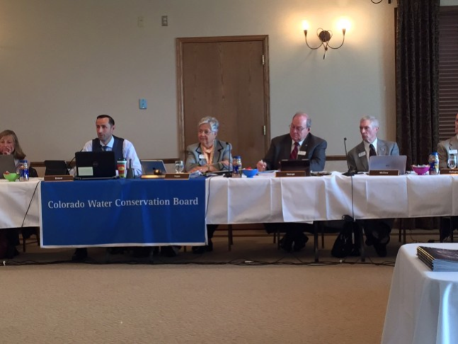
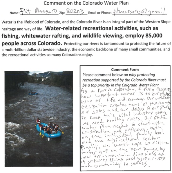
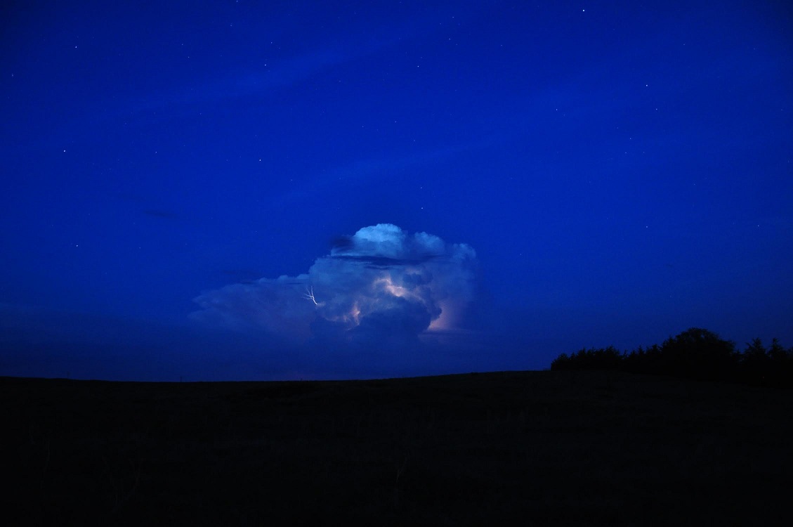


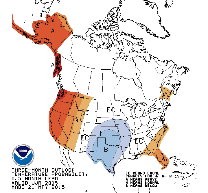


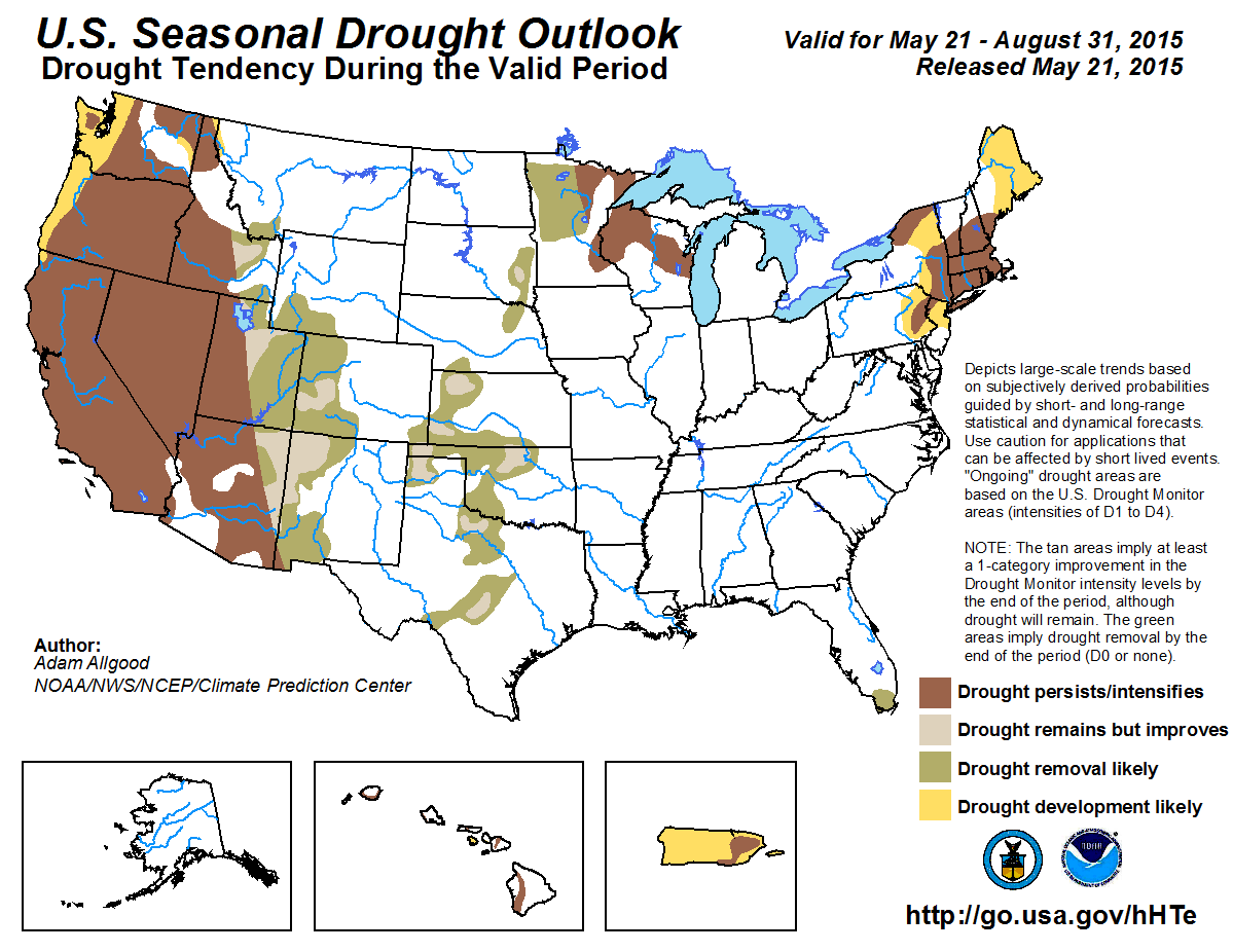


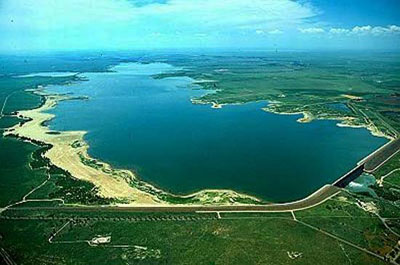

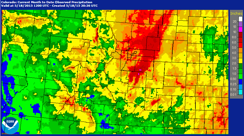

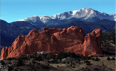

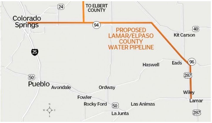