
From The Telluride Daily Planet (Stephen Elliott):
Snowpack across the West, including in the Telluride area, is melting earlier than usual, according to a forecast released Friday by the United States Department of Agriculture’s Natural Resources Conservation Service.
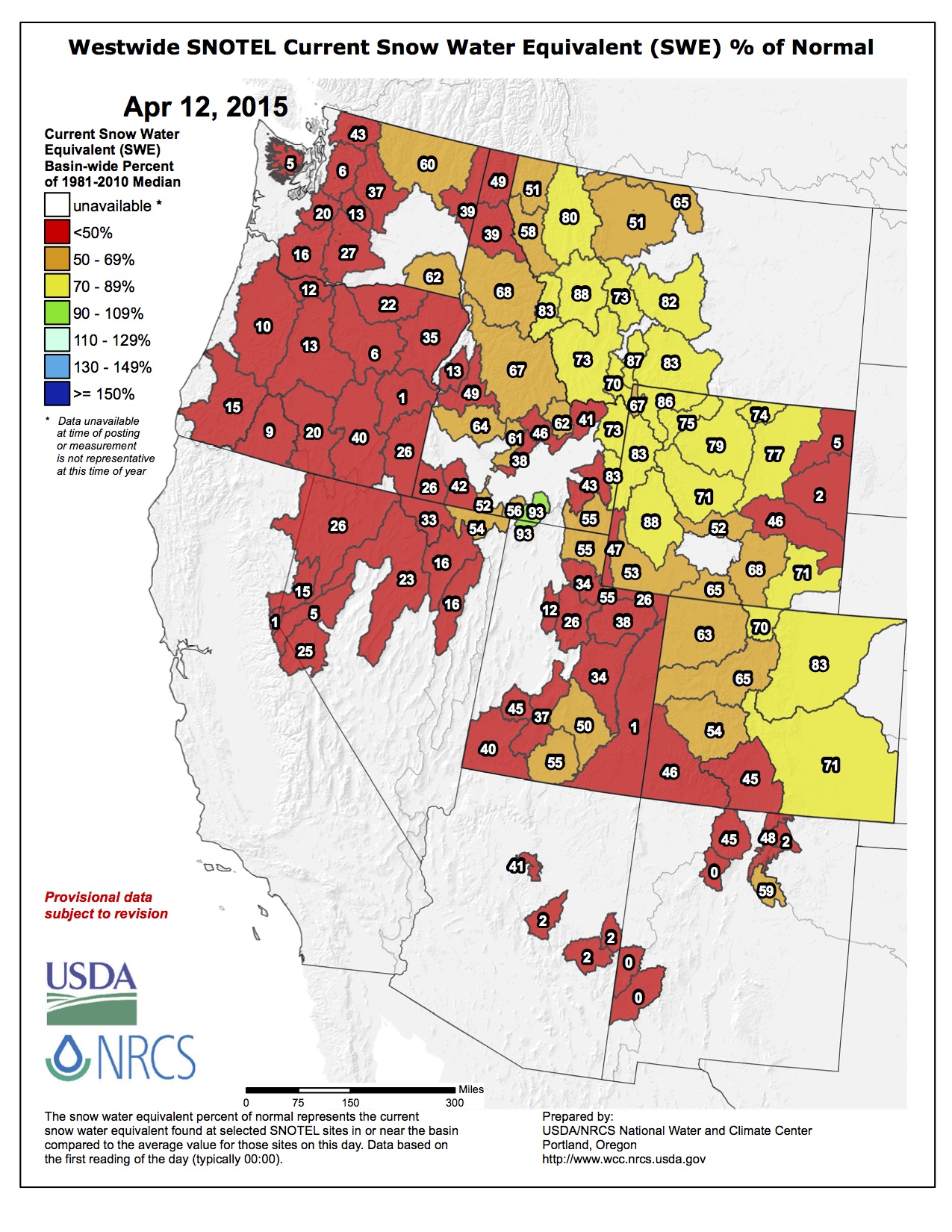
“March was warm and dry in most of the West; as a result, snow is melting earlier than usual,” NRCS Hydrologist David Garen said in the press release. “The only holdouts are higher elevations in the Rockies. Look at the map and you’ll see that almost everywhere else is red [indicating less than half of the normal snowpack].”
NRCS’ SNOTEL snowpack report from Friday shows snow and water levels in the San Miguel, Dolores, Animas and San Juan River basins are down from typical median levels. At Lizard Head Pass, current equivalent snow water levels are 6.2 inches, compared to a 30-year median of 15.8 inches. At Lone Cone, Friday’s reading was 1.5 inches, compared to a median of 14.1, just 11 percent of the usual snowpack.
According to the report, the overall snowpack in the San Juan, Animas, Dolores and San Miguel basins is 49 percent of the median for the last 30 years. Last year at this point, the snowpack in the local basins was 62 percent of the 30-year median.
Early snowmelt could mean reduced stream flow for local rivers this summer. In Western states, snowmelt accounts for the majority of summer water supply, according to the NRCS, so information about snowpack is an indicator of future water availability.
For businesses that rely on stream flows, like fly fishing and rafting outfitters, the low snowpack and early runoff could impact their bottom line, but maybe not in the way you’d expect.
Matt McCannel, head fly fishing guide for RIGS Adventure in Ridgway, said low runoff makes catching fish easier, but it can be harmful to the fish. Heavy runoff can make water too muddy and fast to fish…
According to another report released last week by NRCS’ Colorado Snow Survey Program, the state’s snowpack might have peaked as much as a month early.
The report says April 9 is typically when Colorado’s mountain snowpack is peaking or at its highest levels for the winter season. If warm temperatures and low precipitation continue this spring, the peak this year will have occurred March 9, according to the report.
“While late season snowstorms large enough to provide the kind of moisture we need in the mountains of Colorado are possible, they are not probable at this point,” NRCS Colorado Snow Survey Program Hydrologist Brian Domonkos said in the report. “Coloradans and other downstream water users should be prepared for below average stream flows this spring and summer provided near or below average precipitation.”
From Steamboat Today (Matt Stensland):
Turns out the thick layer of ice that blanketed Steamboat Ski Area on opening day may have been a blessing in disguise.
The infamous crust covered 40 inches of fresh powder that never got poached, but the added moisture contributed to the staying power of the snow going into closing weekend, according to a ski area official. Groomers also deserve a lot of the credit…
With closing day on Sunday, the ski area this year has seen 231.75 inches of snow. Record-low snowfall of 11.75 inches in January did not help the situation. The snowpack held on though.
From the Fort Collins Coloradan (Stephen Meyers):
The [Cache la Poudre] river, as measured at the mouth of the Poudre Canyon, flowed at 227 cubic feet per second, or cfs, on Thursday. The average discharge for April 9 is 80 cfs, according to Colorado Division of Water Resources.
With the commercial rafting season a month away, local outfitters hope the popular river doesn’t peak early. They also are hoping April brings one last snowstorm to help feed Colorado’s dwindling snowpack, which typically peaks about April 9 in Colorado and later in the month in Northern Colorado.
Peak runoff on the Poudre River usually hits in late May or early June. The average peak runoff is 2,928 cfs, according to the Northern Colorado Water Conservancy District.
Snowpack for the South Platte River Basin, which feeds the Poudre River, is at 85 percent of its historical average, Natural Resources Conservation Service data show.
From the Sky-Hi Daily News:
Area snowpack readings fell precipitously during the month of March, according to the USDA Natural Resources Conservation Service.
NRCS Kremmling Field Office snow surveyor Mark Volt took the April 1 snow survey measurements during the last days of March and found snowpack for Middle Park and the Upper Colorado River Basin stands at only 78 percent of average.
The survey conducted the month prior showed readings close to 100 percent . At this time last year, area snowpack stood at 144 percent. By contrast, during the drought year of 2002, it was 62 percent on April 1.
Snowpack in the mountains above Middle Park ranges from 26 percent to 107 percent of the 30-year average.. Snow density is averaging 28 percent, which means 1 foot of snow contains 3.3 inches of water.
“Irrigators, towns, river runners and other water users can expect lower than normal river levels this summer,” according to the NRCS report…
On the bright side, reservoir storage in the Colorado River Basin stands at 124 percent of average after last year’s above average snowpack and wet summer…
Statewide, significant snowpack gains in late February and early March were a result of a short-lived weather pattern.
“Afterward, the proverbial faucet shut off yielding minimal precipitation through the remainder of March,” the report says. “The period of March 6th through April 1st was the second driest for the period of record dating back to 1986; only 2012 saw a drier March 6th through April 1st period.”
The report continues, “To compound the issue, early spring temperatures this year have caused snowpack melt, observed most particularly at lower and some mid-elevation SNOTEL sites. Seasonal snowpack decline this early in the spring is rare and only occurs in one out of every 10 years. Water year 2012 was the extreme case in which snowpack melt began and continued unabated for the remainder of the spring due to above normal temperatures.”