Releases from Crystal Dam will be increased from 1150 cfs to 1250 cfs on Wednesday, April 29th at 9:00 AM. This release increase is in response to an increase in diversion to the Gunnison Tunnel. The current forecast for April-July unregulated inflow to Blue Mesa Reservoir is 450,000 acre-feet which is 67% of average.
Flows in the lower Gunnison River are currently above the baseflow target of 890 cfs. River flows are expected to stay above the baseflow target for the foreseeable future.
Pursuant to the Aspinall Unit Operations Record of Decision (ROD), the baseflow target in the lower Gunnison River, as measured at the Whitewater gage, is 890 cfs for April and May.
Currently, diversions into the Gunnison Tunnel are 800 cfs and flows in the Gunnison River through the Black Canyon are around 350 cfs. After this release change Gunnison Tunnel diversions will be around 900 cfs and flows in the Gunnison River through the Black Canyon should be around 350 cfs. Current flow information is obtained from provisional data that may undergo revision subsequent to review.
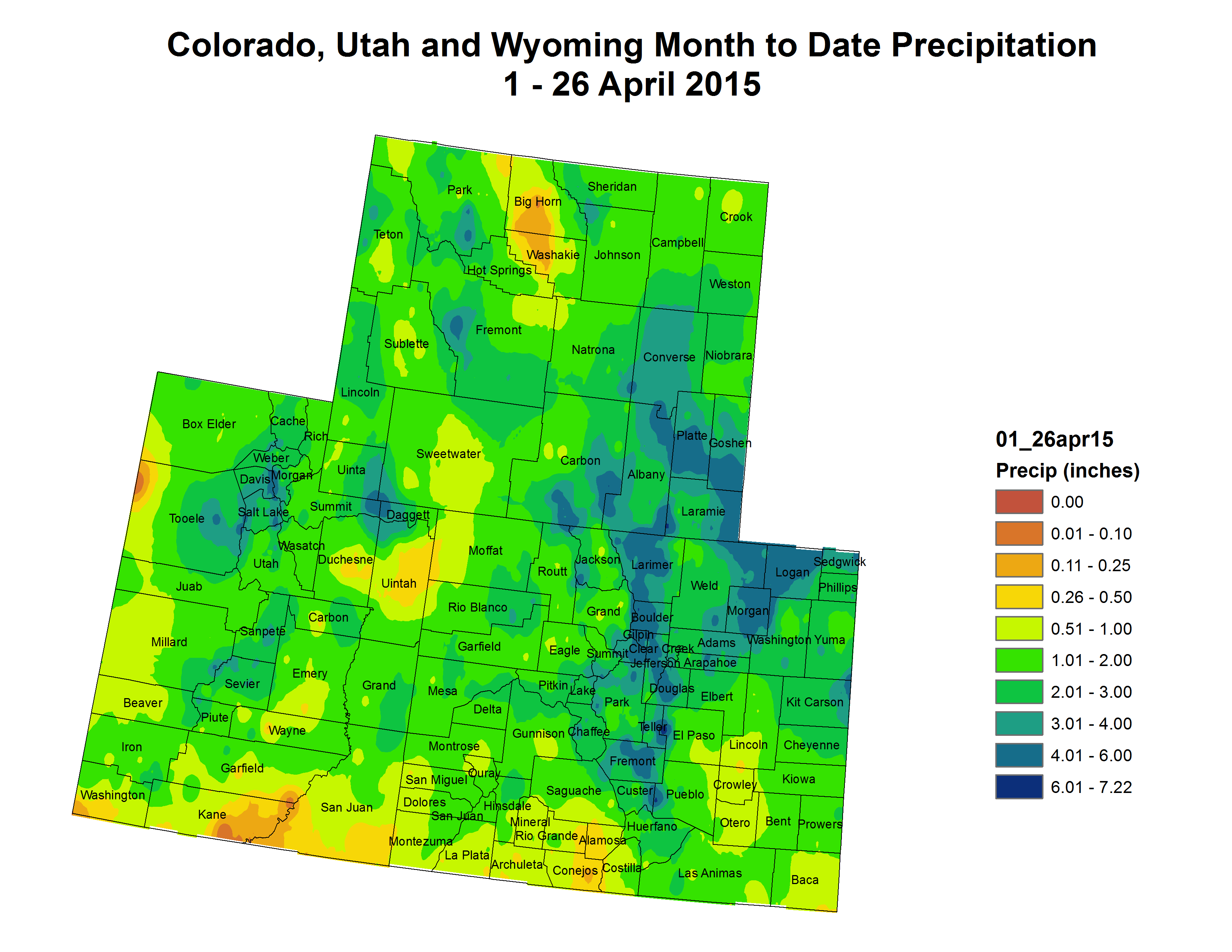
Upper Colorado River Basin month to date precipitation April 1 thru April 26, 2015 via the Colorado Climate Center Click here to read the current assessment. Click here to go to the NIDIS website hosted by the Colorado Climate Center.
The surface of the sprawling reservoir outside Las Vegas late Tuesday afternoon fell to 1,079.76 feet above sea level — nearly 140 feet below capacity — as the prolonged drought continues to evaporate the beleaguered Colorado River system.
Mead’s chalky white shoreline is advancing as the waters quickly recede.
For California, Arizona and Nevada, which draw water from Mead, a grim situation is about to get worse: Officials estimate that Mead will drop to the unprecedented low elevation of 1,073 feet as the hottest summer months bear down, with less snowpack in the Rocky Mountains to recharge the Colorado River.
“We’re only at 38% full. Lake Mead hasn’t been this low since we were filling it in the 1930s,” said Rose Davis, a spokeswoman for the U.S. Bureau of Reclamation in Las Vegas. “All the way around, this is bad news. There’s not much good to say about 15 years of drought, no matter how you look at it.”
Lake Mead, which meanders miles into the parched Nevada desert, held back by the Hoover Dam, is drawing closer to the 1,075-foot level, below which officials would declare a water emergency and begin rationing water allotments to Nevada and Arizona…
U.S. Bureau of Reclamation officials say there is a 21% chance of Lake Mead plunging below 1,075 feet next January. The odds increase to 54% for 2017.
It’s safe to say that the mood among many Western water managers is grim. When talking about drought or climate change, many still give that obligatory nod toward faith or hope—saying things like “Maybe the rains will come” or “Let’s hope next year’s better”—but the days of blind optimism are long past.
That was the case in early April, when the US Bureau of Reclamation’s Albuquerque Area Office hosted a meeting on the bureau’s plans for the Middle Rio Grande .
With few exceptions, the news across most of the Western United States has been bad, bureau hydrologist Ed Kandl said at the meeting. “If there’s one bright spot—you can cross your fingers—it’s the probability for a good monsoon,” Kandl said. “Of course, they’ve been saying that for a few years now. But this is what we have to hang our hat on.”
Along with the US Army Corps of Engineers, the bureau—which supplies water to cities, farmers and endangered species in the Rio Grande—looks to an array of data to plan out its water operations, which involve moving water between reservoirs, complying with state and federal laws, and trying to make sure no one goes without water.
People like Kandl look at things like snowpack in the watershed’s mountain ranges, streamflow forecasts, reservoir levels and temperatures. Then, they compare current conditions with similar years in the past to predict what might happen in the spring and summer. That’s the time when demands for water—from farmers, city dwellers and even plants in the bosque—are the greatest.
At the bureau’s meeting in Albuquerque, Kandl pointed out that the Sangre de Cristo Mountains, near Santa Fe, received about an average amount of snow this season. The bad news, he said, was that by early April, it was already melting.
As the climate warms, scientists have shown that snowpack moves higher in elevation and farther north. And that snow also melts earlier in the season.
This year, measurements at the Otowi Gage on the Rio Grande, north of Santa Fe, show that the river reached its peak spring flows on April 2.
That’s more than a month early.
The endangered silvery minnow will have a rough summer: This year, water supplies are so tight that the bureau does not expect to be able to release water from upstream reservoirs to create the spike in flows that help the minnows spawn. And the river will likely dry again south of Albuquerque from mid-June until the conclusion of irrigation season at the end of October. For the second year in a row, users with rights to water that comes from the San Juan River in Colorado and into the Rio Grande via the Chama may not get their full allotments of water.
From the Colorado Springs Post Independent (Pam Zubeck):
Because of the plant’s resistance to heat and drought, the Army Corps of Engineers used it in the mid-19th century to stabilize riverbanks against erosion. Then, during the severe drought of the 1930s on the Great Plains, farmers deployed it and its companion, invasive Russian olive, to provide windbreaks.
In the decades since, the story has shifted. Tamarisk, which can grow to 20 feet tall, has proliferated with a vengeance, colonizing thousands of miles of riparian corridors in the West, including those along the Front Range. It guzzles water, squeezes out any competitors, and sterilizes wetlands by leaving soils parched with salinity — hence its other name, saltcedar.
Besides being hard to destroy, a single plant’s blossoms produce thousands of seeds, which easily take root. Tamarisk, by one account, has multiplied 150-fold in just 100 years and now occupies up to 1.5 million acres in the western United States.
Even as water resources are taxed amid drought conditions, this ever-spreading exotic drinks freely via taproots that can reach 50 feet into the ground. One analysis put its consumption of water along the Arkansas River between Pueblo and the Kansas state line as enough to serve 376,000 people annually.
The body of research on the plant is massive and growing. Many have taken up the cause of eradication: government agencies, nonprofits and thousands of volunteers, as well as scientists and researchers, including a Colorado College botany professor and his students. Congress even adopted a law in 2006 ordering the Interior and Agriculture departments to get involved, though significant funding was never allocated.
Some new strategies for controlling tamarisk — including deployment of an insect, which has grown controversial due to its destruction of habitat for an endangered species — show promise. But the war on tamarisk is far from over, and warming temperatures due to climate change could help it spread farther by creating hospitable conditions in new areas.
Its role as villain may be relatively new, but tamarisk has fully embraced the part by being very hard to vanquish.
According to the Global Invasive Species Database, there are three varieties of tamarisk on Earth: tamarix aphylla (shrub), tamarix parviflora (tree) and tamarix ramosissima (tree, shrub). The last type prevails in the American West, in a spread the database refers to as “a massive invasion.”[…]
Eradication efforts began on the local level sporadically in the 1940s, but didn’t get traction on a wider scale until the 1990s, when a project on the Rio Grande River south of Albuquerque was undertaken.
About 15 years ago, the Tamarisk Coalition was formed. Today it works with more than 100 partners to restore riparian lands overrun with tamarisk through education and removal projects.
Some of those were undertaken along the Dolores and Colorado rivers with the help of Troy Schnurr, a ranger with the Bureau of Land Management in Grand Junction. The stretch Schnurr and others worked on isn’t accessible by heavy equipment, so crews had to raft down the river, work by hand with chainsaws and apply herbicides to stumps.
The project covered 25 miles and took 15 years.
“It can be overwhelming when you start,” Schnurr says. “There’s a lot of repair work, reseeding, replacement because the tamarisk has been there so long. That plant’s gonna be around for quite a while.”
Shelly Simmons, assistant district forester with the Colorado State Forest Service, explains it like this.
“What happens is resprouting,” she says. “Tamarisk has an aggressive root system. Once it does get established, you’re going to have to watch it for five years and treat it for regrowth. It’s rare if you get 100 percent control the first time you try to control it.”
Simmons works with volunteers, land owners and various agencies, including conservation districts, attacking tamarisk in the Purgatoire basin, Chico Creek, Fountain Creek, Huerfano Creek and the main stem of the Arkansas River.
“There’s been a lot of workshops in the Lower Arkansas Valley over the years,” she says. “We focus on riparian restoration, so we’ve had a lot of land managers and land owners attend those workshops. If a landowner feels they have the equipment and the means, they can undertake projects on their own land.” That was the case in an area along the Arkansas east of Pueblo and south of Highway 50, where tamarisk was cut and piled into heaps several years ago…
The act did result in a peer-reviewed assessment of tamarisk, though, completed in 2010 by the U.S. Geological Survey. That assessment puts a lot of stock in saltcedar leaf beetles (Diorhabda elongata), citing a study area in Nevada that showed a 65 percent mortality rate in saltcedar five years after the beetle was unleashed there. The beetles “consume saltcedar leaves, depleting root energy reserves until they are exhausted and the plant dies,” the assessment says.
These beetles came to Colorado about a decade ago, Beaugh says. Initially imported from Asia where the plant originated, the beetles are collected from areas on the Western Slope, where they’re well-established, and housed at the Palisade Insectary, run by the Colorado Department of Agriculture’s Biological Pest Control Program. From there, they’re shipped around the state, including to the Arkansas River corridor and Fountain Creek.
They arrive in cardboard jugs that resemble ice cream containers. Simmons says workers perch the cartons amid tamarisk bushes, and simply open the lids. The beetles, 1,500 per jug, crawl out and go to work. About 10,000 beetles are released per site, Simmons says, ideally “where tamarisk trees are younger and more succulent.”
A Colorado Agriculture Department newsletter says the beetle had settled into the Arkansas Basin by 2012, where some sites have been defoliated multiple times and up to 60 percent of the target tamarisk trees have been killed. The state has taken to calling the beetle “a valuable management tool.”
It also lies at the heart of the CC professor’s latest research. Heschel wants to know how the beetle affects tamarisk’s consumption of water; data to date suggest that in some cases, a tamarisk plant under siege only gets more aggressive.
“When the beetle attacks tamarisk,” Heschel says, “tamarisk tends to increase its water use to compensate for getting attacked.”
The study, which includes one site just south of the Fountain Creek Regional Park Nature Center, also looks at whether tamarisk that survive the beetle attack somehow become even heartier and more thirsty. “Is that what we’re accidentally doing?” Heschel says. “I don’t know the answer to that.”[…]
Southwestern Willow flycatcher
Use of the beetle, however, is being curtailed in some other states due to its potential to destroy habitat for the endangered southwestern willow flycatcher. In September 2013, the Center for Biological Diversity, and the Maricopa Audubon Society, in Arizona, filed a lawsuit against the U.S. Department of Agriculture, alleging the beetles were destroying the songbird’s nesting areas. The lawsuit, according to the Los Angeles Times, accused the department’s Animal and Plant Inspection Service of failing to protect the flycatcher, which nests in tamarisk thickets. The case is pending before a federal judge.
Robin Silver with the Center for Biological Diversity says while the lawsuit points to problems in Utah, Arizona and Nevada, the beetles also have invaded nesting areas in southwest and south central Colorado. “[Federal agriculture officials] said, ‘Don’t worry, because the native plants will come back,'” Silver says. But he argues that “unless you change the hydrology, you’ll end up with nothing” in the way of vegetation after tamarisk has been removed. “The only chance you have,” he says, “is to get out ahead of the beetles and change some of the hydrology for plant recovery. [Officials] don’t want to do that because it costs money.”
Patrick Shafroth, a research ecologist with the USGS at the Fort Collins Science Center, agrees that restoration is crucial in determining what vegetation comes next in the context of tamarisk control. As stated in a 2011 paper by USGS and other researchers about consequences of using the beetle, “Conditions in many areas now occupied by tamarisk have been so altered anthropogenically that recolonization by native willows and cottonwoods is unlikely without intensive restoration efforts.”
Considering the sky-high cost and massive efforts to restore large areas affected by the beetle, the paper says, “widespread tamarisk mortality will likely result in a net loss in riparian habitat for at least a decade or more.”[…]
And then there’s the wild card of climate change. Despite all attempts to rid rivers and streams of tamarisk, the hearty plant could get a leg up from rising temperatures. While Shafroth considers the question of climate change’s influence “uncertain,” the 2010 USGS assessment and other scholarly works say it could foster tamarisk’s proliferation, given that it thrives in hot, dry weather, and parts of Colorado remain in moderate to severe drought conditions.
From the assessment: “Further expansion of saltcedar northward (and to higher elevations) is likely to occur due to climate warming.”
All of which makes Shafroth wonder if this scoundrel of the West is a cause, or merely a symptom, of the real problem.