Trial opens on Walker’s SDS costs — The Pueblo Chieftain

Southern Delivery System route map -- Graphic / Reclamation
Southern Delivery System route map — Graphic / Reclamation

From The Pueblo Chieftain (Chris Woodka):

A contentious jury trial over the value of easements for the Southern Delivery System pipeline crossing Walker Ranches opened Monday in District Judge Jill Mattoon’s courtroom.

Colorado Springs Utilities offered about $100,000 for the easements, and has paid rancher Gary Walker $720,000 for moving cattle to alternate grazing pastures. Walker claims the value of SDS impacts on his land are $25 million, according to court documents. The 66-inch diameter pipeline has a 50-foot permanent easement and 100-foot temporary easement across 5.5 miles of Walker Ranches.

The total length of the SDS pipeline from Pueblo Dam to Colorado Springs is about 50 miles.

Walker spent about eight hours on the stand Monday and Tuesday testifying about the impact SDS has had on his cattle, violating existing conservation easements, introducing toxic materials and invasive species and other issues he has experienced since Colorado Springs constructed the underground pipeline in 2011. Water from the pipeline scar flooded other areas of the ranches and contributed to erosion, Walker said.

Walker stressed throughout that he does not believe he has been treated fairly in his dealings with Colorado Springs.

“After dealing with Colorado Springs since 2011, I’m worried about anything that occurs between you and I,” Walker pointedly told Colorado Springs attorneys during a testy cross-examination.

Colorado Springs in February won an appeal to the state Supreme Court to overturn a $500,000 judgment for court costs awarded by retired District Judge Victor Reyes in December. Walker had claimed Colorado Springs delayed the trial while he accrued costs for expert witnesses.

Colorado Springs is questioning Walker’s basis for damages, claiming conservation easements do not affect the parcels where the pipeline was built and that Pueblo County’s 1041 permit is an agreement between Colorado Springs and Pueblo County, not individual landowners. One of the conditions of the 1041 permit states that landowners should not have out of pocket expenses because of real estate transactions related to SDS.

Because of the large volume of documents in the case, the trial is expected to take about two weeks.

More Southern Delivery System coverage here.

Aspinall Unit operations update: Current forecast for inflow into Blue Mesa = 71% of avg

Blue Mesa Reservoir
Blue Mesa Reservoir

From email from Reclamation (Erik Knight):

Releases from Crystal Dam will be increased from 1050 cfs to 1150 cfs on Wednesday, April 15th at 9:00 AM. This release increase is in response to an increase in diversion to the Gunnison Tunnel. The current forecast for April-July unregulated inflow to Blue Mesa Reservoir is 480,000 acre-feet which is 71% of average.

Flows in the lower Gunnison River are currently above the baseflow target of 1050 cfs. River flows are expected to stay above the baseflow target for the foreseeable future.

Pursuant to the Aspinall Unit Operations Record of Decision (ROD), the baseflow target in the lower Gunnison River, as measured at the Whitewater gage, is 1050 cfs for April.

Currently, diversions into the Gunnison Tunnel are 700 cfs and flows in the Gunnison River through the Black Canyon are around 350 cfs. After this release change Gunnison Tunnel diversions will be around 800 cfs and flows in the Gunnison River through the Black Canyon should be around 350 cfs. Current flow information is obtained from provisional data that may undergo revision subsequent to review.

Weekly Climate, Water and Drought Assessment of the Upper #ColoradoRiver Basin

Upper Colorado River Basin March 2015 precipitation as a percent of normal via the Colorado Climate Center

Click here to read the current assessment from NIDIS. Click here to go to the NIDIS website hosted by the Colorado Climate Center.

More Colorado River Basin coverage here.

The Arkansas Basin Roundtable finishes up their basin implementation plan #COWaterPlan

Flood irrigation in the Arkansas Valley via Greg Hobbs

From The Pueblo Chieftain (Chris Woodka):

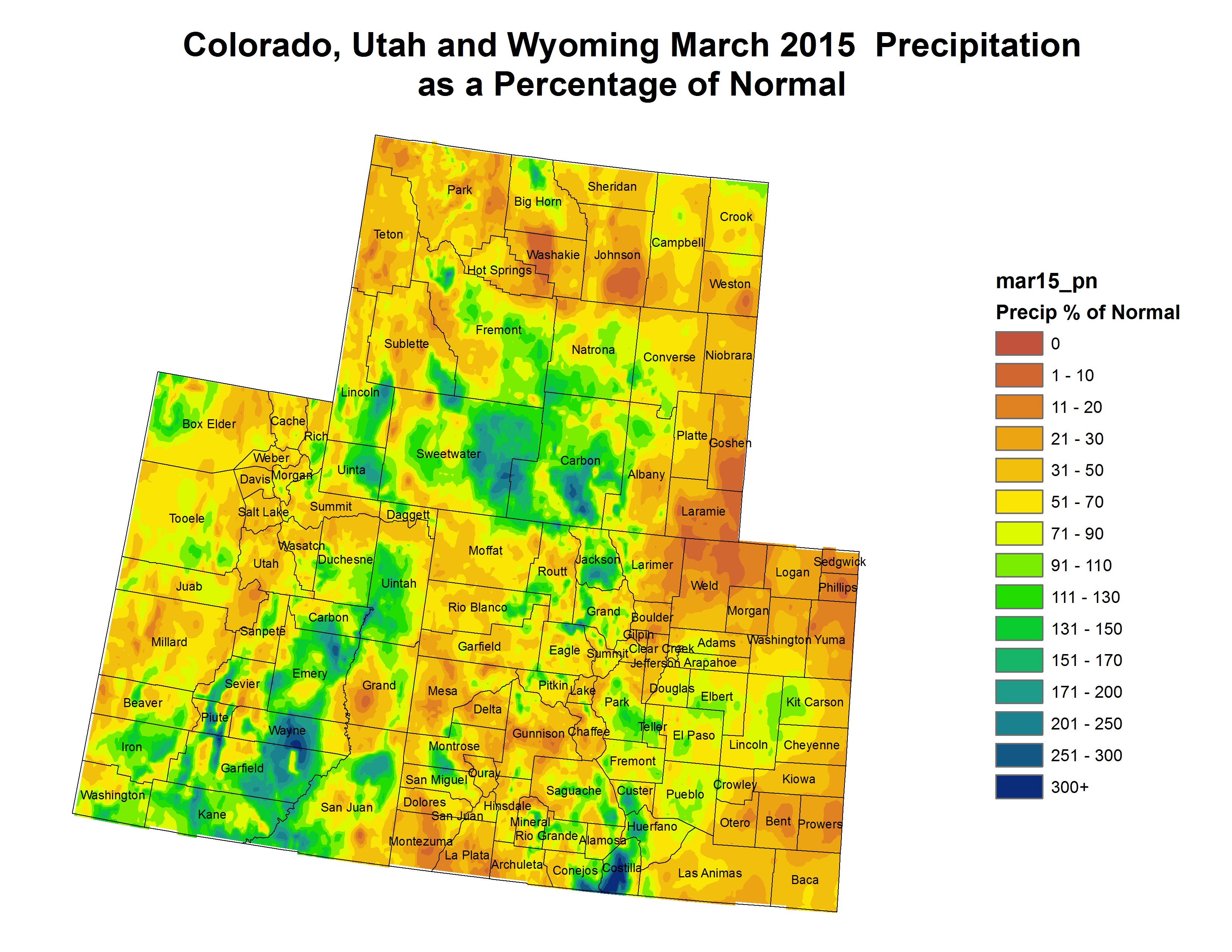
Water plans don’t always pan out.

The Arkansas Basin Roundtable last week wrapped up a basin implementation plan that was two years in the making. The aims of the plan are to preserve agriculture in the Arkansas Valley while filling the needs of a growing population, primarily in El Paso County.

It’s part of a state water plan ordered up by Gov. John Hickenlooper as a way to accommodate a growing population without diminishing the state’s agricultural and environmental needs for water.

The roundtable hammered out differences between geographic areas and types of water use among its members, with the common theme of protecting what we have.

But a century ago, the vision was vastly different. It was a dream of turning the valley into an agricultural mecca on an industrial scale. The water plan of that era was spelled out in 1910, when Pueblo hosted the 18th National Irrigation Congress.

Pueblo was Colorado’s second largest city at the time and the industrial and rail hub for the region. Agriculture was seen as the wave of the future. The optimism at the Irrigation Congress appeared to be an irresistible force at the time and the seeds for grand plans were being planted at the time. A souvenir program from the 1910 convention in Pueblo was recently discovered in the estate of Bill Mattoon, a longtime Pueblo water attorney.

The expansion of irrigated agriculture was seen as a national duty, much the same as California Gov. Jerry Brown recognized its importance in context with the current drought.

“There is no movement more important with reference to the food supply of this nation than the progress of irrigation of the arid and semi-arid lands of our Western, now desert, plains,” President William H. Taft wrote in the program.

The U.S. Reclamation Service outlined plans for two dozen major water projects — dams, ditches and tunnels that would redirect rivers — in all Western states. Those included the Gunnison-Uncompahgre tunnel near Montrose, completed in 1909. The agency, forerunner of the Bureau of Reclamation, had just been formed in 1902.

Congress had just passed a $20 million program to begin building those projects.

Kansas and Colorado apparently were taking a break in 1910 from their century-plus battle over the Arkansas River. In the souvenir program, R.H. Faxon, editor of the Evening Telegram in Garden City, Kan., pushed the phrase “Valley of Content” for the Arkansas Valley shared by the two states. The Arkansas Valley Commercial Association, presided over by Faxon, included officers from Rocky Ford and Canon City as well.

Crowley County, which would be decimated by water raids in the 1970s and ’80s, was not even a county at the time — that would come in 1911. But the Desert Land Reservoir and Canal Co. was a scheme to open up 200,000 acres of land to the east for irrigation.

It would use stored flood waters from Lake Meredith, which was then part of Otero County, which was targeted as a 400,000 acre-foot reservoir — roughly 10 times its present-day capacity. The ambitious plan would also tie in Horse Creek and Adobe Reservoirs, which are part of Fort Lyon storage.

“There is no other situation on the river where it is possible to build a ditch large enough to divert the entire volume of your average flood,” the famed engineer James D. Schuyler of Los Angeles proclaimed.

Kansas, once it got over the Valley of Content, would have more to say about that in the future. Supreme Court battles with Kansas that would culminate with a 2009 final judgment have limited Colorado’s ability to divert the waters of the Arkansas River.

The program of the 1910 National Irrigation Congress reported 262,000 acres under irrigation in the state, and dreamed of placing 2.5 million acres under irrigation after more than 100 new irrigation projects were completed.

That part came true. The 2012 Census of Agriculture listed 2.5 million acres under irrigation in the state, which by the way is a decline of about 300,000 acres from 2007.

Pueblo was seen as a distribution center for the fruits of the land, which included large-scale orchards along the lines of those that already had seen success in places like Montrose and Grand Junction. Pueblo County’s own crops included cantaloupes, celery, alfalfa and corn.

But the crop that would become so important to the valley was sugar beets, already a valuable commodity for the Arkansas Valley. There were 16 sugar beet mills in the state at the time, with seven in the Arkansas Valley.

An unsigned article, “When We Shall Produce Our Own Sugar,” explained how the United States raised only one-fourth of the 3.6 million tons of sugar it consumed each year. Colorado and California were the leading producers.

We can’t get enough of the stuff. In recent years, Americans consumed about 10 million tons of sugar annually, with about three-fifths of that produced domestically.

Sugar beets are still grown and processed near Greeley. But things did not turn out so sweet for the Arkansas Valley, which lost all of its sugar beet mills — and the acreage and water that came with them — by the 1980s.

Above all, the 1910 Irrigation Congress promoted the idea of the small family farm.

“Are you looking for an ideal home in a land of sunshine?” one tempting advertisement for land near Delta asked.

“Farmers beginning to see the light,” blared an ad for the Pueblo-Rocky Ford Land Co.

“We have some splendid propositions for colonization,” an ad for San Luis Valley farms offered.

Article after article in the 148-page publication touted methodical paths the enterprising farmers of the day could use to develop their land.

Colorado in 1910 was wide open for agricultural development, and that seemed to be the water plan of the era: to develop and use as much as possible to grow crops.

A century on, that vision is fading, but still defended as a value by the water planners of the present. One of the planks added by the roundtable to its basin implementation plan last week included a preference for using the water in the Arkansas River basin at home and not allowing it to leak away to other basins.

Snowpack/runoff news

Westwide SNOTEL snow water equivalent as a percent of normal April 14, 2015 via the NRCS

I drove across southern Colorado over the past couple of days. Some snow courses up high looked OK but no snow at lower elevations. The snow in the Sangre de Cristos was mostly gone.

Colorado Supreme Court upholds San Miguel River instream flows — Telluride Daily Planet

From the Telluride Daily Planet (Mary Slosson):

The CWCB initially decided in 2011 to protect a 17-mile stretch of the San Miguel River stretching from Calamity Draw down to the confluence with the Dolores River in order to prevent water levels from dropping too low for three fish species — the flannelmouth sucker, bluehead sucker and the roundtail chub — to survive and thrive.

All three are classified by the U.S. Forest Service Rocky Mountain Division as sensitive species, with human water diversion listed as the main reason for their precarious situation.

“Fundamentally what this case is about is that environmental water rights are going to be treated just the same as other water rights,” said Rob Harris, a staff attorney for conservation group Western Resource Advocates, which filed a supporting brief in the case.

“It’s a model for the West to follow on how to provide that local voice while also creating concrete, substantive protections that keep water in rivers for generations to come,” Harris continued…

Officials at the Bureau of Land Management and the Colorado Department of Wildlife requested the instream flow protections in 2008. A district water board upheld the 2011 CWCB vote and that was that, until the Farmers Water Development Company objected. The group said that the CWCB’s actions were quasi-judicial in practice and in violation of the Constitution.

The Colorado Supreme Court disagreed and, in a decision authored by Justice Allison H. Eid, upheld the water board decision by affirming that the CWCB was acting in a quasi-legislative capacity granted it by the state legislature.

“We’re very, very pleased with the ruling,” said Linda Bassi, the chief of the CWCB Stream and Lake Protection Section. “It was an important decision for our agency.”

State lawmakers empowered the CWCB in 1973 to use instream flow water rights to protect the environment of streams, rivers and lakes in order to assist imperiled fish and other species and to protect nearby vegetation.

“It’s a big deal for us because the court affirmed that the process my board uses is correct,” Bassi added. “It strengthens our whole program.”

The Colorado high court’s ruling is particularly important for the board in 2015, as several of its proposed instream flow protections have already been challenged. One of the sections in question is along the Dolores River in Montrose and Mesa Counties.

More San Miguel River watershed coverage here.

Northern Water bumps up quota to 70% for the season due to record storage

Here’s the release from the Northern Colorado Water Conservancy District (Brian Werner):

Northern Water’s Board increased the Colorado-Big Thompson Project quota allocation to 70 percent today. With C-BT Project storage at an all-time high for April 1, local storage reservoirs above normal and with mountain snowpacks declining, the Board chose to make available an average supplemental quota for 2015.

The approval increased available C-BT water supplies by 20 percent, or 62,000 acre feet, from the initial 50 percent quota made available in November.

The Board considered input from farmers and municipal water providers, demonstrating the varying demands and complex circumstances directors must consider when setting the quota. C-BT supplements other sources of water for 33 cities and towns, 120 agricultural irrigation companies, various industries and other water users within Northern Water’s 1.6 million-acre service area.

Directors carefully considered streamflow forecasts, which have declined since the beginning of March to below average in all C-BT related watersheds. Snowpack in watersheds contributing to C-BT inflow have gone from above average on March 1 to approximately 15 percent below average in April. In addition, March precipitation throughout Northern Water’s boundaries was just 21 percent of average.

Directors also took into consideration the drought throughout much of the American West and the potential for a dry spring or summer. Board Vice-President Kenton Brunner emphasized, “The Board always has the option to increase the quota in future months if conditions warrant.”

“We’re in good shape storage-wise and better prepared to have a down snowpack year than in many other years,” said Andy Pineda, Water Resources Department Manager. “The weather changes from year-to-year and we never know how much precipitation the mountains will receive, so having storage reservoirs this full is very beneficial for water users.”

Directors based their decision on the need for supplemental water for the coming year, while balancing project operations and maintaining water in storage for future dry years.

To learn more about Northern Water and the C-BT quota, visit http://www.northernwater.org.

More Northern Colorado Water Conservancy District coverage here.