“Climatic water deficit” is the culprit in Aspen forests dying in the southwestern US

doloresriveraspens

From The Week (Ryan Cooper):

A team of scientists, led by Dr. William Anderegg of Princeton, have been working on the aspen question, and their results were published today in Nature Geoscience. The answer is something called “xylem cavitation.” And unless we do something big about climate change soon, it will kill most of the aspens in the Southwest.

Here’s what that means. Trees transport water through their xylem tissue (one example of which is regular old wood), basically composed of millions of tiny tubes, or “conduits.” Xylem doesn’t work like a mechanical pump — instead, water flows up the tree trunk through capillary action. That flow is maintained through evaporation at the leaf surface, removing water at the top so more can replace it, and supplied by the roots drawing water from the soil.

In hot, dry conditions, like the early 2000s drought, water evaporates more quickly from the leaf surface — and there is less water in the soil to maintain supply. Anderegg and his team quantified both of these with a factor they called “climatic water deficit.” When the deficit is high, the water pressure inside the xylem decreases due to tension between the top and bottom of the tree.

If the pressure gets low enough, gas bubbles will spontaneously form in the water column — which is called cavitation. A bubble instantly blocks that particular xylem conduit and prevents the water from flowing. Block enough conduits, and the tree desiccates and dies.

It’s “like a tree heart attack,” says Anderegg. He and his team constructed a model of this cavitation mechanism, calculated a threshold at which aspens should die, and compared it with historical data on the early 2000s drought. They found pretty clear agreement, explaining about 75 percent of the tree mortality during that time (a good result, given how complex forests are).

2015 Colorado legislation: SB15-064 (Application Of State Water Law To Federal Agencies) dead #coleg

Photo via Bob Berwyn

From The Colorado Statesman (Marianne Woodland):

SB 64 sailed through the Senate Agriculture, Natural Resources and Energy Committee on an 8-1 vote. That included a “yes” vote from Sen. Kerry Donovan, D-Vail, whose district includes the Eagle County ski areas, as well as Crested Butte and Aspen. Sen. Mary Hodge, D-Brighton, also voted in favor of SB 64.

On the Senate floor, the bill picked up four more votes from Democrats, and passed on a 24-11 vote.

But instead of going to the House Ag Committee, where the previous versions had passed easily the last two years, SB 64 was assigned to the State, Veterans and Military Affairs Committee. And true to its reputation as the “kill” committee, the bill died on a 5-6 party-line vote. One of those “no” votes came from Rep. Mike Foote, D-Denver, who voted in favor of the 2014 version.

Sonnenberg was furious. He told The Colorado Statesman last week that it was just politics. “I don’t get it,” he said. “It’s politics at its worst, when we don’t defend Colorado water rights owners.”

This week, House Speaker Dickey Lee Hullinghorst, D-Boulder, defended her decision to send SB 64 to the State Affairs committee, and why she made that decision on a bill she’s supported for the past two years.

Hullinghorst said Tuesday she sent the bill to State Affairs because she wanted to see the issue addressed more broadly, and that she believed State Affairs was the appropriate committee. She said she changed her mind on the bill because of a legal opinion from Legislative Legal Services, although Legal Services issued the same opinion for the 2013 and 2014 bills.

“I believe that issue has been well-vetted, and we’ve had lots of good talk about it. But as a matter of fact, we have memos from Legal Services that tell us on two specific constitutional issues, that this bill is unconstitutional,” Hullinghorst said this week.

The first issue, according to the Legal Services memo, is that the federal government has preemption powers in this area. Preemption means that when a federal and state law conflict, the state law is considered invalid.

Second, the memo said the bill is considered special legislation since it is done for one specific agency. Hullinghorst said that bothered her more than the preemption issue. “I used my prerogative, I changed my mind.”

More 2015 Colorado legislation coverage here.

Snowpack news: The Upper #ColoradoRiver Basin (in Colorado) has started melting out

@USGS: Streamflow of 2014 — water year summary

More USGS coverage here.

Colorado’s snow is dust-free for the first time in a decade — the High Country News

Click on a thumbnail graphic to view a gallery of snowpack data from the Natural Resources Conservation Service.

From the High Country News (Krista Langlois):

This year, however, there appears to be a break in the cycle: Though a few storms have swept east from the plateau, they either haven’t had enough oomph to carry dust to the mountains, or they’re coming from places like eastern Utah where the dust was tamped down by late-winter snowfall. For the first time in a decade, March snowpack across Colorado is virtually dust free. Great news, right?

Not really, says Chris Landry, executive director of the Center for Snow and Avalanche Studies in Silverton, Colorado. Rather than cause for celebration, current dust- and snowpack conditions are about as close to worst-case scenario as you can get. For one thing, above-average temperatures statewide mean that in each of the 11 locations Landry sampled last week, the snow itself was “much warmer than usual. In some places,” he adds, “it was as warm as you can get and still be snow — warmed up all the way to zero degrees Celsius.”

Once snow hits that threshold, Landry says, it’s very unlikely to cool down again — meaning that even if skiers are lucky enough to get a few spring dumps, snowmelt in many places has passed a point of no return. Already, some stream gauges are showing runoff well above annual norms for this time of year.

Secondly, there’s just not much snow to begin with. In most Colorado watersheds, snowfall was subpar, and a long, dry, warm spell that lasted through February caused some slopes to become nearly bare — creating even more variation than usual between sunny, south-facing slopes and cool, shady ones. When Landry tramps around visiting data sites, he’s used to seeing a difference between conditions on the ground and the computer-generated SNOTEL maps, because SNOTEL sample sites tend to be flat and shady. This year, however, Landry worries the variations are higher than usual — so even maps showing snowpack at 67 percent of normal may be overstating what’s really out there. Less snow ultimately means faster rates of melting, and faster melting now means less water in streams and rivers this summer.

The last criteria for Landry’s “worst-case scenario” is a dry spring — which is exactly what we’ve had so far. Just as there have been few storms here in the mountains, there haven’t been many over the Colorado Plateau either, and that means conditions there are getting drier and dustier — primed for a big April dust storm. April is typically the biggest month of the year for dust events, and May isn’t far behind. So just because there’s virtually no dust out there right now doesn’t mean it’s not coming: “The Colorado Plateau is drying out,” Landry says, “And that almost ensures that if and when a major weather system moves through, dust will be available. We’ve had single dust events that in and of themselves would be more than adequate to really alter snowmelt.”

“Everybody is hoping for no dust,” he adds. “And that would be considered a good thing. But it’s also true that we’re a long way from being even reasonably hopeful that will be the case.”

From TheDenverChannel.com (Matt Makens):

The fire danger has increased this March. This is due to an unusually warm pattern with little moisture for most of Colorado.

The first week of March started with snow/rain and cool temperatures but the following three weeks were very warm and very dry.

The monthly average temperature was 4 to 8 degrees warmer than average for the state. Temperatures were near their averages for only a few days. Denver ends March more than 4-degrees warmer than its average…

This follows a dry start to the year. For three months in a row, temperatures remained warmer than average. This year, the only area of the state to have above average precipitation is a region of the Front Range along I-25 from Denver to New Mexico.

This dry and warm start to the year has raised concerns of the fire danger for the coming months.

Meteorologist Tim Matthewson of the Bureau of Land Management tells 7NEWS that the next 30 to 60 days will be critical for the fire season. To continue with below average precipitation could mean a bad fire season. He added, this is reminiscent of 2012, although not quite there yet.

“First and foremost, Western water is about politics, not policy” — Dan Beard #ColoradoRiver

deadbeatdamsdanbeard

From KUER (Judy Fahys):

The West used to solve its water troubles with dams. But now Dan Beard. a man who used to lead the nation’s dam-building agency, wants to shutter it.

Beard once oversaw the U.S. Bureau of Reclamation’s vast water network in the West, and he helped Congress decide on one billion dollars worth of finishing touches for the Central Utah Project.

But Beard says the water landscape has changed.

“In the middle of a drought, with climate change here and going to impact the horizon,” he says, “water is a much more active and high-priority issue.”

In his new book, Deadbeat Dams, Beard argues that the “Bureau of Wreck” – or W-R-E-C-K , as environmentalists used to call it – is a bureaucratic waste. He also advises tearing down the Glen Canyon Dam to make the Colorado River more efficient.

Beard says the water bureaucracy resists change.

“There are several things you’ve got to keep in mind when you talk about Western water,” he says. “First and foremost, Western water is about politics, not policy. The second thing is logic and common sense rarely play a role in resolving water problems.”

He calls conservation, smarter water pricing and innovation crucial to finding solutions.

More Colorado River Basin coverage here.

Southern Delivery System: The Pueblo County commissioners take first step to evaluate Colorado Springs’ 1041 permit compliance

Fountain Creek Watershed

From The Pueblo Chieftain (Jeff Tucker):

The Pueblo Board of County Commissioners got a first look at a resolution that will allow the board to retain legal counsel along with engineering consultants and other staff to evaluate whether Colorado Springs’ lack of any consistent stormwater funding is a deal-breaker for the Southern Delivery System.

The board took no official action on the measure, instead instructing attorneys Gary Raso and Ray Petros to fine-tune the resolution before it comes back for a vote.

The crux of the issue is the failure of a ballot measure in Colorado Springs in November that would have created a dedicated funding source for stormwater improvements in Colorado Springs that could mitigate the impact of runoff into the Fountain Creek.

The work that would be cleared by the resolution will allow staff to examine what’s been done so far and what still needs to be done for Colorado Springs to comply with the stormwater requirement in the SDS 1041 permit.

“We need to develop a factual basis for any action we take,” said Raso. “It would be the first time that Pueblo County would have an independently established set of facts about the stormwater flowing through the Fountain Creek.”

Petros told commissioners Monday that Colorado Springs has provided staff a summary of its stormwater expenditures.

Colorado Springs has indicated that it has budgeted $17 million this year for more improvements, but Petros said there’s yet to be any indication what those improvements are or if they’re among the 239 projects worth more than $534 million identified in 2013.

Commissioner Sal Pace said he wants a clear picture on what projects Colorado Springs has planned that directly mitigate impacts on the Fountain Creek and which ones are aimed at fixing the challenge of runoff from the various burn scars in the area.

It’s possible that building flood control projects for the burn scar will have an impact on the flooding in Fountain Creek. But Commission Chairwoman Liane “Buffie” McFadyen wondered whether the impacts of the Waldo Canyon Fire are accounted for under the current agreements over the SDS, since those were signed before the first spark of the catastrophic fire ever landed.

McFadyen also worried that the work set forth in the resolution may be at odds with the needs of the county’s own constituents in Pueblo West. The metro district ties into SDS.

“I don’t want to see Pueblo West used in a way that could be interpreted as gamesmanship in all of this,” she said.

Commissioner Terry Hart noted that the $50 million being paid to the Fountain Creek Watershed Flood Control and Greenway District likely won’t be enough to pay for the mitigation projects in Pueblo County and asked Petros and Raso to include a specific date in the resolution as to when the information will be ready.

Petros suggested the end of June, to give the newly elected mayor and City Council time to get sworn in after April 7 elections and for next month’s lawsuit over compensation by Colorado Springs to Walker Ranches to run its course.

However, Hart said he’d like to see it sooner.

“I didn’t create this problem,” he said. “What created this problem was the failure of the question in November.”

More stormwater coverage here.

What severe drought in the #ColoradoRiver Basin looks like — The Washington Post

Colorado River Basin including out of basin demands -- Graphic/USBR
Colorado River Basin including out of basin demands — Graphic/USBR

Click here to read the article from The Washington Post (Nick Kirkpatrick) and to check out the photo gallery from Lake Powell. Here’s an excerpt:

Lake Powell, one of the nation’s largest reservoirs, is now below 45 percent of its capacity.

Straddling the border between Utah and Arizona, the man-made reservoir is part of the Colorado Water Basin that supplies water to 40 million people…

For more than 14 years, the basin and the Western states have been plagued by drought. Almost every year, all of the water from the Colorado River is pumped out before emptying into the the Gulf of California.

“Many climate scientists think the Southwest is again due for a megadrought,” Jonathan Waterman wrote in National Geographic. “The Bureau of Reclamation’s analysis of over a hundred climate projections suggests the Colorado River Basin will be much drier by the end of this century than it was in the past one, with the median projection showing 45 percent less runoff into the river.”

More Colorado River Basin coverage here.

Snowpack news (Part 2): Gunnison and Yampa/White flirt with 2002 numbers, where’s Ullr?

Ullr: Guardian Patron Saint of Skiers

Snowpack news: South Platte Basin drops to 91% of normal (best in state)

Westwide SNOTEL snow water equivalent as a percent of normal March 29, 2015

Gov. Hickenlooper announces more than $34 million in grants awarded to local communities

Here’s the release from Governor Hickenlooper’s office:

Gov. John Hickenlooper and Kevin Patterson, interim executive director of the Colorado Department of Local Affairs (DOLA), today announced $34,240,176 in competitive grants has been awarded to 40 projects throughout Colorado through the Energy and Mineral Impact Assistance Fund grant program. Projects address key public improvements ranging from public facilities to water and wastewater systems in communities statewide.

“This grant program continues to be invaluable to Colorado’s smaller and rural communities,” said Hickenlooper. “With these funds, communities are able to plan for and implement substantial capital improvements, essential public projects and other services.”

DOLA administers the grant program, which assists political subdivisions that are socially and/or economically impacted by the development, processing, or energy conversion of minerals and mineral fuels. Funds come from the state severance tax on energy and mineral production and from a portion of the state’s share of royalties paid to the federal government for mining and drilling of minerals and mineral fuels on federally-owned land. The program was created by the legislature in 1977.

Types of projects funded by the program include construction of or improvements to water and sewer systems, roads, recreation centers, public safety and other public facilities, fire protection buildings and equipment, and local government planning.

“These dollars strengthen communities and are made possible through well-established partnerships between all levels of government and the energy industry. DOLA takes great pride in being a steward of these funds,” Patterson said.

dolaenergygrants032015

Aspinall Unit update: The Gunnison Tunnel to turn on Tuesday

Gunnison Tunnel via the National Park Service

From email from Reclamation (Erik Knight):

Releases from Crystal Dam will be increased from 500 cfs to 600 cfs on Tuesday, March 31st at 9:00 AM. This release increase is in response to the start of diversions into the Gunnison Tunnel. On Tuesday morning, the Gunnison Tunnel will begin diverting 200 cfs. The current forecast for April-July unregulated inflow to Blue Mesa Reservoir is 590,000 acre-feet which is 87% of average.

Flows in the lower Gunnison River are currently above the baseflow target of 1050 cfs. River flows are expected to stay above the baseflow target for the foreseeable future.

Pursuant to the Aspinall Unit Operations Record of Decision (ROD), the baseflow target in the lower Gunnison River, as measured at the Whitewater gage, is 1050 cfs for March and April.

Currently, diversions into the Gunnison Tunnel are zero and flows in the Gunnison River through the Black Canyon are around 500 cfs. After this release change Gunnison Tunnel diversions will be around 200 cfs and flows in the Gunnison River through the Black Canyon should be around 400 cfs. Current flow information is obtained from provisional data that may undergo revision subsequent to review.

More Aspinall Unit coverage here.

Securing the flows tied to the Shoshone hydropower plant is a clear priority for the roundtable — Aspen Journalism #COWaterPlan #ColoradoRiver

Basin roundtable boundaries

From Aspen Journalism (Brent Gardner-Smith) via The Aspen Times:

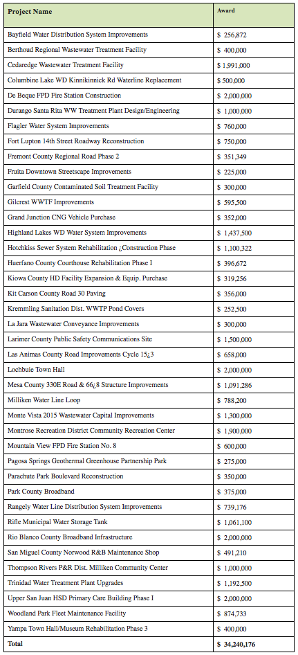
Maintain the big flows on the Colorado River tied to the Shoshone hydro plant.

Upgrade the roller dam on the Colorado east of Grand Junction.

And figure out how much water the rivers and streams in the region need to stay healthy.

Those are the top three basinwide priorities of the Colorado River basin roundtable, a water-supply planning group working under the auspices of the Colorado Water Conservation Board.

The roundtable is finalizing a “basin implementation plan” for the Colorado River Basin, which stretches across the state from Grand County to Grand Junction.

Other projects in the plan include enlarging Hunter and Monument reservoirs on Grand Mesa, building a new reservoir on lower Homestake Creek near Camp Hale and constructing Kendig Reservoir on West Divide Creek south of Silt.

The roundtable’s plan and project list are due to the state by April 17, as are plans from seven other basin roundtables. The basin plans will inform the Colorado Water Plan, which is to be presented to the governor in December.

A draft plan submitted by the roundtable in the summer listed more than 400 potential projects, plans and processes. State officials asked the roundtable to prioritize its list.

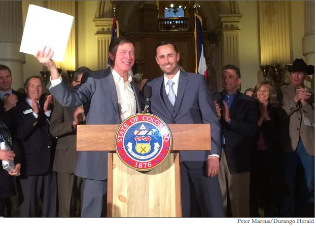
Roundtable members presented their top projects at a March 23 meeting. It was the group’s last meeting before the April 17 deadline.

“Being listed is not a ticket to reality,” said Jim Pokrandt, the chairman of the roundtable and the communications director for the Colorado River District. “There will be other ideas, projects and processes not yet known to us that might be better, more feasible candidates.”

KEEPING THE BIG CALLS

Securing the flows tied to the Shoshone hydropower plant is a clear priority for the roundtable.

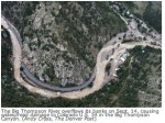
The plant, just east of Glenwood Springs, has senior rights from 1902 and can demand that 1,200 cubic feet per second of water be sent downriver to produce hydropower.

The facility is owned by Xcel Energy, which firmly said a year ago that the facility was not for sale to either Western Slope nor Front Range entities. Nonetheless, the Colorado River District is working to maintain the flows created by the plant, either by buying it outright or making other arrangements with Xcel.

Downriver, the Grand Valley Diversion Dam in DeBeque Canyon near Cameo provides water to the four entities that make up the senior Cameo call. The 100-year-old riverwide structure directs 1,332 cfs of irrigation water into the 55-mile-long Highline Canal.

Both the dam and the upper portion of the canal are in need of “extensive upgrading and rehabilitation,” according to a project sheet distributed by the roundtable.

“The Shoshone Call and the Cameo Call are the two main calling rights on the Colorado River, and the whole regime of the river has developed over the years based on these two calls being in place,” said Mark Hermundstad, an attorney from Grand Junction who represents Mesa County on the roundtable. “Both of those calls draw down clean high-mountain water to the middle and the lower reaches of the river, and we think it is important to maintain those flows down the river.”

A third roundtable priority is the development of a basinwide stream-management plan to “help resource managers better understand and manage streamflows” for both ecological and recreational reasons.

NEW AND EXPANDED RESERVOIRS

Among the sub-basin projects put forward are the enlargement of both Hunter and Monument reservoirs in the Plateau Creek drainage on Grand Mesa, about 20 miles southeast of Collbran.

The Ute Water Conservancy District, which provides water to the Grand Junction area, is proposing to enlarge Hunter Reservoir from 100 acre-feet to 1,340 acre-feet, at a cost of $5 million to $7 million.

The existing 11-foot-tall dam would grow to 37 feet, the reservoir’s surface area would expand from 19 to 80 acres, and it would inundate 32 acres of wetlands, according to a 2007 study by the U.S. Forest Service.

Monument Reservoir No. 1, on Monument Creek south of Vega Reservoir, would be expanded from 573 to 5,255 acre-feet. A new dam would be 69 feet tall and would flood 145 acres. The cost estimate is $20 million, according to Steve Ryken, assistant general manager of Ute Water, who sits on the roundtable.

Another significant sub-basin project is the Eagle River MOU, a 1998 agreement to develop 33,000 acre-feet of new water storage. Of that, 20,000 acre-feet would eventually flow east to Aurora and Colorado Springs, and 10,000 acre-feet would be for use in the Eagle River watershed.

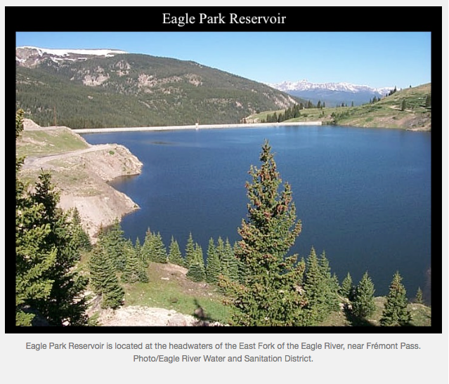
Project components being actively studied include the expansion of Eagle Park Reservoir from 3,300 acre-feet to 8,000 acre-feet or more and the construction of a new reservoir on lower Homestake Creek, near Whitney Creek, that would hold 3,500 to 10,000 acre-feet of water.

“Currently, the project sponsors are continuing investigations to evaluate the ‘Whitney Creek’ alternative, consisting of a surface diversion from the Eagle River to the area of Camp Hale with a dual-purpose storage reservoir/pumping forebay on Homestake Creek to store West Slope yield, and regulate and feed East Slope yield up to Homestake Reservoir,” states a May 2014 draft of the basin plan.

Also on the list is the building of 257-acre Kendig Reservoir on West Divide Creek, 15 miles south of Silt.

ROARING FORK PROJECTS

Two priority projects, or processes, were identified in the Roaring Fork River watershed, according to Mark Fuller, the executive director of the Ruedi Water and Power Authority and a legislative appointee to the Colorado roundtable.

One priority is an ongoing process led by the Roaring Fork Conservancy to find ways to leave more water in the lower Crystal River, which is heavily diverted for agriculture.

The second priority project is the completion of the 210 action items identified in the 2012 Roaring Fork Watershed Plan, which does not include significant new water-storage projects.

“It’s not like we’re really suggesting that we do 210 projects. We’re suggesting we carry out the watershed plan, including the nine priority projects already identified in the plan,” Fuller said.

Fuller said he did not expect that supporting the city of Aspen’s conditional water rights for large dams on upper Castle and Maroon creeks would be added as a third project for the Roaring Fork sub-basin, as Mike McDill, the deputy utilities manager for the city of Aspen, has lobbied for.

PRIORITIES BY REGION

In the Middle Colorado region, between Dotsero and DeBeque Canyon, the priorities are, in addition to building Kendig Reservoir, investigating the sources of selenium in Mamm and Rifle creeks, studying the feasibility of a regional water authority to serve Silt Mesa and surveying the region’s irrigation assets.

In the State Bridge region, between Kremmling and Dotsero, the priorities are to designate Deep Creek as a “wild and scenic” river and to inventory irrigation systems around Eby, Brush and Gypsum creeks.

In the Grand County region, the priorities are to repair and restore 10 miles of the Colorado River near Kremmling, update the existing $1 million Grand County stream-management plan and expand a water-district reservoir near Fraser by 80 acre-feet.

In Eagle County, in addition to the Eagle River MOU projects, the priorities include restoring 270 acres of wetlands at Camp Hale to be used for future wetland mitigation credits and five water-quality projects, including one on Gore Creek as it flows through Vail.

In Summit County, the top priorities are to enlarge by 500 acre-feet the Old Dillon Reservoir, a small reservoir next to Dillon Reservoir, restore a 3,000-foot-long stretch of the Blue River in Breckenridge and modify Dillon Reservoir to let warmer water be released back into the Blue.

The third key project in the Grand Valley region, after enlarging Hunter and Monument reservoirs, is the repairing of the Southside Canal owned by the Collbran Water Conservancy District.

The canal was built in the 1950s and has at least two siphon pipes that need replacing. It can normally carry 240 cfs of water and winds 33 miles from Vega Reservoir to Mesa Creek.

Editor’s note: Aspen Journalism is collaborating with The Aspen Times and the Glenwood Springs Post Independent on coverage of Colorado rivers and water. More at http://www.aspenjournalism.org.

More Colorado Water Plan coverage here.

The Fountain Creek District is focusing on maximizing SDS payments from Colorado Springs

Southern Delivery System route map -- Graphic / Reclamation
Southern Delivery System route map — Graphic / Reclamation

From The Pueblo Chieftain (Chris Woodka):

Big money for flood control on Fountain Creek would become available in January the year after Southern Delivery System begins delivering water.

But the district that will receive the $50 million in payments over five years wants to make sure the money is safe from Taxpayer’s Bill of Rights legislation that could erode the funds.

Most likely, the money would begin arriving in 2017, provided that Colorado Springs meets all conditions of its agreement with Pueblo County.

Last week, the Fountain Creek Watershed Flood Control and Greenway District board asked Pueblo County commissioners and Colorado Springs Utilities to amend the 1041 agreement on SDS to make payments to its newly created enterprise, rather than the district. The resolution passed 9-0.

“The money has to be redirected so we can comply with the TABOR spending limit,” Executive Director Larry Small explained.

The money has to be spent on flood control projects that directly benefit Pueblo County, and the district has studies in progress to determine what sort of projects it could be applied.

The Fountain Creek district is looking at a dam or detention ponds between Colorado Springs and Pueblo to reduce the damage from large floods. It is also tackling the questions of impacts of temporary storage on water rights raised by farmers downstream on the Arkansas River.

TABOR puts limits on how much spending can increase by publicly funded entities in Colorado, year over year. Small gave his board projections that showed the full $50 million would not be available. The district intends to use the money to leverage other sources of payment.

Conservancy districts, including Southeastern and the Lower Ark, have long used enterprises to deal with funds collected and spent on top of property taxes. Under state law, the Fountain Creek district can assess up to 5 mills in property tax with voter approval, but it has never approached voters in El Paso and Pueblo counties to initiate any tax.

More Fountain Creek coverage here.

Poem: I am not alone — Greg Hobbs

I am not alone

iamnotalonegreghobbs03292015

I am with you

iamwithyougreghobbs03292015

Paths we live along

pathswelivealonggreghobbs03292015

I walk with you

iwalkwithyougreghobbs03292015

I follow you

ifollowyougreghobbs03292015

Sometimes lose a head gate wheel

sometimesloseaheadgatewheelgreghobbs03292015

Sometimes paddle storm drain pools

somtimespaddlestormdrainpollgreghobbs03292915

A new march.

anewmarchgreghobbs03292015

Greg Hobbs, March 29, 2015. Reprinted with permission.

Update on the new hydroelectric generation station at the north outlet works at Pueblo Dam

The new north outlet works at Pueblo Dam -- Photo/MWH Global
The new north outlet works at Pueblo Dam — Photo/MWH Global

From The Pueblo Chieftain (Chris Woodka):

It will be awhile before the turbines start spinning, but work continues toward installing hydroelectric generation at Pueblo Dam.

An update on the hydropower project was shared by Kevin Meador of the Southeastern Colorado Water Conservancy District staff at this month’s board meeting.

“We’re working with Black Hills Energy on the pricing of power and what we sell it for. That’s a key piece, and we’re getting close to the nitty-gritty,” Meador told the board.

The district is working with Colorado Springs Utilities and the Pueblo Board of Water Works on a 7-megawatt generation system that would be installed at the North Outlet Works on Pueblo Dam.

The structure was built as part of the Southern Delivery System with design allowing for future hydro connection. It would generate about 20,000 megawatt hours annually and could be completed by 2018.

The total cost of the project is in the $20 million range, and so far about $934,000 has been expended in engineering work.

In January, the Pueblo County planning commission issued a finding of no significant impact and the U.S. Bureau of Reclamation decided an environmental assessment would be needed. Black Hills completed an interconnection study in December and recommended hooking up to the grid at a newly constructed substation which will serve the SDS Juniper Pump Station.

More Southeastern Colorado Water Conservancy District coverage here.

State ditches well plan — The Pueblo Chieftain

Straight line diagram of the Lower Arkansas Valley ditches via Headwaters

From The Pueblo Chieftain (Chris Woodka):

The Colorado Division of Water Resources last week dropped plans to institute new well rules for Arkansas River basin.

The rules would have applied to appropriations of groundwater after 1985, when Kansas sued Colorado in the U.S. Supreme Court over groundwater appropriations. The state was not interested in pursuing the rules if water users thought them unnecessary.

“There wasn’t a consensus that it was needed,” said Division 2 Engineer Steve Witte.

A survey of ditch company officials, water attorneys and other interested parties was mixed with 39 percent favored new rules, 32 percent opposed and 29 percent neutral. Survey results were posted online.

Under current rules, new appropriations for wells must have a court-approved augmentation plan or can be approved temporarily under a substitute water supply plan.

More Arkansas River Basin coverage here.

Pueblo County water rights buy: “This meets all the charges the district has” — Terry Hart

Fountain Creek Watershed

From The Pueblo Chieftain (Chris Woodka):

Pueblo County is angling to become the owner of the most senior water rights on Fountain Creek.

The purchase would be aided by the Fountain Creek Watershed Flood Control and Greenway District, which voted Friday to line up financing for the deal, which is expected to complete by the end of the year.

“I see this as a fascinating project. This meets all the charges the district has: flood control, recreation, restoration and conservation,” Commissioner Terry Hart said. “I love history. I’m thrilled with it.”

The Greenview Trust property, located 8 miles north of Pueblo along Overton Road, is about 360 acres with water rights dating back to 1862. Like other farms on Fountain Creek, it has faced erosion issues for years, and the owners sued the city of Colorado Springs after the 1999 flood over the growth that increased the base flows in the waterway.

Negotiations are still underway for the purchase of the property and details cannot be discussed publicly, Hart said.

“We still have some due diligence issues,” Hart said.

The county has some other water rights, but the Fountain Creek purchase would give it more legal standing on water rights issues as projects develop along Fountain Creek.

The Fountain Creek district board voted 9-0 to line up some of the financing for the possibly $3.72 million project in open session Friday, since public grants and loans are involved.

Collateral for the $1 million loan from the CWCB would be the upcoming payments by Colorado Springs Utilities to the Fountain Creek district under the 1041 permit with Pueblo County. The first payment would come due in early 2017, if the Southern Delivery System goes online by 2016, as expected.

The property could be used for wetlands or for detention facilities that would aid flood control.

Pueblo County intends to put a conservation easement on the property as well because of its historic significance, Hart said.

“This is exactly what we want to be doing as a district,” said Richard Skorman, who sits on the Fountain Creek board.

“The Lower Ark is obviously excited about this,” said Melissa Esquibel, a Lower Ark board member who sits on the Fountain Creek board.

Board member Jane Rhodes, a Fountain Creek landowner, is related to the family which is selling the property.

Managers: #Drought could go 15 years — the Cortez Journal #ColoradoRiver

Douglas Fir tree rings via the Western Water Assessment

From the Cortez Journal (Jim Mimiaga):

Water managers at the Ag Expo explained water issues through the lens of a drought that’s lingered in the region since 2000.

In some ways, things have worked out as they should, said Eric Kuhn, of the Colorado River Conservation District.

“Our reservoirs have done what they are supposed to do by storing water for when we really need it,” he said. “The worry is how long the drought will continue.”

Trends show there will be less water in the future. Tree-ring data show that between 760 AD and 2005, wet periods and dry periods each last 30 years.

“We could be faced with another 15 years of drought based on that trend,” said water engineer Steve Harris.

Population adds to the stress. Currently, the Colorado River Basin serves 35 million people, and irrigates 5.5 million acres.

“The future shows it going to 80 million people and 4.6 million acres of farmland,” Kuhn said.

More Colorado River Basin coverage here.

Snowpack news: Recent weather brings Yampa/White watersheds back up to 2002 levels

Mosca wastewater project progressing — the Valley Courier

Wastewater Treatment Process

From the Valley Courier (Phil Ray Jack):

Alamosa County Commissioners (ACC) received an update on the Mosca Wastewater Infrastructure Improvement Project Wednesday.

“The project is moving forward,” Rachel Baird reported , “and we are in the process of applying for the additional funding it will take to complete it.”

In January, the commissioners approved a $1.4 million plan for a new wastewater treatment system in Mosca. For years now, the small community located in northern Alamosa County has wrestled with a failing sewage system and the threats to public health caused by it.

According to some reports , the system has been in disarray for two nearly two decades, threatening residents’ health because the sewage is not being adequately treated before being discharged, and leaching into the area surrounding existing septic tanks. Seven of the 10 septic/leach fields systems have wells located within the minimum 100 foot setback distance, which makes them highly susceptible to contamination.

A preliminary engineering report describing the proposed system had been presented to the county during a previous meeting. Mosca’s new wastewater system will consist of three parts: a collection system, a wastewater treatment facility and a discharge system.

Ken Van Iwarden, who is representing Alamosa County in the process, explained that groundwater tests were conducted on March 17 by the Colorado Water Association. The results will not be known but will provide more information that will help with determining what type of system will be appropriate for the project.

Until the project is completed , the county will continue to regularly pump the failing system because there is no other option, costing county taxpayers upwards of $50,000 annually.

More wastewater coverage here.

Capturing the Eagle River’s last drops for those dry, hot summers ahead — The Mountain Town News

eagleparkreservoirviamountaintownnews

From The Mountain Town News (Allen Best):

Expansion of Eagle Park Reservoir and other storage options studied

The summer of 2002 was so hot and dry in Vail that when a rainstorm finally arrived in August, people violated the idiom about common sense and stood and then danced outside in the pouring rain.

In the offices of the local water provider, Eagle River Water & Sanitation District, Linn Brooks remembers worries that Gore Creek—the primary source of Vail’s water, via wells that draw from the creek’s alluvial aquifer—might disappear altogether. Droughts from the 20th century had never been as severe.

September rains in 2002 eased immediate concerns. But 13 years later, water district still seeks to steel itself from a return of drought that severe—or worse.

Twice, upstream reservoirs have been expanded modestly and wells were drilled downstream at Edwards at a cost of several million dollars.

Now comes discussion of a much more ambitious expansion of Eagle Park Reservoir, one of several ideas for increased storage of the final waters of the upper Eagle Valley.

Eagle Park Reservoir is along the East Fork of the Eagle River, near Frémont Pass, about 20 miles south of Vail. It was built in the 1960s to hold tailings from the nearby Climax molybdenum mine. Then, in the mid-1990s, it was cleaned up and converted to water storage beginning in 1998.

Expanded minimally in 2009 at a cost of $250,000, it can now store a maximum of 3,300 acre-feet of water. The idea now being reviewed would expand storage to between 6,000 and 9,000 acre-feet.

Brooks, now the general manager for the water and sanitation district, says the project would address future population growth in Vail and the Eagle Valley, provide water to meet minimum streamflow water rights and, somewhat more nebulously, deliver water to mitigate water quality problems and benefit the river ecosystem.

But the essential driver, says Brooks, is the potential for intensified drought. Before the drought of 2002, the worst year on record was 1977 and local water planners tried to plan for three years of consecutive drought of that magnitude.

Now, they’re trying to plan for three consecutive years as bad as 2002.

“I would say we are still reacting to 2002,” says Brooks.

But stacked up behind the fresh and concrete evidence of 2002 is the worrisome potential for even more intensified drought such as occurred around 800 to 1300 AD.

Tree rings in the Colorado River Basin—including some from trees near Eagle—provide evidence of those droughts. A recent study calculated that such droughts have a 66 percent chance of occurring in the 21st century.

naturalflowbouldercreeknearorodelltreeringsviamountaintownnews

On top of this comes the effect of accumulating greenhouse gas emissions. Climate models have drawn no clear conclusions about effects of precipitation in places like Vail, they are clear in warning of hotter, longer summers and, when it occurs, more intense drought.

Of course, river flows have always been variable on the Eagle and other river basins of the Southwest. Since the record-shattering drought of 2002, points out Brooks, Vail has also had a once-in-100 years runoff. Precipitation in the high Rockies, she points out, has “extreme variability.”

Memorandum of understanding

The Eagle River has three significant reservoirs at its headwaters:

• Black Lakes, located at Vail Pass, at the headwaters of Black Gore Creek, which can hold 750 acre-feet.

• Homestake Reservoir holds 14,000 acre-feet, but only 1,000 acre-feet can be used for Western Slope purposes. The rest is diverted for use by Aurora and Colorado Springs.

• Eagle Park Reservoir is the newest. In the early 1990s, water attorney Glenn Porzak, of Porzak, Browning Bushong, initiated discussions with Climax about converting assets of the mine to accommodate the growing needs of his clients in Vail for water storage. He represents Vail Resorts, and Eagle River Water and Sanitation District as well as the parallel Upper Eagle River Water Authority.

The consortium was expanded to include Eagle County, the Glenwood Springs-based Colorado River Water Conservation District, and owner of the mine, which is now FreeportMorgan. Climax paid to clean up the reservoir at a cost of $12 million.

But Aurora and Colorado Springs also own substantial water rights in the basin. In the 1960s, they joined to build Homestake Reservoir. In the 1980s, they proposed to further expand the water collection system within the Holy Cross Wilderness Area. The project was called Homestake II.

Eagle County thwarted that ambition. Its 1987 denial survived court challenges and statehouse attempts to yank the legal rug from under the local government.

The River District convened discussions that recognized that the water rights of the Front Range cities must be recognized—but, in developing the water, the Western Slope must benefit, too. The Eagle River memorandum of understanding inked in 1998 identifies 30,000 acre-feet of water in the Eagle River Basin to be developed in thirds: for Aurora, Colorado Springs, and the Western Slope.

Even if Eagle Park gets expanded, it’s unlikely to be the only project, says John Currier, chief engineer for the Colorado River Water Conservation District.

“It’s very likely that you can’t develop the water in the Eagle River MOU in one single project. I think it’s more accurate to say it’s one project with multiple components.”

gorecreekvailgolfcourse2002mountaintownnews

Another long-discussed idea is a small reservoir in the Homestake Valley near the Blodgett Campground. Still another is a holding facility, called a forebay, in the same valley, along Whitney Creek, that would hold water pumped back from Camp Hale. From this impound water could be further pumped up the valley to Homestake Reservoir. Yet a third idea is a small reservoir on Red Sandstone Creek, north of Vail.

Benefits of Eagle Park, says Currier, are that it already exists, it’s on private property, eliminating need for the high level of environmental review that other projects on public land would require, and the property has already been disturbed.

The latter is a persuasive argument to Ken Neubecker, a representative of American Rivers, a conservation group.

“Without looking at the details, I would think favorably of it. Eagle Park Reservoir was an old tailings pile to begin with. It wasn’t like ripping up an undammed valley like Blodgett Reservoir would. Adding onto it would be the best use of facilities we already have.”

Expanding Eagle Park, however, will likely be expensive. No cost estimates have been delivered, but Brooks says it’s something “we cannot do on our own. We would have to have partners in a project like that.”

Porzak says Aurora could benefit by storing water from the Columbine Ditch, a water diversion across Tennessee Pass, in the reservoir.

Energy use also is problematic. The reservoir has almost no upstream. Water would have to be pumped 150 vertical feet from the East Fork of the Eagle River, says Porzak.

A small reservoir at Whitney Creek would also require pumping water, says Currier. But for diversions to the Front Range, going farther down the Eagle River is even more challenging.

Scenario planning

Exactly what would best benefit the Vail Valley is still unclear. Brooks has turned to a tool called scenario planning that is used by Denver, Seattle and many other water planners. It tries to calculate a whole range of variables, including population growth and climate change. Expanded storage is only one of the responses. “Basically, conservation and optimization should be applied first,” says Brooks.
Expanded storage, however, will ultimately be necessary for a variety of purposes. “I don’t think we will ever be able to conserve our way out of needing an expanded Eagle Park Reservoir,” she says.

While needs of population growth can be met relatively easily, Brooks sees need to provide broader but somewhat more nebulous environmental and aesthetic benefits.

“It’s always been a little harder for our boards to wrap their heads around paying for the aesthetics in the streams,” she says. “They’ve certainly gone there in the past, paying literally millions to ensure the stream flows for health.”

Making that case is becoming easier. Water quality impacts from urbanization and other development impacts have become documented, and state water quality standards have tightened. As nutrients get washed into the waterways from stormwater, the capacity of the river gets whittled away, Brooks explains.

There seems to be no rush by anybody to build anything quickly. But there is a sense that the decisions made need to be very good. Unless the climate changes to produce more snow and rain, the upper basin will be without additional water to develop. Downstream, there could be more, but not at the headwaters.

“If it’s not the last drop, it’s darned close to the last drop in the Eagle, because you’re just physically constrained by what you can develop,” says the River District’s Currier.

Going farther downstream, as has been discussed with such “big straw” projects as the Yampa River pumpback or Flaming Gore pumpback, remains possible, adds Currier, but “at that point your energy costs are hugely significant.”

More Eagle River watershed coverage here.

Eagle River Basin
Eagle River Basin

2015 Colorado legislation: Governor Hickenlooper signs HB15-1144 (Prohibit Plastic Microbeads Personal Care Products)

Graphic via 5Gyres.org

From TheDenverChannel.com:

Gov. John Hickenlooper has made Colorado the third state to ban on tiny plastic particles from soaps and cosmetic products.

In May 2014, the CALL7 Investigators were first to expose concerns over microbeads in Colorado water. That investigation confirmed the plastic particles — which are found in some toothpastes, face washes, body washes, shampoos, eyeliners, lip glosses and deodorants — had made their way through state filtration systems and into the South Platte River. The CALL7 Investigators sent water samples from the South Platte to a specialized lab in Marietta, Ga., which found microbeads made of polypropylene, a type of plastic. The toxic particles can be consumed by fish, and ultimately, by humans.

The bill signed into law Thursday bans microbeads by 2020.

The ban has the backing of large personal-care product manufacturers including Johnson & Johnson.

Illinois and New York have already enacted bans, and other states are considering bans.

More 2015 Colorado legislation coverage here.

Montrose: Gunnison Basin Roundtable urges public input to the #COWaterPlan, April 6

Gunnison River Basin via the Colorado Geological Survey

From the Ouray County Plaindealer (Bill Tiedje):

Members of the Gunnison Basin Roundtable are urging the public to attend a scoping meeting on April 6 at 7 p.m. at the Holiday Inn Express in Montrose to make suggestions or comments regarding the Gunnison Basin Implementation Plan.

Tri-County Water Conservancy District’s GBR representative Mike Berry explained the BIP will become a part of the Colorado Water Plan.

“The BIPs are the critical information in the state water plan in my opinion,” Berry said.

Berry said the meeting will offer the public a chance to learn more about the Gunnison BIP, including strategies and opportunities for water use in the basin.

“It’ll be an opportunity to ask questions and give feedback,” Berry explained.
Public comments will be considered as GBR representatives finalize the BIP before submission to the Colorado Water Conservation Board.

The BIPs will then be incorporated into the CWP, which is scheduled for completion in December 2015.
Berry said, “The whole idea behind the Roundtable process is a bottom-up strategy.”

The BIP has identified a number of potential water projects in the basin, including upper basin portions of Ouray County, but Berry said federal funding is currently lacking to make large projects a reality.

“I think our solutions are going to come from other directions,” Berry said, suggesting conservation or demand management water strategies may be more feasible in the near term.

Ridgway and Ouray GBR representative Joanne Fagan said the goal of the BIP process is to determine strategies to meet the water needs of the state.

Fagan agreed that conservation is the “low hanging fruit” to meet growing municipal and industrial water needs.

Fagan said members of the public can read the Gunnison BIP online at http://www.coloradowaterplan.com and can find a list of potential projects under Table 7 in the document.

She described the upcoming meeting as a “more global process” looking at ways to address perceived shortfalls without drastically changing ways of life in Colorado.

According to a March 18 press release, “The GBR was formed by statute in 2005, under the Colorado Water for the 21st Century Act; it is one of nine roundtables in Colorado, charged to ‘encourage locally driven collaborative solutions to water supply challenges,’ assess ‘basin-wide consumptive and non-consumptive water supply needs,’ and ‘serve as a forum for education and debate regarding methods for meeting water supply needs,’ according to Colorado Governor’s Office.”

The GBR consists of 32 members representing local governments of the basin and other environmental, industrial, agricultural and recreational interests.

“To encourage locally-driven and balanced solutions to water supply challenges, the plan identifies water projects through targeted analyses of water issues in the basin,” the press release stated. “The BIP includes analyses of water shortages, water availability under variable hydrologic conditions, and various site-specific water supply issues. The ultimate purpose of the plan is to better identify priority needs in the basin and highlight proposed projects that will excel at meeting these needs in the future.”

Uncompahgre Watershed Partnership Coordinator Agnieszka Przeszlowska said her organization is helping to promote the event.

Przeszlowska said, “The BIPs are an opportunity for anyone in the Uncompahgre Basin to provide input on needs or projects that they see value in.”

Summary information regarding the Gunnison BIP will be posted on http://www.uncompahgrewatershed.org/events prior to the April 6 meeting.

More Colorado Water Plan coverage here.

#Drought news: Four Corners, drought worsened in the northwest, while conditions improved somewhat in southeastern portions of the region

Click here to go to the US Drought Monitor website. Here’s an excerpt:

Summary
Rain across southern-most portions of the nation provided drought relief, while dry weather maintained or worsened drought from California into portions of the Rockies, Plains, and Upper Midwest. In addition, above-normal temperatures further reduced already-dire mountain snowpacks over much of the West and accelerated pasture and crop-water demands in the nation’s mid-section. Dryness also increased in the Northeast, though below-normal temperatures mitigated the impacts of the precipitation deficits…

Central Plains
Dry, unseasonably warm weather maintained or worsened drought over the central Plains. With temperatures approaching or topping 80°F from southeastern Colorado into Kansas as well as little if any rain, drought conditions remained or intensified. In particular, pronounced short-term dryness (25 to 50 percent of normal over the past 90 days) across central and southern portions of Kansas supported the expansion of Moderate (D1) to Severe Drought (D2). Soil moisture continued to decline, and many streamflows were in the 10th percentile or lower…

Northern Plains
Despite pockets of light rain, unseasonable warmth (up to 10°F above normal) coupled with increasingly dry conditions over the past 90 days led to the expansion of Abnormal Dryness (D0) and Moderate Drought (D1) in the western Dakotas. Over the past 90 days, precipitation has totaled 60 to 75 percent of normal (locally less) in the newly-expanded D0 areas of the northern Plains, while the D1 area of South Dakota has received less than 50 percent of normal precipitation. The dryness coupled with rapid snow melt and temperatures well into the 70s in South Dakota have accelerated water demands for emerging pastures and greening winter crops. In addition, reports from the field indicate dry soils are becoming an underlying issue…

Southern Plains and Texas
Worsening drought in the north contrasted with heavy rain and drought reduction in the south. Across Oklahoma and northern Texas, most areas received less than 0.5 inch of rain during the monitoring period, which coupled with daytime highs in the upper 70s and lower 80s (degrees F) afforded no relief from drought. In areas where rain was sparse or non-existent, Severe to Exceptional Drought (D2-D4) expanded as streamflows continued to decline well below the 10th percentile. Soil moisture likewise rapidly diminished as the unseasonable warmth increased crop- and pasture-water demands. Meanwhile, moderate to heavy rain (1 to 4 inches) from southern Oklahoma into central and southern Texas reduced drought coverage and intensity, with the most notable improvements occurring between San Antonio, Texas, and the Big Bend. Despite the soaking rainfall, little change was made to the drought coverage and intensity northwest of Austin, where reservoirs levels struggled to rebound due to a persistent, pronounced long-term drought…

Western U.S.
The overall trend toward drought persistence or intensification prevailed, with relief confined to a few scattered locales in the Four Corners Region and southeastern California. The west continued to cope with much-above-normal temperatures, further depleting already-dire snowpacks and reducing spring runoff prospects over much of the region.

In the north, a steady influx of Pacific moisture and weekly average temperatures up to 7°F above normal resulted in moderate to heavy showers from the Cascades into the northern Rockies. However, plentiful water-year precipitation (since October 1) in the Northwest was in sharp contrast to virtually non-existent snowpacks, with the snow-water equivalents less than 25 percent of normal (locally less than 10 percent) across Oregon as well as southern and northwestern Washington. The lack of snow maintained concerns for spring and summer water supplies despite the generally favorable 2014-15 water year.

In the Four Corners, drought worsened in the northwest while conditions improved somewhat in southeastern portions of the region. In particular, Severe to Extreme Drought (D2-D3) expanded over northern Utah to account for water-year precipitation averaging 30 to 45 percent of normal; the Standardized Precipitation Index (SPI) – a measure of drought severity – depicted values at or below -1.75 (D3 equivalent) in this same area . In addition, snow-water equivalents southeast of the Great Salt Lake were near or below 50 percent of normal (3-10th percentile). In New Mexico, however, improving conditions were noted in the southern Rockies, where locally more than an inch of rain and high-elevation snow afforded relief from Moderate Drought (D1).

In California, changes to this week’s depiction were generally minor as the state entered a fourth consecutive year of drought. Locally more than an inch of rain was noted in the Cascades and in the Coastal Range, but the moisture fell well short of supplying drought relief. Even with this week’s rain, precipitation deficits over the past two weeks exceeded 2 inches in these same locales. In the D4 areas of the Cascades and southern San Joaquin Valley, water-year precipitation has averaged 30 to 50 percent of normal, and locally less than 50 percent of normal over the past 3 years. Short-term moisture has been somewhat more plentiful in northern California, though even areas north of Sacramento are dealing with significant long-term precipitation deficits (70-75 percent of normal over the past three years) that will take considerable time to erase. Despite the generally worsening conditions, a small reduction in Extreme Drought (D3) was made in southeastern California’s Mojave Desert, where the wildflower bloom has responded favorably to showers…

Looking Ahead
Warm, mostly dry weather over the west will contrast with chilly, wet conditions east of the Mississippi Valley. The greatest likelihood for drought-easing rainfall will be from Texas and the northern Delta into the Northeast. Spotty showers are expected over the Rockies and Northwest, though the light rain coupled with persistent warmth will not ease drought or aid spring runoff prospects. Mostly dry, warm weather is expected over California and the Southwest. The NWS 6- to 10-day outlook for March 3 – April 4 calls for near- to above-normal temperatures nationwide, except for colder-than-normal conditions across the nation’s northeastern quadrant. Meanwhile, above-normal precipitation from the northern Plains and Upper Midwest into the Great Lakes and Northeast will contrast with drier-than-normal conditions in the south, particularly from California into the Four Corners and southern Plains.

From Arizona Republic:

The National Oceanic and Atmospheric Administration forecast predicts drought will persist or worsen in Arizona, California, Nevada, Oregon and western Colorado through June.

“Periods of record warmth in the West and not enough precipitation during the rainy season cut short drought relief in California this winter, and prospects for above-average temperatures for this spring may make the situation worse,” said Jon Gottschalck, with NOAA’s Climate Prediction Center.

Arizona, California, Nevada, Utah and Washington had their warmest winters on record, Gottschalck said.

Above-average temperatures are expected to continue this spring in the Far West and northern Rocky Mountains.

Above-average precipitation is predicted for parts of the Southwest and the southern and central Rockies.

The above-average precipitation predicted for Colorado over the next three months could reduce drought conditions in the southeast part of the state. The moisture could ease the fire season, Gottschalck said, but also could increase undergrowth that worsens the situation…

Thursday’s NOAA spring forecast is the most recent in a series of grim reports on the drought.

Last month, scientists from NASA and Columbia and Cornell universities published a study predicting a better than 80 percent chance of a “megadrought,” one lasting at least 35 years, hitting the Southwest and central Great Plains in the second half of this century.

From KJCT8.com (Makenzie O’Keefe):

The United States Drought Monitor is claiming Western Colorado is currently undergoing a moderate drought, but the National Weather Service disagrees – saying we aren’t seeing those effects just yet.

According to the Drought Monitor, a moderate drought means there can be some damage to crops or streams, as well as some water shortages developing.

The National Weather Service says within the past few months we have actually seen more precipitation here in Grand Junction than in past years.

That being said, snowpack levels right now are showing that we are trending towards more of a drought in upcoming weeks which could be more dangerous.

Weekly Climate, Water and Drought Assessment of the Upper #ColoradoRiver Basin

precipitation0301thru03222015

Click here to read the current assessment. Click here to go to the NIDIS website hosted by the Colorado Climate Center.

More Colorado River Basin coverage here.

Snowpack news: Aspen snowpack dust-free for first March in a decade — The Aspen Times

Westwide SNOTEL snow water equivalent as a percent of normal March 25, 2015 via the NRCS

From The Aspen Times (Scott Condon):

The Center for Snow and Avalanche Studies, a nonprofit organization based in Silverton, said no dust has been observed at 11 high-elevation sites that it monitors around the state, including McClure Pass on state Highway 133. The organization has operated the Dust-On-Snow Program since 2005.

Last winter, there were three major dust storms at the Senator Beck Basin, a sentry site for the organization in the San Juan Mountains. The dust affected many other sites, as well. Skiers at the Aspen-Snowmass ski areas negotiated a red layer of grit on the snow.

The dust does more than mess up the slopes. It reduces the reflective ability of the snowpack, said Chris Landry, a former Roaring Fork Valley resident who is executive director of the Center for Snow and Avalanches. Clean snow reflects solar energy from the sun pretty effectively, he said. Dust is “the 800-pound gorilla” because it absorbs the sun’s energy and the snowpack melts more quickly.

“That’s why dust is so important — it completely alters the absorption,” Landry said.

The snowpack isn’t in the clear yet. History shows that dust gets deposited in April and May, as well. Spring storms on the Colorado Plateau blow in dust from the south and west of Aspen. When accompanied by rain or snow, it sometimes creates a scenario where it rains mud.

The snowpack — the lifeblood for much of the arid West — needs any break it can get this year. The overall snowpack level for the Upper Colorado Basin, which covers much of the Central Mountains, is 89 percent of average for this time of year, according to the U.S. Natural Resources Conservation Service.

Not only is the snowpack below average, but it is already substantially eroded on sunny slopes on east, west and south aspects, Landry and his colleagues discovered on a tour of the center’s 11 sites March 17 through Friday. Lower elevations are already melted out in many areas, according to an update on the center’s website.

In addition, the center found that the snowpack has ready warmed to 0 degrees Celsius in many places. That means any energy consumed by the snowpack will result in melting rather than cooling the layers down.

“People refer to this as a ripe snowpack,” Landry said. “Just add energy and you’ll get water.”

How the warming climate is transforming your garden: Planting zones are marching northward — @AssaadRazzouk

$1.5 Million Contract Awarded to Repair Colorado-Big Thompson Infrastructure Damaged by 2013 Flooding — Bureau of Reclamation

The Big Thompson River September 14, 2013 via The Denver Post

Here’s the release from the Bureau of Reclamation (Tyler Johnson):

The Bureau of Reclamation has awarded a contract totaling nearly $1.5 million to Lillard and Clark Construction Company Inc., Denver, for repair to the Big Thompson Diversion Structure, an element of the Colorado-Big Thompson project that was damaged during the September 2013 flood, known as one of the worst natural disasters in Colorado history.

“Reclamation is addressing the infrastructure damage that occurred during the 2013 Colorado River flooding,” said Reclamation Commissioner Estevan López, while announcing today’s $1,457,570 contract award. “This work will ensure the project’s continued reliability.”

Big Thompson Diversion Structure, located 8.5 miles west of Loveland, Colorado, in Larimer County, requires removal and restoration of flood-damaged concrete areas, installation of a precast concrete building, repair and replacement of electrical systems, gates, gear boxes, electric motors and other rehabilitation tasks. The work is expected to begin in April 2015.

The Colorado-Big Thompson project spans approximately 250 miles in Colorado. It stores, regulates and diverts water from the Colorado River on the western slope of the Continental Divide to the eastern slope of the Rocky Mountains, providing supplemental water to irrigate about 720,000 acres of land for municipal and industrial uses, hydroelectric power and water-oriented recreation opportunities. Major features of the project include dams, dikes, reservoirs, power plants, pumping plants, pipelines, tunnels, transmission lines, substations and other associated structures. The Northern Colorado Water Conservancy District apportions water used for irrigation to more than 120 ditches and 60 reservoirs. Eleven communities receive municipal and industrial water from the project. Electric power produced by six power plants is marketed by the Western Division of the Pick-Sloan Missouri Basin Program.

More South Platte River Basin coverage here.

EPA: We considered over 1,200 pieces of peer-reviewed & published scientific literature when writing the Clean Water Rule

Snowpack news (Part 2)

Paonia: The Western Slope Switch 2020 Climate Challenge, May 1-3

Colorado average temperature 1895 thru 2015 via the Colorado Climate Center

From email from Mountain West Strategies (Pete Kolbenschlag):

Our Goal? To deliver and follow through on a strong action plan that produces concrete steps toward solving the Colorado climate challenge. The Switch 2020 mission asks all of us (individuals, businesses and governments) to work together to move toward carbon neutrality by improving our energy efficiency and switching to renewable energy. Plus reduce our water use by half. Together we can do it!

Your ideas are going to pave the way to real change in Colorado!

We are bringing a diverse group of people together from all over Western Colorado. We are going to meet, focus on our challenges and hash out a firm action plan to change the course our future. We look forward to you joining us!

Why Participate and Engage?

Many projections see Colorado heading into a drier future and the earth’s climate heading toward crisis. Changing our energy consumption acting now and to protect our precious water resources are challenges vital to all of us. We can get this done today without it being done for us by someone else tomorrow.

Can Colorado single handedly reverse the course of the Climate Crisis? Maybe not, but it is possible for Colorado to become the global leader in showing how to do it.

With our can-do spirit, know-how and efforts to take on these challenges, our local communities, residents, environment and economy can immediately benefit by our actions.
As we make concrete steps toward solving this critical challenge, we can leverage our shared business and environmental expertise, engineering genius, and entrepreneurial spirit to improve all our lives.

The Western Slope Climate Challenge is a working conference where leaders of industry, activists, politicians and concerned citizens use the proven methods of rapid prototyping to explore issues and find agreed upon solutions. Presenter/Guides will lead participants into breakout session to identify a problem, discuss solutions, agree on action and write a working blueprint to tackle our challenges. Everyone self selects into a team of their choice to take on a specific challenge, then help implement plans to achieve the goals the team establishes. Going forward, everyone who participates plays an active role individually and together to make these plans happen. Once we leave the conference each of us must continue to be accountable to ourselves and our team’s objectives to make the difference. Together we can do this!

Click here to register.

Click here to go to the conference Facebook page.

Salida: Town hall meeting discusses water issues

Salida Colorado early 1900s

From The Mountain Mail (J.D. Thomas):

State Sen. Kerry Donovan (D-Vail) and Terry Scanga, general manager of the Upper Arkansas Water Conservancy District, hosted a town hall meeting to discuss water issues Sunday in city council chambers.
Scanga opened the meeting by describing changes in Colorado water plans since 2002.

He said in 2011 a gap analysis of the various water basins showed the Arkansas River Basin will have a projected shortage of 54,000 acre-feet per year by 2035 or 2040.

He said various water conservancy districts are looking into conservation, identifying projects and processes, alternative transportation methods of water and new water supplies.

Another option being considered is rotational land fallowing and water leasing, which would lease water rights for irrigation from a section of land and transfer it to a municipality temporarily, which would increase water to an area that is experiencing a population growth, he said.

An issue raised involved poor irrigation and watering practices by agricultural users, which Scanga said is difficult to compare to poor watering practices of lawns in a municipality.

Another attendee asked about worst-case scenarios for future water shortages. Scanga said water conservancy groups in Arizona and Nevada have already started preparing for worst-case scenarios and have begun offering monetary incentives for users taking less water than before.

Donovan said she had been to Paonia and Delta Saturday and Crested Butte and Salida Sunday as part of her town hall meetings to obtain comments and gauge concerns of local residents about water in their basins.
She said feedback gained from meetings such as the one in Salida will be used to take the voices of locals to Denver.

More Arkansas River Basin coverage here.

2015 Colorado legislation: HB15-1225 (Federal Land Coordination) makes it through Senate Local Government Committee

Federal land and Indian reservations in Colorado

From The Durango Herald (Peter Marcus):

House Bill 1225 – which already made its way through the House with overwhelming support – made it through the Senate Local Government Committee unanimously.

The legislation would require that the state assist local governments with coordinating with the federal government over land-use issues. Local governments would be able to apply for a grant through the Department of Local Affairs asking for technical assistance on such issues as drafting a memorandum of understanding.

“By driving it at the local government level, you have the communities who are impacted by the federal lands surrounding them, you have that flavor that local government brings to it,” said Sen. Ellen Roberts, R-Durango, a co-sponsor of the legislation.

The bill comes as sportsmen and conservationists are calling on the Legislature to reject efforts that would transfer federal lands over to the state’s authority. They believe HB 1225, by requiring federal land coordination, is a way to keep lands public.

Sportsmen and conservationists held a rally at the Capitol in February opposing Senate Bill 39, which would allow Colorado to have some legislative and taxing authority over federal public lands. The federal government currently holds exclusive authority over its public land. SB 39 would allow Colorado to exercise authority along with the federal government.

Opponents say Senate Bill 39 is a slippery slope towards transferring federal lands over to the state’s authority, which they fear would result in a mismanagement of the lands acquired by the state. That could cut into the economic benefits Colorado gains from hunting, fishing and other outdoor tourism activities, critics said.

SB 39 has been delayed, as its sponsor, Sen. Kent Lambert, R-Colorado Springs, works on a few issues. He said the purpose is simply to establish clear jurisdictional authority.

Lambert said lines are blurry in several instances, making it unclear who has the authority, either the federal government, or local jurisdictions. That could impact even criminal investigations, he said.

“What is now part of the state may still be under federal jurisdiction,” he said. “So, if there’s a crime committed there, the state may not be able to prosecute the crime because it’s a federal jurisdiction.”

Another measure addressing federal lands, Senate Bill 232, was introduced Monday. The bill would create a commission to study transferring public lands from the federal government to the state.

Roberts said her bill, HB 1225, has more to do with how to best coordinate when it comes to such issues as forest management, water rights and energy and other issues.

“As we struggle with poor forest health, energy development, water issues – all of this is recognizing that it hasn’t been a level playing field,” Roberts said. “The local governments could use some technical assistance … which is incredibly complex and often far removed.”

More 2015 Colorado legislation coverage here.

The March 2015 “Headwaters Pulse” is hot off the presses from the Colorado Foundation for Water Education

headwaterspulse032015cfwe

Click here to read the newsletter. Here’s an excerpt:

Now Available: Headwaters Magazine on Colorado’s Water Plan

It isn’t every day that concerned citizens, recreation planners, water professionals, elected officials, conservationists, farmers, business and industry leaders, and state agency staff in Colorado put their heads together to draft a state water plan. In fact, a comprehensive state plan for managing, distributing and conserving Colorado’s most precious natural resource has Never. Been. Done. Before. In this day and age, you don’t often get to say that about anything. The scope of the undertaking, combined with the disconcerting forecasts for what’s in store if Colorado doesn’t come up with a plan—and a good one at that—has made for an exciting couple of years for those involved, or even just observing, as Colorado’s Water Plan takes shape.

Depending on where you sit, the best or most challenging part of the whole process is that Coloradans of every stripe are invited to step up to the plate, take a seat at the table, grab a microphone, or dash off an email to provide input and feedback that those holding the wheel in shaping the plan’s content have committed to genuinely consider. Our winter issue of Headwaters, hot off the press, takes a close look at the state water planning process’ inner workings, including why we need the plan now, what it took to complete a first draft as of December last year, and where we’ll likely need to go further to achieve success. Plus, we help you chart your water future and explore how to get involved. Colorado’s Water Plan won’t be finalized until December 2015, so pick up or download your copy of Headwaters Winter 2015 issue today and get equipped to speak up. Bulk sales of additional copies for use in outreach activities are also available by contacting jennie@yourwatercolorado.org.

More Colorado Foundation for Water Education coverage here.

The economic impact of water — and how technology can help — Denver Business Journal

waterdrop
From the Denver Business Journal (Jack Brewer):

Water is a valuable resource and we need to understand the financial reality of failing to address its importance.

Across the world there are examples of degraded water systems, and it is essential that innovations come to the forefront of this issue and present viable options to address this resource.

According to the World Health Organization, addressing both water supply and sanitation would bring about significant economic benefits. For every $1 invested in water supply and sanitation, there’s an economic return of between $3 and $34, depending on the region…

Promising technology

As we have seen in the cholera outbreak in Haiti and Malawi, and the Ebola outbreak in Sierra Leone, Guinea, and Liberia, we are witnessing examples of nations across the world that have had their infrastructures devastated by natural disasters and epidemics. These diseases are increasingly difficult to treat in the face of poor sanitation and a lack of adequate drinking water. Technology needs to step up to be able to provide this basic human right to nations in need.

One such technology that is making great strides in this effort is the patented Plasma Arc Flow technology by MagneGas Corp. While many of the major wastewater treatment plants take years to construct, MagneGas is a portable, easily operated technology that can be used to process these waste streams in a highly efficient manner.

The beautiful benefit of this technology is that the water becomes completely sterilized, and can then be brought back into the system for sanitation or irrigation needs. The other byproducts of this process are a fertilizer substance (if treating municipal waste) and a high-performance gas that can be used for heating or cooking.

Take time to reflect on what we stand to lose if we ignore the issue of improper treatment of the water we rely on. How we treat the water that we use has a direct impact on our personal health as well as the health of the entire ecosystem.

More water treatment coverage here.

The @NOAA Spring Climate Outlook is hot off the presses

Water Values podcast: Behind the Headgates of Colorado’s Water Plan with CWCB Director James Eklund #COWaterPlan

Governor Hickenlooper and James Eklund at the roll out of the Colorado Water Plan December 11, 2014 via The Durango Herald

Atlantic circulation weakens compared to last 1,000 years — Scientific American

Click here to read the article.

Aspinall Unit forecast for spring operations

Aspinall Unit
Aspinall Unit

From email from Reclamation (Erik Knight):

The March 15th forecast for the April – July unregulated inflow volume to Blue Mesa Reservoir is 590,000 acre-feet. This is 87% of the 30 year average. Snowpack in the Gunnison Basin is currently at 78% of average. Blue Mesa Reservoir current content is 551,800 acre-feet which is 67% of full. Current elevation is 7486.2 ft. Maximum content at Blue Mesa Reservoir is 829,500 acre-feet at an elevation of 7519.4 ft.

Black Canyon Water Right
The peak flow and shoulder flow components of the Black Canyon Water Right will be determined by the May 1 forecast of the April – July unregulated inflow volume to Blue Mesa Reservoir. If the May 1 forecast is equal to the current forecast of 590,000 acre-feet of runoff volume, the peak flow target will be equal to 4,340 cfs for a duration of 24 hours. The shoulder flow target will be 381 cfs, for the period between May 1 and July 25. The point of measurement of flows to satisfy the Black Canyon Water Right is the Gunnison River below Gunnison Tunnel streamgage at the upstream boundary of Black Canyon of the Gunnison National Park.

Aspinall Unit Operations ROD
Pursuant to the Aspinall Unit Operations Record of Decision (ROD), the peak flow and duration flow targets in the lower Gunnison River, as measured at the Whitewater gage, will be determined by the forecast of the April – July unregulated inflow volume to Blue Mesa Reservoir and the hydrologic year type. At the time of the spring operation, if the forecast is equal to the current forecast of 590,000 acre-feet of runoff volume, the hydrologic year type will be set as Average Dry. Under an Average Dry year the peak flow target will be 8,070 cfs and the duration target at this flow will be 10 days.

Projected Spring Operations
During spring operations, releases from the Aspinall Unit will be made in an attempt to match the peak flow of the North Fork of the Gunnison River to maximize the potential of meeting the desired peak at the Whitewater gage, while simultaneously meeting the Black Canyon Water Right peak flow amount. The magnitude of release necessary to meet the desired peak at the Whitewater gage will be dependent on the flow contribution from the North Fork of the Gunnison River and other tributaries downstream from the Aspinall Unit. Current projections for spring peak operations show that flows in the Gunnison River through the Black Canyon could be in the 5,000 to 5,500 cfs range for 10 days in order to achieve the desired peak flow and duration at Whitewater. If actual flows on the North Fork of the Gunnison River are less than currently projected, flows through the Black Canyon could be even higher. With this runoff forecast and corresponding downstream targets, Blue Mesa Reservoir is currently projected to fill to an elevation of around 7508.2 feet with an approximate peak content of 730,000 acre-feet.

Downstream flow targets and the projected spring operations to meet them will change with revisions to the forecast and are highly dependent on tributary flows throughout the Gunnison Basin.

More Aspinall Unite coverage here.

2015 Colorado legislation: The South Platte Roundtable is supporting HB15-1178 (Emergency Well Pumping Damaging High Groundwater)

Map of the South Platte River alluvial aquifer subregions -- Colorado Water Conservation Board via the Colorado Water Institute
Map of the South Platte River alluvial aquifer subregions — Colorado Water Conservation Board via the Colorado Water Institute

From The Fence Post (Kayla Young):

Members of the South Platte Basin Roundtable have unanimously approved a recommendation to temporarily dewater the Gilcrest and LaSalle area, which gives a needed boost to House Bill 1178 to bring down the rising water table that has been flooding area homes and farmland.

The House agriculture committee had previously requested the roundtable’s input in order to move forward on the legislation.

Rep. Lori Saine, R-Firestone, and Rep. Steve Humphrey, R-Severance, introduced the bill. Saine said the roundtable’s support establishes the framework necessary to accept dewatering recommendations and establish the estimated $450,000 to $500,000 in funding to dewater the zone for two years.

“The idea behind the bill is really to fix the problem that’s been generated by a change in water management,” Saine said, referring to wells that were shut off by the state in 2006. “This is a short-term solution that is desperately needed and is not being offered by any other venue.”

A potential well pumping site has been identified on a property managed by Harry Strohauer near Weld County Road 42, said Robert Longenbaugh, a water consultant engineer and member of the Groundwater Coalition.

The water pumped from this site will not be permitted for consumptive use. It will instead be directed to a drainage ditch that runs northeastward and eventually flows into the river.

To bring down the water table, Longenbaugh said the pump would run constantly throughout the year, generating an estimated electric bill of $25,000 a year. While temporary funding has been established to dewater through the end of June, Saine said she hopes most funding will come from the state.

Saine hopes to begin dewatering by April 1, when groundwater levels traditionally begin to rise again due to spring runoff and activity in irrigation ditches.

The Colorado Legislature will likely not have approved a final version of HB1178 by that time, so Saine and other dewatering advocates plan to begin pumping using independently procured funding until the state steps in.

“Groups have come forward with funding but a majority should come from the state general fund because the state caused this problem due to a change in water management,” Saine said.

Weld County Commissioner Sean Conway said the vote was the first time in his six years on the roundtable that a unanimous decision was reached on a proposal.

“This is the quickest, fastest way to address issues affecting Gilcrest,” he said.

While the water table has been rising and causing damage for several years now, Conway said recent cases of flooded basements and compromised farmland have made addressing the situation unavoidable.

“You cannot deny it anymore. When someone has a basement flooded, that’s real. That’s not hypothetical,” he said.

Longenbaugh said meetings will take place next week with Colorado State University and the Central Colorado Water Conservancy District to further define which wells to pump and how to monitor them. The data taken from wells pumped this year could contribute to the creation of a long-term solution.

While dewatering will provide temporary relief, Saine emphasized that it is still necessary to identify the underlying causing of the high water table in order to develop a true solution.

More 2015 Colorado legislation coverage here.

Denver Water: Adapting to Climate Change — a water utility’s approach

USGS: How are floods predicted

Colorado Parks and Wildlife leases water for John Martin Reservoir

John Martin Reservoir back in the day

From The Pueblo Chieftain (Chris Woodka):

The Arkansas River is rumbling a little higher through Pueblo this week as water released from Pueblo Dam makes its way to John Martin Reservoir.

About 5,000 acre-feet (1.6 billion gallons) is being released under leases made by Colorado Springs Utilities and the Pueblo Board of Water Works.

Colorado Parks and Wildlife is leasing 2,000 acre-feet from Utilities and 1,000 acre-feet from Pueblo Water to boost levels at John Martin State Park.

“This is really exciting news, and we are thrilled to be able to provide additional water this year,” said Brett Ackerman, deputy regional manager for CPW. “Years of drought have really taken a toll on John Martin Reservoir and protecting this exceptional fishery has been tough at times. This will really help out a lot.”

The water will increase the permanent pool at John Martin as a safety net for the fishery.

Another 2,000 acre-feet are being moved to benefit the Lower Arkansas Water Management Association, which provides replacement water for irrigation wells below John Martin Dam.

“The plan is to be done by March 30,” said Water Division 2 Engineer Steve Witte.

The extra water in the river — flows were 640 cubic feet per second Monday, compared with 330 cfs a week earlier — is not having a big impact on the Arkansas River levee project.

“The aqua dam is holding up. We’re doing fine,” said Rick Kidd, manager and engineer for the Pueblo Conservancy District that is overseeing the levee reconstruction.

Heavy equipment work on the levee needs to be done during months when the river is at lower levels. The first phase of construction should be completed by the end of the month.

The release of water also will help lower Lake Pueblo levels to allow for flood storage by the May 1 deadline.

From the Prowers Journal (Russ Baldwin):

The additional water will increase the permanent pool at John Martin Reservoir to approximately 4,000 acre feet resulting in a safety net for the fishery, as well as more room on the water for boating, water skiing and angling. The water was purchased by Colorado Parks and Wildlife from Colorado Springs Utilities and Pueblo Board of Water Works and is currently in transit from Pueblo Reservoir.

“The weather this year was a huge help with regard to overall water levels,” said Ackerman. “But protecting the permanent pool would not have been possible without the help and cooperation of Colorado Springs Utilities and Pueblo Board of Water Works as well as the support of our sportsmen and anglers.”

More Arkansas River Basin coverage here.