
Expected #snowfall totals through Monday night. #cowx #utwx pic.twitter.com/uePzBoROdT
— NWS Grand Junction (@NWSGJT) February 28, 2015
Month: February 2015
“In my view, scientists should stand together against political intimidation from any side” — @richardabetts
In my view, scientists should stand together against political intimidation from any side. We'll sort out scientific disagreements ourselves
— Prof Richard Betts (@richardabetts) February 25, 2015
Equilibrium in the #ColoradoRiver Basin — John Fleck #resilience

Here’s a look at a system’s ability to recover from a shock and what a low Lake Mead says about the Colorado River Basin, so far, in the 21st century. Click through and read the whole thing and for John’s optimism. Here’s an excerpt:
Melinda Harm Benson, part of my University of New Mexico water policy posse, has been teaching me about “resilience”, which as she carefully defines it means the ability of a system to absorb a shock and retain its basic functional characteristics. In a very helpful paper applying this line of thinking to the Rio Grande, Benson borrows this definitional language from Brian Walker and David Salt: “the capacity of a system to absorb a spectrum disturbance and reorganize so as to retain essentially the same function, structure, and feedbacks—to have the same identity.”
What we are seeing in the great emptiness of Lake Mead is a disturbance – substantially less water than we’ve every had before in the system, with demands that are simultaneously as large as, if not larger than, anything seen before in the system.
But the definition of resilience I’m using here begs an important question: who gets to decide what functions are to be retained? What is in, and what is out?
When I say “the system,” I intend something that requires some care in definition. It includes not only the river, but the infrastructure we have built on top of it over the last century to move its water for uses elsewhere, and the society that we have built based on the availability of that water.
More Colorado River Basin coverage here.
The latest Greeley Water newsletter is hot off the presses

Click here to read the newsletter. Here’s an excerpt:
Xeriscape Made Easy
Garden In A Box offers a simple approach to learn about and plant a water-wise garden. Gardens will go on sale March 1. Be the first to know about the 2015 garden choices by signing up on the pre-sale list.
R.I.P. Leonard Nimoy

2015 Colorado legislation: Rainwater bill (HB15-1016) includes incentives — The Grand Junction Daily Sentinel

From The Grand Junction Daily Sentinel (Charles Ashby):
A 2009 pilot program designed to encourage the use of capturing rooftop rainwater in new developments to augment water supplies has never quite gotten off the ground.
As a result, a House panel Wednesday approved a bill designed to increase incentives for more such projects, to see if it is a good way to use non-potable water for such things as landscaping, and conserve water that is meant for actual drinking.
The measure, HB1016 [Promote Precipitation Harvesting Pilot Projects], lessens some of the requirements to qualify to be a pilot. To date, only one project has been approved, that in a small development on Denver’s south side.
The measure heads to the House Appropriations Committee for more debate.
@NWSBoulder: March 4-8 temp/precip outlooks by NWS Climate Prediction Center, released 2/26
March 4-8 temp/precip outlooks by NWS Climate Prediction Center, released today 2/26. #cowx pic.twitter.com/BwtaH5DjqR
— NWS Boulder (@NWSBoulder) February 27, 2015
NASA’s SMAP: Mapping the Water Under Our Feet
Been seeing tamarisk beetle kills in S. Nev. Updated map also shows ’em converging on New Mexico
Been seeing tamarisk beetle kills in S. Nev. Updated map also shows 'em converging on New Mexico: http://t.co/gvQI4zrX4n cc @abqDean
— John Fleck (@jfleck) February 27, 2015
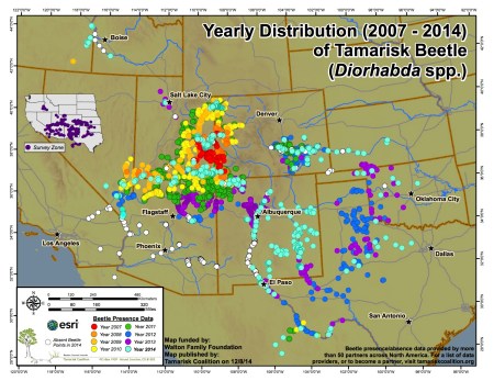
From the Tamarisk Coalition website:
Each year, with the help of numerous partners across eleven states and Mexico, TC produces an annual distribution map that notes the presence and absence of Diorhabda spp. from sampling sites across the west. These data in no way represent all locations where the tamarisk beetle may exist, but give a broad perspective of beetle dispersal, providing land managers with information that may help with their integrated pest management plans, restoration strategies, and funding opportunities. If you would like to participate in the program, or help fill any “gaps” you may see in current data on the map, please visit our tamarisk beetle monitoring program page.
For 2014, TC would like to thank more than 30 partners directly involved in providing this year’s data, and more than 60 that have provided data during the span of TC’s involvement in tracking beetle locations across the west. This year showed rapid population expansion in Kansas, Oklahoma, and eastern New Mexico, with a slowing of spread along the Rio Grande in New Mexico, and a “stall” in southern Arizona. This decreased expansion, as compared to movement the last few years, is most likely indicative of the Northern Tamarisk Beetle (Diorhabda carinulata) reaching the southern limits of its physiological constraints along the Colorado, Little Colorado, and Rio Grande. There are three other species of tamarisk beetle in North America, and this year was the first time that all four species were recorded in a single state, New Mexico.
The production of the Annual Tamarisk Beetle Distribution Map is generously funded by a grant from the Walton Family Foundation.
More tamarisk control coverage here.
@USGS: Fossil evidence for continental drift theory proposed over 100 yrs ago
Fossil evidence for continental drift theory proposed over 100 yrs ago. http://t.co/qbrQuwwiAk #FossilFriday pic.twitter.com/FDPSPkzlsh
— USGS (@USGS) February 27, 2015
Call it a compact: Why examining the limits of Colorado River sharing is key to a successful state water plan
Snowpack news: “February’s moisture could make up for a dry, warm January” — Chris Woodka
From The Pueblo Chieftain (Chris Woodka):
Snow along the Front Range has been intense this week: closing schools, making driving treacherous at times and filing up in drifts as people dig out.
But statewide, the average accumulation of snow so far remains below average at 82 percent of median.
Snowpack remains heaviest over the central mountains, which bodes well for this spring’s water supply. But the southern mountains and the far western part of Colorado remain below average.
As of Thursday morning, the Pueblo area had received about 15 inches of snow containing close to an inch of moisture for the month of February, which is above average.
That’s a lot for recent years, but not yet close to the record 20.1 inches of snow recorded at Pueblo in 1894. Pueblo received more than 17 inches in 1911 and 1939 as well.
Up to a foot of snow was left in the Upper Arkansas River basin by the storm that started Saturday night, while the storm that started Wednesday deposited about half that much.
More than 2 feet of snow has blanketed some mountain areas of the state, leaving snow stations at elevations above 11,000 feet anywhere from 123-144 percent of median.
The Arkansas River basin as a whole was listed at about 95 percent of median as of midnight Thursday, but snow continued to fall in the morning hours over much of the area.
The Upper Colorado River basin, which Pueblo and the Arkansas Valley rely on for supplemental water, was at 91 percent of normal early Thursday, with some headwater areas well above normal.
While the South Platte basin is in good shape at 106 percent, most of the state’s other basins still are struggling to reach average snowpack levels. The Rio Grande and Gunnison River basins are only at three-quarters average and the southwest corner of the state is lagging behind other areas.
March and April are typically the snowiest months, but February’s moisture could make up for a dry, warm January, which negated the benefits of early snows.
From The Dolores Star (Jim Mimiaga):
Southwest Colorado is expected to see steady precipitation through Wednesday, according to the National Weather Service.
Forecast models show the area receiving between 13 and 25 inches of new snow between Friday and the middle of next week, reports NWS meteorologist Joe Ramey.
“It looks persistent for quite a while with back-to-back storms,” he said.
The NWS has issued a winter storm watch for southwest Colorado beginning Friday at 6 a.m. and lasting until Monday at 8 p.m.
On Friday, the first storm hits in Cortez, bringing showers turning to snow overnight. Lower elevations like Cortez and Durango are right on the snow-rain line over the weekend, Ramey said. Weekend daytime highs are expected to be at or above freezing.
A second colder storm rolls in on Monday and is expected to generate steady snow for Cortez and the San Juan mountains.
“The colder air should make it all snow all the time,” Ramey said.
Last weekend’s storm dropped 24 inches of snow in the Dolores region, and 12 inches in Cortez, according to local weather watchers. Telluride reported 29 inches from the last storm.
Local meteorologist Jim Andrus said the upcoming storm system is similar to one in 1967 that dropped 18 inches of snow in Cortez and seven feet of snow in Flagstaff, Az.
“A deep, low-pressure trough over the Southwest is setting up a strong storm flow over the Four Corners,” Andrus said. “It is not a good travel weekend. The National Weather Service predicts Wolf Creek could receive up to 70 inches of new snow.”
After so many dry weeks, what changed?
Ramey explained that a high-pressure ridge in the atmosphere above California had been persistently blocking storms from reaching southwest Colorado. Last week, the ridge moved westward over the Pacific, allowing storms to go around and dive into Colorado.
The added moisture is good news for the Dolores Basin snowpack, which feeds McPhee Reservoir during Spring runoff. Before last weekend’s storm, the basin was one of the driest in the state.
Vernon Lamb, a technician for the Dolores Water Conservancy District that manages McPhee, reported that on Feb. 19, the Dolores Basin’s snow-water equivalent was at 61 percent of the median for that day.
By Monday, Feb. 23, the snow-water equivalent had jumped to 67.2 percent…
Despite the bump in snowfall, southwest Colorado’s overall snowpack is still the lowest in the state. The combined snowpack for the San Miguel, Dolores, Animas, and San Juan watersheds is at 68 percent of normal, as of Feb. 25. The state average is 82 percent of normal for that day.
From The Denver Post (Daniel Boniface):
Snow overnight Thursday in Denver led to a new snowfall record for the month of February with 22.2 inches recorded at Denver International Airport in 2015, breaking a 103-year-old mark.
The National Weather Service in Boulder announced overnight the new mark surpassed the previous record of 22.1 inches set back in February of 1912.
The weather service recorded 3.3 inches at DIA on Thursday to break the record.
From The Colorado Springs Gazette (Brian Bledsoe):
The past week has been AMAZING in terms of snowfall in Colorado!
Not only did communities along the Front Range receive some excellent snow totals, the mountains have been getting hit hard as well.
Since Friday, as much as 4 feet of snow has fallen in the mountains. The most encouraging news is the San Juan Range has been a big winner. Up until the past five days, the southwest part of the state hadn’t received much snow this winter, but the current weather pattern will continue to drop hefty amounts on ski areas such as Wolf Creek, Purgatory, Crested Butte and Monarch Mountain.
So while many folks have been skiing at the northern and central mountain resorts, now is a great time to break away and head south. Some of the best powder of the season exists at the aforementioned resorts.
The high country will continue to benefit from this wintry pattern, but less snow will fall at lower elevations. However, simply because it is less snow doesn’t mean it isn’t important. Colorado Springs is having one of its snowier winters in years, and that pattern looks to continue.
Remember, don’t curse the snow. The more that falls on the Pikes Peak region, the better the chances of avoiding water problems and fire danger problems in the near future.
Businesses stress flexibility in changing climate — the Fort Collins Coloradon
From the Fort Collins Coloradoan (Sarah Jayne Kyle):
Michael Baute, co-owner of Spring Kite Farm, knows his business needs to be flexible to stay viable in a shifting climate.
“I’ve staked my life on providing fresh, local food,” said Baute, who started his farm in southwest Fort Collins in 2012.
“It was super hot, super dry and I said, ‘Let’s start a farm,’” he laughed while speaking Thursday during a panel on climate change held at Colorado State University.
The farm lost its ditch water and was without irrigation until ash-laden runoff from the High Park Fire rendered water unusable for some industries, freeing it for farm use.
Baute said if he had not gotten water that year, the farm likely would not have survived. The following years launched a series of ups and downs, from floods in 2013 to a short growing season in 2014.
The farm endured snow on Mother’s Day, which Baute said is historically “when you transplant tomatoes,” and six hailstorms.
It soon became apparent that he would have to learn to adapt, Baute told those gathered Thursday at “Fort Collins on the Front Lines of Climate Change,” sponsored by Environment Colorado, CSU’s Student Sustainability Center and other regional partners.
Though the farm started growing only vegetables, Baute recently added a breeding program for pork and dairy goats to diversify the business.
“We have to build systems that are more resilient,” he said. “If I get hailed out this year, I still have pork on the market… I can build a system that keeps me out of bankruptcy.”
Ben Costello, “director of fun” at Fort Collins-based Mountain Whitewater Descents, said his industry has also started planning unpredictability on the Poudre River — the lifeblood of the rafting business. Up to 40,000 tourists go rafting on the Poudre every summer, Costello said.
Mountain Whitewater Descents, and other area rafting guides, were put out of commission for three weeks in 2012 during the High Park Fire.
“Frankly, we’re lucky to still be in business,” Costello said. “That’s a real eye-opener.”[…]
Environment Colorado representative Anna McDevitt said Costello’s and Baute’s stories are some examples of the local impacts of a changing climate.
“We are all victims of climate change,” she said. “There are multiple impacts that we’re feeling here in Northern Colorado.”
Oil And Gas Wastewater Presents A Business Opportunity For One Colorado Company — KUNC

From KUNC (Leigh Paterson & Inside Energy):
In 2013, Colorado and Wyoming produced around 128 million barrels of oil and a little more than 2.4 billion barrels of wastewater combined. North Dakota produced 300 million barrels of oil and nearly 360 million barrels of wastewater in 2013.
Wastewater disposal is a massive but little-known part of the oil and gas business. According to Boston-based water consulting firm Bluefield Research, the U.S. hydraulic fracturing industry spent over $6 billion in 2014 on water management. For those reasons, Colorado-based T-Rex Oil believes now is the perfect time to get into the business of wastewater disposal.
T-Rex Oil is looking to operate a wastewater disposal well in Western Nebraska, but may face an uphill battle to get the required permit. NET News Nebraska has reported that the company is facing strong opposition from residents. T-Rex’s application [.pdf] says the proposed project would be the largest operation of its type in the state, accepting upward of 80 truckloads a day of wastewater from Colorado, Wyoming and possibly Nebraska. The brine – a super salty, sometimes chemical-laden fluid – would then be processed on site before being pumped underground.
According to the Environmental Protection Agency, there are around 144,000 class II wells spread across the country. Most are actually aging oil wells that companies inject with carbon dioxide or other substances to get them to produce more oil, a process known as enhanced oil recovery. Other wells are used to store fossil fuels and about 20 percent are used to dispose of wastewater.
The wells used for brine disposal is what worries residents of Nebraska’s panhandle, who have concerns about spills, groundwater contamination, and an increased risk of earthquakes.
“I just have reasonable doubts about the safety,” Jane Grove told NET Nebraska. Her ranch sits near the T-Rex’s well site.
Spills have been a concern in North Dakota, where on average, more than 2 gallons of wastewater spills per minute. Most spills occur during transportation – the wastewater has to get to the well either by truck or pipeline – or storage tanks can leak.
Earthquakes are another concern of the residents. Injection wells and oil and gas exploration have been linked to human-caused quakes, also known as “induced seismicity.” In 2014, Oklahoma was found to have had more magnitude 3 or greater quakes than California. Greeley, Colorado had a brush with a human-caused temblor in 2014 as well, where activities at an injection were linked to a magnitude 3.2 shake. Geological activity in the area later tapered off when the well was shut for evaluation and later allowed to start operating again, albeit at lower pressures and volumes.
To many they are invisible, but injection wells, for now, are vital to the industry because they are the cheapest and most available way to dispose of oil and gas wastewater. As Justin Haigler, president of Black Bison — Wyoming’s largest water services company — notes, “without this water management, oil and gas doesn’t happen.”
More oil and gas coverage here.
2015 Colorado legislation: HB15-1038 (Flexible Water Markets), “It still looks like there’s still a speculation issue” — Jay Winner

From The Pueblo Chieftain (Chris Woodka):
Legislation purporting to offer more options for farmers appears to be just another way to dry up more farms in the eyes of a district set up to protect Arkansas Valley water.
The bill, House Bill 1038, would create a flexible water market right that would allow farmers to lease half their water to cities, recreation activities or even other farms. While it says it would keep water in farming, the district thinks it might do just the opposite.
“The way it was introduced, we just weren’t that interested,” said Jay Winner, general manager of the Lower Arkansas Valley Water Conservancy District. “But to me, it looks like another form of buy-and-dry. We don’t understand the need for it.”
Winner said the legislation, backed by water interests in the South Platte, would harm the Arkansas River basin by allowing 10 consecutive years of the entire consumptive use from a farm to be moved to other uses. The Arkansas Valley Super Ditch plans a pilot program this year that limits leases to just three years in 10.
“It still looks like there’s still a speculation issue,” Winner added. “We’re right back where we were last year on this same issue.”
The legislation passed the state House by a 42-22 vote on Feb. 10 and is now in the Senate.
The measure was substantially modified in the House agriculture committee and now includes a 10-year pilot program which would allow the Colorado Water Conservation Board and state engineer to evaluate the need and effectiveness of flex marketing.
The bill limits the number of flex use water rights in any given basin to 10 water court applications and 10 substitute water supply plans for the pilot program’s first 10 years.
It also allows for drying up farmland five years in every 10 in order to move the consumptive use portion of the water for uses other than irrigation of the property served by the water right.
Winner thinks there is a potential to “stack” the court and administrative routes, since nothing in the law prevents it.
The bill still prohibits transfers from one basin to another and includes a provision for fixed points of delivery — an attempt to comply with the state’s anti-speculation doctrine. However, Winner is concerned one point, such as Lake Pueblo, could still open use of the water to multiple users.
The fiscal note by Legislative Council attached to the bill indicates there could be increased water court caseload over time because water rights holders would be able to more easily sell water rights to other users and the number of change-inuse applications would increase.
More 2015 Colorado legislation coverage here
Forum on Agriculture: “Conservation, reuse, storage, and you have to do all of it now” — Greg Fisher

From The Greeley Tribune (Kayla Young):
Gov. John Hickenlooper addressed Colorado’s agricultural community Thursday in full Western style, donning a black Stetson cowboy hat for the annual Governor’s Forum on Colorado Agriculture at the Renaissance Hotel.
While the variation from the governor’s typical attire lightened the mood, the day touched on some of the most serious issues affecting the future of agriculture.
Water reigned as the topic of the day, carrying through not only Hickenlooper’s presentation, but also the day’s panel discussion led by 7News meteorologist Mike Nelson and the keynote speech by the governor’s water adviser, John Stulp.
Hickenlooper lauded the Colorado State Water Plan as vital to creating long-term security and better preparing the state for the challenges of climate change.
Stulp described the plan as achieving five major goals: fostering collaborative solutions to address the state’s looming supply gap, creating alternatives to the buy and dry of agricultural lands, protecting Colorado’s compact entitlements, pushing federal regulators to move more quickly on approval processes, and aligning state policies with dollars.
Stulp applauded the basin roundtable discussions that contributed to much of the legwork behind the water plan for bringing together diverse state interests that “would have otherwise only gotten together in a courtroom to sue each other.”
With Hickenlooper looking to expand international exports in agriculture, water security will play a key role in establishing confidence and capacity to move forward.
“Ag is one of the leading, if not the leading, industries in the state,” Hickenlooper said.
To bolster the sector further, he encouraged the passage of the Trans-Pacific Partnership to expand export markets for beef and pork. The proposed treaty would expand trade routes for U.S.-made goods in Asia, the Pacific and Latin America.
Hickenlooper also praised the Colorado Agricultural Leadership Program for bringing new advocates into the sector, and the Western Dairy Association for its efforts to afford veterans opportunities in agriculture.
Earlier in the day, a lively panel discussion led by Nelson touched on national, statewide and local water challenges, addressed by panelists Robert Sakata, Carlyle Currier, Reagan Waskom, Greg Fisher and Bart Miller.
The panel captured the complexity of Colorado’s state water laws, which often translate to decades of work to conclude infrastructure projects. With concern over excess flows entering Nebraska and potential calls on the Colorado River by western neighbors, one audience member asked why the state is not able to create more storage areas.
Waskom, director of the Colorado Water Institute, said uncertainty often leads well-intended projects off course.
“We see participants pull out because they’ve been putting money in and they don’t know if they’re going to get the storage in the end,” he said.
Greg Fisher, manager of demand planning for Denver Water, said, while additional storage would help, the state needs to look at supply development holistically.
“Storage will help, but we must take an all-of-the-above approach: conservation, reuse, storage, and you have to do all of it now,” Fisher said.
The panel differed on its opinions regarding the overall water use from fracking operations.
Waskom said the estimated 20,000 acre-feet of water that goes into hydraulic fracturing on the South Platte represents a drop in the bucket for the capacity of the river. Most of the water comes from systems such as Greeley’s that permit multiple use, which avoids additional demand.
One acre-foot of water is enough to serve four homes for a year.
Bart Miller, water program director for Western Resource Advocates, said while 20,000 acre-feet may not sound like a lot, when compared to the enormous cost of creating storage for such water, the quantity does equate to a meaningful amount in the grand scheme of things.
The panel also turned to the high groundwater levels damaging homes and farmland around Gilcrest and LaSalle in Weld County.
While Waskom said he has been living this drama for a decade, the water expert could not provide an easy solution.
“This is a really hard one to solve without someone getting harmed,” he said. “This is a classic Colorado water fight.”
While unity served as a recurring theme, discussion over Weld’s groundwater headache served as a reminder that on many water issues, cohesive solutions have yet to be found.
More education coverage here.
A tale of two tunnels: How the Moffat Tunnel conquered the divide
Environment: Study shows that even ‘isolated’ wetlands are crucial to protecting water quality
Workshop to focus on Big Thompson River restoration — @coloradoan
Workshop to focus on Big Thompson River restoration http://t.co/KDCo0Z0DKL pic.twitter.com/LwoUFmgDyt
— Coloradoan (@coloradoan) February 27, 2015
USGS: Where can I find bathymetric data? For the US, for the world?
[FAQ] Where can I find bathymetric data? For the US, for the world?http://t.co/u1hCkKLnnQ pic.twitter.com/hhExb5Val0
— USGS (@USGS) February 27, 2015
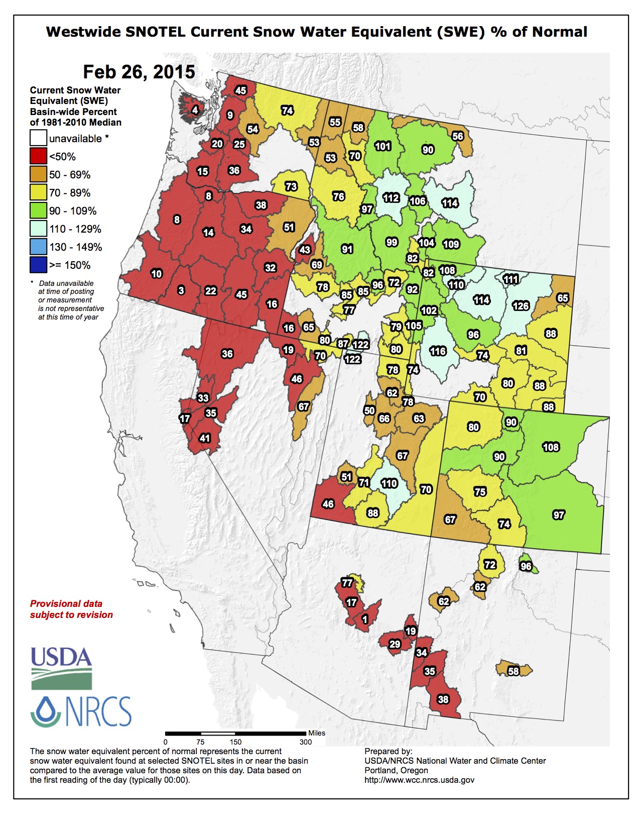
Snowpack news: South Platte Basin = 108% of normal (best in state), Upper Rio Grande climbs to 74%
Click on a thumbnail below to view a gallery of snowpack data for February 25, 2015 from the NRCS.

Statewide snowpack February 25, 2015 via the NRCS

Arkansas River Basin High/Low Graph February 25, 2015 via the NRCS

Upper Colorado River Basin High/Low Graph February 25, 2015 via the NRCS

Gunnison River Basin High/Low Graph February 25, 2015 via the NRCS

Laramie and North Platte Basin High/Low Graph February 25, 2015 via the NRCS

Upper Rio Grande River Basin High/Low Graph February 25, 2015 via the NRCS

San Miguel, Dolores, Animas, and San Juan Basin High/Low Graph February 25, 2015 via the NRCS

South Platte River Basin High/Low Graph February 25, 2015 via the NRCS

Yampa and White Basin High/Low Graph February 25, 2015 via the NRCS
The current snowpack for the Roaring Fork Watershed is down to 78% of normal. Even with the recent new snow, the snowpack continues to be…
— RoaringFkConservancy (@rfconservancy) February 26, 2015
Drought news: Above normal precip for parts of the Southwest and Rockies

US Drought Monitor February 24, 2015

West Drought Monitor February 24, 2015

Colorado Drought Monitor February 24, 2015
Click on a thumbnail graphic for a gallery of drought data from the US Drought Monitor.
Click here to go to the US Drought Monitor website. Here’s an excerpt:
Summary
The upper-level circulation pattern during this U.S. Drought Monitor (USDM) week was dominated by a strong trough over the eastern CONUS (contiguous United States) which funneled cold air masses into the central and eastern United States. Storm systems moving along the southern edge of the trough generated a wintry mix of weather, dumping locally heavy rain and snow from the Lower to Mid-Mississippi Valley on the western end to the Mid-Atlantic coast in the east, improving drought conditions … especially in the Mississippi and Ohio Valleys. The precipitation mostly missed the immediate Gulf of Mexico coastal areas, where drought expanded. An upper-level low pressure system moved across the ridge over the western CONUS and settled in over the Southwest near the end of the week, with above-normal precipitation falling across parts of the Southwest and Rocky Mountains. The week was drier than normal in the Pacific Northwest and much of the Intermountain Basin, where drought expanded. Temperatures in the West averaged above normal this week, but the anomalies were not as warm as in previous weeks…
The Northern Plains and Midwest
Most of the Central to Northern Plains and Upper Midwest were drier than normal this week, with some areas receiving no precipitation. Precipitation deficits in the Northern Plains to Upper Mississippi Valley continued to mount, exceeding 4 inches over the past 6 months in parts of the Dakotas and Minnesota. But winter is the dry season, and deficits during this time of year are less significant than during the warm season. The drier-than-normal autumn depleted soil moisture and set the state for potential spring concerns, and the current depiction of D0-D1 adequately represents this situation. With temperatures this week continuing well below normal and the ground remaining frozen, no change to the depiction was made in this area.
To the south, a major winter storm moved across the Tennessee and Ohio Valleys, dumping an inch or more of precipitation, mostly in the form of snow, across a wide area, with locally 3 inches or more in parts of southern Kentucky. The precipitation raised stream levels, replenished soil moisture, and erased precipitation deficits for the last 30 days. As a result, D0-D1 were pulled back in Kentucky and the Missouri bootheel. But significant deficits remained at the 60-90 day time scale, so areas of D0 and D1 remained to represent these longer-term conditions. Low stream levels along and north of the Ohio River remained a concern, but no expansion of D0 was made here due to the area receiving above-normal precipitation this week…
The Southern Plains to Southeast
A major winter storm system moved across the Lower to Mid-Mississippi Valley and Southeast during the middle of this USDM week, followed by another system at the end of the week which moved out of the Southern Plains and across the Southeast. These systems left a total of 1-3 inches of precipitation across an area stretching from northeast Texas to the Carolinas, with locally 3-5 inches in parts of Tennessee and northern Mississippi, replenishing soil moisture and filling streams. D0-D2 contracted in Tennessee, northern Mississippi, and adjacent Arkansas. A remnant of D1 remained in western Tennessee, and D1-D2 remained in northeast Arkansas, to reflect the continued significant precipitation deficits which remained over the last 3 to 5 months. The precipitation was enough to prevent further deterioration in northern Alabama to the Carolinas, but not enough to warrant improvement in the drought depiction. The storm systems mostly missed the Gulf of Mexico coastal areas, which generally received less than half an inch of moisture. D1 expanded from southern Louisiana to southern Alabama and the Florida panhandle where weekly precipitation was below normal and deficits continued to mount. Much of this area has very low streamflow levels and precipitation deficits exceeding 6 inches, and locally 9 inches, since the beginning of October.
In Texas, above-normal precipitation at the 7-day to 6-month time scales prompted the pullback of D2-D3 in the northwest corner of the panhandle, while D2-D3 expanded in south-central Texas near the Edwards Plateau. Deeper soil moisture, stock ponds, rivers, and reservoirs in western Oklahoma have never fully recovered from the drought which began 4 years ago. The Washita River has been completely dry for nearly the last 4 years, which local residents say is highly unusual, with the river generally not being without water for more than 90 days in the past. NASA satellite-based measurements of groundwater indicated severely dry conditions in western Oklahoma. D3 was expanded in western Oklahoma across Roger Mills, Custer, Beckham, and Washita Counties to better reflect long-term moisture deficits (over the last 15 to 72 months) as well as record low streamflow levels. D1-D3 were expanded in north central Oklahoma, and D1 in adjacent south central Kansas, where 7-day to 6-month precipitation deficits were greatest and surface water supplies continued to be a concern…
The West
It was another dry week for much of the West, with parts of the Pacific Northwest, Northern California, Arizona, New Mexico, and the Intermountain Basin receiving no precipitation. Scattered areas of the Pacific Northwest and Northern Rockies received half an inch to an inch of precipitation. A slow-moving upper-level weather system brought half an inch to 2 inches of precipitation to parts of Southern California and the Southwest, with 2-4 inches being reported over southwest Colorado. In California, D4 was pulled back in eastern Kern County and adjacent southeast Tulare County, but otherwise The Golden State remained locked in a years-long drought. At the University of California-Berkeley’s Central Sierra Snow Laboratory site near Donner Summit, there was only about a foot of snow on the ground, which is lower for late February than all of the dry winters in the last 70 years. Snow depth at this site never got above 3 feet this winter, when their usual maximum depth would be around 12 feet.
Mountain snowpack remained well below normal, not just in California but all across the Cascades, Sierra Nevada, and Intermountain Basin. The SNOTEL network snow water content ranked among the driest 5 percentile in the historical record for much of this area, with many SNOTEL sites unusually snow free this early in the season. The low mountain snowpack will significantly affect spring and summer water supplies, as melting of the mountain snowpack provides an important water source during the warm season. Mountain snow water content was above normal in only a few parts of the Northern and Central Rockies. D1 expanded along the southern Cascades of Washington, and was added to the Olympic Mountains, to reflect the low snowpack. D1-D3 expanded in southwest Idaho (Owyhee and Canyon Counties) to reflect basin impacts. D0 expanded in southeast Idaho and into southwest Montana and northwest Wyoming (in the vicinity of Yellowstone National Park) where streamflow levels, snow water content, and water-year-to-date precipitation were low. Mountain snow water content and water-year-to-date precipitation were well below normal in northwest Utah to southwest Wyoming. Even though up to an inch of precipitation was observed this week in southwest Utah, NASA satellite-based measurements of groundwater indicated very dry conditions from southwest Utah to southwest Wyoming. As a result, D1 expanded across southwest Utah, D0-D1 expanded in northeast Utah into southwest Wyoming, D2 expanded in northwest Utah, and a spot of D3 was added to northwest Utah…
Looking Ahead
The upper-level circulation pattern (of ridge west/trough east) will undergo a change in the next 7 days. Weather systems will undermine the western ridge, allowing colder-than-normal air to spread westward and encompass most of the CONUS. Some precipitation (a tenth of an inch or more) is expected to fall across most of the CONUS during February 26-March 3. An inch or more is forecast for parts of the Pacific Northwest, Southwest, and Southern to Central Rockies, and for most of the country from the eastern Plains to the East Coast. The eastern storm track is predicted to bring 2 or more inches of precipitation to the Mid-Mississippi Valley to Ohio Valley and Southern Appalachians, as well as the Coastal Carolinas. The driest areas are expected to be the Northern Plains, southwest Texas, and parts of California.
The 6-10 day and 8-14 day outlooks keep the area of below-normal temperatures across most of the CONUS, with only the extreme Southeast, as well as Alaska, warmer than normal. The greatest chances for above-normal precipitation during March 2-10 are expected to be over Alaska and the eastern third of the CONUS. Below-normal precipitation is expected over the West and Northern Plains, spreading across the Rockies and into the Midwest later in the period.
Happy 96th birthday @GrandCanyonNPS
Happy 96th birthday @GrandCanyonNPS! pic.twitter.com/H9rsp5uYz9
— National Park Service (@NatlParkService) February 26, 2015
Hoover Dam’s cobwebbed spillway — John Fleck

Hoover dam spilling

Hoover Dam during construction

Rarely seen back of the Hoover Dam prior to first fill

Hoover Dam during construction

Colorado River, Black Canyon back in the day, site of Hoover Dam

A full Lake Mead back in the day
From InkStain (John Fleck) (Click through for the photo):
Erika Moonin, the Southern Nevada Water Authority’s engineering project manager for construction of the agency’s new Lake Mead intakes, showed me a picture yesterday of water pouring over Hoover Dam’s spillways in 1983, the last time the reservoir spilled. When she was a youngster, her dad took her out to see the spectacle. Looking at it today, it’s hard to imagine. Current lake level is 137 feet below the 1983 peak…
* I didn’t actually see cobwebs. It’s literary license.
More Colorado River Basin coverage here.
Bureau of Reclamation: This map shows where invasive mussels have infested or been detected in our reservoirs or facilities
This map shows where invasive mussels have infested or been detected in our reservoirs or facilities #InvasiveSpecies pic.twitter.com/OfLRA9J8Px
— Bureau of Reclamation (@usbr) February 24, 2015
More invasive species coverage here.
City report examines Poudre River’s health — the Fort Collins Coloradoan

From the Fort Collins Coloradoan (Sarah Jane Kyle):
A report released by the city of Fort Collins could help define the Poudre River’s ecological future.
The Poudre River Ecological Response Model (ERM), which was created to understand possible future scenarios for the river, covers a 13-mile stretch of river through Fort Collins, from Overland Trail to Interstate 25.
A panel of river ecology experts will present the project to the public Thursday. Natural Areas Department Director John Stokes said the report identifies some challenges the urban river faces, as well as possible solutions.
“I think as a community we need to have a discussion about how much change is acceptable and what we can do to help this river feel like a river,” he said. “That’s going to be challenging because there are a lot of demands on the Poudre River.”
Stokes said the Poudre River in Fort Collins is “very much entrenched,” which has limited the river’s ability to function naturally.
“We’ve put the river in its place and it stays there,” he said. “If we can let the river move around or do some over-bank flooding where it’s safe, that gets back some of the ecological function we’ve lost over the last 100 years.”
The ERM offers 27 responses for four indicators of the river’s condition: physical setting, aquatic life, fish and riparian habitats. The report was a collaborative effort featuring nine team members from Colorado State University, U.S. Forest Service, The Nature Conservancy, U.S. Geological Survey and city of Fort Collins.
Research began in 2011 and was finalized late last year. Stokes said the ERM will serve “as a guide post and decision support tool” for future conservation and river health efforts.
“It doesn’t tell us exactly what to do,” he said. “But it helps us understand the river.”
Learn more
•Learn more about the Poudre River Ecological Response Model in a panel presentation from 4 to 5 p.m. Thursday at Colorado State University’s Lory Student Center.
•See the report at http://fcgov.com/naturalareas/eco-response.php.
More Cache la Poudre River coverage here.
Noontime Nature lecture, “The Story of Getting There” at the Loveland Public Library, March 3 and 4

John Wesley Powell at his desk—same desk used by the USGS Director today via the USGS

John Wesley Powell

John Wesley Powell’s recommendation for political boundaries in the west by watershed

John Wesley Powell
From the Loveland Reporter-Herald (Kevin J. Cook):
John Wesley Powell earned his fame twice: once for taking a direct hit from a cannon during the Civil War and once for passing through the Grand Canyon on a boat. The first made the second seem all the more remarkable.
But Powell was a remarkable person.
His mind was so eclectic that had his thoughts been light they would have been a rainbow. His ideas were like so many brilliant and distinctive hues; his ambitions were like so many gradations.
This trio of diversity, ideas and ambitions was simultaneously his strength and his weakness, a conflict that would stymie a lesser man.
Powell was the quintessential 80-percenter. He had the passion to pursue his ideas, but he only had the drive to get them going. Once one of his ideas was underway with a substantial measure of progress — 80 percent done — his heart and mind turned to the next idea leaving the previous project for others to direct and to complete.
And the one project for which he is best remembered is one that others finished, for Powell did not boat the Grand Canyon alone. Yet few can name those who ran the river with him. The leader gathers the glory.
Another tidbit also gets little attention: To get from Illinois to the Grand Canyon, he passed through Colorado. In other words, to get there he traveled here.
On July 8, 1868, Powell and his troupe known as the Rocky Mountain Scientific Exploring Expedition crossed into Colorado from Cheyenne, Wyo. They spent the summer engaging Colorado’s mountains and passes, parks and rivers.
Rather than passing through like so many sightseeing travelers, they came to engage this young territory. Powell intended to document what others knew but did not preserve in the language of maps.
Anyone could hire the guide services of a man like Kit Carson, but Carson was an illiterate who was good on the ground but incapable of preserving or passing on what he knew.
Powell put Colorado on the map; Powell put the map on Colorado.
Some people might argue that Powell’s time in Colorado was inconsequential because his work here was eclipsed by the trip through the Grand Canyon. A better argument would be that he made it through the Grand Canyon because he made it through Colorado.
Powell’s experiences in Colorado prepared him for the challenges that filled his life as a dreamer and a realist, as a conservationist before the word was coined, as an anthropologist and as a reluctant but motivated politician.
In Colorado John Wesley Powell found his muse.
If you go
The Noontime Nature lecture, “The Story of Getting There” at the Loveland Public Library, 300 N. Adams Ave., will be presented twice on Tuesday, March 3: noon to 1 p.m. and again 2 to 3 p.m. and will be repeated 6 to 7 p.m. on Wednesday, March 4. Third in a free year-long series about nature writing specific to Colorado sponsored by Friends of the Loveland Library, “Getting There” will feature John Wesley Powell’s passage through Colorado in the summer of 1868, as presented in Wallace Stegner’s book, “Beyond the Hundredth Meridian.”
Republican River Basin: Supreme Court finds Nebraska liable for ‘reckless’ water use — The Kansas City Kansan

From the Kansas City Kansan:
In a 28-page majority opinion, the court unanimous agreed that Nebraska “knowingly” violated the Republican River Compact and took water that belonged to Kansas.
As a remedy, the Supreme Court ordered by a 6-3 vote that Nebraska not only must pay Kansas’ actual damages from loss of water during those two dry years but also must “disgorge” a portion of the economic gain Nebraska received from higher yields from irrigating crops with water that should have been sent downstream to Kansas.
“Nebraska recklessly gambled with Kansas’s rights, consciously disregarding a substantial probability that its actions would deprive Kansas of the water to which it was entitled,” Justice Elena Kagan wrote for the court’s majority. “That is nearly a recipe for breach [of the Compact that governs sharing of Republican River water]—for an upstream State to refuse to deliver to its downstream neighbor the water to which the latter is entitled. And through 2006, Nebraska took full advantage of its favorable position, eschewing steps that would effectively control groundwater pumping and thus exceeding its allotment. In such circumstances, a disgorgement award appropriately reminds Nebraska of its legal obligations, deters future violations, and promotes the Compact’s successful administration.
”Schmidt noted that the Supreme Court never before had ordered disgorgement of an upstream state’s unjust gains as a remedy in an interstate water dispute.
“Legally, this is a groundbreaking case that vindicates Kansas’s rights as a downstream state,” Schmidt said. “We brought this lawsuit to encourage our neighbors to live up to their obligations in future dry periods. I’m hopeful this strong and clear Supreme Court order will have that effect.”
The Supreme Court ordered Nebraska to repay Kansas $3.7 million to compensate for Kansas’s actual economic losses during 2005-06 and another $1.8 million as partial disgorgement of Nebraska’s unjust gains from illegally using Kansas water.
That $5.5 million recovery will be used to fully reimburse the attorney general’s office for its roughly $4.5 million in bringing the lawsuit and defending Kansas water rights, making the State of Kansas whole for its cost of litigation. The remainder will be available to the legislature to designate for other purposes as provided by law.
The Supreme Court also ordered technical changes to the calculation of future water flows from the Platte River basin into the Republican River basin as requested by Nebraska. The decision to order that reformation of the accounting procedure was 5-4.
More Republican River Basin coverage here.
NIDIS: Weekly Climate, Water and Drought Assessment of the Upper #ColoradoRiver Basin

Click here to read the current assessment. Click here to go to the NIDIS website hosted by the Colorado Climate Center.
Denver Water: @hickforco Forum on Colorado Ag to focus on water needs across state
RT @ColoradoStateU: @hickforco Forum on Colorado Ag to focus on water needs across state: http://t.co/rqdYaO739F pic.twitter.com/R8Iq5389yB
— Denver Water 💦 (@DenverWater) February 24, 2015
Do you know your snowpack?
The Aspinall Unit operations meeting minutes are hot off the presses #ColoradoRiver

Click here to read the minutes from the recent Aspinall Unit Operations meeting.
Snowpack news: San Luis Valley hit hard by storm — the Valley Courier

From the Valley Courier (Ruth Heide):
After unseasonably warm temperatures and extended periods with no precipitation, this past weekend began to make up for some of the winter the Valley had missed so far.
Weekend snowfall reports ranged from 8 inches in Alamosa to nearly a foot farther south in Conejos County and 39 inches of new snow at the Wolf Creek Ski Area.
As snow began to pile up throughout the day on Sunday , area schools started announcing closures for Monday. By late Sunday all of the public schools in the San Luis Valley had declared a snow day for Monday. Adams State University and Trinidad State Junior College also called off classes on Monday, and some businesses and governmental agencies were closed…
However, skies are expected to be overcast all week, and the chance of precipitation will increase from 10-20 percent midweek to 30 percent by Thursday night. Friday and Saturday will bring about 30 percent chance of precipitation , according to the National Weather Service. Temperatures will also remain colder this week, with high temperatures in the mid 30’s . The Valley will not likely surpass 40 degrees again until Saturday.
The San Luis Valley and surrounding mountains were under a hazardous weather watch through most of Monday, and avalanche warnings are in effect in the mountains and backcountry at least through noon today, Feb. 24. The
Colorado Avalanche Information Center issued a warning for the Sangre de Cristo,
Southern San Juan and Northern San Juan Mountains through midday Tuesday , due to the significant amounts of new snow and winds creating dangerous conditions in the backcountry of Colorado’s southern mountains. Wolf Creek Pass was closed on the west side for avalanche control for a time on Monday but had reopened by midday. Avalanche control was planned on Monarch Monday night.
All mountain and high Valley areas will have hazardous travel conditions because of the icy and snowpacked roads, and motorists are urged to use caution.
“Drivers are cautioned to drive slow and be patient,” City of Alamosa officials urged.
“Our crews are set to do their jobs,” Colorado Department of Transportation Executive Director Shailen Bhatt said. “We are asking for the same level of preparedness from drivers. We cannot stress enough the need for folks to know the conditions, prepare their vehicles with good snow tires and topped up fluids, and drive for the conditions.”
He added, “Travelers should check http://www.cotrip. org before heading out.”
Colorado State Patrol was busy responding to accidents throughout the recent snowstorm but accident statistics were not available by press time Monday. Most involved vehicles sliding off the road. CSP urged motorists to take it slow and stay off the slick roads unless absolutely necessary.
On the bright side, in addition to more powder at the ski area and a snow day for school children, this weekend’s snowstorm brought a boost to the area’s lagging snowpack. By Monday the snowpack had risen to 67 percent of normal basin wide, which still offers plenty of room for improvement.
Some areas of the San Luis Valley were showing more positive numbers. For example, Cochetopa Pass was at 134 percent of normal snowpack and Medano Pass at 100 percent, which bodes well for streams at the Great Sand Dunes National Park & Preserve this summer.
From The Mountain Mail (Brian McCabe):
The blue light, announcing 6 or more inches of snow, lit up on top of Tenderfoot Mountain Monday night following a weekend storm that dropped 17 inches of new snow at Monarch Mountain and 5-8 inches around Salida.
The fluffy, dry snow resulted in 0.55 inch of precipitation in Salida.
Monarch now has a mid-mountain base of 70 inches, and the new powder bumped the resort’s numbers for Monday.
“We definitely had higher numbers today,” Jessie Smith, marketing coordinator said. “School having a snow day helped as well.”
Salida schools canceled classes for a rare snow day.
“I’ve been here for 5 years, and it’s the first one I know about,” said Salida School District Superintendant Darryl Webb.
“I talked to school board member Kyle Earhart, who has been around for 9 years, and this is the first one he remembers as well.”
Webb said the school district doesn’t have a hard and fast rule for deciding when to call a snow day for the schools.
“We contact the county first,” Webb said, “and Evalyn Parks (district transportation director) and I will drive the roads early, to see what they are like, before making a decision.”
Webb said in the case of this snow day, they decided the night before after hearing the forecast for snow to continue falling through noon.
Webb said the district has extra days built into its calendar for just such days, so the students won’t have to make up any days at the end of the year.
“Unless we get a lot more snow,” he said.
The National Weather Service has forecast a hazardous weather outlook through the coming weekend for south central and southeast Colorado.
A new weather system will begin Wednesday evening and last through the weekend, bringing a chance of snow Wednesday through Friday and significantly colder temperatures Thursday and Friday.
The latest newsletter from the Water Center at Colorado Mesa University is hot off the presses

Click here to read the newsletter. Here’s an excerpt:
SEMINAR ON AG FUTURE 2/25, 6-9PM
The final session of our 2015 Water Course, which is focused on the future of irrigated agriculture, will take place at CMU and will be live-streamed on the internet from 6-9pm. For full details, click here.
More education coverage here.
The South Platte is key to the #COWaterPlan — The Fort Morgan Times

From The Fort Morgan Times (Sara Waite):
The South Platte Basin and Metro Roundtables, which collectively represent the South Platte River Basin, collaborated on a Basin Implementation Plan (BIP). The draft BIPs from each basin were released last summer; the final drafts are due in April.
The two organizations have been seeking public input on the draft South Platte BIP, offering a series of meetings and webinars in various locations throughout the basin.
A video produced by the group to give an overview of the water plan and BIP explains, “A good Colorado plan is a good South Platte plan.” The South Platte basin is a key economic driver of the state, with seven of the state’s top 10 agriculture-producing counties, as well as the Denver metro area and growing communities like Loveland, Greeley and Fort Collins that together account for over half of the state’s economic activity. The basin’s economy is also enhanced by environmental and recreational tourism — skiing, boating, fishing, wildlife viewing and hunting — and is home to the most-visited state parks and the eastern half of the Rocky Mountain National Park.
The South Platte Basin is a leader in water conservation efforts. “Long-standing efforts to conserve and reuse water in order to get the most benefit from available supplies has meant that by the time water flows out of our state, each drop has been used multiple times for different purposes,” the video states.
But a growing population base in the basin and statewide means municipal and industrial water demand could double before 2050, and outpace the state’s current water supply. Following current trends could mean drying up over half of the basin’s irrigated cropland in that time, a practice that, if overused, is “not in the best interest of the Basin nor is it in the best interest of the State.”
The South Platte plan calls for pragmatic solutions that are consistent with Colorado law and property rights. These include a wide range of strategies that could be used in various combinations to meet the gap: conservation and reuse; multi-purpose water projects that include municipal, industrial, recreational and environmental components; agricultural transfers, including alternative transfer methods; Colorado River Basin supplies; and storage projects.
The competing needs present enormous challenges, the BIP notes, and those challenges drive the solutions. Joe Frank, chair of the South Platte Basin Roundtable, has called for public feedback on the solutions outlined in the draft plan to meet current and future water needs.
To learn more about the South Platte BIP and Colorado Water Plan, as well as give feedback on the plan, visit http://www.southplattebasin.com/.
On Monday the City of Aspen officially ended its pursuit of a hydroelectric generation plant on Castle Creek — Aspen Journalism
On Mon, #Aspen officially ended its pursuit of a hydro plant on Castle Crk. Reso: http://t.co/saHrZP7Jhe Memo: http://t.co/aPvBoIbThH
— Aspen Journalism (@AspenJournalism) February 24, 2015
Arkansas Basin Roundtable recap: Focus on agriculture

From The Pueblo Chieftain (Chris Woodka):
While its purpose is to find ways to fill the municipal water gap, the Arkansas Basin Roundtable wants to elevate the importance of agriculture. That was apparent in several actions at its monthly meeting this week.
The most obvious was the adoption of a statement proposed by Reeves Brown, a Beulah rancher and board member of the Lower Arkansas Valley Water Conservancy District, that stresses the irrigated agriculture to tourism, food production, recreation, environment, general well-being and the economy.
The roundtable also selected a rural advocate rather than a water utilities manager for a vacancy on its executive committee.
Finally, it demanded more details from El Paso County interests seeking a state grant to determine if it would ultimately encourage more dry-up of agriculture.
“I would like to give my thanks to the roundtable for supporting agriculture. This is an important issue,” Brown said.
Support came without objection after Gary Barber, a consultant who chaired the roundtable until becoming a consultant for it, detailed years of projects that aimed at reducing buy-and-dry of farmland for municipal supply.
Some of those projects included : A 2005 Colorado State University study that assigned per-acre economic value for farm crops.
A 2008 template for community considerations developed by roundtable members.
An economic report that pegged farm losses from the 2011 drought at $100 million in the Arkansas Valley. That was followed in 2012 by a roundtable project that estimated the value of agriculture in the valley at $1.5 billion.
A 2013 workshop hosted by the roundtable that brought national speakers to discuss how ag water is valued.
The roundtable selected Sandy White, who touted his upbringing on a Wyoming Ranch and his desire to preserve agriculture, for vice president over Brett Gracely, water resources manager for Colorado Springs Utilities. The vote was not close, 26-5.
More IBCC — basin roundtables coverage here.
Thank you President Obama #kxl

President Obama at Hoover Dam

Hayfield message to President Obama 2011 via Protect the Flows

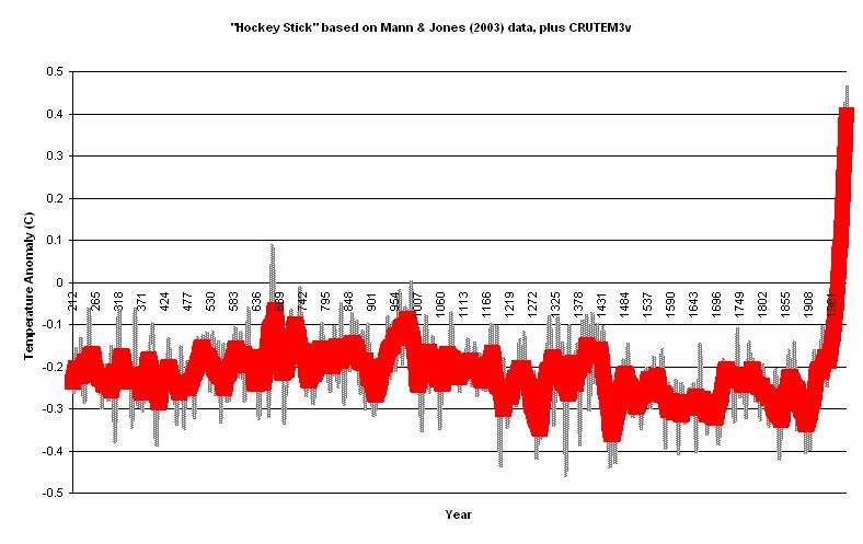
Hockey Stick based on Mann & Jones 2003

Science Senator. It’s called science.
From the Associated Press via The Greeley Tribune:
Defying the Republican-run Congress, President Barack Obama rejected a bill Tuesday to approve construction of the Keystone XL oil pipeline, wielding his veto power for only the third time in his presidency.
Obama offered no indication of whether he’ll eventually issue a permit for the pipeline, whose construction has become a flashpoint in the U.S. debate about environmental policy and climate change. Instead, Obama sought to reassert his authority to make the decision himself, rebuffing GOP lawmakers who will control both the House and Senate for the remainder of the president’s term.
“The presidential power to veto legislation is one I take seriously,” Obama said in a brief notice delivered to the Senate. “But I also take seriously my responsibility to the American people.”
Obama vetoed the bill in private with no fanfare, in contrast to the televised ceremony Republican leaders staged earlier this month when they signed the bill and sent it to the president. House Speaker John Boehner, R-Ohio, said Republicans were “not even close” to giving up the fight and derided the veto as a “national embarrassment.”
The move sends the politically charged issue back to Congress, where Republicans haven’t shown they can muster the two-thirds majority in both chambers needed to override Obama’s veto. North Dakota Sen. John Hoeven, the bill’s chief GOP sponsor, said Republicans are about four votes short in the Senate and need about 11 more in the House.
Although the veto is Obama’s first since Republicans took control on Capitol Hill, it was not likely to be the last. GOP lawmakers are lining up legislation rolling back Obama’s actions on health care, immigration and financial regulation that Obama has promised to similarly reject.
“He’s looking at this as showing he still can be king of the hill, because we don’t have the votes to override,” Republican Sen. Jim Inhofe of Oklahoma, a vocal opponent of Obama’s climate change agenda, said in an interview. “If he vetoed this, he’s going to veto many others that are out there.”
First proposed more than six years ago, the Keystone XL pipeline project has sat in limbo ever since, awaiting a permit required by the federal government because it would cross an international boundary. The pipeline would connect Canada’s tar sands with refineries on the Texas Gulf Coast that specialize in processing heavy crude oil.
Republicans and the energy industry say the $8 billion project would create jobs, spur growth and increase America’s independence from Mideast energy sources. Democrats and environmental groups have sought to make the pipeline a poster child for the type of dirty energy sources they say are exacerbating global warming.
For his part, Obama says his administration is still weighing the pipeline’s merits, and he has repeatedly threatened to veto any attempts by lawmakers to make the decision for him.
The GOP-controlled House passed the bill earlier in February on a 270-152 vote, following weeks of debate and tweaks in the Senate to insert language stating that climate change is real and not a hoax. Republican leaders in Congress delayed sending the bill to the White House until they returned from a weeklong recess, ensuring they would be on hand to denounce the president when he vetoed the bill.
The veto forced Republicans, still reveling in their dramatic gains in the midterm elections, to confront the limitations of being unable to turn their ideas into law without the president’s consent — despite the fact they now control both chambers of Congress.
Republican leaders were mulling a number of potential next steps. In addition to trying to peel off enough Democrats to override Obama’s veto — an unlikely proposition — Republicans were considering inserting Keystone into other critical legislation dealing with energy, spending or infrastructure in hopes that Obama would be less likely to veto those priorities, said Hoeven, R-N.D.
“We’ll look to see if we can get some more bipartisan support,” said Hoeven.
Obama last wielded his veto power in October 2010, nixing a relatively mundane bill dealing with recognition of documents notarized out of state. With the Keystone bill, Obama’s veto count stands at just three — far fewer than most of his predecessors. Yet his veto threats have been piling up rapidly since Republicans took full control of Congress, numbering more than a dozen so far this year.
The president has said he won’t approve Keystone if it’s found to significantly increase U.S. emissions of carbon dioxide, the chief greenhouse gas blamed for global warming. A State Department analysis found that the tar sands would be developed one way or another, meaning construction of the pipeline wouldn’t necessarily affect emissions. The Environmental Protection Agency earlier this month called for that analysis to be revisited, arguing that a drop in oil prices may have altered the equation. [ed. emphasis mine]
Snowpack news: Woo hoo! The San Juans got some precipitation in the wintertime for a change.

San Miguel, Dolores, Animas, and San Juan Basin High/Low Graph February 23, 2015 via the NRCS

Arkansas River Basin High/Low Graph February 23, 2015 via the NRCS

Upper Colorado River Basin High/Low Graph February 23, 2015 via the NRCS

Gunnison River Basin High/Low Graph February 23, 2015 via the NRCS

Laramie and North Platte Basin High/Low Graph February 23, 2015 via the NRCS

Upper Rio Grande River Basin High/Low Graph February 23, 2015 via the NRCS

South Platte River Basin High/Low Graph February 23, 2015 via the NRCS

Yampa and White Basin High/Low Graph February 23, 2015 via the NRCS

Statewide snowpack February 23, 2015 via the NRCS
Snow amts-Telluride Ski 25in;Silverton 20in;Pagosa 19in;Hermosa 18in; Montrose 12-18in;Durango 12-18in;Bluff 11in;Blanding 6in #cowx #utwx
— NWS Grand Junction (@NWSGJT) February 24, 2015
From the Associated Press (Steven K. Paulson) via the Glenwood Springs Post Independent:
The storm has been a good snow-maker for the northern and central mountains with 10 to 15 inches at some resorts and a grand total over the weekend of 18 to 24 inches.
Boulder broke a record for the month, with 34 inches of snow compared with 32 inches three years ago.
Last year, Denver International Airport got 38 inches of snow for the season. This year, the airport had about 30 inches of snow before the storm began, and officials expect another 14 inches by Monday morning…
National Weather Service meteorologist Jim Kalina said Sunday that it’s a bit late in the month for heavy, lingering snow and low temperatures, but by no means a record for Colorado. March is usually the snowiest month along the Front Range.
From The Durango Herald:
Durango Mountain Resort reported 21 inches of snow in 24 hours and Wolf Creek Ski Area said 30 inches fell there in 24 hours. Wolf Creek has received 199 inches to date…
Up to a foot of snow fell in parts of the Denver area. Boulder broke a record for the month, with 34 inches of snow compared with 32 inches three years ago.
Here's a nifty Snowfall Map from the Denver/Boulder Forecast office.http://t.co/ufOQtRPPAS. Make sure to zoom out! #cowx #snow
— NWS Grand Junction (@NWSGJT) February 24, 2015
https://twitter.com/martyconiglio/status/570202272371601409
From The Pueblo Chieftain (Matt Hildner and Tracy Harmon):
A mild, dry winter changed course Sunday and Monday in the San Luis Valley and the surrounding high country.
Parts of the San Juan Mountains received nearly three feet of snow, while more than a foot fell on the west side of the valley floor.
Weather spotters for the Community Collaborative Rain, Hail and Snow Network reported 16 inches near South Fork, 12 inches in Del Norte and 10 inches in Creede Monday morning.
The biggest totals from the multiday storm came from Wolf Creek Ski Area, which reported 34 inches of snow.
Snowfall totaled 8 inches in Alamosa, while 6 inches fell near Crestone, according to spotters for the National Weather Service.
The snow led Adams State University and all 14 of the valley’s school districts to cancel classes Monday.
All of the courts in the 12th Judicial District were closed by 2 p.m. because of weather and road conditions.
“The roads were bad pretty much across the entire valley,” said Capt. George Dingfelder of the Colorado State Patrol.
Despite the conditions, he said there were only a few crashes and only one of those included minor injuries.
Heavy snow and high winds in both the San Juan and Sangre de Cristo mountains prompted the Colorado Avalanche Information Center to issue an avalanche warning for back country recreation in both mountain ranges.
State transportation work crews conducted morning avalanche control work on the west side of Wolf Creek Pass, prompting a closure of U.S. 160 that was lifted by 1 p.m.
Public schools in Canon City, Florence and Penrose also were closed Monday after heavy snowfall Sunday.
In Canon City snow totals ranged from 7 to 10 inches, while Penrose residents reported 6 to 12 inches of snow. Snow measurements were made difficult by blowing and drifting.
Custer County was harder hit with 14 inches of snow in the lower elevations and a whopping 26 inches reported seven miles west of Westcliffe in the high country.
In Chaffee County, Salida residents reported 10 to 13 inches while Maysville residents reported up to 19 inches in the higher elevations and Buena Vista weather spotters reported 6 inches of snow.
Monarch Mountain reported 15 inches of new powder in the past 24 hours and a two-day storm total of 19 inches of snow. The ski resort now has a 70-inch base topped with plenty of new flakes for powder-loving skiers.
Forecasters are calling for a bit of melting Tuesday followed by a 60 percent chance of new snow on Wednesday.
Water Lines: Potential consequences of an early spring

From The Grand Junction Free Press (Hannah Holm):
Last week, I noticed crocuses blooming in my yard. I like crocuses, but it makes me a little uncomfortable to see them blooming in Grand Junction in early February. Will the unseasonable warmth trick other blossoms, like the all-important peach blossoms, into coming out early as well, only to be destroyed by the inevitable late freeze? What about this year’s water supply?
As plants all over the valley begin breaking dormancy, ditch companies are contemplating the possibility of an early start to the irrigation season. A longer growing season means more water use, of course, and the same warm spell that is prompting plant growth in the valleys has coincided with dry times in the mountains.
After ending December 2014 above average, the snowpack in the Upper Colorado River basin has added very little moisture so far in 2015. As of Feb. 12, the amount of water held in the snow in the Colorado River Basin in Colorado was just 89 percent of average for this time of year. Other Western Slope river basins are in worse shape, with the Yampa and White river basins at 83 percent of average, the Gunnison at 71 percent of average, and the southwestern basins at a mere 58 percent of average for this date.
Dry conditions in southwestern Colorado are especially concerning, because this area has failed to reach “average” snowpack levels for several years in a row. This has led to the first-ever shortage in deliveries from the San Juan River to central New Mexico through the San Juan: Chama project.
Mostly healthy reservoir levels in Colorado mean that local irrigators are unlikely to suffer in the short term, even if dry conditions continue. However, the Colorado basin-wide imbalance between supply and demand will likely be exacerbated by the warm, dry winter experienced across the West.
On the demand side, the intense drought in California continues, increasing that state’s reliance on Colorado River water. On the supply side, as of Feb. 9, the snowpack for all basins upstream from Lake Powell was at just 85 percent of the median for this time of year, and the reservoir was just 46 percent full.
In the short term, this confluence of factors could hasten the day when Arizona farmers with the most junior water claims come up short, as their deliveries of Colorado River water are cut. Upstream, efforts to keep water levels in Lake Powell high enough for the Glen Canyon Dam to keep producing hydropower are likely to intensify. Increasing releases from upstream reservoirs, such as Flaming Gorge and Blue Mesa, and incentivizing cutbacks in water use by both farms and cities are two of the avenues identified by Upper Colorado River Basin state officials to prop up Powell.
An increasing number of studies indicate that higher demands on reduced supplies are not just a temporary consequence of the current regional drought, but could become a chronic condition. The recently released Colorado Climate Change Vulnerability Study, developed by researchers at the University of Colorado and Colorado State University for the Colorado Energy Office, recaps data on the observed warming of Colorado’s climate in recent decades along with climate projections in order to assess what sectors of the state’s economy and environment could be stressed as the climate continues to change.
The study notes that towns and irrigators with little storage upstream are at risk for water shortages as the snowpack continues to melt off earlier, further dropping late summer stream flows. Low flows in late summer can stress fish as well, and shorten the season for rafters. The study also notes that fruit growers are vulnerable to crop losses from frost damage due to early budburst. You can find the complete study at http://wwa.colorado.edu/.
It’s still not too late for spring storms to bring back cooler temperatures and rescue the 2015 water year, but it’s also not too early to start planning for the possibility that at some point, what seems like a crazy-early spring could become our new normal.
This is part of a series of articles coordinated by the Water Center at Colorado Mesa University in cooperation with the Colorado and Gunnison Basin Roundtables to raise awareness about water needs, uses and policies in our region. To learn more about the basin roundtables and statewide water planning, and to let the roundtables know what you think, go to http://www.coloradomesa.edu/WaterCenter. You can also find the Water Center on Facebook at Facebook.com/WaterCenter.CMU or Twitter at Twitter.com/WaterCenterCMU.
More education coverage here.
Water woes among top voter concerns in the west — Conservation in the West poll
From The Greeley Tribune (Kayla Young):
Concern over water conservation and management for the first time rivals unemployment in the minds of voters in the West, according to recent data released by the Colorado College State of the Rockies Project.
The study polled 400 voters each from Arizona, Colorado, Montana, New Mexico, Utah and Wyoming, all which indicated water as a major concern for the state.
Overall, four in five voters indicated “inadequate water supplies” were a serious problem, while half ranked the issue as very or extremely serious.
Since 2012, the percent of voters that find inadequate water supplies to be a serious issue has grown 5 percent to 80 percent total.
When compared side-by-side with unemployment, water worries stand out as a hot issue for voters.
In the 2015 study, 53 percent polled found low levels of water in rivers to be extremely or very serious, compared to 46 percent regarding unemployment.
In 2014, these numbers were reported at 50 percent and 54 percent, respectively.
Lori Weigel, a pollster and partner with Public Opinion Strategies, said that while concern is most acute in southern states such as Arizona and New Mexico, interest has increased across the region on this vital resource.
“We’ve really seen a growing recognition in our state (Colorado) that supplies are limited, even if we are not at any one time technically in a drought,” Weigel said.
Water quality also ranked as a leading reason for residing in the West, Weigel said.
“We asked people to tell us some of the factors on why they decided to live and stay in (the) West. It was kind of surprising to me: clean air, clean water and environment,” she said, indicating that pollsters had anticipated greater importance given to economic factors.
In Colorado, 90 percent pointed to the clean environment as a reason for living in the state.
The finding coincides with another in the study, indicating Western voters prefer water conservation over further diversions to address demand.
In Colorado, 74 percent chose “using our current water supply more wisely, by encouraging more water conservation, reducing use, and increasing recycling of water,” compared to 16 percent of voters that preferred “diverting more water from rivers in less populated areas of the state to communities where more people live.”
Importance of inadequate water supplies
Arizona
Serious – 87%
Extremely/very serious – 58%
Colorado
Serious – 78%
Extremely/very serious – 48%
Montana
Serious – 44%
Extremely/very serious – 17%
New Mexico
Serious – 85%
Extremely/very serious – 62%
Utah
Serious – 85%
Extremely/very serious – 62%
Wyoming
Serious – 46%
Extremely/very serious – 20%
For more on the studies findings on water, click here.
Bathtub Ring, and yet more thoughts on why Lake Mead is dropping — John Fleck #ColoradoRiver
From InkStain (John Fleck):
One of the innovations in the 2007 shortage sharing agreement among the federal government and the seven basin states was the creation of “Intentionally Created Surplus” water management widget, a tool to free Lower Colorado River Basin water users from the tyranny of “use it or lose it”. Its purpose, according to the decision document that created it (pdf), was to “minimize the likelihood and severity of potential future shortages” by allowing water users to bank unused water in Lake Mead:
ICS may be created through projects that create water system efficiency or extraordinary conservation or tributary conservation or the importation of nonColorado River System water into the Mainstream. ICS is consistent with the concept that entities may take actions to augment storage of water in the lower Colorado River Basin.
The 2007 agreement anticipated use of things like fallowing, desalination and canal lining to create ICS credits.One of the big ICS users has been the Metropolitan Water District of Southern California, which by the end of 2012 had banked 489,389 acre feet of ICS credits in Lake Mead. But with drought hitting California and Met in a big way, in 2013 the agency began taking its banked water out, withdrawing 93,858 acre feet in 2013 and another 331,965 of ICS water in 2014.
This is a smart water management tool, allowing MWD to build some resilience by saving water now in order to consume it later. But it offers zero overall net basin water conservation over longer time frames – water conserved in one year is simply used in a later year. ICS simply moves water in time. That 331,965 acre feet Met took out last year above and beyond its normal allocation is five feet of elevation it put in in previous years and withdrew in 2014.
ICS is a cool tool, but the only thing that will keep Lake Mead from dropping is a new class of policy tool that would allow conserved water to stay in the reservoir for good.
More 2007 Shortage Sharing Agreement coverage here.
The state of oil and gas pipeline regulation in Colorado

From The Denver Post (Bruce Finley):
A spill from an underground pipeline northeast of Denver has contaminated soil and possibly groundwater — the latest of at least 13 spills over the past year from oil and gas pipelines that are largely unregulated.
While none of the recent spills appears unusually large, they highlight a gray area in how Colorado and other states are handling the domestic energy boom.
The Colorado Oil and Gas Conservation Commission receives spill reports but does not regulate or inspect pipelines beyond well pads, COGCC spokesman Todd Hartman said. Federal authorities say they regulate interstate pipelines that transport oil and gas, but this does not cover tens of thousands of miles of production-related pipelines within states.
The Colorado Public Utilities Commission regulates nonliquid gas lines around the state, PUC pipeline safety chief Joe Molloy said.
But no government agency regulates the proliferating production and other pipelines that carry natural gas liquids, Molloy said. These can be hazardous, containing ethane, propane and cancer-causing benzene.
A DCP Midstream operator saw stained surface soil about 7 miles north of Keenesburg on Jan. 30 and reported the spill. DCP has excavated 7 cubic yards of the soil and deployed a contractor to conduct lab tests for benzene and other toxic chemicals and to find the leak.
DCP officials “don’t have any more information just yet on source or contamination levels or groundwater impacts of the spill near the Tampa Compressor,” corporate spokeswoman Sarah Rasmussen said. “All of that is still being investigated and assessed.”
Moving oil and gas through pipelines promises safety and environment benefits — an alternative to trains and tanker trucks. For companies, pipelines can be cheaper, depending on fuel costs. In recent years, more trains are hauling crude oil from North Dakota and tar sands from Canada, leading to accidents such as last week’s disasters in Ontario and West Virginia.
Nationwide, more than 2.6 million miles of underground pipelines carry natural gas, crude oil and natural gas liquids from producing fields to refineries, according to the U.S. Department of Transportation’s Pipeline and Hazardous Materials Safety Administration.
But PHMSA officials estimate more than 200,000 miles of “gathering line” pipelines are unregulated in Colorado and other states.
The federal authorities are considering expanding their purview to regulate and inspect these pipelines, PHMSA spokesman Damon Hill said.
“We’re here to make sure operators are doing all they can to protect the environment and the safety of the public that may live near these pipelines,” Hill said.
“There’s a lot of development in the country where pipelines that were once in rural areas are no longer as rural. A lot of homes and businesses are now located near these pipelines. We want to make sure operators are indeed making sure the unregulated pipelines are safe.”
In recent Colorado legislative sessions, industry officials pushed to bolster companies’ power to condemn private property in order to install more pipelines.
Yet the impact of pipelines and spills from pipelines remains uncertain.
The COGCC spill database shows DCP reported 13 spills from its pipelines since February 2014. Most appear relatively minor, due to human error or equipment problems, though toxic material in some cases has contaminated groundwater.
Among the spills:
• In January, a DCP trencher hit a pipeline in Weld County, causing a spill, leading to an excavation of 40 cubic yards of contaminated soil.
• In November, a trencher hit an 8-inch pipeline and the spill contaminated groundwater — within a half mile of two water wells — spreading contamination at levels above the standards. DCP contractors excavated 370 cubic yards of soil and removed 40 barrels of contaminated groundwater.
• In September, five to 100 barrels of liquids leaked from a 10-inch underground pipeline inside the town of Frederick.
Colorado regulators have not taken enforcement action in response to any of these spills, according to COGCC records.
“A spill by itself doesn’t necessarily result in enforcement steps, but failure to report it, contain it and clean it up will,” Hartman said.
DCP officials pointed out that the COGCC lowered its threshold for reporting spills in 2014.
“In general, increases in reported releases in 2014 are likely attributable to this substantially lower reporting threshold,” Rasmussen said. For example, she said, DCP reported five spills in 2013 compared with 11 in 2014.
DCP Midstream operates 4,000 miles of various natural gas and natural gas liquids pipelines, Rasmussen said.
Oil and Gas Accountability Project organizer Josh Jos wick said state regulators must do more to regulate and inspect pipelines.
“What are the ages of the pipelines that the product is put through now? How well were they put in? Are they being inspected? Was the right material used? The state does not know,” Joswick said.
“We should not just sit here saying ‘Yeah, you can go wherever you want to go.’ That’s too dangerous. There’s too much potential for really negative impacts if something goes wrong.”
More oil and gas coverage here.
Cattlemen disheartened by Browns Canyon designation — The Mountain Mail

From The Mountain Mail:
Officials with the Colorado Cattlemen’s Association (CCA) said in a press release they were “disheartened” to learn of the presidential declaration of Browns Canyon as a national monument.
“We worked in good faith with former Sen. Udall and others to find a way to prevent a presidential declaration,” Tim Canterbury, chair of the Public Lands Council, said in the release.
“Now, all we can do is ask for a seat at the table and hope that the voices of ranchers will be heard and respected in the designation’s implementation process,” he said.
After learning about the designation, CCA officials spoke to Sen. Michael Bennet and Gov. John Hickenlooper, both of whom agreed to work on ensuring grazing would continue without changes or restrictions.
According to the release, CCA will work to ensure the following points are included in the declaration and clarified:
Motorized access must continue to be allowed for permit administration, range improvements and water maintenance. Explicit language must be written into the designation that allows sheep and cattle producers to trail their livestock to and from federal grazing allotments through portions of the designated area. Weeds and weed control must also be addressed in the rules of implementation, particularly in headwaters areas. Language must be included in the designation implementation to ensure that changes in the numbers of authorized livestock are based on facts and not the whim of individual land managers. Language that would explicitly ensure permits will be transferable to new permittee/owners in the same manner as was the case prior to the designation of the national monument is also required. Water rights must be expressly recognized in wilderness acts that further codify states’ water laws. The changes must be applied throughout the Bureau of Land Management and U.S. Forest Service so that administration at all levels carry out the intent of the law without personal deference that subsequently limits or harms livestock grazing through administrative bias.
“We stand by the fact that a presidential declaration is not in the best interest of the agricultural community, and we sincerely hope that the president and his administration have heard our concerns and will ensure that the rule-making process addresses the concerns of landowners and ranchers,” said Canterbury.
He emphasized the organization will keep pushing for legislation that will clarify grazing permit rights for Browns Canyon and any future designation.
Circle of Blue: Of new water projects Congress authorized last year, ecosystem restoration fared best in Obama budget
Of new water projects Congress authorized last year, ecosystem restoration fared best in Obama budget: @EEPublishing http://t.co/IPZm2IbXI9
— Circle of Blue (@circleofblue) February 24, 2015
Top story of 2014: Grand Mesa landslide — Grand Junction Daily Sentinel

From The Grand Junction Daily Sentinel (Emily Shockley/Amy Hamilton):
Even if you’re not technically “family,” you’re family in Plateau Valley.
Folks who raise livestock, hunt wildlife, send their children to the same schools, open businesses and relish living among the pastoral hills with views of the Grand Mesa have bonded and blended for generations.
It’s more uncommon not to know your neighbors than to have known them your whole life in and around Collbran, an outpost of about 200 people tucked in the shadow of the world’s largest flattop mountain.
So it was with a heavy heart that two of the area’s founding families lost three men this year when a flank of the mesa peeled off at lightning speed the night of May 25.
The massive slide was the top story of 2014, as chosen by Daily Sentinel editors and reporters.
Searchers including friends, family and professionals immediately dispatched to the site as word circulated that Clancy Nichols, 51, his 24-year-old son Danny Nichols, and father of five children, 46-year-old Wes Hawkins, were missing and possibly buried in the sea of mud and debris. The three were checking up on reports that nearby ranchland was seen shifting and irrigation pipes weren’t working.
At 5:44 p.m. a fatal mix of pounding rain and melting snow caused a Grand Mesa hillside to unleash a rumbling cascade of 39 million cubic meters of mud, rock and scenic landscape. It also left anxious residents of Collbran on edge, waiting to see whether more wreckage would follow.
Dubbed a once-in-10,000-years event, the West Salt Creek landslide traveled nearly three miles downhill in two minutes, according to seismic data.
Hawkins worked for the Collbran Conservancy District, coached a variety of sports teams, photographed local athletes during games and was a loving father to five children.
Clancy Nichols was a veteran employee of Mesa County’s Road and Bridge Department and was known as both a generous man and a stickler for perfection, requiring his two sons to build everything to code and drive the speed limit along Plateau Valley’s winding roads before they could attempt to get a driver’s license.
Clancy Nichols’ only surviving son, Matt Nichols, told The Daily Sentinel a couple weeks after the landslide that his brother Danny probably went up the hillside with their father on that tragic day to investigate a report of a smaller landslide uphill from the landslide that would claim the father and son’s lives.
Danny earned a degree in geology from the University of Wyoming in Laramie and was a geologist with Olsson Associates in Grand Junction. He dreamed of moving to New Zealand, according to his brother, but decided after becoming a geologist to settle in Plateau Valley. He had considered purchasing a piece of land across KE Road from his grandmother’s home before his death.
The human toll of the landslide left Plateau Valley residents grieving. That grief was mixed with another emotion — anxiety — for residents and members of an incident command team formed immediately after the slide, all of whom weren’t sure at first if another slide was coming.
More than 250 residents of the Collbran area who crammed into a public information meeting at Collbran Town Hall four days after the landslide were told the site remained active, with three or four rockslides per hour.
The incident command team, which comprised representatives from various county departments, the U.S. Geological Survey, Colorado School of Mines, and the National Oceanic Atmospheric Administration, was most concerned about a 500- to 600-feet-wide hunk of dirt resting near the top of the slide. Water continued to pool behind the dirt chunk, creating a makeshift lake. If the lake continued to grow, Jeff Coe with U.S. Geological Survey told the standing-room-only crowd, the water could send the block tumbling down the landslide route. Global Positioning System monitors and cameras were strategically placed around the slide site to gauge whether the block or any other debris was starting to wobble.
“If (movement) starts increasing, that’s where we need to be concerned,” Coe said.
Luckily, another landslide has not come to pass and the water level behind the block has decreased over time. Still, monitoring continues. In October, the county received a $60,000 grant from the Colorado Department of Public Safety’s Division of Homeland Security and Emergency Management to purchase equipment and services needed to continue monitoring the landslide area throughout the winter. That’s on top of the half a million dollars offered by the state’s Disaster Emergency Fund for response efforts through an executive order Gov. John Hickenlooper signed five days after the slide.
Mesa County Deputy Administrator for Operations Pete Baier said this week not much is expected to happen at the site over the winter because the ground has frozen. “The next milestone will be when we have spring runoff next year,” Baier said. “There is still about 50 million yards of dirt sitting in that valley, but the water behind it has stopped” flowing into the slide-made lake near the top of the slide.
More Colorado River Basin coverage here.
Planning for population growth and water scarcity in the West — The Colorado Springs Independent #COWaterPlan
From the Colorado Springs Independent (Taylor Winchell):
‘We are booming,” says Jorge Figueroa, water policy analyst for Western Resource Advocates. In population, that is. But there’s a problem: “You can’t have growth if you don’t have water.”[…]
But we’ve survived drought before.
“The West has been experiencing drought on and off for as long as we have information about rainfall,” says Sally Thompson, University of California at Berkeley professor and hydrologist. Through a detailed study of the oldest living trees in California, scientists have analyzed drought records that date back almost 5,000 years. Supplementing this study are thousands of additional precipitation data sets collected with modern meteorology equipment.
“Every data source we have suggests that droughts are a natural part of the climate of the Western USA,” Thompson says.
And some water advocates argue that the gap between the water available and that which growth will demand can be closed with increased preparation efforts, including conservation.
“Drought is also going to compel us to make those changes even if we are not willing to,” Figueroa says.
The timing for implementing change couldn’t be more perfect, with Colorado developing its first statewide water plan, a first draft of which became available Dec. 10 at coloradowaterplan.com. According to the website, it hopes to illuminate “a path forward for providing Coloradans with the water we need while supporting healthy watersheds and the environment, robust recreation and tourism economies, vibrant and sustainable cities, and viable and productive agriculture.”
It’s a daunting challenge, as California’s case makes clear. According to a 2014 report from the California Department of Water Resources on its current extreme drought, water allocations to State Water Project users have been decreased to zero. This includes cutting off water to approximately 750,000 acres of irrigable farmland. One of the most productive agricultural regions in the world has been left to fend for itself.
Can Colorado avoid making similar harsh decisions? Figueroa remains optimistic.
“If you do smart water infrastructure projects, if you do [agriculture]-urban cooperation,” he says, “you maximize reuse and conservation, you would not only fill the gap for the Front Range but you would have water in excess. Conservation is the fastest, cheapest way that you can help cities deal with drought and with climate change.”
River conservation activists have raised concerns about the consideration of any new infrastructure projects in Colorado, which could include dams, reservoirs, diversions and pipelines. The draft of Colorado’s Water Plan makes mention of several of those, including the Northern Integrated Supply Project, Windy Gap Firming Project and Moffat Project, as well as mention of another possible major trans-mountain diversion…
Extending beyond the household to the regional scale, the West should focus its attention on its thriving agricultural industry. According to a 2010 report by the Statewide Water Supply Initiative, 86 percent of Colorado’s water goes to agriculture.
“One part of it is making irrigation more efficient, but then there’s the whole other question, from a systems perspective, of what crops are we growing and what crops should we be growing,” says Joseph Kasprzyk, University of Colorado Boulder professor and water resources specialist.
Small improvements in irrigation efficiency integrated with smart crop management can have substantial impacts on regional conservation.
As cities expand, new opportunities arise to facilitate water cooperation between agricultural and urban sectors. Cooperative agreements encourage sharing unused water instead of wasting it. A 2012 Filling the Gap report released by Western Resource Advocates in collaboration with Trout Unlimited and the Colorado Environmental Coalition states that “voluntary and compensated ag/urban cooperative water sharing arrangements can provide 129,000 acre-feet of new supply for the Front Range annually by 2050 without permanently drying irrigated acreage.”
The same report projects that through maximizing opportunities for water reuse, the “Front Range will have approximately 246,000 acre-feet of reuse water available annually in 2050.”
What’s necessary to make these changes come to fruition?
“A good beginning would be funding,” Figueroa says.
Preparing for growth through adaptive water management will require a commitment from a diverse group of contributors, Kaspryzk adds. “This is an integrated problem that requires a lot of people to collaborate to find solutions.”
More Colorado Water Plan coverage here.
CWCB: February 2015 Drought Update

US Drought Monitor February 15, 2015

West Drought Monitor February 15, 2015

Colorado Drought Monitor February 15, 2015
Here’s the release from the Colorado Water Conservation Board (Ben Wade):
January was the 15th warmest on record as well as being the driest January statewide since 2003. February precipitation to date statewide is 81% of average. D1 drought conditions have been introduced to the western slope. In the next two weeks, much needed precipitation is forecasted to come to the state that could benefit the western slope and the northwestern part of the state in particular.
Year-to-date precipitation at mountain SNOTEL sites, as of February 17, has dropped from 87% of normal on January 20th to 81% statewide. The South Platte basin continues to have the highest snowpack at 105% of normal, while the Upper Rio Grande basin has the lowest at 61% of normal. Six basins need more than 120% of normal precipitation to reach peak snowpack and make up for their big deficits.
According to NRCS SNOTEL data, January was the driest in the Yampa/White basin in 30 years of collecting snowpack data. The basin experienced 33% of precipitation in January. They have almost seen near average precipitation in February at 86% but they would need to experience 147% of normal snowpack accumulation to reach their normal snowpack peak.
The Southwest basins and the Rio Grande basins need 207% and 220% respectively of precipitation to reach their normal peak. As of February 17, the Southwest basins have only experienced 18% of average precipitation and the Rio Grande basin has experienced 33% of average precipitation.
Last month, 103 daily maximum temperature records across Colorado were tied or broken. As of February 15, there have been 199 maximum temperature records tied or broken statewide.
Reservoir Storage statewide is at 104% of average as of February 1st a slight drop from last month. The lowest reservoir storage in the state continues to be the Upper Rio Grande basin, with 69% of average storage. The South Platte has the highest storage level at 119% of average.
February 1st streamflow forecasts are near normal for the South Platte, Colorado, and northern portions of the Arkansas and Rio Grande basins. Streamflow forecasts are well below normal for the basins in the southwest, Rio Grande and Yampa basins.
The Surface Water Supply Index (SWSI) for the state is near normal across much of the state. The lowest value in the state reflects low reservoir levels in Platoro reservoir.
The 8-14 day forecast predicts the state will see below average temperatures and an above average chance for precipitation.
More CWCB coverage here.
Pueblo Reservoir winter operations update

From The Pueblo Chieftain (Chris Woodka):
Water users are playing the annual guessing game of how much water will be in Lake Pueblo when it comes time to ensure enough space is left for flood protection.
While there could be a slight chance for a spill, the Bureau of Reclamation is working with other water interests to reduce the odds.
“The long-term forecast for this spring is for cooler temps and increased precipitation,” said Roy Vaughan, Reclamation’s local manager for the Fryingpan-Arkansas Project.
Right now the reservoir holds about 247,000 acre-feet, and at the current pace of filling would be at 267,000 acre-feet by April 15 — about 10,000 acre-feet above the limit for flood control.
Of the total, nearly 49,000 acre-feet is in “if-and-when,” or excess capacity, accounts subject to spill if there is too much water in Lake Pueblo. Fry-Ark Project water would be the last to spill.
However, the Southeastern Colorado Water Conservancy District is again seeking a waiver to hold a little more water until May 1, the deadline for releasing about 14,500 acre-feet of holdover water.
At the same time, flows below Pueblo Dam are increasing to balance the winter water program, Division Engineer Steve Witte said.
“That’s not good news for the work that’s going on along the levee,” Witte said.
Some winter water also is stored in John Martin Reservoir, which is very low, or in reservoirs owned by ditch companies. Winter water storage ends March 15 and is running close to the 20-year average for the first time in years.