
Day: February 26, 2015
Environment: Study shows that even ‘isolated’ wetlands are crucial to protecting water quality
Workshop to focus on Big Thompson River restoration — @coloradoan
Workshop to focus on Big Thompson River restoration http://t.co/KDCo0Z0DKL pic.twitter.com/LwoUFmgDyt
— Coloradoan (@coloradoan) February 27, 2015
USGS: Where can I find bathymetric data? For the US, for the world?
[FAQ] Where can I find bathymetric data? For the US, for the world?http://t.co/u1hCkKLnnQ pic.twitter.com/hhExb5Val0
— USGS (@USGS) February 27, 2015
Snowpack news: South Platte Basin = 108% of normal (best in state), Upper Rio Grande climbs to 74%
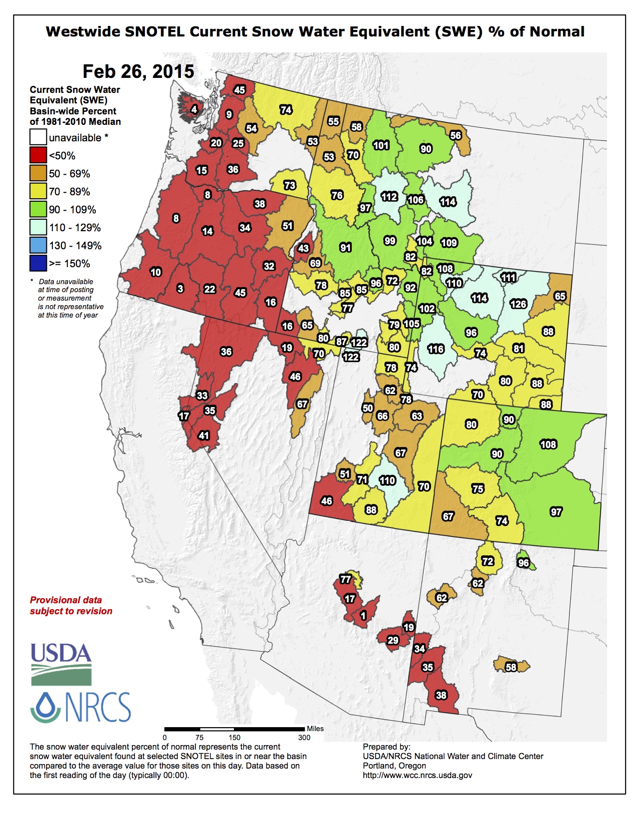
Click on a thumbnail below to view a gallery of snowpack data for February 25, 2015 from the NRCS.

Statewide snowpack February 25, 2015 via the NRCS

Arkansas River Basin High/Low Graph February 25, 2015 via the NRCS

Upper Colorado River Basin High/Low Graph February 25, 2015 via the NRCS

Gunnison River Basin High/Low Graph February 25, 2015 via the NRCS

Laramie and North Platte Basin High/Low Graph February 25, 2015 via the NRCS

Upper Rio Grande River Basin High/Low Graph February 25, 2015 via the NRCS

San Miguel, Dolores, Animas, and San Juan Basin High/Low Graph February 25, 2015 via the NRCS

South Platte River Basin High/Low Graph February 25, 2015 via the NRCS

Yampa and White Basin High/Low Graph February 25, 2015 via the NRCS
The current snowpack for the Roaring Fork Watershed is down to 78% of normal. Even with the recent new snow, the snowpack continues to be…
— RoaringFkConservancy (@rfconservancy) February 26, 2015
Drought news: Above normal precip for parts of the Southwest and Rockies

US Drought Monitor February 24, 2015

West Drought Monitor February 24, 2015

Colorado Drought Monitor February 24, 2015
Click on a thumbnail graphic for a gallery of drought data from the US Drought Monitor.
Click here to go to the US Drought Monitor website. Here’s an excerpt:
Summary
The upper-level circulation pattern during this U.S. Drought Monitor (USDM) week was dominated by a strong trough over the eastern CONUS (contiguous United States) which funneled cold air masses into the central and eastern United States. Storm systems moving along the southern edge of the trough generated a wintry mix of weather, dumping locally heavy rain and snow from the Lower to Mid-Mississippi Valley on the western end to the Mid-Atlantic coast in the east, improving drought conditions … especially in the Mississippi and Ohio Valleys. The precipitation mostly missed the immediate Gulf of Mexico coastal areas, where drought expanded. An upper-level low pressure system moved across the ridge over the western CONUS and settled in over the Southwest near the end of the week, with above-normal precipitation falling across parts of the Southwest and Rocky Mountains. The week was drier than normal in the Pacific Northwest and much of the Intermountain Basin, where drought expanded. Temperatures in the West averaged above normal this week, but the anomalies were not as warm as in previous weeks…
The Northern Plains and Midwest
Most of the Central to Northern Plains and Upper Midwest were drier than normal this week, with some areas receiving no precipitation. Precipitation deficits in the Northern Plains to Upper Mississippi Valley continued to mount, exceeding 4 inches over the past 6 months in parts of the Dakotas and Minnesota. But winter is the dry season, and deficits during this time of year are less significant than during the warm season. The drier-than-normal autumn depleted soil moisture and set the state for potential spring concerns, and the current depiction of D0-D1 adequately represents this situation. With temperatures this week continuing well below normal and the ground remaining frozen, no change to the depiction was made in this area.
To the south, a major winter storm moved across the Tennessee and Ohio Valleys, dumping an inch or more of precipitation, mostly in the form of snow, across a wide area, with locally 3 inches or more in parts of southern Kentucky. The precipitation raised stream levels, replenished soil moisture, and erased precipitation deficits for the last 30 days. As a result, D0-D1 were pulled back in Kentucky and the Missouri bootheel. But significant deficits remained at the 60-90 day time scale, so areas of D0 and D1 remained to represent these longer-term conditions. Low stream levels along and north of the Ohio River remained a concern, but no expansion of D0 was made here due to the area receiving above-normal precipitation this week…
The Southern Plains to Southeast
A major winter storm system moved across the Lower to Mid-Mississippi Valley and Southeast during the middle of this USDM week, followed by another system at the end of the week which moved out of the Southern Plains and across the Southeast. These systems left a total of 1-3 inches of precipitation across an area stretching from northeast Texas to the Carolinas, with locally 3-5 inches in parts of Tennessee and northern Mississippi, replenishing soil moisture and filling streams. D0-D2 contracted in Tennessee, northern Mississippi, and adjacent Arkansas. A remnant of D1 remained in western Tennessee, and D1-D2 remained in northeast Arkansas, to reflect the continued significant precipitation deficits which remained over the last 3 to 5 months. The precipitation was enough to prevent further deterioration in northern Alabama to the Carolinas, but not enough to warrant improvement in the drought depiction. The storm systems mostly missed the Gulf of Mexico coastal areas, which generally received less than half an inch of moisture. D1 expanded from southern Louisiana to southern Alabama and the Florida panhandle where weekly precipitation was below normal and deficits continued to mount. Much of this area has very low streamflow levels and precipitation deficits exceeding 6 inches, and locally 9 inches, since the beginning of October.
In Texas, above-normal precipitation at the 7-day to 6-month time scales prompted the pullback of D2-D3 in the northwest corner of the panhandle, while D2-D3 expanded in south-central Texas near the Edwards Plateau. Deeper soil moisture, stock ponds, rivers, and reservoirs in western Oklahoma have never fully recovered from the drought which began 4 years ago. The Washita River has been completely dry for nearly the last 4 years, which local residents say is highly unusual, with the river generally not being without water for more than 90 days in the past. NASA satellite-based measurements of groundwater indicated severely dry conditions in western Oklahoma. D3 was expanded in western Oklahoma across Roger Mills, Custer, Beckham, and Washita Counties to better reflect long-term moisture deficits (over the last 15 to 72 months) as well as record low streamflow levels. D1-D3 were expanded in north central Oklahoma, and D1 in adjacent south central Kansas, where 7-day to 6-month precipitation deficits were greatest and surface water supplies continued to be a concern…
The West
It was another dry week for much of the West, with parts of the Pacific Northwest, Northern California, Arizona, New Mexico, and the Intermountain Basin receiving no precipitation. Scattered areas of the Pacific Northwest and Northern Rockies received half an inch to an inch of precipitation. A slow-moving upper-level weather system brought half an inch to 2 inches of precipitation to parts of Southern California and the Southwest, with 2-4 inches being reported over southwest Colorado. In California, D4 was pulled back in eastern Kern County and adjacent southeast Tulare County, but otherwise The Golden State remained locked in a years-long drought. At the University of California-Berkeley’s Central Sierra Snow Laboratory site near Donner Summit, there was only about a foot of snow on the ground, which is lower for late February than all of the dry winters in the last 70 years. Snow depth at this site never got above 3 feet this winter, when their usual maximum depth would be around 12 feet.
Mountain snowpack remained well below normal, not just in California but all across the Cascades, Sierra Nevada, and Intermountain Basin. The SNOTEL network snow water content ranked among the driest 5 percentile in the historical record for much of this area, with many SNOTEL sites unusually snow free this early in the season. The low mountain snowpack will significantly affect spring and summer water supplies, as melting of the mountain snowpack provides an important water source during the warm season. Mountain snow water content was above normal in only a few parts of the Northern and Central Rockies. D1 expanded along the southern Cascades of Washington, and was added to the Olympic Mountains, to reflect the low snowpack. D1-D3 expanded in southwest Idaho (Owyhee and Canyon Counties) to reflect basin impacts. D0 expanded in southeast Idaho and into southwest Montana and northwest Wyoming (in the vicinity of Yellowstone National Park) where streamflow levels, snow water content, and water-year-to-date precipitation were low. Mountain snow water content and water-year-to-date precipitation were well below normal in northwest Utah to southwest Wyoming. Even though up to an inch of precipitation was observed this week in southwest Utah, NASA satellite-based measurements of groundwater indicated very dry conditions from southwest Utah to southwest Wyoming. As a result, D1 expanded across southwest Utah, D0-D1 expanded in northeast Utah into southwest Wyoming, D2 expanded in northwest Utah, and a spot of D3 was added to northwest Utah…
Looking Ahead
The upper-level circulation pattern (of ridge west/trough east) will undergo a change in the next 7 days. Weather systems will undermine the western ridge, allowing colder-than-normal air to spread westward and encompass most of the CONUS. Some precipitation (a tenth of an inch or more) is expected to fall across most of the CONUS during February 26-March 3. An inch or more is forecast for parts of the Pacific Northwest, Southwest, and Southern to Central Rockies, and for most of the country from the eastern Plains to the East Coast. The eastern storm track is predicted to bring 2 or more inches of precipitation to the Mid-Mississippi Valley to Ohio Valley and Southern Appalachians, as well as the Coastal Carolinas. The driest areas are expected to be the Northern Plains, southwest Texas, and parts of California.
The 6-10 day and 8-14 day outlooks keep the area of below-normal temperatures across most of the CONUS, with only the extreme Southeast, as well as Alaska, warmer than normal. The greatest chances for above-normal precipitation during March 2-10 are expected to be over Alaska and the eastern third of the CONUS. Below-normal precipitation is expected over the West and Northern Plains, spreading across the Rockies and into the Midwest later in the period.
Happy 96th birthday @GrandCanyonNPS
Happy 96th birthday @GrandCanyonNPS! pic.twitter.com/H9rsp5uYz9
— National Park Service (@NatlParkService) February 26, 2015
Hoover Dam’s cobwebbed spillway — John Fleck

Hoover dam spilling

Hoover Dam during construction

Rarely seen back of the Hoover Dam prior to first fill

Hoover Dam during construction

Colorado River, Black Canyon back in the day, site of Hoover Dam

A full Lake Mead back in the day
From InkStain (John Fleck) (Click through for the photo):
Erika Moonin, the Southern Nevada Water Authority’s engineering project manager for construction of the agency’s new Lake Mead intakes, showed me a picture yesterday of water pouring over Hoover Dam’s spillways in 1983, the last time the reservoir spilled. When she was a youngster, her dad took her out to see the spectacle. Looking at it today, it’s hard to imagine. Current lake level is 137 feet below the 1983 peak…
* I didn’t actually see cobwebs. It’s literary license.
More Colorado River Basin coverage here.
Bureau of Reclamation: This map shows where invasive mussels have infested or been detected in our reservoirs or facilities
This map shows where invasive mussels have infested or been detected in our reservoirs or facilities #InvasiveSpecies pic.twitter.com/OfLRA9J8Px
— Bureau of Reclamation (@usbr) February 24, 2015
More invasive species coverage here.
City report examines Poudre River’s health — the Fort Collins Coloradoan

From the Fort Collins Coloradoan (Sarah Jane Kyle):
A report released by the city of Fort Collins could help define the Poudre River’s ecological future.
The Poudre River Ecological Response Model (ERM), which was created to understand possible future scenarios for the river, covers a 13-mile stretch of river through Fort Collins, from Overland Trail to Interstate 25.
A panel of river ecology experts will present the project to the public Thursday. Natural Areas Department Director John Stokes said the report identifies some challenges the urban river faces, as well as possible solutions.
“I think as a community we need to have a discussion about how much change is acceptable and what we can do to help this river feel like a river,” he said. “That’s going to be challenging because there are a lot of demands on the Poudre River.”
Stokes said the Poudre River in Fort Collins is “very much entrenched,” which has limited the river’s ability to function naturally.
“We’ve put the river in its place and it stays there,” he said. “If we can let the river move around or do some over-bank flooding where it’s safe, that gets back some of the ecological function we’ve lost over the last 100 years.”
The ERM offers 27 responses for four indicators of the river’s condition: physical setting, aquatic life, fish and riparian habitats. The report was a collaborative effort featuring nine team members from Colorado State University, U.S. Forest Service, The Nature Conservancy, U.S. Geological Survey and city of Fort Collins.
Research began in 2011 and was finalized late last year. Stokes said the ERM will serve “as a guide post and decision support tool” for future conservation and river health efforts.
“It doesn’t tell us exactly what to do,” he said. “But it helps us understand the river.”
Learn more
•Learn more about the Poudre River Ecological Response Model in a panel presentation from 4 to 5 p.m. Thursday at Colorado State University’s Lory Student Center.
•See the report at http://fcgov.com/naturalareas/eco-response.php.
More Cache la Poudre River coverage here.
Noontime Nature lecture, “The Story of Getting There” at the Loveland Public Library, March 3 and 4

John Wesley Powell at his desk—same desk used by the USGS Director today via the USGS

John Wesley Powell

John Wesley Powell’s recommendation for political boundaries in the west by watershed

John Wesley Powell
From the Loveland Reporter-Herald (Kevin J. Cook):
John Wesley Powell earned his fame twice: once for taking a direct hit from a cannon during the Civil War and once for passing through the Grand Canyon on a boat. The first made the second seem all the more remarkable.
But Powell was a remarkable person.
His mind was so eclectic that had his thoughts been light they would have been a rainbow. His ideas were like so many brilliant and distinctive hues; his ambitions were like so many gradations.
This trio of diversity, ideas and ambitions was simultaneously his strength and his weakness, a conflict that would stymie a lesser man.
Powell was the quintessential 80-percenter. He had the passion to pursue his ideas, but he only had the drive to get them going. Once one of his ideas was underway with a substantial measure of progress — 80 percent done — his heart and mind turned to the next idea leaving the previous project for others to direct and to complete.
And the one project for which he is best remembered is one that others finished, for Powell did not boat the Grand Canyon alone. Yet few can name those who ran the river with him. The leader gathers the glory.
Another tidbit also gets little attention: To get from Illinois to the Grand Canyon, he passed through Colorado. In other words, to get there he traveled here.
On July 8, 1868, Powell and his troupe known as the Rocky Mountain Scientific Exploring Expedition crossed into Colorado from Cheyenne, Wyo. They spent the summer engaging Colorado’s mountains and passes, parks and rivers.
Rather than passing through like so many sightseeing travelers, they came to engage this young territory. Powell intended to document what others knew but did not preserve in the language of maps.
Anyone could hire the guide services of a man like Kit Carson, but Carson was an illiterate who was good on the ground but incapable of preserving or passing on what he knew.
Powell put Colorado on the map; Powell put the map on Colorado.
Some people might argue that Powell’s time in Colorado was inconsequential because his work here was eclipsed by the trip through the Grand Canyon. A better argument would be that he made it through the Grand Canyon because he made it through Colorado.
Powell’s experiences in Colorado prepared him for the challenges that filled his life as a dreamer and a realist, as a conservationist before the word was coined, as an anthropologist and as a reluctant but motivated politician.
In Colorado John Wesley Powell found his muse.
If you go
The Noontime Nature lecture, “The Story of Getting There” at the Loveland Public Library, 300 N. Adams Ave., will be presented twice on Tuesday, March 3: noon to 1 p.m. and again 2 to 3 p.m. and will be repeated 6 to 7 p.m. on Wednesday, March 4. Third in a free year-long series about nature writing specific to Colorado sponsored by Friends of the Loveland Library, “Getting There” will feature John Wesley Powell’s passage through Colorado in the summer of 1868, as presented in Wallace Stegner’s book, “Beyond the Hundredth Meridian.”