“Central Valley…groundwater pumping…the very definition of unsustainable” — The Mountain Town News

Groundwater movement via the USGS

From The Mountain Town News (Allen Best):

To grasp the immensity of the groundwater pumping in California during the last century, think back to the last time you flew into Las Vegas. Before descending into McCarran International Airport, you may have swept across Lake Mead. When full, the reservoir is 112 miles long and up to 532 feet deep. It can hold up 28 million acre-feet of water, or about two average-year flows of the Colorado River before diversions.

That, according to the Los Angeles Times, is how much water has been removed from California’s Central Valley since the advent of groundwater pumping. It’s staggering, the very definition of unsustainable.

Groundwater depletion is a problem not just in California, but across the country. Resources created during geologic timescales are being depleted in human lifetimes for cities and farms. In the United States, 14 percent of all water used to irrigate crops comes from mining groundwater aquifers.

Cheap energy and advances in pumping technology around the end of World War II accelerated this depletion. We have gained the artifice of cheap food and irrigated luxuriance in arid environments. The extraction of water above the rate of recharge is now close to 400 cubic kilometers.

“We are robbing our savings account,” says Andrew Stone, executive director of the American Ground Water Trust. Stone points out that population growth and the uncertain effects of climate change will apply more pressure to these subterranean savings accounts.

It’s not inevitable that we pinch these piggy banks until they’re empty. Los Angeles after World War II turned to groundwater exploitation to satisfy growth. But over time it was able to shift to other mechanisms, including recycling, to meet population needs.

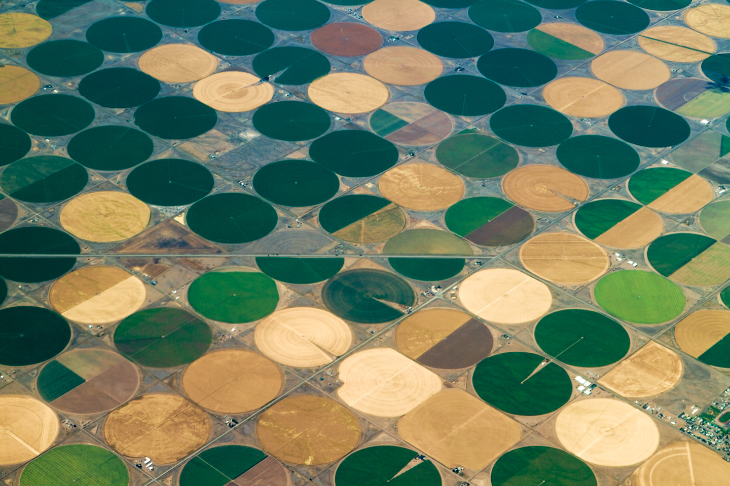
Agriculture regions have been slower to adapt. The Central Valley has been Exhibit A in groundwater mining for many decades. It’s 450 miles up and down and, at a maximum, 60 miles wide and wonderfully productive. One-eighth of total agriculture production in the United States occurs here on 1 percent of the land. From avocados to artichokes, potatoes to peppers, much of your grocery store’s produce likely comes from the Central Valley. “Everyone eats there,” as a headline in the New York Times Magazine noted several years ago.

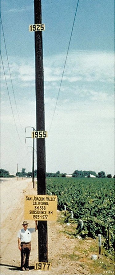
Snowmelt from the Sierra Nevada provides some of the water for the crops, but aquifers have allowed the great expansion of farming. This is mining, and similar to mining for ores, aquifer pumping can cause the earth itself to subside. One famous photograph taken in California’s Central Valley in the 1970s of a tall telephone pole showed the extent of subsidence, nearly 30 feet at that point.

sanjoaquinvalleysubsidenceusgs

Soon after that photograph was taken, proposals to methodically address groundwater depletion were laid on the desk of California’s handsome young governor, Jerry Brown. It went nowhere. The issue was too fractious in California then. Only baby steps were taken over the next several decades.

Other states in the West have been more aggressive in adopting state-wide regulation. Colorado’s regulations, for example, were adopted in the late 1960s. They haven’t been a cure-all. Unsustainable extraction of the Ogallala aquifer continues. Denver’s fast-growing southern suburbs, with some of the wealthiest and best-education demographics in the country, depend almost 100 percent on rapidly declining aquifers.

There is no one answer to this unsustainable aquifer mining. Certainly, increased recycling will be one response, as it has been in Los Angeles and soon will be in Denver’s south suburbs. We’ll have to revise our expectations of landscaping, and continue to tinker with how technology can make more efficient use of our supply.

In California, Gov. Brown, now bald and in his 70s, last September signed a trio of laws that together give local jurisdictions tools for planning how to achieve sustainability by 2040. Sustainability here is defined as aquifers recharging, through percolation or direct injection, as rapidly as they are withdrawn. But the laws also reserve a big stick. If local jurisdictions don’t, the state eventually will elbow into local affairs to get the planning done.

Recycling alone can’t alone be the answer for California’s Central Valley or other regions west of the 100th meridian so utterly dependent upon mining of aquifers. Fundamentally, our cheap food, like our cheap energy, is an illusion.

A century ago, hard-rock miners were still making a mess of the West, clawing out high-value minerals and creating the acid-mine drainage, now a significant problem and expense. Ignorance perhaps excuses their actions. With groundwater mining, we have no excuse. We already know we’re on unstable ground.

More groundwater coverage here.

2015 Colorado legislation: HB15-1167 (South Platte River Mainstem Storage Study)

South Platte River Basin via Wikipedia

HB15-1167 is up for hearing tomorrow in the House Agriculture, Livestock, & Natural Resources committee. The bill is the brainchild of J. Paul Brown representing District 59 down in southwestern Colorado. It would direct the CWCB to study the feasibility of new mainstem storage on the South Platte River downstream from Greeley. It also directs the CWCB to utilize existing studies of the possibility of pumping water from the Missouri River Basin back to Colorado. I suppose he’s talking about the USACE’s alternative to Aaron Million’s pipeline from the Green River or the Kansas Aqueduct project.

The bill calls out the Narrows Dam Project (650,000 AF) that was authorized by the US Congress but never built for a number of reasons, most of which would be faced by any new mainstem project.

Senator Sonnenberg shows up as the Senate sponsor.

Here’s what Representative Brown had to say on the subject in the Pagosa Daily Post:

My time in the legislature is challenging and exciting. I am working hard on my bills as well as keeping up on my committee bills and the bills that come to the floor. I actually have a little advantage over other legislators in that my apartment is half a block from the Capitol, so all of my time, when I am not sleeping, showering, or attending receptions, is spent reading and preparing for action on bills.

My number one issue is water storage and primarily storage in the South Platte drainage in Colorado. Why on the South Platte? Because that is the one drainage on the eastern side of Colorado that regularly has water that leaves the state that can legally be stored and used in Colorado. When I was in the legislature in 2011 and 2012 I started paying attention to the water in the South Platte Basin that was leaving the state. There were two years in particular where over 1,000,000 acre feet per year were wasted, another where 600,000 acre feet left the state, and even today there is excess water running out of the state that could be used to augment other water needs in Colorado. If we could store that water, it would help to satisfy the demand on the Front Range and relieve the need to send water from the Western Slope to the more populated Eastern side of the Continental Divide.

For the past many years I have been learning all I can about water, water law, water compacts with other states, and everything else related to water that I could possibly learn. I started at a young age when my parents were paid to measure the water at the Colorado/New Mexico state line on the La Plata River South of Hesperus, Colorado. On most early mornings before I caught the bus for school I would measure the amount of water in the river. That information was then relayed to the water authorities in both states where ditches were closed or opened depending on their priority. I have monitored Governor Hickenlooper‚s „water plan‰ and have attended as many Water Roundtable meetings as I could possibly make. I have attended the Colorado Water Congress meetings amongst the most knowledgeable water lawyers and providers in Colorado.

I still have much to learn.

Everywhere I go I have asked folks about storage on the South Platte. The more I have learned, the more it became evident that all of the information needed to make good decisions on where and how to store water was scattered in many different places. I decided that it was necessary to pull all of that information together and that the easiest way to do so is to run a bill. That bill is HB15- 1167. It will be heard in the House Agriculture, Livestock, and Natural Resources Committee upon adjournment on the 18th of February.

More 2015 Colorado legislation coverage here.

Wyoming reconsiders cloud seeding and potential benefits for ag

More cloud seeding coverage here.

Great interview with Nolan Doesken on the role of State Climate Offices in communicating climate — Dave DuBois

@USGS: Largest Dam Removal in U.S. History Scientifically Characterized

Here’s the release from the United States Geological Survery:

The effects of dam removal are better known as a result of several new studies released this week by government, tribal and university researchers. The scientists worked together to characterize the effects of the largest dam removal project in U.S. history occurring on the Elwha River of Washington State. New findings suggest that dam removal can change landscape features of river and coasts, which have ecological implications downstream of former dam sites.

“These studies not only give us a better understanding of the effects of dam removal, but show the importance of collaborative science across disciplines and institutions,” said Suzette Kimball, acting director of the U.S. Geological Survey.

Five peer-reviewed papers, with authors from the U.S. Geological Survey, Reclamation, National Park Service, Washington Sea Grant, NOAA Fisheries, the Lower Elwha Klallam Tribe, and the University of Washington, provide detailed observations and insights about the changes in the river’s landforms, waters and coastal zone during the first two years of dam removal. During this time, massive amounts of sediment were eroded from the drained reservoirs and transported downstream through the river and to the coast.

One finding that intrigued scientists was how efficiently the river eroded and moved sediment from the former reservoirs; over a third of the 27 million cubic yards of reservoir sediment, equivalent to about 3000 Olympic swimming pools filled with sediment, was eroded into the river during the first two years even though the river’s water discharge and peak flows were moderate compared to historical gaging records.

This sediment release altered the river’s clarity and reshaped the river channel while adding new habitats in the river and at the coast. In fact, the vast majority of the new sediment was discharged into the coastal waters of the Strait of Juan de Fuca, where the river mouth delta expanded seaward by hundreds of feet.

“The expansion of the river mouth delta is very exciting, because we are seeing the rebuilding of an estuary and coast that were rapidly eroding prior to dam removal,” said USGS research scientist and lead author of the synthesis paper, Dr. Jonathan Warrick.

Although the primary goal of the dam removal project is to reintroduce spawning salmon runs to the pristine upper reaches of the Elwha River within Olympic National Park, the new studies suggest that dam removal can also have ecological implications downstream of the former dam sites. These implications include a renewal of the sand, gravel and wood supplies to the river and to the coast, restoring critical processes for maintaining salmon habitat to river, estuarine and coastal ecosystems.

“These changes to sediment and wood supplies are important to understand because they affect the river channel form, and the channel form provides important habitat to numerous species of the region,” stated USGS research scientist and river study lead author, Dr. Amy East.

The final stages of dam removal occurred during the summer of 2014. Some sediment erosion from the former reservoirs will likely continue. The Elwha Project and research teams are continuing to monitor how quickly the river returns to its long-term restored condition.

“We look forward to seeing when the sediment supplies approach background levels,” said Reclamation engineer and co-author, Jennifer Bountry, “because this will help us understand the length of time that dam removal effects will occur.”

The five new papers can be found in Elsevier’s peer-reviewed journal, Geomorphology, and they focus on the following topics of the large-scale dam removal on the Elwha River, Washington (web-based publication links using digital object identifiers, doi, are provided in parentheses):

  • Erosion of reservoir sediment
  • Fluvial sediment load
  • River channel and floodplain geomorphic change
  • Coastal geomorphic change
  • Source-to-sink sediment budget and synthesis
  • More USGS coverage here.

    The Colorado College State of the Rockies Project releases the 2015 Conservation in the West Poll

    consesrvationinthewestpoll2015stateoftherockies

    Click here to go to the State of the Rockies Project website to read the report. Here’s an excerpt:

    The 2015 Conservation in the West Poll, now in its fifth year, was recently released by Colorado College’s State of the Rockies Project. The survey of 2,400 registered voters in six western states provides an annual glimpse of voters’ leanings on land use, water supplies, the impact of public lands on the economy, and a variety of other related issues.

    Designed by a bipartisan team of Republican and Democratic opinion researchers, the annual poll provides insight into Western attitudes. This year’s results are consistent with those of previous years, although a few new questions probed opinions of public-land management and the perceived relationship between environment and quality of life.

    Four hundred residents in each state – Arizona, Colorado, Montana, New Mexico, Utah, and Wyoming – were asked about such issues as conservation, environment, energy, the role of government, trade-offs with economies, and citizen priorities.

    The poll, conducted Dec. 29, 2014 and Jan. 3-11, 2015, has a margin of error of 4.9 percent.

    Here’s an excerpt from the Colorado poll:

    Colorado15stateoftherockies

    Snowpack news: Some areas of Colorado received a foot or more of snow from the recent storm

    westwidesnotel02152015

    From the Associated Press via the Glenwood Springs Post Independent:

    A storm dropped more than a foot of snow on parts of the Colorado mountains Monday and left some roads in Denver and Colorado Springs glazed with ice for the morning commute.

    The Western Slope, meanwhile, continued its dry stretch, with Aspen Mountain and Sunlight Mountain getting only an inch of new snow.

    Eldora Mountain Resort near Boulder reported 15 inches of new snow. Breckenridge and Winter Park ski areas reported 7 inches.

    The National Weather Service said 13 inches fell near St. Marys Glacier in Gilpin County in the mountains west of Denver…

    The statewide snowpack, which accounts for much of Colorado’s water, stood at 81 percent of the 30-year average before the storm hit.

    Snow depth in the South Platte, Arkansas and Colorado river basins ranged from 91 to 102 percent of average, while the southwest corner of the state remained locked in a drought, with snowpack at 60 percent to 75 percent of average.

    The northwest corner of the state had about 85 percent of average snowpack.

    https://twitter.com/martyconiglio/status/567667769965948929

    From the USDA via the High Plains/Midwest Ag Journal:

    An unusually warm, dry January slowed snowpack accumulation in much of the West, according to data from the second 2015 forecast by the United States Department of Agriculture’s National Water and Climate Center. California, Arizona and New Mexico, as well as parts of Colorado, Utah, Oregon and Nevada, remain in prolonged drought.

    “January is usually a big month for snowpack accumulation,” NWCC hydrologist Cara McCarthy said. “But most of the West didn’t see significant gains this month. With isolated exceptions, only Arizona, New Mexico, Utah and Montana received near average precipitation last month.”

    “This is as low a snowpack as I’ve seen across the Sierra Nevada and Cascades for many locations at this time of year,” said NWCC Director Mike Strobel. Several Snow Telemetry sites in those ranges are snowless, which is very unusual for this time of year.

    Even the precipitation in the Southwest wasn’t enough to take these regions out of drought conditions. In Western states where snowmelt accounts for the majority of seasonal water supply, information about snowpack serves as an indicator of future water availability. Streamflow in the West consists largely of accumulated mountain snow that melts and flows into streams as temperatures warm in spring and summer. NWCC scientists analyze the snowpack, air temperature, soil moisture and other measurements taken from remote sites to develop the water supply forecasts.

    The Cascades of Oregon and Washington have received normal levels of precipitation this water year, but it’s mostly fallen as rain instead of snow. California’s Sierra Nevada has seen little rain or snow. The extreme drought in California may be further aggravated by reduced streamflow in other parts of the West.

    “This month the inflow forecast for Lake Powell fell from 90 to 70 percent of normal,” said McCarthy. “Because southern California draws water from the Colorado River, this may impact their water supply. This is only the second forecast of the season, and there’s still time for conditions to change. We’ll keep watching conditions and updating our forecasts as the year continues.”

    The NWCC, part of USDA’s Natural Resources Conservation Service, monitors conditions year-round and will continue to issue monthly forecasts until June. The water supply forecast is part of several USDA efforts to improve public awareness and mitigate the impacts of climate change, including drought and other extreme weather events. Through the creation of the National Drought Resilience Partnership, launched as part of the president’s Climate Action Plan, federal agencies are working closely with states, tribes and local governments to develop a coordinated response to drought.

    Since 1939, USDA has conducted snow surveys and issued regular water supply forecasts. Other resources on drought include the U.S. Drought Monitor. For information on USDA’s drought efforts, visit USDA Disaster and Drought Information. To learn more about how NRCS is helping private landowners deal with drought, visit the NRCS’ drought resources.

    View information by state at http://www.wcc.nrcs.usda.gov/BOR/state_outlook_reports.htm.

    2015 Colorado legislation: Colorado Corn Growers support 3 more bills #coleg

    Crop circles -- irrigated agriculture
    Crop circles — irrigated agriculture

    From Colorado Corn Growers via the High Plains/Midwest Ag Journal:

    The Colorado Corn Growers Association’s Public Policy Committee voted recently to put its support behind three more bills during the 2015 Colorado Legislative Session, bringing the total number of bills the group is supporting to six.

    These bills focus on a variety of issues, covering pesticide applicator rules, mineral rights, road regulations, water and renewable energy.

    Meanwhile, the group is monitoring a number of other bills, and considering support or opposition for those as well, as the 2015 Colorado Legislative Session moves forward.
    The three bills that CCGA’s Public Policy Committee most recently voted to support include:

    • Senate Bill 15-119, “Sunset Pesticide Applicator”—The existing Colorado Pesticide Applicator Act expires in September of this year. This bill would renew the Pesticide Applicator Act, and also implement recommendations made by the Colorado Department of Agriculture.

    • Senate Bill 15-093, “Compensate Owners Min Interests Extraction Regs”—Whenever a local government adopts or implements an ordinance, resolution, rule or regulation concerning mineral extraction that would reduce the fair market value of the owner’s mineral interest by at least 60 percent, this bill would specify that owner’s interest is deemed to have been taken for public use. This bill would then allow the impacted mineral owners to obtain compensation from the local government for the full diminution in the fair market value of the owner’s interest caused by the regulatory impairment.

    • Senate Bill 15-023, “Off-highway Vehicle State Highway”—Currently, off-highway vehicles may cross streets, roads or highways if the driver complies with certain snowmobile statutory standards. This bill would import the snowmobile standards into the off-highway vehicle statutes. The bill also clarifies that a driver may cross a state highway if the driver complies with these standards.

    Learn more about these bills and others that the Colorado Corn Growers Association is following at http://coloradocorn.com/public-policy/position-summary.

    More 2015 Colorado legislation coverage here.

    @TheEconomist: Arctic ice is melting fast, and the sea is duly awakening. This is good, bad, and unstoppable.

    Steamboat Springs: The city and Yampa Valley Housing Authority collaborate on project

    Steamboat Springs
    Steamboat Springs

    From Steamboat Today (Tom Ross):

    The city of Steamboat Springs and the Yampa Valley Housing Authority are advertising for bidders on a water and sewer project in Fish Creek Mobile Home Park that would combine replacement of the city’s sanitary sewer interceptor that happens to run through the park, while accomplishing a much needed replacement of water and sewer lines to park’s 67 mobile homes.

    “Talk about a partnership — the city has been terrific,” Housing Authority Board Chairwoman Kathi Meyer said Monday. “The city’s departments that do the bid work and public works have been very helpful in putting this together.”

    Combining the city’s sewer interceptor project with water and sewer line replacement for the homes in the mobile home park, which is owned and managed by the Housing Authority, represents an economy of scale, Meyer said. It will allow the successful bidder to stage the job site once for both jobs and avoid incurring the extra expense of disrupting homeowners’ driveways and retaining walls twice.

    Replacement of the city sewer interceptor already was on its list of prioritized capital projects. Merging the two projects required multiple departments having the will to “figure out how do we do it?” Meyer added.

    The city loaned the Housing Authority $954,000 in 2007 to help with purchase of the mobile home park from Bob and Audrey Enever, who had owned it for 33 years. The Housing Authority took out an additional bank loan of $2.58 million, counting on lot rent to cover the debt.

    Everyone involved understood that the park’s infrastructure was aging and required frequent repairs, but the Housing Authority’s cash flow was tied up with debt service.

    Three years ago, the Authority’s consulting engineering firm, Drexel Barrell, informed the board that it needed to replace the water and sewer lines.

    “We knew it was original infrastructure. Some of the sewer lines run underneath the homes,” Meyer said. “Over the last eight years, there have been ongoing maintenance issues. We’ve been lucky that although breaks over the last few years have caused inconvenience to tenants, there hasn’t been a significant incident.”

    Fortunately, prevailing lending terms allowed the board to refinance the original bank loan, this time with Alpine Bank, at a lower interest rate. The freed-up revenue stream allowed the Housing Authority to leverage a loan through the Colorado Water Resources and Power Development Authority to fund the water and sewer work.

    “The stars aligned,” Meyer said, securing an important source of workforce housing in the community for perhaps another 50 years or so.

    More infrastructure coverage here.

    Norwood: Lawn and garden irrigation project awaits CWCB funds for feasibility study

    Lone Cone from Norwood
    Lone Cone from Norwood

    From The Norwood Post (Regan Tuttle):

    At February’s Norwood town board meeting, trustees discussed the Colorado Water Conservation Board’s upcoming decision on a grant award that Norwood recently applied for. The funding would make possible a feasibility study that will determine whether or not Norwood should move forward with a lawn and garden raw water irrigation project, similar to that of Dove Creek.

    Last month, town officials met with those of Dove Creek to learn the details of the project.

    Town Administrator Patti Grafmyer said that receiving the grant would not mean that the irrigation project will automatically move forward.

    “Norwood can evaluate the feasibility study,” she said. “We are just asking for the funding, but once that has happened, there will be a scope of work that will have to be signed with the town board.”

    CWCB members will make the decision this March.

    More San Miguel River watershed coverage here.