After warm, dry January, @usbr trims 1.2 million acre feet from its forecast for Lake Mead and Lake Powell for 2015: http://t.co/EIUyNmIUYf
— John Fleck (@jfleck) February 12, 2015


After warm, dry January, @usbr trims 1.2 million acre feet from its forecast for Lake Mead and Lake Powell for 2015: http://t.co/EIUyNmIUYf
— John Fleck (@jfleck) February 12, 2015
Small scale #hydropower enjoys #bipartisan support. This @NewsHour story features Silverton,CO http://t.co/tlyoHbfQO6 pic.twitter.com/hD191q5tsW
— Rep. Diana DeGette (@RepDianaDeGette) February 12, 2015
#WaterNews: New @USGS report says US ground #water polluted by farms & urban area http://t.co/vJSouavmnc @waltonwater pic.twitter.com/CJP4rA5y6R
— Circle of Blue (@circleofblue) February 12, 2015


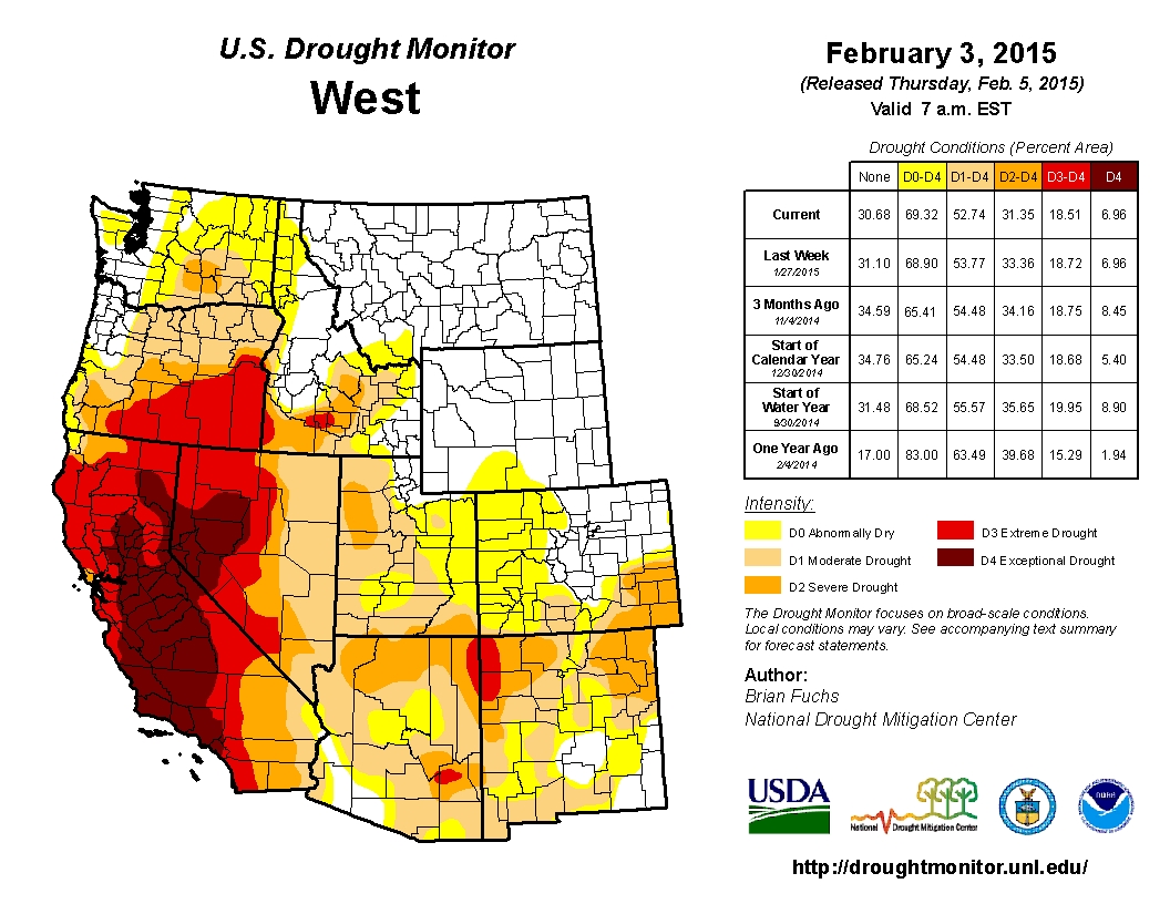
Click on a thumbnail graphic to view a gallery of drought data from the US Drought Monitor. Here’s an excerpt:
Summary
This U.S. Drought Monitor week saw improvements along the West Coast as a series of strong Pacific storms produced substantial rainfall accumulations in northern California and western portions of Oregon and Washington. The storms were the first significant precipitation event to affect California since mid-December. Since the moisture associated with these storms was subtropical in origin, the vast majority of the precipitation fell as rain while snowfall was restricted to the higher elevations. Overall, the storms had little impact on the well-below-normal snowpack conditions across the Sierra Nevada and Cascades ranges. Elsewhere in the West, mountain snowpack conditions are currently below normal across the Great Basin and Southwest as well as in parts of the Intermountain West and Central Rockies. Reservoir storage remains below normal in Arizona, California, Nevada, New Mexico, Oregon, and Utah in contrast to slightly above average conditions in Colorado, Idaho, Montana, Washington, and Wyoming. Temperatures during the past week were well above normal in the western half of the conterminous U.S. with record high temperatures observed across the West and Central Plains. In contrast, the Northeast remained in a cold, snowy pattern with areas of Massachusetts, New York, New Hampshire, and Vermont receiving more than a foot of new snowfall…
The Plains
Across the northern and southern Plains states, temperatures were well above normal for the period. During the weekend, record high temperatures were observed in Kansas and South Dakota. In western Kansas, temperatures soared into the high 70s and low 80s, while portions of South Dakota reached the mid-60s. On this week’s map, changes included expansion of Abnormally Dry (D0) into western South Dakota in response to above normal temperatures and precipitation deficits during the past 30 days. In southeastern Kansas, some minor expansion in an area of Moderate Drought (D1) occurred in response to warmer temperatures and deterioration in local stock pond levels…
The West
During the past week, a series of strong Pacific storms came ashore late last week and continued throughout the weekend. This storm system – which tapped a conveyor-belt of warm, moist air from the subtropics – delivered widespread, heavy rainfall to northern California and the western portions of Oregon and Washington. In northern California, liquid precipitation accumulations ranged from three-to-fifteen inches, with the highest accumulations centered over the mountains of northwestern and north-central California as well as further south in the Santa Cruz and Santa Lucia ranges. In the northern half of the Sierra Nevada Range, rainfall accumulations ranged from three-to-ten inches, and the greatest accumulations occurred on the western slope between 2000 and 7000 feet in elevation. Snow levels were generally high (above 8000 feet) throughout the storms, and the cumulative effect of the snowfall received did not have a significant impact on the poor snowpack conditions across the range. According to the California Department of Water Resources, California’s snowpack (snow water equivalent) is currently at 27% of normal. On a more positive note, runoff associated with the event provided the addition of approximately 500,000 acre feet of inflow to the four major reservoirs (Folsom, Oroville, Shasta, and Trinity) in northern California. In response to the storm, a one-category improvement was made to areas of Extreme Drought (D3) in northwestern California as well as in the Santa Cruz Mountains (between San Francisco and Santa Cruz) and in the northern half of the Santa Lucia Range along the Central Coast. No changes were made on the map in the Sierra Nevada Range because snowpack conditions remain well below normal. In the Pacific Northwest, the same series of storms brought heavy rains (four-to-eight inches) to western portions of Oregon and Washington leading to one-category improvements in southwestern Oregon. According to the National Resource Conservation Service (NRCS) SNOTEL network, the snowpack in the Cascades of Oregon and Washington remains well below normal for this time year with snow water equivalent (SWE) percentages ranging from 7 to 64% of normal with the lowest values being observed in Oregon. Overall, the past week was unseasonably warm (three to fifteen degrees above normal) across the entire West with record high temperatures observed in California, Colorado, Idaho, Nevada, Utah, Washington, and Wyoming…
Looking Ahead
The NWS HPC 7-Day Quantitative Precipitation Forecast (QPF) calls for light precipitation accumulations (generally less than one inch) across the eastern half of the country while portions of the central and southern Rockies are forecasted to receive between one and two inches of liquid accumulation. The 6–10 day outlooks call for a high probability of above-normal temperatures across the West while below-normal temperatures are forecasted for the eastern half of the country. A high probability of above-normal precipitation is forecasted across eastern portions of the West, Plains, South, Southeast, and the Mid-Atlantic regions while below-normal precipitation is expected in the Pacific Northwest, northern California, Great Basin, and the Upper Midwest.

From TheDenverChannel.com (Matt Makens):
We’ve had snows, but nothing too big. Denver’s largest snow has been 5.4 inches on December 29, 2014.
Since moisture is critical to the state, and so many neighboring state’s rely on our snowpack, let’s check on how the season is doing…
For Denver and the Front Range, we’ve had a wet season — 0.62 inches ahead of normal. Further, this north-central section has been Colorado’s wettest on average. For Denver alone, the season’s snowfall is currently about 3 inches behind, but we’ve had rain to compensate so our total moisture is in good shape.
The south-central mountains on the other hand are the driest. Closing in on a quarter inch below average, this area needs quite a bit of snowfall to return to normal. Just looking at snowfall, that area is 59 percent of normal water within their snowpack. (see attached image of Colorado’s current water from snowpack status). The entire mountain range needs snow. Remember, our snowpack provides water for all of the southwestern US, and without it, they will be in water trouble too.
From the National Water and Climate Center via the Sierra Sun Times:
An unusually warm, dry January slowed snowpack accumulation in much of the West, according to data from the second 2015 forecast by the United States Department of Agriculture’s National Water and Climate Center (NWCC). California, Arizona and New Mexico, as well as parts of Colorado, Utah, Oregon and Nevada, remain in prolonged drought.
“January is usually a big month for snowpack accumulation,” NWCC hydrologist Cara McCarthy said. “But most of the West didn’t see significant gains this month. With isolated exceptions, only Arizona, New Mexico, Utah and Montana received near average precipitation last month.”
“This is as low a snowpack as I’ve seen across the Sierra Nevada and Cascades for many locations at this time of year,” said NWCC Director Mike Strobel. Several Snow Telemetry (SNOTEL) sites in those ranges are snowless, which is very unusual for this time of year.
Even the precipitation in the Southwest wasn’t enough to take these regions out of drought conditions. In Western states where snowmelt accounts for the majority of seasonal water supply, information about snowpack serves as an indicator of future water availability. Streamflow in the West consists largely of accumulated mountain snow that melts and flows into streams as temperatures warm in spring and summer. NWCC scientists analyze the snowpack, air temperature, soil moisture and other measurements taken from remote sites to develop the water supply forecasts.
The Cascades of Oregon and Washington have received normal levels of precipitation this water year, but it’s mostly fallen as rain instead of snow. California’s Sierra Nevada has seen little rain or snow. The extreme drought in California may be further aggravated by reduced streamflow in other parts of the West.
“This month the inflow forecast for Lake Powell fell from 90 to 70 percent of normal,” said McCarthy. “Because southern California draws water from the Colorado River, this may impact their water supply. This is only the second forecast of the season, and there’s still time for conditions to change. We’ll keep watching conditions and updating our forecasts as the year continues.”
The NWCC, part of USDA’s Natural Resources Conservation Service, monitors conditions year-round and will continue to issue monthly forecasts until June. The water supply forecast is part of several USDA efforts to improve public awareness and mitigate the impacts of climate change, including drought and other extreme weather events. Through the creation of the National Drought Resilience Partnership, launched as part of the President’s Climate Action Plan, federal agencies are working closely with states, tribes and local governments to develop a coordinated response to drought.
Since 1939, USDA has conducted snow surveys and issued regular water supply forecasts. Other resources on drought include the U.S. Drought MonitorThis is an external link or third-party site outside of the United States Department of Agriculture (USDA) website.. For information on USDA’s drought efforts, visit USDA Disaster and Drought Information. And to learn more about how NRCS is helping private landowners deal with drought, visit the NRCS’ drought resources.

From KSAT.com (Justin Horne):
It was over a year ago that Colin McDonald, a former environmental journalist for the San Antonio Express-News, stepped away from his desk job and decided to set out on a journey few people have attempted before: traversing the entire length of the Rio Grande. His goal was to bring awareness to what he called a “disappearing river”.
“I started on June 20 at Stony Pass in the San Juan Mountains of Colorado,” said McDonald.
These are the headwaters of the nearly 1,900-mile long river. According to McDonald, it is a river rich with history and with plenty of stories to tell.
“They weren’t being covered for a broad audience, and that’s what I wanted to do,” said McDonald.
Video he captured along the way showed a wide range of landscape from raging rivers to serene surroundings and everything in between.
“I can paddle for two or three days and not see anybody.”
We caught up with McDonald near Brownsville as he was set to finish the last leg of his seven month expedition. He told stories of his encounters, from interactions with locals, to interviews he conducted with Pueblo Indians in New Mexico over water rights. He ventured into Mexico, to explain differences between how water from the river is utilized by Mexico and the United States.
“This river has basically been governed by 19th century water law, but is trying to deal with 21st century problems,” said McDonald.
McDonald also explained that parts of the Rio Grande in Texas cannot be paddled, because it is dried up. He walked these parts of the expedition.
“It’s called the forgotten reach because it’s left out, there’s no water there, and there’s no people,” he said.
All along his journey, McDonald took water samples to test water quality. He found much of the river to be clean, despite raw sewage flowing into the river from Nuevo Laredo. He also studied the impact of global warming on the waterway.
In the end, McDonald believed his journey restored his faith in humanity.
“I was taken in by the police chief of Eagle Pass; taken in by biologists in New Mexico; just people that have incredible insight and passion about the river,” said McDonald.

From CBS Denver:
The Ritschard Dam on Wolford Mountain Reservoir near the town of Kremmling has some residents in the area concerned.
There have already been a few public meetings regarding the dam in Grand County. The Ritschard Dam has a clay core and is filled in around that with rocks, but the dam hasn’t held its shape. Something has happened with the settling of all the material over the past two decades.
“In 2009 it was discovered that pieces of the dam have settled faster than was expected by designers,” Jim Pokrandt with the Colorado River District said.
Sophisticated monitors have been placed inside the dam. The crest of the dam has settled down 2 feet, twice as much as expected — and also shifted downstream 8 inches.
“We’ve been studying that since 2009, spent $1.5 million or more on this, and we really can’t say why exactly, other than there could be some compaction issues that date back to construction time,” Pokrandt said.
Engineers have said it’s the river district’s top priority, and not fixing the dam could send a devastating flood down the Colorado River.
“Public safety is not at risk and it won’t be at risk because we’re going to take this quick action,” Pokrandt said.
Exactly how the dam will be secured and fixed won’t be decided until later in the year. One idea is making the dam and reservoir bigger.
“You can imagine that if you’re going to fix a settlement issue you might be scraping off part of the dam and rebuilding it. How much, we don’t know.”
Forty percent of the water in the dam is owned by Denver Water. The rest is to ensure water in the river for endangered fish and water for municipalities on the Western Slope. But making the reservoir hold more water brings in a whole new set of issues.
“It’s premature to talk about what the exact repair scenario could be,” Pokrandt said. “There’s no quick fix.”
The Colorado River District board will likely make a decision on how the dam will be fixed by the end of the year.
More infrastructure coverage here.

From The Pueblo Chieftain (Chris Woodka):
The Colorado Supreme Court vacated a Pueblo District Court order that would have required Colorado Springs to pay Pueblo County rancher Gary Walker more than $500,000 in costs in a legal dispute over Southern Delivery System.
The order, issued last week, throws out former District Judge Victor Reyes’ Dec. 4 decision to award Walker Ranches $387,000 plus 8 percent annual interest since 2011 for costs leading up to a trial that has been postponed several times. That amounted to about $509,000.
Reyes retired at the end of last year.
Reyes issued a supplemental order that the payment was binding because of Colorado Springs’ 1041 land-use agreement with Pueblo County that prevents “undue financial burdens” for Pueblo County residents affected by SDS.
The state Supreme Court directed Pueblo District Court to determine costs after a trial to determine the value of the easement for SDS across Walker Ranches. The trial is scheduled to begin in April.
Colorado Springs had argued legal costs should not be negotiated until after the trial concluded, while Walker’s lawyers said costs were incurred even as Colorado Springs sought delays for trial.
Walker has not made a request for payment under the 1041 agreement from Pueblo County commissioners, and the county is not a party to the dispute over payment, said Ray Petros, special counsel for Pueblo County.
Walker and Colorado Springs are miles apart on the value of the SDS pipeline easement. Colorado Springs contends it is worth $100,000, while Walker’s attorneys filed documents indicating damage to the ranches as a whole from the pipeline is $25 million.