
Month: January 2015
View from the Grand Valley: Municipal and agricultural partnerships
IBCC meeting recap

From Aspen Journalism (Brent Gardner-Smith) via The Aspen Times:
There is a cliche in Colorado that “whiskey is for drinking and water is for fighting.” But in Colorado, especially this week, water is for meeting.
This week, about 500 water professionals, including engineers, attorneys and water district managers, many of whom would readily concede that they are “water wonks,” are meeting at the Hyatt hotel in the Denver Tech Center at the annual Colorado Water Congress.
And concurrent with this statewide gathering was also a meeting Wednesday of a high-level group of close to 30 influential veteran members of Colorado’s water community or, as they are often called, “water buffaloes.”
These buffaloes are members of a group called the Interbasin Compact Committee, or IBCC, which meets under the auspices of the Colorado Water Conservation Board, a state agency charged with finalizing a statewide water plan by December that describes how Colorado can meet its future water needs.
Wednesday marked the IBCC’s 50th meeting since its first meeting in February 2006, and 10 of its members have served on the committee since the beginning.
The IBCC includes two representatives from each of the state’s nine regional river basin roundtables as well as several appointees by the governor and representatives from the state Legislature.
“We felt that if we didn’t have everybody in the conversation, somebody was going to get hurt,” said Russ George, a former state legislator who helped shape the law that created the roundtables and the IBCC and today sits on the Colorado Water Conservation Board.
For about the past year or so, the members of the IBCC have been wrestling with a draft conceptual agreement or, as they agreed on Wednesday to call it, a “conceptual framework for discussion,” about a potential new transmountain diversion that would move more water from the Western Slope to the booming Front Range.
Released in June and debated and discussed since then in various regional roundtable meetings, the IBCC’s conceptual framework is an attempt to spell out how a new transbasin diversion might be made acceptable to community leaders on the Western Slope.
At Wednesday’s IBCC meeting, the representatives of the various roundtables told the larger group what the members of their various roundtables think about the IBCC’s draft conceptual framework.
The members of the South Platte, Arkansas and Denver Metro roundtables think there has been enough talk about a new transmountain diversion and it is time for action, while the members of the Colorado, Gunnison and Yampa/White roundtables still want more definitions of the terms being used in the conceptual framework.
“I think the South Platte wants to get to moving,” said Eric Wilkerson, general manager of Northern Water, which provides water to 880,000 people in eight Front Range counties.
“There needs to be a determination as early as possible if indeed a transbasin diversion is possible and, if so, under what conditions,” Wilkerson said. “That’s probably going to be the most difficult discussion that can be had. We all know that. We’ve spent 11 years trying to get to this point, and I think we’ve gotten to a good point now.”
Wilkerson said the South Platte roundtable members are comfortable with the existing language in the conceptual framework and their sentiment is, “Let’s get going.”
But Jeff Devere, a representative from the Yampa and White River basin roundtable, said folks in the northwest corner of Colorado aren’t quite as ready to move.
“The devil is in the details,” Devere said. “We need to refine and define the concepts.”
Devere also suggested a new transmountain diversion should be looked at in the same way as bypass surgery is viewed by doctors treating an ailing heart patient.
Before doctors agree to a bypass, Devere said, they want to see a patient go on a diet, which is akin to water conservation. They want the patient to get more exercise, which in Colorado water is akin to fallowing agriculture and improving water system efficiency.
And they want the patient to stop smoking and drinking alcohol, which is akin to putting limits on residential growth and development.
Devere told the IBCC members that the people may well agree someday to a new transbasin diversion or bypass, but they might also say, “If you haven’t dieted, exercised and stopped drinking and smoking, I don’t know that I can agree.”
Stan Cazier, a member of the IBCC and the Colorado River Basin Roundtable, said many members of the Colorado roundtable feel they’ve already sent enough water to the east.
“The Colorado River Basin is the basin that is the donor basin,” Cazier said. “We are already severely impacted by transbasin diversions. We’re not looking forward to any more and, obviously, we have major concerns about impacts on the environment and recreation and other items. We’re uncomfortable at this point in time without firming some of this stuff up.”
Several hours into Wednesday’s IBCC meeting, the members discussed the formation of five new subcommittees to tackle stubborn issues, including one to work on the language in the conceptual framework for discussion.
They also discussed the agenda for a March 12 statewide meeting of the nine basin roundtables as, after all, one long water meeting deserves another.
Aspen Journalism is collaborating with The Aspen Times and the Glenwood Springs Post Independent on coverage of rivers and water. More at http://www.aspenjournalism.org.
More IBCC — basin roundtables coverage here.
Colorado Water Congress Legislative Breakfast recap
From The Pueblo Chieftain (Chris Woodka):
A state lawmaker took a chop at federal policy toward forests in a direct way Thursday at the opening session of the Colorado Water Congress.
“If the U.S. Forest Service were in housing, they would be considered a slumlord,” said state Rep. Don Coram, R-Montrose, explaining that sawmills in Montrose are short of timber while thousands of acres of beetle-killed trees are left standing.
His was one of several wake-up calls delivered at the legislative breakfast sponsored by the Lower Arkansas Valley Water Conservancy District.
Among the other topics: Rainwater harvesting: State Sen. Jerry Sonnenberg, R-Sterling, and Coram are backing HB1016 that attempts to update regulations for rainwater harvesting, now legal in certain cases in Colorado. “It’s an awareness issue,” Sonnenberg said, saying there is a downstream impact.
Phreatophytes: Sonnenberg and Coram also discussed how tamarisk, Russian olive and cottonwood trees sap water resources along streams. HB1006 would provide $5 million annually for five years for programs to remove these “water thieves,” as the lawmakers called them. “It goes beyond saving water. It’s a water quality issue,” Coram said.
Water Conservation: State Sen. Ellen Roberts, R-Durango, and state Rep. Ed Vigil, D-Fort Garland, talked about SB8, which would tie land-use planning more closely to water conservation. “We need to keep in mind that a lot of times, there’s not a marriage of water availability and land-use planning.”
More 2015 Colorado legislation coverage here.
Most Republicans Say They Back Climate Action, Poll Finds — The New York Times
Most Republicans Say They Back Climate Action, Poll Finds. http://t.co/5RhUVr1aiD
— Dave is back in the USSR (@davewiner) January 31, 2015
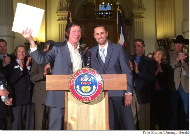
The Colorado Water Congress Wayne Aspinall “Water Leader of the Year” award goes to Bill Trampe

This year’s winner is Bill Trampe. Here’s the bio from the Colorado River District:
“I’m looking out and see a whole lot of people who deserve it more than I do…I hope I can live up to it.” — Bill Trampe
Bill Trampe represents Gunnison County. He served as president of the Colorado River District Board in 2006 and 2007. Upon serving out his term limit, he was designated by the board in 2008 to continue key negotiator roles he had performed in the Black Canyon of the Gunnison reserved federal water rights case and the Colorado River Basin Proposal on water supply solutions.
Mr. Trampe is a lifelong cattle rancher who has coupled his everyday experiences in water with involvement in water organizations. Mr. Trampe has a strong interest in natural resource issues, quality of life issues and the sustainability of communities whose economies depend on water.
Mr. Trampe was a founding member of the Gunnison Ranchland Conservation Legacy and served on the Upper Gunnison River Water Conservancy District Board.
Mr. Trampe is participating in the state’s Water for the 21st Century (HB1177) process, sitting on the Gunnison River Basin Roundtable.
Mr. Trampe’s current term expires January 2015.
In 2012 Mr. Trampe authored the paper “Risk Assessment Scenario for Portfolio Tool” to accompany the Gunnison Basin Roundtable’s formal comments on “Colorado’s Water Supply Future Portfolio and Trade-off Tool.” The planning tool examines different combinations of strategies or “portfolios” for meeting the state’s future municipal and industrial water needs. Mr. Trampe’s paper outlines the basic concepts the Gunnison Basin Roundtable members have concerning procedures or a process to employ risk management in order to avoid a Colorado River Compact curtailment.
Colorado Water Congress Annual Convention day 1 recap: “We have to be smarter” — @hickforco #CWC2015
From The Pueblo Chieftain (Chris Woodka):
Use less.
That two-word description is one way to boil down the Colorado Water Plan, all 2,000 pages and 15,000 comments on it, the Colorado Water Congress learned Thursday.
“We have to be smarter. We’re not going to have enough to do everything we want,” Gov. John Hickenlooper admitted in response to a question about how to provide water for 2-3 million more people in the state in the next 20 years with expected drop in water supply. “We are in a state that’s growing, and that growth has to figure out a way to use a lot less water.”
At the same time, the governor was brimming with optimism when it comes to solutions to the urban water gap.
Several times during his “State of the State’s Water” address to about 500 people at the CWC annual conference, Hickenlooper recognized water innovators by having them stand and take a bow. They included former lawmakers Russ George and Diane Hoppe; the Fort Morgan Irrigation Co., which developed water sharing agreements with Public Service Co.; Molson Coors, for its work since 1990 to improve the Clear Creek watershed; and innovators Chris Klein and Franz Garsombke, founders of Rachio, who developed a way to control sprinklers by smartphone. Those examples are just part of an approach that will be needed to deal with the water crises of the future, he said.
“In the next 20 years, we will add 2-3 million more people, and we’ve got to face that headon,” Hickenlooper said. “We know the climate is changing, regardless of the reason, so we always have to keep in mind the possibility of drought.”
He also stressed the importance of preserving agriculture.
“We’ve got to support locally grown food,” Hickenlooper said. “The water plan puts us on an actionable path.”
The governor deflected tougher questions about the state budget — water officials are concerned about siphoning mineral severance funds to balance it — to Henry Sobanet, the state’s budget director.
Sobanet called the constitutional formulas that control revenue and spending “insane” and said the state is facing a “nutrient sandwich” (to put in terms water people understand) as costs for education and health care continue to hog a bigger share of the budget pie.
A shortfall of $148 million in other areas would result this year without adjustment, and health and education shares are expected to grow, he said.
While the Colorado economy has been surging above the national rate since the 2008 recession, mineral severance taxes are expected to fall because of low oil and gas prices. At the same time, the funds used for water projects and local impacts may be swept into the general fund.
James Eklund, director of the Colorado Water Conservation Board, congratulated the group for helping develop the water plan.
“Many said the problem was too big to solve, but you saw its importance as too big to fail,” he said.
From The Denver Post (Bruce Finley):
The population growth in Colorado and other Western states cannot continue unless water supply challenges are met, Gov. John Hickenlooper and state planners said Thursday in opening the Colorado Water Congress annual conference.
“That growth has to figure out a way to use a lot less water or the growth will stop,” Hickenlooper told hundreds of water professionals in response to a question by a water board member. “It’s pretty much, I mean, black and white. We find a way to use a lot less water per person or we don’t have more people coming here. There is no magic.”
After beginning his State of the State address last week by highlighting water limits, Hickenlooper used the gathering of the 400-member congress to amplify his push for a robust and unprecedented Colorado Water Plan.
The state faces a 163 billion gallon projected water shortfall by 2050 that, as today’s population of 5.3 million grows to 10 million and industry expands, threatens to leave 2.5 million people parched. A draft plan unveiled in December lacks specifics such as conservation targets and criteria for new state-supported supply projects.
But the 344-page draft lists potential projects costing $18 billion to $20 billion to be done by 2050.
Hickenlooper said state planners are taking a long-range perspective that leads to a look at larger projects — but he said that financing major projects likely must rely on private investment because of state fiscal difficulties and diminished federal capacity to build new dams and reservoirs.
Constructing new water storage systems “helps a little bit,” Hickenlooper said. “But in the bigger picture, it is not the whole answer.”
Dealing with problems such as south Denver suburbs’ heavy dependence on dwindling groundwater will be addressed in the final state plan, due Dec. 10, said James Eklund, director of the Colorado Water Conservation Board, who has led creation of the plan. Eklund said the state may seek help from a Stanford University water expert pioneering measurement and monitoring of underground water — in shallow aquifers along rivers such as the South Platte and Arkansas as well as portions of the deep aquifers south suburbs have tapped.
Emerging water-sharing infrastructure projects may help shift south suburbs off dwindling groundwater, in return for assurances they do not try to divert more water from the deteriorating Colorado river basin.
“The more we can put the south metro house in order, the better the entire state is,” Eklund said. “It is kind of the knot you untie that alleviates pressure.”
Bee the difference: Sofía M. Villalpando (@sofiabiologista) #savethebees
Bee the difference #savethebees pic.twitter.com/UeHRHiJajv
— Sofía Villalpando (@sofiabiologista) January 30, 2015
Drought news: Northern Rockies and High Plains see temps up to 20 degrees above normal #drought

US Drought Monitor January 27, 2015

West Drought Monitor January 27, 2015

Colorado Drought Monitor January 27, 2015
Click here to go to the US Drought Monitor website. Here’s an excerpt:
Summary
Temperatures during the last week were well above normal over the majority of the United States, with departures of up to 20 degrees Fahrenheit above normal over the High Plains and northern Rocky Mountains. A few areas did experience temperatures below normal, mainly confined to west Texas and eastern New Mexico as well as southern New England, where departures were 5-10 degrees Fahrenheit below normal. At the end of the current Drought Monitor period, a strong winter storm impacted much of the northeastern United States with strong winds and snow. Most of the country was fairly dry over the last week with the southern plains, Gulf Coast, and southeast receiving the most precipitation. The western United States remained dry, and some areas are on track to having one of the driest Januarys on record…
The High Plains
As with the Midwest, warm and dry conditions dominated the region. Temperatures were 5-15 degrees Fahrenheit above normal for the week with very few places recording any precipitation. In response to short-term conditions, D1 was expanded north in North Dakota this week…
The West
Continuing the pattern for most of January, the week ended with warm and mainly dry conditions over the western United States. Temperatures were 5-10 degrees Fahrenheit above normal, and only portions of northwest Washington and eastern New Mexico recorded any precipitation of significance. With the ongoing drought, drought intensity did increase in portions of western Nevada as D4 conditions were expanded to the south and D3 conditions were expanded in the north. In eastern Nevada, D1 was introduced along the border with Utah. A large expansion of abnormally dry conditions was introduced from northeast Utah into Wyoming and western Colorado. In Oregon, the D1 conditions were expanded to the west along the Cascades while in Washington, D0 was expanded in the west and northern portions of the state as well as in northeast Washington into the Idaho panhandle. Some areas of central Washington did see enough precipitation to warrant improvement to D2 and D1 conditions.
The Colorado Water Congress Annual Convention gets started in earnest today

I’ll be live-tweeting the goings on today @coyotegulch.
Dam at Wolford Reservoir north of Kremmling moving slightly, but steadily — Aspen Journalism

Ritschard Dam movement graphic Colorado River District

Colorado River Basin in Colorado via the Colorado Geological Survey

Wolford Mountain Reservoir. An aerial view of Wolford Reservoir, formed by Ritschard Dam. The Colorado Water Plan outlines many different types of projects, including reservoirs and dams, that need funding.
From Aspen Journalism (Brent Gardner-Smith):
The Colorado River District board of directors was told last week it is time to address the consistent settling and movement occurring in Ritschard Dam, which holds back 66,000 acre-feet of water to form Wolford Mountain Reservoir, 5 miles upstream of Kremmling.
“The continued movement of the dam at Wolford Mountain Reservoir is the most important issue currently facing the River District,” states a Jan. 8 memo from John Currier, the chief engineer at the district.
Though the dam is far from being at risk of failure, if that happened at some point in the future with a full reservoir behind it, there is the potential for 600,000 cubic feet per second to run down Muddy Creek toward Kremmling, said Jim Pokrandt, communications manager for the district. Eighteen hours later, the massive surge of water would reach Glenwood Springs.
The board discussed the situation at the dam during a regular quarterly meeting in Glenwood Springs.
“We see this continued downward movement of about an inch a year, unabated, with no evidence that it is really going to slow down,” Currier told the River District board. “It is a significant concern and is something we need to address.”
Just 20 years old
The dam has an impermeable clay core that is covered on both the upstream and downstream sides with rock fill, including shale rock excavated on site during construction.
In 2008, engineers working for the river district noticed the dam had settled downward by a foot-and-a-half, instead of the expected normal settling of one foot.
They decided to install monitoring equipment, including inclinometers, which measure slope angles.
Engineers for the river district have since installed an increasingly sophisticated array of monitoring devices. And they’ve verified that the dam has now settled over 2 feet downward.
The dam has also moved horizontally, by 8 inches, at a location about 40 to 50 feet from the top of the dam.
Mike May, an engineer with AECOM, told the river district board that because of “poorly compacted rock fill,” the dam’s rocky outer shells are still moving, especially the downstream shell, and that the clay core of the dam, which is somewhat elastic, is also moving.
While the dam does not have “a global stability problem,” May said the concern is that if enough movement occurs, it could cause cracks in the clay core.
Water could then find its way into those cracks and start transporting material and widening the cracks, and then the dam could eventually be at risk of failing.
“If we lose the integrity of that core, at that point the threat we’re under is essentially having the dam completely fail,” Dan Birch, the deputy general manager of the river district, told his board of directors.
“And the scenario that happens when the dam fails is a lot worse than any flood that Mother Nature could create, and we’re talking just tremendous amounts of devastation and tremendous potential for loss of life,” Birch said.
“It is a very serious situation (that) as an organization we are, have been, and will continue to take very seriously,” Birch said.
State dam expert briefed
Bill McCormick, the chief of dam safety for the state of Colorado, was briefed on the dam’s situation on Jan. 14.
“Everyone involved (including the downstream public and the emergency management community) are now more aware of the dam’s operation than they ever have been before,” McCormick said via email on Jan. 22.
“The extensive investigations and analysis to date show that the dam remains strong and stable but that if left unabated, the movements could ultimately (in decades) create greater damage to the dam structure,” McCormick said. “The safety of the dam is being managed through the river district’s changes in normal operations, which include maintaining a reduced reservoir level and increased surveillance including real-time monitoring.”
The dam was last inspected by the state in November, and there are no restrictions yet in place from the state that would force the river district to lower the water level in the reservoir. The district did, however, voluntarily lower the water level by 10 feet in 2014 to take pressure off the dam.
Dick Davidson, a senior engineer and dam expert with AECOM, told the River Board it was his professional opinion that it was time to move toward a solution.
“We are not in an emergency, by any stretch, but we have definitely stressed our core beyond where we like it to be,” Davidson said. “So let’s figure out what we need to do. Let’s look at our options.”
One option is to spend up to $30 million rebuilding the dam.
Another potential option is to store significantly less water in Wolford Reservoir, which is about two-thirds the size of Ruedi Reservoir, in order to take pressure off the dam. However, that may buy the river district some time but not solve the problem.
A refined set of options is now expected to be brought back to the river district board at both its April and July board meetings.
Editor’s note: Aspen Journalism is collaborating with The Aspen Times and the Glenwood Springs Post Independent on coverage of rivers and water. The Post published this story on Wednesday, Jan. 28, 2015.
More Colorado River Basin coverage here.
River district frets over flawed dam above Kremmling — Glenwood Springs Post Independent #ColoradoRiver

From the CWC Storytelling workshop.
From the Glenwood Springs Post Independent:
The Colorado River District board of directors was told last week it is time to address the steady settling and movement occurring in Ritschard Dam, which holds back 66,000 acre-feet of water to form Wolford Mountain Reservoir, 5 miles upstream of Kremmling.
“The continued movement of the dam at Wolford Mountain Reservoir is the most important issue currently facing the River District,” states a Jan. 8 memo from John Currier, the chief engineer at the district.
More Colorado River Basin coverage here.
Colorado Water Congress Annual Convention — Once Upon a Time: Telling our Water Stories

John and Mrs. Gulch in Coyote Gulch May 2000

Lowering backpack at Crack-In-The-Wall

Stevens Arch viewed from Coyote Gulch photo via Joe Ruffert

Lower Coyote Gulch

Coyote (Canis Latrans) silhouette howling at sunrise via Michael Francis Photography
If you are attending today’s workshops stop by “Once Upon a Time: Telling our Water Stories”. I’ll be on hand to tell you everything you need to know about starting a blog like Coyote Gulch. Here’s the blurb from CWC:
As we will learn more about during our keynote talk at Thursday’s lunch, the public is very interested in water. When Colorado’s population searches for the facts, the water community will be their best source of information. We need to be prepared to share our stories and celebrate our successes. Join us as we learn how to make engaging stories about water in oral, visual, and written formats.
Snowpack news: “You are rightfully feeling a sense of uneasiness when the temperature starts shooting up to 70 degrees in January” — Nolan Doesken
From KUNC (Stephanie Paige Ogburn):
According to state climatologist Nolan Doesken, most basins are sitting right around average.
“No part of the state is desperately below average, no part of the state is above average,” he said. The Colorado River headwaters are at about average. “Those with the lowest snowpack are the Yampa-White, in the northwestern part of the state, and the Rio Grande, in the south.”
This is true even despite record-breaking warmth hitting parts of the state in the past two days; Fort Collins shattered its temperature record for the month of January, hitting 75 degrees on January 26.
‘You are rightfully feeling a sense of uneasiness when the temperature starts shooting up to 70 degrees in January, that happens hardly ever, but so far — so far, we’re OK,” said Doesken.
In fact, the warmth may signal an early transition to the spring season, when Colorado often gets pounded by snowstorms.
“Not getting many storms is sort of common for midwinter, but then…when you flip the switch from midwinter to spring as imminent, then we become distinctly more favored again to be in the path of some of these storms.”
Doesken also noted that current weather patterns look a lot like an El Niño. That usually means the southern part of the state will get more moisture coming across from California.
From the Fort Collins Coloradoan (Adrian D. Garcia):
Fort Collins temperatures have plummeted to minus-5 and soared to 75 degrees in January alone. But the most significant changes of the season likely lie ahead, according to weather experts at the Colorado Climate Center in Fort Collins.
“Expect to see more dramatic weather before February, March and April pass,” State Climatologist Nolan Doesken said Tuesday. It’s not uncommon for temperatures to sharply rise or fall during autumn, winter and spring along the Front Range…
“Temperatures have not been abnormal for this time of year,” Doesken said. “What was abnormal was how warm it got yesterday (Monday) when we had the warmest day in January on record.”
Temperatures reached 75 degrees Monday, according to readings from Colorado State University’s Fort Collins weather station. The previous record for the month was 73 degrees, set in 1996. Tuesday set another record for the day with an official high of 72 degrees, breaking the record of 65 degrees set in 1987.
Average temperature for this time of year is the mid-40s…
It’s all a part of the continuum in the jet stream,” Doesken said.
Put more simply, cold air made its way from the Pacific Ocean up to the Canadian Rockies and then curved back south over the Midwest before turning sharply toward the East Coast with the result of snow and freezing temperatures. Boston was expected to receive nearly 2 feet of snow.
Colorado was right on the edge of that wind pattern, leaving warm air in the West and pushing cold air on, Doesken said.
Even without recent snow, Northern Colorado’s snowpack is looking only slightly below average.
“For us, a large fraction of our moisture comes, or fails to come, in the March-April-May period,” Doesken said. “We have a lot of time to catch up and accelerate or fall behind. There’s a whole lot more to this winter we haven’t seen yet.”
Want more on snowpack? Listen to "Snow Job" about how surveyors figure out how much #water will come out of your tap> http://t.co/P4nWz6ATnl
— H2O Radio (@H2OTracker) January 28, 2015
See Rocky Mountain National Park through the lens of Denver Post photographer Joe Amon
See @RockyNPS through the lens of @denverpost photographer Joe Amon in honor of their 100th http://t.co/A56VSt5OOY pic.twitter.com/lZTWxF6gKf
— National Park Service (@NatlParkService) January 26, 2015
The City of Aspen councilors decide to let FERC hydropower application expire in March

Aspen

Micro-hydroelectric plant
From The Aspen Times (Karl Herchenroeder):
The Federal Energy Regulatory Commission granted Aspen its first three-year preliminary permit for a 1,175-kilowatt hydropower plant on lower Castle Creek in November 2008 and a second three-year permit in March 2012.
City Attorney Jim True recommended allowing the permit to expire on March 1, which would officially put the controversial Castle Creek Energy Center on ice, for now. City officials did, however, agree to continue exploring micro-hydro projects on Castle and Maroon creeks, which True said would involve protection of city water rights.
“We will update you on those issues,” True told the council, adding that there will be more detailed analysis later. “We do believe there are additional protections.”
Will Dolan, the city’s utilities project coordinator, said that if the city were able to install low-head hydro on Maroon Creek, it would allow it to run more water through the existing Maroon Creek hydroplant and “optimize production.” Councilwoman Ann Mullins asked if it will affect streamflows.
“It wouldn’t affect the flow regimes necessarily,” Dolan said. “It would allow us to more fully utilize our water rights, but it wouldn’t create any additional diversion from the stream.”
“These are issues we want to bring back in greater detail,” True said, adding that consultation with federal and city water attorneys is needed.
Councilman Adam Frisch said he believes there is broad community support to explore micro-hydro and called the plan that True laid out “a great step forward.” None of the council members offered objections to True’s recommendation.
“I agree to let it expire, continue the investigation of micro-hydro and have a universal statement on protecting water rights,” Councilman Dwayne Romero said.
In March, the city filed a progress report saying it was still working on the Castle Creek project, despite a November 2012 advisory vote where 51 percent of city voters said the city should stop doing so.
However, in June, the city settled a lawsuit over its water rights for the proposed hydroplant. Both the settlement and a subsequent city council resolution said the city “will not be pursuing or seeking to complete the Castle Creek Energy Center hydroelectric project at this time.”
CWCB approves Caitlin Canal lease to Fowler, Security, and Fountain for augmentation and exchange

Straight line diagram of the Lower Arkansas Valley ditches via Headwaters Magazine

Arkansas River Basin — Graphic via the Colorado Geological Survey
From The Pueblo Chieftain (Chris Woodka):
A plan to lease water from the Catlin Canal to Fowler, Fountain and Security beginning this year got final approval this week from the Colorado Water Conservation Board.
“This is truly beneficial to our basin and the state,” said Alan Hamel, who represents the Arkansas River basin on the CWCB. “I have a sense of urgency about seeing this happen, so that farmers will not give up on the idea of the Super Ditch.”
The plan comes with 60 conditions, 59 from State Engineer Dick Wolfe, who sorted through objections from other water users prior to recommending approval last week, and another added Monday dealing with precedence.
No one spoke against the proposal and approval was unanimous.
The application, under the umbrella of the Arkansas Valley Super Ditch and Lower Arkansas Valley Water Conservancy District, is the first approved as a pilot project under 2013 legislation, HB1248.
During a 10-year period, up to 500 acre-feet annually (162 million gallons) will be made available to the cities. About half will serve as replacement water for wells in nearby Fowler under current plans. The remainder will be transferred by exchange to Lake Pueblo, where it can be physically piped to El Paso County through the Fountain Valley Conduit.
Wolfe spelled out that the use of the shares is a temporary change and that using the water would have no impact on the Arkansas River Compact with Kansas. All other water rules, including Pueblo’s flow maintenance programs, must be observed. While 1,100 acres are involved, only 311 Catlin shares on six farms will be used to provide the water. The exhaustive list of conditions specifies that water from any given farm is available only three out of every 10 years and only 30 percent of a farm may be dried up at any given time.
Daily, periodic and annual accounting is required, and recharge ponds will be used to assure return flows that normally would have come from irrigation to replace water to the river system at the right time and place.
“It’s important that we move forward, because the biggest part of the municipal gap in the Arkansas basin is in El Paso County,” Hamel said.
At the last roundtable meeting, a proposal by the Pikes Peak Regional Water Authority underscored concerns that more farmland could be dried up if alternatives such as Super Ditch are not explored, he added.
Hamel also is open to more long-term arrangements that would tie conservation easements to water leases, so cities would have more certainty of future supply, while the primary use of water would remain in agriculture.
More Arkansas River Basin coverage here.
Popular Mechanics: Astronomers have discovered the oldest known rocky planets, and they’re twice Earth’s age
Astronomers have discovered the oldest known rocky planets, and they're twice Earth's age http://t.co/006sFjfEd4 pic.twitter.com/XiOAIbZmXd
— Popular Mechanics (@PopMech) January 28, 2015
January 28: Common Sense Solutions for the Colorado River — Drew Beckwith #ColoradoRiver

From the Western Rivers Action Network:
With so much happening at the state and local levels with our Western Rivers work, you may be wondering what is happening with our rivers at the federal level. Some of you got a bit of teaser on that subject on last week’s webinar with our Arizona team and Brian Moore, Audubon’s Legislative Director who is keeping an eye on policy movements on rivers in DC. But for the rest of you, we will do another policy update webinar soon and include more of a federal component for the entire Colorado River Basin. Stay tuned for more information on that webinar. Also look for opportunities emerging soon for all of you to add your voices of support for federal funding programs that will aim to protect the Colorado and other important western rivers. And certainly there will be some proposals in Congress that we are tracking closely aimed at protecting—or in some instances harming—our precious rivers and water resources. We will be sure to give you every opportunity we can to weigh in on those measures as they become available for comment.
Mark your calendars Our webinar series continues this Wednesday, January 28 from noon to 1pm MST with Common Sense Solutions for the Colorado River presented by Drew Beckwith of Western Resource Advocates and our own Abby Burk of Audubon Rockies. This webinar will be valuable for anyone interested in hearing about what you can do to help protect the Colorado River. Whether you live in Colorado, New Mexico, Arizona or elsewhere, you will get lots of great information from this engaging presentation. Advance registration is required.
More Colorado River Basin coverage here.
Here’s What Every Governor Thinks About Climate And Clean Energy — Climate Progress
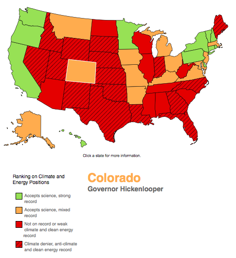
Click through for the interactive map of governor’s views by state. Here’s an excerpt from Climate Progress (Ryan Koronowski):
The new Republican majorities in the 114th Congress are mostly — 56 percent — on the record denying the reality of climate change. And barely two weeks into its tenure, the 114th is on a roll, with the new Senate Environment Committee Chair going on a rant about climate change being a hoax the first day he got his gavel, and a series of odd amendment votes on a bill approving the Keystone XL pipeline revealing that the Senate itself may be a hoax.
What about the leaders of each of the 50 states, unburdened by congressional backbiting, national lobbying, or being whipped by party leaders? Working closer to the various impacts of climate change, do governors fare any better on either acknowledging humans cause climate change or working to do something about it?
COLORADO
Governor John Hickenlooper (D)Colorado Governor Hickenlooper has said humans are contributing significantly to climate change and that to reverse it will take “a concerted effort, not just on the part of the United States, but worldwide.” Hickenlooper spearheaded efforts and signed into law first-of-their-kind limits on methane — a potent climate pollutant — from oil and gas production. As a former petroleum geologist, he’s been a big supporter of the oil and gas industry in Colorado. He appointed an industry campaign donor to oversee the oil industry. In 2012, he appeared in paid advertising supporting the Colorado Oil and Gas Association, an industry lobby and trade group which has a history of fighting health and safety standards. He has even drank fracking fluid to prove there was no risk to human health. More recently, he compromised an 11th-hour deal to keep contentious oil and gas measures off the November 2014 election ballot. Hickenlooper has also developed a troubling record of opposing protections for at-risk wildlife in oil and gas producing areas, including the lesser prairie chicken, the Gunnison sage grouse, and the Greater sage grouse. Despite his close ties with the fossil fuel industry, Hickenlooper has been a proponent of renewable electricity, and signed a bill that doubled the renewable power target for rural electric cooperatives. Governor Hickenlooper won re-election in 2014 and this will be his last term.
CWCB Drought update #drought

Snow water equivalent forecast April 1, 2015 via Klaus Wolter

Colorado average temperature 1895 thru 2015 via the Colorado Climate Center

Colorado average precipitation 1895 thru 2014 via the Colorado Climate Center

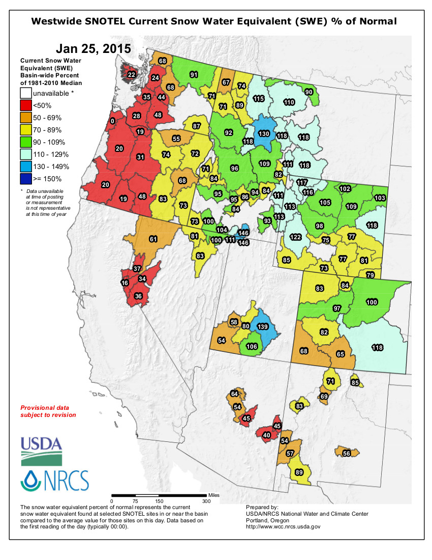
Statewide snowpack as a percent of average January 23, 2015

US Drought Monitor January 20, 2015
Click here to go to the Colorado Water Conservation Board Water Availability and Flood Task Forces website. From email from the Colorado Water Conservation Board:
Globally, calendar year 2014 was the warmest on record. In Colorado the year ended with above average temperatures, making it the state’s 18th warmest calendar year and the warmest since 2012. Following a wet month of precipitation in December, January 1st snow accumulation was above average for the northern half of the state. 2014 was the wettest calendar year in Colorado in 15 years. However, temperatures and precipitation have been warm and dry this month, with many basins receiving less than 50% of average January precipitation, and short term forecasts do not indicate any major storms in the last week of the month. Along the Front Range, water providers continue to indicate that storage levels are at, or near, record levels.
Year-to-date precipitation at mountain SNOTEL sites, as of January 20, was 87% of normal statewide. The South Platte basin has the highest snowpack at 103% of normal, while the Upper Rio Grande basin had the lowest at 64% of normal. We have reached the mid-way point towards peak snowpack in most basins, so it will be increasingly harder to make up for the biggest deficits. Reservoir Storage statewide is at 105% of average as of January 1st. The lowest reservoir storage statewide continues to be the Upper Rio Grande, with 67% of average storage. The South Platte has the highest storage level at 124% of average. Reservoir Storage in the Upper Rio Grande has been below normal for most of the last 14years. South Platte Reservoir storage levels are at the highest levels in Natural Resource Conservation Service records; and Northern Water is reporting that Carter Lake, Lake Granby and Horsetooth Reservoir have the highest combined levels in the history of the project. January 1st streamflow forecasts are near normal for most of the northern half of the state and below normal for the basins in the southwest and Rio Grande. However, the lack of precipitation in January will likely result in decreased forecasts for February 1st statewide. The Surface Water Supply Index (SWSI) for the state is near normal across much of the state. The lowest value in the state reflects low reservoir levels in Platoro reservoir. Both the Climate Prediction Center and the Long-term Experimental forecast predict above average precipitation for the next three months. However, this year has been unique and there are no good analog years that can provide insight on how reliable these forecasts are.
University of Colorado: 2015 Martz Winter Symposium, February 12-13

Click here for the inside skinny and to register. Here’s an excerpt:
Many believe that global institutions and frameworks are failing to generate necessary progress on issues such as climate change, water scarcity, biodiversity, food security and nutrition, and poverty eradication; and that state, tribal, and local governments and communities, innovative companies, social and technology entrepreneurs, NGOs, impact investors, consumers and philanthropists increasingly are taking the lead in creating bottom-up solutions to these challenges.
The conference will explore this dynamic in detail, with an emphasis on the drivers behind these ground level innovations, and on how they can better “filter up” to inform the global conversations occurring on how best to address various dimensions of “global change”.
CPW: Elkhead Reservoir and native fish to be discussed at open house in Craig

Elkhead Reservoir back in the day.

Upper Colorado River Endangered Fish Recovery Program

Yampa/White/Green/North Platte river basins via the Colorado Geological Survey
Here’s the release from Colorado Parks and Wildlife:
Residents of Craig and the surrounding areas will have the opportunity to discuss the Upper Colorado River Endangered Fish Recovery Program and Elkhead Reservoir fish management with several key partners during an open house, Thursday, Feb. 5, beginning at 6 p.m. at Craig City Hall, 300 West 4th Street.
The open house format will allow program representatives to answer questions and provide information about the multi-faceted program and its goals of protecting four endangered native fish – the Colorado pikeminnow, humpback chub, bonytail and razorback sucker – found only in the Upper Colorado River Basin.
“People who attend will learn what they can do to help us achieve what we all want, that is to bring this recovery effort to a successful conclusion,” said Senior Aquatic Biologist Sherman Hebein of Colorado Parks and Wildlife. “We understand that people have questions and concerns, so we welcome this opportunity.”
Among the various topics up for discussion will be how Elkhead Reservoir’s predominantly non-native fishery affects local native fish populations, and actions that Recovery Program partners are taking to manage non-native fish populations in the Yampa River and throughout the upper Colorado River basin.
According to principal investigators working on native fish recovery, escapement of non-native fish such as northern pike and smallmouth bass, found in significant numbers in Elkhead Reservoir and several other waters in Western Colorado, are among the primary obstacles to the full recovery of the endangered fish.
“Non-native fish often escape from reservoirs, ponds and other bodies of water into rivers where they not only compete with natives for available habitat, they also eat them,” said Hebein. “Based on years of data analysis, we have determined that non-native predators are the main reason we have yet to fully recover our native fish populations. It’s a major problem that we can overcome, but it will take significant effort from the partners and cooperation from the public.”
Recent reports that the reservoir might be drained and chemically reclaimed to remove the non-natives led to much discussion and concern in the community; however, at a joint workshop with Moffat County Commissioners and the Craig City Council last December, Hebein announced that CPW and its partners are implementing the installation of a net across the reservoir’s spillway to reduce the number of northern pike and smallmouth bass that escape into the Yampa River. Netting the spillway would provide time to implement other non-chemical management actions to reduce the numbers of smallmouth bass and northern pike in the reservoir.
“We anticipate that there will be many questions about the net and Elkhead’s future,” said Hebein. “We look forward to the opportunity to explain the complexities of the issue to the public.”
Hebein says that the public will have the opportunity to provide both written and verbal comments during the meeting.
For more information about the Upper Colorado River Endangered Fish Recovery Program, visit http://www.coloradoriverrecovery.org/
More endangered/threatened species coverage here.
Snowpack news: Southern basins struggling, help on the way this weekend

Statewide snowpack as a percent of average January 23, 2015

Arkansas River Basin High/Low graph January 23, 2015 via the NRCS

Upper Colorado River Basin High/Low graph January 23, 2015 via the NRCS

Gunnison River Basin High/Low graph January 23, 2015 via the NRCS

Laramie and North Platte Basin High/Low graph January 23, 2015 via the NRCS

Upper Rio Grande Basin High/Low graph January 23, 2015 via the NRCS

San Miguel, Dolores, Animas, and San Juan Basin High/Low graph January 23, 2015 via the NRCS

South Platte Basin High/Low graph January 23, 2015 via the NRCS

Yampa and White Basin High/Low graph January 23, 2015 via the NRCS
https://twitter.com/martyconiglio/status/559703366121447424
From CBS Denver (Chris Spears):
The latest numbers for statewide snowpack show northwest and southwest Colorado are running behind where they should be for this time of year.
Some of the driest conditions can be found in the Upper Rio Grande and the San Juan-Dolores-San Miguel-Animas River Basins.
The South Platte River Basin, which includes Denver and much of the Interstate 25 Urban Corridor is doing the best at 103 percent of median.
You might notice I said median instead of average.
Even though the two terms are often used synonymously, there is a difference.
A median ranks data from largest to smallest and then picks the value in the middle, leaving an equal number of points on either side and helping to keep the data from being skewed.
An average can be used, but it might be significantly influenced by a few values if they are clustered at either end of the range.
Therefore, when it comes to talking about snowpack, the Natural Resources Conservation Service has set a standard to use the median versus the average.
While you might be inclined to look at these numbers and feel discouraged, especially if you live in one of the basins that are running behind, don’t be.
There is still plenty of time left in the snow accumulation season to make a difference.
And the most recent outlook from NOAA’s Climate Prediction Center is calling for a wetter-than-normal end to winter and start of spring.
I always think back to 2003 when I look at numbers like we have now on the statewide snowpack.
One good slow-moving, soggy storm can change the outlook dramatically, as it did that March.
"Where is the #SNOW? Isn't it #WINTER?" Answer: it's due to the #REXBLOCK! See image for more info. #cowx #utwx pic.twitter.com/OsdmIvvf9r
— NWS Grand Junction (@NWSGJT) January 25, 2015
Climate study predicts doubling of extreme La Niñas
Snowpack news: Colorado snowpack dropping as a percent of normal
You can count on some melting this week as sunny days dominate and temperatures are above average.
From The Aspen Times (Scott Condon):
Last year wasn’t the hottest on record for Aspen, according to daily maximum and minimum temperature data stretching back to 1940, but data shows a definitive long-term trend toward significant warming, according to Jaime Cundiff, forest program director for the Aspen Center for Environmental Studies.
The number of annual frost-free days has soared since the 1950s and the number of consecutive frost-free days also is trending higher, Cundiff said. Snowpack levels vary from year to year with no definitive trend, but evidence shows that the snowpack is melting out sooner in the spring, she said. And the number of winter days with temperatures at or below zero is falling, creating more mild winters.
All of those factors have consequences for the environment, Cundiff said. Frost-free days, for example, can affect the budburst of vegetation and the overall species composition of an area.
ACES is analyzing weather and snowpack data for Aspen, among other mounds of data, as part of its Forest Health Index — an ongoing project to monitor a wide range of interlocking environmental conditions that affect forest health.
As part of the study, ACES found that the number of frost-free days in Aspen increased from an average of 73 per year in the 1950s to 99 in the 1990s and 107 in the 2000s.
Aspen also is experiencing milder winters. In the 1940s, there was an average of 35 days per year at or below 0 degrees during the 1940s. That fell to an average of 15 days per year during the 2000s.
“Extreme low temperatures are understood to play an important role in forest ecology,” the Forest Health Index said. “For instance, hard freezes are believed to help control insect-related disturbances such as the Mountain Pine Beetle infestation. Changes in extreme cold also serve as a broader indicator of change to the region’s climate.”
The index also found, in general, that the Aspen-area snowpack starts melting a week earlier in the spring and reaches the half-way melt-out period about one week sooner in the summer than it did in earlier decades.
A second report, Climate Change and Aspen, prepared by the Aspen Global Change Institute for the city of Aspen, noted many of the same environmental trends.
“For Aspen, climate change will likely include longer summertime warm periods, earlier onset of spring snowmelt, more precipitation arriving as rain rather than snow, and longer dry periods with heavier precipitation events in between,” said the report, released in December. “These types of changes could exacerbate already risky wildfire conditions, place extra pressure on already stretched water providers and users, provide additional challenges to ski area operators and other winter and summer recreation providers, as well as result in other impacts to every sector important to the Aspen community.”
Cundiff said the Forest Health Index places more stock in extremes, such as number of days with high and low temperatures rather than average annual temperatures. Statistics for any given year aren’t really useful. It’s trends that the index is seeking.
Nevertheless, she analyzed maximum and minimum daily temperatures for Aspen since 1940 and found that the average annual temperature between 1940 and 2014 was 41.44 degrees. The average for 2014 alone was 42.71 degrees. However, 2014 didn’t stand out. Several other years were at or above that temperature, she said. So, climate change didn’t make 2014 the hottest on record for Aspen, but trends show global warming is stressing Aspen’s environment.
EPA’s McCarthy will make a number of appearances in Aspen today. She will speak to an Aspen Middle School class, visit the Winter X Games, meet for lunch with Aspen Skiing Co. officials and give a press conference — all designed to build support for regulations the EPA is drafting to battle climate change.
Palmer Lake: “If we could all get together and try to figure this out without getting attorneys involved, I’m all for it” — Rafael Dominguez

Monument Lake

Palmer Lake via Wikipedia Commons

Fountain Creek Watershed
From The Colorado Springs Gazette (Ryan Maye Handy):
The towns of Palmer Lake and Monument are in a gridlock over 21.8 million gallons of water, a bitter debate that could pit the towns against each other in court.
Palmer Lake residents, desperate to use the water to save their dry lake, thronged Monument’s Tuesday evening board of trustees meeting to plead for water.
Palmer Lake has been grappling with the state and other southern Colorado water districts since December 2013, when it asked to convert an old railroad water right into something that could save the lake.
The railroad water right has gone unused since the late 1950s, when Colorado’s railroads stopped running steam engines.
For the Town of Monument, losing 67 acre feet of water – an acre foot of water is enough to cover a football field in a foot of water – could have a serious impact on Monument Lake. The towns are working on a negotiation, but without a settlement their dispute will be take to court on Feb. 3.
Monument carefully monitors the lake, and even when it is down 1/100th, town administrators know, said Tom Tharnish, director of public works. Sixty-seven acre feet, or 21.8 million gallons a year, is about a month’s worth of drinking water for Monument.
“If you take 67 acre feet, there’s going to be an effect on Monument Lake,” he said.
While others have steadily dropped from the case, Monument has remained staunch about protecting the town’s water. But Tuesday’s meeting brought together residents from both towns, many of whom pleaded with the board of trustees to let Palmer Lake take the water.
Most argued that the towns are one community and should be invested in each other’s prosperity. Jodie Bliss, a Monument business owner, was one of a few Monument residents who spoke in favor of using the water right to fill the lake.
“I support filling Palmer Lake,” she told the trustees. “My point of view has to a lot to do with the fact that we are one community.”
Residents like Bliss packed the town hall and filled the parking lot. One man in the audience spoke out against Monument turning the water rights over to Palmer Lake. Other audience members joked that the famed “tri-lakes region” has only two lakes.
Jeff Hulsmann of Awake Palmer Lake, a group founded to help resuscitate the lake, was the last to speak on Tuesday. He echoed earlier pleas to encourage cooperation between the two closely connected towns.
“It’s incredible to me how many people came up here and said, ‘Well, I live in Palmer Lake but I used to live in Monument’,” he said. “I implore you, do something that works for all of us.”
From The Colorado Springs Gazette (Ryan Maye Handy):
When Palmer Lake resident Cynthia Graff took her seat in front of the Monument board of trustees last week, she was one in a long line of area residents who came to plead for a timeless Western right – water.
Water, specifically in Palmer Lake, is part of what drew Graff and others to the Tri-Lakes region. Even after development cut off the flow of runoff into the natural lake, Palmer Lake residents have fought for six decades to keep the iconic lake full. But now the town is fighting for the water against close competitors, the town of Monument and its lake, pitting the survival of one lake against another.
For some locals, the fight over an old railroad water right has one resolution – to fill Palmer Lake, which has been dry since 2012 and began losing water a decade ago.
“We just think this is our water,” Graff said at Tuesday’s meeting. “We deserve to have it back in our lake so we can deserve to be the Tri-Lakes area again.”
Although the meeting was thronged with Monument business owners, Palmer Lake residents and combinations of both advocating to fill the lake, the towns’ lawyers have yet to agree on the fate of 21.8 million gallons of water.
Palmer Lake has been unofficially tapping into the water, once used to fill steam engines on the Denver & Rio Grande Railroad, since the engines were pulled from the tracks in the late 1950s. But when the town filed in December 2013 to make that water use official, it met with state and local resistance – common in a state where water rights have always been carefully protected.
The town asked for 67 acre feet of water to fill the lake each year – an acre foot is enough to cover a football field in a foot of water.
One by one, objectors to Palmer Lake’s plan to fill the lake settled with the town, all except Monument. Using the water to fill Palmer Lake would lower levels in Monument Lake, which has been declining because of evaporation, said Tom Tharnish, Monument’s director of public works.
“If you take 67 acre feet, there’s going to be an effect on Monument Lake,” Tharnish said.
Unless the towns can settle on the fate of the water, the fight is headed to court Feb. 3. Jeff Hulsmann of Awake Palmer Lake, a nonprofit created to help restore the lake, believes the town stands a good chance to secure the water it needs.
“We have an awful lot of confidence that we will win in court,” he said.
Hulsmann has a complicated relationship with both towns – as do many people who live in one town but own a business in the other. Hulsmann knows that ultimately helping Palmer Lake could mean harming Monument Lake.
“I lose on both ends of this deal,” he said.
A rare body of water
As legend has it, when General William Jackson Palmer scouted southern Colorado for railroad routes, he believed Palmer Lake – the only natural lake for miles around – to be truly unique.
“He apparently said, ‘It was the only open body of water between Denver and El Paso, Texas,'” said Tom VanWormer, of the Palmer Lake Historical Society.
Palmer Lake became an essential part of southern Colorado life, supporting a resort town and providing water for steam engines and ice for refrigeration. Palmer wasn’t the first to discover it, however – Ute Indians lived nearby long before William Finley Thompson plotted the area in the 1880s and christened “Loch Katrine.”
Although Palmer eventually gave his name to the lake, it remained a contested source of water and recreational spot for railroads passing through, VanWormer said. Palmer’s Denver & Rio Grande railway later competed with the Atchison, Topeka and Santa Fe Railway for use of the lake’s water and shores.
“It was a great place to come and picnic, to row boats around,” VanWormer said. But to keep the rival railroad’s passengers from venturing to the lake, Palmer had an “8-foot tall barbed wire fence” built on the AT&SF side, VanWormer said.
Later, reservoirs and dams would add Monument and Woodmoor lakes – giving the Tri-Lakes region its name. None of lakes were used for drinking water. Instead, the towns relied on reservoirs and wells to put water in their taps and used creeks to fill their lakes. But when railroads retired steam engines, water in the Tri-Lakes area took on a new significance – supporting increasing populations and keeping the lakes, diminished without runoff, full.
‘It’s an emotional issue’
Thanks to a lease from the railroad, Palmer Lake had tacitly used the old railroad water right to fill its lake for half a century. But in 2002, a severe drought year, publicity about the lake’s ability to stay full brought scrutiny to that agreement, Hulsmann said.
“In 2002, the state comes down and says, ‘Hey, what are you guys doing?'” Hulsmann recalled. “So essentially the state says you can’t use the water right (because) it’s an industrial water right.” [ed. emphasis mine]
Palmer Lake purchased the leased water right in the 1980s, but in state records, the right was still marked for industrial use. According to Colorado’s water laws, it could not be used to fill the town’s lake. In December 2013, Palmer Lake filed to have the right declared a municipal one, fair game for lake-filling. But nothing is that simple in water court.
“So basically everybody downstream objects, and we expected that. If you don’t object then you get no information,” Hulsmann said.
To prove its right to use some of the water abandoned by the railroad, Palmer Lake hired expert witnesses to delve into decades of data on the railroad’s water use. Calculating the number of engines that passed by the lake per day between 1871 and 1955 – 20 to 30 – and factoring in tank size, the study determined that Palmer Lake could use 112 acre feet a year to fill the lake. The town settled for 67 acre feet, Hulsmann said.
The objectors – among them the Colorado Water Conservation Board and the city of Colorado Springs – eventually settled with Palmer Lake, but the town of Monument remained the sole objector, claiming that Palmer Lake abandoned the water and had no right to champion for its official use to fill the lake. Monument officials believe that Palmer Lake has yet to exhaust all ways to get water – for instance digging wells or purchasing another water right. Nonetheless, administrators from both towns say an agreement is in the works.
“There are still negotiations going on,” said Gary Shupp, the lawyer for the town of Monument. “Whether this case goes to trial or not still remains to be seen.”
Palmer’s days of railroad wars are long over, but the subject of water clearly remains a deeply personal one when it comes to Palmer Lake’s survival. At Tuesday’s trustees meeting, residents claimed all chairs and standing room. All but one person spoke up and asked the board to drop Monument’s objection to Palmer Lake’s water use request. Ultimately, Monument Mayor Rafael Dominguez had the last word.
“If we could all get together and try to figure this out without getting attorneys involved, I’m all for it,” he said. “We don’t want to harm Palmer Lake at all. But it’s a water rights issue. And water rights are a big issue in the state of Colorado.”
The residents absorbed his comments and then, one by one, got up and left the room.
More water law coverage here.
Higher streamflow, groundwater Subdistrict No. 1 curtailments, boost unconfined aquifer by 71,440 acre-feet in 2014
From The Pueblo Chieftain (Matt Hildner):
Irrigators and water officials looking to conserve groundwater in the San Luis Valley got a small dose of good news this week. The volume in the unconfined aquifer — the shallower of the valley’s two major groundwater bodies — increased by 71,440 acre-feet in 2014.
“We did turn the corner,” said Allen Davey, an engineer who conducts the Rio Grande Water Conservation District’s groundwater monitoring.
The increase was the first since 2009.
Davey attributed the hike to better stream flows than had been seen in recent years.
He also pointed to a decline in pumping in Subdistrict No. 1, which has used a combination of fees on pumping and the fallowing of farm ground to reduce demand on the aquifer in the north-central part of the valley.
The unconfined aquifer has traditionally been used by farmers in the valley to water crops like potatoes, barley and alfalfa when the availability of surface water declines in mid- to late-summer.
Recharge to the shallow aquifer occurs from streams entering the San Luis Valley floor, canal leakage and irrigation return flows.
Despite this year’s slight improvement, the unconfined aquifer has declined by more than 1.2 million acre-feet since monitoring began in 1976.
An acre-foot is the equivalent of roughly 325,000 gallons of water.
The long-term decline is of concern to the managers of Subdistrict No. 1, who have the goal of increasing the volume of the unconfined aquifer by 800,000 to 1 million acre-feet.
David Robbins is an attorney for the Rio Grande district, which acts as the umbrella organization for the subdistrict.
He said the subdistrict’s board is wrestling with the question of whether to seek a change in its water management plan.
“There are many within the subdistrict boundaries and elsewhere who are concerned there hasn’t been a more dramatic increase in water supply within the subdistrict,” he said.
Pueblo County is caught between enforcing water quality upstream and supporting a variance for the City of Pueblo

From The Pueblo Chieftain (Chris Woodka):
Pueblo city and county officials are at odds over water quality regulations that could add millions of dollars to city sewer expenses.
The rift was great enough that the Pueblo Area Council of Governments backed down from a vote Thursday to support a variance for selenium and sulfates the city is seeking from the Colorado Water Quality Control Commission.
PACOG delayed its vote one month, after putting it off in December as well, in order to allow Pueblo County Commissioner Terry Hart to participate in debate.
Hart, along with Commissioners Sal Pace and Liane “Buffie” McFadyen, raised concerns that the county’s ability to insist on standards from upstream communities in El Paso County under the 1041 permit for Southern Delivery System would be compromised if they agreed to support a variance for Pueblo.
“Commissioner Hart is not here, and he wants to have a say,” McFadyen said. “In our future, we will have water quality issues in this county and we need to be consistent.”
That means the city will have to go into a state pre-hearing on Feb. 4 without support from other local governments. The variance itself will be considered by the state in April.
Pueblo City Manager Sam Azad said sewer fees could double or triple if the city is forced to meet numeric standards.
The reach of the Arkansas River below the Pueblo wastewater treatment plant has naturally high levels of selenium and sulfates. If numeric standards are enforced, no additional releases would be allowed.
Pueblo would have to pay up to $92 million and $9 million annually to seal its wastewater lines from collecting groundwater and to treat water released from the plant to remove all traces of contaminants, said Wastewater Director Gene Michael.
Sealing the lines from collecting groundwater, $35 million of the total, would actually increase selenium because existing treatment removes some of it from water that’s released. The disposal of waste from reverse-osmosis treatment would compound environmental damage, Michael said.
“Let me be crystal clear, the county is not in favor of spending $92 million,” Pace said.
One of the conditions of the delay was to give environmental attorneys John Barth of the county and Gabe Racz of the city time to work out a way to gain county support for the resolution without jeopardizing future SDS deliberations.
While Pace said that agreement was close, the city disagreed.
“It’s unlikely John Barth and the city would agree to anything,” said Dan Kogovsek, city attorney.
After an hour of discussion, City Council President Steve Nawrocki agreed to back off a vote until the February meeting in hopes of getting unanimous support from PACOG before the April state rule-making hearing. Pace and McFadyen promised the vote would not be delayed again.
More water pollution coverage here. More Fountain Creek watershed coverage here. More wastewater coverage here. More stormwater coverage here. More Southern Delivery System coverage here.
Annual Agricultural Water Symposium Set for Rocky Ford — The Prowers Journal

Flood irrigation in the Arkansas Valley via Greg Hobbs

Crop circles — irrigated agriculture

Arkansas Valley cantaloupe planting April 2012 photo via The Pueblo Chieftain

Arkansas River Basin — Graphic via the Colorado Geological Survey
Click here to go to the Arkansas Valley Farm/Ranch/Water Symposium & Trade Show website for all the inside skinny.
From The Prowers Journal (Russ Baldwin):
The 11th Annual Arkansas Valley Farm/Ranch/Water Symposium and Trade Show will be held February 5, 2015, in Rocky Ford at the Gobin Community Building. Registration begins at 8:00 am, with programming starting at 8:30 and ending at 4:00 pm. Early registration of $20.00 per person/$30.00 per couple ends January 30, 2015, after that it goes to $25.00 per person/$35.00 per couple.
Topics to be included are: Weather Outlook by Nolan Doesken, Colorado State Climatologist; Pond Seepage Study report by Brian Lauristen, Valley Ag Consulting; Risk Management by Rebecca Davis, RMA Regional Director; USDA update by Chuck Hanagan, CE Crowley and Otero Counties; Farming for the Future by Tyrell Fickenscher, Upward Ag Systems; Grass Growth and Grazing by Arlan (Chip) Hines, rangeland consultant; and A Legislative Outlook by On the Ballot Consulting.
For more information or to register call the CSU Otero County Extension Office at 719.254.7608 or visit the website http://www.farmranchwater.org.
Reclamation: Join us on Feb 5 at 3:00 PM EST to learn about the new Climate Change Adaptation Policy available for public review
Join us on Feb 5 at 3:00 PM EST to learn about the new Climate Change Adaptation Policy available for public review. http://t.co/HEF5iEsCZa
— Bureau of Reclamation (@usbr) January 23, 2015
Denver Water’s bumper sticker: It’s All Connected
Aspinall Unit operations update

Aspinall Unit

Aspinall Unit dams

Gunnison Tunnel via the National Park Service

Gunnison River

Gunnison River Basin via the Colorado Geological Survey

Hay meadows near Gunnison

Sunrise Black Canyon via Bob Berwyn
From email from Reclamation (Erik Knight):
Releases from Crystal Dam will be decreased from 1100 cfs to 800 cfs on the morning of Monday, January 26th. This release decrease is in response to the declining runoff forecast for Blue Mesa Reservoir. The current forecast for April-July unregulated inflow to Blue Mesa Reservoir is 660,000 acre-feet which is 98% of average.
Flows in the lower Gunnison River are currently above the baseflow target of 1050 cfs. River flows are expected to stay above the baseflow target for the foreseeable future.
Pursuant to the Aspinall Unit Operations Record of Decision (ROD), the baseflow target in the lower Gunnison River, as measured at the Whitewater gage, is 1050 cfs for January through March.
Currently, diversions into the Gunnison Tunnel are zero and flows in the Gunnison River through the Black Canyon are around 1150 cfs. After this release change Gunnison Tunnel diversions will still be zero and flows in the Gunnison River through the Black Canyon should be around 850 cfs. Current flow information is obtained from provisional data that may undergo revision subsequent to review.
More Aspinall Unit coverage here.
Connecting the Drops: #COWaterPlan discussion Sunday, January 25

From email from the Colorado Foundation for Water Education:
Join radio listeners around Colorado for a statewide conversation on Colorado’s Water Plan during a live call-in discussion this Sunday January 25th from 5-6 pm.
Hear from:
James Eklund, Director of the Colorado Water Conservation Board Jim Pokrandt with the Colorado River Water Conservation District Chris Woodka with the Pueblo Chieftain Listen online or on the radio with KGNU, KRCC, KDNK and other community radio stations across the state. Your calls and questions will be welcome at 800-737-3030, engage online by emailing water@kdnk.org or join the discussion on Twitter using #cowaterplan. Hear about the basics of the water plan, how you can get engaged, what input is still needed and phone in to ask your questions and direct the discussion.
Sunday’s program is part of Connecting the Drops, a collaboration between the Colorado Foundation for Water Education and Rocky Mountain Community Radio Stations.
More Colorado Water Plan coverage here.
A conversation with Jim Lochhead and Eric Kuhn on water supply, transbasin diversions, conservation and more
Estes Park: Flood recovery hits some rapids, public meeting January 26

From the Estes Park Trail Gazette (David Persons):
The job of creating a master plan for the recovery and future flood mitigation of the heavily-damaged Fish Creek corridor wasn’t going to be easy.
And, it hasn’t been. It’s been hard work by a lot of well-meaning professionals and concerned individuals.
But, as it almost always is with any significant flood mitigation plan, some parts are going to rub some people the wrong way.
Count many of those living at or near Scott Ponds in the Carriage Hills subdivision on the upper reaches of Fish Creek as suitably rubbed.
When they found out that the current draft of the Fish Creek Resiliency (Master) Plan included a recommendation to remove the two dams (and related ponds) south of Scott Avenue and restore the area to historic beaver ponds, they quickly spoke out.
“I chose this (home) because of the location,” said Joe Holtzman, 1130 Scott Avenue. His home overlooks the northernmost of the Scott Ponds, the one whose dam failed and contributed greatly to a surge during the September 2013 flood.
“I’m a 50-year flyfisherman. I love it here. I have had over 250 elk go through by backyard. I’ve had numerous deer and a plethora of birds. I have seen osprey plucking fish out of those ponds. I’ve even seen bald eagles here.”
Now, he fears, he may lose all that if the Scott Ponds are removed.
Holtzman said he wasn’t aware of the recommendation to remove the ponds – one of five high priority projects recommended – until November when there was an open house presented by a representative of Walsh Environmental, the firm that has been tasked to oversee and complete the Fish Creek Master Plan.
Once completed, the Fish Creek Resiliency Plan will provide recommendations for numerous projects that may be undertaken when funding is available. If funding becomes available, for each project there will be another opportunity for public participation during the design process, town officials say.
They also point out that the master plan is just a draft and not complete yet.
“The Fish Creek master plan is still being reviewed, and even the final document will be just a recommendation from a resiliency standpoint,” said Estes Park Public Information Officer Kate Rusch. “There will be more public involvement before anything happens at Scott Ponds.”[…]
Although town officials are on record saying they would like to repair the dam as part of flood restoration work, they won’t be allowed to restore it to its former state. The state now requires that repairs and designs of dam replacements must meet current state regulations. And, that means a lot more money.
Holtzman believes that a better idea would be to reduce the size and depth of the ponds which would require a smaller dam.
He and his neighbors will get a chance to voice that opinion on Jan. 26, when the town holds a public meeting to discuss the Fish Creek Resiliency (Master) Plan. The meeting will be held at 6 p.m. at the Estes Park Event Center, 1125 Rooftop Way, at the Fairgrounds at Stanley Park…
Shafer did praise the formation of the Estes Valley Watershed Coalition, which was formed from residents in the Fall River and Fish Creek areas. The coalition, which has two voting members from the Fall River area, two from the Fish Creek area, two from the Black Canyon area, and two from the Big Thompson River area, and three at-large members will seek grants and other funding once the Fish Creek Resiliency (Master) Plan has been adopted.
Shafer said the coalition, working as a non-profit under the umbrella of the Estes Valley Land Trust, should be able to secure the needed funding to implement the plan.
Among the many funding sources available for the coalition are the Colorado Water Conservation Board; Colorado Healthy Rivers Fund; Colorado Watershed Restoration Grant; Colorado Department of Local Affairs (DOLA); Colorado Drought and Flood Response Fund; Colorado Department of Public Health and Environment; Colorado Watershed Assembly; Basin Roundtables; and the El Pomar Foundation.
For more information on the draft plan, visit online at http://www.fishcreekcoalition.com/master-plan.
After Human-Caused Earthquakes, Company Injecting Wastewater Cleared Of Wrongdoing — KUNC

From KUNC (Jackie Fortier):
A company whose oil and gas wastewater injection was linked to earthquakes in Northern Colorado did nothing wrong, according to an investigation by the Colorado Oil and Gas Conservation Commission.
The first earthquake was felt in the Greeley area in late May 2014. Another followed on June 23, triggering an investigation by the COGCC into whether NGL Water Solutions DJ LLC violated its permit. The company was allowed to resume using the disposal well three weeks after the second earthquake, but at lower volumes and lower pressures.
The investigation cleared NGL of any wrongdoing, and the COGCC also granted their request to boost the amount of wastewater the company can inject into its well to 12,000 barrels per day.
More oil and gas coverage here.
Kansas to host Central Plains Irrigation Conference February 17-18 — Rural Radio

Significant portions of the Ogallala Aquifer, one of the largest bodies of water in the United States, are at risk of drying up if it continues to be drained at its current rate. Courtesy of MSU

Kansas Aqueduct route via Circle of Blue

Ogallala aquifer via USGS

Republican River Basin by District

South Fork of the Republican River
From the Kansas State Research and Extension via KTIC:
The 2015 Central Plains Irrigation Conference and Exposition will take place Feb. 17-18 at the City Limits Convention Center, Colby, Kansas. The popular annual event focused solely on irrigation-related topics is hosted in Kansas every third year. Sponsors include Kansas State University, Colorado State University, the University of Nebraska and the Central Plains Irrigation Association.
The conference portion of the event will include many technical irrigation sessions presented by academic researchers from the areas of agronomy and irrigation engineering, for example, as well as representatives from governmental agencies such as the U.S. Department of Agriculture’s Agricultural Research Service.
Session topics include the crop water budget, optimizing crop water productivity in a variable climate, sensor technologies for irrigation management, advancements in subsurface drip irrigation and center pivot irrigation, updates on groundwater issues and crop options for deficit irrigation.
“The overall theme for this event from a crop water standpoint, particularly for western Kansas, is management with limited water supply,” said Danny Rogers, K-State Research and Extension professor and irrigation engineer. “But, the management issues we talk about with irrigation have application whether you have full water or limited water capabilities. There will be something for everyone.”
Bob Gillen, head of tri-center operations for K-State Research and Extension’s Western Kansas Agricultural Research Centers, will present the first day general session on lessons from 100 years of agricultural research in northwest Kansas. Ajay Sharda, assistant professor in K-State’s Department of Biological and Agricultural Engineering, will lead a general session discussion about the potential of technology and precision agriculture on the second day of the event.
The conference includes a menu-driven program, Rogers said, so participants can choose what to attend during the two days. The exposition side of the event will allow for industry representatives and irrigators to interact.
“Producers can come in and see, touch and talk about the new sprinkler options, soil sensors, plant health sensors, potentials for aerial sensors and other items out there,” Rogers said. “It’s a chance to have one-on-one conversations with industry folks, specialists and fellow irrigators.”
For a full list of sessions and presenters and the registration form, visit http://www.ksre.ksu.edu/sdi/REvents/CPIAprog.html. Register early by Jan. 30 at a discounted rate of $85 per person. After Jan. 30, registration is $100 per person. The fee covers access to technical and general sessions, the exposition and on-site meals. For more information, contact Donna Lamm at 785-462-7574 or donnalamm@yahoo.com.
More Ogallala Aquifer coverage here. More Republican River Basin coverage here. More Arkansas River Basin coverage here.
Lyons taps Boulder County Housing Authority for Bohn Park flood-recovery project — @TimesCall

From the Boulder Daily Camera (Alex Burness) via the Longmont Times-Call:
Lyons has selected the Boulder County Housing Authority as the master developer for the town’s recovery housing project, which aims to provide up to 70 affordable housing units for residents displaced by the September 2013 flood.
The town had sent out a request for proposals for a master developer for the project earlier this month and heard back from only two offices: BCHA and the privately owned firm Element Properties.
Dan Greenberg, a town trustee, said reliability was key in the board’s unanimous vote Tuesday to hire BCHA.
“I think the long-term viability of the housing authority was big. We know they’re going to be around for a long time,” he said…
The board’s selection came on the heels of a Jan. 5 resolution, in which the trustees named Lyons’ Bohn Park as the site for the proposed housing development.
Both decisions could be nullified in March, however, if voters deny the ballot measure to make the recovery housing project a reality. Colorado statute requires cities and towns to get voter approval before selling parkland.
Lyons, BCHA and the rest of the housing project’s design team will now be hosting a series of “open house and visioning workshops,” beginning Saturday, from 10 a.m. to 2 p.m. at Rogers Hall, at the intersection of Fourth and High streets.

More South Platte River Basin coverage here.
Senator Roberts is lining up with others on the West Slope who are beating the conservation drum #coleg

From the Pagosa Springs Sun (Ellen Roberts):
Things are off to a fast and busy start at the Colorado legislature. We’ve just finished the last of the ceremonial formalities, which are time consuming, but important for their historical significance and in recognizing the other branches of state government that the legislature works with.
We attended the outdoor inauguration of the governor and were fortunate that it was a warmer day than when the arctic chill was reaching into Denver last month. We also heard the governor’s State of the State address, as well as the chief justice of the Colorado Supreme Court’s State of the Judiciary address.
I had the honor of serving as president of the senate already, including for the State of the Judiciary address. It was exciting to have the opportunity to serve in that capacity with the speaker of the house and the chief justice, as it’s likely the first time in Colorado that each of those roles was filled
by a woman.In the Senate, we’ve been running regular legislative business alongside the ceremonial activities. I’ve already had three of my bills in committees and, fortunately, all were passed out and are moving further along in the process.
The first bill comes from my work on the water interim committee and supports access to the best water conservation strategies for all land use planners who want that information. During the summer and fall, I was part of the water committee that held nine meetings all around Colorado. Citizens in every corner of the state were seeking more in terms of water conservation education and efforts by those managing water resources in the state.
This is a topic where I believe the people are ahead of some of those in governmental service. The bill had bipartisan support in the interim committee and it’ll have bipartisan support as it moves through the process because water conservation isn’t a partisan topic. Conservation is a practical and impactful way to maximize the use of our limited water resources, which Coloradans rightfully treasure, no matter where they live in the state.
The bill was amended to remove any link to financial support from the state, which was done at the request of a few stakeholders. There’s no mandate to use the educational strategies made available through the bill, but it’ll take advantage of the significant expertise on this topic in our semi-arid state and make that information accessible to those who play a very significant
While, today, the vast amount of Colorado water is used in agriculture, there’s an indisputable shift as more of that water is sold to municipalities to support their present and future growth. My personal belief is that keeping agricultural land in production and supporting family operations should be a high priority so that we can keep our food sources close.
That said, water rights are a valuable property right and avail- able for sale at the water owner’s discretion. This bill recognizes those dynamics and will help Colorado make the most of our headwaters we’ve been blessed with, but must also deliver downstream to neighboring states.
I’m missing being home in southwestern Colorado, but the session is off to a good start and I’m thankful to be here.
More 2015 Colorado legislation coverage here.
Using a PrecisionHawk UAV for Water Sampling/Surveying
From MIT Technology Review ( Andrew Rosenblum):
Drones carrying cameras or infrared sensors have already found favor with farmers, police forces, and extreme sports enthusiasts. Now engineers are testing versions of the tiny craft that can do more than just observe.
Prototypes able to swoop down to scoop up water samples are being developed to help ecologists, the oil industry, and others track oil leaks or invasive species. Some can even perform rudimentary analysis on the water they collect.
Commercial drone company PrecisionHawk, of Raleigh, North Carolina, is testing a water sampling drone with some clients in the oil industry. It takes the form of a seaplane and has a pump mounted on its pontoons that can handle even viscous swampwater thick with bugs, mud, or algae. The water is sucked into a container and then carried to a lab to check for signs of oil leaks or spills. (See a short video of the drone in action.)
“If you go up to Northern Canada or Alaska, there are literally thousands of ponds and lakes that are a few acres in size,” says PrecisionHawk CEO Ernest Earon. “Trying to walk through or take a boat to get water samples, it’s an almost impossible task.”
Earon says his team is now researching the possibility of a drone carrying a small spectrometer to analyze water for itself. That would save on energy-draining trips back to the lab.
YangQuan Chen, an engineering professor at the University of California, Merced, is testing a quadcopter drone with a buoyant frame that lands on water to collect a sample to be whisked to back to a lab for DNA extraction and sequencing.
The goal is to collect what is called environmental DNA, or eDNA, left behind by plants, animals, or other organisms. Analyzing eDNA provides a way to track diseases and endangered or invasive species. The technique is used to track populations of invasive Asian Carp around the Great Lakes, for example. Grabbing water samples by drone could make the approach more powerful by covering larger areas, says Chen. “There are some places that cannot be reached by boat or vehicle,” says Chen. “You simply cannot go there, so you have to use a drone.”
Chen says his biggest challenge has been to work out a way for the drone to land on moving water or during inclement weather. An onboard sensor registers wind gusts and software adjusts thrust in turn. The drone can scoop up water, but the researchers have not sequenced eDNA in the samples it collected.
In the long term, miniaturization of high-throughput genetic sequencing devices could allow drones to analyze their own samples, says geneticist Mike Miller of the University of California, Davis, who is collaborating with Chen. “Maybe in not that long, there’ll be drones deployed all over California, dipping down into water, sequencing all of the DNA on the fly and sending the data back to a central location,” Miller says.
Carrick Detweiler, an assistant professor of computer science and engineering at the University of Nebraska-Lincoln, is working on a similar drone he calls a “Co-Aerial Ecologist.” It uses a one-meter dangling tube to suck water onboard like a straw. With water stored in onboard vials, it can then measure the samples’ temperature or conductivity (a proxy for salinity).
At a popular recreation area in Nebraska, Detweiler’s drone has already sampled from a series of small manmade lakes for toxic algae. The task routinely takes a crew of humans 12 to 14 hours, but the drone can do it in about two. The drone has also been used to search Nebraska waterways for the larvae of the invasive zebra mussel.
Detweiler predicts that there will soon be many more hands-on drones appearing. “The next generation of vehicles five to 10 years from now will be capable of getting really close to the environment, like water-sampling or collecting leaf samples,” he says. Detweiler has begun work on a drone that plucks leaves from crops with a mechanical arm, to determine the health of plants, or identify the exact variety of a weed infesting a corn field.
Chen hopes that drones like these could become cheap enough for just about anybody to use. PrecisionHawk’s seaplane drone costs $16,500 even without water sampling gear, which is scheduled to be available as an optional extra later this year. That’s cheap for oil companies but too expensive for many environmental organizations or scientists.
Chen believes that his design could lead to a water sampling drone that costs only $1,000. He envisions ecologists and even journalists being able to routinely sample bodies of water for analysis at the lab, providing a new layer of environmental oversight. “We need to make it affordable,” he says.
H/T Circle of Blue Water News.
More water pollution coverage here.
Colorado Water Wise: Sign up for the @projectwet workshop on February 10 in Greeley
Sign up for the @projectwet water education workshop on February 10 in Greeley. http://t.co/Oq9ydUGtb6
— Colorado WaterWise (@ColoWaterWise) January 22, 2015
Drought News: No change in #drought status for Colorado

US Drought Monitor January 20, 2015

West Drought Monitor January 20, 2015

Colorado Drought Monitor January 20, 2015
Click here to go to the US Drought Monitor website. Here’s an excerpt:
Summary
Drier than normal conditions prevailed over most of the country last week, precipitation totals exceeding a few tenths of an inch were restricted to a swath from the eastern Carolinas northward up the coast and through New England, and across the northern Intermountain West and the Pacific Northwest and southward to northwestern California. Generally 3 to 6 inches soaked areas of northern Oregon and Washington to the west of the Cascades, and 1 to 3 inches were observed in much of the Intermountain West and from Delaware norteastward to central Maine…
California
Between 2 and 5 inches of precipitation fell on a small part of northwesternmost California, but the bulk of the state was dry. Following some of the previous week’s deterioration in some areas, areas of dryness and drought changed little this week. Short-term deficits continued growing in the Sierra Nevada and adjacent Nevada, and intensely dry conditions persisted…
Central and Southern Plains
It’s been a dry 30 days from the eastern Texas Panhandle and the central tier of Oklahoma northeastward through southern and eastern Kansas and into Missouri. Amounts below half of normal are widespread, and only 1/10 of normal at best was measured in a swath from west-central to north-central Oklahoma. The dry conditions prompted fairly broad expansion of D0 through eastern sections of Oklahoma and Kansas, plus adjacent Missouri. Patchy deterioration was noted farther west in the region. South of the Texas Panhandle, precipitation has been variable lately, and drought designations have likewise improved at some places and times, and deteriorated in others. But short-term conditions have averaged much closer to normal across the region as a whole, with precipitation shortfalls observed on time scales of 6 months to multiple years…
Northern Plains and upper Midwest
No precipitation fell last week, but seasonably to abnormally cold weather essentially locked conditions in place, preventing deterioration…
The High Plains, Rockies, and Intermountain West
The only significant precipitation was observed in central and western Idaho, part of eastern Washington and Oregon, and a patch in western Wyoming. Central and northern Idaho received 1 to 3 inches in spots. Precipitation here has been persistently above normal for the last several months, and few if any drought impacts have been reported of late. Thus, D0 was removed from a broad area in central Idaho, with more limited improvement in some adjacent areas.
The rest of the northern Intermoutain West received a few tenths to one inch of precipitation, and the rest of this broad region across the interior West was dry, save for isolated spots getting a few tenths of an inch at best. Drought tends to change slowly across this region, but precipitation deficits became large enough to bring north-central Arizona into extreme drougtht…
The Pacific Northwest
Significant precipitation fell on areas west of the Cascades (4 to 10 inches in some areas), but this region is climatologically wet, and there was little impact on areas of dryness and drought. Much lighter precipitation from the Cascades eastward precluded any improvement there. Areas of dryness and drought remained unchanged…
Looking Ahead
At least one storm system will track from the southern Plains eastward across the Gulf Coast states and northward along the Eastern Seaboard during January 22 – 26, 2015. As a result, a large swath along that path and the adjacent Appalachians should get at least an inch of precipitation, and totals may reach 3 inches in eastern Texas and along the central Gulf Coast. Farther north and west, including non-coastal New England and the northern Appalachians, only a few tenths of an inch are expected at best. Above-normal temperatures will settle across a large area from the middle Ohio Valley and central Great Lakes region westward through central and northern sections of the Plains and Rockies, plus the entire Intermountain West and West Coast. Daily high temperatures could average 15oF to 24oF above normal in the northern Plains and adjacent Rockies. In the Great Basin and most of California, 9oF to 12oF is expected. Only the southern sections of the Rockies and High Plains will average significantly colder than normal, with anomalies of -3oF to -9oF.
Conditions should be drier than normal for the ensuing 5 days (January 27 – 31, 2015) across the northern halves of the West Coast and Intermoutain West. The odds also favor drier than normal conditions in a broad area from the Plains eastward to the Piedmont and from the northern Mississippi Valley and central Great Lakes region southward to the central Gulf Coast. Meanwhile, enhanced chances for unusually heavy precipitation extend from the North Carolina Coastal Plains northward along the coast and through New England. In addition, the southern Great Plains, all of the High Plains, the southern Rockies, and the Southwest also have enhanced chances for surplus precipitation. Odds favor subnormal temperatures from the Mississippi Valley eastward, and warmer than normal conditions from the Plains westward to the Pacific.
#Drought update: 28.18% of contig US in mod or worse drought; affects ~67M people http://t.co/Nyo1xuwcNE @DroughtGov pic.twitter.com/W2DX2t2UcQ
— NOAA (@NOAA) January 22, 2015
Snowfall Totals from Wednesday's storm shows a lot of variation. Thanks to all Wx Spotters for your reports! http://t.co/3KHlTi12P9 #COwx
— NWS Boulder (@NWSBoulder) January 22, 2015
Breckenridge: 5% bump in water rates to build fund for new water plant
From the Town of Breckenridge via the Summit Daily News:
For the first time in recent memory, the town of Breckenridge will raise water usage rates by 5 percent for residential and commercial customers across town.
In an effort to both encourage conservation and kick-start funding for a proposed new water plant, the town council last year approved a higher water utility rate for 2015. Historically, water fees have increased at a low pace of 1 percent annually. Beginning this March, the town’s water usage rates will increase by 5 percent and plant investment fees (PIFs) will jump by 10 percent, the steepest hike since 2007, according to town records.
“Rapidly increasing demands, especially in the drought-prone West, are placing an immense strain on this limited, precious resource,” Mayor John Warner said. “It is our duty to address this critical issue for our community.”
The 5 percent rate increase for residential and commercial users will raise the base residential usage charge from $31.26 to $32.81 over a two-month billing cycle, an increase of $1.55. That translates to a $9.30 increase annually per customer.
For customers beyond town limits, such as homes in the Blue River neighborhood, the two-month rate is 50 percent higher, according to the town’s 2011 water plant feasibility study. Those customers will pay $18.60 more per year.
Excess usage rates will also increase in turn. The base rate for maximum usage will drop from 12,000 gallons to 10,000 gallons per two-month billing cycle. Rates for excess usage will increase from $3.11 per 1,000 gallons to $5.00 per 1,000 gallons. These measures were put in place to encourage conservation efforts, according to a town release.
To assist customers with conservation efforts, the town will send individual water usage history reports shortly after the rate increase. These reports will detail two-year usage history for each customer. Town officials hope the reports can help guide and track conservation efforts, and they come paired with a link to water conservation tips on the town website.
Over the past 10 years, water has factored heavily into council discussions about the town’s future. After noting that water is essential to the community’s economy, natural environment and quality of life, the council made water-related issues a priority and in 2014 completed a comprehensive study on the town’s water system, which strongly recommends the addition of a second water plant.
The PIF increase of 10 percent for 2015 is double the historical annual increase rate of 5 percent. This rate hike is the first step for financing a new plant. Only new customers connecting to the municipal system pay PIFs.
The 2014 water study indicated that the town’s sole water treatment plant, a 41-year-old facility, will not be able to meet future demand. As a result, the town has started the process of planning for a new facility that will help the town meet future water demand as the town continues to grow.
While the town has made strides in conserving water and management efficiency, the current water plant is nearing 80 percent capacity. The current plant will not be able to support new customers outside the current service area, which is supplied by private wells with a high likelihood of failure.
Another benefit of a new plant is emergency readiness. In the event of a wildfire, natural disaster or mechanical malfunction at the current plant, a second water plant would provide a critical back-up system.
The study also found that the Breckenridge system supplies high-quality drinking water at a low cost to customers in comparison to other communities in Colorado. Funding currently comes from user fees, tap fees and water system maintenance fees. The upcoming usage rate and PIF increases are the first such increases. The town council and utility department have not yet decided on any future increases.
“The town is working with water system consultants, engineers and water rights attorneys to secure our community’s water future,” Warner said. “Increased water rates are just one part of taking steps to improve our water utility system. The council and staff are aware that increased rates are rarely welcome news, but we believe that our citizens will understand the critical needs for water conservation and system improvements.”
The Breckenridge Water System study and an informational Q&A on the rate increase are available on the town website at http://www.townofbreckenridge.com.
More infrastructure coverage here
Fountain Creek: “When they talk [Colorado Springs] to us about stormwater, all we get is fuzzy math” — Jay Winner

Fountain Creek flooding 1999 via the CWCB

Old railroad bridge over Fountain Creek near Pueblo

Fountain Creek

Fountain Creek through Colorado Springs.

Fountain Creek swollen by stormwater November 2011 via The Pueblo Chieftain

Fountain Creek flood debris May 2014 via The Pueblo Chieftain

Fountain Creek Watershed
From The Pueblo Chieftain (Chris Woodka):
Colorado Springs is trying to talk its way out of its stormwater commitment, and the Lower Arkansas Valley Water Conservancy District is losing its patience.
“You can talk the talk, but you’ve got to walk the walk. That’s not what I’m hearing,” Jay Winner, Lower Ark manager, told his board Wednesday. “When they talk to us about stormwater, all we get is fuzzy math.”
The board will consider whether to proceed with the federal lawsuit next month.
Winner is frustrated because his discussions with Colorado Springs Utilities have been similar to 2005 and 2007, when he was assured by Utilities the city would live up to its commitments to control drainage into Fountain Creek caused by increased runoff from development. When enumerating stormwater projects, Colorado Springs points to street projects that Winner said have nothing to do with controlling the flow into Fountain Creek.
In November, the Lower Ark board voted to prepare a lawsuit under the federal Clean Water Act over violations of its stormwater permit. Since then, the district has hired a firm to sample water quality and has been moving toward a lawsuit.
“Everybody seems to say the right things,” Winner said. “But I keep getting told, ‘Nothing happens until we get a new mayor.’’’ In November, Colorado Springs Councilman Merv Bennett asked the Lower Ark to have patience just days after voters in El Paso County rejected a drainage authority that would have raised nearly $40 million annually to improve Fountain Creek stormwater issues.
Colorado Springs council has made no overtures since then to address Lower Ark’s concerns.
“I’m not hopeful we’ll get anywhere,” Winner said.
Colorado Springs had a stormwater utility in place in 2009, when Pueblo County commissioners approved a 1041 permit for the Southern Delivery System.
The Lower Ark district lobbied Colorado Springs City Council in 2005 for creation of a stormwater utility, specifically to address past stormwater issues on Fountain Creek.
Colorado Springs has a backlog of about $535 million in stormwater projects, according to its most recent accounting.
More Lower Arkansas Water Conservancy District coverage here.
Snowpack news: Snow dance may be in order as mid-season approaches — Steamboat Today

Statewide snowpack map January 20, 2015 via the NRCS

Arkansas Basin High/Low graph January 20, 2015 via the NRCS

Upper Colorado River Basin High/Low graph January 20, 2015 via the NRCS

Gunnison Basin High/Low graph January 20, 2015 via the NRCS

Laramie and North Platte Basin High/Low graph January 20, 2015 via the NRCS

Upper Rio Grande Basin High/Low graph January 20, 2015 via the NRCS

South Platte Basin High/Low graph January 20, 2015 via the NRCS

San Miguel, Dolores, Animas, and San Juan Basin High/Low graph January 20, 2015 via the NRCS

Yampa and White Basin High/Low graph January 20, 2015 via the NRCS
Click on a thumbnail for a gallery of snowpack data from the Natural Resources Conservation Service
From Steamboat Today (Matt Stensland):
Steamboat Ski Area needs to get 6.5 inches of snow in the next 11 days if it wants to just tie the single worst January in the resort’s history of record keeping going back to 1979.
So far in January, 10.5 inches of snow have fallen at mid-mountain. On average, January yields 74.78 inches of snow and is typically the snowiest month of the season.
The worst January in the resort’s history was in 1981 when 17 inches was measured at mid-mountain. The second-worst January was in 1986 when 21.5 inches of snow fell.
The best January on record was in 1996 when 216.5 inches piled up. That is an average of nearly 7 inches per day.
The ski area is coming off a December when 56.25 inches of snow fell. On average, the ski area gets 68.74 inches of snow in December.
This January has also been a warm one with an average high temperature of 32.3 degrees, according to the National Weather Service. The average high temperature for January in Steamboat is 27.3 degrees…
Joel Gratz, with http://www.opensnow.com, does not have great news when looking ahead to the last week and a half of January.“I still don’t see a definitive timing of a pattern change toward consistent cold and snowy weather, but chances do increase late in January into early February for somewhat more consistent moisture,” Gratz wrote.
From the Valley Courier (Ruth Heide):
It’s still early.
That is the optimistic attitude water leaders are taking towards the 2015 snowpack.
Tuesday’s snowpack sat at 61 percent of median for the San Juan Mountains on the western side of the Rio Grande Basin and 74 percent for the Sangre de Cristo Mountains on the eastern side, and the Natural Resource & Conservation Service’s (NRCS) first stream flow forecast for the year predicted a 78-percentof-average flow on the Rio Grande at Del Norte during the irrigation season.
“We are hoping we can get some snow storms over these next months and get those numbers up quite a bit,” Colorado Division of Water Resources Division 3 Division Engineer Craig Cotten said during the Rio Grande Water Conservation District (RGWCD) meeting yesterday in Alamosa.
“The best news I can give you the National Weather Service is still claiming we are going to have a good, above average precipitation year,” he added. “We are hoping they are going to get it right.”
The weather service’s precipitation outlook for February , March and April places the Valley right in the bull’s eye for above average precipitation, Cotten said. Longer-term forecasts from the weather service, going into the summer months, also predict above average precipitation, he added. That is not what the current snowpack reflects, however. Basin wide as of Tuesday the snowpack was 64 percent of normal and would require the snowpack from here through the end of the snow season to be 150 percent of normal just to get it up to average, Cotten explained.
“We do have some good months ahead really, and we can get that done if everything works right,” he said.
He said the current snowpack is about where it was in 2013, less than in 2012 and 2014 and significantly less than average. On the positive side, Cotten pointed out that some of the SNOTEL measurement sites in the basin are above average , such as the snow measurement sites at Cochetopa Pass (132 percent of median) Slumgullion (104 percent of median) and Medano Pass (110 percent of median), as of January 20.
Great Sand Dunes National Park & Preserve Superintendent Lisa Carrico was encouraged about the above-normal snowpack on Medano Pass, because snow on the pass this winter will result in water running in the creek at the dunes this summer. She said the SNOTEL measurement at Medano Pass, reflecting 110 percent above median on Tuesday, had been 143 percent earlier in January.
Carrico said the precipitation at the dunes in 2014 was above average for the first time since 2008, and although it was only slightly above, “we’ll take it.” She said average precipitation is about 11.1 inches, and in 2014 the dunes registered 11.23 inches. She added for the first time in four years the flow at Medano Creek was better than average in 2014 and double the flow of any of the previous three years. The same was true on Sand Creek, she added.
RGWCD General Manager Steve Vandiver said San Luis Lake remained dry last year but hopefully the water in the wetlands between the dunes and the lake will reach the lake this year. In addition to providing an update on the snowpack and forecast, Cotten reported that Colorado more than met its Rio Grande Compact obligations to downstream states in 2014. The final accounting will not be approved until the annual compact meeting, which will be held in Texas in March.
As it stands, though, it appears Colorado will have an overall credit, having over-delivered its obligations on the Rio Grande, under-delivered on the Conejos River system and overall coming out ahead. Cotten explained that the state should end up with about 7,500 acre feet credit on the Rio Grande Compact. The Rio Grande wound up with a credit of about 9,000 acre feet after adjustments, and the Conejos River system was about 1,500 acre feet short.
Cotten said the Conejos River system annual index flow for 2014 was 225,100 acre feet, or about 70 percent of the long-term average, while the Rio Grande was pretty close to average, with an annual index flow of 638,700 acre feet. The long-term average runs 640,000-650 ,000 acre feet.
To make up some of its debt, the Conejos system shut off its irrigation season early in 2014, ending the season on October 21 rather than the traditional date of November 1, Cotten explained. In addition , the system released water that had been stored out of Platoro Reservoir to reduce its water debt.
Cotten said some compact water was stored this past year for both the Rio Grande and Conejos River systems, which is a rather new strategy , but he is hoping it can be done on a regular basis to help meet compact obligations without curtailing water users so heavily during the irrigation season.
RGWCD Board Member Lawrence Gallegos, who represents Conejos County, said the forecasts last year were off, so when it was discovered more water would be needed to meet the compact than had originally been predicted, irrigators had to be significantly curtailed and even shut off early. He encouraged using stored water in reservoirs to help pay compact debts to prevent that kind of drastic curtailment in the future.
Cotten said the division is working on better forecasting methods as well as greater utilization of reservoirs for compact storage. The division has to make sure compact storage/release from reservoirs can be accomplished without injuring other water users at the same time, he said.
John Perry Barlow: Obama was clear on climate change last night. Not only is the verdict in, the noose is already on our grandchildren's necks
Obama was clear on climate change last night. Not only is the verdict in, the noose is already on our grandchildren's necks.
— John Perry Barlow (@JPBarlow) January 21, 2015
Weekly Climate, Water and Drought Assessment of the Upper #ColoradoRiver Basin

Click here to read the current assessment. Click here to go to the NIDIS website hosted by the Colorado Climate Center. Here’s an excerpt:
Last Week Precipitation:
The Yampa/White basin received only 0.01-0.10″ of precipitation in most areas. The high terrain over Rabbit Ears and Buffalo Passes experienced 0.25-0.50″.
More Colorado River Basin coverage here.
Droughtland Reception & Screening – January 27 at the Denver @Botanic Gardens
Droughtland Reception & Screening – January 27 at the Denver @Botanic Gardens http://t.co/5Fvpq4lGlP
— Colorado WaterWise (@ColoWaterWise) January 20, 2015
Water Values podcast: Water board service = true community service
Water board service = true community service http://t.co/mJj3MFJzm5 #WaterValues inspired by @ALWaterChief
— David McGimpsey (@DTM1993) January 20, 2015