
How much snow across southern Colorado so far this winter? Check out the city or town nearest you. #cowx pic.twitter.com/jMZ03ZO2oJ
— NWS Pueblo (@NWSPueblo) January 10, 2015
Day: January 11, 2015
56 years of tornado tracks in the US — @AmazingMaps
56 years of tornado tracks in the US
Source: http://t.co/MrkqPgDSv8
– pic.twitter.com/t6vmfczou7— Amazing Maps (@Amazing_Maps) January 10, 2015
2015 Colorado legislation: Bob Rankin plans “Federal Lands Coordination” bill this session #coleg

From the Sopris Sun (John Colson):
Rankin said he already has two bills he plans to introduce this session, which is scheduled to run from Jan. 7 until May 11, 2015, barring unexpected extensions.
One bill he is certain he will be introducing is a “Federal Lands Coordination” bill, which calls for greater coordination between state government and the local governments at the county and city level in dealing with federal oversight of public lands in the state.
He termed this “a major bill that I’ve run two years in a row, that I’m going to get passed this year.”
He said that 70 percent of the lands in Western Colorado are federally controlled, a circumstance that often generates friction between federal land managers and local governments for a variety of reasons.
For example, he pointed to the ongoing debate over the status of different wildlife species that the federal government has listed as threatened with extinction, such as the sage grouse.
He pointed out that Garfield County has come up with its own sage grouse management plan, which he felt is as good as anything the federal agencies have in mind, but local governments have trouble convincing federal authorities to accept local management ideas.
“If there’s a species that comes up on the radar, and we’re doing a good job protecting it, it works better with local protection,” Rankin declared, adding that the same is true for resource management plans concerning such areas as the Roan Plateau in western Garfield County, where environmentalists and the energy industry have clashed over oil and gas drilling proposals.
Rankin said he was involved in negotiation of a recent compromise settlement regarding the Roan Plateau, and predicted, “We’re going to try to do that with the Thompson Divide,” an area near Carbondale where a similar dispute over oil and gas drilling plans has done on for the past five or six years.
His bill, he said, would bring the state government into such disputes on the side of local governments, and would result in negotiated settlements that meet the needs of environmentalists, industrialists, ranchers and area communities.
“We can make it a win for everybody,” Rankin said, calling his approach a way of creating “a better partnership with the federal government” and avoiding the cost and time of bureaucratic battles and possibly court action over everything from species protection to mineral extraction and cattle grazing.
Asked if his approach has anything common with the old Sagebrush Rebellion of the 1970s and 1980s, when westerners tried to wrest control of public lands from federal hands and turn control over to state and local governments, Ranking conceded, “There’s some of that going on.”
But, he said, “That’s not what my bill is all about.” He maintained that federal land managers “love it” when local governments offer to form partnerships in these matters, and that his bill will help that to happen.
The Montrose County Commissioners name Marc Catlin to the Colorado River Conservation District Board of Directors #ColoradoRiver

From the Montrose Daily Press (Katharhynn Heidelberg):
Montrose County commissioners say a critical decision was made Monday, when they named local water expert Marc Catlin as to the Colorado River Conservation District Board of Directors.
The 15-member board represents the 15 Western Slope counties in the district, which was established by the Legislature in 1937 to govern the conservation, use, protection and development of Colorado’s apportionment of the Colorado z Colorado River Basin in Colorado via the Colorado Geological Survey River.
The worry on the Western Slope is that more population-dense areas that have water rights on the Colorado are seeking to change policies in a way that could harm agriculture.
Today would by Aldo Leopold’s 128th birthday. Why you should care — The Wilderness Society
Today would by Aldo Leopold's 128th birthday. Why you should care: http://t.co/H2SEQ9BFI9 pic.twitter.com/fCbVqqlJK4
— The Wilderness Society 🌳 (@Wilderness) January 11, 2015
An interview with Doug Kenney (Colorado River Research Group) #ColoradoRiver

From National Geographic (Brian Richter):
This week I had the opportunity to speak with Doug Kenney of the University of Colorado, who chairs the [Colorado River Research Group], about the purpose and aspirations of the group.
What motivated the CRRG to compile this set of Guiding Principles?
Kenney: We came together as the CRRG because we all believed that we could offer something that has been lacking in the discussion of Colorado River issues: an independent, science-based, and most importantly – a basin-wide perspective. But before we could begin to speak as a group, we had to make sure we all viewed the current problems and potential solutions in a consistent way. That prompted a group discussion about key CRRG messages, the product of which is our “Guiding Principles” document.
Who’s your audience?
Kenney: Our audience is everyone who cares about the future of the Colorado River. At a minimum, that’s the 40 million people who directly consume water from the river today. But also for those that recognize the river as more than a commodity to be divided up among competing factions. The river is truly a national and global asset. That’s a voice that needs to be heard.
If we are successful, the result will be a better-informed public, and that in turn will put pressure on decision makers that refuse to recognize modern realities. We also hope to provide political cover for leaders that understand the need to behave differently going forward but shy from political controversy.
Our website received over 1,000 different visitors in our first 3 weeks of existence. There’s clearly a demand for the type of information we are providing.
In your Summary Report, you state that “Water users consume too much water from the river and, moving forward, must strive to use less, not more. Any conversation about the river that does not explicitly acknowledge this reality cannot provide a basis for making sound public policy.” Yet you point out that the Basin Plan actually calls for more water consumption in every state. What do you think it will take to get the growth boosters of the basin to come to grips with reality?
Kenney: Even to a cancer, growth at some point becomes self-defeating. In water management that point becomes evident when new consumption undermines the reliability of existing uses. We already see that on the Colorado River. Every new diversion from the river makes it more difficult to satisfy existing needs and rights, to refill strained reservoirs, and to restore flows to depleted river reaches. Ultimately, unsustainable growth becomes a problem for everyone.
The real work can only begin when there is an understanding that an increase in consumption is counterproductive to a healthy river and economy. There are ways to grow without increasing consumption; most large western cities, for example, use the same or less water now than they did 25 years ago, despite significant population growth. That’s tremendously encouraging.
Going forward, any new consumption will have to be offset by reduced consumption elsewhere. That can happen in a planned and strategic matter that protects economic and environmental values, or it can happen in a manner that is inefficient, confrontational, and inequitable. Obviously, we advocate for the former, but that requires viewing the problems through a basin-wide lens, and it necessitates a greater use of markets or policy incentives to reward creative problem-solving.
Why do you think the states have been so slow to invest in conservation at the needed level?
Kenney: Historically, the role of the states has been to promote and assist local governments and water districts in their efforts to develop and consume water. Population growth, increased water consumption, and economic vitality were viewed as self-reinforcing. Similarly, the underlying goal of the federal reclamation movement was to promote population growth and economic expansion in the West, and for a long while, it worked.
But this model has generated many indirect costs, especially on the environment, and now that the available water supplies are nearly exhausted, it’s no longer viable. That’s the new reality in most basins of the West. Yet some water managers still don’t acknowledge this new reality. I’ve spoken to many water managers that argue that the prudent strategy for meeting their local water needs is to expand as fast as possible until all the water is gone. They know that they’ll eventually need to get aggressive with water conservation, but they figure that conservation will be easier when they have a large population base using a lot of water, as compared to being restrained or frugal from the beginning.
That’s an entirely logical philosophy when viewed from the standpoint of individual, local water systems. But when viewed as a system, it is a recipe for disaster—a classic ‘tragedy of the commons’ situation. Unfortunately, most decisions about water development and conservation are made locally, and are driven by an assessment of local costs and benefits.
Water conservation is the key to our future. But it cannot continue to be used solely for the purpose of enabling an expansion of consumption by more people. And conservation faces strong headwinds. For starters, conservation has an image problem. To many, it is viewed as an acknowledgement of failure, a call for sacrifice, a symptom of a stagnating society. It’s un-American. Conversely, growth, of almost any kind, generally has a positive connotation. Conservation is also woefully unexciting. Low-flow toilets will never inspire the awe and respect of giant dams and pumping stations, especially among the engineers that lead many water agencies. Furthermore, conservation can become a fiscal nightmare for projects that were financed on the assumption that water sales would generate the revenues to pay bond obligations. And so on.
Water conservation, sadly, is something that is only embraced when there’s no other obvious solution available. But when that time comes, the merits of conservation are undeniable: it can alleviate shortages, enhance environmental resources, and save ratepayers money. So at some point, the image of water conservation becomes the positive, and the image of water consumption becomes the negative. I’ve seen that in some places, such as Tucson. But at the scale of the Colorado River basin, we just aren’t there yet.
Snowpack news: Green (average) dominates central and northern basins, Rio Grande drops = 65%
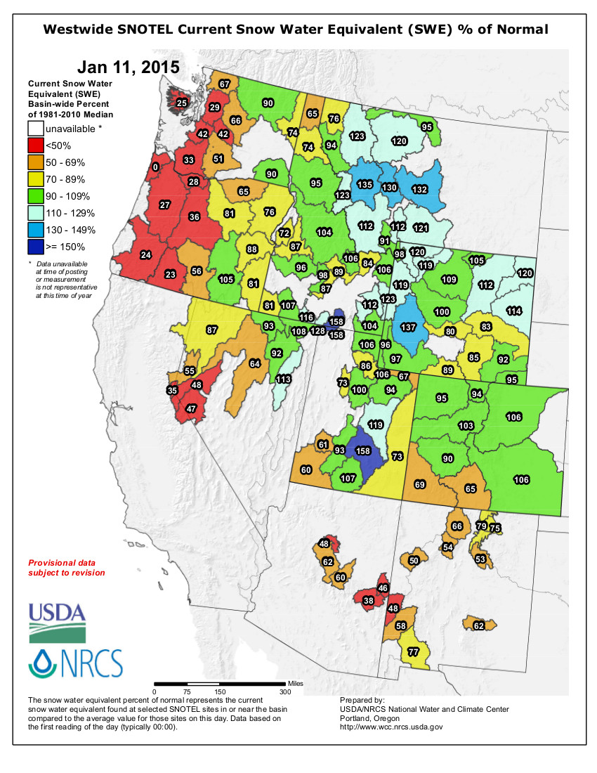
From The Grand Junction Daily Sentinel (Dave Buchanan):
Despite late-staying, unseasonably warm temperatures and almost no precipitation to remark of through the end of October, the statewide snowpack reached 99 percent of median as of Jan. 1, according to Brian Domonkos, Snow Survey Supervisor for the National Resources Conservation Service.
“The statewide snowpack is right where it needs to be for this time of year,” Domonkos said this week in the monthly snow survey report issued by the conservation service. “It’s difficult to make up an early deficit in snow accumulation, so being right at normal is a great place to be.”
The big boost came shortly before Christmas when a series of large storms swept across the state. Some ski resorts reported receiving close to three feet of new snow during one weekend storm cycle.
It has moderated a bit since then, but snow reports this week consistently are claiming midway bases in the high 20-inch to mid 30-inch range and more.
According to Colorado Ski Country USA, the top five resorts as of Friday were: Wolf Creek, 45-inch base; Copper Mountain, 44; Winter Park, 41; Telluride, 40; and Steamboat, 39.
As has been the rule over the past few years, the snowpack is divided, with the northern and Interstate 70 resorts benefitting from weather patterns and the southwest quadrant seeing the least snow.
The Upper Rio Grande and San Juan river basins are at 71 and 75 percent, respectively, of median.
The National Resources Conservation Service reports these river basins have not received a normal seasonal snowpack since 2010.
The shortfall in runoff in these basins is being felt as far away as Albuquerque, New Mexico, where, according to a story in the Albuquerque Journal, the San Juan-Chama Project, which diverts water from southwest Colorado and sends it via transmountain tunnels to central New Mexico, had the first shortfall this year in its 40-year history.
The water is part of the amount guaranteed to New Mexico in the Colorado River Compact of 1922.
The story, by Journal staff writer John Fleck, said three consecutive years of low snowpack have caused Heron Reservoir in the Rio Chama Basin to nearly run dry, and photos show a slip of water meandering past the New Mexico Sailing Club’s marina.
Albuquerque and Santa Fe, New Mexico, pull San-Juan Chama water from the Rio Grande for their local water supplies.
The story can be found on the website for the Water Center at Colorado Mesa University.
The state’s other major river basins are reporting much better conditions, ranging from 114 percent of median in the Colorado River Basin to 99 percent of median in the Gunnison Basin.
The South Platte River Basin east of the Continental Divide is reporting 112 percent of median.
From The Mountain Mail:
Statewide snow accumulation is off to a near normal start, the Natural Resources Conservation Service reported Thursday.
Snowpack in the Arkansas River Basin is above normal at 114 percent of the median.
Precipitation for December was 101 percent of average, which brings year-to-date precipitation to 105 percent of average.
At 99 percent of normal statewide on Jan. 1, Colorado’s snowpack is at exactly the same level as seen in 2001 and close to the totals recorded in 1995 and 2014.
The snowpack in the Arkansas River Basin is currently ranked 11th of the 35-year period of record.
Statewide snowpack totals range from 47 percent of normal in the Alamosa Creek drainage to 146 percent in the Upper Arkansas Basin.Reservoir storage at the end of December was 79 percent of average compared to 59 percent last year. Current streamflow forecasts range from 119 percent of average for Chalk Creek near Nathrop to 82 percent of average for the Cucharas River near La Veta.
Statewide reservoir storage is only slightly above normal through Jan. 1 at 103 percent of average. The Arkansas and Upper Rio Grande basins are the only two watersheds with storage totals below 80 percent of average.
Each major watershed has better storage than last year at the same time. The Arkansas’ combined reservoir storage is 20 percent higher than last year at this time.
From The Greeley Tribune (Kayla Young):
Snowpack in Colorado’s northern and eastern basins were at a healthy level this week, said Boulder-based meteorologist Robert Glancy of the National Weather Service.
Snow precipitation levels for the North and South Platte were at 101 and 109 percent of average, respectively, according to the most recent Colorado SNOTEL data.
If similar conditions persist, the basins will be in for good moisture levels come springtime, the meteorologist reported.
Broken down into a water equivalent, the South Platte River Basin index stood at 111 percent of the median, while the Laramie and North Platte River basin index was at 99 percent.
Snowpack above 150 percent of average places the basin at greater risk of flooding during runoff season, Glancy said.
In southwestern Colorado, hit by fewer winter storms so far than the north, basin snowpack ranged from 70 to 85 percent of average. The snow-water equivalent in the region ranged from 67 to 71 percent of the median, according to Colorado SNOTEL.
“The season is still young, so this could turn around,” Glancy said.
The winter season has yet to reach the halfway mark, set at Feb. 1, so there is still plenty of time for conditions to improve, he explained.
As for upcoming changes, Glancy said no serious storms were on the radar for the southern basins. If snowpack remains low in the south, it could mean dry conditions later in the year.
For the northern mountains, more snowfall was expected for early next week.
Reclamation: Daily water elevation of Lake Powell
#DidYouKnow you can see the daily water elevation of Lake Powell? http://t.co/8Esd2bLe3l
— Bureau of Reclamation (@usbr) January 11, 2015