
Come to this year’s Poudre River Forum Jan. 31 at the Ranch for a day of engaging dialog from diverse perspectives http://t.co/P5qWPll4Lb
— City of Fort Collins (@fortcollinsgov) January 20, 2015
Day: January 20, 2015
Water Lines: $8 million grant to fund Colorado irrigation improvements
From the Grand Junction Free Press (Hannah Holm):
Concern about environmental and water supply conditions in the Colorado River Basin helped a group of farmers and their partners in the lower Gunnison River Basin net an $8 million grant from the federal government to line and pipe open canal systems and to convert fields from flood irrigation to more efficient sprinkler, micro spray and drip systems.
The irrigation improvements will enable farmers to maintain or improve production with smaller diversions from rivers and streams. Reductions in the amount of water that soaks through the ground and back into tributaries of the Gunnison River as a result of flood irrigation and unlined canals will also improve water quality by reducing the amount of salt and selenium leaching out of soils and into the river. High salt levels in the river harm the productivity of downstream farms, while high selenium levels harm sensitive fish and bird species.
Projects funded by the grant will be implemented in partnership with four irrigation entities in different parts of the lower Gunnison Basin: the Bostwick Park Water Conservancy District southeast of Montrose; the Crawford Water Conservancy District near Crawford; the North Fork Water Conservancy District near Paonia and Hotchkiss; and the Uncompahgre Valley Water Users Association, located primarily between Montrose and Delta.
In a statement from the Colorado River District, the lead partner on the project, Colorado River District Senior Water Engineer Dave Kanzer, said: “This grant is a big ‘win-win-win’ for agricultural, economic and environmental sustainability.”
“It will really help our agricultural producers implement new conservation practices that not only produce more ‘crop per drop’ of water but significantly reduce their environmental footprint,” Kanzer continued.
This project builds on previous similar initiatives, but is distinguished from them by its scale, the fact that it is part of an integrated, basin-wide strategy and the leadership role taken by farmers. Participating farmers have organized themselves and partner organizations into a group called “No Chico Brush.” Chico Brush, also known as greasewood, would likely dominate the valleys of the lower Gunnison Basin if irrigated agriculture were to disappear.
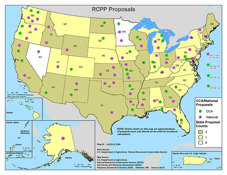
The Colorado River District expects the $8 million federal grant to leverage additional funding from other sources for a total of around $50 million. The federal funds were allocated through the Regional Conservation Partnership Program, an element of the 2015 Farm Bill. The competitiveness of the Gunnison Basin proposal benefitted from the fact that the Gunnison River lies within the Colorado River Basin, which the program identified as a “critical conservation area.”
The critical conservation area designation for the Colorado River Basin is due to a persistent regional drought that is exacerbating water supply and demand imbalances, as well as degradation of soil quality, water quality, and wildlife habitat. Agricultural irrigation is the largest consumer of water in the basin.
To learn more about the lower Gunnison irrigation improvement project, contact Kanzer at dkanzer@crwcd.org.
To learn more about the Regional Conservation Partnership Project, visit http://www.nrcs.usda.gov/wps/portal/nrcs/main/national/programs/farmbill/rcpp.
This is part of a series of articles coordinated by the Water Center at Colorado Mesa University in cooperation with the Colorado and Gunnison Basin Roundtables to raise awareness about water needs, uses and policies in our region. To learn more about the basin roundtables and statewide water planning, and to let the roundtables know what you think, go to http://www.coloradomesa.edu/WaterCenter. You can also find the Water Center on Facebook at Facebook.com/WaterCenter.CMU or Twitter at Twitter.com/WaterCenterCMU.
More Gunnison River Basin coverage here
Snowpack news: When will there be another good dump?

From the Vail Daily (Scott N. Miller) via the Glenwood Springs Post Independent:
At the National Weather Service office in Grand Junction, forecaster Paul Frisbie said there’s currently a double whammy working against snowfall in this part of the Rockies.
The first is a persistent high-pressure system over California. That system has brought warmer temperatures to California. The system is also keeping cooler air mostly to the north.
“There’s pretty good (atmospheric) moisture, but nothing really to get us going in terms of snowfall,” Frisbie said.
Also contributing to the lack of snowfall is the fact that the eastern portion of the U.S. has been seeing cold air coming south from Canada.
Joel Gratz, the Colorado meteorologist for OpenSnow.com, said the current weather patterns have put Colorado on the edge of current storm tracks as they come out of Canada. On a global scale, the problem is one of fairly small degrees. A shift of just 100 or 200 miles in the storm track can make a big difference in whether or not the Rockies see snow, Gratz said.
“Over the weekend, if this current pattern shifts to the east, we won’t see snow in the northern Rockies,” Gratz said. Again, a shift of 100 miles can make a big difference, but when a forecaster is working with very large swaths of the planet, it’s difficult to pin down how far west or east a weather pattern will establish itself.
That’s one of the reasons Gratz said these days he has a little more patience with his forecasts.
“We’ll often get a shift, but it doesn’t establish as fast as we think it will,” Gratz said. “I don’t want to call a shift until it really moves into place.”
All forecasters will acknowledge that weather predictions get much more uncertain more than seven or 10 days into the future. Further complicating the forecasting this season is the water in the Pacific Ocean off the west coast of South America. When water in that area is warmer than normal, it’s called an “El Niño” pattern. Cooler-than-normal water temperatures in that area define a “La Niña” pattern.
Frisbie said an El Niño pattern generally brings more moisture to North America, but those storms tend to track across the Southwest. La Niña patterns are somewhat drier, but tend to bring more storms through the Pacific Northwest. The big snow season of 2010 — 2011 was a La Niña year.
This season, the water temperatures in that part of the Pacific have stayed near average, and a shift now wouldn’t have an appreciable effect on future storms through the rest of the season. Near-average temperatures also makes weather patterns tougher to predict.
The good news, Frisbie said, is that the current pattern will break at some point, freeing up storms to again track across the Rockies.
For powder hounds, of course, that break can’t come too soon.
Gratz, whose voice mail message states he may well be out sampling the snow he forecasts, is in that company.
“Whenever it happens, the fact is we need more snow,” he said.
From The Durango Herald (Chuck Slothower) via the Mancos Times:
The mountain snowpack in Southwest Colorado remains below average after Tuesday’s storm.
The Colorado SNOTEL index of the San Miguel, Dolores, Animas and San Juan River basins was at 78 percent of the median figure for Wednesday’s date…Red Mountain Pass had the biggest snowpack in the region, at 101 percent of average snowpack for the date.
Some others:Mancos, 71 percent
Molas Lake, 78 percent
Spud Mountain, 76 percent
Vallecito, 93 percent
Wolf Creek Summit, 53 percent
[December 13, 2015’s] storm dropped 6 to 8 inches in many parts of La Plata County, and a foot or more at some locations in the mountains.
First lease-fallowing pilot project under HB13-1248 to move to CWCB next week

From The Pueblo Chieftain (Chris Woodka):
A state engineer’s review of a plan to lease water from the Catlin Canal to upstream cities will move to the Colorado Water Conservation Board later next week. The state board is scheduled to review the plan on Jan. 26, the first day of its two-day meeting in Denver.
The plan is the first pilot project under 2013 legislation, HB1248, that allows the CWCB to review projects that lease water from farms to cities on a long-term, temporary basis. In order to provide the water, agricultural land must be dried up during the lease. No more than 30 percent of any given farm may be fallowed during the 10-year lease period.
Seven farms with 1,128 acres on the Catlin Canal will be dried up on a rotational basis to provide up to 500 acre-feet (163 million gallons) per year to three municipal water users: Fowler in Otero County, and Fountain and the Security Water and Sanitation District in El Paso County. If approved, the lease would begin this year.
The CWCB accepted the project in September, but will look at the details in the upcoming review. The state engineer’s office reviewed the plans in a way similar to a water court application or substitute water supply plan.
Bill Tyner, assistant Water Division 2 engineer, told the Southeastern Colorado Water Conservancy District Thursday that a review of the application has been completed and will go to the CWCB next week with a recommendation to proceed.
The review included concerns about impacts on other water rights from Southeastern and other groups in the Arkansas Valley.
“It’s an important time in the Arkansas River basin for those who have tired to get a lease-fallowing program going. It’s finally going to occur,” Tyner said.
The program is supported by the Arkansas Valley Super Ditch, a corporation that includes members from several ditches, as well as the Lower Arkansas Valley Water Conservancy District.
More HB13-1248 coverage here. More Arkansas River Basin coverage here.