Yes, there are rivers in the sky! Atmospheric rivers, to be exact, are narrow bands of moisture that regularly form above the Pacific Ocean and flow towards North America’s west coast, drenching it in rain and packing it with snow. These rivers, which transport more water than the Amazon or the Mississippi, have a far-reaching impact – even on the food you may be eating today.
With the January 14 sailing of NOAA’s largest ship, the Ronald H. Brown, a major investigation of atmospheric rivers named CalWater 2015 is now underway.
With the January 14 sailing of NOAA’s largest ship, the Ronald H. Brown, a major investigation of atmospheric rivers named CalWater 2015 is now underway.
“Improving our understanding of atmospheric rivers will help us produce better forecasts of where they will hit and when, and how much rain and snow they will deliver,” said Chris Fairall, the chief of Weather and Climate Physics at NOAA’s Office of Oceanic and Atmospheric Research Earth System Research Laboratory in Boulder, Colorado.
While atmospheric rivers impact the entire West Coast, they are particularly important for California, where they can deliver half of the state’s total annual precipitation in just a few storms.
California produces nearly half of all the fruits, vegetables and nuts grown in the United States, requiring an enormous amount of water. If it were its own country, California would be the eighth largest economy in the world – larger than Italy or Russia. Interruptions to the water supply impact not only the agriculture, industry, wildlife, and citizens of the state, but the nation as a whole.
With California currently facing one of the most severe droughts on record, the mission could not be more pressing: atmospheric rivers are collectively drought breakers – though they can also cause serious and dangerous flooding.
The Pineapple Express
TV weather forecasters in California in the 1960s noticed the atmospheric rivers traveling from an area near Hawaii to the West Coast and dubbed the phenomenon the Pineapple Express.
“But the atmospheric rivers sometimes flow north towards Alaska, bypassing California altogether. Or they may arrive in California but with much less precipitation than usual,” said Fairall. Fifteen years ago scientists began to study these changes and how to better anticipate them.
One question CalWater 2015 is investigating is the degree to which precipitation from atmospheric rivers is affected by aerosols. Aerosols, in scientific parlance, do not refer to spray cans but to particles suspended in the air, such as dust or pollen or pollution. Moisture in the air condenses around such particles and this is what forms clouds and rain.
Scientists are learning that not all particles produce the same kind of precipitation under the same conditions. For example, particles blown from the deserts of Africa via the jet stream may have more precipitation forming qualities than local man-made pollutants, which may actually decrease precipitation. Some particles may also be better at forming snow versus rain, a critical difference in the Sierras where the snowpack serves as California’s biggest reservoir.
CalWater 2015 is also investigating what proportion of the water falling on California originated at the rivers’ “source” in the tropics, and how much was picked up from the ocean along its 3,000 mile route.
“I was quite surprised by some early analyses that indicate the rivers may actually be picking up very little water along the way. This is one of the things I’ll be measuring at sea on the Ron Brown,” said Fairall.
An Armada’s effort
Flying through rivers in the sky Scientists aboard NOAA hurricane hunter aircraft will measure wind, air pressure and moisture while flying through atmospheric rivers. (NOAA)
CalWater 2015 will simultaneously employ, in addition to NOAA Ship Ronald H. Brown, two highly specialized NOAA aircraft, the Lockheed WP-3D Orion and Gulfstream IV-SP “hurricane hunters”; NASA and Department of Energy aircraft; NOAA satellites; roughly 100 ground stations; and hundreds of weather balloons, all being deployed into the line of storm activity of two to three anticipated atmospheric rivers.
NOAA Ship Ronald H. Brown’s commanding officer, Capt. Robert A. Kamphaus, explains that, while it may seem counterintuitive to put a ship in the path of a winter storm, “the Brown is a very seaworthy and capable platform with a great crew.” The crew will also closely watch National Weather Service forecasts. “I’m confident we will meet the project objectives while keeping the ship and all aboard safe,” said Kamphaus.
Environmental intelligence
The goal of CalWater 2015 is the same as the mission of NOAA: to provide environmental intelligence. This intelligence will be used by water resource managers in many fields, including those involved with agriculture and flood control.
The risk of severe flooding from atmospheric rivers can be significant, and environmental information can save lives, property, and money. With severe weather forecasting, every hour counts.
“Flooding, besides being a serious life and limb hazard, has other impacts, such as mudslides, transportation issues, sewage overflowing into the ocean…It even affects the management of salmon and steelhead. Better forecasts derived from the data we are collecting this month will make it easier to manage all of it,” said Fairall.
The CalWater 2015 field campaign runs from January 14, 2015 to mid-March 2015. Leading agencies are NOAA; Scripps Institution of Oceanography; NASA; the Department of Energy; the Naval Research Laboratory; and the State of California. Other partners include CIRES, the Cooperative Institute for Research in Environmental Sciences, and STC, Science and Technology Corporation. CalWater 2015 evolved out of an ongoing NOAA Earth System Research Laboratory project called the Hydrometeorology Testbed.
Colorado Corn allocates tens of thousands of dollars annually to research endeavors, and has already made sure 2015 will be no different.
Colorado Corn’s Research Action Team this month committed $101,595 to research projects, with the bulk of the funds spent on water-focused efforts. Following all-day meetings and presentations, Colorado Corn’s Research Action Team agreed to fund the following endeavors:
* $30,425, to Colorado State University’s Troy Bauder and Erik Wardle, for their “BMP Research and Demonstration” project, which, over the next two years, will monitor the effects of improved nutrient management methods commonly practiced by corn growers, to better understand the agronomic and water quality benefits from these practices. This is expected to be useful in a triennial review for the Colorado Water Quality Control Commission, helping quantify the good work producers are already doing in this area.
* $26,700, to Erick Carlson at CSU, to develop additional methods for reducing the deep percolation of nitrates into groundwater, through investigating the functioning of wetlands created by irrigation runoff.
* $25,000, to CSU’s Phil Westra and Scott Nissen, for various objectives at the Center for Ecology, Evolution & Management of Pesticide Resistance.
* $15,604, to Louise Comas with the USDA’s Agricultural Research Service, to create a tool that will help corn producers identify when their crop is going into stress, help estimate potential yield impacts of that stress, and help dry-land and irrigated producers assess potential effects from constraints in their water supply.
* $3,866, to Joel Schneekloth with the Colorado Water Institute, to study the impact of residue removal and tillage upon the soil characteristics important to crop production and crop-production economics.
A plan to coordinate efforts to prevent and respond to large burns in watersheds is spreading like, well, wildfire.
The Arkansas Basin Roundtable last week agreed to ask the Colorado Water Conservation Board for $265,000 toward an $821,000 plan to launch the Arkansas River Watershed Collaborative.
The funding includes three projects designed to reduce wildfire risk in separate parts of the Arkansas River watershed.
Watershed protection is crucial to protecting water supplies, since fires destroy plants, ruin the ability of soil to absorb water and increase silt or debris during fierce runoffs.
“The Arkansas River Watershed Collaborative started in response to the catastrophic wildfires of 2012-13,” said Mark Shea, a Colorado Springs Utilities employee who co-chairs the group.
Those fires included the Waldo Canyon and Black Forest fires near Colorado Springs, the East Peak Fire near La Veta and the Royal Gorge Fire near Canon City, as well as many smaller fires.
Earlier, there had been grassland fires on the Eastern Plains during the prolonged drought of the last few years.
At the December roundtable meeting, Shea presented the case for coordinating wildfire response efforts throughout the entire Arkansas River basin to control fires.
Since then, a full package of how the group would function has been prepared.
“We’re planning to have a meeting in February to get folks started talking,” said Carol Ekarius, executive director of the Coalition for the Upper South Platte.
The projects that would be funded by the state grant include mitigation in the Purgatoire, Cucharas and Tennessee Creek watersheds. They total about $110,000 of the state grant money, as well as $308,000 in matching funds from other sources.
The rest of the funding will go toward organization, data collection, strategic planning and public outreach and education.
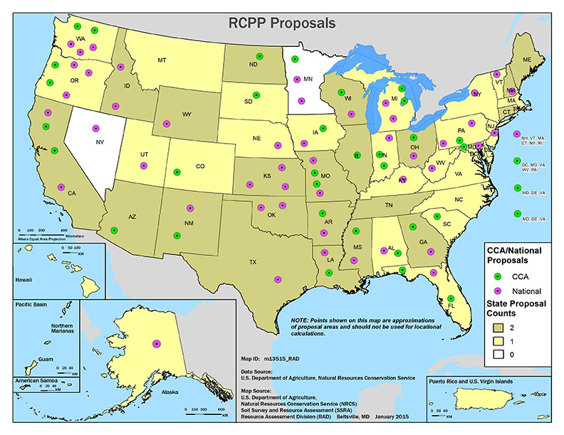
RCPP Proposals map via the USDA From the Grand Junction Free Press (Hannah Holm):
Concern about environmental and water supply conditions in the Colorado River Basin helped a group of farmers and their partners in the lower Gunnison River Basin net an $8 million grant from the federal government to line and pipe open canal systems and to convert fields from flood irrigation to more efficient sprinkler, micro spray and drip systems.
The irrigation improvements will enable farmers to maintain or improve production with smaller diversions from rivers and streams. Reductions in the amount of water that soaks through the ground and back into tributaries of the Gunnison River as a result of flood irrigation and unlined canals will also improve water quality by reducing the amount of salt and selenium leaching out of soils and into the river. High salt levels in the river harm the productivity of downstream farms, while high selenium levels harm sensitive fish and bird species.
Projects funded by the grant will be implemented in partnership with four irrigation entities in different parts of the lower Gunnison Basin: the Bostwick Park Water Conservancy District southeast of Montrose; the Crawford Water Conservancy District near Crawford; the North Fork Water Conservancy District near Paonia and Hotchkiss; and the Uncompahgre Valley Water Users Association, located primarily between Montrose and Delta.
In a statement from the Colorado River District, the lead partner on the project, Colorado River District Senior Water Engineer Dave Kanzer, said: “This grant is a big ‘win-win-win’ for agricultural, economic and environmental sustainability.”
“It will really help our agricultural producers implement new conservation practices that not only produce more ‘crop per drop’ of water but significantly reduce their environmental footprint,” Kanzer continued.
This project builds on previous similar initiatives, but is distinguished from them by its scale, the fact that it is part of an integrated, basin-wide strategy and the leadership role taken by farmers. Participating farmers have organized themselves and partner organizations into a group called “No Chico Brush.” Chico Brush, also known as greasewood, would likely dominate the valleys of the lower Gunnison Basin if irrigated agriculture were to disappear.
The Colorado River District expects the $8 million federal grant to leverage additional funding from other sources for a total of around $50 million. The federal funds were allocated through the Regional Conservation Partnership Program, an element of the 2015 Farm Bill. The competitiveness of the Gunnison Basin proposal benefitted from the fact that the Gunnison River lies within the Colorado River Basin, which the program identified as a “critical conservation area.”
The critical conservation area designation for the Colorado River Basin is due to a persistent regional drought that is exacerbating water supply and demand imbalances, as well as degradation of soil quality, water quality, and wildlife habitat. Agricultural irrigation is the largest consumer of water in the basin.
To learn more about the lower Gunnison irrigation improvement project, contact Kanzer at dkanzer@crwcd.org.
This is part of a series of articles coordinated by the Water Center at Colorado Mesa University in cooperation with the Colorado and Gunnison Basin Roundtables to raise awareness about water needs, uses and policies in our region. To learn more about the basin roundtables and statewide water planning, and to let the roundtables know what you think, go to http://www.coloradomesa.edu/WaterCenter. You can also find the Water Center on Facebook at Facebook.com/WaterCenter.CMU or Twitter at Twitter.com/WaterCenterCMU.
Westwide SNOTEL snow water equivalent as a percent of normal January 19, 2015 via the NRCS
From the Vail Daily (Scott N. Miller) via the Glenwood Springs Post Independent:
At the National Weather Service office in Grand Junction, forecaster Paul Frisbie said there’s currently a double whammy working against snowfall in this part of the Rockies.
The first is a persistent high-pressure system over California. That system has brought warmer temperatures to California. The system is also keeping cooler air mostly to the north.
“There’s pretty good (atmospheric) moisture, but nothing really to get us going in terms of snowfall,” Frisbie said.
Also contributing to the lack of snowfall is the fact that the eastern portion of the U.S. has been seeing cold air coming south from Canada.
Joel Gratz, the Colorado meteorologist for OpenSnow.com, said the current weather patterns have put Colorado on the edge of current storm tracks as they come out of Canada. On a global scale, the problem is one of fairly small degrees. A shift of just 100 or 200 miles in the storm track can make a big difference in whether or not the Rockies see snow, Gratz said.
“Over the weekend, if this current pattern shifts to the east, we won’t see snow in the northern Rockies,” Gratz said. Again, a shift of 100 miles can make a big difference, but when a forecaster is working with very large swaths of the planet, it’s difficult to pin down how far west or east a weather pattern will establish itself.
That’s one of the reasons Gratz said these days he has a little more patience with his forecasts.
“We’ll often get a shift, but it doesn’t establish as fast as we think it will,” Gratz said. “I don’t want to call a shift until it really moves into place.”
All forecasters will acknowledge that weather predictions get much more uncertain more than seven or 10 days into the future. Further complicating the forecasting this season is the water in the Pacific Ocean off the west coast of South America. When water in that area is warmer than normal, it’s called an “El Niño” pattern. Cooler-than-normal water temperatures in that area define a “La Niña” pattern.
Frisbie said an El Niño pattern generally brings more moisture to North America, but those storms tend to track across the Southwest. La Niña patterns are somewhat drier, but tend to bring more storms through the Pacific Northwest. The big snow season of 2010 — 2011 was a La Niña year.
This season, the water temperatures in that part of the Pacific have stayed near average, and a shift now wouldn’t have an appreciable effect on future storms through the rest of the season. Near-average temperatures also makes weather patterns tougher to predict.
The good news, Frisbie said, is that the current pattern will break at some point, freeing up storms to again track across the Rockies.
For powder hounds, of course, that break can’t come too soon.
Gratz, whose voice mail message states he may well be out sampling the snow he forecasts, is in that company.
“Whenever it happens, the fact is we need more snow,” he said.
FromThe Durango Herald (Chuck Slothower) via the Mancos Times:
The mountain snowpack in Southwest Colorado remains below average after Tuesday’s storm.
The Colorado SNOTEL index of the San Miguel, Dolores, Animas and San Juan River basins was at 78 percent of the median figure for Wednesday’s date…
Red Mountain Pass had the biggest snowpack in the region, at 101 percent of average snowpack for the date.
Some others:
Mancos, 71 percent
Molas Lake, 78 percent
Spud Mountain, 76 percent
Vallecito, 93 percent
Wolf Creek Summit, 53 percent
[December 13, 2015’s] storm dropped 6 to 8 inches in many parts of La Plata County, and a foot or more at some locations in the mountains.
A state engineer’s review of a plan to lease water from the Catlin Canal to upstream cities will move to the Colorado Water Conservation Board later next week. The state board is scheduled to review the plan on Jan. 26, the first day of its two-day meeting in Denver.
The plan is the first pilot project under 2013 legislation, HB1248, that allows the CWCB to review projects that lease water from farms to cities on a long-term, temporary basis. In order to provide the water, agricultural land must be dried up during the lease. No more than 30 percent of any given farm may be fallowed during the 10-year lease period.
Seven farms with 1,128 acres on the Catlin Canal will be dried up on a rotational basis to provide up to 500 acre-feet (163 million gallons) per year to three municipal water users: Fowler in Otero County, and Fountain and the Security Water and Sanitation District in El Paso County. If approved, the lease would begin this year.
The CWCB accepted the project in September, but will look at the details in the upcoming review. The state engineer’s office reviewed the plans in a way similar to a water court application or substitute water supply plan.
Bill Tyner, assistant Water Division 2 engineer, told the Southeastern Colorado Water Conservancy District Thursday that a review of the application has been completed and will go to the CWCB next week with a recommendation to proceed.
The review included concerns about impacts on other water rights from Southeastern and other groups in the Arkansas Valley.
“It’s an important time in the Arkansas River basin for those who have tired to get a lease-fallowing program going. It’s finally going to occur,” Tyner said.
The program is supported by the Arkansas Valley Super Ditch, a corporation that includes members from several ditches, as well as the Lower Arkansas Valley Water Conservancy District.
More HB13-1248 coverage here. More Arkansas River Basin coverage here.
On October 14, 1964, King received the Nobel Peace Prize for combating racial inequality through nonviolence. In 1965, he and the SCLC helped to organize the Selma to Montgomery marches and the following year, he took the movement north to Chicago to work on segregated housing. In the final years of his life, King expanded his focus to include poverty and speak against the Vietnam War, alienating many of his liberal allies with a 1967 speech titled “Beyond Vietnam”.
In 1968, King was planning a national occupation of Washington, D.C., to be called the Poor People’s Campaign, when he was assassinated on April 4 in Memphis, Tennessee. His death was followed by riots in many U.S. cities. Allegations that James Earl Ray, the man convicted of killing King, had been framed or acted in concert with government agents persisted for decades after the shooting.
King was posthumously awarded the Presidential Medal of Freedom and the Congressional Gold Medal. Martin Luther King, Jr. Day was established as a holiday in numerous cities and states beginning in 1971, and as a U.S. federal holiday in 1986. Hundreds of streets in the U.S. have been renamed in his honor. In addition, a county was rededicated in his honor. A memorial statue on the National Mall was opened to the public in 2011.
Can the Western Slope ever come to terms with a future proposal to move water across the Continental Divide?
That’s one question that is emerging as the state water plan moves into its sophomore year.
Part of the draft water plan presented to Gov. John Hickenlooper in December includes principles for Colorado River Development.
The issue has been a stumbling block in the quest to get agreement from all water basins in the state about how to provide new water supplies. It stymied a task force formed several years ago to look at whether a pipeline from Flaming Gorge Reservoir in Wyoming could be built. Denver Water went its own way in obtaining a cooperative agreement with diverse Western Slope interests.
“I had hoped we could get away from the Western Slope position of not one damn more drop,” said Jeris Danielson, a former state engineer who now manages the Purgatoire Water Conservancy District. “I believe the Western Slope will sabotage any attempt to develop more water.”
Danielson made his comments at the Arkansas Basin Roundtable meeting last week. He represents the roundtable on the Interbasin Compact Committee. Both were created in 2005, partly for the reason of ironing out disputes between basins.
The groups formed in a period of statewide drought when the Legislature was looking for an alternative to the long-standing practice of agricultural dry-up to slake urban thirst. The issue of maintaining or increasing water imports is vital to Front Range communities, including Pueblo, as water supplies in the Arkansas and South Platte river basins are fully spoken for and being used.
The Colorado River basin has conditional water rights in place for more water than is available, but much of that is by oil shale companies that have never developed the water rights. Danielson said excess water is available much of the time and Colorado has a right to use it under the Colorado River Compact.
One of the things the IBCC managed to accomplish in the first 10 years of meetings was a draft conceptual agreement. The key points of the agreements boil down to:
Making the Front Range and Eastern Colorado projects.
Development of compensatory projects for the Western Slope.
Establish triggers for times when water could be moved, because of compact calls.
Accommodating future Western Slope needs.
Improving urban and agricultural conservation and reuse.
Incorporating environmental and recreation needs for water.
The Roundtable touched the surface of only one or two of those points at its meeting last week, but accepted those points as a starting place for IBCC discussions, which are expected to continue when it meets in Denver next week.
Jay Winner, the roundtable’s other IBCC representative, said more talk about the principles is not the way to go. He noted that a recent Gunnison Basin “white paper” appears poised to set the process back.
“It took us a year to get to this point,” Winner said. “I’m tired of white papers. We need a project.”
FromThe Grand Junction Daily Sentinel (Anne-Mariah Tapp and David M. Abelson):
As the new Congress ramps up in the coming weeks, energy policy will quickly top the list of priorities. Debates over the Keystone Pipeline, natural gas exports, and climate change may dominate, but they won’t be the only issues demanding Congress’ attention. In the West, the link between energy development and water use has never been more dire. And for the Colorado River Basin’s 40 million residents —and the water they depend on — a critical piece of legislation on the docket is the PIONEERS Act.
The PIONEERS Act seeks to jumpstart the non-existent oil shale industry in Colorado, Utah and Wyoming for private gain at the expense of Colorado River Basin water resources. Oil shale, the poor cousin of the shale oil and fracking boom, is technically feasible to extract, but in 100 years of dogged attempts by the federal government and the oil industry, extracting it has never turned a profit. Now provisions in the PIONEERS Act attempt to improve the economics by providing federal subsidies in the form of cheap public land and below-market royalties.
In securing passage of the PIONEERS Act in the past three sessions of Congress (each time the bill has been thwarted in the Senate), Colorado Reps. Doug Lamborn and Scott Tipton have maintained that oil shale development, should the technologies be successfully commercialized, would require little water. This claim seems to be based solely on public assurances made by the oil industry. However, recent water court filings by oil shale developers now cast doubt upon these assurances, and it’s time for Lamborn and Tipton to reconsider their endorsement of the industry.
In recent months, oil shale industry leaders Chevron Oil and ExxonMobil have undercut Lamborn and Tipton’s lead talking point. Chevron filed a lengthy report in Colorado water court showing that the company’s proposed oil shale development activities alone would require up to 125,000 acre-feet of water per year. That’s enough to supply more than half of Denver Water’s 2.3 million customers. ExxonMobil is seeking rights to even more water than Chevron, saying oil shale’s water demands “are anticipated to be higher than that of other sectors.” Other companies across the Colorado River Basin are also pursuing water rights to support oil shale operations.
For those of us who actually depend on Colorado River water to live, from the headwaters in Colorado to the delta in California, these projected water demands are alarming. By 2050, when oil shale supporters predict a mature industry might flourish, the competition for water could be extreme, pitting vital agriculture and recreation economies against a burgeoning population and water-intensive energy demands. If oil shale indeed develops at a large-scale, the family farm — the bedrock of our rural communities and a critical economic driver for our region — will face a full-court press from industry for water rights.
Even without oil shale development, water providers throughout the Colorado River Basin will be hard-pressed to meet existing and future demand. Colorado’s Water Plan, published in December 2014, indicates that by 2050, the gap between water availability and demand will be roughly 500,000 acre-feet, more water than the cities of Denver, Salt Lake City and Albuquerque collectively use in a year. Oil shale gets scant attention in this analysis, but developing these deposits would increase the gap and further strain water supplies.
As James Eklund, director of the Colorado Water Conservation Board, has noted, “No single issue will have a more direct impact on Colorado’s future than our ability to successfully and collaboratively manage our life-giving water.” This challenge is not unique to Colorado. States throughout the West are grappling with complex supply and demand questions.
As Congress takes up the PIONEERS Act and considers whether to fast-track oil shale development in the Colorado River Basin, it’s time to examine supporters’ key talking point that oil shale won’t use much water. We must remember the court filings and hold our elected officials accountable. There is too much riding on the myth that oil shale wouldn’t require much of a far more precious resource: water.
Halligan Reservoir From the Fort Collins Coloradoan (Kevin Dougan):
An environmental review of the proposed expansion of a Fort Collins reservoir is moving forward with its separation from a Greeley water project.
The U.S. Army Corps of Engineers plans to consider the city’s proposal to more than double the storage capacity of Halligan Reservoir as a separate project rather than in combination with Greeley’s proposal to enlarge its Seaman Reservoir.
Both reservoirs are on the North Fork of the Poudre River. The projects have been combined under the Corps’ review process since 2006, when the cities formally proposed enlarging the reservoirs to meet future water demand.
The projects were combined because their operations were expected to be coordinated in order to impact on the river as little as possible, said Donnie Dustin, water resources manager with Fort Collins Utilities.
As part of the environmental impact statement, or EIS, process required by federal regulations, alternatives to the proposed expansions must be considered by the Corps.
Fort Collins has its alternatives lined up and ready while Greeley needs more time to develop its alternatives, Dustin said.
“The benefit of separation is Fort Collins gets to move forward without waiting for Greeley,” he said. “And Greeley gets to take their time to reassess alternatives with the Corps for their project. Both projects benefit.”
A draft EIS for the Halligan is expected to be released in spring 2016, Dustin said.
Halligan Reservoir is about 100 years old. Its capacity is about 6,400 acre feet of water…
The city’s current request is to add 8,125 acre feet to the reservoir by raising its dam about 25 feet, Dustin said.
Fort Collins has requested the expansion to shore up its water supply to protect against drought.
The city needs the increased storage capacity “now,” Dustin said. Greeley does not plan to expand Seaman Reservoir for several years.
“Just given where we are right now, it just didn’t make sense to stay together,” he said.
The Halligan-Seaman project initially included the cities in partnership with the North Poudre Irrigation Co. as well as the Fort Collins-Loveland, East Larimer County and North Weld County water districts, also know as the Tri-Districts.
The water providers proposed expanding Halligan by 40,000 acre feet. The Tri-Districts withdrew from the project in 2009 citing mounting costs and a lack or progress on the environmental studies.
North Poudre withdrew in 2014 for the over the same concerns.
So far, costs related to the permitting process have reached $7.7 million, with Fort Collins paying about $4.5 million, officials said.
The negotiation of the 1922 Colorado River Compact governing the allocation of water from the West’s great river, and the ratification process that followed, was a politically delicate process.
Precisely how delicate is made clear in a fascinating exchange of letters 10 years after between Colorado attorney Delph Carpenter (the compact’s primary architect) and Norcutt Ely, who at the time was executive assistant to Interior Secretary Ray Lyman Wilbur.
The Compact Commission’s 27 sessions were largely closed affairs, though detailed minutes were kept…
…they were stashed in a “small room” at the Commerce Department. Carpenter suggests several people who might know where they were, and that they be forwarded to the state representatives “before they become lost”.
Whether or not Closed Basin Project water can be used to offset injurious depletions in the San Luis Valley’s first water management sub-district is a question resting with the Colorado Supreme Court.
If the higher court decides project water is not appropriate for that purpose, water management sub-districts would have to find about 9,000 acre feet of water from other sources, according to Steve Vandiver, general manager for the sub-districts ‘ sponsoring district, the Rio Grande Water Conservation District. Vandiver reported on the status of the sub-districts and associated legal action during the Rio Grande Roundtable meeting this week in Alamosa .
“We are still waiting on the Colorado Supreme Court decision on the use of Closed Basin Project water for our depletions’ replacement,” Vandiver said. “Nobody knows when it will come out.”
He said the court held a hearing the end of September, and decisions usually follow within four or five months.
The sponsoring water district and its first and subsequently pending sub-districts are hopeful the higher court will allow the Closed Basin Project water to be used to replace depletions caused by wells in the basin (San Luis Valley), Vandiver said. He said if the court decides against that, it would double the amount of money that has to be spent to meet water replacement obligations and require another 9,000 acre feet of water to be acquired and stored.
“It’s a very critical decision ,” he said. “We still have to meet the requirements, whether or not we can use that source for replacing depletions.”
Opponents to the use of Closed Basin Project water for depletions maintain it is double dipping to use water from the federal water salvage project to both meet Rio Grande Compact obligations and sub-district depletions at the same time. They also argue that it would be inappropriate to use well water, which would always be junior to surface senior water rights, to replace depletions to senior rights caused by other wells.
Sub-district #1 has used Closed Basin Project to help replace depletions since 2012. Vandiver said this week that currently Closed Basin Project water is being used on a daily basis to replace depletions owed during the current annual replacement plan year, which ends the end of April. The next annual replacement plan for Subdistrict #1 is due April 15.
He said WildEarth Guardians filed a Freedom Of Information Act request for all documents regarding the Closed Basin Project since its inception, but he did not know what the group intended to use the information for.
Vandiver said the subdistrict likely to be completed next is Sub-district #2, covering wells in the alluvial system directly tied to the Rio Grande. It has the fewest number of wells and well owners. Many have already filed petitions to be in the subdistrict , and the sub-district’s working group hopes to finish the petition process by the end of this month and present their sub-district for formal approval to the Rio Grande Water Conservation District board during its March meeting .
Sub-district #4 goes underneath Sub-district #2 and picks up all the confined wells, Vandiver added. Other subdistricts cover other areas in the Valley such as Conejos River, San Luis Creek and Saguache Creek.
Vandiver said all of the subdistricts are moving forward so they can be in place before the state rules and regulations governing groundwater come into force.
Here’s the release from the United States Department of Agriculture (Petra Barnes). (Click through for the data):
Agriculture Secretary Tom Vilsack today announced that 100 high-impact projects across all 50 states, including Colorado will receive more than $370 million as part of the new Regional Conservation Partnership Program (RCPP).
RCPP’s historic focus on public-private partnership enables private companies, local communities and other non-government partners a way to invest in efforts to keep our land resilient and water clean, and promote tremendous economic growth in agriculture, construction, tourism and outdoor recreation, and other industries.
This year’s projects in Colorado will accomplish a wide diversity of agricultural and natural resource goals from facilitating the conversion of flood irrigation systems to more resource-efficient pressurized irrigation systems with integrated hydropower to significantly increasing water use efficiency by coordinating expanded efforts and by integrating off-farm irrigation conveyance system and on-farm water application efficiency improvements.
“Partners are seeing the value of conservation and investing in their future,” Vilsack said. “These partnerships are forging a new path for getting conservation on the ground and are providing opportunities for communities to have a voice and ownership in protecting and improving our natural resources. The Regional Conservation Partnership Program ushers in a new era of conservation, and we’re excited about the down-the-road benefits from this new Farm Bill program.”
This year’s projects will engage hundreds of partners with wide-ranging interests, including communities, conservation districts, agribusiness, non-government organizations, for- and non-profit organizations, state and federal agencies and Tribal governments. In addition to USDA funds, partners’ will contribute an estimated $400 million, more than doubling USDA’s investment.
“RCPP puts our partners in the driver’s seat,” said Elise Boeke, Acting USDA’S Natural Resources Conservation Service state conservationist in Colorado. “Projects are led locally, and demonstrate the value of strong public-private partnerships that deliver solutions to tough natural resource challenges.”
More than 600 pre-proposals were submitted for RCPP in 2014. Of those, more than 200 were invited to submit full proposals. “With so many strong project proposals, the project selection process was extremely competitive. RCPP is a 5-year $1.2 billion USDA commitment; projects not selected in this first year may be eligible in subsequent years,” Boeke said.
To learn about technical and financial assistance available through conservation programs, visit http://www.nrcs.usda.gov/GetStarted or local USDA service center.
Uncompahgre River Valley looking south
FromThe Grand Junction Daily Sentinel (Gary Harmon):
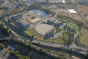
Nearly $10 million in federal funding will go to boost water efficiency in the Gunnison Basin and boost the generation of electricity from irrigation systems.
The Colorado River Water Conservation District will administer $8 million to be used with regional conservation partnership programs, which were established in the 2014 Farm Bill, to use water more efficiently and reduce the amount of salts and selenium carried in the Colorado River and its tributaries.
The grant “will really help our agricultural producers implement new conservation practices that not only produce more ‘crop per drop’ of water, but significantly reduces their environmental footprint,” said Dave Kanzer, senior water resources engineer for the River District.
The agency will coordinate efforts to boost water efficiency by coordinating canals, ditches and pipes that deliver water to farms with improvements in the way water is delivered to crops, frequently by eliminating flood irrigation in favor of sprinkler and other irrigation systems.
The River District will use the money from the Agriculture Department to match funding from the Interior Department, as well as state, local and River District funds, to pay for the projects, Kanzer said.
“This grant is a big win-win for agricultural, economic and environmental sustainability,” Kanzer said.
The program will focus on the Bostwick Park, North Fork and Crawford water conservancy districts, as well as the Uncompahgre Valley Water Users Association, for the projects, Kanzer said.
Micro-hydroelectric plant
The Colorado Department of Agriculture will coordinate a $1.8 million grant to support development of hydropower generation from agricultural canals and ditches.
Congress previously approved legislation easing the development of small hydropower projects by U.S, Rep. Scott Tipton, R-Colo.
Tipton and U.S. Sen. Michael Bennet, D-Colo., each served on their houses’ respective agriculture committees, which crafted the Farm Bill.
“These projects will help Colorado and other states across the West better manage our water resources in the face of increased demand and persistent drought conditions,” Bennet said in a statement.
More conservation coverage here. More hydroelectric/hydropower coverage here
Controlling stormwater on Fountain Creek has surfaced as a key issue for use of the Southern Delivery System in light of the rejection of the Pikes Peak Drainage Authority by El Paso County voters in November.
A proposal to use the SDS pipeline to deliver water to a system just north of Colorado Springs could be a test of Pueblo County’s 1041 regulations for SDS.
Donala Water and Sanitation District has asked for an exemption or finding of no significant impact from Pueblo County 1041 conditions on its plan to move water from rights it purchased in 2009 on the Willow Creek Ranch south of Leadville.
A Pueblo County analysis of votes in the Donala district shows its residents rejected stormwater control by a 60-40 margin.
“Serious concerns over compliance with (1041 conditions) are raised by the failed efforts in El Paso County, including within the city of Colorado Springs and Donala, at establishing, financing and maintaining stormwater controls,” Pueblo County Planner Joan Armstrong wrote in a letter to Donala last week.
“The recent failure of the November ballot proposal in El Paso County on stormwater fees only heightened those concerns.”
Donala plans to use excess capacity in the SDS pipeline from Pueblo Dam to Colorado Springs and a conveyance agreement with Colorado Springs Utilities to move an average of about 436 acre-feet (143 million gallons).
SDS is not expected to come on line until at least 2016, and Donala is not the only community interested in using it. Colorado Springs has the majority of capacity in the line, which won’t reach its full volume of 78 million gallons daily for several decades.
The move would provide about one-third of the water for 2,600 taps serving 8,000 people in the Donala district. It also would reduce Donala’s dependence on non-renewable groundwater from the Denver Basin aquifer.
Donala asked for the exemption because the amount of water falls short of the 500-acrefoot threshold that normally would trigger a 1041 permit review.
Armstrong asked Donala to address the question of whether larger amounts of water could be moved through the pipeline.
She also explained that the county also is interested in the maximum — not just the average — flows that could be moved to Donala through SDS, and in complying with certain conditions of the 1041 permit for SDS, including stormwater control.
The county asked Donala if it still intends to amend its service plan to control stormwater, as manager Kip Peterson indicated in a 2013 interview with The Pueblo Chieftain.
The county also wants to know which of the projects identified in the 2013 El Paso County Stormwater Needs Assessment by CH2MHill would serve Donala and whether the district intends to fund or construct any of those projects.
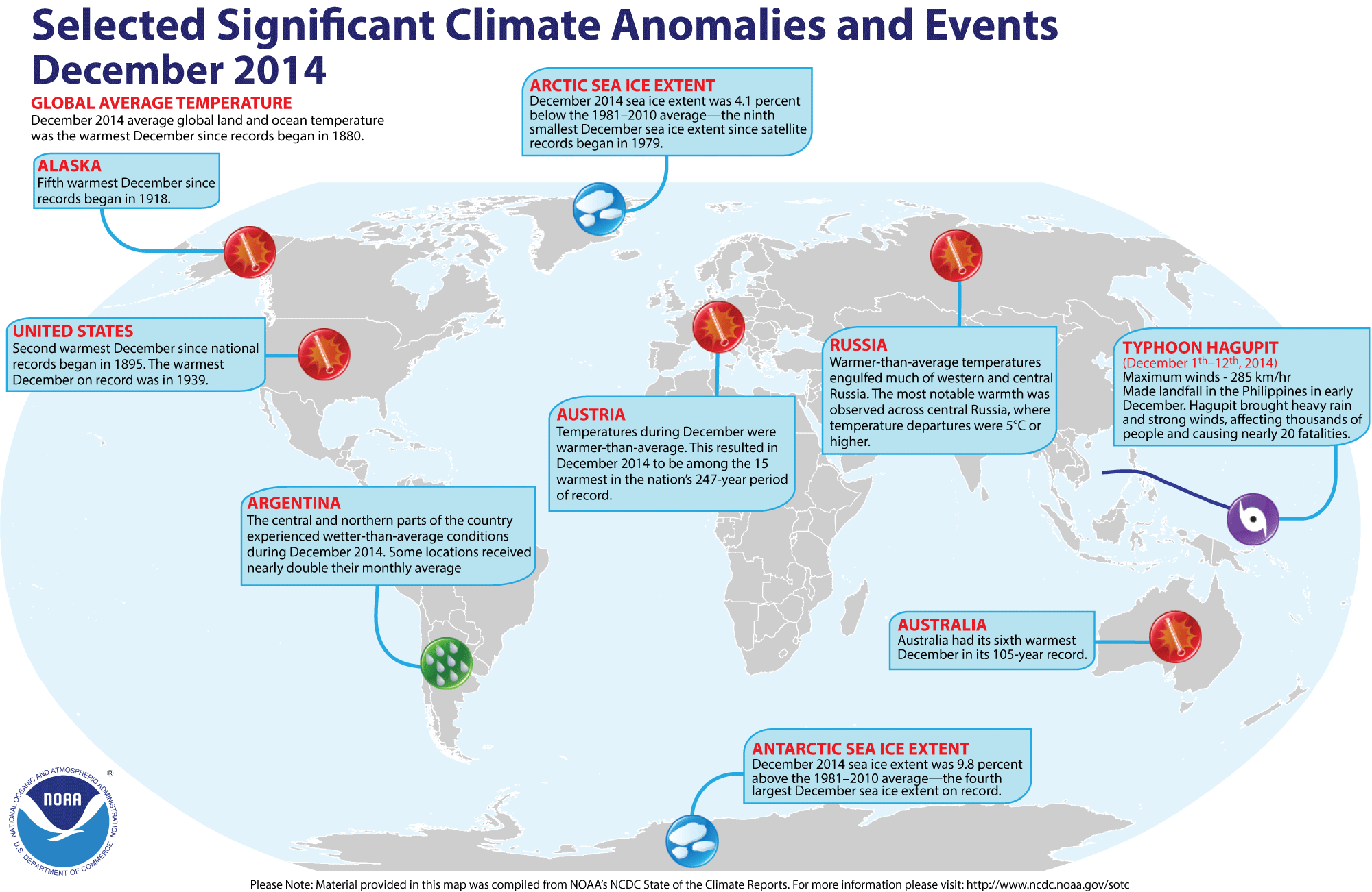
Click here for the full report. Click here to go to the National Climatic Data Center website. Here’s an excerpt:
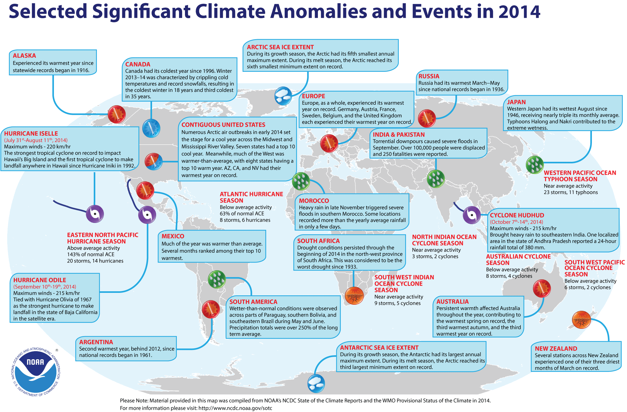
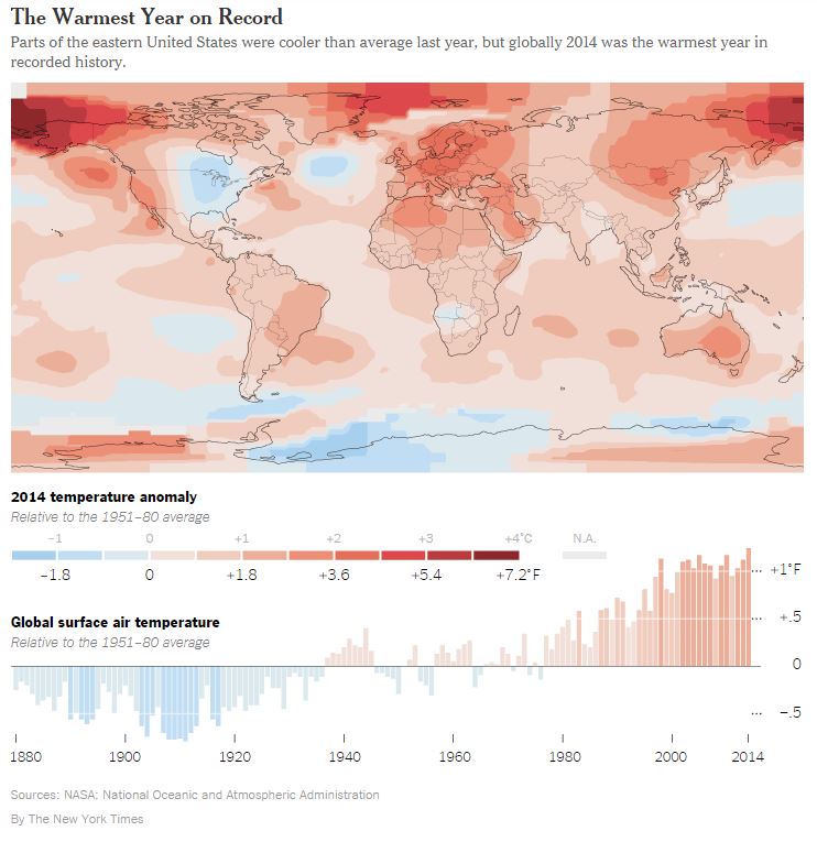
The globally averaged temperature over land and ocean surfaces for 2014 was the highest among all years since record keeping began in 1880. The December combined global land and ocean average surface temperature was also the highest on record.
Global highlights: Calendar Year 2014
During 2014, the average temperature across global land and ocean surfaces was 1.24°F (0.69°C) above the 20th century average. This was the highest among all 135 years in the 1880–2014 record, surpassing the previous records of 2005 and 2010 by 0.07°F (0.04°C).
Record warmth was spread around the world, including Far East Russia into western Alaska, the western United States, parts of interior South America, most of Europe stretching into northern Africa, parts of eastern and western coastal Australia, much of the northeastern Pacific around the Gulf of Alaska, the central to western equatorial Pacific, large swaths of northwestern and southeastern Atlantic, most of the Norwegian Sea, and parts of the central to southern Indian Ocean.
During 2014, the globally-averaged land surface temperature was 1.80°F (1.00°C) above the 20th century average. This was the fourth highest among all years in the 1880–2014 record.
During 2014, the globally-averaged sea surface temperature was 1.03°F (0.57°C) above the 20th century average. This was the highest among all years in the 1880–2014 record, surpassing the previous records of 1998 and 2003 by 0.09°F (0.05°C).
Looking above Earth’s surface at certain layers of the atmosphere, two different analyses examined NOAA satellite-based data records for the lower and middle troposphere and the lower stratosphere.
The 2014 temperature for the lower troposphere (roughly the lowest five miles of the atmosphere) was third highest in the 1979-2014 record, at 0.50°F (0.28°C) above the 1981–2010 average, as analyzed by the University of Alabama Huntsville (UAH), and sixth highest on record, at 0.29°F (0.16°C) above the 1981–2010 average, as analyzed by Remote Sensing Systems (RSS).
The 2014 temperature for the mid-troposphere (roughly two miles to six miles above the surface) was third highest in the 1979–2014 record, at 0.32°F (0.18°C) above the 1981–2010 average, as analyzed by UAH, and sixth highest on record, at 0.25°F (0.14°C) above the 1981–2010 average, as analyzed by RSS.
The temperature for the lower stratosphere (roughly 10 miles to 13 miles above the surface) was 13th lowest in the 1979–2014 record, at 0.56°F (0.31°C) below the 1981–2010 average, as analyzed by UAH, and also 13th lowest on record, at 0.41°F (0.23°C) below the 1981–2010 average, as analyzed by RSS. The stratospheric temperature is decreasing on average while the lower and middle troposphere temperatures are increasing on average, consistent with expectations in a greenhouse-warmed world.
According to data from NOAA analyzed by the Rutgers Global Snow Lab, the average annual Northern Hemisphere snow cover extent during 2014 was 24.95 million square miles, and near the middle of the historical record. The first half of 2014 saw generally below-normal snow cover extent, with above-average coverage later in the year.
Recent polar sea ice extent trends continued in 2014. The average annual sea ice extent in the Arctic was 10.99 million square miles, the sixth smallest annual value of the 36-year period of record. The annual Antarctic sea ice extent was record large for the second consecutive year, at 13.08 million square miles.
Global highlights: December 2014
During December, the average temperature across global land and ocean surfaces was 1.39°F (0.77°C) above the 20th century average. This was the highest for December in the 1880–2014 record, surpassing the previous record of 2006 by 0.04°F (0.02°C).
During December, the globally-averaged land surface temperature was 2.45°F (1.36°C) above the 20th century average. This was the third highest for December in the 1880–2014 record.
During December, the globally-averaged sea surface temperature was 0.99°F (0.55°C) above the 20th century average. This was also the third highest for December in the 1880–2014 record.
The average Arctic sea ice extent for December was 210,000 square miles (4.1 percent) below the 1981–2010 average. This was the ninth smallest December extent since records began in 1979, according to analysis by the National Snow and Ice Data Center based on data from NOAA and NASA.
Antarctic sea ice during December was 430,000 square miles (9.9 percent) above the 1981–2010 average. This was the fourth largest December Antarctic sea ice extent on record.
According to data from NOAA analyzed by the Rutgers Global Snow Lab, the Northern Hemisphere snow cover extent during December was 130,000 square miles below the 1981-2010. This was the 20th smallest December Northern Hemisphere snow cover extent in the 49-year period of record.
Several scientists said the most remarkable thing about the 2014 record was that it occurred in a year that did not feature El Niño, a large-scale weather pattern in which the ocean dumps an enormous amount of heat into the atmosphere.
Longstanding claims by climate-change skeptics that global warming has stopped, seized on by politicians in Washington to justify inaction on emissions, depend on a particular starting year: 1998, when an unusually powerful El Niño produced the hottest year of the 20th century.
With the continued heating of the atmosphere and the surface of the ocean, 1998 is now being surpassed every four or five years, with 2014 being the first time that has happened in a year featuring no real El Niño pattern. Gavin A. Schmidt, head of NASA’s Goddard Institute for Space Studies in Manhattan, said the next time a strong El Niño occurs, it is likely to blow away all temperature records…
“Obviously, a single year, even if it is a record, cannot tell us much about climate trends,” said Stefan Rahmstorf, head of earth system analysis at the Potsdam Institute for Climate Impact Research in Germany. “However, the fact that the warmest years on record are 2014, 2010 and 2005 clearly indicates that global warming has not ‘stopped in 1998,’ as some like to falsely claim.”
Such claims are unlikely to go away, though. John R. Christy, an atmospheric scientist at the University of Alabama in Huntsville who is known for his skepticism about the seriousness of global warming, pointed out in an interview that 2014 had surpassed the other record-warm years by only a few hundredths of a degree, well within the error margin of global temperature measurements.
Continue reading the main storyContinue reading the main storyContinue reading the main story
“Since the end of the 20th century, the temperature hasn’t done much,” Dr. Christy said. “It’s on this kind of warmish plateau.”
NASA and the other American agency that maintains long-term temperature records, the National Oceanic and Atmospheric Administration, issued separate data compilations on Friday that confirmed the 2014 record. A Japanese agency had released preliminary information in early January showing 2014 as the warmest year.
The last scientific group that curates the world’s temperature record, in Britain, is scheduled to report in the coming weeks.
“Why do we keep getting so many record-warm years?” Dr. Schmidt asked in an interview. “It’s because the planet is warming. The basic issue is the long-term trend, and it is not going away.”
February 1985 was the last time global temperatures fell below the 20th-century average for a given month, meaning that no one younger than 30 has ever lived through a below-average month.
The contiguous United States set its temperature record in 2012. But, mainly because of the unusual chill in the East last year, 2014 was only the 34th warmest year on record for the lower 48 states.
That cold was brought into the interior of the country by a loop in a current called the jet stream that allowed Arctic air to spill southward. But an offsetting kink allowed unusually warm tropical air to settle over the West, large parts of Alaska and much of the Arctic.
A few recent scientific papers say that such long-lasting kinks in the jet stream have become more likely because global warming is rapidly melting the sea ice in the Arctic, disturbing longstanding weather patterns. But many leading scientists are not convinced on that point.
A controversial bill that failed to find its way into law last year has resurfaced in the state Legislature.
The bill is an attempt to create a flex water right that would allow agricultural water to be applied to other uses for up to five years in 10. The bill has been adjusted to prevent it from being used to move water anywhere, anytime for any use, as the first versions allowed. [ed. emphasis mine]
[HB15-1038, Flexible Water Markets], sponsored by state Rep. Jeni Arndt, D-Fort Collins, would allow a more flexible water right that requires continued irrigation of farmland, identifies end users and includes continued court review as a condition. It also prevents water from being transferred from one basin to another. [ed. emphasis mine]
The bill would allow a water judge to determine conditions that determine continued irrigation.
It would allow up to 50 percent of the consumptive use — that part of water used to grow crops — over a 10-year period to be used for things such as municipal supplies, recreation, environment or compact compliance.
Some changes in the bill are an attempt to comply with the state’s anti-speculation doctrine as outlined to the interim water resources review committee in September by Justice Greg Hobbs.
Among recent Supreme Court decisions prohibiting speculative use is the 2005 decision to uphold Pueblo District Judge Dennis Maes’ 2003 decision to deny an application on the Fort Lyon Canal by High Plains A&M that would have allowed wide-scale water marketing.
A second measure, [SB15-008, Promote Water Conservation In Land Use Planning], sponsored by state Sen. Ellen Roberts, R-Durango, and state Rep. Ed Vigil, D-Fort Garland, would attempt to tie water conservation with land-use planning through state water funding programs.
It passed the Senate ag committee on a 5-4 vote.
The bill came out of the interim water resources committee with provisions and a proposed amendment by Roberts that would make conservation training mandatory for water officials and land use planners. It would apply to water providers that supply more than 2,000 acre-feet of water annually.
That bill is already getting pushback from municipal water providers, who are offering alternative language that allows for more time to develop conservation plans and gives them credit for quantifiable conservation programs in the past.
Click on a thumbnail graphic above to view a gallery of drought data from the US Drought Monitor. Click here to go to the website. Here’s an excerpt:
Summary
The week was relatively dry nationwide, with the High Plains separating generally warmer-than-normal conditions to the west from colder weather farther east. Precipitation totals exceeding an inch were common in a few regions; specifically, parts of New Jersey and Delaware, the Carolinas, the Florida Peninsula and adjacent southeastern Georgia, central and eastern Tennessee and adjacent Alabama, eastern Texas and parts of central and western Louisiana, southwestern California, portions of the Aleutians and coastal southern Alaska, and the Alaskan Panhandle. Heavy amounts exceeding 5 inches, however, were limited to a couple of isolated sites on Kodiak Island and in the southernmost Alaskan Panhandle…
California
Light to moderate precipitation fell on southern parts of the state away from the deserts, with amounts exceeding an inch common along the southwest coastline and the adjacent windward slopes. Little or none fell elsewhere.
Benefits from last month’s storms continue to be felt in west-central California, prompting improvements to D2 in Marin, adjacent Sonoma, San Francisco, and northernmost San Mateo Counties.
Farther east, improvement has not been as resilient in much of the Sacramento Valley, and following a month of subnormal precipitation, D4 has been brought back into part of the Sacramento Valley from Sacramento, Yolo, and western El Dorado Counties northward through Butte County. Reservoirs near and north of this region are still above their levels at the start of the current wet season, but water-year-to-date totals have dropped back to near average and 24-month precipitation totals are among the lowest 2 to 10 percent of historical occurrences.
Along and east of the central and southern Sierra Nevada, D4 was expanded eastward past the ridge line to include the eastern slopes of the range from Inyo County, California northward through Douglas County, Nevada. Subnormal winter precipitation has combined with abnormal warmth to leave Sierra Nevada snowpack well short of the historic mid-January average in central and southern parts of the range. Since October 1, 2014, precipitation totals are 3 inches to locally over a foot below normal from the slopes of eastern Fresno and adjacent Inyo Counties northward through eastern Nevada County…
Central and Southern Plains
Moderate to locally heavy precipitation prompted patchy improvement across southern and eastern Texas, but it was a cold and dry week elsewhere, keeping dryness and drought predominantly unchanged. Some deterioration was noted in a few spots in northern Texas, including some D4 expansion into Hardeman and Foard Counties just southeast of the Panhandle. Precipitation since October 2014 has totaled less than 75 percent of normal across much of the Panhandle and in adjacent areas to the east, and 6-month totals below half of normal were noted in a few small areas in southwestern Oklahoma and the central Texas Panhandle…
Northern Plains and upper Midwest
A very cold and dry week kept conditions locked as they were the previous week, with broad-scale abnormal dryness and a smaller area of moderate drought…
The Pacific Northwest
Little precipitation of significance fell last week, but some adjustments were made based on a re-assessment of information. So far, winter has not been markedly wet or dry in general across the Cascades, but it has been warmer than normal, and snowpack is low for this time of year. As a result, D0 conditions were expanded to cover the Oregon Cascades, and the ridge line and eastern slopes of the Cascades in central and southern Washington. In contrast, D1 was retracted from the southwest Oregon coastal region, and reports of lessening impacts led to improvements in the D0 to D2 conditions across central and eastern Washington and adjacent Idaho…
The Southern Rockies and Eastern Intermountain West
From central sections of Idaho and Nevada eastward across the Four Corners states and small portions of southern Wyoming and southwestern Montana, no changes were made to the analysis. South and west of the central Rockies, D0 to D2 conditions prevail, with spots of D3 in southern Idaho, southeastern Arizona, and along the northern Arizona/New Mexico border. Precipitation totals exceeding an inch were confined to isolated locales in the highest elevations…
Looking Ahead
The upcoming 5-day period (January 14 – 18, 2015) looks generally mild and dry across the contiguous 48 states. According to the Weather Prediction Center, heavy precipitation (2 to 7 inches) should be limited to northwest California and the Pacific Northwest along and west of the Cascades, with the largest amounts expected along parts of the immediate coastline and windward mountain slopes. Moderate to locally heavy precipitation (1.5 to 3.0 inches) is expected in parts of central and northern Idaho. Elsewhere, amounts of 0.5 to 1.5 inches are forecast across the remainders of northern California, the Pacific Northwest, and Idaho, plus adjacent portions of western Montana and northwestern Wyoming. Farther south and east, totals above 0.5 inch should be limited to New England, the Outer Banks, and the immediate central Gulf Coast. The rest of the East Coast, southern sections of the central Gulf Coast states, and the upper Great Lakes regions are expected to receive light precipitation, with little or none anticipated elsewhere. Temperatures should average at least somewhat above normal from the Mississippi Valley westward, with daily highs averaging 9oF to 18oF above normal from south-central sections of the Plains and Front Range northward to the Canadian border.
For the ensuing 5 days (January 19 – 23, 2015), warmer than normal weather is favored across almost all of the 49 continental states, except northwestern Alaska and parts of the central and northern High Plains and adjacent Rockies. Subnormal precipitation is anticipated throughout the West Coast states, western Arizona, and most of Nevada while surplus precipitation is expected from the eastern edge of the Rockies eastward through the Great Lakes region, the middle Ohio Valley, and the central Gulf Coast region. Wet weather is also favored throughout Alaska.
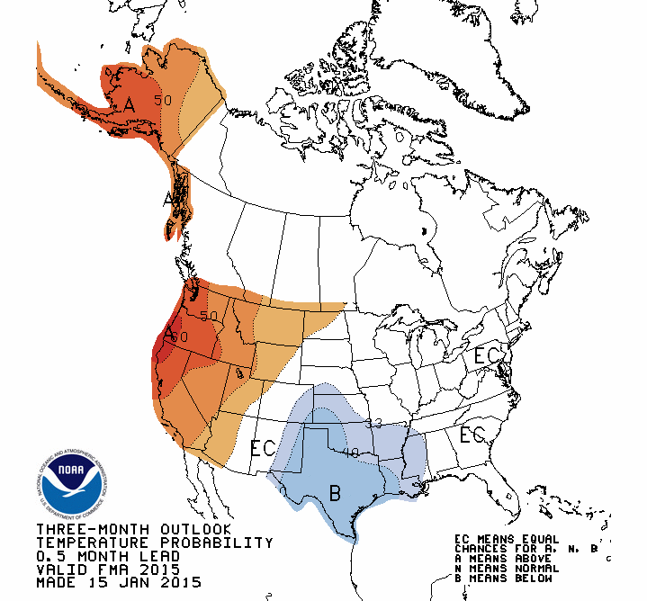
Meanwhile the Climate Prediction Center issued their seasonal outlook for drought, precipitation, and temperature yesterday:
Seasonal Drought Outlook January 15 thru April 30, 2015 via the Climate Prediction CenterPrecipitation Outlook January 15 thru April 30, 2015 via the Climate Prediction CenterTemperature Outlook January 15 thru April 30, 2015 via the Climate Prediction Center
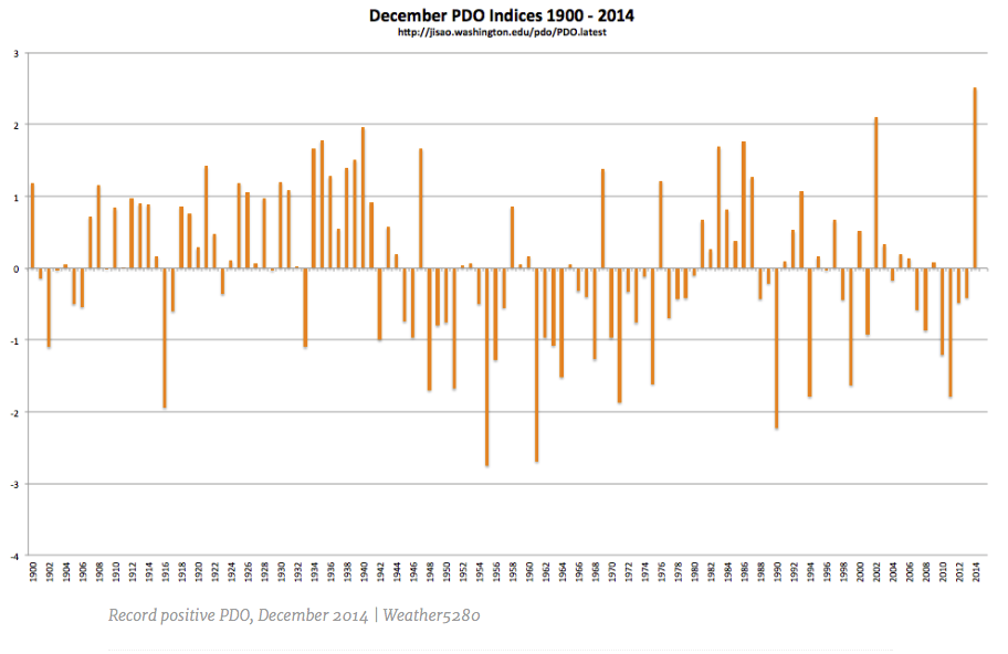
The Pacific Decadal Oscillation (PDO) index broke the record for highest positive ever recorded during the month of December in 2014. At 2.51, this is also the highest value since August of 1997 according to NWS Albuquerque. Below is a chart of all December PDO indices since 1900, this past one well above any other (far right).
December Pacific Decadal Oscillation indices 1900 thru 2014 via Weather5280.com
Upper South Platte Basin
Here’s the abstract (click through to read the report) from the United States Geological Survey:
During May–June, 2013, the U.S. Geological Survey, in cooperation with Park County, Colorado, drilled and installed four groundwater monitoring wells in areas identified as needing new wells to provide adequate spatial coverage for monitoring water quality in the South Park basin. Lithologic logs and well-construction reports were prepared for each well, and wells were developed after drilling to remove mud and foreign material to provide for good hydraulic connection between the well and aquifer. Slug tests were performed to estimate hydraulic-conductivity values for aquifer materials in the screened interval of each well, and groundwater samples were collected from each well for analysis of major inorganic constituents, trace metals, nutrients, dissolved organic carbon, volatile organic compounds, ethane, methane, and radon. Documentation of lithologic logs, well construction, well development, slug testing, and groundwater sampling are presented in this report.
Similar to last year but not quite as good the moisture situation in the northern part of the Rio Grande Basin is better than in the southern end.
The current storm moved in from the south, however, so local forecasters were hopeful the southern part of the Valley would receive some moisture.
“We are below where we were last year,” Colorado Water Division 3 Assistant Division Engineer James Heath told attendees of the Rio Grande Roundtable meeting yesterday in Alamosa. “We didn’t get the early snow like we did last year.”
Heath said last year stream flows in Saguache Creek in the northern part of the basin ran better than average, the Rio Grande at Del Norte right at average and the Conejos River at Mogote 80 percent of average.
“We are in that same boat again this year,” he said.
Once again, the northern part of the basin seems to be receiving more moisture than the southern end, he explained.
Heath said the Natural Resources Conservation Service (NRCS) has released its first stream flow forecast for 2015, predicting 78 percent of average on the Rio Grande at Del Norte, 109 percent on Saguache Creek and 66 percent on the Conejos River.
“We are following in the same pattern as last year,” he said. “Hopefully we get some more storms.”
He said the National Oceanic and Atmospheric Administration is predicting higher than average precipitation for this region for the next three months, so he is hoping that turns out to be true.
When Roundtable member Travis Smith said, “you have to be very optimistic. You have some room for improvement ,” Heath said, “We have had 20 years of drought ” It can only get better from here.”
Smith said, “We are ever hopeful it’s going to be better .”
As of Tuesday, the Rio Grande Basin had the lowest snowpack in the state, according to NRCS snow measurement data. This basin stood at about 65 percent of average snowpack overall, with “runner up” lowest in the state being the San Miguel, Dolores, Animas and San Juan River Basins sitting at 73 percent of normal. All the other river basins in the state were either slightly under or over average snowpack on Tuesday, with the highest being the Arkansas and South Platte River Basins at 106 percent of average.
Colorado met its Rio Grande Compact obligations to downstream states in 2014, and the state engineer advisors are currently finalizing compact data. Conejos Water Conservancy District Manager Nathan Coombs is involved in a project to improve stream flow forecasting, particularly on the Conejos. He said meeting the compact obligation in 2014 was a significant task for water users on the Conejos River system where the initial forecast was off, so water users wound up owing a greater percentage of water during the irrigation season.
“We came out on the compact, but what it took was significant. It took 90 days of number-one’s being curtailed or shut off. It takes a lot to make that work,” Coombs said.
In better news, Rio Grande Water Conservation District General Manager Steve Vandiver reported yesterday the water reduction efforts of the water district’s first sub-district are making a difference in the basin’s aquifer. The unconfined aquifer storage, which has been measured since 1976 and has declined more than a million acre feet since that time, has recovered about 60,000 acre feet from its lowest point and is about 45,000 acre feet ahead of where it was last year, Vandiver said.
He added pumping over the last three years has decreased about 30 percent.
“There’s been significant savings and reduction of pumping, unlike some areas of the state where pumping actually increased,” Vandiver said.
“Mother Nature” needs to step up too, however, Vandiver explained. He said under current conditions it looks like it takes about 600,000 acre feet annual flow or above on the Rio Grande to make any significant gain.
“There has to be that level of diversion to support the well pumping that’s currently going on.”
The NRCS late-season forecasts for the Rio Grande in 2014 were 640,000 acre feet annual flow , or close to the long-term average.
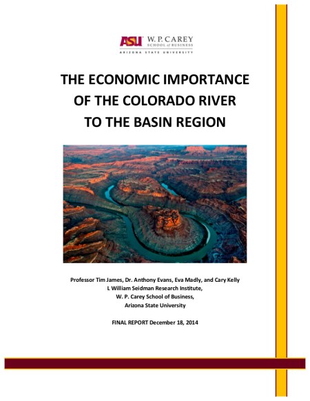
A first-ever comprehensive report by noted economist Tim James at W.P. Carey School of Business at Arizona State University, commissioned by business coalition Protect the Flows, identifies the economic value and number of jobs dependent on the river for all the basin states and major economic sectors that use water from the river.
The study reveals that hanging in the balance of the health of the Colorado River system are more than $1.4 trillion in economic activity, $871 billion in wages, and 16 million jobs. Put into perspective, an estimated 64.4 percent of the combined value of each basin state’s output of goods and services – could be lost if Colorado River water is no longer available to residents, businesses, industry, and agriculture. Read the Executive Summary here.
A new study for the first time quantifies the economic importance of Colorado River water to seven Western states—and the dire outcome should ongoing droughts dry up even a portion of it.
The river’s water fuels $1.4 trillion in annual economic activity in California, Arizona, Nevada, Utah, Colorado, New Mexico and Wyoming, says the research by economists at Arizona State University. With just a 10% reduction in the water available for human use the gross economic product of those states would fall by $143 billion and cost 1.6 million jobs.
At a 20% drop, those numbers would shoot up to $287 billion in lost economic activity and 3.2 million jobs, according to the study.
The study assumes that no increase in water from other sources would be available. Those states, all of which have contractual rights to water from the Colorado, so far have managed to largely offset reductions in river flow brought on by a 15-year drought by drawing from underground reserves and stepping up conservation, among other measures.
The researchers warn that real economic pain could occur when shortfalls no longer can be made up as population continues to grow and climate change affects rainfall.
“We are getting to the crunch now,” said Timothy James, an Arizona State economics professor who led the study. “The Colorado River is the lifeblood of the entire region.”
California’s drought, for example, has forced municipalities to draw so much more water from underground that some wells have gone dry. The state relies on the Colorado River, along with the snowpack in the Sierra Nevada, to meet much of its water needs.
The river’s troubles are well documented elsewhere. The water level at Lake Mead—the largest reservoir for the Colorado River—has fallen more than 100 feet over the past decade to an elevation of 1,089 this week, according to Bureau of Reclamation figures.
So far, the declining flows haven’t significantly affected the region’s economy, though farmers have suffered cutbacks and boating and other river-related businesses have taken a hit.
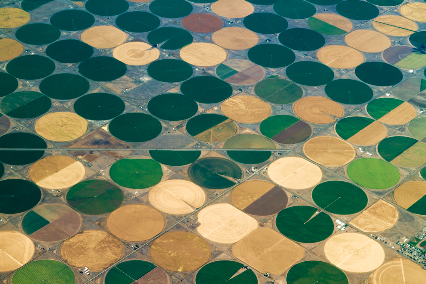
Crop circles — irrigated agriculture Click here to read the latest newsletter from the Colorado Foundation for Water Education. Here’s an excerpt:
The Efficiency Dilemma
Colorado today dedicates a whopping 89 percent of the water it uses to agriculture. That water is diverted into ditches and reservoirs to sate farm fields and pasture lands that, in turn, feed cattle and other livestock—and, of course, people. As agricultural water right owners face increasing pressure and competition from cities, efforts are underway to improve the efficiency of irrigation methods and keep Colorado ag viable. Through rapidly advancing technologies, producers are finding ways to stretch a limited resource, while at the same time accomplishing other goals, such as improving water quality, achieving labor savings and, often times, increasing the productivity of the land. It’s complicated, however, as efficiency comes at a cost, both financially and through changes to whole systems that have grown to rely on agricultural return flows—flows that diminish as upstream farmers grow more efficient.
Learn about the experiences of those who are forging ahead in “The Efficiency Dilemma,” covered in Headwaters Fall 2014 issue, which focused on the Eastern Plains region. Find the article here.
More Colorado Foundation for Water Education coverage here.
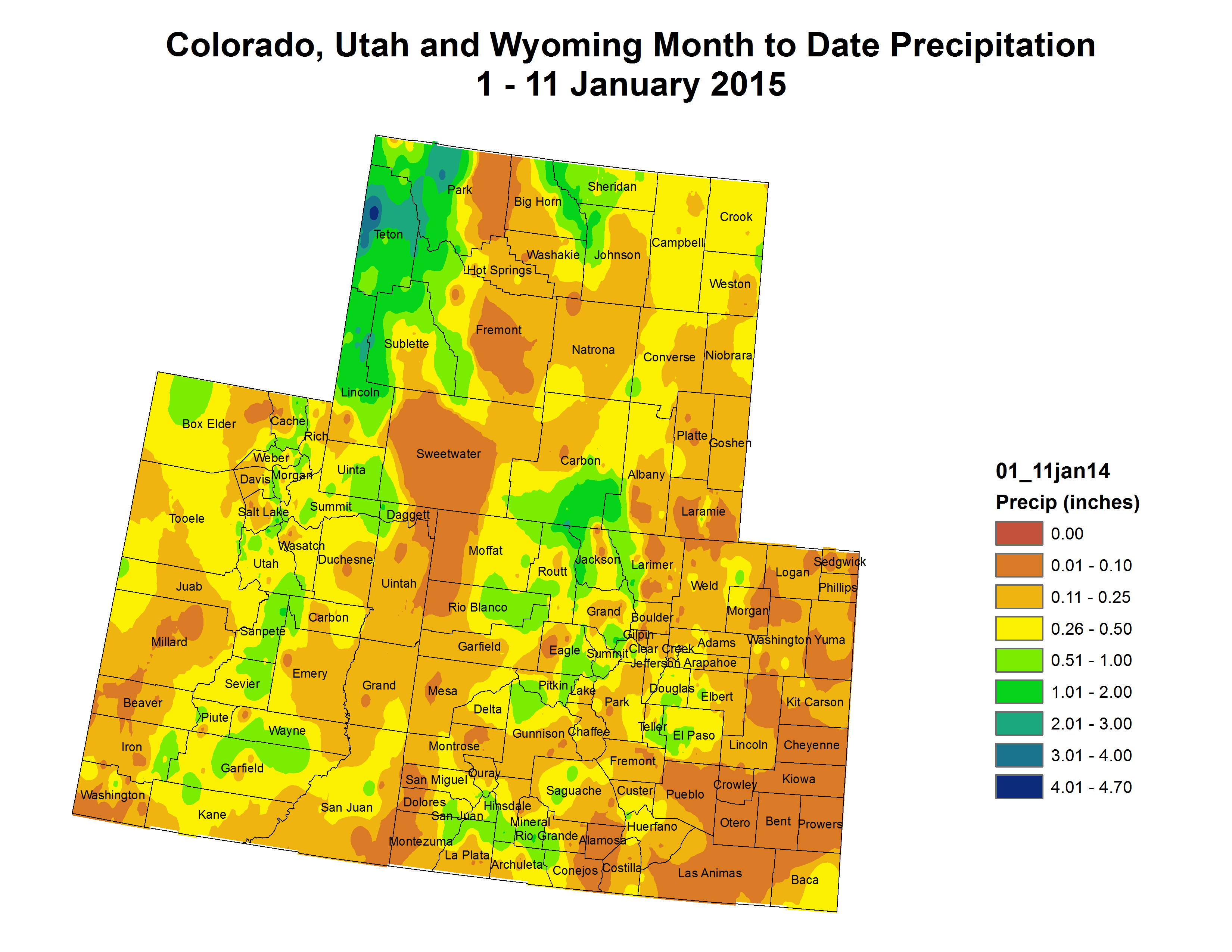
Upper Colorado River Basin precipitation to date January 1 thru 15, 2015 via the Colorado Climate Center
Click here to read the current assessment. Click here to go to the NIDIS website hosted by the Colorado Climate Center. Here’s an excerpt:
Water Year 2015 Precipitation:
Three months into the water year, much of the higher terrain of the UCRB is at or above normal precipitation.
The Upper Green River basin in Sublette, Lincoln and Uinta counties are above normal, while much of Sweetwater County is drier, receiving less than 90% of normal for the Water Year to date.
The Uintah Range in Utah are drier, reporting less than 90% of normal, with much of the southern side of the range less than 70% of normal.
The southern portion of the basin is drier, with much of the lower elevations seeing less than 70% of normal precipitation for the water year to date.
The San Juan Mountains and headwaters of the Gunnison River are at or above normal.
The Rio Grande basin is showing better percent of normal, with the higher elevations surrounding the San Louis Valley at or above normal. The Valley is drier, but still near normal (70% and above).
East of the divide in Colorado, the eastern plains recovered nicely in December, now reporting at or above normal precipitation for the water year. Portions of Weld, Washington, Phillips and Yuma counties are slightly drier, with areas between 70% – 90% of normal.
Portions of Otero, Crowley, Bent and Las Animas counties, where drought has been the worst, have seen better than 150% of normal for the water year to date.
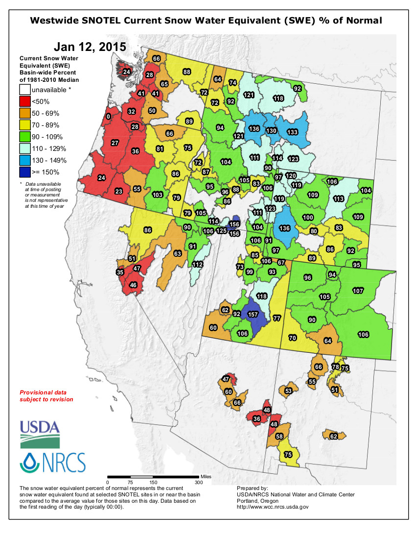
Westwide SNOTEL snow water equivalent as a percent of normal January 12, 2015
Click here to go to the Western Water Assessment website. Here’s an excerpt:
Highlights
December brought above-average statewide precipitation to Wyoming, Colorado, and Utah, with most mountain areas seeing wettter-than-normal conditions.
The snowpack has generally improved in the last month, with the majority of the region’s basins now reporting above-median SWE. Basins in southwestern Colorado, as well as southwestern and eastern Utah, remain near or below 75% of median SWE.
The first spring-summer runoff forecasts for the 2015 season indicate mixed prospects for the region’s basins, with mainly normal to above-normal runoff expected in Wyoming and northern and central Colorado, and below-normal to normal runoff for Utah and southern Colorado.
The tropical Pacific continues to experience “El Limbo” conditions, though the eventual emergence of a full-blown El Niño event is still expected by most forecast models.
Here’s the release from the Bureau of Reclamation (Peter Soeth):
The Bureau of Reclamation is providing a funding opportunity for communities in the West which may be seeking new sources of water supplies using water recycling and reuse technologies. Funding made available will assist communities in determining whether water recycling and reuse projects are feasible. This funding opportunity is part of the Department of the Interior’s WaterSMART initiative, which focuses on improving water conservation, sustainability and helping water resource managers make sound decisions about water use.
The Title XVI Water Reclamation and Reuse Feasibility Study Funding Opportunity Announcement is available at http://www.grants.gov by searching for funding opportunity number R15AS00015. It is estimated that $1.3 million may be awarded this year.
Funding will be available in two funding groups. In the first funding group, up to $150,000 in federal funds will be available for smaller feasibility studies which can be completed in 18 months. For the second funding group – including larger feasibility studies which can be completed in 36 months – up to $450,000 in federal funds will be available. It is expected that most of the awards will be made in the first category. Feasibility studies are funded jointly by Reclamation and project sponsors. A cost-share of at least 50-percent of study costs is required.
The studies focus on examining municipal water reclamation and reuse, industrial domestic or agricultural wastewater, and naturally impaired groundwater and/or surface waters. Reclaimed water can be used for a variety of purposes such as environmental restoration, fish and wildlife and groundwater recharge, including municipal, domestic, industrial, agricultural, power generation or recreational use. Water reclamation and reuse is an essential tool in stretching the limited water supplies in the West. Since 1992, approximately $600 million in federal funding through the WaterSMART Title XVI Program has been leveraged with non-federal funding to implement more than $3 billion in water reuse improvements.
Funding applications are due on March 3, 2015, at 4:00 p.m. Mountain Standard Time. To learn more about the Title XVI Program, please visit http://www.usbr.gov/WaterSMART/title.
From the Loveland Reporter-Herald (Pamela Johnson):
The plan for the South Platte Basin, which covers all of Northern Colorado including tributary Big Thompson River, was discussed Tuesday at a public meeting in Loveland.
Members of the roundtable asked for public input on their plan to protect and balance all the interests in Colorado water within the law and the water rights structure.
The plan so far calls for creating new, multiuse projects that pull water from diverse sources, expanding conservation and reuse of water, exploring the use of groundwater and aquifer storage and stopping the old practice of “buy and dry” up agricultural water and land.
Livermore resident Zach Thode urged the board to delve beyond what they have already studied and, through a regional innovation group, offered to help.
“We have to come up with new ideas, or we will always end up in the same place,” said Thode. “I don’t see anything new and exciting in here. I don’t think this is steering us away from the path that we were already on. I encourage you to look at innovation.”
Eastern Colorado resident Gene Kammerzell offered one suggestion for a new path: Make sure landscapers adequately prepare soil before installing trees, grasses and plants. This simple act, said the man who serves on a groundwater coalition, could cut municipal water use by 20 percent.
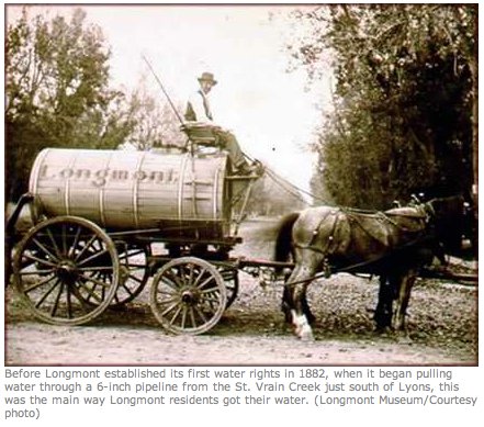
Members of the roundtable encourage additional public comment before the final plan in completed by April 17. More information on the plan, future public meetings and how to comment is available online at http://www.southplattebasin.com.
The city council also voted unanimously to pass an ordinance raising water rates with discussion asking the public to understand the decision.
Bagley said he received a couple of phone calls from concerned senior citizens of Longmont about raising the water rates and asked Barb McGrane from the city’s public works department for information about reduced rates for seniors.
McGrane replied that there is already a measure in place to help senior citizens with their water bill. Someone who qualifies for a certain tax or rental relief is eligible for the partial refund of their water bill as long as the application for the refund is made between Jan. 1 and April 15. More information for senior citizens is available at 303-774-4429.
Council Member Polly Christensen said she hopes the public realizes that with the rising cost of providing water, raising rates is a necessity.
“This is not just fun money,” Christensen said. “No one likes to raise taxes…but we have to fix pipes from 1970.”
Water rates in Longmont are proposed to rise an average of 9 percent a year and the rate structure collapsed from a five-tier plan to four tiers.
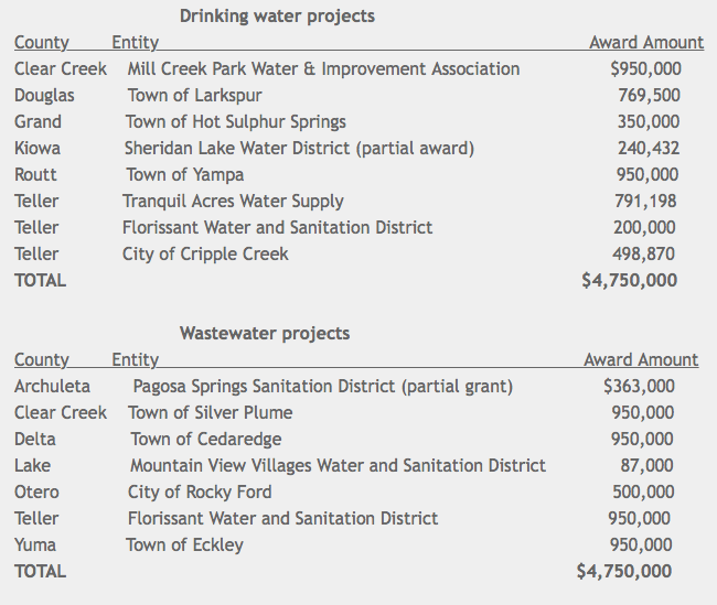
Here’s the release from the Colorado Department of Health and Environment (Mark Salley):
Fifteen community drinking water and wastewater systems in small communities throughout Colorado will receive a total of $9.5 million to fund planning, design or construction of public water systems or treatment works necessary for the protection of public health and water quality.
Funding for the grants was provided by the state Legislature under Senate Bill 09-165 and SB14-025. Governmental agencies, nonprofit public water systems and counties representing unincorporated areas of fewer than 5,000 people were eligible to apply for grants of up to $950,000.
This list is subject to change based on contract negotiations. In the event a recipient cannot accept the grant in whole or part, the available funds will be distributed per the request for application and the small community grant program rules, Regulation No. 55.
Four projects in Teller County intended to improve water quality and wastewater treatment have received a hefty financial boost from oil and gas tax revenues. Colorado water officials recently awarded $9.5 million for 15 grants to small communities across the state – nearly $2.7 million of which will be spent in Teller County.
The money will go toward a mix of projects, including upgrades that could increase water capacity for one subdivision, and improvements that could assuage water quality concerns by some state regulators.
The state fielded 80 applications, making the grants very competitive.
“It was a very popular program this year,” said Tawnya Reitz, a project manager for the Colorado Water Quality Control Division’s grants and loans unit.
Tranquil Acres Water Supply, which serves a subdivision near Woodland Park, received $791,198 to upgrade its 1950s-era water infrastructure. It plans to re-drill wells, install new pumps and build a 100,000-gallon storage tank that could help alleviate water capacity issues, Reitz said.
The state awarded $498,870 to help finance water treatment upgrades so the City of Cripple Creek can meet new chlorine residual standards, she said.
The Florissant Water and Sanitation District received two grants, one for a drinking water project and another to better treat wastewater.
A $200,000 grant will help pay for the installation of a new filtration system, Reitz said.
A $950,000 grant is expected to partially finance new pond liners and a sequencing batch reactor for wastewater treatment, she said.
More water treatment coverage here. More wastewater coverage here.
The Upper Colorado River Basin — that’s us — is running 14 percent ahead of normal, as are the Yampa and White River Basin, and the South Platte River Basin, the NRCS said…
Besides the Colorado River Basin at 114 percent of median, the Gunnison Basin is 99 percent of median and the South Platte Basin is 112 percent of median.
Statewide reservoir storage is in good shape; end-of-December storage totals were at 103 percent of average, Domonkos said.
However, November brought cooler temperatures and snow to the mountains. The moisture stopped before Thanksgiving and the state experienced an unusual lack of moisture for more than two weeks, Domonkos said.
The normal is based on the 30-year average between 1980-2010, said Diane Johnson with the Eagle River Water & Sanitation District. That norm will be adjusted in 2020 for the next 30-year cycle between 1990-2020.
“Snowpack is all about good conditions on the hill, good conditions in the rivers and a good water supply,” Johnson said.
Johnson tends to be cautious, and while she’s encouraged by the early season snowpack, she said a great deal can happen between now and April, or worse, nothing can happen…
Unfortunately not all of the major basins in Colorado are reporting normal snowpack conditions.
The Upper Rio Grande and San Juan, Animas, Dolores and San Miguel basins are reporting totals of just 71 and 75 percent of median respectively, according to the NRCS.
That’s not great news for these areas that have not recorded a normal seasonal snowpack since 2010, Domonkos said.
“If these basins don’t receive increased precipitation over the next few months, they may be looking at their fifth consecutive year of below normal snowpack and seasonal streamflow runoff,” Domonkos said.
After a dry start to the season, recent storms have brought Colorado’s snowpack up to near normal for this time of year – moderately good news for both skiers and water managers. However, the benefits of these storms have not been evenly distributed across the state.
As of Jan. 12, the Colorado, South Platte and Arkansas River Basins all had above-normal amounts of water in the snow piling up in the mountains along the I-70 corridor and the central part of the state. A little farther to the northwest, the Yampa and White River Basins were at 96 percent of normal, while just to the southwest, the Gunnison Basin was at 90 percent. Moving farther south, the river basins in the far southwest corner of Colorado were at 70 percent of normal, and the Rio Grande Basin in south-central Colorado was at just 64 percent of normal.
The Colorado river basins with the skimpiest snowpacks have already been shortchanged for several years in a row. On the U.S. Drought Monitor map, you can see that a lumpy wedge across the southern tier of Colorado is in a long-term drought. The wedge is fatter and shows more severe drought conditions in the Southeast and is skinnier and shows more moderate drought conditions in the Southwest. The Albuquerque Journal recently reported that as a result of multiple dry years, water deliveries to central New Mexico from the San Juan River Basin in southwestern Colorado will be short this year for the first time in the 40-year history of the San Juan – Chama Project.
Region-wide, Colorado is doing better than its neighbors in the Colorado River Basin, with the exception of Wyoming. Most of New Mexico is in some level of long-term drought and an area of extreme drought straddles the Arizona-New Mexico border just south of the Colorado state line. Most of Arizona and Utah are in moderate to severe drought.
Outside of the Colorado River Basin, but also dependent upon Colorado River water, California has seen some improvement in its headline-making drought, although most of the state remains in extreme or exceptional drought – the two worst categories as defined by the U.S. Drought Monitor.
The three-month outlook released by the National Oceanic and Atmospheric Administration (NOAA) on Dec. 31 indicated a likelihood of above-average precipitation for most of Arizona, New Mexico and southern California, with “equal chances” of above or below-average precipitation for Colorado, Utah and Wyoming. Still, the seasonal drought outlook is for the drought in the four corners area to persist or intensify.
To put the current snowpack data in perspective, mid-January is typically about the mid-point for snowpack accumulation in Colorado. The snow content of storms in the remainder of January, February and March could still tip the balance significantly towards a wet or dry water year.
This is part of a series of articles coordinated by the Water Center at Colorado Mesa University in cooperation with the Colorado and Gunnison Basin Roundtables to raise awareness about water needs, uses and policies in our region. To learn more about the basin roundtables and statewide water planning, and to let the roundtables know what you think, go to http://www.coloradomesa.edu/WaterCenter. You can also find the Water Center on Facebook at Facebook.com/WaterCenter.CMU or Twitter at Twitter.com/WaterCenterCMU.
The city of Grand Junction will use the $15,000 it recently received from Great Outdoors Colorado (GOCO) to remove tamarisk and Russian olive from the undeveloped Matchett Park area.
Because the GOCO funds were awarded as part of a Colorado Youth Corps Association program, the city will hire 10 youth ages 14 to 25 to complete the work, which is expected to take two weeks and to begin this spring.
The brush must be removed before moving forward with the master plan for the Indian Wash area, according to city officials.
Mesa County is one of 14 counties throughout the state in which Colorado Youth Corps Association programs will take place this spring and summer.
The projects, which will employ 200 youth from across the state, will enhance Colorado’s trails, parks, open spaces and wildlife habitat.
The overarching goal is to employ youth and young adults to work on critical outdoor recreation and land conservation projects in partnership with local governments and open space agencies.
All projects throughout the state will be completed with GOCO funds, portions of which come from Colorado Lottery proceeds.
For information about the Matchett Park project, call Traci Wieland at 254-3846 or email traciw@gjcity.org.
For information about the youth corps, call Jeff Roberts with the Western Colorado Conservation Corps at 241-1027 or email jroberts@mesapartners.org.
Thousands of miles away from our wintry landscape, it’s a warming of water in the Pacific Ocean known as El Nino– a warming that can have potential impact on our snowfall.
“It’s hard to get a clear reading on it this year,” said Nolan Doesken, the State Climatologist for Colorado.
He says data last summer showed El Nino getting ready to strengthen. A lack of major hurricanes in the Atlantic Ocean last season seemed to back that up. So far, though, it’s remained weak, leaving our winter snowfall in Colorado, average.
“We’ve had big bursts of snow, but it was just enough to get us back up to average, for the state as a whole,” Doesken said.
El Nino can be potentially significant for the state because during strong El Ninos, the state tends to get a lot more snow. Out of the top ten snowstorms ever recorded in Denver, four of them happened in El Nino years, including the infamous Christmas Eve storm of 1982.
“At least, from the past, when you’ve had pretty strong El Nino conditions in the Pacific, it has tended to correlate with some spring storminess on the Eastern Plains and Front Range and some decent mountain snows in spring as well,” Doesken said.
Whether that will happen this spring remains to be seen. NOAA says there is a 50 to 60-percent chance El Nino conditions will emerge in the next two months.
Liz Mock-Murphy expected a little whining from her Greeley Central High School students as she led them outside. Flakes fell from a sky as gray as the icy snow under their feet. The wind fastened a blade to the temperature of just a few puny degrees.
Mock-Murphy winced herself, and she wore a heavy coat and a fuzzy hat with huge earmuffs, the kind used by those who enjoy ice fishing in the mountains. Even Brian Brinkmeier, field supervisor for Quality Well and Pump, wondered how long he could keep his guys, dressed in beefy coats and hats and gloves, outside. They would need breaks in the truck, he said. The students almost looked naked by comparison.
Then Mock-Murphy and her students saw the yellow well tower just a few yards from the entrance. She was pleasantly surprised by their reaction.
“They thought it was really, really exciting,” she said. “I’m not kidding.”
Maybe Mock-Murphy’s students were just used to the cold, given the extended snap that’s blanketed Greeley, or maybe they’re AP environmental science students, so getting to see a water well helped them forget the frostbite. Or maybe, just maybe, they’re excited about applying what they’ve learned to the real world.
The well is part of the Well Watch Project, which hopes to help teachers and students understand the importance of our groundwater through monitoring wells drilled on school properties. The project actually began in 1991 when the Central Colorado Water Conservancy District installed the first well at Eaton Elementary School. By 1995, 16 were added from Eaton to Pueblo. But because there was no way to store and analyze data collected by students, the interest dried up.
The water conservancy district partnered with the Poudre Learning Center to revitalize the project in 2010. Now three wells are at the learning center. One was installed at Platteville Middle School in September, and now there’s the one at Greeley Central. The project teaches students how groundwater occurs, how long it takes to replenish and, perhaps most important, how easily it can be contaminated, as students will monitor for nitrates and the acidity of the water, as well as its oxygen content.
“So they’ll just be able to walk outside, open up a well, drop a line and pull water out of the earth,” Mock-Murphy said.
They can then compare those results with the other wells scattered throughout in the program. Remember how there was no way to store the data in the mid-1990s? The Internet solves that problem now.
Mock-Murphy, like most instructors, prefers to teach this way. She could show them a diagram and talk about a well that delivers water to farmland in Weld, and her AP students would probably get it, but it wouldn’t stick beyond a test. Or she can walk them outside, pull up some water and ask them what could happen if she dumped a bunch of chemicals in it.
“Anytime your students can collect real-time data, they internalize the knowledge,” Mock-Murphy said.
She can, in other words, not only test the water, but also explain that the sand they pull up with it is proof of an ocean that once covered the land.
There’s another reason to help students “internalize” information about groundwater, said Chuck Call, a steward for the Poudre Learning Center who helped put the project together. Most adults don’t realize how important it is to keep groundwater clean, he said. Some rural areas, like those in Weld County, use groundwater for drinking. It’s also a backup to the water in our reservoirs and rivers, and if that water is polluted, Call said, what water would we drink?
“We need an informed public,” Call said. “They will be the ones voting on these issues in the future.”
This isn’t just for an exercise or a test, Mock-Murphy said. The data the kids collect will carry over for years. In fact, that data is one of the reasons Quality Well and Pump donated its equipment and manpower to drill the well at Greeley Central. The company wants to know those numbers, too.
The water conservancy district hopes to expand that collection of data to measure what fracking is doing to the groundwater. There’s no current way for the students to measure that under the parameters of the program, but the district hopes to work with organizations soon to find a way.
That’s one goal. There are other, larger goals. They hope for more wells at more schools, and they will re-drill the ones they lost when the program died in the early ’90s. They will host a second-annual class in the spring to teach more instructors about the project. The goal is to make the water wells part of science instruction throughout Weld County. The groundwater already plays a part in students’ lives. Now they want it to be part of their studies.
Albuquerque’s effort to wean itself from unsustainable groundwater pumping took a major step forward in 2014, with Rio Grande water for the first time in history meeting more than half the needs of the metro area’s largest water utility.
In a year-end report to the state, the Albuquerque Bernalillo County Water Utility reported that 60 percent of its water came from its diversion dam, which intercepts Rio Grande flows near Alameda at the north end of town. Groundwater, pumped from deep layers of sands and gravels beneath the city, made up the other 40 percent of supply. The water utility serves a population of more than 600,000 in Albuquerque and neighboring areas of Bernalillo County.
The shift from groundwater to river water is critical to maintaining the long-term viability of Albuquerque’s water supply, said University of New Mexico water expert Bruce Thomson. “The groundwater is our drought reserve, so we need to preserve that,” Thomson said in an interview Monday.
The shift to river water, bolstered by water imported from the Colorado River Basin via the San Juan-Chama Project, began in 2008. At the time, excess groundwater pumping over more than a century had dropped the water table beneath Albuquerque by as much as 120 feet in some places. The use of river water has shifted that balance, with the water table rising 4 to 8 feet in the years since across Albuquerque, more in some places, said John Stomp, chief operations officer for the water utility. “The groundwater levels are continuing to rise in Albuquerque,” Stomp said.
“The fact that we’ve reduced the stress on our groundwater reserves has allowed them to recover fairly substantially,” Thomson said.
The results suggest the San Juan-Chama Drinking Water Project, a $500 million effort that included a new dam, water treatment plant and distribution pipes throughout Bernalillo County, is achieving its primary goal, Thomson said.