From the Fort Collins Coloradoan (Sarah Jane Kyle):
As of Feb. 1, the Poudre basin was at 92 percent of the median, seeing a rise in snowpack levels during the first part of February while levels in much of the Colorado declined. The same time last year, the Poudre Basin’s snowpack was 112 percent.
But February, March and April are historically the snowiest months on the Poudre basin and will be the determining factors in how much snowmelt will be stored in reservoirs, run down the Poudre River and quench the thirst of forests and foothills.
Snowpack accounts for 50 to 80 percent of Colorado’s average annual water supply, says Colorado Snow Survey Supervisor Brian Domonkos, with USDA Natural Resource Conservation Service (NRCS).
“(Snowpack) is a beautiful, low-cost reservoir that refills every year, but not in a consistent fashion,” State Climatologist Nolan Doesken said. “That’s the challenge. You never know for sure what you’re going to have from one year to the next.
“You need to be keenly aware of just how much it can vary.”
Snowpack in the Poudre basin has been below average eight years and above average seven years since 2000, April 1 NRCS data show…
Warming temperatures and declining snowpack statewide have shifted snowmelt and peak runoff in Colorado river basins by one to four weeks earlier over the past 30 years, according to the report.
“It seems to be more of a long-term picture on how the snowpack will continue to be affected,” said Dennis Ojima, a CSU professor and one of the editors of the study.
These trends have been more common in southern parts of the state, Doesken said. The Cache la Poudre River Basin, which is part of the greater South Platte River Basin, is “historically a bit more reliable” than other parts of the state, Doesken said.
Here’s an interview with newly minted Commissioner of Agriculture Don Brown from Luke Runyon and KUNC. Here’s an excerpt:
On Taking Over The Department
“I’m filling mighty big shoes. And that would be my predecessors Commissioner Salazar, Commissioner Stulp, Commissioner Ament and prior ones. And so I don’t plan any universal changes immediately. I don’t think they’re necessary. Those of us in the production world primarily, and not always, but primarily view the Colorado Department of Ag a friendly organization, one that’s there to help the producers.”
On Priorities In The New Role
“Over the years the Colorado Department of Ag has branched from a regulatory agency to an educational agency also. One my primary focuses is this idea that we continue to educate our consumer, the consumer of our food, about the safety of our food. We’re such a narrow sliver of society any more as producers and ag-oriented people, that we need to carry our message to people who are consuming at the end of the day.”
On Helping Farmers Adapt To Climate Change
“By the very nature of the business they adapt very quickly to changing weather conditions no matter how they’re perceived to be caused or otherwise. So they’ll probably adjust first because they’re growing things and they rely on adapting different crops, different water uses. They will adapt.
Colorado Water Plan website screen shot November 1, 2013
Here’s a guest column about the Colorado Water Plan written by pollster Floyd Ciruli that’s running in The Denver Post:
Colorado’s statewide water planning is overdue. California and Texas, the nation’s two largest states and users of Colorado headwaters, have moved well ahead of the state in planning and investment.
Both downstream states are facing major shortages. Texas voters, using a rainy-day fund, approved a $2 billion bond with 20 percent reserved for conservation, 10 percent for rural areas and the remaining funds for investments in reservoirs, recycling aquifer recharge and other supply infrastructure. California, which experienced gridlock for more than a decade among its perennial competitors — farmers, environmentalists and municipalities — and a horrendous divide between north and south water users, managed to craft a $7 billion conservation and infrastructure bond initiative that passed last November by 65 percent with help from serious drought and a very popular Gov. Jerry Brown.
Colorado, after more than a decade of discussions — river basin by river basin — has finally produced a draft plan, making 2015 potentially the year for making progress on water. But the state faces forces similar to California’s contentious factions. A continuing division exists among east and west slopes, environmentalists who argue for conservation measures to the exclusion of most other options, and basin parochialists who want to protect only their water and support strategies that send it out of state rather than storing and reusing it.
One of the most useful aspects of Colorado’s planning effort has been conducting two scientific studies of the state’s water needs and supply. The first took place in 2004, during Gov. Bill Owens’ administration, and the second was completed in 2010, near the end of the Bill Ritter’s term. Both studies confirmed a water supply gap up to 600,000 acre-feet by 2050, and that figure assumes a host of projects and programs will be in place within the next few decades — including conservation, storage and reuse.
Fortunately, Colorado voters have prioritized water supply and conservation and strongly support addressing the supply gap. A statewide voter survey conducted for the Colorado Water Congress in the summer of 2013, as the water planning process was accelerating in preparation of the draft report, indicated that voters were strongly supportive of the assumptions and approach of the planning effort.
The poll of voters statewide showed Coloradans strongly support the planning process to address the supply gap; want to avoid the loss of irrigated agriculture in the state; believe meeting the supply gap will require the full range of approaches (including conservation, reuse, water storage and new supply); greatly prefer the cooperative approach that the state’s planning process has adopted and recognize that compromise will be necessary; and they encourage the collaboration among urban and rural and small and large communities.
Colorado voters were generally not supportive of extreme views. When asked if conservation alone would be sufficient to make up the water supply shortage, they strongly disagreed and said it would have to be accompanied by storage. And nearly 90 percent of voters want Colorado to claim its legal share of water rather than allow it to flow out of state, rejecting the view that any one basin has sole control of its supply and can choose to send it to Nebraska, California or Texas before allowing full use by Coloradans.
The identified water gap will require decisive action by the governor and Colorado’s other political leaders. After a decade of study and talk, time is running out. Taking measures to ensure Colorado maintains its strong economy and quality of life can no longer wait, and our downstream competitors have already made their moves.
A nearly 7 percent increase in Arkansas River rafting business last summer bodes well for a further rebound in the industry, yet some fear the river is slowly losing its share of the market. The Arkansas River reported 191,307 boaters last summer, up 6.6 percent from 2013, according to a report issued this week by the Colorado River Outfitters Association.
While the Arkansas River remains the most rafted river in the state by a large margin, it has lost about 3 percent of its market share to other rivers, according to the rafters group.
Clear Creek watershed map via the Clear Creek Watershed Foundation
One river showing big gains is Clear Creek west of Denver. Clear Creek reported 72,224 rafters last summer, up from 61,172 in 2013 and 35,422 in 2012.
“Clear Creek has been drawing substantially because of its convenience to Denver,” said the outfitter association’s Joe Greiner of Wilderness Aware Rafting in Buena Vista. “They are taking more (of the) people who used to come to the Arkansas River from Denver.”
The main staging area for Clear Creek rafting is Idaho Springs on Interstate 70.
Greiner said rafting on the Arkansas remains “well off its peak” of just over 252,000 customers in 2001. That peak was followed by an all-time low of 139,178 boaters during the drought year of 2002.
It was a plunge that the local industry hasn’t fully rebounded from. In 2007, the river came close with 239,887 boaters. Then came the Great Recession and a string of summers marred by drought and wildfires.
Rafting is big business.
The $23.7 million in direct 2014 expenditures on Arkansas River rafting multiplies to an overall economic impact of $60.7 million when spending for items like lodging, gas and food is factored into the equation.
Greiner credits strong water flows and the absence of major wildfires as big contributors to the increased business last summer. Last summer’s river-related deaths totaled 11 — three of which were attributed to commercial rafting accidents — but were not seen as scaring away business.
“The public is more educated and not reacting to headlines like they used to. People are taking responsibility for which section of the river they choose based on their physical limitations, river conditions and experience,” Greiner said.
If the Arkansas River is to get back to its past peak season of 250,000 customers, Greiner thinks the Browns Canyon national monument status designation would do the trick. The canyon, located between Salida and Buena Vista, is being considered for the federal status. [ed. President Obama signed the executive order designating Browns Canyon as a nation monument on February 19, 2015.]
“It would put a star on the map and people would plan their trip around that. If they find out the best way to see the national monument is by raft I think it would improve the status of the river,” Greiner said.
Friends of Browns Canyon have lobbied in Washington, D.C. and gotten positive feedback.
“There is a good chance of it,” Greiner said.
Another positive sign for this year’s rafting season is the snowpack.
“It is in pretty good shape although it has been warm and we’ve lost some (snow), if you look at the three critical gauges, they are all above average,” Greiner said.
Here’a FromThe Conversation US (Jennifer Francis) via Scientific American:
Severe drought and abnormally warm conditions continue in the west, with the first-ever rain-free January in San Francisco; bitter cold hangs tough over the upper Midwest and Northeast; and New England is being buried by a seemingly endless string of snowy nor’easters.
Yes, droughts, cold and snowstorms have happened before, but the persistence of this pattern over North America is starting to raise eyebrows. Is climate change at work here?
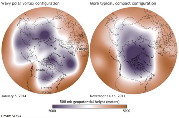
Wavier jet stream
One thing we do know is that the polar jet stream—a fast river of wind up where jets fly that circumnavigates the northern hemisphere—has been doing some odd things in recent years.
Rather than circling in a relatively straight path, the jet stream has meandered more in north-south waves. In the west, it’s been bulging northward, arguably since December 2013—a pattern dubbed the “Ridiculously Resilient Ridge” by meteorologists. In the east, we’ve seen its southern-dipping counterpart, which I call the “Terribly Tenacious Trough.”
These long-lived shifts from the polar jet stream’s typical pattern have been responsible for some wicked weather this winter, with cold Arctic winds blasting everywhere from the Windy City to the Big Apple for weeks at a time.
We know that climate change is increasing the odds of extreme weather such as heatwaves, droughts and unusually heavy precipitation events, but is it making these sticky jet-stream patterns more likely, too? Maybe.
Slowing, drunken path
The jet stream is a dastardly complex creature, and figuring out what makes it tick has challenged atmospheric scientists since it was discovered about 75 years ago. Even more elusive is figuring out how climate change will affect it.
Jet streams exist because of differences in air temperature. In the case of the polar jet stream, which is responsible for most of the weather we experience around the middle-latitudes of the northern hemisphere, it’s the cold Arctic butting against warmer areas to the south that drives it. (A more in-depth explanation can be found here.) Anything that affects that temperature difference will affect the jet stream.
This is where climate change comes in: the Arctic is warming much faster than elsewhere. That Arctic/mid-latitude temperature difference, consequently, is getting smaller. And the smaller differential in temperatures is causing the west-to-east winds in the jet to weaken.
Strong jets tend to blow straight west to east; weaker jets tend to wander more in a drunken north/south path, increasing the likelihood of wavy patterns like the one we’ve seen almost non-stop since last winter.
When the jet stream’s waves grow larger, they tend to move eastward more slowly, which means the weather they generate also moves more slowly, creating more persistent weather patterns.
I find it fascinating to try to pick out landmarks that I’ve seen from the ground in the photos.
Here’s a review from Tom Ross writing for Steamboat Today. Click through and read the whole article. Here’s an excerpt:
With his left hand firmly on the control stick of his vintage Piper PA-11 Cub Special aircraft, and a camera in his right hand, Fisher compiled an impressive portfolio of photographs of the Colorado River Basin from on high and bound them up into a new book, “Where the Colorado River is Born.”
“I either shoot out the left window or the right door,” Fisher said Wednesday from his current home on the Outer Banks of North Carolina. “I steer with my left hand and shoot with my right hand.”
Improbably, he uses the stick and rudder to manipulate the aircraft to frame his shot while he’s looking through the viewfinder of the camera.
Fisher picked an opportune time to self-publish a book of aerial photos of the Colorado River and its tributaries. Its release comes as even the average water user on Colorado’s Western Slope is fretting over the implications of a draft of the state’s new water plan due to be finalized in December. The plan is intended to answer the question, “Where will Colorado get the water it needs to support its cities and towns, industry and agriculture in 2050 while conserving the natural environment?”
As Fisher wrote in the foreword, he does not bring a particular environmental or political stance to the book. Rather, he wants people to be able to see the scale of the mountainous landscape that gives rise to the waters that sustain millions of people in seven states.
“My purpose is to educate those who cannot see these places directly so that they may determine for themselves the condition of their water supply and what is to be done about it,” he wrote.
Here’s another review from Jessica Cabe writing for the Glenwood Springs Post Independent. Here’s an excerpt:
Garrett Fisher can remember one defining moment in January 2014 when the idea came for his latest photo book, “Where the Colorado River is Born.”
“We got 28 inches of snow in Breckenridge,” Fisher said. “I had become aware of the water rights, and that particular property I was renting did not have the water rights.”
A Great Lakes native from Buffalo, New York, the concept of water scarcity did not cross Fisher’s mind until moving to Colorado, where until 2009 it was illegal for almost anyone to collect rain water or snow for personal recycling purposes. Two bills were introduced in 2009 that allow for some exceptions, but to this day many Colorado residents would be breaking the law to catch rain water or keep the snow they shovel from their driveways…
“I try to avoid telling people what to do because I think that doesn’t work,” he said. “My goal was to show people exactly where the water came from. I want to show people where the snow falls and where it goes.”
He said once people see something like that, it becomes real and relatable.
Fisher’s book contains 95 photos of the Upper Colorado, Roaring Fork, Blue, Gunnison, Eagle, Yampa and Uncompaghre river basins as well as the mountain ranges that feed them. He took these photos from his Piper PA-11 Cup Special, what he describes as the Model T of airplanes for their nostalgia factor.
“They were the first personal airplanes, or the first planes someone would buy to fly around and have fun,” he said. “It’s good for what I do. It flies slow, and it climbs aggressively. Also, the visibility is good as far as the plane parts being out of the way.”
For all these advantages, he trades comfort. Fisher took the photos that appear in “Where the Colorado River is Born” from March to June of 2014. Flying above mountains, hanging out the door of the plane with his camera, he wouldn’t have minded a heater.
Fisher said his favorite memory of photographing the river was his time flying above the Roaring Fork Valley.
“All of a sudden I got to 8,500 feet over Basalt,” he said. “I had the door open, and I was like, ‘It’s like summertime. I’m not freezing.’ And I didn’t have to worry about crashing into anything. I had forgotten how intense the flying was that I had gotten myself into. It required constant mental agility. But I cruised all over the valley, back and forth a few times, and then landed in Glenwood.”
Fisher said his book has a message, but he also wanted it to simply have aesthetic value as a coffee table book.
“If the photo’s not pretty, it doesn’t make it in,” he said.
But he hopes seeing this whole fascinating process — from snow falling on a mountain to the spring melt that takes the snow to the river — will open eyes about water in the West.
What is the difference between weather and climate change?
Weather refers to short term atmospheric conditions while climate is the weather of a specific region averaged over a long period of time. Climate change refers to long-term changes.
Perched at the podium during a Colorado Coalition of Land Trusts gathering, Erin Toll wears a poker face, a smart black pencil skirt and sassy Jimmy Choos. Among the jeans-and-hiking-boot-clad crowd attending, this wry New York transplant seems an unlikely hero. As recently as last fall, Toll, director of the Colorado Division of Real Estate, had no idea what a conservation easement was. But now, she says, protecting the integrity of land conservation is her number-one priority – and she’s cracking down on crooked deals with a vengeance.
Toll’s new enthusiasm for conservation easements, which offer landowners tax breaks in exchange for accepting limits on their right to develop, couldn’t come at a better time for Colorado’s land trusts. The state has seen some of the fastest-paced land conservation in the country, driven by a boom in both land trusts – the nonprofit organizations that hold easements – and in government open-space programs. Coloradans have protected nearly 1.8 million acres with conservation easements, much of it fueled by innovative tools, including a lottery-funded land protection program and a transferable state income tax credit.
Unfortunately, though, tax benefits sometimes breed abuses. And questionable conservation deals are drawing intense scrutiny – including Toll’s investigation into inflated real estate appraisals in Colorado and an ongoing Internal Revenue Service audit of hundreds of tax returns nationwide claiming federal tax breaks for donated easements. While state investigation and reform is moving swiftly, the federal audits have dragged on, frustrating landowners and creating confusion about easement appraisals.
The legal and financial complexities of conservation easements have reached a crossroads in Colorado. “What happens in Colorado could bleed out to the rest of the country,” says Lynne Sherrod, Western policy manager for the national Land Trust Alliance.
To help ferret out abusers, Toll has issued 30 subpoenas since November. So far, she’s suspended two appraisers who inflated appraisal values on more than 35 conservation easements. (She’s still wading through 44 boxes of evidence and says, “Every day we find more.”) The jacked-up appraisal values exploit a state program that offers landowners up to $375,000 in transferable tax credits for conservation easement donations. Land-conservation professionals say the program has been critical in protecting more than a million acres (at a cost of about $274 million) across the state since it took effect in 2000.
Although the majority of the state’s conservation easements are rock-solid, Toll rolls her eyes as she reveals some of the more outrageous exceptions. In a sampling of conservation easements from one group, Noah Land Conservation (also known as Colorado Natural Land Conservation), Toll found gross overvaluations of 111 easements on the eastern plains. The scheme involved 6,100 acres valued at $76.5 million (hence eligible for $37 million in state tax credits) by a mere three appraisers, on parcels that were meticulously subdivided so they could slip past county and state laws regarding acreage or subdivision development. In one particularly egregious example, the appraised value of a single 640-acre ranch leaped more than $14 million in a matter of days. Toll’s investigation is ongoing, but she’s narrowed the state’s spoilers down to about eight appraisers (including the two she’s already sanctioned), a couple of attorneys and a promoter or two – and their offenses, including possible securities fraud, could spread into the realm of other government agencies.
More conservation easement coverage here and here.
On Thursday’s warm, dry winter day, Rick Bly watched the sky as Colorado’s next big snow storm to roll in.
“Kind of hopeful it will bring the big snow that’s predicted,” said Bly.
He records moisture near Breckenridge. He says there was an above average snow in November, which was more than two times the normal amount, followed by a good December snowpack. But January and February saw a big drop.
“January was down substantially about 40 percent below average,” said Bly.
It’s still about 20 percent above average in the central parts of Colorado but that snow has been melting fast. It’s something he can see on his nearly snow-free Breckenridge driveway.
“Normally it’s completely covered [with snow], typically you don’t see our driveway till March,”‘ said Bly.
He hopes the wind blowing in will bring big snow to Colorado reservoirs.
“‘The spring will be here soon and there will be concerns about water,” said Bly.
From the Associated Press (Dan Elliott) via The Durango Herald:
The snowpack at the summit of Wolf Creek Pass was at only 46 percent of the median figure for the date. Cascade was the worst off at 23 percent of the median. El Diente Peak was at 40 percent, and the Upper San Juan was at 45 percent.
Even the healthiest snowpacks in the region are well below average. Lizard Head pass was at 85 percent Wednesday, Red Mountain Pass was at 78 percent and Mineral Creek was at 75 percent.
Plume of subtropical moisture streaming into Colorado September 2013 via Weather5280
From the Loveland Reporter-Herald (Pamela Johnson):
Millions of dollars have been spent and thousands of hours donated to help residents throughout Larimer County affected by the 2013 floods.
But there is still a large pot of money, volunteers and a collaborative team available to help those who lost their homes to the raging waters.
“We’re still here, and there are still ways of getting help,” said Laura Levy with the Long Term Recovery Team, a collaborative of nonprofits that came together to assist residents in obtaining help and funding after the floods. She was part of a Larimer County commissioners work session Thursday about community flood recovery.
“We want to make sure the word gets out to as many people as possible that money is still available.”
The Long Term Recovery Group has distributed just over $1 million with the help of its partners and still has $1 million left to help other residents.
And through that same group, 3,100 volunteers from across the country have spent 84,000 hours cleaning up debris and helping residents rebuild. These include faith-based organizations, service groups, college students and scores of local residents…
Amy Irwin of the Loveland Housing Authority is managing Community Development Block Grand Disaster Funds to help residents with housing costs. This could be moving and storage expenses, rental assistance, repair of homes or finding new homes.
“We have $1 million in that pot, and we have not been able to assist as many families as we would like because the vacancy rates in Larimer County are less than 2 percent,” said Irwin.
Because of the tight market, residents cannot find rentals that are within their price range as well as the range allowed under the parameters of the grant money.
Money that has been committed to her office through that federal grant program totals $8.5 million. Of that, $1 million is to help families still recovering from the High Park Fire and the rest is split across home repairs and ownership, rental assistance and road and bridge repairs to allow access to homes.
Funding to keep the Long Term Recovery Group operating will be phasing out over the next year, but Levy said they are committed to finding other sources or grants so the nonprofit partners can continue helping at full steam through all of 2015.
Funding for the Arkansas Valley Conduit has flatlined in the federal budget. Striking a somber tone, Executive Director Jim Broderick broke the news Thursday to the Southeastern Colorado Water Conservancy District. The district sought $5.5 million for the conduit in fiscal year 2016, but so far only $500,000 is included in a constricted federal budget.
“It’s hard to pinpoint the reason for flatlining,” Broderick said. “But I think this is a short-term problem. … The issue isn’t that we’re dead in the water, we’re just going slow.”
He speculated that the federal Office of Management and Budget frowned on the project because it has not yet begun moving dirt and a general policy that water-quality projects should involve the Environmental Protection Agency.
The conduit progress has been overseen by the Bureau of Reclamation, which shifted funds this year to boost conduit funding to about $3 million. However, there may not be much money available.
Reclamation had a $96 million budget for projects nationwide this year, but allocated $50 million to deal with California drought issues and $30 million to settle claims with American Indian tribes.
District officials are continuing with attempts to encourage reprogramming federal money for the project. In the interim, the district will work closely with state officials to find money and analyze the workflow toward building the conduit.
On a positive note, Broderick said the conduit could move up in the federal pipeline by 2019.
The $400 million conduit would reach 132 miles from Pueblo Dam to Lamar and Eads, and would serve 50,000 people in 40 communities. It was first authorized by Congress as part of the Fryingpan-Arkansas Project in 1962.
More Arkansas Valley Conduit coverage here and here.
The Pueblo Board of Water Works agreed to hire Black & Veatch Engineering for $130,000 to assess the risk of Clear Creek Dam, located in northern Chaffee County. The earthen dam, built on a glacial moraine, has experienced seepage during the past 20 years, creating the occasional need to lower water levels temporarily to fix problems, Steve Anselmo, water resources engineer, told the board. Seepage monitoring has revealed 300-700 gallons per minute at varying exit points.
In 1997, when the downstream face became set, the water level in Clear Creek was lowered and a drain blanket installed and low spots filled in. Additional low spots were filled in 2007, when the water level was lowered to replace the outlet gates.
No unusual problems occurred until 2014, when one flow stopped and a new seepage path was detected.
“The new seepage path created in 2014 has raised the question of how to determine if this seepage event and others that might occur in the future pose a risk to the safety of the dam,” Anselmo said in a memo to the board.
“What actions should be taken to address that risk?”
The Black & Veatch study will look at the probability of a significant event and develop short-term and long-term solutions.
Pueblo Water bought Clear Creek from the Otero Canal Co. in 1954 and in 2004 filed an application in water court that would nearly triple its storage capacity. Clear Creek can now store 11,439 acre-feet of water. A native water right produces a small amount of water, but most of the water in the reservoir is imported from the Western Slope through tunnels and ditches and moved into the reservoir by exchange.
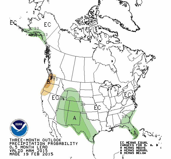
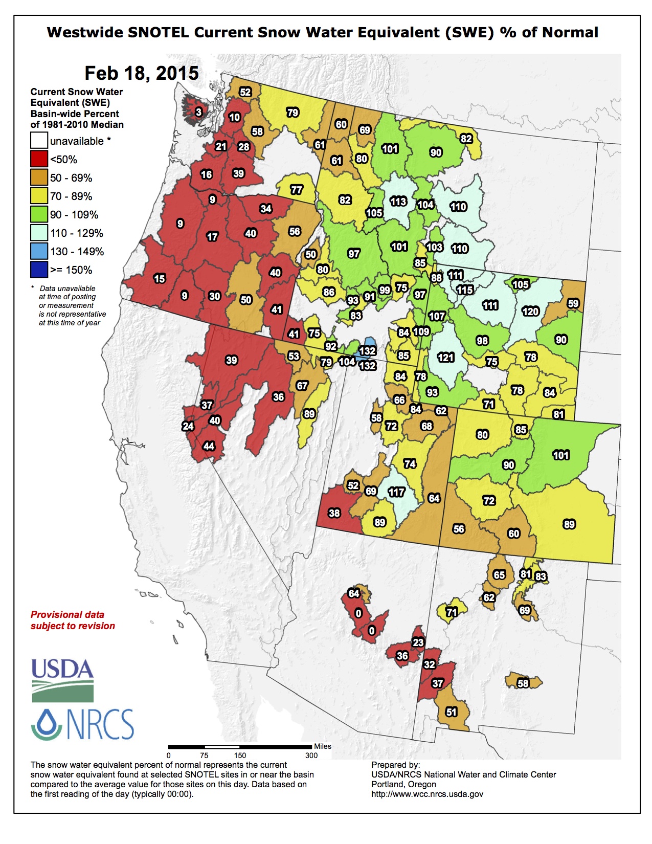
Seasonal Drought Outlook February 19 thru May 31, 2015 via the Climate Prediction CenterThree month precipitation outlook February 19 thru May 31, 2015 via the Climate Prediction CenterTemperature outlook February 19 thru May 31, 2015 via the Climate Prediction Center
Click on a thumbnail above to view a gallery of drought data from the US Drought Monitor. Click here to go to the US Drought Monitor website. Here’s an excerpt:
Summary
The upper-level circulation pattern during this U.S. Drought Monitor (USDM) week consisted of a persistent ridge over the western CONUS (contiguous United States) and trough in the east. The ridge kept temperatures warmer than normal and blocked significant precipitation, while the trough funneled cold and dry air masses across the CONUS east of the Rockies and well into the Caribbean. Weather systems moving in the upper-level flow brought above-normal precipitation to parts of the Rockies and adjacent High Plains and Upper Mississippi Valley. A large weather system at the end of the week brushed the Ohio Valley as it moved out of the Southern Plains and across the Southeast to Mid-Atlantic coast. It brought rain, snow, sleet, and freezing rain to these areas, but precipitation amounts were mostly below normal for the week…
The Plains and Midwest
Portions of the Northern Plains and Upper Midwest received half an inch or less of precipitation this week, but this registered as above-normal due to normal being low during the winter dry season. A handful of stations in Upper Michigan reported more than half an inch of precipitation. Much of the Central Plains to Lower Great Lakes reported little to no precipitation. Precipitation was below normal (half an inch or less) across most of the Great Plains, except portions of Texas and southeast Oklahoma which received an inch or more of precipitation. Although streamflow levels were significantly low, much of Kentucky was buried in 8 to 16 inches of snow this week, with liquid equivalents of an inch or more of precipitation, so no change was made to the depiction over the Bluegrass State. D0-D3 expanded in southwest Texas to the Texas panhandle due to re-evaluation of data…
The West
Half an inch to an inch of precipitation was reported in a few parts of the West, mainly northwest Washington and portions of the Rockies. Half an inch or less was received in other parts of the Pacific Northwest and Rockies and southeast Arizona, but most of the West received little to no precipitation this week. While storm systems during December and early February helped replenish some reservoirs, the precipitation fell mostly as rain instead of snow, so the mountain snowpack in the coastal ranges remained dismally below normal, severely impacting the ski industry. According to the National Resource Conservation Service (NRCS) SNOTEL network, mid-February snowpack snow water content ranked in the lowest 5 percent of the historical record at many stations throughout Washington, Oregon, California, and Utah, and, in fact, in most western states. Persistent well-above-normal temperatures continued to melt the snowpack, with snow depth decreasing as much as 4 to 12 inches in the last 7 days at many SNOTEL stations in the Pacific Northwest and Rockies. The University of California estimated statewide forage production decreased during January due to the month’s very dry conditions, and the Almond Board of California reported a decrease in almond shipments of about 28 percent in January 2015 compared to January 2014.
D0 was pulled back in eastern Washington, and D1 pulled back in Washington’s Lower Columbia Basin, to better reflect water-year-to-date precipitation conditions and soil moisture combined with the low snowpack water equivalent. In Idaho, the south central D3 was eliminated, D0-D2 was pulled back in the southwest and southeast areas, and D3 was expanded in the southwest to better reflect impact conditions and a tighter moisture gradient. D1 expanded in western Colorado, northeast Utah, and southwest Wyoming to better reflect low mountain snow water content and above-normal evapotranspiration due to persistently above-normal temperatures. The impact boundary was adjusted in this area to reflect short-term impacts.
In the Southwest, an area of D3 was added to northwest Arizona to reflect long-term (24-36 month) dryness. The D0 donut holes along Arizona’s Mongollon Rim were reduced in size, and the D0 in north central towards central New Mexico was filled in with D1, to reflect the low SNOTEL snowpack and reservoir situation. D4 was expanded in Mono and Inyo Counties in California and Esmeralda County in Nevada to reflect dryness in the short term (last 7 days to 6 months) and long term (last 48-72 months)…
Looking Ahead
The upper-level circulation pattern (of ridge west/trough east) will continue. Above-normal temperatures are expected over the western CONUS and below-normal temperatures east of the Rockies, with weekly temperature anomalies as much as 20 degrees below normal during the next 7 days. Another storm system will develop in the east, bringing an inch or more of precipitation to the Mid-Mississippi and Ohio Valleys and coastal Mid-Atlantic to Northeast. The NWS HPC 7-Day Quantitative Precipitation Forecast (QPF) also calls for half an inch or more of precipitation for February 19-25 across parts of the Rockies and central Plains, eastern portions of the Southern Plains, and most of the country east of the Mississippi River, while half an inch to no precipitation is forecast for the West.
The 6-10 day and 8-14 day outlooks expand the area of below-normal temperatures across the eastern CONUS to the Rockies, while above-normal temperatures should continue along the West Coast to Alaska. Drier-than-normal weather is expected for February 24-March 4 from the northern Plains to western Great Lakes and southwest Alaska, while precipitation should be above normal from parts of the southern Plains, across the Southeast, to the coastal Northeast. Pacific weather systems undercutting the ridge should bring above-normal precipitation to the West late in the period.
Clouds begin to increase [today] in advance of a major weather change on Friday with rain developing by late evening, then quickly changing over to snow. Snow will be heavy early Saturday, decreasing in intensity Saturday afternoon but continuing into Sunday with much colder highs: upper 20s Saturday, low 20s Sunday. By Monday morning there could be up to a foot of snow on the ground in parts of the greater metro area with the temperatures only in the single digits making for a very difficult Monday morning rush hour.
From the Associated Press (Dan Elliott) via The Albuequerque Journal:
Snowpack in the mountain valleys where the Colorado River originates was only a little below normal on Wednesday, marking one of the few bright spots in an increasingly grim drought gripping much of the West.
Measurement stations in western Colorado showed the snowpack at 90 percent of the long-term average.
By contrast, reporting stations in the Sierra Nevada range in drought-stricken California showed snowpack at 50 percent or less in early February, the most recent figures available. Some detected no snow at all.
Mountain snow in Colorado is closely monitored because a half-dozen Western waterways, including the 1,400-mile Colorado River, start in the area. The river and its tributaries supply water to millions of people in seven states and Mexico.
Much of the river comes from mountain snow that accumulates during winter and melts in the spring…
In the Pacific Northwest, warm temperatures have brought rain instead of snow, so the mountains aren’t accumulating snowpack for the spring runoff, when farmers and water managers need water to irrigate crops and refill reservoirs.
Snow accumulation in the Rocky Mountains in Colorado, Wyoming and Montana has been relatively good. Snowpack in the Colorado valleys that feed the east-flowing South Platte River were at 102 percent of average.
“Not spectacular, but not miserable, either,” Strobel said.
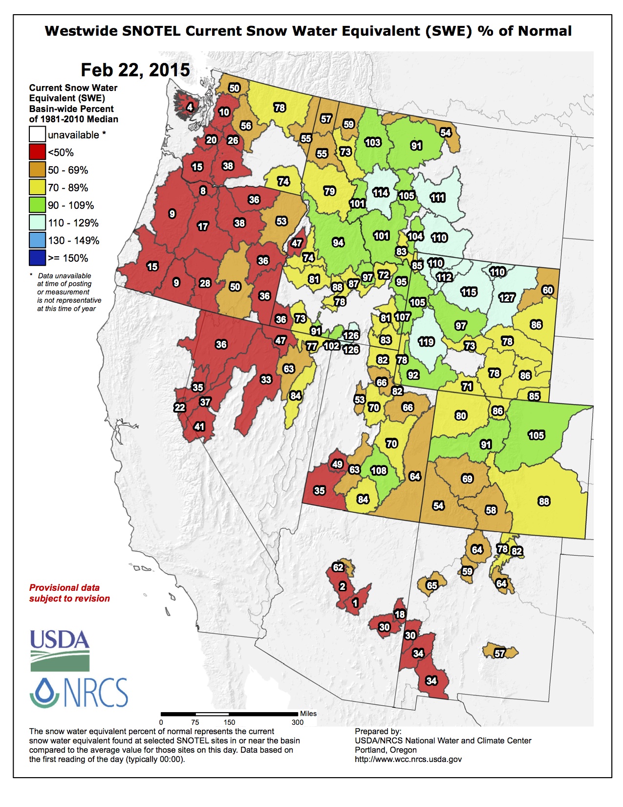
Even in Colorado, the picture is mixed. Statewide, including the Colorado River, the South Platte and six other basins, the snowpack stands at 78 percent of normal, with the parched southwest corner at 56 percent.
It would take half again the normal amount of snowfall between now and April to bring the statewide snowpack up to average, said Brian Domonkos, who supervises the snow survey in Colorado.
The Colorado River Basin isn’t accumulating snow as quickly as it was earlier in the season, Domonkos said Wednesday at a meeting of the state Water Availability Task Force, which monitors drought conditions.
“It’s been pretty dry since about the beginning of February,” he said.
The Colorado update came after calls for increased multi-state cooperation in the Colorado River basin due to the prolonged drought. The basin is home to 40 million people and 4 million acres of farmland.
Lake Mead in Nevada is the key measuring point of water in the Colorado River system, which also includes the Green, San Juan and Gila rivers and some 55 dams and diversions. The lake dropped to historic levels last year after almost 15 years of regional drought.
Las Vegas, with 2 million residents and 40 million visitors a year, gets 90 percent of its drinking water from Lake Mead. The U.S. Agriculture Department has declared most of Nevada a natural disaster area due to the drought.
A dry spell starting in late December and carrying through January has compromised Colorado’s snowpack and diminished a once promising water supply outlook, according to the Natural Resources Conservation Service.
SNOTEL data indicates this past January was the driest on record in 28 years in the Colorado mountains.
Overall, January brought just 1.4 inches of mountain precipitation, 45 percent of the average. January typically brings an average of 3.1 inches of mountain precipitation, ranking the month as the fourth most important for precipitation in the year.
The South Platte had the greatest precipitation totals statewide, reaching 62 percent of average.
“With nearly one third of the winter gone, Colorado is running short of time to catch up,” said Brian Domonkos, Colorado Snow Survey supervisor, in a press release. “Statewide, snowfall would need to amount to 124 percent of normal snowfall from now ‘til mid-April to achieve normal snowpack peak levels.”
There are few silver linings with a snowpack as poor as the one now sitting at the headwaters of the Rio Grande River.
But Division Engineer Craig Cotten said recent warm temperatures in the San Luis Valley have not prompted much runoff from the basin’s high country, where snowpack was at 65 percent of average at the beginning of the month.
“We’re still pretty steady, about where we usually are,” he said.
Still, the existing snowpack does not bode well for irrigators come springtime.
The Natural Resources Conservation Service has forecast a flow of 457,000 acre-feet on the Rio Grande, which is 70 percent of average.
The forecast for the Conejos River is about 210,000 acre-feet, which would be about 60 percent of average.
“So, not great at this point,” Cotten said.
The Conejos and the Rio Grande are the two rivers in the valley with obligations to send water downstream to satisfy an interstate compact with New Mexico and Texas.
If the projections hold, the Rio Grande would be required to send 110,000 acre-feet downstream, while the Conejos would be obligated to send 51,000 acre-feet.
But the warm weather has prompted several requests to move up the irrigation season from its typical beginning in April.
Cotten said February is too early to consider such requests but they’ll get a closer look in March.
As the water year progresses, Cotten’s office also will begin using a new stream forecasting service from the National Weather Service.
The information from the weather service would predict flows on the Rio Grande, Conejos, San Antonio and Los Pinos rivers, the latter two of which are tributaries of the Conejos.
Last year, water officials from around the valley said inaccuracies with the NRCS’ snowpack measurement and forecasting services made it difficult to meet the requirements of irrigators while also sending the required amount of water downstream to satisfy the compact.
The weather service’s forecast will provide multiple scenarios and be used in conjunction with the one normally issued by the NRCS.
“Hopefully, they’ll be very close and fairly similar,” he said. “If not we’ll have to have some discussion and see what’s going on.”
This winter’s snow pack in the Colorado Rockies is slightly below average, a relatively good sign for states, including Arizona, that use Colorado River Water.
Measurements taken in the mountain valleys of western Colorado, where the Colorado River originates, put snow pack at 90 percent of the long-term average. Officials from the U.S. Department of Agriculture, which runs the snow survey, said that’s not spectacular – but not miserable either.
Mountain snow in Colorado is closely tracked because when it melts it feeds the Colorado River, which provides water to seven states, including Arizona.
Snow pack in other parts of the West is not looking as good as in Colorado.
The last measurement taken in the Sierra Nevada range put snow pack at 50 percent or less. There was no snow at all at several measurement stations.
And in the Pacific Northwest, warm temperatures have brought rain instead of snow, which means there won’t be much water to refill reservoirs with come spring.
Other than Colorado, not spectacular but not miserable levels of snow pack have been measured in Montana and Wyoming as well.
Don Brown of Yuma is just one vote away from becoming Colorado’s newest Commissioner of Agriculture.
Brown won unanimous confirmation from the Senate Agriculture, Natural Resource and Energy Committee on February 12. He was joined by his mother, wife, three children and two grandchildren.
Former Commissioner Don Ament of Iliff also stood with Brown during the hearing, as did outgoing Commissioner John Salazar.
With Sonnenberg as its chair, shenanigans in the ag committee were to be expected, and the committee did not disappoint. They played a practical joke on Brown and the governor’s staff by voting 5-4 to turn down the nomination. Sen. Lucia Guzman, D-Denver, said she couldn’t vote for a member of the United Methodist Church (Guzman is a United Methodist minister), and other committee members came up silly reasons to reject the nomination. Said Sen. Mary Hodge, D-Brighton, “I grew up in Yuma. I’m sorry, no.” And Sonnenberg wrapped it up. “I guess I don’t have the control and power I thought I had,” which led the committee to then solicit nominations for ag commissioner from the audience.
After a good laugh by all, the committee voted unanimously to send Brown’s nomination to the full Senate for confirmation, with hearty congratulations and warm welcomes to Brown and his family…
Sonnenberg had a pretty good day on February 12 with his committee. In addition to marshaling Brown’s nomination, he got approval for two bills that have been on his radar for several years.
Senate Bill 15-064 would prohibit the US Forest Service and federal Bureau of Land Management from attempting to supersede Colorado water law by putting conditions on special permits that include water rights.
The issue dates back to late 2011, when the US Forest Service issued a directive to require water rights from those who lease federal lands for ski operations or grazing. The Forest Service claimed they wanted the rights to protect them should a ski area decide to sell them, although that has never happened in Colorado. In 2012, a federal judge ruled against the Forest Service, not on the merits of the case, but because the agency failed to follow its own rules. The Forest Service withdrew the directive.
Last year, the Forest Service issued three directives on water rights, including a new one on the ski area water rights that bears little difference from the 2011 directive. Kristen Moseley, a water rights attorney representing the Colorado Water Congress and several Colorado water authorities, told the ag committee Thursday that the Forest Service directives imply that the Forest Service owns water rights by virtue of owning the land. These water rights have already been adjudicated, Moseley said. SB 64 will protect Colorado water rights, she said.
James Eklund, director of the Colorado Water Conservation Board (CWCB), also testified in support of SB 64. The CWCB is an agency of the Colorado Department of Natural Resources.
Several environmental groups testified in opposition to SB 64, including the Audubon Society and Western Resource Advocates (WRA). Jen Bolton of the Audubon Society said the bill conflicts with federal law, and attorney Rob Harris of WRA testified that the bill was overly broad and that the proper place for resolving the issue is through a negotiated settlement rather than state law.
The bill passed on an 8-1 vote and goes to the full Senate for further consideration.
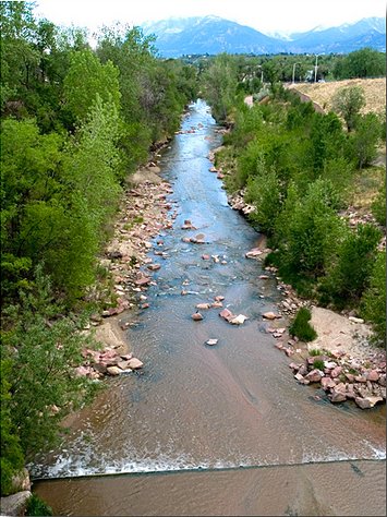
Fountain Creek through Colorado Springs. FromThe Pueblo Chieftain (Chris Woodka):
Pleas to reconsider a federal lawsuit over water quality fell on skeptical ears Wednesday.
The Lower Arkansas Valley Water Conservancy District board listened patiently to Colorado Springs Councilman Merv Bennett’s assessment of stormwater protection progress, but in the end voted to continue to pursue a federal court filing charging that Colorado Springs is violating the Clean Water Act.
The board instructed attorney Peter Nichols to continue building a case.
Bennett urged the Lower Ark board to stay out of court, saying money would be better spent elsewhere. Still the board voted 7-0 to continue the lawsuit.
“Nothing’s binding on this council, the next council or the next mayor,” board member Melissa Esquibel said, clearly frustrated by Bennett’s promises. “It’s the same conversation, the same lack of movement that we’ve had. What’s going to happen?”
Colorado Springs City Council last month commit ted $19 million annually to stormwater projects, shuffling existing funds in the city’s general fund and adding $3 million from Colorado Springs Utilities beginning in 2016.
But Jay Winner, general manager of the Lower Ark, asked Bennett if other funds in the city would be shorted in the process and political pressure would again lower stormwater as a priority.
Bennett countered that the current council is committed to funding stormwater control, as well as the candidates for mayor in the April municipal election. He said the city’s other problems, such as potholes, would be settled in some other way not related to stormwater. He maintained the city currently is spending the required amount on stormwater and council’s action makes the funding permanent.
“I believe in the integrity of the people running,” Bennett said in response to Esquibel’s comments. “I feel we’ve made progress and we’ll continue to make progress.”
But he acknowledged that three to five new members may be elected to the nine-member council, and he could not personally guarantee that the stormwater money would remain in place.
“I can’t solve it by myself and we can’t solve it overnight,” Bennett said.
Winner pressed Bennett on several issues, including the council’s 2009 decision to dissolve its stormwater enterprise, stormwater funding that has been missing in the intervening years and whether the money would go toward projects identified when the enterprise was formed in 2005.
Bennett agreed that council made the wrong decision in response to Doug Bruce’s Issue 300 in 2009. He said Colorado Springs is working on a report that would show its funding level for stormwater projects has been higher than the $17 million the stormwater enterprise would have generated each year.
He pledged to have city staff develop a side-by-side comparison of projects.
The stormwater issue is tied to Pueblo County’s 1041 permit for Southern Delivery System, which was negotiated earlier in 2009, before the stormwater enterprise was abolished. Flood control is needed because growth in Colorado Springs has elevated flows on Fountain Creek, increasing the danger of flooding in Pueblo.
Arkansas River Basin High/Low graph February 17, 2015 via the NRCS
Upper Colorado River Basin High/Low graph February 17, 2015 via the NRCS
Gunnison River Basin High/Low graph February 17, 2015 via the NRCS
Laramie and North Platte Basin High/Low graph February 17, 2015 via the NRCS
Upper Rio Grande River Basin High/Low graph February 17, 2015 via the NRCS
San Miguel, Dolores, Animas, and San Juan Basin High/Low graph February 17, 2015 via the NRCS
South Platte River Basin High/Low graph February 17, 2015 via the NRCS
Yampa and White Basin High/Low graph February 17, 2015 via the NRCS
Click on a thumbnail graphic for a gallery of snowpack data from the Natural Resources Conservation Service.
From the Associated Press via The Columbus Republic:
The Colorado Water Availability Task Force will meet Wednesday in Denver.
Colorado’s statewide snowpack stands at about 79 percent of the long-term average. The snow depth was 92 percent of average in the basin that gives rise to the Colorado River, which supplies water to seven states including California.
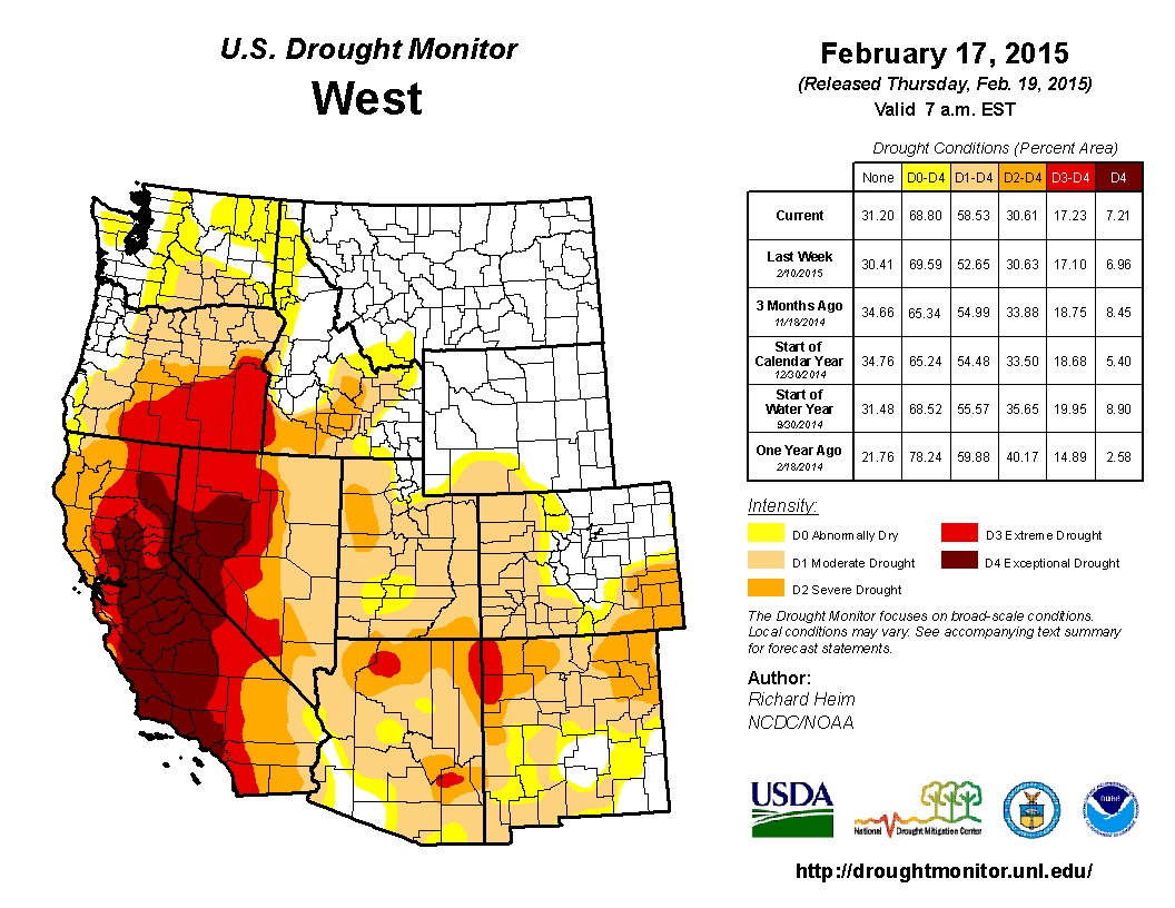
Much of the West is in a drought. The U.S. Drought Monitor lists parts of California and Nevada as under extreme or exceptional drought, the driest of five categories.
The U.S. Agriculture Department’s National Water and Climate Center says January was unusually warm and dry across the West.
Groundwater movement via the USGS FromThe Mountain Town News (Allen Best):
To grasp the immensity of the groundwater pumping in California during the last century, think back to the last time you flew into Las Vegas. Before descending into McCarran International Airport, you may have swept across Lake Mead. When full, the reservoir is 112 miles long and up to 532 feet deep. It can hold up 28 million acre-feet of water, or about two average-year flows of the Colorado River before diversions.
That, according to the Los Angeles Times, is how much water has been removed from California’s Central Valley since the advent of groundwater pumping. It’s staggering, the very definition of unsustainable.
Groundwater depletion is a problem not just in California, but across the country. Resources created during geologic timescales are being depleted in human lifetimes for cities and farms. In the United States, 14 percent of all water used to irrigate crops comes from mining groundwater aquifers.
Cheap energy and advances in pumping technology around the end of World War II accelerated this depletion. We have gained the artifice of cheap food and irrigated luxuriance in arid environments. The extraction of water above the rate of recharge is now close to 400 cubic kilometers.
“We are robbing our savings account,” says Andrew Stone, executive director of the American Ground Water Trust. Stone points out that population growth and the uncertain effects of climate change will apply more pressure to these subterranean savings accounts.
It’s not inevitable that we pinch these piggy banks until they’re empty. Los Angeles after World War II turned to groundwater exploitation to satisfy growth. But over time it was able to shift to other mechanisms, including recycling, to meet population needs.
Agriculture regions have been slower to adapt. The Central Valley has been Exhibit A in groundwater mining for many decades. It’s 450 miles up and down and, at a maximum, 60 miles wide and wonderfully productive. One-eighth of total agriculture production in the United States occurs here on 1 percent of the land. From avocados to artichokes, potatoes to peppers, much of your grocery store’s produce likely comes from the Central Valley. “Everyone eats there,” as a headline in the New York Times Magazine noted several years ago.
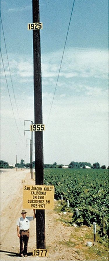
Snowmelt from the Sierra Nevada provides some of the water for the crops, but aquifers have allowed the great expansion of farming. This is mining, and similar to mining for ores, aquifer pumping can cause the earth itself to subside. One famous photograph taken in California’s Central Valley in the 1970s of a tall telephone pole showed the extent of subsidence, nearly 30 feet at that point.
Soon after that photograph was taken, proposals to methodically address groundwater depletion were laid on the desk of California’s handsome young governor, Jerry Brown. It went nowhere. The issue was too fractious in California then. Only baby steps were taken over the next several decades.
Other states in the West have been more aggressive in adopting state-wide regulation. Colorado’s regulations, for example, were adopted in the late 1960s. They haven’t been a cure-all. Unsustainable extraction of the Ogallala aquifer continues. Denver’s fast-growing southern suburbs, with some of the wealthiest and best-education demographics in the country, depend almost 100 percent on rapidly declining aquifers.
There is no one answer to this unsustainable aquifer mining. Certainly, increased recycling will be one response, as it has been in Los Angeles and soon will be in Denver’s south suburbs. We’ll have to revise our expectations of landscaping, and continue to tinker with how technology can make more efficient use of our supply.
In California, Gov. Brown, now bald and in his 70s, last September signed a trio of laws that together give local jurisdictions tools for planning how to achieve sustainability by 2040. Sustainability here is defined as aquifers recharging, through percolation or direct injection, as rapidly as they are withdrawn. But the laws also reserve a big stick. If local jurisdictions don’t, the state eventually will elbow into local affairs to get the planning done.
Recycling alone can’t alone be the answer for California’s Central Valley or other regions west of the 100th meridian so utterly dependent upon mining of aquifers. Fundamentally, our cheap food, like our cheap energy, is an illusion.
A century ago, hard-rock miners were still making a mess of the West, clawing out high-value minerals and creating the acid-mine drainage, now a significant problem and expense. Ignorance perhaps excuses their actions. With groundwater mining, we have no excuse. We already know we’re on unstable ground.
HB15-1167 is up for hearing tomorrow in the House Agriculture, Livestock, & Natural Resources committee. The bill is the brainchild of J. Paul Brown representing District 59 down in southwestern Colorado. It would direct the CWCB to study the feasibility of new mainstem storage on the South Platte River downstream from Greeley. It also directs the CWCB to utilize existing studies of the possibility of pumping water from the Missouri River Basin back to Colorado. I suppose he’s talking about the USACE’s alternative to Aaron Million’s pipeline from the Green River or the Kansas Aqueduct project.
The bill calls out the Narrows Dam Project (650,000 AF) that was authorized by the US Congress but never built for a number of reasons, most of which would be faced by any new mainstem project.
Senator Sonnenberg shows up as the Senate sponsor.
Here’s what Representative Brown had to say on the subject in the Pagosa Daily Post:
My time in the legislature is challenging and exciting. I am working hard on my bills as well as keeping up on my committee bills and the bills that come to the floor. I actually have a little advantage over other legislators in that my apartment is half a block from the Capitol, so all of my time, when I am not sleeping, showering, or attending receptions, is spent reading and preparing for action on bills.
My number one issue is water storage and primarily storage in the South Platte drainage in Colorado. Why on the South Platte? Because that is the one drainage on the eastern side of Colorado that regularly has water that leaves the state that can legally be stored and used in Colorado. When I was in the legislature in 2011 and 2012 I started paying attention to the water in the South Platte Basin that was leaving the state. There were two years in particular where over 1,000,000 acre feet per year were wasted, another where 600,000 acre feet left the state, and even today there is excess water running out of the state that could be used to augment other water needs in Colorado. If we could store that water, it would help to satisfy the demand on the Front Range and relieve the need to send water from the Western Slope to the more populated Eastern side of the Continental Divide.
For the past many years I have been learning all I can about water, water law, water compacts with other states, and everything else related to water that I could possibly learn. I started at a young age when my parents were paid to measure the water at the Colorado/New Mexico state line on the La Plata River South of Hesperus, Colorado. On most early mornings before I caught the bus for school I would measure the amount of water in the river. That information was then relayed to the water authorities in both states where ditches were closed or opened depending on their priority. I have monitored Governor Hickenlooper‚s „water plan‰ and have attended as many Water Roundtable meetings as I could possibly make. I have attended the Colorado Water Congress meetings amongst the most knowledgeable water lawyers and providers in Colorado.
I still have much to learn.
Everywhere I go I have asked folks about storage on the South Platte. The more I have learned, the more it became evident that all of the information needed to make good decisions on where and how to store water was scattered in many different places. I decided that it was necessary to pull all of that information together and that the easiest way to do so is to run a bill. That bill is HB15- 1167. It will be heard in the House Agriculture, Livestock, and Natural Resources Committee upon adjournment on the 18th of February.
Here’s the release from the United States Geological Survery:
The effects of dam removal are better known as a result of several new studies released this week by government, tribal and university researchers. The scientists worked together to characterize the effects of the largest dam removal project in U.S. history occurring on the Elwha River of Washington State. New findings suggest that dam removal can change landscape features of river and coasts, which have ecological implications downstream of former dam sites.
“These studies not only give us a better understanding of the effects of dam removal, but show the importance of collaborative science across disciplines and institutions,” said Suzette Kimball, acting director of the U.S. Geological Survey.
Five peer-reviewed papers, with authors from the U.S. Geological Survey, Reclamation, National Park Service, Washington Sea Grant, NOAA Fisheries, the Lower Elwha Klallam Tribe, and the University of Washington, provide detailed observations and insights about the changes in the river’s landforms, waters and coastal zone during the first two years of dam removal. During this time, massive amounts of sediment were eroded from the drained reservoirs and transported downstream through the river and to the coast.
One finding that intrigued scientists was how efficiently the river eroded and moved sediment from the former reservoirs; over a third of the 27 million cubic yards of reservoir sediment, equivalent to about 3000 Olympic swimming pools filled with sediment, was eroded into the river during the first two years even though the river’s water discharge and peak flows were moderate compared to historical gaging records.
This sediment release altered the river’s clarity and reshaped the river channel while adding new habitats in the river and at the coast. In fact, the vast majority of the new sediment was discharged into the coastal waters of the Strait of Juan de Fuca, where the river mouth delta expanded seaward by hundreds of feet.
“The expansion of the river mouth delta is very exciting, because we are seeing the rebuilding of an estuary and coast that were rapidly eroding prior to dam removal,” said USGS research scientist and lead author of the synthesis paper, Dr. Jonathan Warrick.
Although the primary goal of the dam removal project is to reintroduce spawning salmon runs to the pristine upper reaches of the Elwha River within Olympic National Park, the new studies suggest that dam removal can also have ecological implications downstream of the former dam sites. These implications include a renewal of the sand, gravel and wood supplies to the river and to the coast, restoring critical processes for maintaining salmon habitat to river, estuarine and coastal ecosystems.
“These changes to sediment and wood supplies are important to understand because they affect the river channel form, and the channel form provides important habitat to numerous species of the region,” stated USGS research scientist and river study lead author, Dr. Amy East.
The final stages of dam removal occurred during the summer of 2014. Some sediment erosion from the former reservoirs will likely continue. The Elwha Project and research teams are continuing to monitor how quickly the river returns to its long-term restored condition.
“We look forward to seeing when the sediment supplies approach background levels,” said Reclamation engineer and co-author, Jennifer Bountry, “because this will help us understand the length of time that dam removal effects will occur.”
The five new papers can be found in Elsevier’s peer-reviewed journal, Geomorphology, and they focus on the following topics of the large-scale dam removal on the Elwha River, Washington (web-based publication links using digital object identifiers, doi, are provided in parentheses):
Click here to go to the State of the Rockies Project website to read the report. Here’s an excerpt:
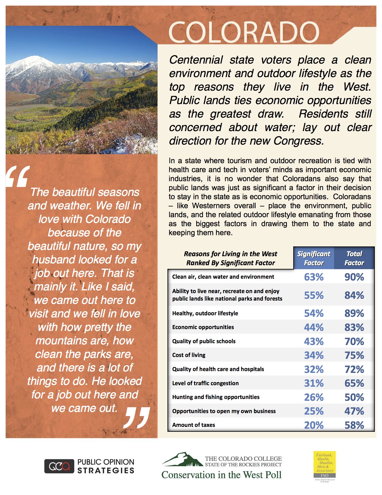
The 2015 Conservation in the West Poll, now in its fifth year, was recently released by Colorado College’s State of the Rockies Project. The survey of 2,400 registered voters in six western states provides an annual glimpse of voters’ leanings on land use, water supplies, the impact of public lands on the economy, and a variety of other related issues.
Designed by a bipartisan team of Republican and Democratic opinion researchers, the annual poll provides insight into Western attitudes. This year’s results are consistent with those of previous years, although a few new questions probed opinions of public-land management and the perceived relationship between environment and quality of life.
Four hundred residents in each state – Arizona, Colorado, Montana, New Mexico, Utah, and Wyoming – were asked about such issues as conservation, environment, energy, the role of government, trade-offs with economies, and citizen priorities.
The poll, conducted Dec. 29, 2014 and Jan. 3-11, 2015, has a margin of error of 4.9 percent.
From the Associated Press via the Glenwood Springs Post Independent:
A storm dropped more than a foot of snow on parts of the Colorado mountains Monday and left some roads in Denver and Colorado Springs glazed with ice for the morning commute.
The Western Slope, meanwhile, continued its dry stretch, with Aspen Mountain and Sunlight Mountain getting only an inch of new snow.
Eldora Mountain Resort near Boulder reported 15 inches of new snow. Breckenridge and Winter Park ski areas reported 7 inches.
The National Weather Service said 13 inches fell near St. Marys Glacier in Gilpin County in the mountains west of Denver…
The statewide snowpack, which accounts for much of Colorado’s water, stood at 81 percent of the 30-year average before the storm hit.
Snow depth in the South Platte, Arkansas and Colorado river basins ranged from 91 to 102 percent of average, while the southwest corner of the state remained locked in a drought, with snowpack at 60 percent to 75 percent of average.
The northwest corner of the state had about 85 percent of average snowpack.
From the USDA via the High Plains/Midwest Ag Journal:
An unusually warm, dry January slowed snowpack accumulation in much of the West, according to data from the second 2015 forecast by the United States Department of Agriculture’s National Water and Climate Center. California, Arizona and New Mexico, as well as parts of Colorado, Utah, Oregon and Nevada, remain in prolonged drought.
“January is usually a big month for snowpack accumulation,” NWCC hydrologist Cara McCarthy said. “But most of the West didn’t see significant gains this month. With isolated exceptions, only Arizona, New Mexico, Utah and Montana received near average precipitation last month.”
“This is as low a snowpack as I’ve seen across the Sierra Nevada and Cascades for many locations at this time of year,” said NWCC Director Mike Strobel. Several Snow Telemetry sites in those ranges are snowless, which is very unusual for this time of year.
Even the precipitation in the Southwest wasn’t enough to take these regions out of drought conditions. In Western states where snowmelt accounts for the majority of seasonal water supply, information about snowpack serves as an indicator of future water availability. Streamflow in the West consists largely of accumulated mountain snow that melts and flows into streams as temperatures warm in spring and summer. NWCC scientists analyze the snowpack, air temperature, soil moisture and other measurements taken from remote sites to develop the water supply forecasts.
The Cascades of Oregon and Washington have received normal levels of precipitation this water year, but it’s mostly fallen as rain instead of snow. California’s Sierra Nevada has seen little rain or snow. The extreme drought in California may be further aggravated by reduced streamflow in other parts of the West.
“This month the inflow forecast for Lake Powell fell from 90 to 70 percent of normal,” said McCarthy. “Because southern California draws water from the Colorado River, this may impact their water supply. This is only the second forecast of the season, and there’s still time for conditions to change. We’ll keep watching conditions and updating our forecasts as the year continues.”
The NWCC, part of USDA’s Natural Resources Conservation Service, monitors conditions year-round and will continue to issue monthly forecasts until June. The water supply forecast is part of several USDA efforts to improve public awareness and mitigate the impacts of climate change, including drought and other extreme weather events. Through the creation of the National Drought Resilience Partnership, launched as part of the president’s Climate Action Plan, federal agencies are working closely with states, tribes and local governments to develop a coordinated response to drought.
Since 1939, USDA has conducted snow surveys and issued regular water supply forecasts. Other resources on drought include the U.S. Drought Monitor. For information on USDA’s drought efforts, visit USDA Disaster and Drought Information. To learn more about how NRCS is helping private landowners deal with drought, visit the NRCS’ drought resources.
From Colorado Corn Growers via the High Plains/Midwest Ag Journal:
The Colorado Corn Growers Association’s Public Policy Committee voted recently to put its support behind three more bills during the 2015 Colorado Legislative Session, bringing the total number of bills the group is supporting to six.
These bills focus on a variety of issues, covering pesticide applicator rules, mineral rights, road regulations, water and renewable energy.
Meanwhile, the group is monitoring a number of other bills, and considering support or opposition for those as well, as the 2015 Colorado Legislative Session moves forward.
The three bills that CCGA’s Public Policy Committee most recently voted to support include:
• Senate Bill 15-119, “Sunset Pesticide Applicator”—The existing Colorado Pesticide Applicator Act expires in September of this year. This bill would renew the Pesticide Applicator Act, and also implement recommendations made by the Colorado Department of Agriculture.
• Senate Bill 15-093, “Compensate Owners Min Interests Extraction Regs”—Whenever a local government adopts or implements an ordinance, resolution, rule or regulation concerning mineral extraction that would reduce the fair market value of the owner’s mineral interest by at least 60 percent, this bill would specify that owner’s interest is deemed to have been taken for public use. This bill would then allow the impacted mineral owners to obtain compensation from the local government for the full diminution in the fair market value of the owner’s interest caused by the regulatory impairment.
• Senate Bill 15-023, “Off-highway Vehicle State Highway”—Currently, off-highway vehicles may cross streets, roads or highways if the driver complies with certain snowmobile statutory standards. This bill would import the snowmobile standards into the off-highway vehicle statutes. The bill also clarifies that a driver may cross a state highway if the driver complies with these standards.
The city of Steamboat Springs and the Yampa Valley Housing Authority are advertising for bidders on a water and sewer project in Fish Creek Mobile Home Park that would combine replacement of the city’s sanitary sewer interceptor that happens to run through the park, while accomplishing a much needed replacement of water and sewer lines to park’s 67 mobile homes.
“Talk about a partnership — the city has been terrific,” Housing Authority Board Chairwoman Kathi Meyer said Monday. “The city’s departments that do the bid work and public works have been very helpful in putting this together.”
Combining the city’s sewer interceptor project with water and sewer line replacement for the homes in the mobile home park, which is owned and managed by the Housing Authority, represents an economy of scale, Meyer said. It will allow the successful bidder to stage the job site once for both jobs and avoid incurring the extra expense of disrupting homeowners’ driveways and retaining walls twice.
Replacement of the city sewer interceptor already was on its list of prioritized capital projects. Merging the two projects required multiple departments having the will to “figure out how do we do it?” Meyer added.
The city loaned the Housing Authority $954,000 in 2007 to help with purchase of the mobile home park from Bob and Audrey Enever, who had owned it for 33 years. The Housing Authority took out an additional bank loan of $2.58 million, counting on lot rent to cover the debt.
Everyone involved understood that the park’s infrastructure was aging and required frequent repairs, but the Housing Authority’s cash flow was tied up with debt service.
Three years ago, the Authority’s consulting engineering firm, Drexel Barrell, informed the board that it needed to replace the water and sewer lines.
“We knew it was original infrastructure. Some of the sewer lines run underneath the homes,” Meyer said. “Over the last eight years, there have been ongoing maintenance issues. We’ve been lucky that although breaks over the last few years have caused inconvenience to tenants, there hasn’t been a significant incident.”
Fortunately, prevailing lending terms allowed the board to refinance the original bank loan, this time with Alpine Bank, at a lower interest rate. The freed-up revenue stream allowed the Housing Authority to leverage a loan through the Colorado Water Resources and Power Development Authority to fund the water and sewer work.
“The stars aligned,” Meyer said, securing an important source of workforce housing in the community for perhaps another 50 years or so.
At February’s Norwood town board meeting, trustees discussed the Colorado Water Conservation Board’s upcoming decision on a grant award that Norwood recently applied for. The funding would make possible a feasibility study that will determine whether or not Norwood should move forward with a lawn and garden raw water irrigation project, similar to that of Dove Creek.
Last month, town officials met with those of Dove Creek to learn the details of the project.
Town Administrator Patti Grafmyer said that receiving the grant would not mean that the irrigation project will automatically move forward.
“Norwood can evaluate the feasibility study,” she said. “We are just asking for the funding, but once that has happened, there will be a scope of work that will have to be signed with the town board.”
The Montezuma County commission and San Juan Basin Farm Bureau have publicly come out against a fledgling proposal to create a National Conservation Area on the Lower Dolores River.
Citing concerns that the designation could result in additional water being released downstream from McPhee Reservoir, the commissioners voted 3-0 to oppose any such plan…
But others involved said it is too early to take sides because the bill is still in a draft form and has not been released to the public yet.
“I think there is some misunderstanding of the intent of the NCA,” said Al Heaton, also a member of a legislative committee. “Once it’s out, there will be significant time for the public to read the draft and weigh in on it. It’s good to air it out, because there’s room for discussion, clarification and negotiation.”
The Lower Dolores Plan Working Group has been researching legislation for an NCA on the Lower Dolores River below McPhee dam since 2010. A draft is near completion and is expected to be available for review in the coming weeks.
At Monday’s commissioner meeting, Suckla said a draft he saw was “disturbing.” He was critical of the balance of 15 organizations listed in a memorandum of agreement directing the NCA proposal.
“This list is so unfair as far as equal representation for citizens of the county,” he said. “As a commission, our job is to protect property and water rights in Montezuma County, and I only see five entities here that side with that. Where’s the mining interests, the farm bureau, the private landowner interests?”
A compromise
The Lower Dolores Working group, representing various stakeholders, has been studying the environmental and commercial needs of the river below the dam for over a decade.
One conclusion reached was that improving habitat for the native roundtail chub, bluehead sucker, and flannelmouth sucker on the Lower Dolores will help prevent them from being listed by the Endangered Species Act, federal intervention local officials want to avoid.
An NCA in the valley from below McPhee dam to the confluence with the San Miguel River was proposed because the designation is seen as a flexible management tool with more local control in finding negotiated solutions to problems.
As part of the deal, the section of Dolores River that runs through the proposed NCA would be stripped of its “suitability” status for a Wild and Scenic River, a highly protectionist federal designation. If Congress ever approved Wild and Scenic for the Dolores, it would likely come with a federally reserved water right, a situation opposed by local officials.
Proponents say an NCA is a good fit because it balances conservation with commercial uses, eliminates Wild and Scenic potential for that section of river, and offers more local control than, say, a national monument.
“The group reached consensus to pursue an NCA as a way to protect values in a way that doesn’t feel threatening to some stakeholders,” Amber Kelley, Dolores River coordinator for the San Juan Citizens Alliance, said in an earlier interview. “The decision to develop an NCA as an alternative to Wild and Scenic suitability entails a compromise for everyone involved. A grass roots proposal is a far better option than having something imposed from the outside.”
But at the commission meeting some were skeptical of the NCA plan, and urged that the area continue under BLM management.
“I believe there is another way to protect fish without an NCA,” Suckla said.
‘Unintended consequences’
In a letter, the local Farm Bureau outlined its opposition, saying an NCA threatened the region’s water resources managed by the Montezuma Valley Irrigation Company and the Dolores Water Conservancy District, which operates McPhee Reservoir.
“The proposal has conflicting requirements with respect to its description of water rights and could set the stage for serious litigation,” according to the letter. “Except for new storage, the only . . . water supply . . . is from either MVIC or DWCD. This legislative path would set up a community fight between MVIC shareholders and DWCD full-service farmers.”
The letter goes on to say that the NCA proposal “does not include a water right” but because of uncertainties in federal and state water law, an NCA may have “unintended consequences driven by political or judicial actions initiated by folks with interests different than our interests.”
“We must ask ourselves, ‘are we supporting actions that may expand the ability of those interests to use the legal process to acquire water we did not intend to be available for acquisition?’”
A crux of the issue is how to improve downstream flows to benefit native fish. State and federal fish biologists have long recommended increasing McPhee’s designated fish pool for release to the Lower Dolores to 36,500 acre-feet from it’s current allocation of 31,800 acre-feet. But where the additional 4,701 acre-feet will come from has been a long-running debate.
Farm Bureau spokesperson Linda Odell said the fear is that an NCA could force the Bureau of Reclamation to acquire the additional 4,701 acre-feet from existing users.
In a statement, Marsha Porter-Norton, a facilitator with the Lower Dolores Plan Working Group, urged the public to be take time to review the proposed legislation.
“This process has always been very open and responsive to concerns that have been brought forward,” she stated. “Everyone involved knows that any successful legislation requires community support. If there are adjustments to the proposal that can be made to ensure a comfort level on the part of water users, I believe the legislative subcommittee, which contains leaders from the water community, is open to discussing those ideas.”
This is an exciting time at the Colorado Foundation for Water Education. Staff and Board just updated our strategic plan. Our work, as called for in our founding legislation, will be guided by a strategy that helps Coloradans make “informed water decisions”.
For me, that means we examine and understand the trade-offs of alternate actions… where civil debate moves the discussion past positions to implementable solutions and uncommon allies work together. Does this resonate with your idea of a sustainable water future?
CFWE’s many upcoming programs epitomize these values. We will soon announce the 8th class of Water Leaders, who will join almost 100 graduates in receiving leadership skills. Just a couple weeks back, we hosted an advanced training for alumni to explore the urgent leadership challenges of our time and how we can collaborate to have the greatest impact. It is one of my greatest privileges to run this program and be surrounded by such thoughtful professionals.
Two of our newest programs are advancing the water dialogue. The Water Educator Network is setting the bar for water education in Colorado where we work with educators statewide to strengthen the amount, quality and effectiveness of water education. These members will convene at a symposium on March 11 in Westminster to showcase their accomplishments and set an ambitious agenda moving forward.
And, you may have heard about CFWE’s inaugural Water Fluency course, which launches this spring to educate local leaders on the implications of water policy and planning decisions to create positive change in their community. Here we’re widening our reach to those who may not see themselves as water decision-makers, but in fact are. Registration opens the first week of March.
These forms of education allow our participants to cross boundaries and appreciate diverse perspectives. I’m hopeful that future generations will benefit from this welcoming environment for conversations about water. Join CFWE in cultivating that vision and let’s have fun doing it! –Kristin [Maharg]
More Colorado Foundation for Water Education coverage here
From the Associated Press (Kristen Wyatt) via The Denver Post:
Colorado may be the latest state to ban tiny plastic particles that are often included in soaps and cosmetic products.
The so-called “microbeads” turn up in face scrubs, acne treatments and toothpaste. The particles are too fine to be caught in wastewater treatment plants, and the plastic bits can pollute lakes and rivers.
A Colorado bill to ban the microbeads by 2020 has won preliminary approval in the House and faces a final vote before heading to the Senate.
“These tiny plastic beads are washed directly down the drain and into our water systems, where they harm our waterways and the animals that live there,” said Rep. Dianne Primavera, D-Broomfield and sponsor of the bill.
The microbeads are about the size of fish eggs and can be swallowed by aquatic life, leaving them with plastic bits they can’t digest.
The microbeads ban has the backing of large personal-care product manufacturers including Johnson & Johnson. The companies supporting the ban say they are already replacing plastic microbeads with biodegradable exfoliators.
“Once they heard there was a problem with the water-treatment facilities, they thought, whoa, what can we do differently?” said Cathy Wanstrath, a lobbyist for the Personal Care Products Council, which represents the manufacturers.
Two other states have already banned microbeads. Dozens more states are considering joining Illinois and New Jersey.
“We’re trying as an association to get this introduced and passed in as many states as possible,” Wanstrath told Colorado lawmakers.
The measure faced some skepticism from Republicans, though some voted for it. Those that didn’t said that if makers of the soaps and lotions are already taking out plastic bits, there doesn’t need to be a law banning them.
“Market forces should control this, more than the industry cutting a deal with the environmental people,” said Rep. Justin Everett, R-Littleton.
California legislators rejected a ban last year. A microbeads ban has been proposed in Congress without coming to a vote.
Question for Rep. Everett: Can you name an instance where market forces mitigated or better yet eliminated a water pollution problem?
Westwide SNOTEL snow water equivalent as a percent of normal February 15, 2015 via the NRCS
Click here to go to the Western Water Assessment Climate Dashboard website to read the latest briefing. Here are the highlights:
Highlights
January was overall very dry for the region, with nearly all mountain areas receiving below-average precipitation.
The region’s snowpack has suffered since January 1 due to the dry and warm conditions, with most basins now reporting below-median SWE. Basins in southwestern Colorado and southwestern Utah remain the driest in the region, with less than 65% of median SWE.
The February 1 spring-summer runoff forecasts show widespread reductions compared to the January 1 forecasts. Most forecast points are now in the below-average and much-below-average categories, with near-average runoff expected in central Colorado and northern and western Wyoming.
“El Limbo” continues in the tropical Pacific; by some measures weak El Niño conditions are occurring, but the likelihood of an official El Niño event has dropped slightly compared to one month ago.