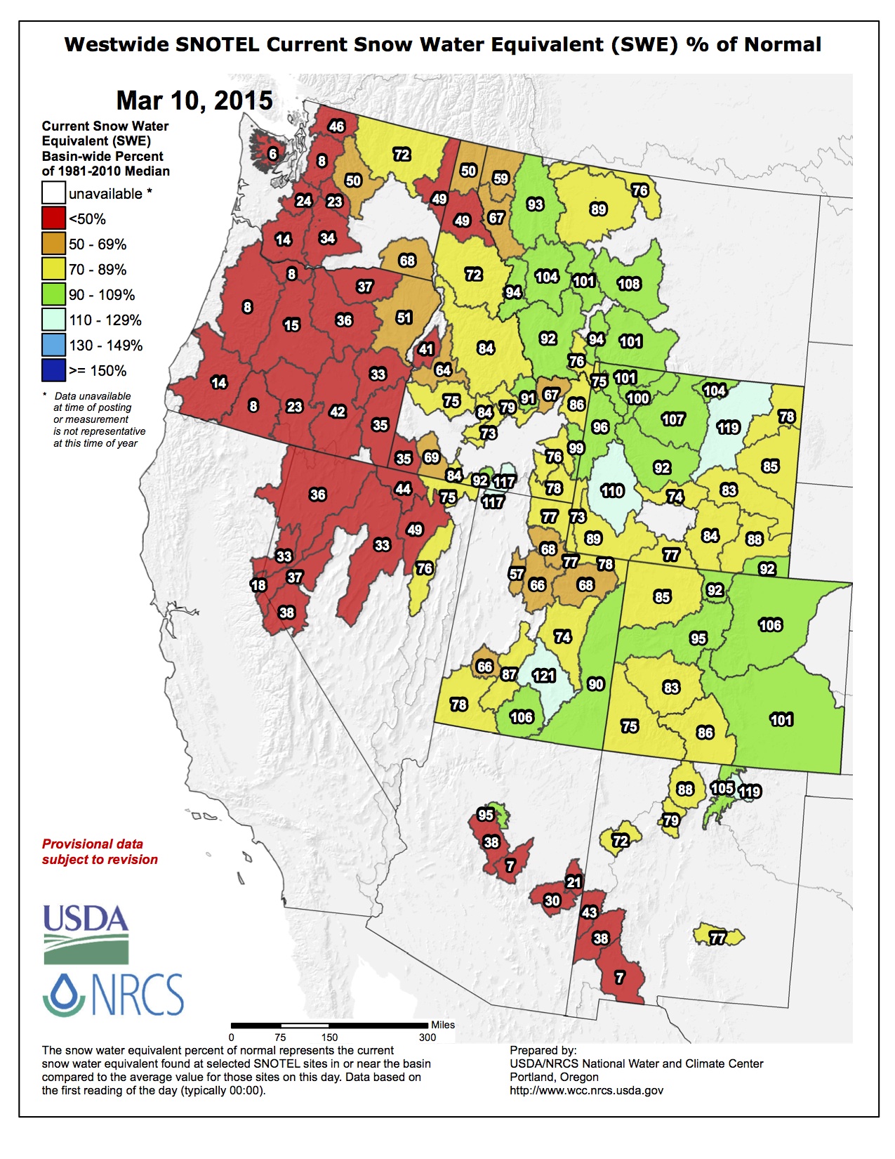
Westwide SNOTEL snow water equivalent as a percent of normal March 10, 2015 via the NRCS
From the Natural Resources Conservation Service (Brian Domonkos):
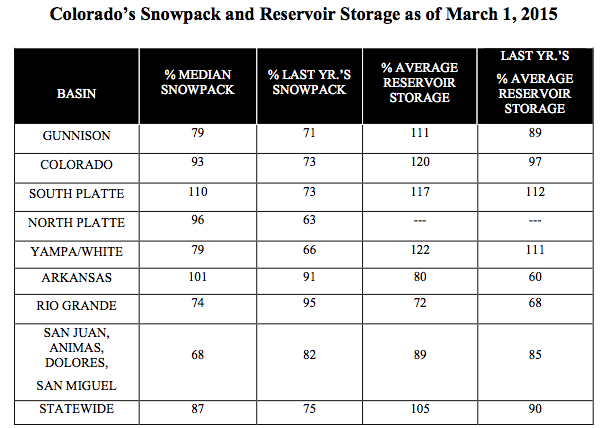
Two weeks of wet weather through the end of February and beginning of March have provided a significant increase in snowpack statewide and an even greater boost to those southern Colorado basins that are still ailing after several consecutive years of below normal snowpack. Despite substantial accumulations statewide, snowpack has not quite returned to normal, it was 87 percent as of March 1. Further investigation of SNOTEL data indicates that during the nine day period of February 20 through March 1, the state of Colorado received 2.0 inches of snow water equivalent, 181 percent of the normal for that timeframe. That is a 9 percent increase in snowpack percent of median. Preliminary numbers into March indicate an additional 7 percent increase between March 1 and March 5. On March 1, with 20 percent of the mountain snowpack accumulation season remaining, time is dwindling to close the gap and reach typical statewide peak snowpack levels. Brian Domonkos, Snow Survey Supervisor with the USDA Colorado Natural Resources Conservation Service – comments, “While not every major watershed in the state saw snowpack improvements this month, precipitation during the latter half of February was a highly beneficial to many water budgets across the state.”
The recent storm patterns were most beneficial to the Rio Grande watershed, receiving 300 percent of normal snowfall in the last 9 days of February. The South Platte and the Rio Grande both received a 13 percent gain over the course of February. In the South Platte River basin, snowpack, has not reached 2011 or 2014 levels at this point but conditions are still better than 1988, 1993, 1994 and above normal.
Statewide precipitation for the month of February was right at normal, a drastic change from 45 percent of average received during the month of January. Year-to-date statewide mountain precipitation totals increased 3 percent since last month. Colorado reservoir storage increased as well from February 1 to March 1 from 104 to 105 percent of average. Streamflow forecasts saw marked improvements most particularly for the state’s southern streams.
Brian Domonkos put the recent weather into perspective, “This storm could not have come at a better time. Without this storm, if the same weather patterns since January 1 had persisted through spring, mountain snowpack would have narrowly reached only the minimum snowpack peak.”
A March 5 report from the Natural Resources Conservation Service indicates that a two-week spell of wet, snowy weather across Colorado did wonders for the snowpack — which provides not just good skiing, boarding and sledding but water supplies for the next year. Statewide, there was nearly double the snowfall usually received between Feb. 20 and March 1. That snowfall was most pronounced in the southern mountains, coincidentally, the part of the state that most needed a good wallop of white stuff.
GOOD NEWS AT FREMONT PASS
In and around Vail, snowfall in that two-week period wasn’t as substantial as it was in southern Colorado, but the valley still received plenty. Overall, the state received two inches of “snow water equivalent.” Snow measurement sites at Vail, Copper Mountain and on Fremont Pass all received 1.5 inches or more.
That boosted snowpack totals to near, or just above, their historic averages. At Vail Mountain, the total is about 90 percent of average. At Fremont Pass, the total is 117 percent of the historic average.
Diane Johnson, communications and public affairs manager for the Eagle River Water & Sanitation District, said the Fremont Pass numbers are perhaps the most important for the district. The district provides water and sewer service to customers from East Vail to Edwards, with most of those people living west of Dowd Junction. The district can pump water from one end of the district to the other, but the Eagle River provides most of the district’s water supply. With Fremont Pass at the headwaters of the Eagle, that snow field is critical.
MELTING POINT
What’s also critical is when the snowpack starts to melt — the later the better. Early warm weather can mean lower streamflows in late summer and fall. Early warm spells can also result in flooding.
Johnson noted that spring flooding in 2010 wasn’t due to snowfall, but early, sustained warmth. There was actually more snow in 2011, but a cool spring kept flooding to a minimum.
High-elevation snow also doesn’t mean much until it melts. That’s why the U.S. Drought Monitor, a service run by the U.S. Department of Agriculture, classifies the western two-thirds of Eagle County as either “abnormally dry” or in “moderate drought.”
Wendy Ryan, of the Colorado Climate Center at Colorado State University, said while snowpack numbers improved — greatly in some areas — the drought classifications didn’t change much due to the wet weather in February and early March.
If the current stretch of warm weather holds — the forecast for Vail shows warm temperatures and only a slight chance of precipitation during the next five to seven days — Eagle County and the state might be in some trouble. Snowpack numbers still need to be climbing.
But the good news is that climate predictions contain some moisture. Ryan said that the forecast into the week of March 23 shows a good chance of above-average precipitation for most of the western U.S. The 90-day forecast also holds a decent chance of above-average precipitation.
Also, for the past couple of weeks, temperatures have cooled from the record highs seen in early February, Ryan said.
That’s what’s going to be needed.
“We hope to see an above- average March and April,” Ryan said.
While there’s still about a month left in the ski season, Johnson said she understands those who are yearning for the seasons to change.
“But we need a lot of winter still,” Johnson said. “We need the snow up high, and it needs to stick around.”
“While not every major watershed in the state saw snowpack improvements this month, precipitation during the latter half of February was highly beneficial to many water budgets across the state,” said Brian Domonkos, snow survey supervisor with the USDA Colorado Natural Resources Conservation Service.
The four SNOTEL sites in Summit County measured snowpack in the Blue River Basin on Tuesday, March 10, at 109 percent above the median.
That’s a slight drop in the snowpack percent above normal for the date compared with readings from early February.
Statewide precipitation for the month of February was normal, a drastic change from the 45 percent of average received during January.
“Without this storm, if the same weather patterns since Jan. 1 had persisted through spring, mountain snowpack would have narrowly reached only the minimum snowpack peak,” Domonkos said.
Despite the accumulations, statewide snowpack has not quite returned to normal. As of March 1, it was 87 percent of the 30-year average.
Further investigation of SNOTEL data indicates that during the nine-day period of Feb. 20 through March 1, the state received 2 inches of snow-water equivalent, or 181 percent of normal for that time frame.
That 2 inches also represents a 9 percent increase in snowpack percent of median with an additional 7 percent increase arriving between March 1 and March 5. On March 1, with one-fifth of the mountain snowpack accumulation season remaining, snow surveyors said time is dwindling to close the gap and reach typical statewide peak snowpack levels.
STATE’S RIO GRANDE WATERSHED BENEFITS
The recent storm patterns were most beneficial to the Rio Grande watershed, which received 300 percent of normal snowfall in the last nine days of February. The Rio Grande and South Platte watersheds both received a 13 percent gain over the course of February.
In the South Platte River basin, snowpack has not reached 2011 or 2014 levels, but conditions are still above normal and better than in 1988, 1993 and 1994.
Forecasters predict a chance of snow Thursday and Friday for the High Country, followed by dry, warm weather through early next week.
While Arkansas River Basin snowpack is up to 101 percent of median as of March 1, Colorado remains below normal statewide, at 87 percent of median, the Natural Resources Conservation Service reported Thursday.
Wet weather the state received for about 2 weeks in late February and early March significantly increased the snowpack, especially the southern basins, which are still having difficulties after several years below normal, the NRCS stated.
In the 9-day period between Feb. 20 and March 1, Colorado received 2 inches of snow water equivalent, which is 181 percent higher than normal for that time period. That resulted in a 9-percent increase in the snowpack percent of median.
NRCS officials said preliminary numbers indicated a 7-percent increase between March 1 and 5, but as of March 1, only 20 percent of the mountain snowpack accumulation season remains.
“While not every major watershed in the state saw snowpack improvements this month, precipitation during the latter half of February was highly beneficial to many water budgets across the state,” Brian Domonkos, snow survey supervisor with Colorado NRCS, said.
The February storm benefited the Rio Grande watershed most, which received 300 percent of normal snowfall in 9 days. The South Platte and Rio Grande watersheds received a 13-percent gain.
While statewide precipitation for February was normal, January precipitation was 45 percent of average.
The year-to-date totals for statewide mountain precipitation increased 3 percent last month, while reservoir storage increased from 104 to 105 percent from Feb. 1 to March 1.
“This storm could not have come at a better time,” Domonkos said. “Without this storm, if the same weather patterns since Jan. 1 had persisted through spring, mountain snowpack would have narrowly reached only the minimum snowpack peak.”
FromThe Grand Junction Daily Sentinel (Dennis Webb):
Recent storms have helped Colorado’s snowpack rebound from a dry January, especially in the southern part of the state.
The Natural Resources Conservation Service said Friday that the statewide snowpack was up to 87 percent of normal as of March 1, from 83 percent a month earlier.
It rose further, to 92 percent, by Friday.
The agency said that from Feb. 20 through March 1, the state received 2 inches of snow water equivalent, or 181 percent of normal over those nine days.
Brian Domonkos, snow survey supervisor with the U.S. Department of Agriculture’s Colorado Natural Resources Conservation Service, said in a news release, “While not every major watershed in the state saw snowpack improvements … precipitation during the latter half of February was highly beneficial to many water budgets across the state.”
That particularly goes for the Upper Rio Grande watershed, which during the last nine days of last month received three times the normal snowfall it gets in that time.
Southern Colorado basins have experienced several consecutive years of below normal snowpack.
The Upper Rio Grande basin had climbed to 87 percent of median on Friday, while the San Juan/Animas/Dolores/San Miguel watershed was still at 75 percent.
The Upper Colorado River Basin was at 97 percent Friday; the Gunnison, 84; the Yampa/White, 87; and the Arkansas, 103. The South Platte led the way at 112 percent of median, and the Laramie/North Platte was at 94 percent.
The conservation service said February’s precipitation was right at normal for the month, compared to 45 percent of average in January.
Statewide reservoir storage is at 105 percent of average, up a percent from Feb. 1, and the conservation service said streamflow forecasts also are markedly improved, especially in southern Colorado.
Upper Colorado River Basin reservoir storage was at 120 percent of normal on March 1; the Gunnison, 111 percent; the Yampa/White, 122; the Upper Rio Grande, 72; and the San Juan/Animas/Dolores/San Miguel, 89.
Despite the recent improvements, the Natural Resources Conservation Service noted that time is dwindling to close the remaining gap and reach typical statewide peak snowpack levels.
The start of March means that 20 percent of the mountain snowpack accumulation season remains.
April-July runoff into Lake Powell, the big reservoir in the Colorado River’s “Upper Basin”, is forecast to be 71 percent of average, according to the Colorado Basin River Forecast Center. There’s still a one in ten chance, if things get wet over the next month, that we could have an average year. But with another lost month, the chances on the wet side of the probability distribution no longer leave much room for enough excess runoff to bail out the river system’s shrinking reservoirs.
On the bad side, the “one in ten” forecast on the dry side, the worst case scenario, is for 48 percent of average.
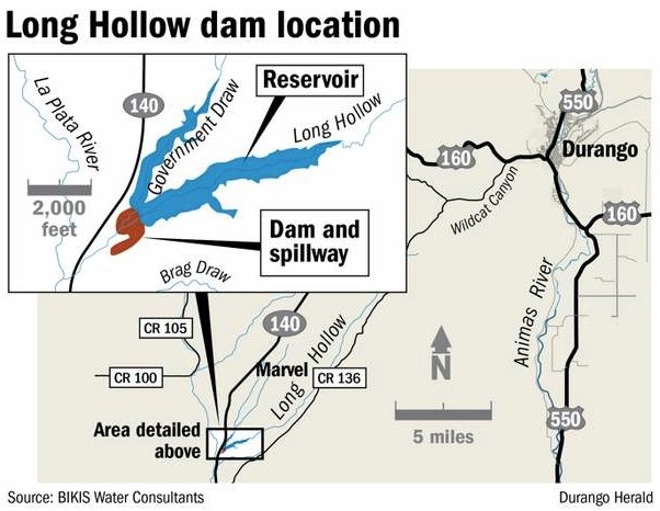
Rain and snowmelt have provided the first water for a reservoir on Long Hollow Creek near Redmesa, a long-planned storage unit that will help Colorado meet its contractual water obligation to New Mexico and indirectly provide water for irrigators in southwest La Plata County.
Construction was completed in June 2014 on the Bobby K. Taylor Reservoir, named for the late rancher whose land is now disappearing under the advancing water. When full, the reservoir will be a lake one-mile long.
Flow from Long Hollow Creek and Government Draw fills the reservoir, which has a capacity of 5,300 acre-feet.
“We had 385 acre-feet this morning,” Brice Lee, chairman of the La Plata Water Conservancy District, said Tuesday. “It’s not as much as we’d like, but we’ll take it.”
Colorado shares La Plata River water 50-50 with New Mexico, but the erratic flow makes fulfilling the obligation problematical. Now, Taylor Reservoir water can be released to the La Plata River a mile away for New Mexico consumption, and this will allow Colorado irrigators to take water from the La Plata River.
Construction of the reservoir was on a tight budget. When the Animas-La Plata Project, the last major water work in the West, was downsized in the 1990s, water for irrigation was eliminated.
Long Hollow project advocates patched together a financing plan. They acquired $15 million the Colorado Water Resources and Power Development Authority had set aside for projects in the area, got $3 million from the Ute Mountain Ute tribe and, finally, $1.6 million from the state Legislature last year.
From the Republican River Compact Administration via the McCook Gazette:
Today, reflecting the continued spirit of cooperation, Colorado, Kansas and Nebraska, along with the U.S. Bureau of Reclamation, have reached an agreement that will ensure more certainty to the basin’s water users in both Nebraska and Kansas. The agreement, signed through the Republican River Compact Administration (RRCA), was achieved through collaborative negotiations that began in January 2015 and will provide timely access to water for the 2015 irrigation season.
The agreement provides additional flexibility for Nebraska to achieve its Compact obligations while ensuring Kansas water users’ interests are also protected. The additional flexibility allowed the Nebraska Department of Natural Resources to open Nebraska reservoirs and water user’s rights that were initially limited in 2015. Opening the Nebraska water rights allowed the Bureau of Reclamation to agree to modify certain contract provisions for its irrigation districts, ensuring the availability of the water that was pumped from Nebraska augmentation projects for Compact compliance.
Additionally, the agreement allows for the Nebraska Department of Natural Resources to ensure no additional regulatory water supply reductions for Nebraska surface water irrigation user’s water supplies for the 2015 irrigation season.
Current RRCA Chairman Jim Schneider, Acting Director of the Nebraska Department of Natural Resources, said, “This is a significant step forward for the states and our water users. Our collaborative work and this agreement further demonstrate the benefits of the recent cooperation that the states have been able to achieve. I am optimistic that the states and Bureau of Reclamation can work toward ensuring these types of arrangements can be in place each year so that both Nebraska and Kansas water users will secure the benefits of having more certainty in their water supplies.”
Kansas Commissioner David Barfield said, “Today’s agreement continues to move us forward toward a longer-term solution benefiting the basin’s water users. I appreciate not only Nebraska’s continued willingness to work through these issues, but also the Bureau of Reclamation and its irrigation districts for their part in reaching today’s agreement.”
Colorado Commissioner Dick Wolfe said, “These recent agreements are emblematic of the new cooperation among the states and the federal government. I hope it continues to be a model for cooperation and successful settlement of the remaining issues within the basin.”
At the Nov. 19, 2014, meeting in Manhattan, Kansas, the states reached an agreement that provided Nebraska with 100% credit for water delivered from augmentation projects to Harlan County Lake prior to June 1, 2015, and dedicated that water to be used exclusively by Kansas irrigators.
The RRCA is comprised of one member each from the States of Colorado, Kansas and Nebraska. The purpose of the RRCA is to administer the Republican River Compact. This Compact allocates the waters of the Republican River among the three states. The next RRCA meeting is scheduled for August to be hosted in Lincoln, Nebraska.