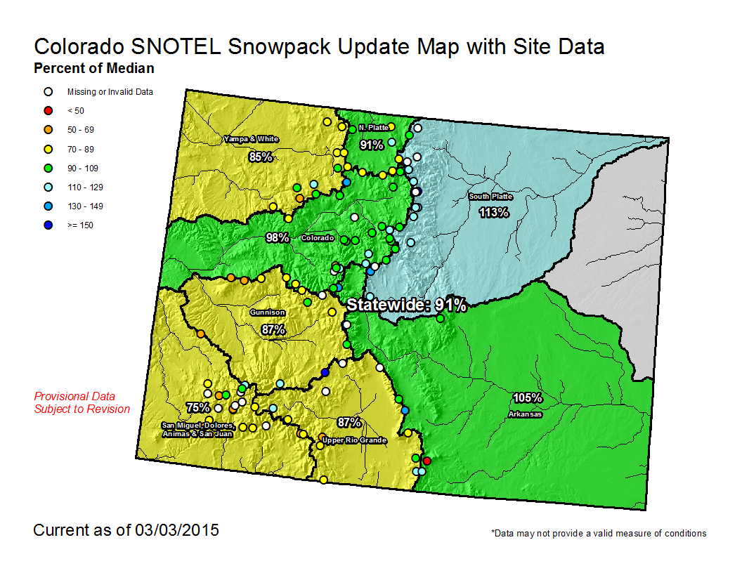
Statewide snowpack map March 2, 2015 via the NRCS

Arkansas River Basin High/Low graph March 2, 2015 via the NRCS

Upper Colorado River Basin High/Low graph March 2, 2015 via the NRCS

Gunnison River Basin High/Low graph March 2, 2015 via the NRCS

Laramie and North Platte Basin High/Low graph March 2, 2015 via the NRCS

Upper Rio Grande River Basin High/Low graph March 2, 2015 via the NRCS

San Miguel, Dolores, Animas, and San Juan Basin High/Low graph March 2, 2015 via the NRCS

South Platte River Basin High/Low graph March 2, 2015 via the NRCS

Yampa and White Basin High/Low graph March 2, 2015 via the NRCS
Click on a thumbnail graphic to view a gallery of snowpack data from the Natural Resources Conservation Service.
From the Loveland Reporter-Herald (Pamela Johnson)
Nearly 23 inches of snow fell in Loveland in February alone — 16.9 inches more than average in the typically dry winter month — and snowpack in the mountain basins that feed our water supply has increased in the past month.
“Put that with high storage levels, and we’re in pretty good shape,” said Brian Werner, spokesman for Northern Water, which manages the Colorado-Big Thompson project.
The three largest reservoirs that are part of that project, Carter, Horsetooth and Granby, contain 737,000 acre feet of water, which is the largest amount ever at the beginning of March, according to Werner. Other local reservoirs also are above average, he said.
One acre foot of water equals 326,700 gallons and is also equated to the amount needed to serve two families for one year.
March is typically the snowiest month along the Front Range, while February is thought to be one of the drier winter months.
This February alone, 22.6 inches of snow piled up in the Loveland area, which is 16.9 inches more than average in a typically dry winter month, according to Wendy Ryan, assistant state climatologist at Colorado State University. That snow brought with it 1.57 inches of water content, which is 1.05 inches above normal, Ryan reported.
For the snow season, which starts on Oct. 1, Loveland has received 44.9 inches of snow or 17.2 inches above average, according to Ryan. With that came 4.63 inches of water content, putting the area at 131 percent of average.
The mountains that feed our water supply with snow melt are split into drainages. The South Platte drainage sits at 110 percent of average while the Upper Colorado Basin moved up to 94 percent of average. And there is still the rest of March to count.
“We’re just starting March, and March and April are still our wettest months,” said Werner, adding the caveat that there are no guarantees with the weather.
“We don’t get overconfident with Mother Nature either.”
From the Fort Collins Coloradoan (Sarah Jayne Kyle):
Fort Collins got 17 inches of snowfall at the CSU weather station in February and was 10.1 inches above normal snowfall for the month, according to a monthly weather summary by Colorado Climate Center at Colorado State University.
That much snow hasn’t been seen in a Fort Collins February since 1923, when 19.7 inches of snow fell in Fort Collins. This February was the sixth snowiest February since 1889; the snowiest February was in 1911, with 25.7 inches of snowfall.
From The Pueblo Chieftain (Matt Hildner):
A storm system that’s lingered over the San Juan Mountains since Friday has dropped more than 3 feet of snow in places.
The Wolf Creek Ski Area reported 8 inches of new snow Monday afternoon, bringing the storm total to 43 inches at the ski area that sits between Pagosa Springs and South Fork.
Mountain highways running out of the valley into the San Juans — U.S. 160 over Wolf Creek Pass, Colorado 17 over Cumbres and La Manga passes and Colorado 149 over Slumgullion Pass — were under chain restrictions for all or part of Monday.
Little snowfall reached the San Luis Valley floor from the storm, but the storm was nevertheless a boon to farmers and ranchers there.
The Rio Grande Basin’s snowpack, which sat at 65 percent of average at the beginning of February, was at 85 percent of normal Monday thanks to this storm and another that came through the prior weekend.
The San Juans could see another 1-2 feet of snow along the Continental Divide through this afternoon before the storm departs, according to the National Weather Service.