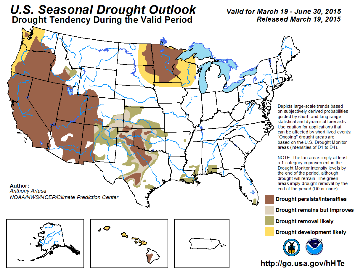


Click here to go to the US Drought Monitor website. Here’s an excerpt:
Summary
The week was characterized by drier than normal conditions across much of the Lower-48. However, there was a system that brought significant precipitation to the south and eastern part of the country. A wide swath of 2-5 inch precipitation fell in the lower Mississippi and Ohio Valleys. Across the country, temperatures for the most part were above average, as record high temperatures stretched from California eastward to the north-central U.S. In the northern Plains, departures were 20 degrees above normal. These warm temperatures began the melt season from the Great Lakes eastward into New England. Only the Deep South and extreme Northeast saw cooler than normal temperatures. Light precipitation fell in and around the Northwest, but snowpack levels remain low. Snowpack deficiencies are an even larger concern in the Sierra Nevada and Southwest mountains where the snow water content values are record or near record low levels…
Plains and Upper Midwest
Recent and long term dryness coupled with much above normal temperatures expanded D0 conditions in much of the Upper Plains. D1 conditions also expanded, occupying most of Minnesota. In Minnesota, record temperatures sped up the drying process and precipitation is 2.5 to 3.5 inches short since October 1. In the Dakotas and Minnesota, temperatures were 18-24 degrees above normal this past week. Similar anomalous conditions also led to the expansion of D0 in Nebraska. Precipitation deficits there are below the 75th percentile in most of the area. Soil moisture values in Nebraska are 2-3 inches behind normal. It was also noted that wheat broke dormancy in the McCook, Nebraska area during late February to early March. About 100 miles further east, wheat was just beginning to green up…
South and Southwest
Drought conditions in Texas were reduced in some areas, while other areas saw intensification this week. D0 and D1 conditions were trimmed back in the Coastal Bend and east Texas. Meanwhile, D2 and D3 conditions were expanded towards the south in central Texas due to the below normal reservoir levels which are less than 70 percent full in those areas.
In southwest New Mexico, the snowpack is sitting at zero percent snow water equivalent (SWE) in the Mimbres Basin, and 23 percent SWE in the Gila River Basin and 26 percent SWE in the San Francisco Basin. Based on this data, D1 was extended to the north. Across the border, D2 was extended in the Eastern Mogollon Rim and White Mountains. Further to the north in central Arizona, the snowpack melt is about 1-2 weeks ahead of schedule but Lake Mary, near Flagstaff, is at or above normal for this time of year – its highest level since 2011…
West, Northwest and Southwest
Precipitation did fall along the northern tier of the region during the week; however, aside from the highest elevations, temperatures were too warm to support much-needed snowfall. Degradation was made in Oregon and Utah due to low snowpack amounts that have plagued the west coast this past winter. Mountain snowpack across the Olympic, Cascade, Coastal Range, and Sierra Nevada is at least 25 percent below the 30-year normal. In the Sierra Nevada, precipitation amounts for the water year are 10 inches or more below normal. To exacerbate matters, average temperatures were well above normal. Temperatures in Los Angeles reached 90 degrees F for a March record four consecutive days. This just after California besting their winter (Dec-Feb) average temperature, set just last year (2013/14), by 1.5 degrees F. Washington State also had one of their warmest winters on record with an anomaly 6.0F above the 20th century average. The average temperature in Nevada, Utah, and Arizona was also record warm this past winter…
Looking Ahead
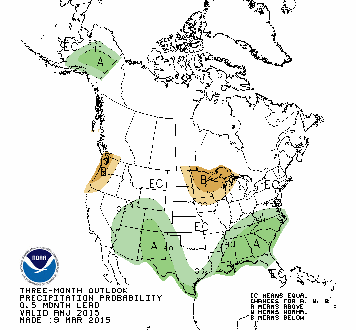
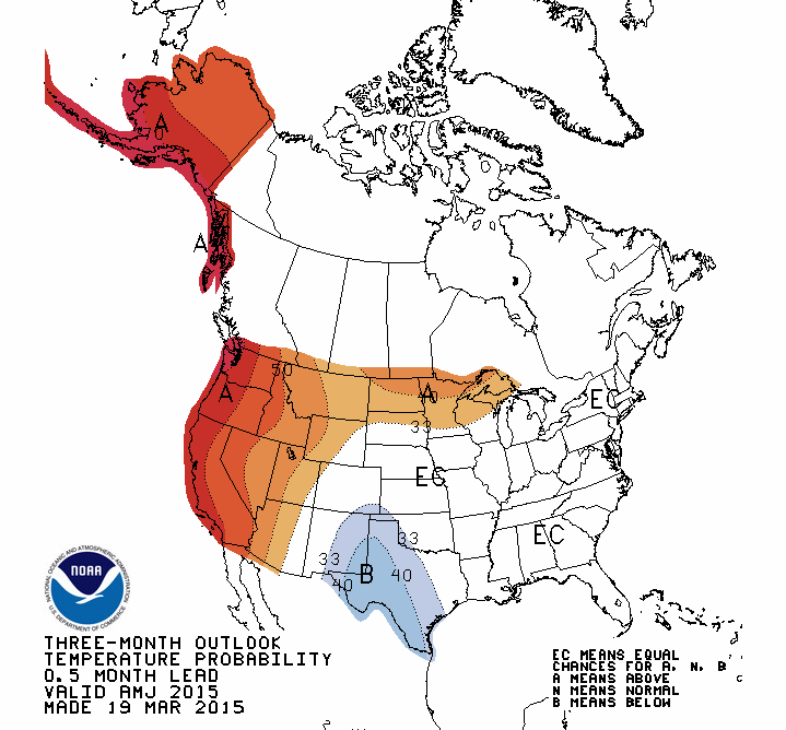
Through March 24, two low-pressure systems will track their way across the Deep South. The first system may bring upwards of 2 inches in the Southeast. The second system may bring 2 or more inches to eastern Texas and, depending on the track of the low, the Carolina Coast. To the north, more snow is expected in the Northeast as a clipper system interacts with a costal low. The heaviest snows may fall in Upstate New York and along the New England coastline. Elsewhere, two small Pacific storms will affect the Northwest during this period. For temperatures, the highest probabilities of below and above normal values are in the Northeast and Southwest, respectively.
Looking further out through the end of the month, warmer than normal temperatures continue their dominance in the West, while a series of short-wave impulses support cooler than normal temperatures in the Northeast. The Climate Prediction Center precipitation probabilities are below average for the West, Southwest and Deep South. Above average probabilities are forecasted for the Northwest, Upper Plains and East Coast.


From the Craig Daily Press (Tom Ross):
The Yampa River was clearly swollen and discolored Wednesday where it flows through downtown Steamboat Springs, and after Tuesday’s temperatures reached into the 60s, that won’t come as a surprise to valley residents.
It’s impossible to avoid noticing how rapidly snow is melting from roof tops and south-facing embankments. Aspen trees are in the earliest stages of budding in some places, and green shoots from flower bulbs are emerging weeks ahead of schedule.
The Yampa’s flows of 337 cubic feet per second Wednesday, where it passes beneath the Fifth Street Bridge in Steamboat, were more than double the median for the date, according to records kept by the U.S. Geological Survey.
In a winter of sub-par snowfall across Colorado, the west summit of Rabbit Ears Pass has been an isolated location with near-normal snowpack (water stored in the standing snow), according to monitoring by the National Resources Conservation Service.
However, there, at about 9,300 feet, the trend has reverted to unseasonably warm and dry conditions since March began with three days of welcome snowfall.
The NRCS recorded that the snowpack on Rabbit Ears March 4 stood at 94 percent of median for the date. But that number has dropped off steadily since then, losing 12 points – the equivalent of four-10ths of an inch of stored water – down to 82 percent of median for March 18. The median snowpack for March 18 is 22.2 inches and growing…
The Yampa is a tributary of the Green River where it leaves the northwestern corner of Moffat County, ultimately flowing into the Colorado in Canyonlands National Park in Utah.
Just below Craig, where the Yampa has picked up flows from the Elk River, Trout Creek, Elkhead Creek and other tributaries, the river was flowing at 1,040 cfs at midday Wednesday, compared to the median of 638 cfs.
The Elk was also flowing above the median Wednesday — 312 cfs compared to the median for the date of 152 cfs.
The Elk River Snotel, where the RCS monitors snowpack on the western edge of the Mount Zirkel Wilderness in North Routt, is currently at 69 percent of median.
From The Grand Junction Daily Sentinel (Dennis Webb):
“Other duties as assigned” may be a typical part of Americans’ job descriptions, but one of Derrick Wyle’s other duties is far from typical.
His official job is serving as a soil conservationist with the U.S. Department of Agriculture’s Natural Resources Conservation Service, assisting agricultural operators in the region out of the agency’s Glenwood Springs office. But on two days a month during the winter, he turns his attention to snow rather than soil, heading out on snowshoes to measure snowpack at a couple of area locations.
“This is collateral duty. Oh shucks, right? Two days out of every month, you have to go out and play in the snow,” Wyle said during a recent demonstration of the work on McClure Pass south of Carbondale. It was part of an educational program put on by the Roaring Fork Conservancy nonprofit group, which advocates and educates on behalf of the Roaring Fork River watershed.
While it beats a day in the office, Wyle’s snow survey duties are clearly far more work than play. As observers learned during Wyle’s presentation, the measurement process itself is fairly exacting. And then there are challenges — like Wyle once having had to dig out a buried gate during a snowmobile ride to one site, and the ever-present prospect of an emergency occurring that could require an unplanned night outdoors.
Wyle and other surveyors must undergo training including building a snow cave in case of such an event, and this soil conservationist who came to Colorado from snow-free Florida has spent the night in one, but as part of the training, not an emergency, thank goodness.
WHY IT MATTERS
The survey work Wyle and others do in Colorado and other states is part of a tradition dating back many generations, and it’s something that looks likely to continue for decades to come, even as automation is increasingly used to measure snowpack levels instead. As it turns out, a number of approaches to getting the job done exist, all with their pluses and minuses, but with the most important thing being that snowpack is accurately measured because of its importance to states like Colorado.
From skiing to rafting and other river-related recreation, to preserving fish and plant habitat and rivers as living ecosystems, “it’s all connected back to snow,” said Sarah Johnson, education and outreach coordinator for the Roaring Fork Conservancy.
Snowpack likewise has implications for agricultural, industrial and municipal water availability and use.
“The mountain snowpack is the West’s largest reservoir, and the only way we know what’s in our reservoirs, that snowpack, are these … measurements that are taken and recorded,” said Chris Treese, external affairs manager with the Colorado River Water Conservation District, based in Glenwood Springs.
Conservation service snowpack data helps in predicting winter avalanche danger and forecasting the year’s spring runoff and streamflows. It assists water managers in managing reservoir and river levels for purposes ranging from fulfilling water rights obligations and providing hydroelectric power to avoiding floods and helping endangered fish.
DOING THE FIELD WORK
Snowpack measurement has a storied history, in Colorado dating at least as far back as Enos Mills in the early 20th century. Besides leading the push for the creation of Rocky Mountain National Park, he once engaged in work as a snow observer, a job that let him spend lots of time in the backcountry he so loved.
That work is carried on in a more systematic manner today by snow surveyors like Wyle, through monthly trips to established snow course sites. Those sites are marked by signs, and surveyors walk a transect along the course, taking measurements at prescribed intervals.
“We try to hit the same point every time we go out there,” Wyle said. Consistency in measurement locations adds to the comparative value of the data being measured over time.
Surveyors work in teams of two, using up to four tubes to sample the snow. The tubes are 30 inches long each, and are screwed together to a length exceeding the snow depth.
“It’s a big (snow) year that we actually get to use all four,” Wyle said.
Surveyors are careful not to touch the metal tubes with bare hands, as that warms them up and can cause snow to stick to the inside. Tossing the tubes into the snow is a good means of cooling them off if they’re too warm.
The business end of the assembled tube has a drill-bit-like end on it. At each measurement point, a surveyor plunges the tube straight into the snow until hitting the ground, then turns the bit slightly in an attempt get a small plug of dirt to ensure the ground has been reached. If there’s no plug when the tube is removed, another sample must be taken.
With the tube still in the snow, the surveyor looks at a scale on it to read the snow depth. It’s then removed, and after digging out the dirt plug the surveyors use a spring scale to weigh the tube with the snow sample inside. The scale reads in inches of water, and after getting an initial reading, surveyors subtract the empty weight of the tube to determine the snow water equivalent.
They then can divide that number by the depth to determine the snow’s density in a percentage form. That density might be a small percentage when falling as powder in cold temperatures, and increase as the snow settles, is packed by wind, or melts and turns back into crystals.
Samples along the snow course should be within about 5 percent of each other in terms of their density, which wouldn’t normally vary greatly in the same area. If there’s a bigger difference, the surveyors know they’re doing something wrong with their measurements and need to check their work.
Slots in the tubes also let surveyors check the core inside. It’s typically not as long as the measured depth, because the snow compacts as the tube is pushed to the ground. But the core should be no less than half the length of measured depth, or surveyors will suspect a problem such as a void in the snowpack, and will measure again.
Once a measurement is completed, a surveyor can tap the tube on a snowshoe to dislodge the core (being careful not to tap with that sharp, drill-bit end), look through the tube to make sure it’s clear (but again, being careful not to do so with the business end against their eyes), pace off to the next transect point and repeat.
“Who knew this could be so …,” Carol DePaul of Carbondale, a participant in the recent tour, said after giving it a try. She didn’t complete her thought, but could have finished it with words like “precise” or “involved.” Wyle gently corrected people as they grabbed tubes barehanded, failed to get a dirt core, forgot to measure depth before removing the tube from the snow, and the list went on. There were enough opportunities to mess up during enough different steps in the process that, for fear of embarrassment this reporter rejected Wyle’s repeated offers to give it a try.
“If I was snow surveying with you I’d make you do it again because you didn’t get any soil,” Wyle teased a braver party who had just pulled the tube from the snow.
HIGHER-TECH MEANS
Still, the process isn’t rocket science, and it probably becomes second nature after enough repetition, which there’s plenty of on this job.
But not far from where Wyle was giving his demonstration on McClure Pass sits on automated snowpack measurement site that incorporates, if not rocket science, at least a little bit of space technology in its operation. It’s known as a SNOTEL, or snow telemetry, site, something that has become the mainstay of the conservation service’s snow survey program.
Key to such solar-powered sites is a pillow-like device that sits on the ground and contains antifreeze. As snow falls on it, the weight pushes some of the antifreeze out of the pillow and it rises up a measurement tube in a cylindrical room nearby. The measurement can then be transmitted by a signal that’s sent high into the sky, bounces off orbiting meteor debris and returns to Earth at a centralized data collection center.
A tower over the pillow also has a small sensor arm reaching out horizontally that can measure the depth of the snow above the pillow by ultrasonic means, based on how long it takes a signal to reach the snow and return to the sensor.
Other gauges at SNOTEL sites also take rain and temperature readings. All the readings are accessed hourly.
Yet other means have been employed to measure snow. At some locations, airplanes fly over sites containing posts of different heights. Snow depth can be determined by how many posts are visible. Density and snow water equivalent can be inferred based on readings in similar but physically accessible nearby areas.
One such site used to exist at McClure Pass, as did a manual snow course, but now the conservation service has only a SNOTEL site there.
Wyle said he thinks aerial sites tend to be found these days in places like California and the Pacific Northwest, where snow measurements may be wanted in remote, deep locations. Such coastal locations also may have 20 feet of snow, and a less-precise measurement may be less important.
A far more modern, aerial-based approach to snowpack measurement makes use of LIDAR, or Light Detection and Ranging, which is like radar, but uses a laser rather than sound. Terrain can be measured by flying overhead, then again in winter to measure the difference with snow on the ground, using highly accurate mapping.
“This is the future of snow science, snow surveys,” said Johnson, of the Roaring Fork Conservancy, noting how far things have come from the days of Enos Mills.
But that future still may be a ways off. Brian Domonkos, the conservation service’s Colorado snow survey and water forecasting supervisor, said LIDAR isn’t used at all by the service in Colorado. Wyle said it can be hazardous and expensive to have to fly all over.
“I don’t think this is going to catch on until we can do satellite-based LIDAR,” Wyle predicted.
From the Fort Collins Coloradoan (Sarah Jane Kyle):
Northern Colorado’s river basin is nearly at normal snowpack levels for the year, but still below last year’s snowpack.
The South Platte River Basin is at 96 percent of the median but only at 67 percent of 2014, which was 143 percent above normal, according to data from NRCS SNOTEL sites, which measure snowpack instantaneously.
The Cache la Poudre Basin, which is part of the South Platte River Basin and controls much of Fort Collins’ water supply, was at 103 percent above normal snowpack during a formal March 1 measurement. The same time last year, the basin was at 147 percent of normal.
During the same measurement, the South Platte was at 110 percent of normal. The same time last year, it was at 151 percent of normal.
Heavy snows in February pushed both basins — and Fort Collins proper — above average. Last month was the snowiest February in Fort Collins since the 1920s with 17 inches of snowfall, or 10.1 inches above normal, at the CSU weather station in February.
Today's snowpack water equivalent in the Colorado basin is 87% vs 2014: 128%, 2013: 77%, 2012: 68%. pic.twitter.com/2wlUXJBm79
— Matt Makens (@MattMakens) March 18, 2015
Community leaders, contractors & partners celebrated the delivery of the last pipe for the SDS project today. pic.twitter.com/rBWtOEACxv
— Colorado Springs Utilities (@CSUtilities) March 18, 2015
From The Colorado Springs Gazette (Jakob Rodgers):
The last 50-foot pipe of the 50-mile-long Southern Delivery System arrived at a construction site Wednesday, marking a key milestone for the project as it nears completion next year both on time and under budget.
“We put to rest a lot of doubters that we’d get this done,” said Lionel Rivera, Colorado Springs’ former mayor, who helped approve the project.
With Kool & The Gang’s “Celebration” playing in the background, a truck hauled the massive blue pipe to a site just south of Pikes Peak International Raceway. Crews will place it underground in the coming weeks, completing a system spanning from Pueblo Reservoir to a new water treatment facility in Colorado Springs, which is under construction.
More than 7,000 of the steel, 66-inch-diameter pipes were installed since in 2010. That included a mile-long stretch bored 85 feet below Interstate 25 – a tunnel that was $10 million cheaper than creating a surface trench, according to Colorado Springs Utilities.
Current and former elected officials from across southern Colorado, along with several contractors who have worked on the project, were among scores of people on hand to watch the pipe being delivered. Many signed their names on it.
“It’s great – we’ve been at this a long time,” said John Fredell, the Southern Delivery System’s program director. “It’s a wonderful, wonderful day to celebrate.”
Three pump stations and the treatment facility are expected to be completed this year, with the system up and running for customers in Colorado Springs by the first quarter of 2016, Fredell said.
The project is on track to cost $841 million, below Colorado Springs City Council’s approved budget of $880 million in 2009, which did not account for inflation or rising material costs. The council also serves as Utilities’ board. Those savings rise to about $150 million when factoring in the cost of inflation and increases in material costs, said Fredell, who credited design changes to the pipeline and water treatment facility for much of the savings.
From the Denver Business Journal (Cathy Proctor):
One of the biggest water projects in the western U.S. will hit a major milestone this month, when the last piece of 50 miles of pipe is laid for the Southern Delivery System, the $841 million project to bring new water supplies to Colorado Springs and nearby communities.
The project includes 50 miles of pipeline, three pump stations and a water treatment plant. It will deliver water from the Pueblo Reservoir to Colorado Springs, Fountain, Security and Pueblo West.
More than 7,000 sections of blue-colored, welded, steel pipe 50 feet long and most of it 66 inches in diameter were installed on the project during the last 3 1/2 years of construction.
The project spent $204 million on pipe and installation, according to the Colorado Springs Utilities.
“The pipe is the main artery for this water project and we are extremely pleased with how the pipeline construction went,” said John Fredell, the program director for the Southern Delivery System project.
The project is in the final year of construction and Fredell said the costs are expected to be nearly $150 million under the original budget…
Northwest Pipe (Nasdaq: NWPX), based in Vancouver, Washington, manufactured the SDS pipe at its Denver plant.
Three contractors installed the pipe, Garney Construction, headquartered in Kansas City with an office in Littleton; ASI/HCP Contractors of Pueblo West; and the heavy civil division of Layne, a construction firm based in The Woodlands, Texas, which has four offices in Colorado.
Construction is continuing on other elements of the Southern Delivery System project, including a $125-million water treatment plant and pump station that will have the capacity to treat and pump 50 million gallons of water per day. Three pump stations will help move water uphill, about 1,500 feet in elevation, from the Pueblo Reservoir, also are under construction.
Construction on the remaining portions of the project are expected to be finished by the end of 2015.
From KRDO (Rana Novini):
Community leaders gathered Wednesday to celebrate the completion of pipeline construction for the Southern Delivery System (SDS). The project consists of more than 7,000 50-foot sections of steel pipe that have been installed over the last three and a half years. The pipe will transport water stored in the Pueblo Reservoir north to Pueblo West, Fountain, Security and Colorado Springs.
“It’s taken many years and it’s taken many city councils and it’s taken many leaders and many workers to accomplish this,” said Colorado Springs City Councilman Merv Bennett. “Our friends to the south, the Lord gave them the Arkansas River as their delivery system. To the north, Denver has the South Platte River as their delivery system. We have Fountain Creek and we ran out of that water in 1912.”
Proponents of the SDS argue the pipeline will ensure Colorado Springs and surrounding areas can continue to grow, especially toward eastern El Paso County. The region will have to worry less about drought and watering restrictions.
“Water is important. It’s the lifeline of a community,” said Lionel Rivera, former mayor of Colorado Springs. “It’s the way you grow and I think we’ve ensured the water supply for at least the next 50 years.”
Rivera was mayor from 2003 until 2011 and helped get the project rolling. He said Tuesday that it was one of the most rewarding things he did as mayor.
“It’s very exciting, a little bit emotional to see that pipe,” Rivera said. “It just made me think of all the stuff we had to go through to get this approved. We were told back when we started it that it couldn’t get done from a political standpoint, but we proved the doubters wrong.”
The project has had opponents over the years, many from Pueblo who are concerned over stormwater issues.
Though pipeline construction is complete, workers still need to build water treatment plants and pump stations. The first drop of water is expected to be delivered in spring 2016.
From The Denver Post (Bruce Finley):
Construction crews are poised to lay the final pipeline link for Colorado’s biggest water project in decades — an $841 million uphill diversion from the Arkansas River to enable population growth in Colorado Springs and other semi-arid Front Range cities.
Eleven 2,000-plus horsepower pumps driven by coal-fired power plants will propel the water from a reservoir near Pueblo through a 50-mile pipeline with an elevation gain of 1,500 feet.
This is the first phase, moving up to 50 million gallons a day, for a Southern Delivery System that utility officials estimated will eventually cost $1.5 billion.
“It means we will have greater water security,” Colorado Springs utilities spokeswoman Janet Rummel said. “Businesses need water. Our communities need water to survive. It means we can continue to serve our population as it grows.”
Water challenges loom across Colorado, with state officials projecting a 163 billion-gallon shortfall. A few years ago, drought forced Colorado Springs to stop watering municipal parkways and gardens.
The diverted water can be used only within the Arkansas River Basin, officials said, ruling out sales to south Denver suburbs. And the river water, after treatment, must be returned to downstream farmers.
Colorado Springs residents have been paying for the project through water bills, which increased by 52 percent over four years. Utility officials spent $475 million from bonds.
The water will flow by next March, officials said. At full buildout, the system will store water in two new reservoirs east of Colorado Springs.

From The Pueblo Chieftain (Chris Woodka):
The Southern Delivery System pipeline’s completion was marked by a contingent of El Paso County officials and a smattering of Pueblo County folks as well.
For John Bowen, president of ASI Constructors of Pueblo West, the SDS project has meant bread on the table as well as water in the pipes.
“It’s generated $50 million in contract values for our company,” Bowen said during a ceremony to mark completion of the SDS pipeline from Pueblo Dam to Colorado Springs. “We were able to grow as a business during a time when a lot of contractors were laying people off.”
ASI was the primary contractor for the connection at Pueblo Dam, as well as 12 miles of the 50-mile SDS pipeline route, and relied on 70 local businesses for support services. The SDS project generated $800,000 in wages for ASI workers.