Farmers on the Fort Lyon Canal were shocked by news that 14,600 acres of farms on the Fort Lyon Canal were sold this week.
“The writing’s on the wall,” said Dale Mauch, a farmer who sits on the Fort Lyon board. “I’ve heard stories of three different dairies being built. If you see that happening, you know the water’s going to stay. If you don’t, we’re in trouble.”
Pure Cycle Corp. announced the pending sale of the farms to Arkansas River Farms LLC, an affiliate of C&A Companies and Resource Land Holdings LLC. C&A earlier backed a plan to pipe water from the Lamar Canal to the Front Range. Resource land has more than $550 million in assets in 25 states and Canada.
“Most people are still in shock,” Mauch said. “They’re asking, ‘When’s this company going to quit?’ They’ve got big money from back East. Is what happened to the Amity going to happen to us?”
Right now, no one can say.
Karl Nyquist, a principal with C&A, has not returned calls from The Pueblo Chieftain seeking more information about future plans. C&A is a Colorado real estate firm with residential and commercial real estate developments. But it also has 15 years of farming operations in the Lamar-Holly area, partnering with local farmer Bill Grasmick.
In 2011, Nyquist announced a plan, as GP Water, to pipe some of the water from Lamar Canal to the Front Range. Pure Cycle’s Fort Lyon farms have been targeted for dry-up so the water can be piped north.
But Mauch can see the effects of this sale.
Just 20 years ago, farms on the Fort Lyon, the largest canal in the Arkansas Valley, were selling for $700-$800 per acre (with water). When High Plains started buying farms in 2001, the price jumped to $1,500-$1,750 per acre. The latest sale raises the bar to $3,600 per acre, and there is talk that more sales are coming — up to $4,000 per acre.
“My son tried to buy a farm recently and the land was appraised at $2,500 an acre,” Mauch said. “With $4 corn and $150 hay, at $4,000 an acre? I can’t do it.”
He’s worried about the Fort Lyon after watching what’s happened next door on the Amity Canal. Tri-State Generation and Transmission purchased half of the Amity Canal beginning in 2005. He’s also worried that Main Street, Lamar, will be battered if water starts leaving the area.
Mauch believes such sales are inevitable as long as Front Range cities continue to grow.
“I can’t blame a guy for selling at this kind of money,” Mauch said. “These guys aren’t bad guys. They’re not doing anything illegal. The Front Range is going to continue to grow. It’s the way of the world. If GP doesn’t do it, the next company is going to do it.”
And what about the state water plan?
“I’d like to write the last page,” Mauch said. “Dear Governor Hickenlooper: After reading all this, here’s what it comes down to: You’ll only get the water you need at the expense of agriculture, because that’s where the water is. You only need it for growth.”
Statewide snowpack map March 23, 2015 via the NRCS
Arkansas River Basin High/Low graph March 23, 2015 via the NRCS
Upper Colorado River Basin High/Low graph March 23, 2015 via the NRCS
Gunnison River Basin High/Low graph March 23, 2015 via the NRCS
Laramie and North Platte Basin High/Low graph March 23, 2015 via the NRCS
Upper Rio Grande River Basin High/Low graph March 23, 2015 via the NRCS
San Miguel, Dolores, Animas, and San Juan Basin High/Low graph March 23, 2015 via the NRCS
South Platte River Basin High/Low graph March 23, 2015 via the NRCS
Yampa and White Basin High/Low graph March 23, 2015 via the NRCS
FromThe Colorado Springs Gazette (Ryan Maye Handy):
In mid-March, Dan Martin drove a snowcat 8 miles into the White River National Forest, headed for the place where Colorado Springs’ water supply begins. The cat lumbered along a forest service road at 10 mph, a road that Martin has driven every winter for nearly 20 years. A barbed wire fence lines the road, its wires half submerged in months of snow.
“There’s times when you can’t see this barbed wire fence,” Martin said. “To me, that’s a great year.”
Among other things, Martin measures snowpack for a living. But his time in Homestake Valley near Tennessee Pass has given him an extra snow sense. By barbed-wire fence standards, the water year for Colorado Springs is looking good.
After two years of low snowpack followed by a record-breaking year for snowfall, snowpack in Homestake Valley is solidly above average in 2015 – around 112 percent above average, based on a 30-year record. March is still winter in Colorado’s mountains, a crucial time for snowpack to keep building.
But snowpack levels are volatile – if snow doesn’t continue to fall in March and April, and if snowmelt begins too early, Colorado Springs, which gets much of its water from Homestake, could find itself facing a water deficit.
Martin monitors the snowpack closely for Colorado Springs Utilities to catch slight changes that could predict a good or bad water year.
Last winter was a record-breaking year of snowpack in Homestake Valley, but other years have been leaner. Sometimes the snow along the road is gone by spring’s end. Other times it lingers, soaking the valley until the end of summer.
“I’ve seen snow up here in August,” Martin said. “That’s probably 15 years ago, maybe. Sometimes it’s gone as soon as May. It depends on the snowpack.”
Snow in Colorado’s mountains is more than aesthetic and a blessing for ski resorts. For cities such as Colorado Springs and Aurora, snow in the White River Forest means water.
From January to April, Martin drives twice a month into Homestake Valley to take snowpack measurements, which help Utilities gauge its reservoir levels for the coming months. For Utilities customers, snowpack measurements determine watering restrictions come summer.
Water has around 200 miles to travel from Martin’s snowpack measuring tube to a faucet in Colorado Springs. It flows through Colorado River tributaries into three reservoirs, gets pumped over the mountains and is pulled pushed by gravity into Colorado Springs.
Aurora and Colorado Springs share the Homestake Water system, which conveys 70 percent of Colorado Springs’ water. Like water systems around the state, it depends heavily on winter and spring snowfall to fill its reservoirs every year.
Seeking snow
Mark Hanratty and Martin have measured snowpack for Colorado Springs and Aurora for more than a decade, and they return to the same spot every year in Homestake Valley to calculate the snow’s depth. They measure it in a drainage just off the forest service road, an area shaded by trees and where there is always snow.
“Anytime we come in here, we know we are going to have a lot of snow,” Hanratty said. The area’s wealth of moisture usually lingers for months after the mid-June snowmelt. “This is like the 9th green here in the summertime,” he added.
Mid-March is prime snow season for Colorado. The state typically receives most of its snow in March and April – no snow in late winter can signal a drought is in store.
“Springtime up here has nothing to do with when tulips and daffodils are coming up in your yard down there,” Hanratty said.
While March may leave Colorado Springs residents eager for warmth and greenery, Martin and Hanratty are praying for snow.
For their mid-March visit to the valley, Hanratty and Martin pulled their two snowcats into the drainage, covered by more than 3 feet of snow. Hanratty jumped out, sinking to his knees, with his 32-ounce aluminum snowpack measuring tube in hand. When stuck into the snow, the hollow metal tube measures the depth as well as its snowwater equivalent – there is about 1 inch of water to every foot of snow.
Hanratty tossed the tube into the snow – making sure that it was perfectly straight – and measured 47 inches of snow. The tube has to hit the dirt to get an accurate measurement. Hanratty weighed the tube and subtracted its weight from the total to come up with the snowwater equivalent of 18 ounces.
In layman’s terms, that puts the snowpack in Homestake Valley just above average. Later, a spreadsheet will translate the ounces into something more tangible – a water forecast for the upcoming summer.
While the tube measuring method might seem archaic, it is used around the West for measuring snowpack. Hanratty has no need for anything more high-tech and convenient, he said.
Crunching numbers
While Martin and Hanratty measure snowpack, Abby Ortega, a planner with Utilities, watches it through charts, graphs and data. But numbers are more than numbers to her, just as reservoirs aren’t quite as simple as they seem,
“Really I work on a spreadsheet all day,” she said. The spreadsheet tracks types of water. “You guys look at a reservoir and see a bucket of water. I see layers within that water.”
The layers depend on where the water came from, who owns it, and where it has to go. Built in the 1960s, Homestake Reservoir sits above 10,000 feet – it holds 43,000 acre-feet of water, and while it’s narrow, its depths reach 215 feet. In the winter, 4 feet of ice covers the reservoir. While good snow years come and go, there is always snow at Homestake in the winter, Hanratty said.
“The most snow I’ve seen up here was just over 7 feet,” he said.
The reservoir sits in an avalanche path – in the early 1990s, two years of avalanches destroyed an outlet hut along Homestake Dam. Some years, Utilities will hire contractors to trigger avalanches from the ridge above. Meanwhile, the hut was moved underground.
Homestake is where Colorado Springs’ water begins its journey eastward. After the reservoir, water is sent from Homestake to Turquoise Lake, then to Twin Lakes Reservoir.
Just north of Buena Vista, the Otero Pump Station pushes the water 750 feet over the mountains, and then it is pulled down the eastern side toward the Front Range. Half of the water goes to Spinney Mountain Reservoir, which feeds Aurora, while the rest travels down a pipeline to Rampart Reservoir.
Colorado Springs Utilities has been measuring snowpack in Homestake Valley since 1978, a much shorter span of time compared with the Natural Resources Conservation Service, which has been taking snow measurements around the West and in Colorado since 1935.
But the nearly 30-year span gives Utilities plenty of data to help forecast water levels for its reservoirs, which in turn determine water use for months and years. Monitoring snowpack levels in Colorado’s mountains is crucial for Front Range cities and for all of the 18 states downstream, to the east and the west, where Colorado’s rivers flow.
Four major rivers flow out of the state, including the Platte, the Arkansas and the Rio Grande, but the Colorado River, with its headwaters in Rocky Mountain National Park, is perhaps the most endangered. The river feeds California but it also provides water to the Arkansas River Basin, home to Colorado Springs, and feeds the reservoirs in the Homestake System.
Unlike other Front Range cities, such as Fort Collins, Colorado Springs is not near a major river, and relies instead on tributaries and recycled water to feed its water reserves, said Ortega. Having water storage is key to helping Utilities to weather a drought.
“If you can leverage those wet years with storage, you can ride through the dry years,” Ortega said.
Reservoirs are difficult to construct and even more difficult to get approved, since environmental regulations have tightened since the 1960s.
While Utilities may not add another reservoir, it is looking to the Southern Delivery System to offset stresses – population growth, drought and other system outages – on its existing system.
The Southern Delivery System is a regional project to bring Arkansas River water from the Pueblo Reservoir to Colorado Springs, Fountain, Security and Pueblo West. The project is expected to deliver water beginning in 2016.
“That pipeline is going to be our water supply,” Ortega said.
From the Associated Press via the Fort Collins Coloradan:
The bill allows homeowners to collect up to 110 gallons in rain barrels.
Colorado’s rain-barrel ban is little known and widely flouted, with rain barrels for sale at many home-gardening stores and commonly used by home gardeners.
But the barrels technically violate Colorado water law, which says that people don’t own the water that runs on or through their property. They can use the water, but they can’t keep it.
Colorado’s law banning rain barrels was amended in 2009 to allow use by people with their own wells. But the change didn’t apply to municipal water users.
The measure addresses what some believe to be an antiquated prohibition on collecting and storing rainwater from roofs in Colorado.
“Colorado is the only state where it is illegal to collect and use rainwater,” said Rep. Daneya Esgar, D-Pueblo, who co-sponsored the bill. “I’m glad to see so much bipartisan support for this common-sense bill.”
The measure was amended to allow individuals to keep rain from their roof in up to two 55-gallon rain barrels for use in their garden or on their lawn. The bill started at two rain barrels with a combined storage of 100 gallons, but lawmakers decided to slightly raise the number.
Sponsors pointed out that an estimated 97 percent of water that falls on residential property never ends up in a river or stream system.
But critics say the measure would steal water rights from downstream users. They say water does not belong to someone simply because it fell on a roof. Instead, the water is return flow that someone downstream has a right to, especially if that water is being stored, say critics.
Republican Reps. Don Coram of Montrose and J. Paul Brown of Ignacio both voted against the measure. Coram said the bill serves as a literal slippery slope, suggesting that what starts as roof collection could end in allowing Coloradans to collect rainwater off their entire property.
“We keep nibbling away on the prior appropriation doctrine, and you know you eat an elephant one bite at a time,” Coram said, referring to the system in Colorado in which water rights are granted to the first person to take water from an aquifer or river, despite residential proximity.
“I object more to changing the process,” Coram added.
The bill would also set standards for rain barrels, including mandating screens to filter out debris and insects.
Sponsors estimated that with two 55-gallon barrels, residents cold capture more than 600 gallons of water each year.
Environmental groups praised the bill as another step towards conservation.
“While the amount of water saved is modest, having rain barrels in yards around the state will serve as an important tool to increase Coloradans’ knowledge of our limited rainfall and water supply,” said Pete Maysmith, executive director of Conservation Colorado. “This common-sense step should help people understand the need for smart water conservation policies.”
In the 1894 hit song “Playmate, Come Out and Play With Me,” the rain barrel is forever lodged in our collective consciousness right between the apple tree and cellar door.
But Colorado has waited 121 years since then for the use of rain barrels to become legal.
On Monday, the state House took the first step toward legal rain collection with the passage of HB1259, which would allow collection of up to 110 gallons in two 55-gallon drums. The bill passed 45-20 and now heads to the state Senate.
“Colorado is the only state where it is illegal to collect and use rainwater,” said state Rep. Daneya Esgar, who co-sponsored the legislation. “I’m glad to see so much bipartisan support for this common-sense bill.”
She sponsored the bill after hearing people talk about rainwater collection.
“It makes more sense to collect the water and use it when it’s needed,” Esgar said. “Really, the purpose is to get people to talk about water use and to be conscious of it.”
Colorado’s ban on rain barrels can be traced back to the state constitution and subsequent court cases that prohibit any sort of detention of water upstream from a senior right. It’s the same concept that poses a dilemma when considering flood detention structures.
Has the rain-barrel ban been rigorously enforced?
“Not that I can recall,” said Division 2 Engineer Steve Witte. “I would say it’s been rarely enforced. If people ask, there is a policy on (the Division of Water Resources) website.”
A 2009 state law (SB80) authorized the use of rain barrels in connection with other water rights. Another 2009 bill (HB1129) authorized pilot projects for rainwater harvesting. So far, the proposed Sterling Ranch development in Douglas County has been the only applicant.
HB1259 would allow any single-family residence or multifamily residences with four or fewer units to collect rainwater. Rainwater could only be used on lawns or in gardens, and would not be allowed as drinking water or for any other indoor uses. Barrels also would be required to have a sealable lid.
Opponents of the bill said it opened the door to other forms of capturing water before it reaches downstream users. Supporters argued that 97 percent of the water on residential lots never makes it into the stream system anyway.
If the rain-barrel law passes, homeowners will have a new source of water for that apple tree, while keeping rain from sliding down the cellar door.
Click here to go to the Colorado Water Conservation Board website to read the update. Here’s an excerpt:
Activation of the State Drought Mitigation and Response Plan, and the activation of the Agricultural Impact Task Force remain in effect to respond to ongoing drought conditions in Southern Colorado.
February was the 14th warmest on record and 221 daily temperature records were either tied or broken throughout the state. March has continued this pattern especially on the western slope. At least two communities, Denver and Colorado Springs have seen their earliest 80oF day on record (March 16). Late February and early March storms helped increase snowpack levels, but the remainder of the month, to date, has been warm and dry in many basins.
El Nino conditions are expected to strengthen over the next few months favoring a wet spring for the southeastern portion of the state.
Water year-to-date precipitation at mountain SNOTEL sites, as of March 16, is at 85% of normal. As a state, Colorado will need to experience 226% of normal precipitation in the next few weeks in order to reach the normal peak by April 1st. The South Platte basin continues to have the highest snowpack at 100% of normal. The Upper Rio Grande basin has the lowest at 73% of normal, a 12% increase from February.
March 1st streamflow forecasts statewide range from 54-113% of average. The near average to above average forecasts are in the South Platte, Colorado, and upper portions of the Arkansas and Rio Grande basins. The lowest streamflow forecast is 54% of average in the upper Gunnison basin on Surface Creek at Cedaredge.
Reservoir Storage statewide is at 105% of average as of March 1st a slight improvement from last month. Storage in the northern half of the state is in good shape heading into the spring. The southern half of the state has below average storage levels. The Upper Rio Grande has the lowest storage at 72% of normal.
The Surface Water Supply Index (SWSI) is at near normal statewide. The lowest SWSI value in the state is due to low storage levels in Paonia Reservoir in the Gunnison basin. Currently, the reservoir is at 25% of average.
Current El Nino conditions are expected to persist and may be bolstered by a positive PDO (Pacific Decadal Oscillation). El Nino typically favors more precipitation in Colorado during the growing season.
Water providers in attendance reported their systems are in good shape, largely due to plentiful storage. Despite higher than average temperatures, providers have not seen a significant increase in customer demand.
More Colorado Water Conservation Board coverage here.
With the end of snow season in sight for Colorado’s high country the statewide snowpack continues to struggle.
As of March 20 it was 81 percent of normal, down from 92 percent on March 6.
The average peak for snow accumulation in Colorado’s mountains is April 9.
While we’re in much better shape than some of our neighbors to the west, we know all too well how fast things can change when the weather patterns shift.
Colorado is a land-locked state about 1,000 miles from the nearest source of atmospheric moisture and it depends on weather patterns to bring rain and snow.
The latest information from the U.S. Drought Monitor shows that 51 percent of the state was in a drought as of March 17.
That’s up 30 percent from just three months ago.
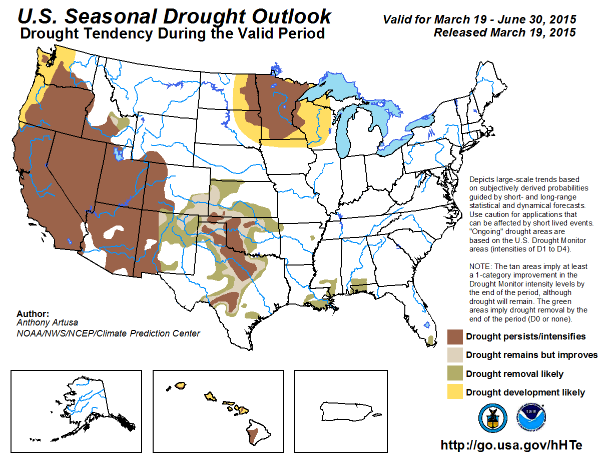
The latest 90-day outlook from NOAA’s Climate Prediction Center provides hope for the state with a wetter-than-normal forecast.
For Colorado to reach peak snow accumulation by the normal date we’ll need a few slow-moving and soggy storm systems to materialize quickly in the high country.
SNOTEL data shows that precipitation would need to be 293 percent of normal to reach peak accumulation by April 9.
Flood irrigation — photo via the CSU Water Center FromThe Grand Junction Daily Sentinel (Charles Ashby):
he Colorado Senate gave final approval Tuesday to a water bill that made some Western Slope lawmakers a bit uneasy.
The measure, [SB15-183], requires water court judges, when considering changes in water uses, to decide based on actual historical use of that water, rather than uses not approved by a prior water decree.
Several Western Slope lawmakers from both parties questioned why such a bill would be necessary, saying it allows water rights owners who use water for unapproved purposes to get away with that illegal use.
“We have water courts for a reason,” said Sen. Ellen Roberts, R-Durango. “Water courts are highly trained to deal with technical issues. This bill basically is skipping over the water courts system and coming here to the Legislature to try and get a legislative result, as compared to having it well considered in the court system that, again, is trained to deal with these kinds of things.”
Supporters of the measure said the bill is designed to give direction to water court judges based on a recent Colorado Supreme Court decision in a case between Dick Wolfe, the state’s water engineer, and the Sedalia Water and Sanitation District over the district’s historical use of water.
Rep. Jerry Sonnenberg, R-Sterling and a sponsor of the bill, said it’s the Legislature’s job to give direction to the courts when there is undefined law on an issue.
“The question here is, do we want a consistent use of water, a consistent means of determining what the volume or quantity of that water is, as the Supreme Court did in the Sedalia case?” Sonnenberg said. “That’s what we’re trying to do, is clarify what they have asked us (about) what should and should not be used in quantifying a water right in a change of use.”
Sen. Kerry Donovan, D-Vail, said the bill rewards water users who use that water for unapproved uses.
The bill has support from virtually every water group in the state except the Colorado River Water Conservation District.
In the end, only eight senators voted against the bill, including Donovan, Roberts and Sens. Ray Scott, R-Grand Junction, and Randy Baumgardner, a Hot Sulphur Springs Republican whose district includes Garfield County. It now heads to the House for more hearings.
In a related matter, the House approved a water bill Tuesday that allows the Colorado Water Conservation Board to acquire water rights for up to 12 pilot projects to measure efficiency savings for instream flow use.
The pilot projects would take at least 10 years to complete.
Montezuma Valley FromThe Cortez Journal (Tobie Baker):
Addressing less than 10 people at the Four States Ag Expo on Saturday, March 21, Colorado Representative J. Paul Brown said his top legislative issue was water storage. He’s introduced HB 1157, a bill to study water storage on the South Platte River.
A member of the House Agriculture Committee, Brown said the bill had received broad support, even from environmentalists. He added that sending water from the state’s Western Slope via transcontinental diversion had to be addressed. Since 2010, 2.5 million acre feet of water has been sent out of state on the South Platte River, Brown said.
“We don’t have anymore water to send down,” the District 59 representative proclaimed.
Much of the American west has experienced drought-like conditions in 11 of the past 14 years. Scientists have warned the area could be entering a 35-year mega drought.
“I keep hoping that we’re getting out of the drought,” said Brown. “I’m an eternal optimist. You have to be as a farmer.”
A life-long sheep rancher in Ignacio, Colo., Brown said the worst drought he experienced came in 2002.
“We don’t know what’s going to happen in the future, but storage is the answer,” said Brown.
Brown added the agriculture committee had received lots of water concerns. He explained a balance was necessary between demands from environmentalists calling for more in-stream flow regulations, for example, and agriculture needs.
“Agriculture is the second leading industry in state at $40 billion,” said Brown. “That’s why we need to store water on the South Platte.”
During the informal agriculture summit discussion, one man questioned Environmental Protection Agency actions.
“The EPA wants a complete power grab,” responded Brown.
Indicating the federal government would control water collected in potholes if they could, Brown said the state would have to be remain vigilant against additional regulations and oversight.
“When they control water, then they control you,” Brown warned.
Seven-point draft conceptual agreement framework for negotiations on a future transmountain diversion screen shot December 18, 2014 via Aspen Journalism
[ed. I’m reposting this with the link and story from the Aspen Journalism site. Brent has included a bunch of audio from the recent Basin Roundtable Summit.]
The prospects for a potential new transmountain water diversion that would bring more water to Colorado’s growing cities on the Front Range appeared to brighten recently during a meeting of about 300 Colorado water leaders.
At the meeting, held in Westminster on March 12, members of the state’s nine river basin roundtables responded in near unanimity to a straw poll regarding a “draft conceptual framework” that outlines how to keep discussing, and planning for, a new transmountain diversion, or TMD.
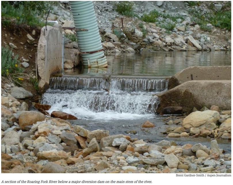
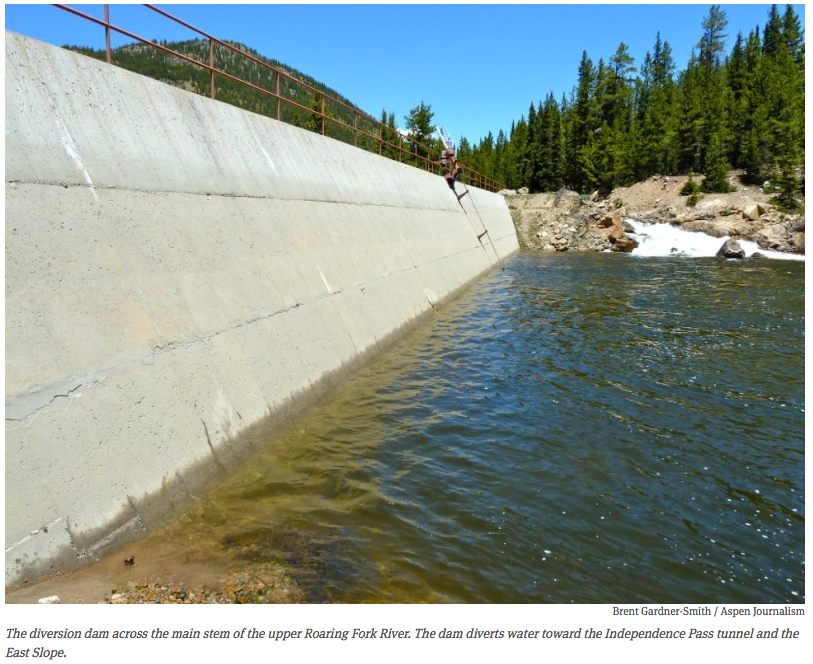
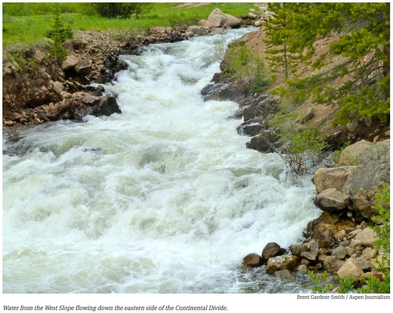
Today in Colorado, between 450,000 and 600,000 acre-feet of water is diverted under the Continental Divide from the west to the east slope. To put that in context, Ruedi Reservoir holds about 100,000 acre-feet of water and the total annual flow of the Roaring Fork River is about 900,000 acre-feet of water.
All but five of the approximately 300 people gathered in a Westin hotel ballroom gave a thumb’s up to a list of statements regarding ways to look at a potential new TMD.
“We have consensus on all of these points, but not necessarily that they’re fully encompassing,” said Jacob Bornstein, a program manager at the Colorado Water Conservation Board who has been helping to develop the draft conceptual framework and who lead the straw poll exercise.
The 7 points
Often referred to as “the seven points,” the conceptual framework has been the subject of much discussion over the past six months among members of the nine basin roundtables, who came together on March 18 for a “statewide basin roundtable summit.”
“As you’ve heard from every corner of the state, everyone has at least begun to consider the usefulness of this conceptual framework,” said John McClow, a CWCB board member who also sits on the Gunnison River basin roundtable. “I think we’ve heard from all of them that it might need some definition, it might need some refinement, but that it will provide us with a framework that we can utilize to evaluate a future TMD.”
However, roundtables on the West Slope, especially the Gunnison, Yampa-White and Colorado river basin roundtables, are still voicing concerns and questions about the conceptual framework and the harm a new TMD might cause.
Despite the concerns from the West Slope, James Eklund, the director of the Colorado Water Conservation Board (CWCB), the state’s water-planning agency, opened the roundtable summit on a bullish note.
“Whether you call them the draft conceptual framework, or the seven points of consensus, or the conceptual agreement, or the guidance on interbasin negotiations, or my personal favorite, the seven points of light, the work of our leaders in this room and on the Interbasin Compact Committee demonstrates the new paradigm in East-West discussions,” Eklund said.
The CWCB’s 27-member Interbasin Compact Committee includes representatives from each of the roundtables, as well as members appointed by the governor and legislative representatives.
The group unanimously endorsed the conceptual “seven points” last July.
The enviromental perspectives
Melinda Kassen, an attorney who specializes in environmental issues, has served as a governor-appointed environmental representative on the IBCC since 2005.
“So, I think I was asked to come up here to justify my having raised my thumb on this, when we did this last summer,” Kassen said as she addressed the crowd in Westminster.
Kassen said she could support the framework because of its seventh point, which states, “Environmental resiliency and recreational needs must be addressed both before and conjunctively with a new TMD.”
“The reason that this point is so important is the way it’s written,” said Kassen, noting the point about the environment was last on the list, but not least.
“It doesn’t say we will address environmental and recreational needs in the context of some big new transmountain diversion,” Kassens said. “It doesn’t say we’ll do mitigation and that’s how we’ll deal with the environment. What it says is, we will make our environment resilient now. We will protect our recreation economy now. And then, if at some point in the future if there’s another big project, we will also do mitigation for that project.”
The Front Range perspective
Jim Lochhead, the CEO and General Manager of Denver Water, also spoke at the roundtable summit.
“In terms of a future transmountain diversion, that is an option that needs to be preserved for the future, if we need to do it,” Lochhead said. “But what this conceptual framework does is articulate some principles that we can agree to, that allows us to move forward when and if that time comes.”
Lochhead also stressed the importance of entities on the West Slope and Front Range working now on the things it can agree on, instead of just listing long-standing disagreements.
“Let’s be more efficient,” Lochhead said. “Let’s work on re-use (of water). Let’s work on capturing and using local water supplies as efficiently as we possibly can throughout the entire state, across all sectors, before we begin talking about big infrastructure projects that, hopefully, we either don’t need or we need at a much smaller and refined scale in the future. But when and if we do need those, they will be developed in partnership across the entire state.”
He also stressed that the seven points need to be viewed as a whole package.
“There’re not in any kind of order,” Lochhead said. “They are not even individual pieces, they are a package. They need to be viewed as a whole, because they are a part of a whole. And they are part of a commonality, I think, that we agreed on, and that we should agree on, in terms of where we’re going as a state.”
The view from the roundtables
After Kassen and Lochhead spoke, the CWCB’s Bornstein took the room through the straw poll, where members could vote thumbs up, down or sideways.
As he went through a reversed, and re-worded list of the seven points (see below), there was not one “thumbs down.”
Then Bornstein put up a slide referring to all of the seven points, or statements, which read: “These previous statements encompass the major issues a conceptual framework on a new TMD should address, although more detail may be needed.”
“We’ve got … five people in the room, out of about 300, that think these are not the major issues,” Bornstein said.
After that, a panel of representatives from four roundtables shared the current view of their respective roundtables about the seven points.
Joe Frank, the general manager of the Lower South Platte Water Conservancy District, is serving as the new chair of the South Platte River basin roundtable.
He said the members of the South Platte roundtable had previously voted unanimously to support the “seven points.”
And on March 10, the South Platte roundtable also agreed to include a “straw man” TMD in the its basin implementation plan, so that a theoretical new TMD – such as a pipeline to move water to the Front Range from Flaming Gorge Reservoir – could be freshly analyzed in the context of the seven points.
“The framework is in a good spot, but moving forward past that we need to get a straw man and discuss these difficult topics,” Frank said.
The South Platte roundtable is also strongly in favor of building new water reservoirs in the state and it wants storage discussed in the forthcoming final Colorado Water Plan, which is open for public comment until May 1.
“We just believe that storage needs to be front and center when we start to talk about Colorado’s water,” Frank said. “We’ve heard it a lot that conservation needs to be the beginning of the conversation, we also believe that storage needs to be in the beginning of that conversation.”
The Arkansas roundtable’s view
James Broderick, the executive director of the Southeastern Water Conservancy District, sits on the Arkansas River basin roundtable.
He said the Arkansas roundtable also believes new storage should be an integral part of the state’s water planning efforts, and that the Arkansas roundtable supports the seven points as written.
“From an Arkansas perspective, we’re not sure what all the controversy was about,” Broderick said.
The west slope’s view
The views presented at the statewide summit by two West Slope roundtables were quite different, however.
“We think the framework has questions that need to be answered before there can be something called an agreement, particularly about any transmountain diversions moving forward,” said Jon Hill, a Rio Blanco County commissioner who sits on the Yampa-White basin roundtable.
Hill said it was important to the Yampa-White river basins that an understanding be reached that sets aside some level of future water development in the region, which remains largely undeveloped.
“As long as we can work it in that we have some increment of future use, that is going to be reserved, or however you want to call it, then we can start getting along on this and that,” Hill said.
Michelle Pierce, the chair of the Gunnison River basin roundtable, said that while she feels the seven points represent a breakthrough of sorts, they shouldn’t be included in the state’s forthcoming water plan.
“I was at that meeting where these seven points were brought up and developed, and I did think it was a huge breakthrough in this process,” Pierce said. “It’s taken, up to that point, nine years to even talk about transmountain diversion. So I thought that was huge.”
However, Pierce went on to say, “the Gunnison basin doesn’t believe that the conceptual framework is ready for inclusion in the state plan. If it is determined that it will be included in the state plan, we would like to see a big disclaimer with that, something that would say, or highlight the fact that it is still under discussion, it still needs refinement, and that there is no real agreement statewide as to what those terms mean.”
A Colorado River basin view
A representative from the Colorado River basin roundtable was not included on the same panel at the March 12 summit with the representatives from the Gunnison, Yampa-White, Arkansas and South Platte roundtables, but the Colorado roundtable is on the record as opposing the inclusion of the seven points in the water plan.
On March 5, at a public meeting of the Roaring Fork Watershed Collaborative, Louis Meyer, a veteran Colorado roundtable member and a principal engineer with SGM, an engineering firm in Glenwood Springs, strongly criticized the seven points.
“I think that these were written on behalf of the Front Range, not the West Slope,” Meyer said. “I think if the West Slope’s four basin roundtables wrote them, they would be very, very different.
“There is no extra water in the state of Colorado,” Meyer said. “What we’re talking about is a reallocation of the water we already have. So, what is this re-allocation going to be? It is going to be a reallocation of water from agriculture and healthy rivers to rooftops and nonnative turf grass on the Front Range. I believe that the result will be flat rivers, the loss of agriculture, and escalating water costs.”
“The 7”
Here are the seven points as presented by the CWCB’s Jacob Bornstein during a straw poll at the statewide roundtable summit.
Bornstein said this list, which differs in order and in the wording from the official version of “the seven points,” also listed below, was “a bit of a deconstructed look at the conceptual framework.”
“Because I’ve been going to every roundtable, almost, and helping to explain this, I’ve sort of learned how to not have the eyes cross when you are talking about some of these concepts,” Bornstein said, noting he now simply calls them “The 7.”
1. We need to address environmental resiliency and recreational needs, including the recovery of imperiled species, with or without a new transmountain diversion (TMD).
2. If a new TMD were to be built, the proponent should involve non-consumptive, environmental and recreational partners upfront, so that the project is designed with environmental and recreational needs in mind, incorporates benefits, and mitigates impacts.”
3. Colorado should continue its commitment to improve municipal conservation and allowable reuse, statewide, with or without a new TMD.
4. If a new TMD were to be built, West Slope needs should be accommodated as part of a package of projects and processes that benefit both East and West slopes.
5. Colorado should develop a collaborative program aimed at preventing a (Colorado River basin) compact curtailment issue from occurring, while protecting existing users from involuntary curtailment (e.g., eminent domain or strict administration).
6. The collaborative program (in point 5) should be voluntary, such as a water bank and other demand management programs, and aimed at protecting current Colorado River water users, and some increment of additional use yet to be defined, but NOT uses associated with a new TMD.
7. If a new TMD were to be built, it would not guarantee delivery of a certain amount of water annually, but instead operate as part of a flexible optimized system, diverting only when water is available, based on triggers Colorado establishes in advance, and relying on East Slope sources of water when not diverting.
At the end of the meeting, Bornstein put up one more statement, which read: “If the feedback from today is incorporated into the conceptual framework, then it is headed in the right direction.”
“No thumbs down,” Bornstein said after surveying the room. “So wonderful, thank you.”
The “original” 7 points
Here are the seven points as originally endorsed upon by the IBCC last year:
1. The East Slope is not looking for firm yield from a new TMD project and would accept hydrologic risk for that project.
2. A new TMD project would be used conjunctively with East Slope interruptible supply agreements, Denver Basin Aquifer resources, carry-over storage, terminal storage, drought restriction savings, and other non-West Slope water sources.
3. In order to manage when a new TMD will be able to divert, triggers are needed.
4. An insurance policy that protects against involuntary curtailment is needed for existing uses and some reasonable increment of future development in the Colorado River system, but it will not cover a new TMD.
5. Future West Slope needs should be accommodated as part of a new TMD project.
6. Colorado will continue its commitment to improve conservation and reuse.
7. Environmental resiliency and recreational needs must be addressed both before and conjunctively with a new TMD.
Editor’s note: Aspen Journalism, The Aspen Times and the Glenwood Springs Post Independent are collaborating on coverage of water and rivers. The Times published this story on Saturday, March 28, 2015.
The runoff forecast into McPhee Reservoir has some good news and some bad news.
As of March 13, snowpack in the Dolores basin was 80 percent of normal. But if no more snow falls by April, then the irrigation supply in McPhee is expected to be about half, said manager Mike Preston.
“More moisture in the next few weeks is critical,” he said.
At the current snowpack level, full-service irrigators are only expected to receive about half their allocated water – 11 inches per acre. When the reservoir fills, full-service irrigators receive 22 inches.
Farmers received 20 inches last year, thanks in part to monsoon rains in summer and fall. In 2013, a very dry year, farmers received 6 inches, or 25 percent of their normal amount if the reservoir fills.
On the brighter side, the National Resource Conservation Service forecasts a 7-in-10 chance that McPhee will fill to 81 percent of capacity. At that level, full-service irrigators would be delivered 20 inches of water per acre.
“Even if there is no more snow, we are better off than 2013,” Preston said. “We’re still speculating. The uncertainty is what happens between now and April.”
It’s questionable whether the reservoir will fill to capacity; NRCS gives it a 50-50 chance.
Because of limited snowpack, there will be no whitewater boating season this year for the Lower Dolores, officials said. A whitewater release below the dam last occurred in 2011.
Narraguinnep Reservoir is almost full, and Groundhog Reservoir has 9,000 more acre-feet than this time last year.
Fen photo via the USFS FromAgri Pulse (Philip Brasher):
The Obama administration is promising to rewrite its proposed Clean Water Act rule to ensure that farmers have clear guidance about what streams, ditches and ponds will be regulated.
Speaking to the National Farmers Union annual convention in Wichita, Kansas, EPA Administrator Gina McCarthy said the final rule is being prepared for White House review, and that the administration still intends to complete it this spring.
EPA and the Army Corps of Engineers are working to tighten the definitions of ditches, tributaries and farm-field erosional features to narrow what areas fall under the law’s jurisdiction as “waters of the United States” (WOTUS), she said.
“We are going to come out with a rule that is not only reasonable but implementable,” she said.
The final rule will be accompanied by extensive guidance in a question-and-answer format that will include photographs to make it easier for farmers to understand what areas of their land might be regulated, she said.
“You will have a catalog of your questions answered by putting together real-life things that you’re doing on your farms and ranches,” she said.
The National Farmers Union, unlike the larger American Farm Bureau Federation, was initially supportive of the proposed rule when it was released a year ago but later began to raise concerns as well. In comments filed last fall, NFU pressed EPA to rewrite the definitions to make clear that the agency would not increase the law’s jurisdiction. NFU is scheduled to debate its policy positions on Tuesday.
McCarthy told the group that the administration had bungled the rollout of the rule and should have called it the “Clean Water rule” rather than WOTUS. “Even if we had a less-than-ideal start, that doesn’t preclude us from getting this done right,” she said.
She offered no specifics about the revised language. But she said the final rule would make clear, for example, that erosional features in a farmer’s field would be exempt and that the agency was considering rewriting the definition of “upland ditches” to make it less confusing.
Officials also are “thinking through ways to be more specific” about the definition of “other waters,” which includes wetlands, a critical issue in the northern Plains, she said.
She said the definition of tributary would be made clear that the rule would only cover “natural or constructed streams – the ones that could carry pollution downstream-which have to have the amount, duration and frequency of flow to look, act, and function like a tributary. They are the ones that we don’t want to pollute or destroy without thinking about how to mitigate impacts downstream.”
Greg Hobbs at the Colorado Water Congress January 2012
Colorado Columbine photo via Greg Hobbs
Hobbs’ family hike
Flood irrigation in the Arkansas Valley via Greg Hobbs
David Robbins and J.C. Ulrich (Greg Hobbs) at the 2013 Colorado Water Congress Annual Convention
Dick Bratton, Greg Hobbs, im Pokrandt
Peter McBride and Greg Hobbs at CFWE Colorado Water 2012 event
Greg Hobbs, Diane Hoppe
Greg Hobbs and Coyote Gulch at Colorado College State of the Rockies Speaker Series 2011
Bents Fort photo via Greg Hobbs
Will Hobbs, Greg Hobbs, Dan Hobbs, and a string of fish for dinner, Mary Alice Lake, Weminuche Wilderness, 1986 via Greg Hobbs
Justice Hobbs is a friend of Coyote Gulch. Over the years I’ve published a small portion of his poems including photo poems that he’s written in the recent past. On the occasions where I’ve had an opportunity to talk with him at some length I’ve learned the depth of his life experience — he has travelled, written, and learned about the world around him due to his curious nature and love of knowledge. His love of family also shows up in conversations.
One of my favorite Hobbs’ poems :
Coloradans
To each of us
The land, the air, the water,
Mountain, canyon, mesa, plain,
Lightning bolts, clear days with no rain,
At the source of all thirst,
At the source of all thirst-quenching hope,
At the root and core of time and no-time,
The Great Divide Community
Stands astride the backbone of the continent,
Gathering, draining, reflecting, sending forth
A flow so powerful it seeps rhythmically
From within,
Alive to each of us,
To drink, to swim, to grow corn ears
To listen to our children float the streams
Of their own magnificence,
Out of their seeping dreams,
Out of their useful silliness,
Out of their source-mouths
High and pure,
The Great Divide,
You and I, all that lives
And floats and flies and passes through
All we know of why.
Reprinted, with permission, from Colorado Mother of Rivers, Water Poems by Justice Greg Hobbs
Another poem that Greg sent in the wee hours of the morning after we all learned of Ed Quillen’s passing:
Hurrah for Quillen!
This incomparable
Curmudgeon Wit gloried in the
great First Amendment.
Reprinted, with permission.
Here’s an article about his retirement from Mark Harden writing for the Denver Business Journal:
Gregory J. Hobbs Jr., a Colorado Supreme Court justice known as an expert on water and environmental law, will retire Aug. 31 after more than 19 years on the high court, the court announced Thursday.
Greg Hobbs was appointed to the court in April 1996 by Gov. Roy Romer and has twice been retained for 10-year terms by the state’s voters.
He previously practiced law for 23 years, focusing on water, environment, land use and transportation.
In 2007, Hobbs was named by then-Supreme Court Chief Justice Mary Mullarkey to lead a committee to review the state’s water-court system.
In 1997, Hobbs wrote a key Supreme Court ruling in a case over the way in which Denver Water figured its rates, brought by suburban water districts. The decision said Denver Water has the authority to set rates however it likes, but warned that the utility can’t “abuse its authority” to “reap monopoly profits.”
Hobbs is a former senior partner with Hobbs, Trout & Raley PC, and partner with Davis Graham & Stubbs LLP. He also previously served as first assistant Colorado attorney general with the Natural Resources Section and as an enforcement attorney with the U.S. Environmental Protection Agency.
Hobbs — a native of Gainesville, Florida — also has written poetry, collected in the 2005 book “Colorado, Mother of Rivers: Water Poems”; formerly taught environmental law at the University of Denver; and once was a sixth-grade teacher in New York City.
Thanks for your friendship Greg and good luck to you in retirement.
More Coyote Gulch posts that reference the Justice here and here
On Apr. 10, the DU Water Law Review Annual Symposium will honor the career and contributions of Justice Greg… http://t.co/jY4YFgwnbF
Click here to go to the US Drought Monitor website. Here’s an excerpt:
Summary
The week was characterized by drier than normal conditions across much of the Lower-48. However, there was a system that brought significant precipitation to the south and eastern part of the country. A wide swath of 2-5 inch precipitation fell in the lower Mississippi and Ohio Valleys. Across the country, temperatures for the most part were above average, as record high temperatures stretched from California eastward to the north-central U.S. In the northern Plains, departures were 20 degrees above normal. These warm temperatures began the melt season from the Great Lakes eastward into New England. Only the Deep South and extreme Northeast saw cooler than normal temperatures. Light precipitation fell in and around the Northwest, but snowpack levels remain low. Snowpack deficiencies are an even larger concern in the Sierra Nevada and Southwest mountains where the snow water content values are record or near record low levels…
Plains and Upper Midwest
Recent and long term dryness coupled with much above normal temperatures expanded D0 conditions in much of the Upper Plains. D1 conditions also expanded, occupying most of Minnesota. In Minnesota, record temperatures sped up the drying process and precipitation is 2.5 to 3.5 inches short since October 1. In the Dakotas and Minnesota, temperatures were 18-24 degrees above normal this past week. Similar anomalous conditions also led to the expansion of D0 in Nebraska. Precipitation deficits there are below the 75th percentile in most of the area. Soil moisture values in Nebraska are 2-3 inches behind normal. It was also noted that wheat broke dormancy in the McCook, Nebraska area during late February to early March. About 100 miles further east, wheat was just beginning to green up…
South and Southwest
Drought conditions in Texas were reduced in some areas, while other areas saw intensification this week. D0 and D1 conditions were trimmed back in the Coastal Bend and east Texas. Meanwhile, D2 and D3 conditions were expanded towards the south in central Texas due to the below normal reservoir levels which are less than 70 percent full in those areas.
In southwest New Mexico, the snowpack is sitting at zero percent snow water equivalent (SWE) in the Mimbres Basin, and 23 percent SWE in the Gila River Basin and 26 percent SWE in the San Francisco Basin. Based on this data, D1 was extended to the north. Across the border, D2 was extended in the Eastern Mogollon Rim and White Mountains. Further to the north in central Arizona, the snowpack melt is about 1-2 weeks ahead of schedule but Lake Mary, near Flagstaff, is at or above normal for this time of year – its highest level since 2011…
West, Northwest and Southwest
Precipitation did fall along the northern tier of the region during the week; however, aside from the highest elevations, temperatures were too warm to support much-needed snowfall. Degradation was made in Oregon and Utah due to low snowpack amounts that have plagued the west coast this past winter. Mountain snowpack across the Olympic, Cascade, Coastal Range, and Sierra Nevada is at least 25 percent below the 30-year normal. In the Sierra Nevada, precipitation amounts for the water year are 10 inches or more below normal. To exacerbate matters, average temperatures were well above normal. Temperatures in Los Angeles reached 90 degrees F for a March record four consecutive days. This just after California besting their winter (Dec-Feb) average temperature, set just last year (2013/14), by 1.5 degrees F. Washington State also had one of their warmest winters on record with an anomaly 6.0F above the 20th century average. The average temperature in Nevada, Utah, and Arizona was also record warm this past winter…
Looking Ahead
Through March 24, two low-pressure systems will track their way across the Deep South. The first system may bring upwards of 2 inches in the Southeast. The second system may bring 2 or more inches to eastern Texas and, depending on the track of the low, the Carolina Coast. To the north, more snow is expected in the Northeast as a clipper system interacts with a costal low. The heaviest snows may fall in Upstate New York and along the New England coastline. Elsewhere, two small Pacific storms will affect the Northwest during this period. For temperatures, the highest probabilities of below and above normal values are in the Northeast and Southwest, respectively.
Looking further out through the end of the month, warmer than normal temperatures continue their dominance in the West, while a series of short-wave impulses support cooler than normal temperatures in the Northeast. The Climate Prediction Center precipitation probabilities are below average for the West, Southwest and Deep South. Above average probabilities are forecasted for the Northwest, Upper Plains and East Coast.
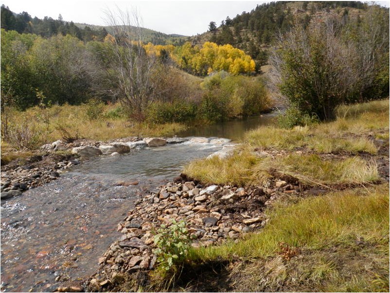
The Yampa River was clearly swollen and discolored Wednesday where it flows through downtown Steamboat Springs, and after Tuesday’s temperatures reached into the 60s, that won’t come as a surprise to valley residents.
It’s impossible to avoid noticing how rapidly snow is melting from roof tops and south-facing embankments. Aspen trees are in the earliest stages of budding in some places, and green shoots from flower bulbs are emerging weeks ahead of schedule.
The Yampa’s flows of 337 cubic feet per second Wednesday, where it passes beneath the Fifth Street Bridge in Steamboat, were more than double the median for the date, according to records kept by the U.S. Geological Survey.
In a winter of sub-par snowfall across Colorado, the west summit of Rabbit Ears Pass has been an isolated location with near-normal snowpack (water stored in the standing snow), according to monitoring by the National Resources Conservation Service.
However, there, at about 9,300 feet, the trend has reverted to unseasonably warm and dry conditions since March began with three days of welcome snowfall.
The NRCS recorded that the snowpack on Rabbit Ears March 4 stood at 94 percent of median for the date. But that number has dropped off steadily since then, losing 12 points – the equivalent of four-10ths of an inch of stored water – down to 82 percent of median for March 18. The median snowpack for March 18 is 22.2 inches and growing…
The Yampa is a tributary of the Green River where it leaves the northwestern corner of Moffat County, ultimately flowing into the Colorado in Canyonlands National Park in Utah.
Just below Craig, where the Yampa has picked up flows from the Elk River, Trout Creek, Elkhead Creek and other tributaries, the river was flowing at 1,040 cfs at midday Wednesday, compared to the median of 638 cfs.
The Elk was also flowing above the median Wednesday — 312 cfs compared to the median for the date of 152 cfs.
The Elk River Snotel, where the RCS monitors snowpack on the western edge of the Mount Zirkel Wilderness in North Routt, is currently at 69 percent of median.
FromThe Grand Junction Daily Sentinel (Dennis Webb):
“Other duties as assigned” may be a typical part of Americans’ job descriptions, but one of Derrick Wyle’s other duties is far from typical.
His official job is serving as a soil conservationist with the U.S. Department of Agriculture’s Natural Resources Conservation Service, assisting agricultural operators in the region out of the agency’s Glenwood Springs office. But on two days a month during the winter, he turns his attention to snow rather than soil, heading out on snowshoes to measure snowpack at a couple of area locations.
“This is collateral duty. Oh shucks, right? Two days out of every month, you have to go out and play in the snow,” Wyle said during a recent demonstration of the work on McClure Pass south of Carbondale. It was part of an educational program put on by the Roaring Fork Conservancy nonprofit group, which advocates and educates on behalf of the Roaring Fork River watershed.
While it beats a day in the office, Wyle’s snow survey duties are clearly far more work than play. As observers learned during Wyle’s presentation, the measurement process itself is fairly exacting. And then there are challenges — like Wyle once having had to dig out a buried gate during a snowmobile ride to one site, and the ever-present prospect of an emergency occurring that could require an unplanned night outdoors.
Wyle and other surveyors must undergo training including building a snow cave in case of such an event, and this soil conservationist who came to Colorado from snow-free Florida has spent the night in one, but as part of the training, not an emergency, thank goodness.
WHY IT MATTERS
The survey work Wyle and others do in Colorado and other states is part of a tradition dating back many generations, and it’s something that looks likely to continue for decades to come, even as automation is increasingly used to measure snowpack levels instead. As it turns out, a number of approaches to getting the job done exist, all with their pluses and minuses, but with the most important thing being that snowpack is accurately measured because of its importance to states like Colorado.
From skiing to rafting and other river-related recreation, to preserving fish and plant habitat and rivers as living ecosystems, “it’s all connected back to snow,” said Sarah Johnson, education and outreach coordinator for the Roaring Fork Conservancy.
Snowpack likewise has implications for agricultural, industrial and municipal water availability and use.
“The mountain snowpack is the West’s largest reservoir, and the only way we know what’s in our reservoirs, that snowpack, are these … measurements that are taken and recorded,” said Chris Treese, external affairs manager with the Colorado River Water Conservation District, based in Glenwood Springs.
Conservation service snowpack data helps in predicting winter avalanche danger and forecasting the year’s spring runoff and streamflows. It assists water managers in managing reservoir and river levels for purposes ranging from fulfilling water rights obligations and providing hydroelectric power to avoiding floods and helping endangered fish.
DOING THE FIELD WORK
Snowpack measurement has a storied history, in Colorado dating at least as far back as Enos Mills in the early 20th century. Besides leading the push for the creation of Rocky Mountain National Park, he once engaged in work as a snow observer, a job that let him spend lots of time in the backcountry he so loved.
That work is carried on in a more systematic manner today by snow surveyors like Wyle, through monthly trips to established snow course sites. Those sites are marked by signs, and surveyors walk a transect along the course, taking measurements at prescribed intervals.
“We try to hit the same point every time we go out there,” Wyle said. Consistency in measurement locations adds to the comparative value of the data being measured over time.
Surveyors work in teams of two, using up to four tubes to sample the snow. The tubes are 30 inches long each, and are screwed together to a length exceeding the snow depth.
“It’s a big (snow) year that we actually get to use all four,” Wyle said.
Surveyors are careful not to touch the metal tubes with bare hands, as that warms them up and can cause snow to stick to the inside. Tossing the tubes into the snow is a good means of cooling them off if they’re too warm.
The business end of the assembled tube has a drill-bit-like end on it. At each measurement point, a surveyor plunges the tube straight into the snow until hitting the ground, then turns the bit slightly in an attempt get a small plug of dirt to ensure the ground has been reached. If there’s no plug when the tube is removed, another sample must be taken.
With the tube still in the snow, the surveyor looks at a scale on it to read the snow depth. It’s then removed, and after digging out the dirt plug the surveyors use a spring scale to weigh the tube with the snow sample inside. The scale reads in inches of water, and after getting an initial reading, surveyors subtract the empty weight of the tube to determine the snow water equivalent.
They then can divide that number by the depth to determine the snow’s density in a percentage form. That density might be a small percentage when falling as powder in cold temperatures, and increase as the snow settles, is packed by wind, or melts and turns back into crystals.
Samples along the snow course should be within about 5 percent of each other in terms of their density, which wouldn’t normally vary greatly in the same area. If there’s a bigger difference, the surveyors know they’re doing something wrong with their measurements and need to check their work.
Slots in the tubes also let surveyors check the core inside. It’s typically not as long as the measured depth, because the snow compacts as the tube is pushed to the ground. But the core should be no less than half the length of measured depth, or surveyors will suspect a problem such as a void in the snowpack, and will measure again.
Once a measurement is completed, a surveyor can tap the tube on a snowshoe to dislodge the core (being careful not to tap with that sharp, drill-bit end), look through the tube to make sure it’s clear (but again, being careful not to do so with the business end against their eyes), pace off to the next transect point and repeat.
“Who knew this could be so …,” Carol DePaul of Carbondale, a participant in the recent tour, said after giving it a try. She didn’t complete her thought, but could have finished it with words like “precise” or “involved.” Wyle gently corrected people as they grabbed tubes barehanded, failed to get a dirt core, forgot to measure depth before removing the tube from the snow, and the list went on. There were enough opportunities to mess up during enough different steps in the process that, for fear of embarrassment this reporter rejected Wyle’s repeated offers to give it a try.
“If I was snow surveying with you I’d make you do it again because you didn’t get any soil,” Wyle teased a braver party who had just pulled the tube from the snow.
HIGHER-TECH MEANS
Still, the process isn’t rocket science, and it probably becomes second nature after enough repetition, which there’s plenty of on this job.
But not far from where Wyle was giving his demonstration on McClure Pass sits on automated snowpack measurement site that incorporates, if not rocket science, at least a little bit of space technology in its operation. It’s known as a SNOTEL, or snow telemetry, site, something that has become the mainstay of the conservation service’s snow survey program.
Key to such solar-powered sites is a pillow-like device that sits on the ground and contains antifreeze. As snow falls on it, the weight pushes some of the antifreeze out of the pillow and it rises up a measurement tube in a cylindrical room nearby. The measurement can then be transmitted by a signal that’s sent high into the sky, bounces off orbiting meteor debris and returns to Earth at a centralized data collection center.
A tower over the pillow also has a small sensor arm reaching out horizontally that can measure the depth of the snow above the pillow by ultrasonic means, based on how long it takes a signal to reach the snow and return to the sensor.
Other gauges at SNOTEL sites also take rain and temperature readings. All the readings are accessed hourly.
Yet other means have been employed to measure snow. At some locations, airplanes fly over sites containing posts of different heights. Snow depth can be determined by how many posts are visible. Density and snow water equivalent can be inferred based on readings in similar but physically accessible nearby areas.
One such site used to exist at McClure Pass, as did a manual snow course, but now the conservation service has only a SNOTEL site there.
Wyle said he thinks aerial sites tend to be found these days in places like California and the Pacific Northwest, where snow measurements may be wanted in remote, deep locations. Such coastal locations also may have 20 feet of snow, and a less-precise measurement may be less important.
A far more modern, aerial-based approach to snowpack measurement makes use of LIDAR, or Light Detection and Ranging, which is like radar, but uses a laser rather than sound. Terrain can be measured by flying overhead, then again in winter to measure the difference with snow on the ground, using highly accurate mapping.
“This is the future of snow science, snow surveys,” said Johnson, of the Roaring Fork Conservancy, noting how far things have come from the days of Enos Mills.
But that future still may be a ways off. Brian Domonkos, the conservation service’s Colorado snow survey and water forecasting supervisor, said LIDAR isn’t used at all by the service in Colorado. Wyle said it can be hazardous and expensive to have to fly all over.
“I don’t think this is going to catch on until we can do satellite-based LIDAR,” Wyle predicted.
From the Fort Collins Coloradoan (Sarah Jane Kyle):
Northern Colorado’s river basin is nearly at normal snowpack levels for the year, but still below last year’s snowpack.
The South Platte River Basin is at 96 percent of the median but only at 67 percent of 2014, which was 143 percent above normal, according to data from NRCS SNOTEL sites, which measure snowpack instantaneously.
The Cache la Poudre Basin, which is part of the South Platte River Basin and controls much of Fort Collins’ water supply, was at 103 percent above normal snowpack during a formal March 1 measurement. The same time last year, the basin was at 147 percent of normal.
During the same measurement, the South Platte was at 110 percent of normal. The same time last year, it was at 151 percent of normal.
Heavy snows in February pushed both basins — and Fort Collins proper — above average. Last month was the snowiest February in Fort Collins since the 1920s with 17 inches of snowfall, or 10.1 inches above normal, at the CSU weather station in February.
Today's snowpack water equivalent in the Colorado basin is 87% vs 2014: 128%, 2013: 77%, 2012: 68%. pic.twitter.com/2wlUXJBm79
The last 50-foot pipe of the 50-mile-long Southern Delivery System arrived at a construction site Wednesday, marking a key milestone for the project as it nears completion next year both on time and under budget.
“We put to rest a lot of doubters that we’d get this done,” said Lionel Rivera, Colorado Springs’ former mayor, who helped approve the project.
With Kool & The Gang’s “Celebration” playing in the background, a truck hauled the massive blue pipe to a site just south of Pikes Peak International Raceway. Crews will place it underground in the coming weeks, completing a system spanning from Pueblo Reservoir to a new water treatment facility in Colorado Springs, which is under construction.
More than 7,000 of the steel, 66-inch-diameter pipes were installed since in 2010. That included a mile-long stretch bored 85 feet below Interstate 25 – a tunnel that was $10 million cheaper than creating a surface trench, according to Colorado Springs Utilities.
Current and former elected officials from across southern Colorado, along with several contractors who have worked on the project, were among scores of people on hand to watch the pipe being delivered. Many signed their names on it.
“It’s great – we’ve been at this a long time,” said John Fredell, the Southern Delivery System’s program director. “It’s a wonderful, wonderful day to celebrate.”
Three pump stations and the treatment facility are expected to be completed this year, with the system up and running for customers in Colorado Springs by the first quarter of 2016, Fredell said.
The project is on track to cost $841 million, below Colorado Springs City Council’s approved budget of $880 million in 2009, which did not account for inflation or rising material costs. The council also serves as Utilities’ board. Those savings rise to about $150 million when factoring in the cost of inflation and increases in material costs, said Fredell, who credited design changes to the pipeline and water treatment facility for much of the savings.
One of the biggest water projects in the western U.S. will hit a major milestone this month, when the last piece of 50 miles of pipe is laid for the Southern Delivery System, the $841 million project to bring new water supplies to Colorado Springs and nearby communities.
The project includes 50 miles of pipeline, three pump stations and a water treatment plant. It will deliver water from the Pueblo Reservoir to Colorado Springs, Fountain, Security and Pueblo West.
More than 7,000 sections of blue-colored, welded, steel pipe 50 feet long and most of it 66 inches in diameter were installed on the project during the last 3 1/2 years of construction.
The project spent $204 million on pipe and installation, according to the Colorado Springs Utilities.
“The pipe is the main artery for this water project and we are extremely pleased with how the pipeline construction went,” said John Fredell, the program director for the Southern Delivery System project.
The project is in the final year of construction and Fredell said the costs are expected to be nearly $150 million under the original budget…
Northwest Pipe (Nasdaq: NWPX), based in Vancouver, Washington, manufactured the SDS pipe at its Denver plant.
Three contractors installed the pipe, Garney Construction, headquartered in Kansas City with an office in Littleton; ASI/HCP Contractors of Pueblo West; and the heavy civil division of Layne, a construction firm based in The Woodlands, Texas, which has four offices in Colorado.
Construction is continuing on other elements of the Southern Delivery System project, including a $125-million water treatment plant and pump station that will have the capacity to treat and pump 50 million gallons of water per day. Three pump stations will help move water uphill, about 1,500 feet in elevation, from the Pueblo Reservoir, also are under construction.
Construction on the remaining portions of the project are expected to be finished by the end of 2015.
Community leaders gathered Wednesday to celebrate the completion of pipeline construction for the Southern Delivery System (SDS). The project consists of more than 7,000 50-foot sections of steel pipe that have been installed over the last three and a half years. The pipe will transport water stored in the Pueblo Reservoir north to Pueblo West, Fountain, Security and Colorado Springs.
“It’s taken many years and it’s taken many city councils and it’s taken many leaders and many workers to accomplish this,” said Colorado Springs City Councilman Merv Bennett. “Our friends to the south, the Lord gave them the Arkansas River as their delivery system. To the north, Denver has the South Platte River as their delivery system. We have Fountain Creek and we ran out of that water in 1912.”
Proponents of the SDS argue the pipeline will ensure Colorado Springs and surrounding areas can continue to grow, especially toward eastern El Paso County. The region will have to worry less about drought and watering restrictions.
“Water is important. It’s the lifeline of a community,” said Lionel Rivera, former mayor of Colorado Springs. “It’s the way you grow and I think we’ve ensured the water supply for at least the next 50 years.”
Rivera was mayor from 2003 until 2011 and helped get the project rolling. He said Tuesday that it was one of the most rewarding things he did as mayor.
“It’s very exciting, a little bit emotional to see that pipe,” Rivera said. “It just made me think of all the stuff we had to go through to get this approved. We were told back when we started it that it couldn’t get done from a political standpoint, but we proved the doubters wrong.”
The project has had opponents over the years, many from Pueblo who are concerned over stormwater issues.
Though pipeline construction is complete, workers still need to build water treatment plants and pump stations. The first drop of water is expected to be delivered in spring 2016.
Construction crews are poised to lay the final pipeline link for Colorado’s biggest water project in decades — an $841 million uphill diversion from the Arkansas River to enable population growth in Colorado Springs and other semi-arid Front Range cities.
Eleven 2,000-plus horsepower pumps driven by coal-fired power plants will propel the water from a reservoir near Pueblo through a 50-mile pipeline with an elevation gain of 1,500 feet.
This is the first phase, moving up to 50 million gallons a day, for a Southern Delivery System that utility officials estimated will eventually cost $1.5 billion.
“It means we will have greater water security,” Colorado Springs utilities spokeswoman Janet Rummel said. “Businesses need water. Our communities need water to survive. It means we can continue to serve our population as it grows.”
Water challenges loom across Colorado, with state officials projecting a 163 billion-gallon shortfall. A few years ago, drought forced Colorado Springs to stop watering municipal parkways and gardens.
The diverted water can be used only within the Arkansas River Basin, officials said, ruling out sales to south Denver suburbs. And the river water, after treatment, must be returned to downstream farmers.
Colorado Springs residents have been paying for the project through water bills, which increased by 52 percent over four years. Utility officials spent $475 million from bonds.
The water will flow by next March, officials said. At full buildout, the system will store water in two new reservoirs east of Colorado Springs.
The new north outlet works at Pueblo Dam — Photo/MWH Global
The Southern Delivery System pipeline’s completion was marked by a contingent of El Paso County officials and a smattering of Pueblo County folks as well.
For John Bowen, president of ASI Constructors of Pueblo West, the SDS project has meant bread on the table as well as water in the pipes.
“It’s generated $50 million in contract values for our company,” Bowen said during a ceremony to mark completion of the SDS pipeline from Pueblo Dam to Colorado Springs. “We were able to grow as a business during a time when a lot of contractors were laying people off.”
ASI was the primary contractor for the connection at Pueblo Dam, as well as 12 miles of the 50-mile SDS pipeline route, and relied on 70 local businesses for support services. The SDS project generated $800,000 in wages for ASI workers.
More Southern Delivery System coverage here and here.
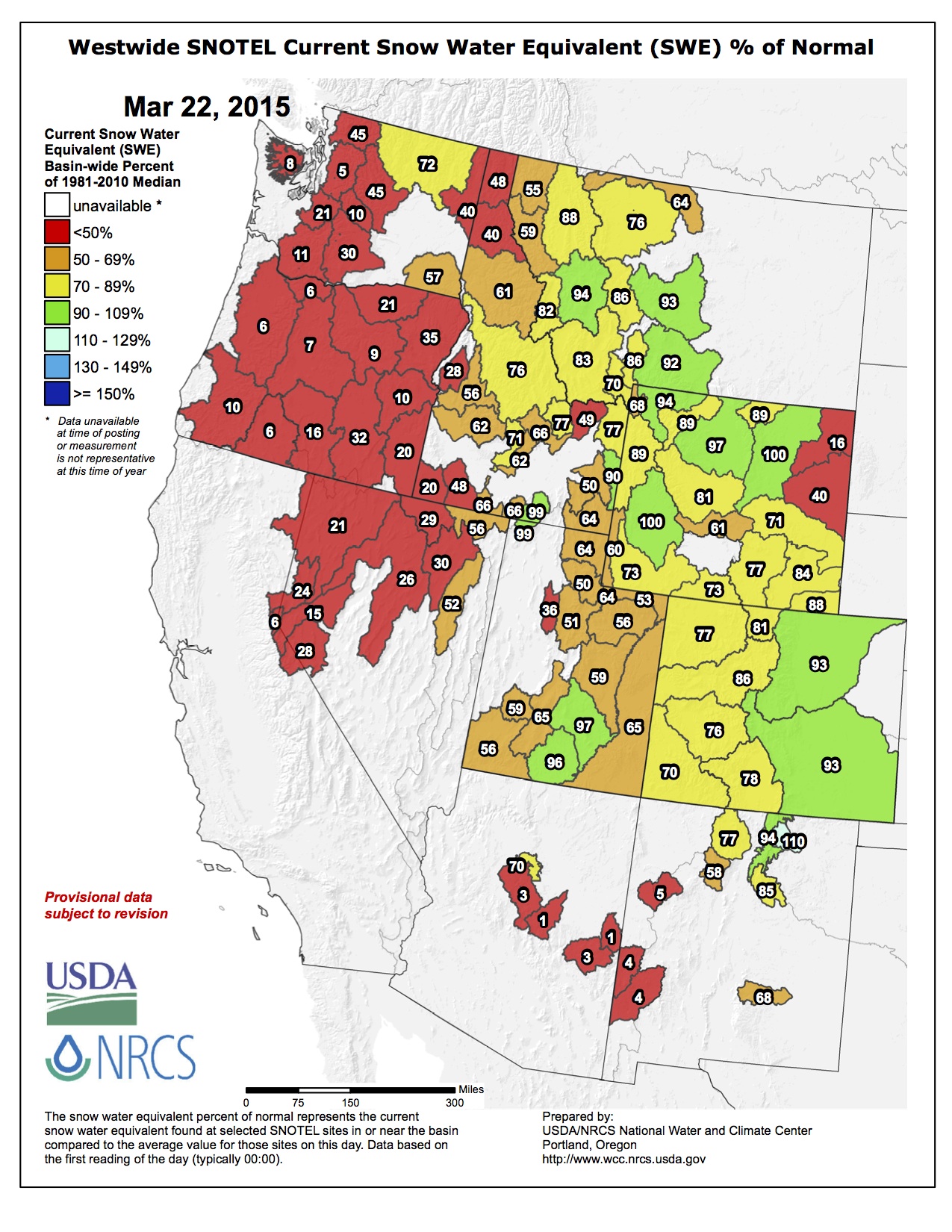
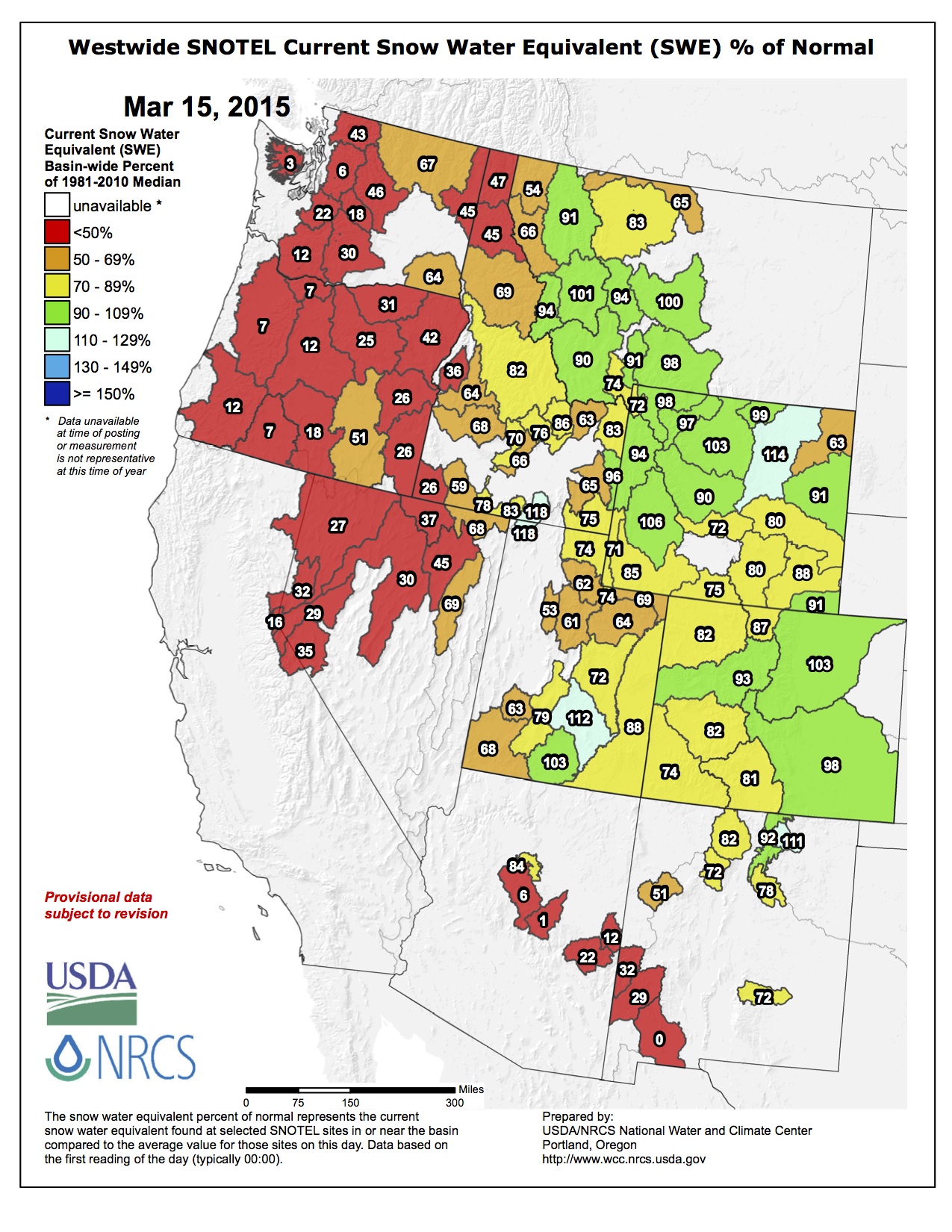
Westwide SNOTEL snow water equivalent as a percent of normal March 17, 2015
From the Associated Press (Dan Elliott) via The Denver Post:
Snowpack in the mountains and valleys where the Colorado River originates has been shrinking since the beginning of March, a federal water expert said Tuesday.
The snow ranged between 89 and 91 percent of the long-term average, depending on which measurement is used.
“We dried out relatively significantly here since the beginning of March,” said Brian Domonkos, supervisor of the Colorado Snow Survey for the U.S. Agriculture Department…
Domonkos told the state task force on water availability that recent warm weather had begun to melt the snow at lower elevations in parts of the Colorado River basin.
Colorado’s snowpack is closely watched because it provides water for four major river systems that originate in the state: the Platte, the Arkansas and the Rio Grande as well as the Colorado.
The Colorado River is under especially close scrutiny because it helps supply California, which is in the midst of a historic drought. The most recent assessment available showed 40 percent of California was in an exceptional drought, the driest of five categories used by the federal government’s U.S. Drought Monitor. Nearly 28 percent was in an extreme drought, the second-driest category.
In addition to the Colorado River basin, three other river basins in the western part of the state feed into the Colorado River downstream. In those basins, the snowpack was 72 to 79 percent of average Tuesday.
East of the Continental Divide, snowpack in the basin that feeds the South Platte was average, while the North Platte River basin was at 85 percent. The North Platte flows north into Wyoming before turning east into Nebraska, where it joins the South Platte to form the Platte River.
The Arkansas River basin had 96 percent of average snowpack, and the Upper Rio Grande basin had 77 percent.
Early indications are that the risk of flooding in Colorado will be lower this year than last but still higher than average, said Klaus Wolter, a climate scientist with the Cooperative Institute for Research in Environmental Sciences in Boulder.
Wolter said little dust appears to have accumulated on Colorado’s snow this year. Because of its darker color, dust can absorb more heat than snow and hasten melting and the spring runoff.
Rain or extended warm spells in springtime can speed up the runoff and trigger floods by putting more snowmelt into Colorado’s rivers and streams than they can handle.
U.S. Sens. Michael Bennet, D-Colo., and Cory Gardner, R-Colo., and Rep. Scott Tipton, R-Cortez, penned a letter to Bureau of Reclamation Commissioner Estevan López requesting open access to the Lake Nighthorse Reservoir at the earliest possible date.
The La Plata County reservoir was completed in 2011, but a recreation plan has not yet been agreed on, and the area has remained closed to the public.
Lake Nighthorse is currently being managed by a coalition of partners that helped build the original reservoir.
The Animas La Plata Water Conservancy District commissioned a report that found recreation at Lake Nighthorse could stimulate upwards of $12 million in annual economic benefits for La Plata County.
“Given this momentum, we encourage the Bureau to expedite and prioritize its environmental analysis of the proposal, which would clear the way to open the lake to public access,” the letter reads.”
The letter also says that as of March 6, all members and partners of the Animas-La Plata Project’s Operation, Maintenance and Replacement Association have endorsed the assessment of a draft recreational plan for the lake.
Several other entities have also expressed support for recreation at the reservoir, including the Southern Ute Tribe, the Ute Mountain Ute Tribe, the Colorado Water Resources and Power Development Authority, and the city of Durango.
“Given this impressive show of support throughout the region, we urge the Bureau to redouble their efforts to analyze and adopt an agreeable plan that will open Lake Nighthorse to recreational access as soon as possible,” the letter reads. “We look forward to your response including a timeline for next steps and to the resolution of this issue.”
Durango Mayor Sweetie Marbury said she is looking forward to the city’s residents being able to enjoy the area for swimming, fishing boating and other recreational uses.
“I am pleased to see that all the partners are now on board to initiate a process that we hope will open Lake Nighthorse as soon as possible,” Marbury said. “I appreciate our congressional delegation showing leadership on behalf of Southwest Colorado to support our efforts to open Lake Nighthorse to the public.”
More Animas-La Plata project coverage here and here.
Democrats on the House State, Veterans and Military Affairs Committee on Monday killed Senate Bills 64 and 93, both sponsored by Sen. Jerry Sonnenberg, R-Sterling, on party-line votes.
SB 93 would have required local governments to compensate mineral-rights owners for imposing new regulations that limited the use of their land, while SB 64 would have banned the federal government from requiring ski resorts to hand over their water rights in exchange for permits to use federal land.
Democratic leaders had complained that SB 64 was unenforceable and was moot after the federal government stopped requiring such concessions several years ago, and they claimed that SB 93 established a takings principle that only courts are allowed to interpret.
But Rep. Jon Becker, the Fort Morgan Republican who acted as the House sponsor for both bills, said afterward that Democrats “have set a dangerous precedent for all property owners in Colorado by granting their misguided ideology more weight than private property rights.”
Senate Bill 93 would have offered a means for mineral-rights owners to claim compensation from a local government if that government reduced the value of the owner’s royalties by at least 60 percent.
The measure previously made its way through the Republican-controlled Senate but was rejected on a party-line vote by the Democratic-controlled House State, Veterans and Military Affairs Committee.
A second measure, House Bill 1119, would have also held a local government liable for the value of lost royalties if that government enacted laws that limited natural-gas and oil extraction. That measure was also killed by the House earlier in the session.
Supporters said the issue had to do with property rights. Colorado is still grappling with the controversial issue of fracking after a task force recommended only modest steps to address local control over rules and regulations.
“We can all agree that in the state of Colorado these mineral rights are as much of a property right as the property you have in your home,” said Rep. Jon Becker, R-Fort Morgan, who sponsored SB 93. “If we do not allow access, then they should be just compensated for the loss of use of those rights as if they were a taking.”
The state currently holds the authority to enact rules and regulations. But several local governments have taken matters into their own hands through ordinances and voter initiatives. Those actions have setup legal battles.
Residents are threatening to once again take the issue to the ballot in 2016 since the oil and gas task force did not take concrete steps.
Mineral-rights owners worry that a ban on fracking in local communities would result in an elimination of their property.
But environmentalists and homeowners spoke of the health, safety, environmental and nuisance factors associated with fracking, including loud noise and the fear of contaminating groundwater with chemicals that are injected into the ground along with sand and water to break open natural-gas and oil deposits underground.
“The point of government is to balance the rights of some people with the rights of other people,” said Jen Bolton, representing both the Audubon Society and Colorado Trout Unlimited. “If you take away the ability of a community to regulate, you take away the ability to solve those sort of issues.”
A warm week of weather left the state with a decreased snowpack of just 84 percent of median in terms of moisture content. A cold front is expected to move into the state today, bringing with it some additional moisture later in the week. March and April are traditionally the snowiest months, providing much of the water supply for later in the year.
But for now, the snowpack is below average throughout the state, with the exception of higher elevations in the central mountains. The South Platte and Arkansas River basins are near normal, overall, while the Upper Colorado River basin is at just 91 percent.
The flow in the Arkansas River below Pueblo Dam doubled Sunday to about 330 cubic feet per second after the end of the winter water storage program. Area ditches began taking water, rather than keeping it in storage at Lake Pueblo and other reservoirs in the Lower Arkansas Valley.
Water use by Puebloans began to increase over the weekend as well, but not dramatically, said Seth Clayton, director of administrative services for the Pueblo Board of Water Works. Water use increased by about 500,000 gallons Sunday, as temperatures hit 79 degrees.
“I think people are still nervous and haven’t kicked up their sprinkler systems yet,” Clayton said. “It really starts to go up at the end of March.”
Still, Pueblo water use has averaged just over 12 million gallons per day through Sunday, up a bit from the five-year average. By the end of March, it should be around 18-19 million gallons per day.
Following record snow in February, Pueblo is still above average with 1.43 inches of precipitation since Jan. 1.
Two weeks of wet weather through the end of February and beginning of March have provided a significant increase in snowpack statewide and an even greater boost to those southern Colorado basins that are still ailing after several consecutive years of below-normal snowpack.
Despite substantial accumulations statewide, snowpack has not quite returned to normal; it was 87 percent as of March 1.
Further investigation of SNOTEL data indicates that during the nine-day period of Feb. 20 through March 1, the state of Colorado received two inches of snow water equivalent, 181 percent of the normal for that time frame. That is a 9 percent increase in snowpack percent of median. Preliminary numbers into March indicate an additional 7 percent increase between March 1 and March 5. On March 1, with 20 percent of the mountain snowpack accumulation season remaining, time is dwindling to close the gap and reach typical statewide peak snowpack levels.
Brian Domonkos, snow survey supervisor with the U.S. Department of Agriculture Colorado Natural Resources Conservation Service, said, “While not every major watershed in the state saw snowpack improvements this month, precipitation during the latter half of February was a highly beneficial to many water budgets across the state.”
The recent storm patterns were most beneficial to the Rio Grande watershed, receiving 300 percent of normal snowfall in the last nine days of February. The South Platte and the Rio Grande both received a 13 percent gain over the course of February. In the South Platte River basin, snowpack has not reached 2011 or 2014 levels at this point, but conditions are still better than 1988, 1993, 1994 and above normal.
Statewide precipitation for the month of February was right at normal, a drastic change from 45 percent of average received during the month of January. Year-to-date statewide mountain precipitation totals increased 3 percent since last month. Colorado reservoir storage increased as well from Feb. 1 to March 1 from 104 to 105 percent of average. Stream flow forecasts saw marked improvements most particularly for the state’s southern streams.
Domonkos put the recent weather into perspective. “This storm could not have come at a better time,” he said. “Without this storm, if the same weather patterns since Jan. 1 had persisted through spring, mountain snowpack would have narrowly reached only the minimum snowpack peak.”
From the Associated Press (Dan Elliott) via The Denver Post:
Colorado water officials will get an update on mountain snowpack and an early look at potential flooding threats from the spring runoff on Tuesday.
State task forces on water availability and on floods are holding a joint meeting to hear reports on weather forecasts, snow levels and the possibility of flooding when spring arrives in the high country and the snow begins to melt.
Colorado’s snowpack is closely watched because it provides water for four major river systems that originate in the state: The Colorado, the Platte, the Arkansas and the Rio Grande.
The Colorado River is under especially close scrutiny because it helps supply California, which is in the midst of a historic drought. The most recent assessment available showed 40 percent of California was in an exceptional drought, the driest of five categories used by the federal government’s U.S. Drought Monitor. Nearly 28 percent was in an extreme drought, the second-driest category.
In Colorado, the snowpack in the mountains and valleys that directly feed the Colorado River was 91 percent of the long-term average Monday. In three other Colorado basins that eventually feed into the Colorado River, the snowpack was 73 to 81 percent of average.
East of the Continental Divide, snowpack in the basin that feeds the South Platte was 104 percent of average, while the North Platte River basin was at 86 percent. The North Platte flows north into Wyoming before turning east into Nebraska, where it joins the South Platte to form the Platte River.
The Arkansas River basin had 96 percent of average snowpack, and the Upper Rio Grande basin had 80 percent.
Rain or extended warm spells in springtime can hasten the spring runoff and trigger floods by putting more snowmelt into Colorado’s rivers and streams than they can handle.
Think it’s been unseasonably warm? So do the walkers and runners out on the recreation paths, the fly fishermen in the Eagle River and the skiers cruising down the mountain in short-sleeves.
March weather data shows that this winter has brought stretches of higher-than-average temperatures and that mid-March has had the thermometer at or near all-time record highs for the month. The highest recorded temperatures for Vail in March are in the mid-50s, which are similar to what Eagle County has been seeing the past few days. Typically, average March temperatures are closer to the mid-40s, according to National Weather Service data.
According to SNOTEL information gathered on Vail Mountain, the record mid-March high for the last 30 years was 56 degrees in 1995, with several other very warm Marches in 2011 and 1999. March 15 of this year was very close to those record highs, with a max temperature of 53 degrees. However, Monday could break that record, with the forecast calling for a high of 56.
“Essentially we’re under a ridge of high pressure, meaning there’s a bubble of warm air in the atmosphere over us,” said National Weather Service meteorologist Ben Moyer. “In fact, most of Colorado is seeing high temperatures. On Monday, Denver is at 69, and Pueblo is in the lower 80s.”
However, as National Weather Service data acquisition program manager John Kyle points out, this winter has not only brought warm highs, but also a good number of very cold days.
Dec. 14 was a record warm day, as were a few days in February, Kyle said. However, there was also a record low day recorded around New Year, and the first week of March was colder than the historical average.
“Minus the latter part of December and a couple brief days, it looks like it was a warmer than normal winter, and that was the case for most of the Western Slope,” said Kyle.
SNOWPACK STILL OK
The good news is that snowpack levels are still looking strong, ranging from 83 percent of the average snow water equivalent to 113 percent of average at the Eagle River headwaters at Fremont Pass to 107 percent on Copper Mountain.
“The (snow water equivalent) took a huge hit on Vail Mountain between Sunday and Monday, but Fremont and Copper held tight. Does that cause concern? Yes, but there’s still a good month of winter left,” said Diane Johnson, of the Eagle River Water & Sanitation District.
Snowpack affects reservoir levels, fire danger for later months and river levels. Mountain residents should certainly be concerned about stream flow levels, but Johnson said it’s too early to tell if the local waterways will be normal or suffering come spring.
“A few years ago, we were saved by end-of-winter storms after a very poor snow season,” she said. “Even if we get snow in late April and May like we did in 2013, it can really help our situation here.”
As far as precipitation, the predictions are positive. The outlook from the Colorado Climate Center calls for higher than average chance of precipitation during the next few weeks, although it is also calling for higher than average temperatures.
Flood irrigation in the Arkansas Valley via Greg Hobbs
From the Sterling Journal-Advocate (Marianne Goodland):
The weather did not deter those interested in “Water: Colorado’s Treasure,” this year’s theme. The Denver-area forum is in its second year of sponsorship from the Colorado Agricultural Leadership Program.
The event also marked the first time new Ag Commissioner Don Brown of Yuma spoke before the well-attended forum. Brown is less than two weeks into his new job, but spoke about his history with water issues. While acknowledging he needs to learn more about surface water, Brown said his family was early irrigators on the Ogallala aquifer. Brown also made a pitch for the interest in agriculture held by Gov. John Hickenlooper. “He’s extremely passionate about agriculture, wants us to succeed in agriculture. And I intend to achieve those goals for him,” Brown said.
Craig Beyrouty, dean of the college of agricultural sciences at Colorado State University, discussed CSU’s academic work on water issues. He said 25 percent of the faculty in the ag college work on water policy, water conservation, recycling, water quality and agricultural perspectives on water. “We’ve just finished a drought of three to four years,” Beyrouty said, although some sectors of the state have yet to recover, most notably, southeastern Colorado. “What will we do if we have a drought of 10 to 15 years? Are we prepared for it? We are not, and that’s where innovation and science-based information” will play a big role on short-term and long-term drought.
The ag forum also heard from the Environmental Protection Agency, not always one of the most welcome of federal agencies. Speaking on behalf of the EPA, however, was Ron Carleton, who until recently was Colorado deputy commissioner of agriculture and for six years chief of staff in Washington for then-Rep. John Salazar, newly retired as Commissioner of Agriculture.
Carleton, a resident of Fort Collins, is now counselor to the EPA administrator for agriculture policy, and works as a liaison between the agency and farmers and ranchers.
Carleton got friendly applause from the audience. “It’s heartening to be identified with the EPA and you still applauded,” he joked.
Carleton said his role is to make sure agriculture has a seat at the table when views of the industry are discussed and to promote meaningful engagement between agriculture and the EPA.
Among the big issues: Waters of the US Rule, also known as the Clean Water rule, which has generated considerable controversy within agriculture. Carleton said the rule is likely to be finalized later this spring, but that it is expected to be changed significantly based largely on the feedback from the ag industry. He noted the EPA got more than a million comments to the agency, with about 800,000 coming from form letters and postcards and another 200,000 unique comments.
According to Carleton, the administrator said that after the comments and more than 400 outreach meetings around the country, that the agency probably did not get some things right in the original proposal. He did not elaborate on the possible changes.
The Clean Water rule, under the federal Clean Water Act, defines the scope of waters protected by the Clean Water Act. The EPA and the U.S. Department of Agriculture both maintain that the rule would not add any regulation of water to agriculture, but the ag industry has disagreed. Among the concerns are the rule’s broad definitions, which some claim could place even dryland contained in floodplains under the EPA’s jurisdiction.
“The administrator is genuinely concerned that we get this right,” Carleton told this reporter later in the morning. With the comments received and the modifications planned, it will provide more certainty about what’s jurisdictional and what isn’t.
Carleton said his challenge is how to better engage the agricultural community and ensure there’s a good meaningful two-way dialogue with the agency. There have been efforts to do that in the past, but EPA Administrator Gina McCarthy is interested in better engagement, Carleton said. As a matter of public policy, the EPA wants to protect water and air, human health and the environment, but the trick is how to balance those requirements with concerns about impacts on agriculture.
Among the other challenges faced by the agency, Carleton told the audience that they’re looking at worker protection standards on pesticide handling, pollinator health, and further work on nutrient management. Carleton noted that the Des Moines, Iowa regional water utility recently announced its intention to sue upriver countries because of their inability to control nutrient runoff.
“No question we want clean water… clean air… and a clean environment. Also no question we want a prosperous and productive agricultural sector as well, one that produces the fuel, food and fiber” for the United States and around the world. “We can find ways to work together to achieves those goals,” Carleton said.
The forum also witnessed the first awarding of the governor’s agriculture export awards. The “New Exporter Award” went to Watkins Grain. The company was contacted in 2010 by buyers in the Philippines, seeking white millet. The company learned the rules and procedures for exporting, and now is shipping containers of millet on an almost daily basis, providing a new market for Colorado growers.
The “Experienced Exporter of the Year” was Keeton Industries of Wellington, which exports aquatics technology to 19 international markets, and has been doing so since the 1970s.
The afternoon breakout sessions looked at maximizing the value of water by enhancing environmental benefits of irrigation, a legislative update, the value of ag water, water quality issues in four Colorado rivers and a look at the documentary “Droughtland.” The 2014 film, produced by Steffan Tubbs of KOA radio, looks at drought conditions in southeastern Colorado.
From the Sterling Journal-Advocate (Marianne Goodland):
Among the bills awaiting action (and funding) in the House are House Bill 15-1013 and HB 1178. The latter would take $500,000 over two years from general funds and put it into an “emergency dewatering grant account.” If the bill makes it to the governor’s desk and is signed, then the money, under the control of the Colorado Water Conservation Board (CWCB), could be used to start emergency pumping of wells permitted for dewatering in the Gilcrest and LaSalle areas. Those areas are experiencing high groundwater that has damaged crops, flooded basements and streets.
Rep. Lori Saine, R-Firestone, one of the bill’s sponsors, told this reporter she sought the legislation as a short-term fix to the groundwater problems for residents in her district. It is “the only short-term solution available for Gilcrest and surrounding areas,” she said this week.
Saine pointed out that her bill has the support of the South Platte Basin Roundtable.
But her bill is at odds with another that is intended to address the high groundwater problem in her district and in Sterling.
HB 1013 comes from the annual interim Water Resource Review Committee, of which Sen. Jerry Sonnenberg, R-Sterling, is a member. Sonnenberg is the Senate sponsor of HB 1013, along with Sen. Mary Hodge, D-Brighton. In the House, HB 1013 is sponsored by Rep. Don Coram, R-Montrose. It passed the House Agriculture, Livestock and Natural Resources Committee in late January.
Both bills arise from the 2013 CWCB report that recommended local solutions for high groundwater problems in Gilcrest/LaSalle and north from Sterling to Julesburg, rather than a one-size-fits-all plan.
HB 1013, also awaiting action from the House Appropriations Committee, would require the CWCB to conduct a study that would test alternative methods for lowering the water table along the South Platte near the Gilcrest/LaSalle and Sterling areas. The bill sets up application and approval criteria for the pilot projects, which would last four years. The bill also deals with related issues, such as augmentation plans and recharge structures (ponds or ditches).
HB 1013 sets up a lengthy process for the pilot projects, starting with a 45 days’ notice for proposed criteria and public comment. Another 75 days is allotted for comments on the pilot project applications. Once the CWCB approves the applications, another 35 days is available for appeals.
Should it become law, the bill wouldn’t go into effect until around Aug. 5. That contrasts with the timelines for HB 1178, which addresses the problem only in Gilcrest. Because HB 1178 has what’s known as a safety clause, if signed, it would go into effect immediately.
“Had 1013 addressed the immediate problem of flooding basements and potential health and safety issues, I would not have run 1178,” Saine said this week. Testimony given during the HB 1178’s March 2 hearing indicated that pumping could start as soon as April 15.
But the emergency dewatering plan wasn’t supported by the water resources review committee. During their Sept. 30, 2014, meeting, then-Sen. Greg Brophy, R-Wray, commented that if action was not taken soon, those affected by the high groundwater problems would take legal action. “We owe it to the people of Colorado” to solve this problem with a smart approach, Brophy said. Dewatering wells take out the water “and dump it in the river, which I think is a waste of water. How can that be okay if it’s not okay to pull it out for beneficial use?”
Coram, during the January hearing on HB 1013, said dewatering was not the solution. HB 1013 is not the only solution, he said, “but it’s a start.”
HB 1013 has another important distinction: its cost. While HB 1178 seeks $500,000 in general funds, which come from income and sales tax, HB 1013 seeks less than $100,000 over two years for evaluation of the pilot projects. Sonnenberg told this reporter this week he is attempting to get those dollars from the CWCB construction fund rather than tapping into the general fund.
HB 1013 does not address the costs for implementing the plan that would come from the pilot projects.
A bill that would allow residential rainwater collection sailed through a committee hearing Monday, making headway in Colorado’s decades-old water rights battle.
House Bill 1259 passed the Agriculture, Livestock & Natural Resources Committee 8-5 and now advances to the full House.
“We’re simply wanting to allow people to collect the rain that falls off of their rooftops … to put back into the earth,” said the bill’s sponsor, Rep. Daneya Esgar, D-Pueblo.
The proposal would limit total barrel size to 100 gallons per residence. Proponents say that the average homeowner could collect about 600 gallons of water annually to water their lawns or gardens.
That amount of water could sustain a vegetable garden or a flower bed, according to Drew Beckwith, water policy manager for Western Resource Advocates, who testified for the legislation.
“One of the most important things this bill accomplishes is putting urban and suburban water users in the mind frame of conservation,” said co-sponsor Rep. Jessie Danielson, D-Wheat Ridge.
Esgar said people already use rain barrels and were shocked to find out it’s illegal. Beckwith said Colorado is the only state to prohibit residential collection of rain.
Colorado’s water rights system — known as “first in time, first in right” — emerged during the mining booms of the 19th century. Using that rhetoric, people argue that collecting rainwater prevents it from reaching rivers, violating the rights of downstream users.
“It’s a violation of the doctrine of prior appropriations,” said Pat Ratliff of the South Metro Water Authority. “It’s not their water (to use). It’s a return flow that somebody downstream has a senior right to.”
Lawmakers are working to change a decades-old law that prohibits Coloradans from collecting rainwater.
It’s currently against the law — in almost all cases — to put a bucket by a downspout and catch the rain because that water is the property of people downstream. But a bill changes water rights, allowing homeowners to store up to 100 gallons of rain at a time.
It’s been illegal to collect rain in Colorado for more than a century. It can be directed by changing gutters or grading, but it can’t be collected.
“Many people I’ve spoken to think I’m joking when I tell them that the collecting of the rain off of your roof is illegal,” said Rep. Daneya Esgar, D-Pueblo.
Esgar and Rep. Jessie Danielson, D-Wheat Ridge, say it’s time the law changed. A recent study found 97 percent of rain doesn’t even make it to a stream because it’s absorbed by vegetation or evaporates.
Esgar and Danielson say homeowners ought to be able to collect and use the water where they need it most, as long as they put it back into the ground.
“Water collected through this bill will not even be enough to water the average blue grass lawn in Colorado even once,” Esgar said.
“Anytime that you manipulate that system — any — it affects somebody,” rancher Jim Yahn said.
Yahn says the study looked at only a small natural area in Douglas County, not municipal runoff. He says even a little water makes a big difference.
“There are people waiting in line for that water, and if they don’t get that little influx from a rainfall event, then they don’t get that water that they are going to put on their crops, that they’re going to use to offset their well pumping,” Yahn said.
Supporters insist the bill will result in more water for everyone by encouraging conservation.
“Perhaps when they see how little water 100 gallons really is, they’ll think twice about how much water they’re using when they turn that faucet on and it comes pouring out to water their lawns,” Danielson said.
Under the bill Coloradans can only use the rain collected outside — on flowers for example.
The state is in the middle of a 10-year study of rain harvesting in both urban and rural areas. Opponents say lawmakers should wait until that’s done.
The bill passed committee Monday and is headed to the full House.
From the Loveland Reporter-Herald (Kenneth Jessen):
In 1975, a Colorado dam inspector hiked the half-dozen miles to the Lawn Lake dam and reported that it was in need of a thorough inspection after the snow melted. Another inspector reported two years later that the dam was in fair condition and suggested that its owners make repairs.
On Aug. 8, 1978, a third inspector reaffirmed the marginal rating for the dam and recommended that it be observed when the reservoir was full.
The caulking between the outlet pipe and the release valve started to allow water to trickle along the outer surface of the pipe. Once a small channel had eaten into the earthen dam under pressure, it rapidly expanded.
On July 15, 1982, the Lawn Lake dam failed catastrophically. The release of water was heard by campers along the Roaring River. One man below the dam was swept to his death in the churning water.
The wall of water forced large boulders down 2,500 vertical feet to Horseshoe Park acting as battering rams. The forested banks of Roaring River where scoured away in a landslide of thousands of tons of material.
Much of the impact of the flood was absorbed by the broad expanse of Horseshoe Park. An alluvial fan quickly formed at the mouth of Roaring River. The debris was pushed across Horseshoe Park damming the Fall River and forming a shallow lake.
Fortunately, Steve Gillette was collecting trash at the Lawn Lake trailhead. It was 6:23 a.m. when he sighted the flood coming toward him and alerted park officials.
In an interview with the Loveland Reporter-Herald, he described the noise like that of a plane crashing. Gillette said that it looked like a mudslide of the type you see in the movies.
The vast volume of water poured into Fall River and picked up finely divided glacial silt in the process.
Below Horseshoe Park was the Cascade Dam. The force of the water first backed up behind the dam, and then suddenly toppled the 17-foot high structure at 7:42 a.m. This amplified the intensity of the flood and a wall of water raced through the Aspenglen Campground killing two people.
The mud and water coursed through motels and restaurants, then hit downtown Estes Park. The entire width of Elkhorn Avenue became a river of mud-filled water combined with a great deal of debris. It did an extraordinary amount of damage as entire inventories for the summer tourist season were washed away or ruined.
State inspectors were partially to blame along with the Park Service. Much of the responsibility, however, had to be borne by owners of the dam, the Farmers Irrigation Ditch & Reservoir Co. Its 16 stockholders became worried about legal action, but they were protected by their corporation.
National flood insurance covered only 20 property owners out of some 275 affected by the flood.
High-profile trial lawyer Gerry Spence was hired by Estes Park property owners to represent their interests. He quickly concluded that the entire assets of the ditch company consisted of little more than their $1.4 million insurance policy. This money was turned over to the court system to be disbursed.
Immunity against lawsuits was evoked by both the federal government and the state of Colorado. Damages topped $30 million, which ultimately had to be absorbed by businesses and individuals.
Low interest rate loans were made available. Other federal assistance included unemployment payments, temporary housing, up to $5,000 for out-of-pocket living expenses and food stamps. However, very little compensation was received by anyone financially injured by the Lawn Lake flood.
Less than 10 cents on the dollar was paid to flood victims, forcing the permanent closure of many businesses.
The Lawn Lake disaster became the perfect opportunity for the Park Service to dismantle selected dams.
Lost Lake dam was dismantled followed by the Pear, Sandbeach and Bluebird dams. Spared were Lily, Sprague, Snowbank and Copeland.
Groundwater levels around Yale Lake have dropped approximately 1 foot in the past 2 months since the lake stopped receiving inflows from the Thompson Ditch, but the area continues to retain water within 6 feet of the surface.
Chris Manera, professional engineer, relayed the information during the Upper Arkansas Water Conservancy District board of directors monthly meeting Wednesday in Salida.
Reporting on efforts to dry up land formerly irrigated by the Thompson Ditch, Manera said the water level in Yale Lake is decreasing as the reservoir loses water to seepage and evaporation.
Still, the depth of the water table “is not changing quickly,” Manera said, indicating the geological presence of a “high confining layer” within 20 feet of the surface that creates a saturated zone above the surrounding aquifer.
Manera said a release of water from Harvard Lake “had no effect” on the shallow saturated zone and indicated water would likely be released from Yale Lake in an effort to lower groundwater levels below 6 feet from the surface.
Reducing the water table to at least 6 feet below the surface would put the water out of reach for plants, a key requirement for drying up agricultural land in order to change the use of the water.
Manera presented measurements recorded at nine district piezometers and nearby private wells that show water levels at 6 feet below the surface just west of Yale Lake. To the south and east of Yale Lake, however, water levels remain closer to the surface.
Manera noted a 10-foot east-to-west drop in the subsurface water gradient with groundwater flows moving west to east, directly toward Franklin Spring, which feeds Ice Lake. Manera said the receding groundwater has not affected water levels in nearby Harvard and Ice lakes.
Terry Scanga, Upper Ark district general manager, updated board members on the situation at O’Haver Lake, indicating the district is releasing water from the reservoir for augmentation operations.
Scanga said the reservoir is currently at 84 percent of its 180-acre-foot capacity, and releases will continue through March and possibly into April, leaving approximately 146 acre-feet of water in O’Haver by the end of March.
Scanga said the Upper Ark district policy has been to keep O’Haver Lake full, but like any reservoir, O’Haver loses water to evaporation. Since the district cannot capture water out of priority, it must use exchanges to keep the reservoir full.
Recent policy changes by the Colorado Water Conservation Board have made exchanges up Grays Creek virtually impossible, prompting district officials to use O’Haver water for augmentation.
Scanga said he believes the district can work with the CWCB staff to create a policy to resolve the issue, and he is hopeful that a site visit this spring will help CWCB officials better understand the issues “on the ground.”
In other business, Upper Ark directors:
Learned that the state approved district augmentation totaling 482.1 acre-feet of water, an increase of 196 acre-feet per month due to the inclusion of augmentation for Nestlé Waters North America’s spring water operation near Nathrop.
Learned that conservancy district replacements for 2014 totaled 665.41 acre-feet.
Learned that proposed legislation to allow senior water-rights holders to donate water to in-stream flows has been changed to apply only to the Western Slope, but if passed, the bill would deprive downstream rights-holders of return flows.
Heard a report showing 2,515.7 acre-feet of district water in storage.
Reviewed a summer streamflow forecast projecting 240,000 acre-feet of water flowing past Salida, which is 98 percent of average.
Learned about progress toward installing a new gauge near the Friend Ranch Reservoir outflow with Poncha Springs sharing the cost of installation and maintenance.
Discussed efforts by Young Life to upgrade its Trail West septic system with a pipeline connecting to the Buena Vista waste treatment facility, which would require Young Life to purchase additional augmentation water from the conservancy district.
Approved stipulations in two Water Court cases, 04CW96 and 11CW86.
Here’s the release from the United States Geological Survey:
Endocrine disrupting chemicals (EDCs) were transported 2 kilometers downstream of a wastewater treatment plant (WWTP) outfall in a coastal plain stream. EDCs persisted downstream of the outfall with little change in the numbers of EDCs and limited decreases in EDC concentrations.
U.S. Geological Survey (USGS) scientists measured concentrations of select EDCs approximately 10 times in water and sediment from 2009 to 2011, at five sites in the Spirit Creek watershed near Fort Gordon, Georgia, as part of an assessment of the effects of the closure of a WWTP on EDC persistence.
Sites included a control site upstream of the WWTP outfall and four other sites in the 2–kilometer reach extending downstream to Spirit Lake, into which Spirit Creek flows. A site located at the outfall of Spirit Lake was sampled once to assess the potential for EDC transport through the lake.
A modest decline (less than 20 percent in all cases) in surface-water detections of EDCs was observed with increasing distance downstream of the WWTP and was attributed to the chemicals attaching (partitioning) to the sediment. The EDCs focused on in this study included natural estrogens (estrone, 17β–estradiol, and estriol) and detergent metabolites, which exhibit estrogenic properties. Concentrations of estrogens and detergent metabolites downstream of the WWTP remained elevated above levels observed at the upstream control site, indicating that the WWTP was the prominent source of these chemicals to the stream. The mean estrogen concentrations observed downstream of the WWTP were 5 nanograms per liter and higher, a level indicative of the potential for endocrine disruption in native fish.
Estrogens were not detected in the outflow of Spirit Lake, indicating that they were diluted, partitioned to lake sediments, or were degraded within the lake through a combination of microbial processes and/or photolysis. However, detergent metabolites were detected in the outflow of Spirit Lake, indicating the potential for EDC transport downstream.
The ongoing post–closure assessment at the Fort Gordon WWTP will provide more insight into the environmental persistence of EDCs over time and the potential for stream and lake bed sediment to serve as a long–term source of EDCs in stream ecosystems.
The Fort Gordon Environmental and Natural Resources Management Office of the U.S. Army and the USGS Toxic Substances Hydrology Program provided the funding for this work.
It’s that time of the year again — there are only a couple months left of snowfall for Colorado’s snowpack. Skiers and snowboarders are hoping for a few more key powder days, while whitewater enthusiasts are wondering what this year’s runoff season is going to hold for the area’s rivers. In the Colorado River Watershed, the gradual melting of high country snowpack sustains stream flows and the livelihoods of communities downstream. Scientists and policymakers use SNOTEL (snow telemetry) data from snow survey sites to assess snowpack depth and water content to predict water supply conditions for the coming season. As of March 4, according to the National Resource Conservation Service, the Upper Colorado River Basin was at 89 percent of its median snow water equivalent. Snow water equivalent refers to the amount of potential water available in the snowpack.
FROM THE ROCKIES TO THE DESERT
The Colorado River starts its journey in the Never Summer Range in Rocky Mountain National Park. From there, it travels 1,450 miles to its delta in the Sonoran Desert where it meets the Gulf of California. Over 33 million people across Arizona, California, Colorado, New Mexico, Nevada, Utah, Wyoming and Mexico depend on the Colorado River for their water supply. Mark Reisner, author of “Cadillac Desert: The American West and its Disappearing Water,” writes: “The Colorado’s modern notoriety … stems not from its wild rapids and plunging canyons but from the fact that it is the most legislated, most debated and most litigated river in the entire world. It also has more people, more industry and a more significant economy dependent on it than any comparable river in the world.”
The Colorado River has gone through many changes since conservationist Aldo Leopold canoed through its vibrant delta in 1922. Nearly a century of dam building and water diversion to serve growing populations, agriculture and industry have altered the course and the flow of the river. During many seasons, the river does not even reach the sea as it did for over 6 million years. The river delta itself has shrunk by more than 90 percent since the 1920s. The shrinking Colorado River is not just significant for human communities; ecological communities rely on the river as a lifeline as well. The Colorado River and its many tributaries are sources of water for plant and animal life in the basin and are critical habitats in themselves.
STEPS TOWARD CONSERVATION
Nowhere is the dwindling Colorado River more apparent than in the Colorado River Delta in the Sonoran Desert of northern Mexico. The Sonoran Institute has partnered with U.S. and Mexican governments, as well as local community groups, to restore critical wetland habitat in the delta in a project that they hope will reconnect the river with the sea and inspire long-term stewardship for the Colorado River.
Work toward water conservation in the Colorado River Watershed is happening locally as well. In addition to protecting water quality in the Gore Creek and Eagle River watersheds, the Eagle River Water and Sanitation District is working toward water conservation with their Use Water Wisely campaign. The Eagle River Water and Sanitation District provides education and resources for reducing water consumption for both indoor and outdoor water uses. They provide water efficiency devices including high efficiency showerheads and shower timers. Another important local group, the Eagle River Watershed Council, has led a number of watershed restoration efforts in addition to providing outreach and education on watershed issues.
This year, will be a critical year for water conservation statewide in Colorado. By the end of the year, the Colorado Water Conservation Board will present the final draft of Colorado’s Water Plan after feedback from stakeholders across the state. The Colorado’s Water Plan aims to be a diverse and comprehensive bottom-up plan for Colorado’s water future. Look for public discussions on initial drafts of the plan in the coming months.
Kerber Creek From the Valley Courier (Ruth Heide):
Scars from the San Luis Valley’s mining days are slowly healing.
Kerber Creek in the northern part of the Valley is one of the places where mining provided a temporary income and left a permanent scar on the area’s land and water.
Trout Unlimited and several partnering organizations are gradually working to revive the soil and water along Kerber Creek, which flows through Bonanza and Villa Grove, where mine tailings rendered land and fishing streams lifeless for many years. Yesterday the Valley-wide water organization, Rio Grande Roundtable, approved $30,000 out of its basin funds towards a $277,677 project covering about six acres in the middle portion of the Kerber Creek Restoration Project. Project Manager Jason Willis explained this would tie together restoration efforts already conducted in this section.
There are 13 tailing deposits in this small area alone, Willis explained, seven on one side of the creek and six on the other.
Work will begin in conjunction with 5,900 feet of in-stream improvements by Natural Resources Conservation Service this summer and wrap up this fall to improve vegetation and water quality on this stretch of Kerber Creek.
Willis explained that amendments such as limestone provided by the Bureau of Land Management will be added to the soil in phytostabilization efforts, and metal tolerant native species will be planted. The goal is to create a self-sustaining system similar to the undisturbed landscape that existed before the mining occurred, Willis explained.
He shared videotaped comments of landowner Carol Wagner who has owned a ranch along Kerber Creek since 1986. She explained how the quality of water in the creek had improved from extremely poor and unable to support fish habitat when she bought the property to a much more vibrant and beautiful state since restoration efforts began. Landowners such as Wagner contribute towards the restoration project , which includes several partners such as BLM, NRCS and the Division of Reclamation Mining and Safety.
In addition to providing funds for the ongoing Kerber Creek restoration, the Roundtable yesterday heard a preliminary funding request , which will be brought back next month for formal action, from Judy Lopez for $45,300 over a three-year period from the basin account for education and outreach efforts such as newspaper articles, radio shows, educational videos, web page updates, project tours and administration. The roundtable also voted to establish an executive committee to help manage roundtable business such as planning the meetings, agendas and speakers and reviewing applications. The committee will consist of the three officers, who until the end of the calendar year will continue to be Chairman Mike Gibson, Vice Chairman Rio de la Vista and Secretary Cindy Medina, as well as roundtable members Peter Clark, Ron Brink, Judy Lopez , Heather Dutton, Steve Vandiver, Charlie Spielman, Nathan Coombs and Karla Shriver. Also during their meeting on Tuesday the roundtable members heard a presentation on geophysical and hydrophysical logging tools and techniques by Greg Bauer of COLOG who shared various tools to learn what’s going on beneath the surface. He said many of these tools could be used for well logging that could be accurate and cost effective. Theroundtablealso heard a report from Colorado Division of Water Resources Division 3 Engineer Craig Cotten that the snowpack in the Rio Grande Basin is now up to 87 percent of average, about where the basin has been at this time of year for the past couple of years. The National Weather Service forecast through the summer calls for above-average precipitation.
A top utility official with the city of Aspen voiced his support last week for building “small reservoirs” on a number of streams in the Roaring Fork River watershed, including on Hunter, Castle, Maroon, and Avalanche creeks.
“Small reservoirs would improve stream flow on tributaries,” said Mike McDill, deputy director of utilities for the city of Aspen, referring to the ability to store water in the spring and release it later during low-flow periods.
“A small reservoir on Castle Creek would improve the stream health on Castle Creek and also help our drinking water reserves,” McDill said. “I think there may also be benefits to Hunter Creek, Maroon Creek and maybe even Avalanche Creek. All of our tributaries could use that kind of small reservoir and stream-flow calming.”
Today, the city of Aspen owns two diversion dams, one on lower Castle Creek next to Dick Butera’s estate, and one on lower Maroon Creek near the T-Lazy Ranch. Both of the dams are river wide and completely block fish passage, but they do not form reservoirs of water behind them.
McDill also said the city fully intends to keep its options open for two large dams on both upper Castle and Maroon creeks, which he referred to as “serious water storage reservoirs.”
McDill’s remarks were made during a public meeting of the Roaring Fork Watershed Collaborative, held at the Third Street Center in Carbondale.
At the watershed meeting, consulting engineers from SGM were facilitating a group-planning exercise in an effort to determine the top three water projects in the Roaring Fork River basin for inclusion in the forthcoming statewide Colorado Water Plan.
The effort did not result in a definitive shortlist of water projects, and no one else at the meeting spoke in favor of Aspen building new dams.
The Colorado River Basin Roundtable is slated to finalize a water project list for the entire Colorado River basin March 23.
“Serious water reservoirs”
McDill represents the city of Aspen on the Colorado Roundtable, and over the past year has consistently said the city needs to develop or acquire water storage.
“The city of Aspen, most of the cities in the region, none of them have any storage,” McDill said. “Their storage is snowpack, as is ours. I can tell you that that works great in the spring, works great through the summer. But believe it or not, our times of greatest concern are January, February, March, because Castle Creek, where we take most of water, is so low that we have to send a crew out almost every morning to chip the ice off of our intake bars, because the development of an inch or so of ice is enough to block our intake.”
McDill said the city, in addition to exploring new storage options, also is developing new water-supply projects, such as a reclaimed-water system and a deep-water well originally drilled as part of a geothermal energy project.
“The reason that we are doing that and the reclaimed water system,” McDill said, “is they are all really part of this idea of continuing due diligence to try to investigate every other possible way to provide the security for our drinking water system before we go to the point of building serious water storage reservoirs.
“We have reservoir storage rights on Maroon Creek and Castle Creek,” McDill added. “We know that’s going to be a really hard sell whenever we would start to do that, so before we even try, we’re going to look at every other alternative.”
The city holds conditional water rights for dams and reservoirs on both upper Castle and Maroon creeks.
The Maroon Creek reservoir would store 4,567 acre-feet of water behind a 155-foot-tall dam just below the confluence of East Maroon and West Maroon creeks, about a mile-and-half from Maroon Lake.
The Castle Creek reservoir would hold 9,062 acre-feet of water behind a 170-foot-tall dam located about two miles below the historic town site of Ashcroft.
The city’s conditional water rights for the Castle and Maroon creek reservoirs are officially on the state’s books through 2016, when the city will need to convince the state water court it is diligently making progress toward building the dams.
When McDill was asked at Thursday’s meeting what his definition of a “small dam” is, he pointed to the city’s Leonard Thomas Reservoir at the city’s water treatment plant, which he said holds 14 acre feet of water. The dam at the reservoir is 19 feet tall.
“But it’s a good question,” McDill then said. “What’s a large reservoir?”
He went on to say that the conditional water rights for the Maroon and Castle creek reservoirs were “in the neighborhood of 10,000 acre-feet,” and that the other “smaller” reservoirs under discussion were in the “4,000 to 5,000 to 6,000” acre-foot range.
Editor’s note: Aspen Journalism is collaborating with The Aspen Times on coverage of rivers and waters. The Times published this story on Friday, March 13, 2015.
The second report, Colorado Climate Change Vulnerability Study was produced by Western Water Assessment, CSU and CU. The report looks at the vulnerabilities of systems, and makes recommendations about building resilience. Mr. Lukas was also a lead author on the second report.
The Colorado Foundation for Water Education invited Mr. Lukas to address thsose subjects at their annual workshop and tour of the National Ice Core Lab.
By looking at the temperature record for Colorado and reconstructing the paleo-record it is easy to visually verify that there is a trend upward in average temperature.
While detailing the history and current state of the climate, another speaker, Nolan Doeskin, Colorado State Climatologist, said, “There is an observable and detectible warming in Colorado since 1900.”
In short, in Colorado all living things and water dependent processes will require more supply due to greenhouse gas forcing just as that same forcing is affecting the water supply in currently unquantifiable ways.
That is the driving force around Denver Water’s commitment to scenario planning, what Laurna Kaatz called, “Planning for multiple futures.” The possible “futures” identified include: Traditional future (stationarity); stricter water quality rules; hot water (warming of surface water); economic woes (long-term economic downturn); and green revolution (mass adoption of conservation, lowered energy use, etc.).
Caitlin Coleman from CFWE created a graphic of the scenario creation process for the current copy of Headwaters. You’ll need to score a copy of the print version for the full effect — it’s a foldout.
Ice cores in process March 13, 2015 National Ice Core Laboratory
Ice core from Greenland illuminated to show layering March 13, 2015 National Ice Core Laboratory
Ice core storage March 13, 2015 National Ice Core Laboratory
Of course, the main reason most people attend the workshop is to be able to boast about sharing space in the freezer with the ice cores.
Bruce Vaughn introduced the science and technology behind the collection of ice cores. He told us that, “Ice cores have shown us that climate change can occur very abruptly (in the time it takes to earn a bachelors degree).”
His lab at CU analyzes gases trapped in bubbles in the cores to discern the isotopic footprint of certain molecules in an effort to add to the scientific knowledge of the paleo-climate record.
While sharing time in the freezer with the cores we learned that the ability to work in the cold varies by individual and varies daily for the workers. Workers have to consume a big calorie load since staying warm consumes so many. Hydration is also a factor.
The day concluded with presentations targeted at educators and water providers who need to tell the climate change story to rate payers and students.
Katya Hafich, LearnMoreAboutClimate.org, introduced the snowpack field research program at CU before making us crunch field data without a spreadsheet. The data showed that, in the Green Lakes Valley (City of Boulder), the snowfall was deeper in 2014 than in 2013 but the snow water equivalent was higher in 2013. Just a little bit of data analysis to highlight the day.
Noah Newman, Colorado Climate Center, was the last presenter. He made the pitch for joining CoCoRaHS to learn about climate and weather. CoCoRaHS was created by Nolan Doesken after the 1997 flood in Fort Collins pointed out the fact that the National Weather Service needed more data to gauge the severity of weather. The NWS is a daily user of CoCoRaHS data.
There was a lot more to hear and see of course. Click here to review my notes (tweets).
Colorado Water Plan website screen shot November 1, 2013
FromThe Grand Junction Daily Sentinel (Gary Harmon):
Grand Valley residents on Tuesday can weigh in on the statewide water plan that is now before Gov. John Hickenlooper.
The draft plan presented late last year to the governor took no position on whether to propose a transmountain diversion of water from the Western Slope to the Front Range.
There are now 29 west-to-east diversions across the Continental Divide and talks of potential approaches to additional projects are continuing.
The draft statewide plan, as well as plans for management of the Colorado and Gunnison rivers, will be discussed at the 7 p.m. meeting in the Grand Junction City Hall Auditorium, 250 N. Fifth St.
Organizers of the meeting hope to increase awareness of what is in the statewide water plan and, in the longer term, increase understanding of forecasts that anticipate the state’s water needs outstripping its supplies, said Hannah Holm, coordinator of the Water Center at Colorado Mesa University.
Participants will be asked to fill out surveys about the statewide plan, as well as plans for the Gunnison and Colorado rivers.