Aquaponics makes splash in urban agriculture — the Fence Post News

From the Fence Post News (Marty Metzger):

Colorado’s agricultural economy thrives despite characteristics that make it a less-than-perfect garden spot. Vast soils in the state are heavy clay or rocky. Though basically semi-arid, the state’s climatic conditions can wildly fluctuate from droughts to wildfires to raging floods, spring and summer hailstorms that shred field crops, and sweltering, wilting summers rivaled by long, frigid winters.

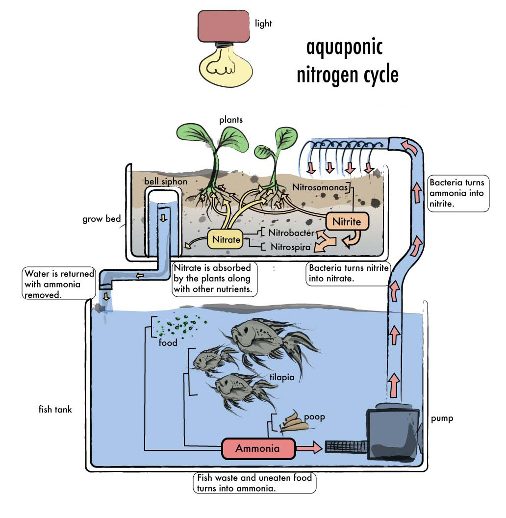
Ignoring this weather mega-drama and Colorado ag’s dependence on irrigation is a relatively new type of farming. Called aquaponics, it combines aquaculture (raising fish) with hydroponics (raising plants without soil) in a controlled, nature-friendly environment. Water is continuously and naturally cleaned, making irrigation issues irrelevant.

The totally organic, closed loop system excludes chemicals and pesticides, relying instead on beneficial insects and pest-deterring plants to combat diseases. Ladybugs and praying mantis introduced into the greenhouse will self-perpetuate.

According to a 2012 Transition Colorado Food Localization study, Colorado’s food purchases exceed $12 billion annually, yet 97 percent of the food consumed is produced out of state.

Within it exist so-called food deserts. For example, Denver’s Elyria-Swansea and Globeville neighborhoods are considered the most polluted in Colorado because of their proximity to heavy industry, an oil refinery, rail yards and a major highway. Factors including distant grocery stores accessible to low-income residents only by public transportation cause or exacerbate health challenges. Fast-food restaurants and food banks provide the only safety net.

Flourish Farms, operated by JD and Tawnya Sawyer, is a 3,250 sq. ft. aquaponics farm inside The GrowHaus, a Denver non-profit urban market, food hub and education center. Flourish donates a portion of its fish and produce to GrowHaus’s local food basket program and market that provide fresh, healthy food to Elyria-Swansea residents.

JD Sawyer confirmed that, in addition to its partnership with GrowHaus, Flourish Farms, also known as Colorado Aquaponics, sells the majority of its green produce and fish to top local downtown Denver restaurants located within five miles of the farm. Just a few hours post-harvest, the food is prepared and served, assuring freshness while maximizing flavor and nutritional value.

Every week of the year, Sawyer’s greenhouse bay at GrowHaus yields an incredible amount of food. Deep water culture beds occupying 1,200 sq. ft. of the bay produce approximately 800-1,000 heads of lettuce, kale, tatsoi, chard, mizuna, mint, basil and a wide variety of other cooking and salad greens. The bay’s 300 sq. ft. devoted to media beds grow squash, zucchini, cucumbers, eggplant, broccoli, Brussels sprouts, beans, strawberries and several varieties of tomatoes and peppers. All these are companion planted with nasturtiums, cilantro and marigolds to deter pests. Recent additions to the media beds in grow-out pots include a Meyer lemon, red bananas, kumquats and a fig tree that boasts more than a 100-year lineage.

Some experts’ gloomy predictions continue to loom about worldwide food shortages. More and more farm acreage is annually lost to development. According to J & J Aquafarms in Sanger, Calif., wild fish stocks will be depleted by 2050. Aquaponics offers one viable solution.

The University of Virgin Islands in St. Croix offers a world-renowned course of study in aquaponics and, for the past 30 years, has been conducting extensive research in its many fascinating facets. Because the island has little fresh water, and because the area has been virtually fished out, it became the perfect living laboratory for aquaponics development.

Tim Schlie of Fort Collins, is owner of Aquaponics Consulting & Enterprise Services (ACES), founded in 2010. After becoming convinced aquaponics is the future of agriculture, he abandoned pursuit of a landscape design degree in favor of aquaponics. In 2008, he earned a Bachelor of Arts degree in Interdisciplinary Liberal Arts from Colorado State University. Following graduation, Schlie travelled to St. Croix for its short course in aquaponics.

Aquaponics’ symbiotic, self-contained ecosystem of plants, fish and bacteria provides a perpetual rather than seasonal harvest. Schlie outlined each component’s role in this cycle.

– Fish: Excrete ammonia through waste. Fish emulsion serves as a fertilizer base. Most freshwater fish can be used in the system, including trout, bass, koi, catfish, tilapia. Each grower should select species that will assure the best income potential in their area. Trout, for example, is a higher-priced commodity than is tilapia. Profit margins can be further heightened by growing fish and fish food right on the farm.

– Bacteria: This component is crucial. Since ammonia is toxic to fish, it must be eliminated; bacteria converts ammonia into nitrites, secondarily into nitrates, then into nitrogen. Plants desire the nitrogen.

– Plants: These clean the system by consuming nitrogen, thereby removing it from the environment. This benefits the fish. Even transpiration from plants can be pumped back into the system. Solid wastes must be removed; “bottom feeders” like catfish, tilapia and jumbo shrimp assist this process. These animals can then be sold to local food markets. Plants that can be successfully grown include most leafy types. However, growers should maximize profit by producing the most desired in their area. Schlie recommended niche products. Chervil, rosemary and thyme are possibilities. Others that thrive are ornamentals and houseplants, berries, melons, cucumbers, basil and beans.

Although units as small as an aquarium for family use are reasonably priced, set-up costs can be extremely high for systems intended for commercial growing. Schlie estimated an entire 30’ x 100’ aquaponics system, including greenhouse, costs approximately $100,000. He reminded that there is, however, zero water loss in aquaponics, whereas traditional farm fields can experience up to 90 percent. The greenhouse is completely contained and self-perpetuating. No plowing, weeding or tilling is required. These differences are key for areas with water restrictions or semi-arid to drought-plagued regions in which people desire locally-grown organic, nutritionally sound foods.

Realistically, who can make money with an aquaponics system? One, said Schlie, is Disneyworld’s Epcot Center, which maintains its own aquaponics system for their restaurant. Small farms and family producers can market their harvests year-round at farmers markets and to local restaurants, organic grocers, etc. Interest in Austin, Texas is huge,Schlie said, due to its very arid climate.

He advised that potential growers should first explore local markets. Perhaps there are no fresh herbs available in winter. Fill that niche. If someone’s ultimate goal is to raise and market aquarium fish, they should consider exotics to fetch the highest dollars. Grow crocuses; Saffron is an aromatic deep orange and fairly expensive powder derived from the flower and used to flavor foods.

Schlie said that people living “off the grid” who produce their own electricity can further self-sufficiency through aquaponics’ production of nutrient-rich, complete meals, i.e. fish, salad and strawberries.

As a relatively new farming model, plenty of room exists for development and creative advances. Aquaponics might someday offer dietary salvation for millions of people trapped in regions of water/ food shortages, or to those living in America’s arid areas or urban food deserts. Is this water-saving system one of agriculture’s biggest waves of the future?

More endangered/threatened species coverage here.

#Drought news: No significant precipitation fell across much of the High Plains, Rockies, and Intermountain West this past week

Click here to go to the US Drought Monitor website. Here’s an excerpt:

Summary

Two low-pressure systems brought significant rains to portions of the contiguous U.S. from the Southern Great Plains to the mid-Atlantic. Elsewhere, most of the rest of the reporting stations around the country reported little to no precipitation, continuing the dry conditions across much of the western states. Moderate rains have brought much needed drought relief to Hawaii, which much of central Alaska remained without precipitation. The eastern portions of Puerto Rico continued to receive light rains, while western portions of the island remain dry…

Southwest

A few stations in New Mexico reported light precipitation (0.01 to 0.15 inch), but most of the Southwest remained dry this week. Westwide SNOTEL reports of SWE much below average across southwest New Mexico and eastern Arizona prompted the expansion of severe drought (D2) across Navajo and Apache Counties in Arizona and Catron County in New Mexico…

The High Plains, Rockies, and Intermountain West

No significant precipitation fell across much of this region during this past week, through the data cutoff time on Tuesday morning. The past week was slightly cooler than average for the Upper Colorado River Basin, and fairly seasonal in terms of precipitation. Another large slug or two of moisture like what was realized at the end of February will be necessary in order for basin-wide snowpack numbers to achieve median status by peak season. East of the divide conditions were much cooler than average and mostly dry with less than a tenth of an inch of precipitation across most of the region. On short timescales eastern Colorado is not at a deficit precipitation-wise with the exception of the northeast corner of the state, which is still holding onto average soil moisture conditions. With the cold temperatures keeping things dormant, lack of substantial winds, and recent snowfall events the recent dryness east of the divide this week should be relatively inconsequential. No changes were made to the drought depiction as precipitation was not far off of normal.

The lack of winter storms across the Great Basin prompted the intensification of drought conditions across eastern Nevada and western Utah. SPI values out through 9 months indicate conditions at least as intense as D1, with shorter time period SPI values indicating even more intense conditions…

The Pacific Northwest and California

The winter continues to be dry for much of this region as no significant rains fell this past week. Abnormally dry conditions expanded across northwest Oregon to near Tillamook. The rest of the area remained unchanged, but will be monitored closely in the coming weeks…

Looking Ahead

Through March 17, two low-pressure systems are forecast to impact the contiguous 48 states during the next 5 days. One is forecast to move across the northern tier while another is forecast to bring significant rains (more than 3.0 inches) to the Gulf Coast and Lower Mississippi Valley. These two systems are forecast to phase over the northeast, with precipitation spreading from west to east across that region. Some flow into the front range of the Rockies, with upper-level support is likely to bring some spring snows to southwest Colorado.

For the ensuing 5 days (Mar 17 -21), below median precipitation is favored along the west coast, and from the Great Lakes to the Southeast, while an upper-level trough supports above median precipitation over the Southwest, most of the Rockies, and portions of the southern and central Great Plains. Western and Southern Alaska are expected to experience an active weather pattern with above median precipitation.

@NatureNews: Do humans deserve their own geologic epoch?

Short and stark: 135 Years of Rising Temperatures in Less Than 30 Seconds via @BBGVisualData

Snowpack news (part 2): The NRCS updated their basin high/low graphs today

@GrandCanyonNPS: Explore wonders of #GrandCanyon Night Sky in new video #ColoradoRiver

Snowpack news

Westwide SNOTEL snow water equivalent as a percent of normal March 10, 2015 via the NRCS

From the Natural Resources Conservation Service (Brian Domonkos):

Two weeks of wet weather through the end of February and beginning of March have provided a significant increase in snowpack statewide and an even greater boost to those southern Colorado basins that are still ailing after several consecutive years of below normal snowpack. Despite substantial accumulations statewide, snowpack has not quite returned to normal, it was 87 percent as of March 1. Further investigation of SNOTEL data indicates that during the nine day period of February 20 through March 1, the state of Colorado received 2.0 inches of snow water equivalent, 181 percent of the normal for that timeframe. That is a 9 percent increase in snowpack percent of median. Preliminary numbers into March indicate an additional 7 percent increase between March 1 and March 5. On March 1, with 20 percent of the mountain snowpack accumulation season remaining, time is dwindling to close the gap and reach typical statewide peak snowpack levels. Brian Domonkos, Snow Survey Supervisor with the USDA Colorado Natural Resources Conservation Service – comments, “While not every major watershed in the state saw snowpack improvements this month, precipitation during the latter half of February was a highly beneficial to many water budgets across the state.”

The recent storm patterns were most beneficial to the Rio Grande watershed, receiving 300 percent of normal snowfall in the last 9 days of February. The South Platte and the Rio Grande both received a 13 percent gain over the course of February. In the South Platte River basin, snowpack, has not reached 2011 or 2014 levels at this point but conditions are still better than 1988, 1993, 1994 and above normal.
Statewide precipitation for the month of February was right at normal, a drastic change from 45 percent of average received during the month of January. Year-to-date statewide mountain precipitation totals increased 3 percent since last month. Colorado reservoir storage increased as well from February 1 to March 1 from 104 to 105 percent of average. Streamflow forecasts saw marked improvements most particularly for the state’s southern streams.

Brian Domonkos put the recent weather into perspective, “This storm could not have come at a better time. Without this storm, if the same weather patterns since January 1 had persisted through spring, mountain snowpack would have narrowly reached only the minimum snowpack peak.”

snowpackreservoirstorage03012015vianrcs

From the Vail Daily (Scott N. Miller):

A March 5 report from the Natural Resources Conservation Service indicates that a two-week spell of wet, snowy weather across Colorado did wonders for the snowpack — which provides not just good skiing, boarding and sledding but water supplies for the next year. Statewide, there was nearly double the snowfall usually received between Feb. 20 and March 1. That snowfall was most pronounced in the southern mountains, coincidentally, the part of the state that most needed a good wallop of white stuff.

GOOD NEWS AT FREMONT PASS

In and around Vail, snowfall in that two-week period wasn’t as substantial as it was in southern Colorado, but the valley still received plenty. Overall, the state received two inches of “snow water equivalent.” Snow measurement sites at Vail, Copper Mountain and on Fremont Pass all received 1.5 inches or more.

That boosted snowpack totals to near, or just above, their historic averages. At Vail Mountain, the total is about 90 percent of average. At Fremont Pass, the total is 117 percent of the historic average.

Diane Johnson, communications and public affairs manager for the Eagle River Water & Sanitation District, said the Fremont Pass numbers are perhaps the most important for the district. The district provides water and sewer service to customers from East Vail to Edwards, with most of those people living west of Dowd Junction. The district can pump water from one end of the district to the other, but the Eagle River provides most of the district’s water supply. With Fremont Pass at the headwaters of the Eagle, that snow field is critical.

MELTING POINT

What’s also critical is when the snowpack starts to melt — the later the better. Early warm weather can mean lower streamflows in late summer and fall. Early warm spells can also result in flooding.

Johnson noted that spring flooding in 2010 wasn’t due to snowfall, but early, sustained warmth. There was actually more snow in 2011, but a cool spring kept flooding to a minimum.

High-elevation snow also doesn’t mean much until it melts. That’s why the U.S. Drought Monitor, a service run by the U.S. Department of Agriculture, classifies the western two-thirds of Eagle County as either “abnormally dry” or in “moderate drought.”

Wendy Ryan, of the Colorado Climate Center at Colorado State University, said while snowpack numbers improved — greatly in some areas — the drought classifications didn’t change much due to the wet weather in February and early March.

If the current stretch of warm weather holds — the forecast for Vail shows warm temperatures and only a slight chance of precipitation during the next five to seven days — Eagle County and the state might be in some trouble. Snowpack numbers still need to be climbing.

But the good news is that climate predictions contain some moisture. Ryan said that the forecast into the week of March 23 shows a good chance of above-average precipitation for most of the western U.S. The 90-day forecast also holds a decent chance of above-average precipitation.

Also, for the past couple of weeks, temperatures have cooled from the record highs seen in early February, Ryan said.

That’s what’s going to be needed.

“We hope to see an above- average March and April,” Ryan said.

While there’s still about a month left in the ski season, Johnson said she understands those who are yearning for the seasons to change.

“But we need a lot of winter still,” Johnson said. “We need the snow up high, and it needs to stick around.”

From the Summit Daily News (Ali Langley):

“While not every major watershed in the state saw snowpack improvements this month, precipitation during the latter half of February was highly beneficial to many water budgets across the state,” said Brian Domonkos, snow survey supervisor with the USDA Colorado Natural Resources Conservation Service.

The four SNOTEL sites in Summit County measured snowpack in the Blue River Basin on Tuesday, March 10, at 109 percent above the median.

That’s a slight drop in the snowpack percent above normal for the date compared with readings from early February.

Statewide precipitation for the month of February was normal, a drastic change from the 45 percent of average received during January.

“Without this storm, if the same weather patterns since Jan. 1 had persisted through spring, mountain snowpack would have narrowly reached only the minimum snowpack peak,” Domonkos said.

Despite the accumulations, statewide snowpack has not quite returned to normal. As of March 1, it was 87 percent of the 30-year average.

Further investigation of SNOTEL data indicates that during the nine-day period of Feb. 20 through March 1, the state received 2 inches of snow-water equivalent, or 181 percent of normal for that time frame.

That 2 inches also represents a 9 percent increase in snowpack percent of median with an additional 7 percent increase arriving between March 1 and March 5. On March 1, with one-fifth of the mountain snowpack accumulation season remaining, snow surveyors said time is dwindling to close the gap and reach typical statewide peak snowpack levels.

STATE’S RIO GRANDE WATERSHED BENEFITS

The recent storm patterns were most beneficial to the Rio Grande watershed, which received 300 percent of normal snowfall in the last nine days of February. The Rio Grande and South Platte watersheds both received a 13 percent gain over the course of February.

In the South Platte River basin, snowpack has not reached 2011 or 2014 levels, but conditions are still above normal and better than in 1988, 1993 and 1994.

Forecasters predict a chance of snow Thursday and Friday for the High Country, followed by dry, warm weather through early next week.

From The Mountain Mail (Brian McCabe):

While Arkansas River Basin snowpack is up to 101 percent of median as of March 1, Colorado remains below normal statewide, at 87 percent of median, the Natural Resources Conservation Service reported Thursday.

Wet weather the state received for about 2 weeks in late February and early March significantly increased the snowpack, especially the southern basins, which are still having difficulties after several years below normal, the NRCS stated.

In the 9-day period between Feb. 20 and March 1, Colorado received 2 inches of snow water equivalent, which is 181 percent higher than normal for that time period. That resulted in a 9-percent increase in the snowpack percent of median.

NRCS officials said preliminary numbers indicated a 7-percent increase between March 1 and 5, but as of March 1, only 20 percent of the mountain snowpack accumulation season remains.

“While not every major watershed in the state saw snowpack improvements this month, precipitation during the latter half of February was highly beneficial to many water budgets across the state,” Brian Domonkos, snow survey supervisor with Colorado NRCS, said.

The February storm benefited the Rio Grande watershed most, which received 300 percent of normal snowfall in 9 days. The South Platte and Rio Grande watersheds received a 13-percent gain.

While statewide precipitation for February was normal, January precipitation was 45 percent of average.
The year-to-date totals for statewide mountain precipitation increased 3 percent last month, while reservoir storage increased from 104 to 105 percent from Feb. 1 to March 1.

“This storm could not have come at a better time,” Domonkos said. “Without this storm, if the same weather patterns since Jan. 1 had persisted through spring, mountain snowpack would have narrowly reached only the minimum snowpack peak.”

From The Grand Junction Daily Sentinel (Dennis Webb):

Recent storms have helped Colorado’s snowpack rebound from a dry January, especially in the southern part of the state.

The Natural Resources Conservation Service said Friday that the statewide snowpack was up to 87 percent of normal as of March 1, from 83 percent a month earlier.

It rose further, to 92 percent, by Friday.

The agency said that from Feb. 20 through March 1, the state received 2 inches of snow water equivalent, or 181 percent of normal over those nine days.

Brian Domonkos, snow survey supervisor with the U.S. Department of Agriculture’s Colorado Natural Resources Conservation Service, said in a news release, “While not every major watershed in the state saw snowpack improvements … precipitation during the latter half of February was highly beneficial to many water budgets across the state.”

That particularly goes for the Upper Rio Grande watershed, which during the last nine days of last month received three times the normal snowfall it gets in that time.

Southern Colorado basins have experienced several consecutive years of below normal snowpack.

The Upper Rio Grande basin had climbed to 87 percent of median on Friday, while the San Juan/Animas/Dolores/San Miguel watershed was still at 75 percent.

The Upper Colorado River Basin was at 97 percent Friday; the Gunnison, 84; the Yampa/White, 87; and the Arkansas, 103. The South Platte led the way at 112 percent of median, and the Laramie/North Platte was at 94 percent.

The conservation service said February’s precipitation was right at normal for the month, compared to 45 percent of average in January.

Statewide reservoir storage is at 105 percent of average, up a percent from Feb. 1, and the conservation service said streamflow forecasts also are markedly improved, especially in southern Colorado.

Upper Colorado River Basin reservoir storage was at 120 percent of normal on March 1; the Gunnison, 111 percent; the Yampa/White, 122; the Upper Rio Grande, 72; and the San Juan/Animas/Dolores/San Miguel, 89.

Despite the recent improvements, the Natural Resources Conservation Service noted that time is dwindling to close the remaining gap and reach typical statewide peak snowpack levels.

The start of March means that 20 percent of the mountain snowpack accumulation season remains.

From InkStain (John Fleck):

April-July runoff into Lake Powell, the big reservoir in the Colorado River’s “Upper Basin”, is forecast to be 71 percent of average, according to the Colorado Basin River Forecast Center. There’s still a one in ten chance, if things get wet over the next month, that we could have an average year. But with another lost month, the chances on the wet side of the probability distribution no longer leave much room for enough excess runoff to bail out the river system’s shrinking reservoirs.

On the bad side, the “one in ten” forecast on the dry side, the worst case scenario, is for 48 percent of average.

Weekly Climate, Water and Drought Assessment of the Upper #ColoradoRiver Basin

Upper Colorado River Basin month to date precipitation March 1 thru March 8, 2015

Click here to read the current assessment. Click here to go to the NIDIS website hosted by the Colorado Climate Center.

More Colorado River Basin coverage here.

Long Hollow reservoir filling — The Durango Herald

Long Hollow location map via The Durango Herald

From The Durango Herald (Dale Rodebaugh):

Rain and snowmelt have provided the first water for a reservoir on Long Hollow Creek near Redmesa, a long-planned storage unit that will help Colorado meet its contractual water obligation to New Mexico and indirectly provide water for irrigators in southwest La Plata County.

Construction was completed in June 2014 on the Bobby K. Taylor Reservoir, named for the late rancher whose land is now disappearing under the advancing water. When full, the reservoir will be a lake one-mile long.

Flow from Long Hollow Creek and Government Draw fills the reservoir, which has a capacity of 5,300 acre-feet.

“We had 385 acre-feet this morning,” Brice Lee, chairman of the La Plata Water Conservancy District, said Tuesday. “It’s not as much as we’d like, but we’ll take it.”

Colorado shares La Plata River water 50-50 with New Mexico, but the erratic flow makes fulfilling the obligation problematical. Now, Taylor Reservoir water can be released to the La Plata River a mile away for New Mexico consumption, and this will allow Colorado irrigators to take water from the La Plata River.

Construction of the reservoir was on a tight budget. When the Animas-La Plata Project, the last major water work in the West, was downsized in the 1990s, water for irrigation was eliminated.

Long Hollow project advocates patched together a financing plan. They acquired $15 million the Colorado Water Resources and Power Development Authority had set aside for projects in the area, got $3 million from the Ute Mountain Ute tribe and, finally, $1.6 million from the state Legislature last year.

More La Plata River watershed coverage here.

Republican River Basin: Nebraska, Kansas and Colorado continue cooperation with water agreement — McCook Gazette

South Fork of the Republican River

From the Republican River Compact Administration via the McCook Gazette:

Today, reflecting the continued spirit of cooperation, Colorado, Kansas and Nebraska, along with the U.S. Bureau of Reclamation, have reached an agreement that will ensure more certainty to the basin’s water users in both Nebraska and Kansas. The agreement, signed through the Republican River Compact Administration (RRCA), was achieved through collaborative negotiations that began in January 2015 and will provide timely access to water for the 2015 irrigation season.

The agreement provides additional flexibility for Nebraska to achieve its Compact obligations while ensuring Kansas water users’ interests are also protected. The additional flexibility allowed the Nebraska Department of Natural Resources to open Nebraska reservoirs and water user’s rights that were initially limited in 2015. Opening the Nebraska water rights allowed the Bureau of Reclamation to agree to modify certain contract provisions for its irrigation districts, ensuring the availability of the water that was pumped from Nebraska augmentation projects for Compact compliance.

Additionally, the agreement allows for the Nebraska Department of Natural Resources to ensure no additional regulatory water supply reductions for Nebraska surface water irrigation user’s water supplies for the 2015 irrigation season.

Current RRCA Chairman Jim Schneider, Acting Director of the Nebraska Department of Natural Resources, said, “This is a significant step forward for the states and our water users. Our collaborative work and this agreement further demonstrate the benefits of the recent cooperation that the states have been able to achieve. I am optimistic that the states and Bureau of Reclamation can work toward ensuring these types of arrangements can be in place each year so that both Nebraska and Kansas water users will secure the benefits of having more certainty in their water supplies.”

Kansas Commissioner David Barfield said, “Today’s agreement continues to move us forward toward a longer-term solution benefiting the basin’s water users. I appreciate not only Nebraska’s continued willingness to work through these issues, but also the Bureau of Reclamation and its irrigation districts for their part in reaching today’s agreement.”

Colorado Commissioner Dick Wolfe said, “These recent agreements are emblematic of the new cooperation among the states and the federal government. I hope it continues to be a model for cooperation and successful settlement of the remaining issues within the basin.”

At the Nov. 19, 2014, meeting in Manhattan, Kansas, the states reached an agreement that provided Nebraska with 100% credit for water delivered from augmentation projects to Harlan County Lake prior to June 1, 2015, and dedicated that water to be used exclusively by Kansas irrigators.

The RRCA is comprised of one member each from the States of Colorado, Kansas and Nebraska. The purpose of the RRCA is to administer the Republican River Compact. This Compact allocates the waters of the Republican River among the three states. The next RRCA meeting is scheduled for August to be hosted in Lincoln, Nebraska.

More Republican River Basin coverage here.

John Fleck’s water news is out — California’s great drought experiment #ColoradoRiver @jfleck

Sandhill Cranes making spring migration through the San Luis Valley; Festival this weekend — CPW

Frome email from Colorado Parks and Wildlife:

The annual spring migration of greater sandhill cranes is in full force in southern Colorado. If you’ve never seen this beautiful event, be sure to put it on your bucket list.

“People in Colorado should take time to see the cranes; the migration is truly one of nature’s wonders,” said Rick Basagoitia, area wildlife manager for Colorado Parks and Wildlife in the San Luis Valley.

The annual San Luis Valley Crane Festival is scheduled for this weekend, March 13-15.

The cranes start arriving in late-February, flying from their winter nesting grounds, primarily in New Mexico. The large wetland areas, wildlife refuges and grain fields in the San Luis Valley draw in about 25,000 birds. The cranes stop in the valley to rest-up and re-fuel for their trip north to their summer nesting and breeding grounds in Idaho, Montana and Wyoming.

Cranes are among the oldest living species on the planet: Fossil records for cranes date back 9 million years. The birds that migrate through Colorado are the largest of the North American sandhill subspecies standing 4-feet tall with a wing-span of up to 7 feet and weighing in at 11 pounds. Besides their imposing size, the birds issue a continuous, distinctive and haunting call. At this time of year cranes are engaged in their mating ritual and the birds perform an elaborate and elegant hopping dance to gain the attention of other birds.

The birds are most abundant at the Monte Vista National Wildlife Refuge, located 6 miles south of the town of Monte Vista on Colorado Highway 15. The birds also are easily seen in farm and ranch fields around Monte Vista.

Wildlife watchers can also see the birds at the Alamosa National Wildlife Refuge located southeast of the town of Alamosa, and at the Rio Grande, Higel and Russell Lakes state wildlife areas. Plenty of birds can also be seen in the many agricultural fields near Monte Vista and Alamosa.

The cranes are most active at dawn and at dusk when they’re moving back and forth from their nighttime roosting areas. Be sure to dress warm as temperatures can be very cold in the valley.

During the three days of the festival, free tours are offered at 7 a.m. and 4 p.m. when the birds are most active. Visitors take buses to various spots on the wildlife refuge, and local experts talk about the migration and the refuge. If you want to take a tour, be on time because the buses leave promptly.

The festival headquarters and starting point for the tours is the Ski Hi Park building located near U.S. Highway 160 on Sherman Avenue on the east side of Monte Vista. Visitors can pick up maps, schedules and information at the headquarters.

Besides the tours, a variety of workshops are put on by bird, wildlife and photography experts. An arts and crafts fair continues through the weekend at the headquarters building. The crane festival is organized by the local crane festival committee, with help from the Colorado Parks and Wildlife, the U.S. Fish and Wildlife Service, Rio Grande County, SLV Ski Hi Stampede, Monte Vista school district, and the city of Monte Vista.

The number of cranes in the valley peaks in mid-March and many linger through the month. So even if you can’t go the weekend of the festival there’s still plenty of time to see the birds.

Birdwatchers who travel on their own should be cautious when parking, getting out of vehicles and walking along roads. People are also asked to view birds from a distance with binoculars and spotting scopes, and to observe trail signs and closure notices.

Many other bird species – including eagles, turkeys and a variety of waterfowl – can also be seen throughout the San Luis Valley.

Approximate distances to Monte Vista: Denver, 220 miles; Colorado Springs, 182 miles; Salida, 85 miles; Vail, 175 miles; Durango, 135 miles; Grand Junction, 230 miles.

For more information on the Monte Vista Crane Festival, see: http://www.cranefest.com.

To learn more about sandhill cranes, see: http://cpw.state.co.us/learn/Pages/SpeciesProfiles.aspx.

For more information on State Wildlife Areas in the San Luis Valley, go to: http://wildlife.state.co.us/LandWater/StateWildlifeAreas/Pages/swa.aspx.

For more information about the San Luis Valley wildlife refuge complex, see: http://www.fws.gov/refuge/monte_vista.

21 Favorite Ways to Save Water – Jain Irrigation Inc. via @DenverWater

Governor’s Ag Forum recap

Governor Hickenlooper, John Salazar and John Stulp at the 2012 Drought Conference

From The Greeley Tribune (Kayla Young):

Gov. John Hickenlooper addressed Colorado’s agricultural community [February 26, 2015] in full Western style, donning a black Stetson cowboy hat for the annual Governor’s Forum on Colorado Agriculture at the Renaissance Hotel.

While the variation from the governor’s typical attire lightened the mood, the day touched on some of the most serious issues affecting the future of agriculture.

Water reigned as the topic of the day, carrying through not only Hickenlooper’s presentation, but also the day’s panel discussion led by 7News meteorologist Mike Nelson and the keynote speech by the governor’s water adviser, John Stulp.

Hickenlooper lauded the Colorado State Water Plan as vital to creating long-term security and better preparing the state for the challenges of climate change.

Stulp described the plan as achieving five major goals: fostering collaborative solutions to address the state’s looming supply gap, creating alternatives to the buy and dry of agricultural lands, protecting Colorado’s compact entitlements, pushing federal regulators to move more quickly on approval processes, and aligning state policies with dollars.

Stulp applauded the basin roundtable discussions that contributed to much of the legwork behind the water plan for bringing together diverse state interests that “would have otherwise only gotten together in a courtroom to sue each other.”

With Hickenlooper looking to expand international exports in agriculture, water security will play a key role in establishing confidence and capacity to move forward.

“Ag is one of the leading, if not the leading, industries in the state,” Hickenlooper said.

To bolster the sector further, he encouraged the passage of the Trans-Pacific Partnership to expand export markets for beef and pork. The proposed treaty would expand trade routes for U.S.-made goods in Asia, the Pacific and Latin America.

Hickenlooper also praised the Colorado Agricultural Leadership Program for bringing new advocates into the sector, and the Western Dairy Association for its efforts to afford veterans opportunities in agriculture.

Earlier in the day, a lively panel discussion led by Nelson touched on national, statewide and local water challenges, addressed by panelists Robert Sakata, Carlyle Currier, Reagan Waskom, Greg Fisher and Bart Miller.

The panel captured the complexity of Colorado’s state water laws, which often translate to decades of work to conclude infrastructure projects. With concern over excess flows entering Nebraska and potential calls on the Colorado River by western neighbors, one audience member asked why the state is not able to create more storage areas.

Waskom, director of the Colorado Water Institute, said uncertainty often leads well-intended projects off course.

“We see participants pull out because they’ve been putting money in and they don’t know if they’re going to get the storage in the end,” he said.

Greg Fisher, manager of demand planning for Denver Water, said, while additional storage would help, the state needs to look at supply development holistically.

“Storage will help, but we must take an all-of-the-above approach: conservation, reuse, storage, and you have to do all of it now,” Fisher said.

The panel differed on its opinions regarding the overall water use from fracking operations.

Waskom said the estimated 20,000 acre-feet of water that goes into hydraulic fracturing on the South Platte represents a drop in the bucket for the capacity of the river. Most of the water comes from systems such as Greeley’s that permit multiple use, which avoids additional demand.

One acre-foot of water is enough to serve four homes for a year.

Bart Miller, water program director for Western Resource Advocates, said while 20,000 acre-feet may not sound like a lot, when compared to the enormous cost of creating storage for such water, the quantity does equate to a meaningful amount in the grand scheme of things.

The panel also turned to the high groundwater levels damaging homes and farmland around Gilcrest and LaSalle in Weld County.

While Waskom said he has been living this drama for a decade, the water expert could not provide an easy solution.

“This is a really hard one to solve without someone getting harmed,” he said. “This is a classic Colorado water fight.”

While unity served as a recurring theme, discussion over Weld’s groundwater headache served as a reminder that on many water issues, cohesive solutions have yet to be found.

2015 Colorado legislation: Microbead ban (HB15-1144) passes on unrecorded voice vote #coleg

Putting the electric harness on old dams — the Mountain Town News

From the Mountain Town News (Allen Best):


Pueblo dam releases
Pueblo dam releases

State and federal incentives together producing new power from old dams

As with most smaller dams from that era, no hydroelectric turbines were installed in Pueblo Dam when it was constructed during the early 1970s. It’s located in central Colorado, the silvery summit of Pikes Peak in the distance, impounding the Arkansas River as it meanders onto the Great Plains.

The dam’s 191 feet height provides what hydrologists call head, a prerequisite for making large amounts of electricity. Absent, though, are large volumes of water.

Now, with strong financial and other incentives from both the state and federal governments, dam operator Southeastern Colorado Water Conservancy District seeks to install turbines sufficient to allow production of 7 megawatts.

Five such retrofits in the West have occurred since 2008. Pueblo and 18 others are in the pipeline. Many are in Colorado, which has emerged as a model for how to encourage the retrofitting of smaller, older dams.

Retrofitting Colorado dams and canals

  • Ridgway Reservoir (8 MW): completed 2014
  • Carter Lake (2.6 MW): completed 2013
  • South Canal Drops 1 and 3 (7.5 MW): completed 2013
  • Lake Granby (1.2 MW): underway
  • Pueblo Reservoir (7 MW): underway
  • Shavano Falls (2.8 MW): underway
  • South Canal Drop 2 (1 MW): underway

Michael Pulskamp, who oversees the U.S. Bureau of Reclamation’s lease-of-power-privileges program from an office in suburban Denver, says the 2005 Energy Bill required resource assessments of federal water infrastructure but the Obama administration delivered the push.

Those studies found great cumulative potential. A 2011 study concluded that one million megawatts of annual production of electricity could be delivered if just the 70 most promising dams, diversion structures, and tunnels were developed. The study had screened 530 federal sites.

Colorado, Utah, Montana, Texas, and Arizona have the most sites with hydropower potential.

“That study really laid out that we weren’t tapped out in terms of hydropower potential,” says Pulskamp.

Another federal assessment of 373 irrigation canals, tunnels, and other conduits in 13 Western states found another potential 103.6 megawatts of generating capacity.

Even if all the 1.1 million potential megawatts identified in the two studies get built, the capacity will be dwarfed by existing dams in the West. Grand Coulee Dam, completed on the Columbia River in 1941, produces 21.5 million megawatts annually, tops in the West. Glen Canyon Dam, on the Colorado River, can produce 3.8 million megawatts, followed closely by Hoover Dam with 3.7 million.

Shasta Dam, in California, can produce 1.9 million megawatts and Davis Dam, on the Colorado River in Arizona, produces 1.1 million megawatts.

Ridgway Dam
Ridgway Dam

Colorado’s largest hydroelectric production comes from the three dams on the Gunnison River in what is called the Aspinall Unit. Together, they can produce 826,000 megawatts annually. Hydroelectric capacity installed in several components of the Colorado Big-Thompson diversion project can collectively produce 413,000 megawatts.

In comparison, new turbines on Utah’s Jordanelle Dam can produce 39,000 megawatts annually while Colorado’s Ridgway Dam, which went on line last May, can produce 22,000 megawatts annually.

Pueblo will produce even less, 19,700 megawatts annually. Southeastern Water was prodded into taking on the project only after the Bureau of Reclamation specifically solicited proposals.

“We were afraid if we didn’t pursue it, a private entity might come and develop the project,” says Kevin Meador, project manager for Southeastern Colorado Water. The Pueblo-based agency administers water diverted to the Arkansas from the Aspen area under federal sponsorship in the Fryingpan-Arkansas Project.

Colorado’s state government has provided both financial incentives and a market for sale of renewable energy. One of the incentives is a 2 percent loan at 30 percent from the Colorado Water Conservation Board. “That is a huge factor in making this project feasible,” says Meador.

The Colorado Water Resources and Power Development Authority also provides 20-year loans of 2 percent.

In setting a 30 percent renewable portfolio standard for investor-owned utilities and now a 20 percent standard for Tri-State Generating & Transmission, Colorado has created a market for power from smaller dams. No buyers for the electricity from Pueblo have been lined up, but Meador says his agency needs to get 3.5 to 4 cents per kilowatt hour to make the numbers work.

If this were Massachusetts or Hawaii, where electricity prices to consumers run up to 25 cents per kilowatt hour, that would be an easy sell. But in the Rocky Mountains, energy has historically been relatively cheap, observes Meador, “and these hydro projects are capital intensive. They are very expensive up front.”

Seven percent of all U.S. electricity comes from hydropower. In Colorado, it’s 4 percent. Pulskamp says that the greatest hydroelectric potential lies in further harnessing the slow-moving but vast quantities of water in the Mississippi River and its tributaries. His agency, however, has little oversight there.

Kurt Johnson, president of the Colorado Small Hydro Association, says Colorado could serve as a model for other states. He points to efforts begun in the administration of former Gov. Bill Ritter to surmount an often clunky, discouraging federal permitting process. Even more important, Colorado has sweetened incentives with low-cost, long-term loans. Finally, last year it lowered regulatory hurdles.

Two key federal laws passed by Congress in 2013 simplified the federal regulatory process. One law specifically targeted Bureau of Reclamation facilities. Johnson’s organization now seeks to lower the hurdle for other existing but non-federal facilities that must get approval from the Federal Energy Regulatory Commission.

Despite the recent growth, however, hydroelectric remains just a small part of new electrical generating capacity, both in the West and nationally. In 2015, gas was responsible for the most new generating capacity, followed by wind and solar. Hydro was just 1 percent of total national production.

Granby Dam via Reclamation

Yet even with just trickles of water, hydro power now makes sense financially. Consider Granby Dam, which plugs the Colorado River a few dozen miles from the river’s origins in Rocky Mountain National Park. The dam is 298 feet tall, providing plenty of head. Like Pueblo, it lacks water: just 20 cubic feet per second of water gets released during winter months, as required for environmental purposes, and 75 cfs during summer, except in the biggest of runoff years. The rest gets diverted to cities and farms east of the Continental Divide.

With so little water, Granby can generate just 1/800th of the total production of Hoover Dam. That small production, along with competition from cheap power, is why turbines were never installed when the dam was built from 1941 to 1950.

“Probably power sale rates were next to nothing,” says Carl Brouwer, a project manager for Northern Water, the water agency that distributes Colorado-Big Thompson water to the Boulder-Greeley-Fort Collins area.

As with Pueblo, Northern Water had first shot at obtaining the lease to produce power and did so to preclude shared operations. Northern was aware of at least one other bidder, says Brouwer.

Granby also needed the state’s $5.1 million loan at 2 percent interest is crucial in moving the $5.8 million project forward. “That low-interest loan is what makes this project feasible,” says Brouwer.

A smaller revenue stream comes from sale of the environmental attributes of the energy through a financial device called renewable energy certificates, or RECs. Purchaser was Tri-State Generation & Transmission.

Annual revenues, projected to be $375,000, will pay off debt and operations during the first 30 years. But unlike coal-fired power plants, the supply of fuel will always be free.

More hydroelectric/hydropower coverage here.

USGS: Wonder what this Magnolia Warbler sounds like? Listen to its song & 150+ others.

USGS: Groundwater Atlas

Planning for Fort Collins’ future water needs — Kevin Gertig

Halligan Reservoir
Halligan Reservoir

From the Fort Collins Coloradoan (Kevin Gertig):

Fort Collins is located in a semi-arid region where the amount of water available from month to month and year to year varies, especially during dry years and drought. Fort Collins Utilities has a responsibility to provide an adequate supply of water to existing and future customers; we made long-term water supply an essential element of our planning efforts decades ago.

For more than a century, Utilities has used an integrated approach to manage our water supply, including:

•Securing senior rights on the Poudre River,

•Purchasing and improving an existing storage facility on the upper Poudre (Joe Wright Reservoir),

•Acquiring nearly 19,000 units of the Colorado-Big Thompson Project, and

•Establishing water conservation programs beginning in the late 1970s.

Recent updates to the Water Supply and Demand Management Policy, which provides direction to meet our community’s future water demands, identified the need for additional long-term water storage. Though the community actively conserves water year-round, storage is a valuable tool in water resources planning. Adequate storage helps meet projected demands and provides reserves for unexpected events, including pipeline failure, fires in the watershed or issues with Horsetooth Reservoir.

This policy also references Utilities’ Water Conservation Plan, which lays out a significant expansion of the water conservation program and targets residential and commercial customers, as well as indoor and outdoor water use.

Water conservation helps ensure the wise use of available water, especially during dry, hot summer months when little moisture is available. Although conservation helps stretch our water supply, Utilities’ current limited storage capacity means conserved water cannot be stored for future use.

If the Halligan Water Supply Project is permitted by the U.S. Army Corps of Engineers and approved by City Council, it will help meet Fort Collins’ future water needs. Careful planning and analysis determined that enlarging Halligan Reservoir is one of the most cost-effective solutions that minimizes environmental impacts compared to constructing a new one. The project also will provide storage of mostly existing water rights and be tailored in size and operations for our specific needs.

Fort Collins Utilities is proud of its strong conservation ethic, which provides a solid foundation for the management of our current and future water use in the Poudre River Basin. Through continued conservation efforts, smart water management and additional storage capacity, such as the Halligan Water Supply Project, Utilities will be prepared to meet the future water needs of our community.

For more information, visit http://fcgov.com/halligan.

More South Platte River Basin coverage here.

The water czar who reshaped Colorado River politics — High Country News #ColoradoRiver

Pat Mulroy via The Earth Institute at Columbia University

Here’s an in-depth look at Pat Mulroy and her role shaping Colorado River politics and leading the Southern Nevada Water Authority into the 21st Century, from Matt Jenkins writing for the High Country News. Click through and read the whole article. Here’s an excerpt:

In 1985, Mulroy became deputy general manager of the Las Vegas Valley Water District, one of seven water agencies that supply Vegas and its suburbs. By 1989, she was general manager — and found herself with a fight on her hands. The seven agencies were running out of water and squabbling over what remained. “Southern Nevada was in meltdown,” she says. “It was acrimonious and ugly.”

It took three years to find “peace and a pathway forward,” as she puts it, by convincing the other agencies to cooperate under the banner of a new superagency called the Southern Nevada Water Authority, whose primary goal would be to ensure water supplies for the entire metropolitan area. From the start, it was clear that Mulroy would be in charge. “There was no way in hell,” says George Forbes, then Boulder City manager, “that she was going to play Number Two to anybody.”

Then Mulroy turned outward. In the 1920s, when the Colorado River was originally divvied up, Las Vegas was little more than a railroad stop, and Nevada was a sparsely populated desert. The other six states that share the river received nearly all the water — and the power. Mulroy was determined to change that by challenging the so-called “law of the river,” an amalgamation of more than four-dozen statutes, international treaties and court decrees that other states’ managers adhered to, Mulroy notes sarcastically, as if they were Moses’ tablets. With southern Nevada’s warring agencies now united, Mulroy was ready to take on the other states. “When we said something,” she says, “they knew we meant it.”

For his part, Bunker likens Mulroy’s entrance into the broader realm of Colorado River politics to unleashing “a flash-bang grenade” on a bunch of “old, mossback, gray-headed guys.”

Mulroy’s grand entrance came at a critical time for Las Vegas, which was well on its way into a major boom. In 1992, when Mulroy took charge of the Water Authority, roughly 840,000 people lived in the metropolitan area. Over the next decade, that number would nearly double. By 2002, Mulroy fully expected to have hit the limits of Nevada’s full Colorado River allocation of 300,000 acre-feet — roughly 98 billion gallons per year — even as the city continued to swell.

So she launched a campaign to wrest more water from the Colorado. Roughly 70 percent of the river’s water is used for agriculture, and many urban water agencies see that as a reservoir on which they might draw if necessary. But there’s very little farming in southern Nevada, so Mulroy was forced to look toward other states. This was sacrilege in a system where each state traditionally guarded its own allocation of the river as if it was more precious than gold.

Her sights eventually fell on Chevron, which held rights to water that it hoped to use to extract oil shale in western Colorado. The company needed a way to put the water to use until the shale industry took off. One way to do that might be by leasing it to Las Vegas.

That, however, would run headlong into a hallowed proscription in the state of Colorado. Owing to the structure of the law of the river, the upstream, Upper Basin states — Colorado, Wyoming, Utah and New Mexico — and their downstream, Lower Basin counterparts — Nevada, Arizona and California — form two separate negotiating blocs, which are set squarely in opposition to each other on key legal controversies. And Colorado officials have long maintained that, under the law of the river, transfers between the Upper and Lower basins are illegal.

Though it would be decades before Colorado needed its full river allocation, officials there saw Chevron’s water as critical to the state’s future economic development. If Las Vegas came to depend on the water, they feared, Colorado might lose its rights through a sort of adverse possession.

So when Jim Lochhead, a strategy advisor for Colorado, heard about Mulroy’s negotiations with Chevron, he quickly booked a flight to Vegas and delivered a warning: Back off. “She would have gotten years and years of litigation,” Lochhead said last year. “And she wouldn’t have gotten any water.”

Mulroy turned her attention to the safer territory of the Lower Basin. Water managers there were already bandying about a series of interstate “banking” proposals, under which the states could store water for each others’ use. Both Arizona and California were interested, but Nevada’s need was urgent.

Finally, in 2001, Mulroy got what she wanted: The Southern Nevada Water Authority inked a deal under which it would pay a counterpart in Arizona to buy water from farms there and store it underground. In return, the Water Authority could, in later years, take an equivalent portion of Arizona’s share of the Colorado River directly from Lake Mead, the massive reservoir just east of Las Vegas from which the city already draws most of its water.

Though it was pitched as a banking deal, it was really an exercise in figuring out how to move water across state lines. “If you think about it, it’s pretty much the exact same thing as us going to Arizona and buying water and moving it to Nevada,” says David Donnelly, who was Mulroy’s engineering and operations chief and the principal architect of this deal. “Except in this case, Arizona buys it, takes the water and banks it for us — and then we get it back in the future.”

It was also the first federally sanctioned deal for a water transfer between two states. But Mulroy has only ever spoken about it euphemistically because transfers, even within the Lower Basin, are so politically charged. “Don’t ever call it a transfer,” she scolded during a 2008 interview. “It’s a banking agreement. That thing will disappear on us tomorrow if we call it a transfer.”

She had learned a crucial lesson, however. In the years that followed, Mulroy would — despite her reputation as a woman who didn’t mince words — speak an increasingly convoluted lingua franca that would eventually include enigmas like “intentionally created unused apportionment.” It sounds like gobbledygook, but it was all for a larger end.

“I learned it’s not what you do, it’s what you call it,” Mulroy told me. “You find the right name for it, and you can do anything.”

The opaque language bought managers leeway to try new approaches within the arcane system of interstate water management on the river. That helped Mulroy in her quest for water to sustain Vegas’ runaway growth. Ultimately, however, it would help all the Colorado River water bosses weather a much bigger looming disaster.

More Colorado River coverage here.

EPA: Do you want to help your local waterways this spring? See how you can help prevent nutrient pollution.

Article VII of the Rio Grande Compact — John Fleck

Pond on the Garcia Ranch via Rio Grande Headwaters Land Trust

From Inkstain (John Fleck):

Article VII of the Rio Grande Compact is one of the keys to allocating the river’s supply among Colorado, New Mexico, and Texas:

Neither Colorado nor New Mexico shall increase the amount of water in storage in reservoirs constructed after 1929 whenever there is less than 400,000 acre feet of usable water in project storage….

Operationally, this is critical. It means that in drought conditions, irrigators cannot store spring runoff in essentially all upstream reservoirs for summer use. There’s been some flexibility written into the law in practice, but it only operates at the margin. It basically means that during droughts, one of the water managers’ most important tools (storage) is constrained.

More Rio Grande River Basin coverage here.

Republican River agreement increases some water supplies for irrigation — the Scottsbluff Star-Herald

Republican River Basin by District

From the Scottsbluff Star-Herald (Lori Potter):

Some surface water irrigators in Nebraska’s part of the Republican Basin will get more water for their 2015 crops than originally expected as a result of an agreement signed Friday through the Republican River Compact Administration…

A key part of the agreement allows water to be released from Nebraska reservoirs earlier than planned for irrigation, even if that means being out of compact compliance.

Acting Nebraska Department of Natural Resources Director Jim Schneider said Nebraska will be allowed to make up the difference in fall 2015 or spring 2016 with surface water administration and/or water from two natural resources district projects that pump groundwater into tributaries to enhance Republican River flows into Kansas.

Schneider said that before the agreement, Nebraska officials were being very conservative in water administration to ensure 2015 compact compliance, with water likely held in reservoirs until late summer.
Nebraska water rights for irrigation were opened in July 2014, which was too late for farmers to make crop plans based on having water. “It (2015) probably would have looked a lot like that,” Schneider said.

For the 22,455 acres of the Nebraska Bostwick Irrigation District downstream of Harlan County Lake, primarily in Franklin, Webster and Nuckolls counties, that meant a water supply equivalent to about 2.5 inches of water per acre.

District Manager Mike Delka of Red Cloud told the Hub that Friday’s agreement will increase that to 5 inches per acre.

Frenchman-Cambridge Irrigation District Manager Brad Edgerton said the main effect in his district will be downstream of Swanson Reservoir, where 20,000 acres from Trenton to the Indianola area along the Meeker-Driftwood Canal will get a boost from 1.5 inches per acre to 6 inches.

“This won’t be a full supply,” Schneider said, “but it will be the difference between being worth it to (irrigate) or not to take any water at all.”

For the irrigators, an earlier agreement would have been better. “The big advantage is knowing what you’re doing going into a crop year, so we would have liked to have known sooner,” Edgerton said.

Schneider said the incentive for Kansas officials to sign the agreement is that Kansas Bostwick Irrigation District irrigators have a certain 2015 water supply for 9 inches per acre.

Delka said Nebraska Bostwick and Frenchman-Cambridge officials started looking at options when it was clear 2015 would be another “compact call” year, with water to fill the irrigation districts’ needs being held in the reservoirs.

Delka said he, Edgerton and Kansas Bostwick Manager Kenny Nelson met with Bureau of Reclamation officials at a January meeting in Colorado.

“We said this is a third year of a compact call. This is just going to continue forever. We can’t afford that,” Delka said.

Work then began to identify how much water was needed to put Nebraska into compact compliance so the compact call could be lifted.

DNR officials had said an additional 19,000 a-f were needed for Kansas, Delka said, so irrigation district officials thought that had been achieved in a settlement giving Nebraska full credit for 20,000 a-f of Republican Basin water imported from the Platte Basin in 2014 and 2015.

He said DNR then kept increasing the amount required for state officials to agree to lift the compact call and release the water stored in the reservoirs. The other two key components for Friday’s agreement were approval by the Nebraska and Kansas Bostwick districts and by the Republican River Compact Commission.

Delka said the final agreement requires 31,700 a-f of water for Kansas before Nebraska Bostwick gets irrigation water. He said that’s the difference between 10 inches per acre and the 5 inches Nebraska Bostwick irrigators will get.

“We sacrificed, basically, half of our water supply for this,” Delka said. “The only way we could get water is to agree to this, which is wrong.”

Edgerton also said the agreement hinged on Nebraska Bostwick agreeing to those terms.
Delka said Nebraska Bostwick officials will issue a press release early next week explaining further why they don’t like the agreement, but approved it.

“This is one of the few times a public entity like us did something for the benefit of others,” he told the Hub.

More Republican River Basin coverage here.

Snowpack news: There’s been some melt-out above the Grand Valley

Westwide SNOTEL snow water equivalent as a percent of normal via the NRCS

From KJCT8.com (Kelsey Perkins):

Just weeks ago, the snowpack levels in Colorado were at abnormally low levels, but the past two snowstorms have brought much needed precipitation to the mountain basins. It puts many crop farmers in the clear.

900-acre Bernal Farms in Loma depends on the Upper Colorado Basin to grow wheat, alfalfa, corn, and sudan grass.

“It’s all a desert here in this area, so we need water from the Colorado River to divert, or there wouldn’t be anything out here,” said Bernal Farms’ Bryan Bernal. “All the irrigation water in the Grand Valley is diverted at the diversion damn in De Beque Canyon and it spreads out to a couple different canal systems from there.”

Unlike orchards, crop farms rely on snowpack and runoff water.

“The advantage to irrigating is more consistency,” said Bernal. “You don’t depend on weather patterns quite as much to ensure the survival of your group.”

The snowpack levels are on their way back to normal from an extremely dry February.

“In the middle and end of February we were really dry, especially the southwestern part of the state,” said National Weather Service Hydrologist Aldis Strautins. “But the last couple storms we’ve had in the last two weeks have really bumped us up into a better place.”

The recent storms brought the Colorado Basin up to 98 percent of normal from 89 percent, The Gunnison River Basin up to 86 percent from the 70th percentile and the Grand Mesa, where the valley gets most of their water, up to 71 percent of normal from the 50th percentile.

Water doesn’t start diverting from the Colorado River for farms until April 1st however, causing other potential issues.

“The thing we’re most concerned about is the fact that the winter has been warm and runoff has already started,” said Bernal. “That’s decreasing the levels of snowpack before we can have a chance to irrigate with that water.”

2015 Colorado legislation: “Flex bill drowns in committee” — The Pueblo Chieftain

George Washington addresses the Continental Congress via Son of the South

From The Pueblo Chieftain (Chris Woodka):

A pared-down flex marketing bill meant to encourage alternative transfers of water swirled away in committee last week.

The Senate agriculture committee voted 5-4 to kill the bill, despite testimony in favor of HB1038, which passed in the state House last month.

The revised bill restricted the flex right to a 10-year trial period in the South Platte River basin to avoid opposition from the Western Slope and Arkansas River basins.

Sen. Leroy Garcia, D-Pueblo, voted against the bill.

In the Arkansas River basin, the Lower Arkansas Valley Water Conservancy District had condemned the bill as another form of buy-anddry, while The Pueblo Chieftain editorialized against the legislation.

Attorney Andy Jones compared the bill to an urban setting where the owners of rent-controlled apartments could keep their valuable capital asset by agreeing to rent out only half to high-end renters.

“This provides the opportunity for the agricultural user to change his water right up to the 50 percent level,” Jones said.

While some who had objected to last year’s flex regulation because it appeared to foster speculation — illegal under Colorado water law — backers of the bill thought those questions had been answered. The new bill required specific end users, kept water in its basin of origin and prevented “stacking” a court decree with a substitute water supply plan.

Todd Doherty, Boulder water resources manager, said the bill would not foster buy-and-dry and was needed in the South Platte.

“Water market prices are heating up for permanent transfers,” Doherty said. “This approach could be helpful.”

But there were indications at the hearing that the bill would not stay in the South Platte. Dick Brown, lobbyist for the Pikes Peak Regional Water Authority, said he was “disappointed” the bill would not apply in the Arkansas River basin as well and joked that his clients might apply for “de-annexation” if flex marketing proved beneficial.

More 2015 Colorado legislation coverage here.

Finding the right price point for water customers key to quenching the thirst?

Squeezing money
Squeezing money

From The Deseret News (Amy Joi O’Donoghue):

Drought across the West and Midwest is driving renewed concerns over water scarcity and the availability to meet demand in the future. But some groups say finding the right price point for water customers will be the key to quenching the thirst for water.

A conference exploring ways for water utility finance mangers to maintain a healthy bottom line — even as water use declines and system repairs loom — was held in Park City Friday, drawing officials from Utah, Colorado and elsewhere in the West.

Called “CFO Connect,” the session was organized by Ceres, a nonprofit sustainability advocacy group, and Park City.

“More and more, areas in the West are looking at replacing the storage that had been provided by snowpack. And those are expensive projects,” said Sharlene Leurig, a water financing expert with Ceres.

The Boston-based group prepared an analysis two years ago that examines issues confronting public water utilities and their fiscal health in the marketplace, most notably the risk their investors weigh when it comes to borrowing in the municipal bond market, especially for large projects.

In Utah, Colorado, Nevada and other Western states, large diversion projects such as the Lake Powell Pipeline or delivery of water to the Front Range of Colorado are being pursued, even as critics say states should first pursue more aggressive pricing and ways to beef up conservation practices…

Groups like Ceres say that while water districts prepare their own supply and demand blueprints to meet needs into the future, financial managers would be wise to consider a number of factors, including:

Credit rating agencies are starting to build water conservation, pricing and supply risks into their analysis.
Supply constraints are not only impacting the finances of water but aging infrastructure and declining demand are also factors.
Leurig said if the bulk of a water utility’s revenues are solely tied to consumption — and there’s no consumer incentive for conservation — that dynamic does not bode well given national trends of declining consumption.

“Because the majority of systems’ costs are fixed, declines in customer use typically require systems to increase the rates they charge. Yet as systems increase the price they charge per unit of water, their customers use less,” Leurig’s report points out.

“To make up for lost revenue, the water system has to increase the cost of service. … This can create a great deal of discomfort for water managers: they fight the political battle to raise rates, only to see revenue increase by less than that needed to cover costs. And in the meantime, customers are irked that they have to pay more for using less water.”

Leurig said block pricing — bumping water rates up on a graduated scale based on consumption — and scaling impact fees to a home’s “conservation” profile, are examples of how systems can build in sustainability to help them survive longer, on less water and help to delay costly projects.

“In the 21st century, for us to really manage water, we need to understand the economics of water. We have to understand the tools, the pricing, the viability of cost sharing and diversifying our supply,” she said. “Those things are the foundation of what will create a financially resilient system in the 21st century, not just engineering.”

More infrastructure coverage here.

US Congress: Rural water systems program funding up for renewal

Pueblo West
Pueblo West

From The Pueblo Chieftain (Chris Woodka):

Federal funding to provide training and technical assistance to rural water providers is up for renewal.

“In their efforts to provide clean drinking water to Coloradans, rural water providers don’t have access to the tools and resources needed to comply with the Safe Water Drinking Act,” said U.S. Sen. Michael Bennet, D-Colo., who is among 14 senators from both parties sponsoring legislation to renew funding.

The Colorado Rural Water Association, headquartered in Pueblo West, administers the funding in the state. It serves about 3,500 small rural water systems, which are defined as those serving less than 3,300 population.

“It does not have to be a town,” said Tom Wall, the deputy executive director of the associa­tion. “It can be a special district or even a mobile home park.”

Wall attended a rally of the National Rural Water Association in Washington, D.C., earlier this year at which several lawmakers were approached about the importance of the program.

“We are really pleased that Senator Bennet was able to sign on as a sponsor,” Wall said.

The CRWA was formed 34 years ago, and started by serving water providers in Southeastern Colorado. Since then, it has grown into the primary statewide training agency for small water providers.

“Over the past 34 years, we have provided 90 percent of them with assistance, and in any single year reach about half of them,” Wall said.

The group also trains professionals who provide direct services for small water providers under contract.

The federal funding amounts to $600,000-$700,000 annually.

The federal funds provide money for a trainer, two circuit riders, a wastewater technician, a coordinator for energy efficiency assistance under a pilot program and a source water protection specialist.

State funds total about $100,000 annually for source water protection.

“In light of the fires and floods Colorado experienced, source water has an become important area,” Wall said, As systems age and water quality laws change, training has become more important than ever, he added.

“There aren’t as many young people coming into it, and those who do really need the training,” Wall said.

More infrastructure coverage here.

Snowpack news

NRCS: The March 1, 2015 Colorado Water Supply Outlook is hot of the presses

Colorado streamflow forecast March 1, 2015 via the NRCS

Click here to read the report.

@USGS: Certain wastewater management techniques can lead to more mercury in groundwater

“We need to look for innovative, creative ways to do more water sharing” — John Stulp

SIEP Project location map via United Water and Sanitation

SIEP Project design via United Water and Sanitation

From The Greeley Tribune (Kayla Young):

In Israel’s Negev Desert, the agricultural community at the Hatzerim kibbutz has put innovative irrigation techniques to work to make this region’s arid landscape blossom — and Weld County has taken note.

Through the use of drip irrigation developed by Netafim, already put to use by local onion grower Fagerberg Produce, a team of researchers and water investors hopes this Israeli technology may also lead to a greener, more efficient future for Colorado’s farms and municipalities.

With water conservation in mind, Colorado State University and the 70 Ranch, located off of U.S. 34 and Weld County Road 63, have teamed up under the Subsurface Irrigation Efficienty Project to put the Netafim system to the test under local conditions.

The property, owned and operated by United Water and Sanitation District President Bob Lembke, will provide a 165-acre plot to be dedicated to drip and deficit irrigation testing over the next 30 to 40 years.

The $3.5-million study comes with funding from the Sand Hills Metropolitan District, United Water and Sanitation District, Legacy Waters Inc. and the 70 Ranch, LLC, as well as support from the Platte River Water Development Authority and Jewish Colorado.

Lembke said a 2011 trip to Israel and the Hatzerim kibbutz with Jewish Colorado left him inspired by the possibilities rendered by well-managed irrigation techniques.

“When you see what they’ve been able to do with far less than what we have, it’s amazing,” Lembke said, explaining that the project aims to distribute water more efficiently across farmland and lawns, ideally translating into more irrigated acreage.

“As the area (Colorado) continues to develop, the paradigm has been to buy ag water, move it from the farm, move it to the city and well, rural communities can fend for themselves. That hasn’t worked very well and I don’t like that structure. In examining alternatives, the Netafim technology may be one answer,” he said.

Netafim district sales manager Jason Scheibel explained the system works through polyethylene lines plowed 10 to 16 inches below the surface that supply water, fertilizer and pesticides directly to plant roots, rather than above the surface.

“We have better control over our water and fertilizer by putting it at the root zone. This allows us to control deep percolation, which keeps chemicals and fertilizers from getting to waterways and aquifers,” Scheibel said, also pointing to the benefits of reduced weed germination and lower herbicide inputs.

Drip irrigation has been found to be 20 to 30 more efficient with water use when compared to pivot systems, and up to 60 percent more efficient than furrow systems, he added. On the Colorado plains, he estimated the Netafim system costs about $2,000 an acre to install.

Lead CSU researcher Dr. Ramchand Oad said the pilot study hopes to answer cost questions for producers, by providing insight on water input and resulting yield when using the drip irrigation method. As the project moves forward, the findings of this research will be made publicly available at http://www.siep-smartwater.com.

Weld County Commissioner Sean Conway said such knowledge could help farmers pull through difficult seasons.

“In those dry years when those junior water right farms are struggling to find water to sustain their crops, they’ll have an idea of what crops will sustain a lower water yield,” Conway said.

Regarding municipal water use, Lembke envisioned drip irrigation installed on lawns to reduce one of the greatest areas of urban water inefficiency: watering grass.

Looking at the larger picture of Colorado’s future, the governor’s water advisor John Stulp provided his support for the research project, as well: “This is consistent with what we’ve been talking about with the Colorado Water Plan. We need to look for innovative, creative ways to do more water sharing that still puts the farmer in charge.”

From the Associated Press (Dan Elliott) via The Colorado Springs Gazette:

A Colorado water broker and a university researcher are testing underground crop irrigation, hoping it can make farms more efficient and reduce competition between cities and agriculture for the state’s scarce water.

The first crops will be planted this summer on a 165-acre test plot on the 70 Ranch in Weld County. Research will be overseen by Colorado State University professor Ramchand Oad (OHD).

Copying a technique used in Israel, tubes buried 10 to 16 inches underground will deliver water to plant roots, avoiding evaporation and other problems associated with surface irrigation.

Water broker Bob Lembke owns the ranch. The ranch and two water districts that Lembke heads are among the initial funders.

He says project budget is $3.5 million for five years but expects the research will continue longer.

Subsurface irrigation via NETAFIM

More South Platte River Basin coverage here.

@NWSGJT: Here is a climate roundup for February and the meteorological winter, and a spring outlook

CU-Boulder researchers propose a novel mechanism to explain the region’s high elevation — Colorado University

Shaded relief map of the US via Learner.org

Here’s the release from the University of Colorado at Boulder (Craig Jones):

No one really knows how the High Plains got so high. About 70 million years ago, eastern Colorado, southeastern Wyoming, western Kansas and western Nebraska were near sea level. Since then, the region has risen about 2 kilometers, leading to some head scratching at geology conferences.

Now researchers at the Cooperative Institute for Research in Environmental Sciences (CIRES) and the Department of Geological Sciences at the University of Colorado Boulder have proposed a new way to explain the uplift: Water trapped deep below Earth’s crust may have flooded the lower crust, creating buoyancy and lift. The research appears online this week in the journal Geology and could represent a new mechanism for elevating broad regions of continental crust.

“The High Plains are perplexing because there is no deformation—such as major faults or volcanic activity—in the area to explain how this big, vast area got elevated,” said lead author Craig Jones, a CIRES fellow and associate professor of geology at CU-Boulder. “What we suggest is that by hydrating the lower crust, it became more buoyant, and the whole thing came up.”

“It’s like flooding Colorado from below,” Jones said.

Jones and his colleagues propose the water came from the subducting Farallon oceanic plate under the Pacific Ocean 75 to 45 million years ago. This slab slid underneath the North American continental plate, bringing with it a tremendous amount of water bound in minerals. Trapped and under great pressure and heat, the water was released from the oceanic plate and moved up through the mantle and toward the lower crust. There, it hydrated lower crust minerals, converting dense ones, like garnet, into lighter ones, such as mica and amphibole.

“If you get rid of the dense garnet in the lower crust, you get more elevation because the crust becomes more buoyant,” Jones said. “It’s like blowing the water out of a ballast tank in a submarine.”

Jones had the lightbulb moment for this idea when colleagues, including co-author Kevin Mahan, were describing xenoliths (pieces of crust ejected by volcanic eruptions) from across Wyoming and Montana. The researchers were reviewing the xenoliths’ composition and noticed something striking. Xenoliths near the Canadian border were very rich in garnet. But farther south, the xenoliths were progressively more hydrated, the garnet replaced by mica and other less-dense minerals. In southern Wyoming, all the garnet was gone.

Upon hearing these findings, Jones blurted out, “You’ve solved why Wyoming is higher than Montana,” a puzzle that other theories haven’t been able to explain.

At the time, Mahan, a CU-Boulder assistant professor of geological sciences, noted that the alteration of garnet was thought to be far too ancient, from more than a billion years ago, to fit the theory. But since then, he and another co-author, former CU-Boulder graduate student Lesley Butcher, dated the metamorphism of one xenolith sample from the Colorado Plateau and discovered it had been hydrated “only” 40-70 million years ago.

Past seismic studies also support the new mechanism. These studies show that from the High Plains of Colorado to eastern Kansas, the crustal thickness or density correlates with a decline in elevation, from about 2 kilometers in the west to near sea level in the east. A similar change is seen from northern Colorado north to the Canadian border. In other words, as the crust gets less hydrated, the elevation of the Great Plains also gets lower.

“You could say it’s just by happenstance that we seem to have thicker more buoyant crust in higher-elevation Colorado than in lower-elevation central Kansas,” Jones said, “but why would crust buoyancy magically correlate today with topography if that wasn’t what created the topography?”

Still, Jones is quick to point out that this mechanism “is not the answer, but a possible answer. It’s a starting point that gives other researchers a sense of what to look for to test it,” he said.

The latest ENSO diagnostic discussion is hot off the presses from the Climate Prediction Center

Click here to read the discussion. Here’s an excerpt:

Synopsis: There is an approximately 50-60% chance that El Niño conditions will continue through Northern Hemisphere summer 2015.

During February 2015, El Niño conditions were observed as the above-average sea surface temperatures (SST) across the western and central equatorial Pacific became weakly coupled to the tropical atmosphere. The latest weekly Niño indices were +0.6°C in the Niño-3.4 region and +1.2°C in the Niño-4 region, and near zero in the Niño-3 and Niño-1+2 regions. Subsurface temperature anomalies increased associated with a downwelling oceanic Kelvin wave, which was reflected in positive subsurface anomalies across most of the Pacific. Consistent with weak coupling, the frequency and strength of low-level westerly wind anomalies increased over the equatorial Pacific during the last month and a half. At upper-levels, anomalous easterly winds persisted across the east- central Pacific. Also, the equatorial Southern Oscillation Index (EQSOI) remained negative for two consecutive months. Convection was enhanced over the western equatorial Pacific and near average around the Date Line. Overall, these features are consistent with borderline, weak El Niño conditions.

Compared to last month, several more models indicate El Niño (3-month values of the Niño-3.4 index equal to or greater than 0.5°C) will continue throughout 2015. This is supported by the recent increase in subsurface temperatures and near-term model predictions of the continuation of low- level westerly wind anomalies across parts of the equatorial Pacific. However, model forecast skill tends to be lower during the Northern Hemisphere spring, which contributes to progressively lower probabilities of El Niño through the year. In summary, there is an approximately 50-60% chance that El Niño conditions will continue through Northern Hemisphere summer 2015 (click CPC/IRI consensus forecast for the chance of each outcome).

Due to the expected weak strength, widespread or significant global impacts are not anticipated. However, certain impacts often associated with El Niño may appear in some locations during the Northern Hemisphere spring 2015.

#Drought news: Colorado is heading into a warm pattern next week

Click here to go to the US Drought Monitor website. Here’s an excerpt:

Summary

This U.S. Drought Monitor week saw an active pattern nationwide as a series of storms delivered much-needed rain and mountain snow to portions of the Southwest and a wintery mix of freezing rain and snow to the lower Midwest, Mid-Atlantic, and the Southern Tier from Texas to Georgia. Significant snowfall accumulations were observed in the mountains of northern Arizona, southwestern Colorado, northern New Mexico, and southwestern Utah helping to improve snowpack conditions. In the South, heavy rains fell across portions of Louisiana and Mississippi, while freezing rain and snow dipped as far south as Alabama and Georgia. In the Northeast, snow showers and cold temperatures persisted. Average temperatures east of the Continental Divide were well below normal, dipping up to 20°F below normal in the South, Southern Plains, Midwest, and Northeast. Out West, temperatures were slightly below normal except for portions of the Pacific Northwest where temperatures hovered slightly above normal…

The Plains

Across the Plains states, temperatures were well below normal for the period with the greatest departures observed in the Southern Plains. Overall, the Northern Plains were generally dry during the past week, while a mix of freezing rain and snow shower activity impacted the Southern Plains. The only changes on this week’s map were made in north-central Oklahoma where short-term precipitation deficits and deteriorating local pond conditions led to expansion of Extreme Drought (D3) in north-central Oklahoma…

The West

A series of storms starting late last week impacted the region with significant snowfall accumulations (12 to 24 inches) observed in the mountains of northern Arizona, southwestern Colorado, southwestern Utah, and northern New Mexico. The storms helped to boost snowpack conditions to normal in several drainage basins in Arizona and New Mexico including San Francisco Peaks of northern Arizona (104% of normal) and the Cimarron and Sangre De Cristo Range of New Mexico (125% and 100% of normal, respectively). However, the storms did not have an impact on the mountains of central Arizona and southwestern New Mexico where the current snowpack conditions remain well below normal. On the map, improvements were made in areas of Extreme Drought (D3) on the North Rim of the Grand Canyon and in the Chuska Mountains in the Four Corners along the Arizona-New Mexico border. Additionally, areas of Severe Drought (D2) were reduced to Moderate Drought (D1) along the Arizona-Utah border. In California, the Sierra Nevada Range snowpack remains in very poor condition despite some moderate snowfall accumulations in the central portions during the weekend. According to the Department of Water Resources latest snow survey, the snow water content of the Sierra Nevada snowpack is currently 19% of normal. In the Pacific Northwest, snowpack conditions are equally poor – ranging from 9% to 47% of normal in the Cascades of Oregon and Washington. In west-central Idaho, below normal snowpack conditions in the Weiser Basin (43% of normal) led to the expansion of Moderate Drought (D1) as well as expansion of Severe Drought (D2) in south-central Idaho where unseasonably warm temperatures are prematurely melting the snowpack…

Looking Ahead

The NWS WPC5-Day Quantitative Precipitation Forecast (QPF) calls for light- to-moderate liquid precipitation accumulations (generally less than 2 inches) in the southeastern quarter of the U.S. with greatest accumulations (1 to 2 inches) centered over Arkansas, Tennessee, and West Virginia. The West, Northern Plains, and Upper Midwest are forecasted to be generally dry. The 6–10 day outlooks call for a high probability of above-normal temperatures across the West, High Plains, Upper Midwest, and the Southeast while below-normal temperatures are forecasted for eastern New Mexico, Texas, and the Northeast. A high probability of above-normal precipitation is forecasted across the Pacific Northwest, northern California, and along the southern tier from New Mexico to the Southeast.

9th Annual Grand Junction Water and Wastewater Conference, August 13 and 14, 2015

Grand Junction back in the day

Save the Date!

August 13 and 14, 2015, are the dates for the 9th Annual Grand Junction Water and Wastewater Conference at the Two Rivers Convention Center, 159 Main Street, Grand Junction, CO. The Conference is designed to provide water and wastewater industry personnel with current information and training to address relevant issues in these industries.

Topics will include Water and Wastewater Treatment, Collection and Distribution Systems, Operations and Maintenance, Operator Math, Laboratory Practices, Safety Emerging Trends and Technologies. TU’s will be awarded.

Link: http://events.egov.com/eventreg/CO/event.htm?name=9thannualgrandjunctionwaterandwastewaterconference

More water treatment coverage here. More wastewater coverage here.

Snowpack news

Click on a thumbnail graphic to view a gallery of snowpack data from the Natural Resources Conservation Service.

From The Aspen Daily News (Curtis Wackerle):

The 17-day storm cycle that just deposited up to 6 feet of snow on local ski resorts could be compared to the slumping baseball team that suddenly gets hot in the dog days of August. It’s been a good run, but to make the playoffs, you still have to win an insanely high percentage of your remaining games.

With measurable snowfall on all but three days since Feb. 15, snowpack in the Roaring Fork Valley reached 93 percent of average as of Wednesday, said Sarah Johnson, education and outreach coordinator with the Roaring Fork Conservancy, citing Natural Resources Conservation Service data. That’s up from 79 percent of average on Feb. 19.

But to hit the 30-year median — which Johnson points out is just average — snowfall through April 7, which is when the snowpack typically peaks, would have to be 134 percent of normal for the next month, she said…

The deficit is due to an abnormally dry period from New Year’s to Valentine’s Day. January, with just 5.5 inches of snow at the Aspen water plant, was the second driest on record.

Johnson also pointed out that not all snow storms are created equal, in terms of “snow water equivalent,” which is the key metric when it comes to river health in the spring, summer and fall. Some snowfall has a higher water content, while colder, drier storms store less water.

“It’s all about how much water is in that snowpack when it melts down,” she said. “The more water in that snow, the better off the rivers and the water supply will be.”

She said that as of now, the watershed’s snow water equivalent in around 12.5 inches, where the average peak is about 17 inches…

[Cory] Gates’ snowfall calendar is showing between 57 and 72 inches of snow at the ski resorts since mid February.

However, the pattern in the Pacific Ocean that kept the jet stream above Colorado and brought us all that snow appears to be shifting, and at least for the next week.

COGCC approves new rules for operations within floodplains

Production fluids leak into surface water September 2013 -- Photo/The Denver Post
Production fluids leak into surface water September 2013 — Photo/The Denver Post

Here’s the release from the Colorado Oil and Gas Conservation Commission (Todd Hartman):

The Colorado Oil and Gas Conservation Commission today [March 2] unanimously approved new rules that outline requirements for operators with facilities located within floodplains.

The new rules implement several of the recommendations contained in the Commission’s “Lessons Learned” report published in March 2014 following the Front Range floods of September 2013.

The nine-member Commission approved regulations designed to better protect oil and gas facilities that may be subject to flooding and that require more preparations from operators to reduce potential impacts. The new rules formalize “best management practices” when operating within a floodplain and require:

  • All tanks, new and existing, be surrounded with hardened berms made of steel instead of earthen barriers.
  • Critical equipment be anchored according to an engineered anchoring plan.
  • The removal of existing pits used for exploration and product waste.
  • All new wells to be configured so operators can shut the well in remotely.
  • “We learned a great deal from our experiences in September of 2013, including what existing practices were successful in reducing damages,” said Matt Lepore, director of the Commission. “Requiring these practices for oil and gas operations within a floodplain makes sense and will ensure environmental impacts are reduced and equipment is further protected should we see another flood event.”

    In addition, the new rules require operators, by April 1, 2016, to establish an inventory of wells and critical equipment located within a floodplain and to register all such wells and equipment with the COGCC. Operators are also required to create a formal plan on how they will respond to a potential flood.

    “These new rules requiring operators to establish an inventory and a formal response plan will help ensure both operators and the COGCC can react more quickly when a flood threatens or strikes,” Lepore said.

    These new rules are effective June 1, 2015 for new wells and equipment and April 1, 2016 for retrofitting of existing equipment.

    The new floodplain rules is the latest of numerous steps undertaken by the COGCC to improve regulation of oil and gas development in Colorado and part of Governor Hickenlooper’s commitment to long-term recovery and resiliency after the 2013 floods.

    Since 2011, the Hickenlooper administration has crafted rules to increase setbacks, reduce nuisance impacts, protect groundwater, cut emissions, disclose hydraulic fracturing chemicals, increase spill reporting and significantly elevate penalties for operators violating Commission rules.

    The Commission has also significantly expanded oversight staff, intensified collaboration with local governments, sponsored ongoing studies to increase understanding of impacts to air and water, streamlined its process for public complaints, increased public access to COGCC data and adopted several formal policies to address health and safety issues brought about by new technologies and increased energy development in Colorado.

    More oil and gas coverage here.

    Evergreen Metro District offers help with water rights issue at Buchanan Ponds — the Canyon Courier

    Buchanan Pond, Evergreen via EvergreenBound.com
    Buchanan Pond, Evergreen via EvergreenBound.com

    From the Canyon Courier (Sandy Barnes):

    The Evergreen Metropolitan District is offering the use of its senior water rights to guarantee a supply of water for two ponds at Buchanan Park.

    Since discovering that the Evergreen Park and Recreation District has no identifiable water rights for the ponds next to Buchanan Rec Center, Ellen O’Connor, EPRD executive director, has been working with state water board officials and the EMD to resolve the issue. One possibility is using EMD water in the ponds rather than attempting to acquire water rights, O’Connor said at the Feb. 24 EPRD board meeting.

    Because the park district has no clear water rights for the ponds, someone else could grab them, EPRD board member Peg Linn pointed out.

    A worst-case scenario is that the ponds could be drained and dry, said EPRD board member John Ellis.

    Before EMD water can be brought to the ponds, the Evergreen metro and park districts need form a partnership and reach an agreement. An engineering assessment and legal work also needs to be done at an estimated cost of $35,000 — an amount the EMD is asking the park district to pay.

    “EPRD will be responsible for the costs associated with the proposal research,” said Dave Lighthart, EMD general manager.

    During discussion of the issue at the Feb. 25 meeting of the EMD board of directors, member Mark Davidson advised caution while proceeding with the plan.

    “We can’t get our water rights harmed,” said Davidson.

    “We’re going to need to a lot more information to make our decision,” said EMD board member Scott Smith.

    Both Davidson and others at the EMD meeting said the cost of using EMD water would be far less for the park district than going to water court and trying to gain water rights.

    “In the final analysis, the plan that we proposed is the most sustainable,” said attorney Paul Cockrel, who represents the EMD.

    “There’s a way to make this work,” said Ellis, who serves on the board of both the Evergreen metro and park districts. “This process would be less expensive than acquiring water rights.”

    Ellis suggested that Lighthart make a presentation at the next EPRD board meeting on the plan to assist the park district. He and Linn are on a subcommittee of the EPRD board that has been examining the water rights issue in recent months.

    A related issue is that the EPRD owns the dams at Buchanan Ponds and is responsible for maintaining them, said O’Connor.

    A recent state inspection of the dams revealed the need for some repairs, she said. O’Connor expressed her appreciation to the EMD, which she said assisted the park district with a camera inspection to ensure that the dams had no major repair issues.

    “The big concern was with the locks and pipes, and those are fine,” said Peter Lindquist, president of the EPRD board.

    The EPRD also needs to provide the state with an emergency evacuation plan in event of the dam breaking, O’Connor added.

    Troublesome water source

    The source of water for Buchanan Ponds is Troublesome Creek, a tributary of Bear Creek that flows under the Highway 74 overpass near the property in Bergen Park. When the EPRD bought the property for Buchanan Park in 1994, it did not appear that water rights were attached to the ponds.

    David Nettles, an engineer with division 1 of the Colorado Division of Water Resources, said he doesn’t see any water rights to the ponds, which formerly were part of the Village at Soda Creek development. In the early 1980s applications were filed by Gayno Inc. and George Alan Holley to acquire water rights for the planned project. Those rights were tied to an original decree dating from 1884 for the Lewis and Strouse Ditch.

    It’s possible the rights were subsequently abandoned because of a failure on the part of the previous owners to file a required diligence report with the state, Nettles said.

    The developers of the Village at Soda Creek were seeking a conditional water right for their project in the 1980s. According to state law, when a project is completed, the property owner must go to water court and file for an absolute right.

    Every six years, the owner of a conditional water right also is required to file an application for a finding of reasonable diligence in the water court of the division in which the right exists. The owner of the conditional right has to prove that he has been pursuing completion of the project related to the water use for which he applied.

    More South Platte River Basin coverage here.

    The City of Aspen filed a microhydro app yesterday with FERC on Maroon Creek

    Water Lines: Group discusses Colorado’s future regarding water & agriculture #COWaterPlan

    CWCB director James Eklund with manager in Water Supply Planning, Jacob Bornstein bring  a box containing the draft water plan to the Capitol.
    CWCB director James Eklund with manager in Water Supply Planning, Jacob Bornstein bring a box containing the draft water plan to the Capitol.

    From The Grand Junction Free Press (Hannah Holm):

    The three-evening water course, organized by the Water Center at Colorado Mesa University in February, focused on water for agriculture for three primary reasons: 1) agriculture is the historical foundation of western Colorado’s largest communities; 2) it remains an important feature of our economy and landscape; and 3) as the largest consumer of water in a water-short region, significant transfers from agriculture to urban areas are expected in coming decades.

    The course examined the climate and legal context for agriculture, how water is used currently, and factors affecting the future of agriculture in Colorado and the rest of the Colorado River Basin. Growing urban demands and the potential for reduced supplies due to climate change are two of the primary factors affecting the water that will be available for agriculture in the future.

    Irrigated agriculture accounts for about 89 percent of the water consumed in Colorado and 70-80 percent of the water consumed in the Colorado River Basin as a whole. However, that does not mean that farmers and ranchers themselves account for all that consumption. All of us who eat Colorado-grown beef, sweet corn, onions and peaches and drink Colorado wine, beer and spirits claim a share of Colorado’s consumption, and wearing Arizona-grown cotton and eating California-grown winter lettuce increases our share of Colorado River water use.

    Nonetheless, since farmers are the ones whose livelihoods are dependent on access to irrigation water, they are the ones that feel the greatest unease when eyes are cast in ag’s direction to meet growing urban needs, improve flows for the environment, or to prop up water levels in Lake Powell.

    East of the Continental Divide are many examples of the devastation that occurs when agricultural water is moved to cities through a simple “buy and dry” process. Once a critical mass of farmers has sold out, it’s tough for those remaining to stay in business, and weeds take over abandoned fields. Just about everyone involved in debates about the future of Colorado water agrees that this is undesirable.

    As a result, there’s been lots of talk, and some legislative action, on “alternative transfer methods” that attempt to move water from farms to cities on a rotating, temporary basis that provides additional income to agriculture and keeps land and communities in agriculture over the long term. Such methods are discussed extensively in Colorado’s draft water plan.

    While seen as preferable to “buy and dry,” one farmer participating in the water course noted that the acronym “ATM” was a little unsettling, and wondered if cities would really be willing to give back “temporarily” transferred water if commodity prices made using water on the land more appealing than selling it on the market.

    Increasing irrigation efficiency, through methods such as drip and sprinkler irrigation and lining and piping ditches, has also been lauded as a way to help balance supply and demand and benefit the environment.

    Reducing diversions can certainly benefit stream health, both by keeping flows up and reducing contaminants from agricultural runoff. Several speakers pointed out, however, that more efficiently moving water to exactly where plants can use it will not necessarily lead to an overall reduction in water use. It could instead lead to increases in the total volume of water consumed, as each plant in a field can finally get the water it needs to grow to its full potential. And reducing the amount of water that slowly seeps back to streams from fields can reduce late-season stream flows.

    Another complication with agricultural efficiency measures is that they are expensive, and not every method is equally suitable to every crop and soil type — and sometimes it takes awhile to figure out what will really work well. Every mistake can cause a big hit to a farm’s productivity and income.

    The silver lining behind the urgency of balancing supply and demand in the Colorado River Basin is that significant brain power and financial resources are being devoted to figuring out how to optimize the use of water in both urban and agricultural areas, and how to wring multiple benefits from every drop. Farmers are getting financial and technical assistance with testing strategies to improve the health and water-holding capacity of their soils, as well as new water delivery strategies. Multi-stakeholder groups are debating the legal and financial mechanisms for how to more flexibly move water around to enhance the resiliency of the whole basin. It’s a time for both wariness and optimism, skepticism and creativity.

    To see slides presented at the water course, visit http://www.coloradomesa.edu/watercenter/2015WaterCourse.html.

    This is part of a series of articles coordinated by the Water Center at Colorado Mesa University in cooperation with the Colorado and Gunnison Basin Roundtables to raise awareness about water needs, uses and policies in our region. To learn more about the basin roundtables and statewide water planning, and to let the roundtables know what you think, go to http://www.coloradomesa.edu/WaterCenter. You can also find the Water Center on Facebook at http://Facebook.com/WaterCenter.CMU or Twitter at http://Twitter.com/WaterCenterCMU.

    More education coverage here. More Colorado Water Plan coverage here.

    The latest issue of “The Current” newsletter from the Eagle River Watershed Council is hot off the newsletter is hot off the presses

    Eagle River Basin
    Eagle River Basin

    Click here to read the newsletter. Here’s an excerpt:

    CALL FOR VOLUNTEERS!

    Each year the Watershed Council partners with Colorado Parks & Wildlife to survey fish populations in the Eagle River. This is part of an ongoing effort to monitor the effects of the remediation work at the historic Eagle Mine site south of Minturn. It is a fun way to get out on the water and a great way to give back to the river we all love! Click here to learn more about the electrofishing process.

    This year the fish surveys will take place on Wednesday, April 1st & Thursday, April 2nd. Those wishing to participate in the fish surveys must help with at least one day of ice breaking on either Saturday, March 28th or Sunday March 29th. For more information or to volunteer, please email info@erwc.org or call (970) 827-5406.

    More Eagle River watershed coverage here.

    Dissecting CA’s #drought: Is it climate change or just a string of bad natural luck? — Mountain Town News #ColoradoRiver

    West Drought Monitor February 24, 2015
    West Drought Monitor February 24, 2015

    From The Mountain Town News (Allen Best):

    What’s up with the weather? Yes, it has snowed in the last week but the big story during midwinter was “hot and dry’ in the Rockies. In California, now in the fourth year of drought, it was even worse, with hot weather from Mexico to Oregon over the Presidents’ Day Weekend.

    A patch of abnormal weather or the front edge of a dramatically changing climate?

    Climate scientists don’t agree, and those on the sidelines have argued even more vehemently.

    “We’re now 15 percent of the way into the 21st century with runoff declines of 20 percent on the Colorado River,” says Brad Udall, senior water and climate research scientist/scholar at the Colorado Water Institute. “At what point can we say ‘this is climate change’ without being labeled some kind of kook?”

    California continues to be pained. Heavenly, the Vail Resorts ski area that sits on the California-Nevada border had a little more than 40 percent of the ski area’s 4,800 acres open this weekend.

    China Peak Mountain Resort had only the beginning skiing hill and a slope for sleds and inner-tubes open for Presidents’ Day weekend. “I’ve seen a couple wimpy years before, but nothing like this – nothing even close,” owner Tim Cohee told the Associated Press.

    Storms have arrived, but with marginal good for ski areas. “When it’s raining at the top of the mountain, it’s awful hard to build a snowpack,” said Michael Anderson, the official state climatologist in California.

    He told the AP that it was the second warmest January in recorded history but also the driest. The Sierra Nevada in January received 2 percent of its normal precipitation, with an average high temperature of 53 degrees.

    Across the Rockies, it was more of the same: fog rarely, if ever, seen at mid-winter during the World Alpine Ski Championships at Vail/Beaver Creek. In Jackson Hole, the temperature one day hit 52 degrees during a time of year when above-freezing is rare. In Yellowstone National Park, grizzly bears were out and eating bison carcasses.

    Meteorologists blame what they have taken to calling the “ridiculously resilient ridge” offshore the West Coast for both California’s woes of hot and dry and Boston’s recent cold and wet. But is this just ridiculous weather—or part of a shifting climate?

    In December, the National Oceanic and Atmospheric Administration released a report by eight scientists that concluded that California’s drought was “due to natural variations of ocean systems, with sea surface temperatures largely responsible,” in the words of Richard Seager, the lead author. The new finding doesn’t refute the evidence that climate change is real, Seager told the San Jose Mercury News and other reporters. But in the case of the 2011-2014 California drought, natural variations were much more potent than human factors, the team concluded.

    A different report from the American Geophysical Union found that the drought was unprecedented in the last 1,200 years. The authors, however, said that the drought was not outside the range of recent climate variability.

    Taking stock of Colorado’s drenching rains in September 2013, NOAA so far has also refused to find a causal link to rising global temperatures—despite evidence that the global atmosphere now caries 3 to 5 percent more water vapor.

    Other climate scientists found the new NOAA study wanting. Michael Mann, for example, pointed out that sea-surface patterns underlying the ongoing drought-favorable conditions may be partly forced, “and not simply a result of natural climate variability.” Nor, he added, did the NOAA study account for the potential influence of decreasing Artic Sea ice.

    The study exposed a deep rift among climate scientists and others about the level of proof that should be required. “This isn’t about ‘causality’ but about ‘influence,’” said Peter Gleick, president of the Pacific Institute, an Oakland think tank that studies water policy. “The evidence is clear that human-induced climate change is influencing the drought, no matter the cause.”

    Kevin Trenberth, a climate scientist with the National Center for Atmospheric Research, similarly argues that increased greenhouse gases add oomph to natural variability, giving Superstorm Sandy perhaps another 10 to 15 percent punch as it reached the Jersey shore and Manhattan.

    Naomi Oreskes, a professor of the history of science at Harvard University, had a piece in the New York Times on Jan. 3 that accused climate scientists of being too timid. “It’s increasingly clear that they ought to be more emphatic about the risk,” she wrote. She says the scientific method that demands a 95 percent level of probability is too high. It means that science too often misses causes and effects that are really there.

    In Aspen, a string of 50-plus temperature days plus the second driest January since records began in 1935 invited questions about the weather vs. climate change issue. The Aspen Global Change Institute has issued a report saying that skiing could end by 2100, but local meteorologist Cory Gates told The Aspen Times that it was the “most ridiculous statement on Earth.”

    He said that the unusual weather of this winter is just that. “It just wasn’t our year in the West. Whoop-de-doo,” Gates said.

    This originally appeared in the Feb. 25 issue of Mountain Town News. Obviously, the weather in the Southern Rockies took a turn after that.

    What a treat reading Monica Mendoza’s (@Mendo1987) tweets tonight from the Colorado Springs mayoral forum #cspolitics

    NIDIS: Weekly Climate, Water and Drought Assessment of the Upper #ColoradoRiver Basin

    Upper Colorado River Basin February 2015 precipitation as a percent of normal
    Upper Colorado River Basin February 2015 precipitation as a percent of normal

    Click here to read the current assessment. Click here to go to the NIDIS website hosted by the Colorado Climate Center.

    More Colorado River Basin coverage here.

    Snowpack news

    Westwide SNOTEL snow water equivalent as a percent of normal via the NRCS
    Westwide SNOTEL snow water equivalent as a percent of normal via the NRCS

    From The Denver Post (Scott Willoughby):

    In this era of erratic winter weather, the wild swings are not limited to temperature and precipitation. The roller coaster ride also extends to the spring runoff.

    Whitewater lovers planning spring floats and fishermen attempting to assess conditions on surrounding rivers have already experienced an ebb and flow worthy of Dramamine merely by tracking the statewide snowpack graphs that predict Colorado’s surface water.

    The 2015 calendar year rang in as one of the slowest starts for precipitation since 1992, according to U.S. Natural Resources Conservation Service Snotel data. Colorado mountain precipitation during January fell well below the normal mark, amounting to only 45 percent of the 30-year average.

    Recognizing that snowfall is the main ingredient for water in Colorado, heads hung low in the local boating community. But after one of the warmest, driest Januarys any nearby river rat cares to remember, an equally slow start to February ultimately resulted in record snowfall for Denver and respectable totals elsewhere in the northern portions of the state.

    By Tuesday, the numbers saw a noticeable bump in each of Colorado’s eight major basins, leading to a statewide snowpack measuring at 91 percent of average. With mountain snow continuing to fall throughout the day, that number almost certainly increased overnight.

    Unsurprisingly, to anyone who has spent the past few weeks in or around Denver, the South Platte River Basin leads Colorado’s snowpack statistics at 113 percent of average as of Tuesday. That bodes well for Front Range recreation as South Platte feeder streams such as Clear Creek, Boulder Creek and the Cache la Poudre River are poised to flow at traditional levels, and major reservoirs linked throughout the South Platte corridor are likely to fill.

    The excess snowpack in northeast Colorado could also help bolster runoff in the Western Slope’s Colorado River basin now sitting at 98 percent of average because there is likely to be less demand for transmountain diversions, at least in the early season.

    The same holds true for the Arkansas River basin, which saw snowpack measuring at 105 percent Tuesday and has enjoyed open water fishing along many stretches for months now. With March, traditionally the state’s snowiest month, just underway, Colorado’s favorite river for both boating and fishing would seem well situated to meet demand by the time snowpack levels typically peak in mid-April.

    The state’s only other basin registering above 90 percent of average is the North Platte surrounding Walden with 91 percent snowpack as of Tuesday. Just to its west, the combined Yampa and White river basin measured at only 85 percent, although that number is expected to climb with snowfall in northwest Colorado this week.

    Colorado’s upper Rio Grande basin offers a good news/bad news scenario. The bad news is that snowpack in the long-underperforming watershed remains at just 87 percent of historical average. The good news is that is a significant improvement from years past, and even recent weeks, when snowpack has lingered closer to 50 percent of average.

    The neighboring Gunnison River Basin also climbed to 87 percent of average snowpack as of Tuesday, with snowfall still accumulating in the surrounding mountains. Despite seeing the largest snowstorm of the winter last weekend, the combined Animas/San Juan/Dolores/San Miguel basin in Colorado’s southwest corner remained the driest in the state, measuring at only 75 percent of average Tuesday.

    All things considered, it’s a much better snow and water scenario than we were looking at as recently as two weeks ago. Just don’t be surprised when it all changes again in another few weeks.

    From the Natural Resources Conservation Service (Mark Volt) via Sky-Hi Daily News:

    USDA Natural Resources Conservation Service (NRCS) Kremmling Field Office snow surveyors Mark Volt and Vance Fulton took the March 1 snow survey measurements during the last days of February, and even with the recent warm weather, the survey shows that the Upper Colorado River Basin is in pretty good shape!

    Snowpack in the high elevation mountains above Middle Park now ranges from 78 percent to 128 percent of the 30-year average, with the overall average for Middle Park at 102 percent.

    Last year at this time the area was at 141 percent of average. Snow density is averaging 25%, which means that for one foot of snow there is 3.0 inches of water, which is normal for March 1, though lower elevation/valley snowpack appears to be suffering.

    Most of the snow courses around Middle Park have been read since the 1940s. Snow course readings are taken at the end of each month, beginning in January and continuing through April.

    March is historically the snowiest month, and the April 1 readings are the most critical for predicting runoff and summer water supplies, as most high country snowpack peaks around that time.

    For further information, including real-time snow and precipitation data for SNOTEL (automated Snow Telemetry) sites, visit http://www.co.nrcs.usda.gov/snow/index.html.