Water in the West and California’s drought: Why Colorado Springs should care — Colorado Springs Utilities

Colorado Springs circa 1910 via GhostDepot.com

From Re:Sources Blog (Patrice):

Living in the West offers many advantages. Wide open spaces, majestic mountains and amazing recreational opportunities, to name a few. Still, there are challenges and water is certainly one them.

If you’ve seen the recent news, extreme drought is taking its toll in California. In light of this, we caught up with our own water planners – Abby Ortega and Leon Basdekas – to learn if what’s taking place with our neighbors could affect our community and why we need to stay involved in what’s happening around the region.

Some of our customers many ask, could what’s taking place in California happen in Colorado?

Extreme drought can happen anywhere, and we are certainly not immune. We continuously monitor our water supply situation and maintain a storage reserve in our reservoirs to meet customer demand for at least one year.

Why should we take an interest in or follow what’s happening with drought in the West?

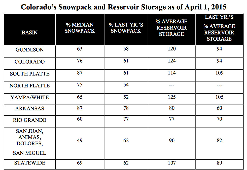
In Colorado Springs and across the Front Range, we are heavily reliant on the Colorado River for our water supply. The Colorado River starts in Colorado, but we only keep a portion of the flow for use in the state per the Colorado River Compact. The Colorado River also serves Arizona, Utah, Nevada, Wyoming, New Mexico and California (see below for a breakdown). There is also an obligation to Mexico. When any of the states or Mexico are in an extreme drought, their reliance on the Colorado River water may increase, possibly resulting in ripple effects that could negatively impact us. At any given time, the Colorado River supplies about 70 percent of our community’s water. Drought can also affect the levels in Lake Powell and Lake Mead, which part of the western United States relies on for power production.

Will Colorado Springs experience any impact from the situation in California?

The California drought will not have direct impacts to our community’s water supply yet. We are working closely with the Upper Basin States to create a proactive contingency plan in the event that storage levels in Lake Mead and Lake Powell drop to critical levels.

What is Colorado Springs Utilities doing to help protect our community from this type of situation?

Maintaining a dependable water supply for Colorado Springs residents and businesses is one of our community’s greatest challenges. Continuous long-term water planning is the reason we have a reliable water system today that supports our economy and quality of life. For us, planning is part of our daily responsibilities and includes factors such as water sources, demand, water rights, infrastructure, storage and much more. In addition, we are currently updating our Integrated Water Resource Plan, which provides the roadmap for sustainably addressing water supply and demand issues, while reflecting our community values.

What can customers do to help?

The intelligent use of water will always be a priority for our community, which has done a great job of adapting to our semi-arid climate. Our customers continue to find ways to use water wisely and we can help. A good place to start is our website, which has free xeriscape class schedules, efficiency ideas, DIY videos, and more. Folks should also join in the conversations we’re having through the Integrated Water Resource Plan process. There are opportunities for input, whether online or at upcoming meetings.

More Colorado Springs Utilities coverage here.

The April 1 Water Supply Outlook Report is hot off the presses from the NRCS, read it and weep

watersupplyoutlook0401205vianrcsstreamflow

watersupplyoutlook0401205vianrcssnowpackbybasin

Click here to read the report.

Aspinall Unit operations update

Crystal dam spilling May 2009

From email from Reclamation (Erik Knight):

Releases from Crystal Dam will be increased from 600 cfs to 750 cfs on Wednesday, April 8th at 8:00 AM. This release increase is in response to an increase in diversion to the Gunnison Tunnel. The current forecast for April-July unregulated inflow to Blue Mesa Reservoir is 480,000 acre-feet which is 71% of average.

Flows in the lower Gunnison River are currently above the baseflow target of 1050 cfs. River flows are expected to stay above the baseflow target for the foreseeable future.

Pursuant to the Aspinall Unit Operations Record of Decision (ROD), the baseflow target in the lower Gunnison River, as measured at the Whitewater gage, is 1050 cfs for April.

Currently, diversions into the Gunnison Tunnel are 300 cfs and flows in the Gunnison River through the Black Canyon are around 300 cfs. After this release change Gunnison Tunnel diversions will be around 400 cfs and flows in the Gunnison River through the Black Canyon should be around 350 cfs. Current flow information is obtained from provisional data that may undergo revision subsequent to review.

More Aspinall Unit coverage here.

Road to Jamestown open to all travelers for first time since 2013 flood — The Denver Post

Water Values podcast: Krausz USA President Tom Gwynn on US water infrastructure,

The latest Eagle River Watershed Council newsletter “The Current” is hot off the presses

eagleriver
Click here to read the newsletter. Here’s an excerpt:

Here in Colorado, we tend to think of precipitation in discrete, measured amounts: Inches of snow, cubic feet per second, acre feet of water. In an arid region often afflicted by drought, this is an understandable way to perceive our water situation. But if we dig deeper, the issues we face surrounding water are much more nuanced than simple measurements. Two other factors related to precipitation, the timing and type, are just as important as the amount, if not more so.

As any boater or skier will tell you, a storm bearing an inch of rain in July is very different from a system dropping an inch of rain in January. Though they may produce the same amount of precipitation, all storms are not created equally. Rain and snow are both welcome forms of precipitation and serve their own purposes, but the effects and consequences of each are quite different.

It is a classic case of “the tortoise and the hare.” Rain, the hare, moves quickly through watersheds, rapidly passing from cloud to ground to waterway and beyond. On the other hand, snow (the tortoise) stockpiles water in winter, gradually releasing it into waterways through spring runoff. Rain has more immediate benefits to and effects on the system, while the impacts of snow are on a time delay. I think we all remember who wins the metaphorical race.

For our rivers and streams and for our recreation-based economy, it is imperative that the majority of our annual precipitation (approximately 80 percent) comes in the form of snow. For a few important reasons, rain just won’t cut it.

NIDIS: Weekly Climate, Water and Drought Assessment for Colorado and the Upper #ColoradoRiver Region

Upper Colorado River Basin April 2015 precipitation as a percent of normal via the Colorado Climate Center

Click here to read the current assessment. Click here to go to the NIDIS website hosted by the Colorado Climate Center.

More Colorado River Basin coverage here.

The April 1 USDA – Natural Resources Conservation Service news release is hot off the presses

snowpackreservoirstorage04012015nrcs

Here’s the release from the Natural Resources Conservation Service (Brian Domonkos):

Significant snowpack gains in late February and early March were a result of a short-lived weather pattern lasting only until March 6th. Afterward, the proverbial faucet shut off yielding minimal precipitation through the remainder of March. The period of March 6th through April 1st 2015 was the second driest for the period of record dating back to 1986, only 2012 saw a drier March 6th through April 1st period.

To compound the issue, early spring temperatures this year have caused snowpack melt, observed most particularly at lower and some mid-elevation SNOTEL sites. Seasonal snowpack decline this early in the spring is rare and only occurs in one out of every ten years. Water year 2012 was the extreme case in which snowpack began melt and continued unabated for the remainder of the spring due to above normal temperatures.

“While late season snowstorms large enough to provide the kind of moisture we need in the mountains of Colorado are possible, they are not probable at this point.” said Brian Domonkos, hydrologist with the NRCS Colorado Snow Survey Program. Domonkos went on to say, “Coloradans and other downstream water users should be prepared for below average streamflows this spring and summer provided near or below average precipitation.”

Currently statewide snowpack is 69 percent of normal, down from 87 percent last month according to SNOTEL and snow course observation sites. This ranks Colorado mountain snowpack third from the minimum year in 2002 out of a 30 year period of record. The persistent bright spot in the state is in the South Platte River basin where snowpack was 110 percent of normal last month. While the South Platte did experience a large decline in percent of normal snowpack during March, it remains tied for the best snowpack in the state as of April 1 at 87 percent of normal, along with the Arkansas.

April 9 is typically the time of year when Colorado mountain snowpack is peaking or experiencing it highest values of the winter season. If the warm temperatures and below normal precipitation continues, that peak this year will have occurred closer to March 9.

Some watersheds have considerable reservoir storage, but this will likely not be enough to offset the snowpack deficits. Reservoir storage remains better in the northern half of the state while the southern half remains below normal. “March is the second most significant month for mountain precipitation in Colorado. April is the most important, so if this dry trend continues through April, it would be a real one-two punch to Colorado’s water supply.” suggests Domonkos.

Snowpack/runoff news: The San Miguel, Dolores, Animas, and San Juan watersheds turn red (<50% of normal)

Click on a thumbnail graphic to view a gallery of snowpack data from the Natural Resources Conservation Service.

From Rocky Mountain PBS INews (Jim Trotter):

The so-called Snotel readings, which measure the moisture content of snowpack, are a product of the Natural Resources Conservation Service in the U.S. Department of Agriculture. They started in the late 1970s, and now have 885 reading sites Westwide. The percent of average is based on the last 30 years.

In Colorado, the lowest readings are in the southwest quadrant of the state, at 54 percent of average. The highest reading is at 88 percent of average on the South Platte basin side of the northern and central Rockies.

Particularly along the ranges in the Pacific Coast states, the readings are disastrous, of course, for summer water supplies to both urban areas and agriculture, and set up the potential for another brutal fire season.

And it’s not inappropriate for us to feel a little apprehension, as we wait for what April will bring.

From The Aspen Times (Scott Condon):

Colorado’s overall snowpack is the third worst in 30 years for this time in April, according to the Natural Resources Conservation Service.

The snowpack is down to 69 percent of normal. It fell from 87 percent of normal one month ago, the federal agency said.

In addition to the dry conditions, spring temperatures are higher than normal, so the snowpack is disappearing earlier than usual, according to the conservation service…

The snowpack disappeared rapidly throughout the Roaring Fork River basin after a series of storms dumped about six feet of snowfall on slopes in two weeks during late February and early March. The snowpack in the headwaters of the Roaring Fork River is 89 percent of average. In the Fryingpan Valley, the snowpack completely melted at Nast Lake, which is at 8,700 feet in elevation, according to the conservation service. The snowpack is still at 93 percent at Ivanhoe Reservoir, which is at 10,400 feet in elevation.

The snowpack is only 64 percent of normal at Schofield Pass at the headwaters of the Crystal River. It’s at 44 percent at the North Lost Trail snowpack measurement site near Marble.

March came in like a lion but ended like a lamb for Aspen Skiing Co. ski areas. Snowmass received 54 inches of snow during the month, about 90 percent of average, according to company spokesman Jeff Hanle. Aspen Mountain received 41 inches or 77 percent. Aspen Highlands received 44 inches or 80 percent. Buttermilk collected 25 inches or 50 percent of average, Hanle said.

From CBS Denver:

“We’re the headwater state to 18 downstream states and the country of Mexico, so when we do anything on water issues everybody notices,” James Eklund with the Colorado Water Conservation Board said.

Colorado snowpack is currently only 65 percent of average, but where that water is heading is a different story.

Right now the Colorado reservoirs are 108 percent of average.

“We’re actually better this year storage-wise than we were last year,” Eklund said.

“We need to really be cautious, we live in a dry state, you never know what the next year or even the summer will bring, so it’s just smart to use water efficiently,” Stacy Chesney with Denver Water said.

Denver Water services nearly 25 percent of the state’s population, but only uses 2 percent of the water. This year its resources are in the wettest parts of the state.

“Denver Water supply is actually in pretty good shape at this point, and that’s thanks to normal snowpack in our collection area, as well as reservoir levels that are higher than average, and really efficient water use by our customers,” Chesney said.

“If California has another year like they have this year, then we need to have that plan stood up and ready to go,” Eklund said. “So time is of the essence.”

State officials say they’re learning quite a bit from California. The state is in the works of finalizing the Colorado water plan so in case of a dangerously dry year water officials will know what to do.