
Here’s the release from the Natural Resources Conservation Service (Brian Domonkos):
Significant snowpack gains in late February and early March were a result of a short-lived weather pattern lasting only until March 6th. Afterward, the proverbial faucet shut off yielding minimal precipitation through the remainder of March. The period of March 6th through April 1st 2015 was the second driest for the period of record dating back to 1986, only 2012 saw a drier March 6th through April 1st period.
To compound the issue, early spring temperatures this year have caused snowpack melt, observed most particularly at lower and some mid-elevation SNOTEL sites. Seasonal snowpack decline this early in the spring is rare and only occurs in one out of every ten years. Water year 2012 was the extreme case in which snowpack began melt and continued unabated for the remainder of the spring due to above normal temperatures.
“While late season snowstorms large enough to provide the kind of moisture we need in the mountains of Colorado are possible, they are not probable at this point.” said Brian Domonkos, hydrologist with the NRCS Colorado Snow Survey Program. Domonkos went on to say, “Coloradans and other downstream water users should be prepared for below average streamflows this spring and summer provided near or below average precipitation.”
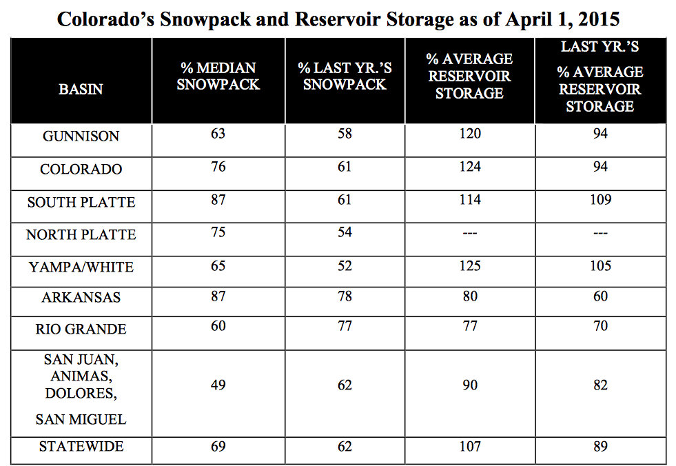
Currently statewide snowpack is 69 percent of normal, down from 87 percent last month according to SNOTEL and snow course observation sites. This ranks Colorado mountain snowpack third from the minimum year in 2002 out of a 30 year period of record. The persistent bright spot in the state is in the South Platte River basin where snowpack was 110 percent of normal last month. While the South Platte did experience a large decline in percent of normal snowpack during March, it remains tied for the best snowpack in the state as of April 1 at 87 percent of normal, along with the Arkansas.
April 9 is typically the time of year when Colorado mountain snowpack is peaking or experiencing it highest values of the winter season. If the warm temperatures and below normal precipitation continues, that peak this year will have occurred closer to March 9.
Some watersheds have considerable reservoir storage, but this will likely not be enough to offset the snowpack deficits. Reservoir storage remains better in the northern half of the state while the southern half remains below normal. “March is the second most significant month for mountain precipitation in Colorado. April is the most important, so if this dry trend continues through April, it would be a real one-two punch to Colorado’s water supply.” suggests Domonkos.