Denver waterways Weir Gulch, Harvard Gulch S. Platte R. get attention — The Denver Post

Michael Bouchard (Denver Parks and Recreation) with details about planned recreational development along the river through Denver

From The Denver Post (Joe Vaccarelli):

The U.S. Army Corps of Engineers, the city of Denver and other local agencies will be spending the next few years exploring ways to improve the South Platte River, Harvard Gulch and Weir Gulch as part of a comprehensive plan for the waterways.

The Urban Waterways Restoration Study will look into improving the ecosystem, reduce flood risk and adding recreational opportunities at all three sites. The South Platte will be studied between Sixth and 58th avenues.

“It’s a huge coordinated effort,” said Selena Klosowski, project manager for the Urban Waterways Restoration Study with Denver Public Works.

Weir Gulch runs into the South Platte River and generally ranges from 10th Avenue to Jewell Avenue and west to Alameda Parkway. The Harvard Gulch watershed is bounded by the South Platte to the west, Interstate 25 to the east and Evans Avenue to Mansfield Avenue.

Other local entities involved with the study include the Colorado Water Conservation Board and the Urban Drainage and Flood Control District.

Residents will have an opportunity to learn more about the study and give feedback at three upcoming meetings. Three more meetings are coming in the fall, and another one in the spring of 2016. All meetings will have translators present for non-English speakers. The study should be complete by spring or early summer 2017.

More restoration/reclamation coverage here.

Circle of Blue: Our @waltonwater annual pricing survey of 30 US cities is out

#Drought news (Part 2): Last week’s storminess helps the South Platte Basin drought picture (drought free)

Click here to go to the US Drought Monitor website. Here’s an excerpt:

Summary

During the past 7-days, moderate to heavy rain (generally 0.5-3.0 inches, locally greater) fell across portions of the Southeast, the Gulf Coast, the Great Plains, and the Ohio Valley. These areas of precipitation occurred in proximity to several slow-moving/stationary fronts and mid-level troughs. By far the heaviest precipitation totals were observed near the Gulf Coast, where numerous coastal counties from southeastern Texas to the extreme western Florida Panhandle received 5-10 inches during the past week. Precipitation amounts were generally light (0.5-inch or less) in the interior Pacific Northwest, the Southwest and the northern Plains…

The Plains

In North Dakota, light rain fell during the past 7-days, offsetting further deterioration of conditions. Temperatures also fell significantly (below freezing in some areas), keeping evaporation rates low. In South Dakota, only slight adjustments were made to the drought depiction. In north-central South Dakota, moderate drought (D1) was extended slightly northward into Walworth and Edmunds Counties. In southeastern South Dakota, moderate drought (D1) was expanded slightly southward to include eastern Hutchinson, central Turner, and northern Lincoln Counties. Most other areas of the state received enough rain this past week (a quarter-inch to an inch) to offset additional deterioration of conditions, but not enough to justify improvements. In the southern portion of the Nebraska Panhandle and nearby southeastern Wyoming, abnormal dryness (D0) was eliminated due to a recent storm system that produced about 2 inches of precipitation (liquid equivalent), much of which fell as wet snow. The region is finally beginning to experience spring green-up. The improved conditions also warranted the removal of abnormal dryness (D0) in the northern Laramie Range in southeastern Wyoming. During the past week in the Sand hills region of north-central Nebraska, 2-4 inch rainfall surpluses and good soil moisture infiltration prompted a 1-category improvement to the depiction. In northeastern Nebraska, despite receiving decent moisture over the past 2 weeks, significant deficits still linger at the 30-, 60-, and 90-day time periods. Therefore, the depiction remains unchanged in this area, pending reassessment next week. In Kansas, respectable rains (mostly 0.5-2.0 inches, locally greater) helped to offset any additional degradation. Surface water supplies are still low, and runoff is minimal. No alteration was made to the Kansas drought depiction this week.

The southern Great Plains also experienced a mix of both improvements and degradations. In Oklahoma, 1-category degradations were made in the western Panhandle, as only 1.0-1.5 inches of rain fell during the past 30-days. There were reports of dust storms and dead dryland wheat across much of this area. In west-central Oklahoma, a swath of 4-8 inch rains prompted a 1-category improvement from about Roger Mills County northeastward to Major County. In extreme northeastern and northwestern Roger Mills County, and most of adjacent Ellis County, no good runoff rains were reported, suggesting status quo for those areas. In Texas, widespread 1-category improvements were made to the drought depiction after recent rain fell over many areas that needed it. Stream flows are improving in southern and south-central Texas, and there is continued reservoir improvement in the Dallas area. In the Panhandle region, some of the wheat crop is expected to be salvaged, but it is unlikely the crop will return to normal…

The West

Moderate precipitation (0.5-2.0 inches, liquid equivalent) fell in much of the Upper Colorado River Basin this past week, though not enough to greatly improve snowpack or stream flows. This region will be monitored for possible improvements next week. In parts of northeastern Colorado, where 1-3 inches of rain have fallen so far this April, 1-category upgrades were made. This includes Cheyenne County in extreme eastern Colorado, and near the northern border with Wyoming. In southern New Mexico, moderate drought (D1) was removed from southwestern Chavez and all of Otero Counties due to good moisture conditions. The Pecos River Valley is doing well on the eastern side of the state, with full reservoirs and commencement of irrigation. Conditions are not as promising though for the Rio Grande Valley.

In northeastern California, exceptional drought (D4) was expanded across the northern Sierras this week, while in northern Modoc County, a one-category improvement (from D4 to D3) was rendered to the depiction to more accurately reflect local conditions. In east-central California near Yosemite National Park, the average surface elevation of Mono Lake stood at 6378.9 feet, as of April 15th. This is the lowest surface elevation of the lake since early 1996. The target elevation is 6391 feet. For the past two weeks, extreme to exceptional drought (D3-D4) covered two-thirds of California. In northern Nevada, a one-category degradation was made to northwestern Elko County, while in southwestern Montana, small improvements were made to the drought depiction in Gallatin County.

In Washington state, record/near-record low snowpack supports the expansion of moderate drought (D1) across the northern Cascades, and the introduction of moderate drought in northeastern Washington…

Looking Ahead

For the ensuing 5-day period, April 23-27, northern New England, portions of Georgia and Alabama, and southern Florida are expected to receive 1.0-1.5 inches of precipitation, which would help in the mitigation of existing dryness/drought. Up to about 2 inches of rain is forecast for the easternmost portions of the drought region in both Oklahoma and Texas, during this period. Light precipitation (0.25-inch or less) is anticipated for most of the Dakotas and upper Mississippi Valley, though western South Dakota is expected to receive 1.0-1.5 inches of rain. Between 1.0-1.5 inches of precipitation (liquid equivalent) is predicted for parts of the West.

For the 6-10 day period, April 28-May 2, there are enhanced odds of near- to below-median precipitation across most of the contiguous U.S. Odds favor above-median rainfall from the central and eastern Gulf Coast region northeastward across the Southeast, mid-Atlantic, and southeastern New England.

Snowpack news: “Snowpack still low in Colorado; Lake Powell inflows below average” — Hannah Holm #ColoradoRiver

From the Grand Junction Free Press (Hannah Holm):

Last week’s storms, which snarled Interstate 70 and (briefly) turned Grand Valley trails to sticky mud, calmed fears of an early start to wildfire season; but it didn’t significantly improve the regional water supply picture.

April 20 snowpack levels in western Colorado ranged from 40 percent of average in the Southwestern basins to 71 percent in the Colorado Basin. The statewide snowpack was at 61 percent of average. The South Platte Basin snowpack, upstream from Colorado’s most populated areas, got the biggest bump out of the storms and reached 94 percent of average. Statewide, the total amount of water in the snow that has fallen since the 2015 water year began on October 1, 2014 (as opposed to snowpack at this moment in time) was a little less than 80 percent of normal.

As mediocre as Colorado’s snowpack is, it’s in better shape than the snowpack in most of the rest of the West. Eastern Utah is down to just four percent of normal, with no basin in the state above 50 percent.

Unsurprisingly, forecast inflows into Lake Powell are significantly below average. The Bureau of Reclamation forecast released April 20 predicted inflows of just 6.832 million acre feet, or 63 percent of normal, for the full 2015 water year.

At the same time, the total forecast releases from Lake Powell to Lake Mead, under operating criteria agreed to several years ago by the states that share the river, are expected to be between 8.23 and 9.0 million acre feet.

So Lake Powell, which is currently 45-percent full, will certainly not be getting any fuller this year. Lake Mead is 39-percent full, and total Colorado River Basin storage is 48-percent full, up one percentage point from last year. [ed. emphasis mine]

The U.S. Drought Monitor predicts that the next three months are likely to be wetter than average for the four-corners states, and that the relatively mild drought (compared to California) over most of Western Colorado is likely to improve. Farther to the South and West, however, drought conditions are expected to persist or intensify.

This year, due to good storage levels, we probably won’t see severe water shortages in Colorado; and downstream, Lake Mead is likely to get just enough water to prevent a formal shortage declaration, which would lead to reduced water deliveries to some Arizona farmers.

But the troubling long-term picture in the Colorado River Basin as a whole is not improving, and another year like this one will lead to those formal shortage declarations in the Lower Basin, as well as drop Lake Powell closer to the minimum level at which it can generate power.

This regional context is important to keep in mind as Colorado’s water leaders continue their work to complete a statewide water plan. The East Slope as well as the West Slope relies heavily on water from the Colorado River Basin, and both current and future uses of this water could be impacted if water storage levels drop much lower.

This is part of a series of articles coordinated by the Water Center at Colorado Mesa University in cooperation with the Colorado and Gunnison Basin Roundtables to raise awareness about water needs, uses and policies in our region. To learn more about the basin roundtables and statewide water planning, and to let the roundtables know what you think, go to http://www.coloradomesa.edu/WaterCenter. You can also find the Water Center on Facebook at http://Facebook.com/WaterCenter.CMU or Twitter at http://Twitter.com/WaterCenterCMU.

#Drought news: “Blob of warm Pacific water threatens ecosystem, may intensify drought” — CNN

From CNN (Steve Almasy, Dave Hennen and Jennifer Gray):

A University of Washington climate scientist and his associates have been studying the blob — a huge area of unusually warm water in the Pacific — for months.

“In the fall of 2013 and early 2014 we started to notice a big, almost circular mass of water that just didn’t cool off as much as it usually did, so by spring of 2014 it was warmer than we had ever seen it for that time of year,” said Nick Bond, who works at the Joint Institute for the Study of the Atmosphere and Ocean in Seattle, Washington.

Bond, who gave the blob its name, said it was 1,000 miles long, 1,000 miles wide and 100 yards deep in 2014 — and it has grown this year.

And it’s not the only one; there are two others that emerged in 2014, Nate Mantua of the Southwest Fisheries Science Center — part of the National Oceanic and Atmospheric Administration (NOAA) — said in September. One is in the Bering Sea and the other is off the coast of Southern California.

Waters in the blob have been warmer by about 5.5 degrees, a significant rise.

Persistent pressure

A recent set of studies published in Geophysical Research Letters by Bond’s group points to a high-pressure ridge over the West Coast that has calmed ocean waters for two winters. The result was more heat staying in the water because storms didn’t kick up and help cool the surface water.

“The warmer temperatures we see now aren’t due to more heating, but less winter cooling,” a recent news release from the University of Washington announcing the studies said. The university has worked with NOAA on the research.

According to New Scientist magazine, some marine species are exploring the warmer waters, leading some fish to migrate hundreds of miles from their normal habitats.

The magazine cited fisherman and wildlife officials in Alaska who have seen skipjack tuna and thresher sharks.

Pygmy killer whales have been spotted off the coast of Washington.

“I’ve never seen some of these species here before,” Bill Peterson of the Northwest Fisheries Science Center in Seattle told the New Scientist.

And he was worried about the adult Pacific salmon that normally feed on tiny crustaceans and other food sources that are not around in the same numbers off the coast of the Pacific Northwest.

“They had nothing to eat,” he told the magazine of last year’s conditions in the blob. It appears that food has moved to cooler waters.

In January, Bond told the Chinook Observer in Long Beach, Washington, that his concern is for very young salmon that are still upstream.

“In particular, the year class that would be going to sea next spring,” he said.

NOAA said in a news release last month that California sea lion pups have been found extremely underweight and dying, possibly because of an ocean with fewer things to eat.

“We have been seeing emaciated or dehydrated sea lions show up on beaches,” Justin Greenman, assistant stranding coordinator for NOAA on the West Coast, told CNN.

The numbers are overwhelming facilities that care for the stranded sea lions, most of whom are pups, local officials said.

Record number of sea lion pups stranded in California

Warmer water, less snow

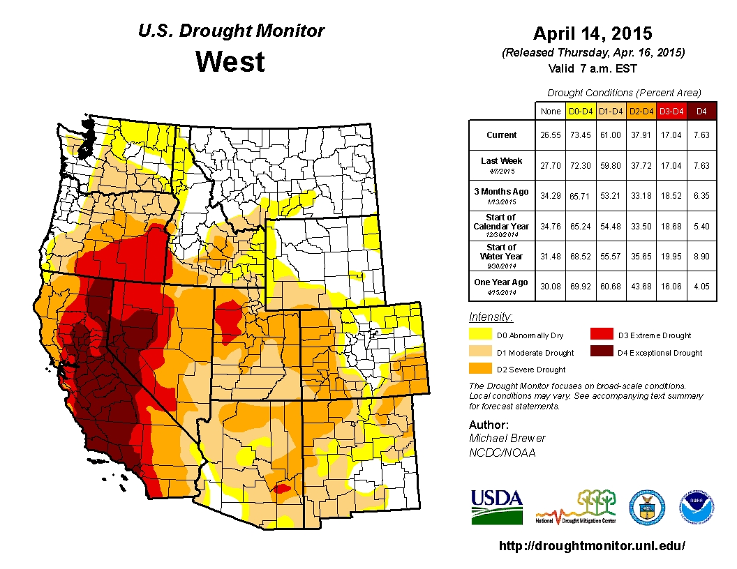
The blob also is affecting life on land. For the past few years, that persistent ridge of high pressure has kept the West dry and warm, exacerbating the drought in California, Oregon and Washington.

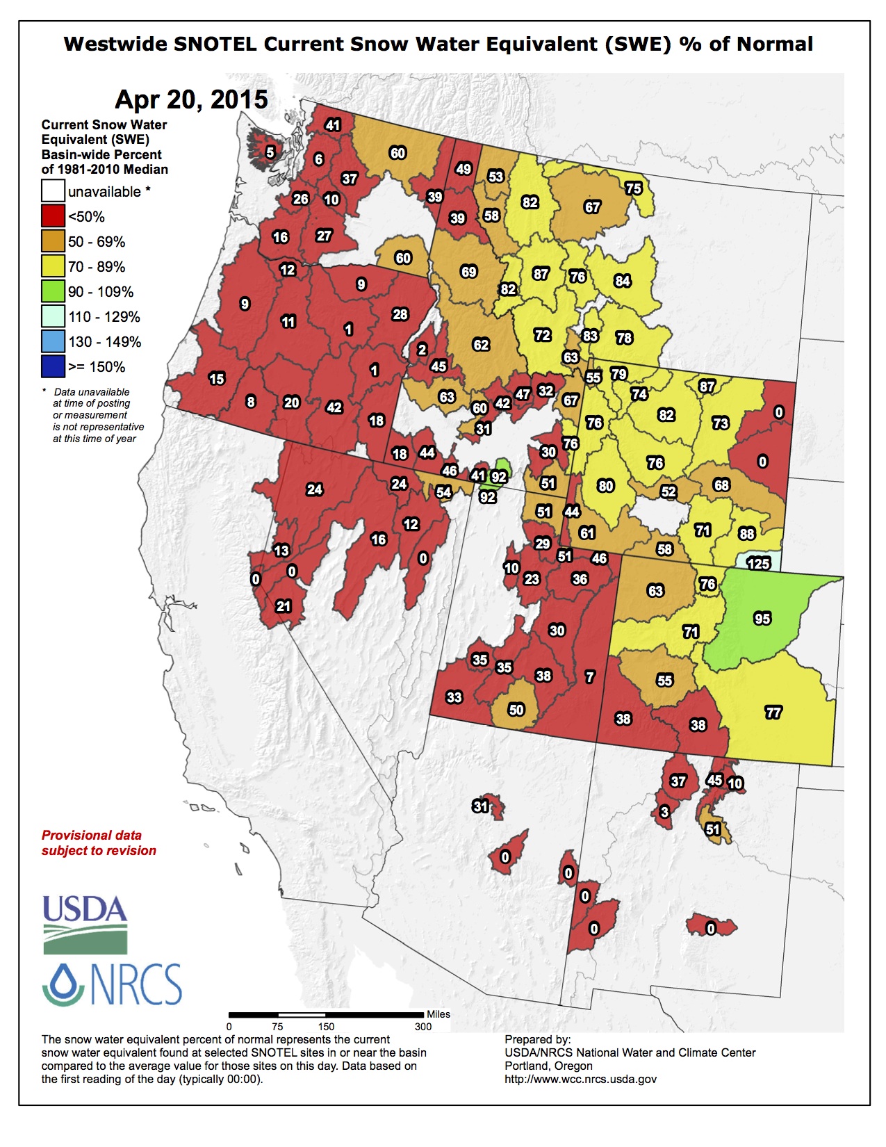
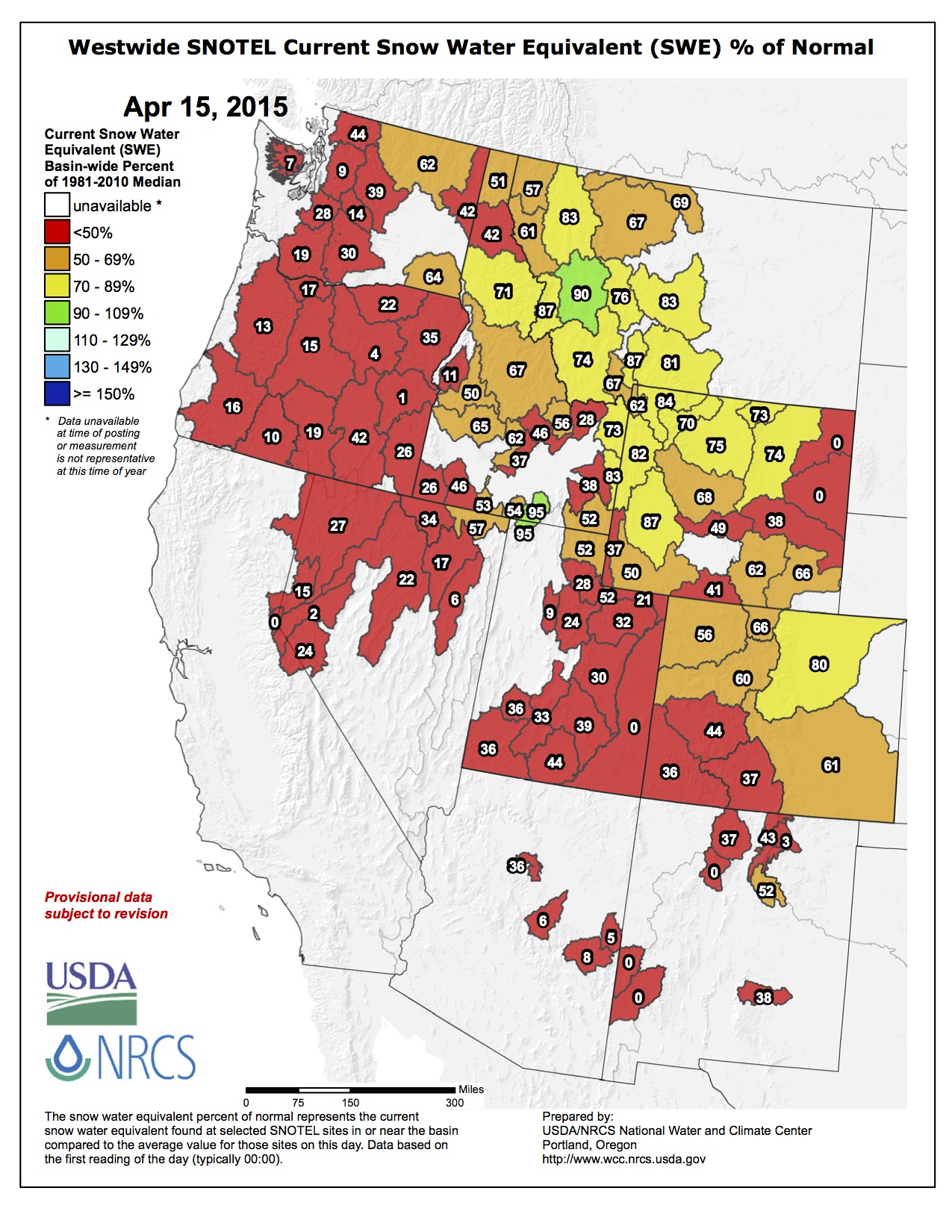
One of the primary problems is small snow accumulation in the mountains.

In early April, officials measured the snowpack in California at a time when it should be the highest. This year it hit an all-time low at 1.4 inches of water content in the snow, just 5% of the annual average. The previous low for April 1 had been 25% in 1977 and 2014. (pdf)

Gov. Jerry Brown, in announcing water restrictions the same day, stood on a patch of dry, brown grass in the Sierra Nevada mountains that is usually blanketed by up to 5 feet of snow.

Low California snowpack ushers mandatory water restrictions

The heat has caused rising air, which can lead to conditions that produce more thunderstorms. With warmer air in California, areas at higher elevations that usually see snow have seen rain instead. That has led to the lower snowpack and helped compound the drought. The storms also mean more lightning and more wildfires.

And the blob affects people on other areas of the country.

That same persistent jet stream pattern has allowed cold air to spill into much of the Midwest and East.

This stuck pattern has led to the record cold and snow in the Midwest and Northeast over the last two seasons with record snows we have seen in Boston and Detroit, and the most snow we have seen in decades for cities such as Chicago.

Still a mystery

The weather pattern is confusing the experts.

There are some that think it might be a Pacific Decadal Oscillation, a long-lasting El Nino-like pattern in the Pacific.

Dennis Hartmann, a professor of atmospheric science at the University of Washington, doesn’t believe the answer is clear.

“I don’t think we know …” he said in the university’s news release. “Maybe it will go away quickly and we won’t talk about it anymore, but if it persists for a third year, then we’ll know something really unusual is going on.”

From The Produce News (Kathleen Thomas Gaspar):

With an ongoing drought a major factor in the San Luis Valley’s potato industry, planting this coming season could be down between 8 and 10 percent from last year’s 55,000 acres.

Jim Ehrlich, executive director of the Colorado Potato Administrative Committee based on Monte Vista, told The Produce News in mid-April he had “no way of knowing” going into planting, but he said given circumstances he looks for it to be down.

“It could be between 50,000 and 52,000 acres, but right now we just don’t know,” Ehrlich said. Acreage in 2014 was bumped up from the previous year’s 49,700 acres, and Colorado’s largest potato production area saw an overall better growing season. Summer hail hit just under 4,000 acres, but nonetheless shipments year-to-date for March 2015 were up from the previous year.

Arkansas River Basin Water Forum recap: “We like our chances better with a strategy” — James Eklund #COWaterPlan

Colorado Water Plan website screen shot November 1, 2013

From The Pueblo Chieftain (Chris Woodka):

A state water plan may not prevent a crisis, but it would give the state a way to better deal with it.

“We like our chances better with a strategy,” said James Eklund, executive director of the Colorado Water Conservation Board. “We’ve got a path forward.”

Eklund addressed about 150 people who attended the opening day of the Arkansas River Basin Water Forum at Pueblo Community College.

The state will spend most of this year putting the finishing touches on a water plan to be presented to Gov. John Hickenlooper on Dec. 10. Eklund has spent the last 20 months talking to water groups throughout the state about what the plan does and how it will be used. Most recently, the state’s basin roundtables wrapped up basin implementation plans that feed into the final document.

Actually, it won’t be “final.”

Eklund called it “opensource policymaking,” meaning anyone with a smartphone or computer can logon (http://coloradowaterplan.com) and comment at any time.

California and Texas voters approved bond issues for $7.5 billion and $2 billion by 2-1 margins, largely because they had water plans in place, Eklund said.

“We’ve got to determine water priorities more aggressively than in the past,” he said. “The state will not pick winners or losers, but will be able to prioritize regional projects, like we do now for transportation.”

The plan also will connect state policies on water, ending current trends that put water quality in one “silo” (Colorado Department of Public Health and Environment) and quantity in another (Division of Water Resources).

“The Arkansas basin is a poster child for how you do this work,” Eklund said. “We need you to comment and help on the plan. We need to make sure our house is in order and that we’re unified as a state.”

The plan has to be flexible enough to meet the needs of a state that is expected to see its population double in 50 years. During his presentations, Eklund likes to show a picture of his own dour-faced great-greatgrandparents, whom he jokes would want no part of a water plan.

But times change.

“We’re living with the water policies our grandparents gave us, but we’re designing policies for our grandchildren,” Eklund said. “When people go home to be with their kids, they have to realize it’s not something you can take for granted. You have to plan for it.”

More Colorado Water Plan coverage here.

Rio Grande National Forest federal reserved water right decree a “huge success story” — The Pueblo Chieftain

riograndebasin

From The Pueblo Chieftain (Matt Hildner):

Few things heighten the blood pressure of water users like a federal reserved water right.

Around the American West they’ve been used to secure water supplies for Indian reservations, national parks and other federal lands, occasionally overturning the pecking order defined in water law by the maxim “first in time, first in right.”

But local water users in the San Luis Valley have spent the last couple of months urging the Rio Grande National Forest to protect one that’s believed to be the only one of its kind ever granted to an entire national forest.

“It’s a huge success story, not only for the federal agency, but for the water users in the San Luis Valley,” said Travis Smith, who represents the region on the Colorado Water Conservation Board.

Local groups and forest officials spent more than two decades negotiating the decree that protects in-stream flows on the 1.9 million-acre national forest before hammering out an agreement in 2000.

The decree established 303 quantification points on the headwaters of streams and rivers in the eastern San Juan and La Garita mountains and the northern Sangre de Cristos.

Each quantification point includes minimum high flows and maximum high flows that vary depending on the time of year.

The in-stream flows, which don’t involve the removal or consumption of any water, are designed to protect stream function and fish habitat.

The decree also gave forest officials the right to an unspecified amount for fighting fires.

But the upcoming revision of the forest’s management plan has prompted the federal agency to examine its existing management practices — including those for water — and collect public opinion on whether change is needed.

The plan-revision process is expected to last four years, but U.S. Forest Service officials want the feedback before they begin devising management alternatives later this year.

Toward that end, the Rio Grande Basin Roundtable, a 21-member panel representing users from around the valley, voted earlier this month to submit comments calling for the decree to stay the same.

The Rio Grande Water Conservation District followed with a similar vote Tuesday.

Such consensus would have seemed unlikely in the 1970s when the Forest Service began seeking federal reserved rights for in-stream flows at water courts around the state.

The trials for those efforts in the South Platte and Arkansas river basins were sprawling affairs with each ending up in the Colorado Supreme Court before being sent back to their respective trial courts.

Neither water court, in the end, granted in-stream-flow rights to the national forests in those basins.

And, initially, there was plenty of opposition in the Rio Grande Basin as 35 parties filed objections to the Forest Service’s filing.

Steve Vandiver is director of the Rio Grande Water Conservation District but he was involved in negotiations for the Rio Grande’s decree as the division engineer at the time.

He said the lack of development in the headwaters of the Rio Grande compared to other river basins made it much easier to reach a deal.

“If you look at the other basins, there’s a lot of private ground in and above the forest,” he said. “If you’re Vail, or you’re Aspen or Copper Mountain, you don’t want a dedicated flow below you that has to be met every day.”

The decree signed by Judge Robert Ogburn mirrors Vandiver’s point, noting that there are only four large reservoirs and 181 other water rights located on or upstream of Forest Service lands.

Still, local water organizations secured important concessions in the decree.

The priority date for the forest’s water right was pegged at 1999, even though the lands covered by the decree were brought into the national forest between 1902 and 1938.

Another point in the agreement holds that if the Forest Service impeded on the exercise of other water rights or increased its stream flows through the use of its land-use authority, the decree could be reopened.

Jim Webb, who served as forest supervisor for the Rio Grande at the time of the decree, credited Vandiver and other local water leaders at the time for being forward thinking. “There was a high degree of trust,” he told The Chieftain in a phone interview.

Moreover, he said the failed efforts by American Water Development Inc. and Stockman’s Water Co. to take water out of the valley made water managers more amenable to locking down in-stream flows on the forest.

He, like Vandiver, wants the decree left untouched, adding that there’s no unclaimed water left on the forest to increase the in-stream flows or become available for downstream users.

He also doesn’t want to see anyone mess with the decree because of the impact it would have on the forest’s relationships with its neighbors in the valley.

“Politically, it would be a bomb,” he said.

More Rio Grande River Basin coverage here.

Happy Earth Day!

bootprintearth

Weekly Climate, Water and Drought Assessment of the Upper #ColoradoRiver Basin

Upper Colorado River Basin precipitation April 1 thru April 19, 2015 via the Colorado Climate Center

Click here to read the current assessment. Click here to go to the NIDIS website hosted by the Colorado Climate Center.

Snowpack news: Recent storm delights late-season powder-hounds

From the Examiner:

A cut-off low pressure storm returned the Rocky Mountains to winter this past week. Skiers and snowboarders flocked to the the ski areas that were still open and to their local backcountry slopes to enjoy the ridiculous amounts of snow that fell. Snowbird, Utah reported 42 inches from April 15 to 16 while the resorts of Loveland, Arapahoe Basin, and Winter Park received 32, 25, and 20 inches respectively…

Colorado’s snowpack not only contributes water for municipal, industrial, and agricultural uses but supports millions of dollars in tourism with non-consumptive uses like whitewater rafting, fly-fishing, and more. The state hosted around 500,000 rafters last year but likely won’t meet those numbers again this year. The smaller snowpack this year will reduce flows in the river, and how long the rivers are are able to be rafted. However, many reservoirs statewide are near capacity, which will help dam-released rivers keep their flows throughout the summer.

Before this storm, the Colorado snowpack was at 65% of average. While this storm dropped incredible amounts of snow, it did not make a huge impact on the state of Colorado’s snowpack. The snowpack still sits around 65% of average but is being dragged down by an incredibly dry winter in the southern portion of the state. The Upper Rio Grande Basin is currently sitting at 38% of average while the San Miguel, Dolores, Animas, and San Juan Basin is sitting at 41% of average. This is in comparison to the South Platte River Basin, which is sitting at 95% of average. The snowpack current report can be viewed here. Many industries vital to Colorado, and the West’s, identity and economic survival are dependent upon the winter precipitation their mountains receive. While this storm has bolstered the meager snowpack, it will only serve as a bandage on the severed artery that is the West’s water woes.

From The Mountain Mail (Marcus Hill):

In Colorado April often brings snow rather than rain showers, and Mother Nature dealt Salida a heavy dose of it Thursday and Friday, causing power outages, cancellations and other problems.

The snow caused the city to eclipse its average precipitation for the month in just 2 days. April’s average is 1.18 inches. The storm last week resulted in 1.24 inches of precipitation.

Snow began falling Thursday evening, with large flakes wetting the streets but failing to stick. As the night waned, the streets froze and snow began to stick. The snow continued through Friday morning, accumulating up to 2 feet in some areas.

From the Glenwood Springs Post Independent:

The snowstorm last weekend didn’t boost the snowpack in the Roaring Fork River basin up to average, but it added some much-needed moisture to most areas monitored by the U.S. Natural Resources Conservation Service.

The snowpack at the headwaters of the Roaring Fork River east of Aspen didn’t change much despite the pounding at Aspen Mountain, according to the conservation service’s Snotel weather measuring station near Grizzly Reservoir. The snowpack was at 92 percent of the average established between 1981 and 2010 as of April 16 and remained that way Monday, after the storm moved on. There was the equivalent of 14.6 inches of water in the snowpack as of Monday. The average for the date is 15.7 inches.

It was a different story at the headwaters of the Fryingpan and Crystal Rivers. Up the Fryingpan, the Ivanhoe station increased from 92 percent of average snowpack on April 16 to 107 percent Monday. The snow-water equivalent is 14.2 inches.

The Kiln site in the Fryingpan Valley went from 25 percent of average snowpack before the storm to 43 percent after. The Nast site, which is at the lowest elevation of the three weather stations in the Fryingpan, went from no snowpack to 57 percent of average. It had a snow-water equivalent of 0.8 inches.

The snowpack picture in the Crystal River Valley went from bleak to only slightly better with the storm. The snowpack at Schofield Pass went from 61 percent of average to 64 percent. The snow-water equivalent at that high elevation weather station was 20.9 inches.

McClure Pass went from no snowpack to 13 percent of average. There is only 1.8 inches of snow-water equivalent at the site.

North Lost Trail outside of Marble was only slightly better. It went from 14 percent of average snowpack to 35 percent with a snow-water equivalent of 4.1 inches.

Rain and snow showers are in Aspen’s forecast for the next few days, but it’s going to be too little, too late to help the snowpack. In an average year, the snowpack builds until reaching a peak in early to mid-April. Dry conditions throughout the winter and warm temperatures through the spring ate up the snowpack early.

Southern Delivery System: Closing arguments expected to conclude today in Walker Ranch lawsuit

Southern Delivery System route map -- Graphic / Reclamation
Southern Delivery System route map — Graphic / Reclamation

From The Pueblo Chieftain (Chris Woodka):

Closing arguments are expected to wrap up sometime today in a jury trial to determine the value of the Southern Delivery System easement across Walker Ranches in Pueblo County.

Expert witnesses for Colorado Springs testified Tuesday, the seventh day of the trial.

Attorneys for both sides indicated the testimony would wrap up soon and they were preparing to present closing arguments today. After that, the jury will begin its deliberations.

Court records indicate Gary Walker was offered $100,000 for easements on a 150-foot wide strip 5.5 miles long through Walker Ranches in northern Pueblo County. Colorado Springs, which is building SDS, also paid Walker $720,000 to relocate cattle during three years of construction.

Construction on SDS began in 2011, and includes 50 miles of underground pipeline 66 inches in diameter in Pueblo and El Paso counties. The final phase of construction in Pueblo County is the Juniper Pump Station being built near Pueblo Dam.

Walker claims the choice of pipeline route has contributed to erosion and diminished the value of his land. His court records claim SDS has caused $25 million worth of impact on his ranches, which total 65,000 acres. He’s also claiming damages under Pueblo County’s 1041 permit for SDS, which protects landowners from out-of-pocket expenses and requires Colorado Springs to use eminent domain only as a last resort.

District Judge Jill Mattoon is presiding over the trial.

More Southern Delivery System coverage here.

2015 Colorado legislation: SB15-212 scheduled for hearing today in Senate Ag committee #coleg

Detention pond
Detention pond

From The Pueblo Chieftain (Chris Woodka):

A bill that would allow flood water to be stored regardless of the impact on water rights would not affect a proposal to build flood control structures on Fountain Creek.

The district is looking at building a dam or several detention ponds on Fountain Creek. It has no interest in getting blanket authority under [Senate Bill 15-212 (Storm Water Facilities Not Injure Water Rights)], which is moving slowly through the Legislature.

The Fountain Creek Watershed Flood Control and Greenway District board has taken a neutral position on the legislation, and would not interrupt its study of flood control and water rights even if SB212 passes, said Larry Small, executive director.

“We have no intention to infringe on water rights,” Small said Tuesday. “We live and operate in this basin, and whatever we do has to be mutually beneficial.”

Small was speaking to a technical committee Tuesday studying how water rights can be protected while constructing flood control structures on Fountain Creek.

The Denver Urban Drainage District and other water interests are pushing SB212, which is scheduled to be heard today in the Senate agriculture committee.

Farmers in the Lower Arkansas Valley are interested because of its impact on junior water rights. Several testified last week against the bill. The Lower Arkansas Valley Water Conservancy District offered amendments to the bill that would exempt Fountain Creek or the Arkansas River basin from the bill.

“Once again, it looks like the Legislature wants to put all the mitigation for these projects on the backs of farmers,” said Jay Winner, general manager of the Lower Ark district.

It also was suggested that fire mitigation basins, which are needed in areas such as Colorado Springs to deal with the aftermath of large wildfires, be allowed but to postpone action on flood control basins.

The state of Kansas also wrote an April 10 letter to Mike King, director of the Colorado Department of Natural Resources, and Dick Wolfe saying the [bill] could have a negative impact on the Arkansas River Compact. It said a proposed notification system is not sufficient to protect its interests.

Small said that it might not be possible to move the legislation this year, since it would face more of a challenge in the House and the Legislature is set to adjourn on May 6.

More 2015 Colorado legislation coverage here.

@WQD_Colorado: Earth Day everyday! We keep Colorado’s water safe, clean and sustainable

https://twitter.com/WQCD_Colorado/status/590644303489343488

One Of The World’s Driest Cities Is Reviving Its 1,000-Year-Old Water Infrastructure

From Ancient-Origins.net (April Holloway):

Peru has been facing a severe water crisis as chronic problems, such as polluted water supplies, and environmental change combine to undermine the water security of the entire country. However, a new plan has been put forward by Lima’s water utility company, Sedapal, to revive an ancient network of stone canals that were built by the Wari culture as early as 500 AD, in order to supply the population with clean, unpolluted water.

Peru’s highly populated arid Pacific coast depends on water from glacial melt to compensate for the region’s lack of rainfall, but Peru’s glaciers have been retreating at a rapid and increasing rate, leaving many areas without adequate access to water. Lima’s failing public water system has been unable to address the problem, and privatization has been the preferred formula of the government for fixing the deficiencies – a move that is widely unpopular with the majority of the Peruvian people.

All that may be about to change, as Lima’s water utility company has decided to look to the ancient past for solutions to the modern-day problems.

New Scientist reports that “researchers have discovered that the most cost-effective way is to revive a system of ancient stone canals, known locally as amunas, that were built in the Andes by the Wari culture between AD 500 and 1000, centuries before the rise of the Incas”.

The Wari (Spanish: Huari) civilization flourished in the Andean highlands and forged a complex society widely regarded today as ancient Peru’s first empire. Their Andean capital, Huari, became one of the world’s great cities of the time. Relatively little is known about the Wari because no written record remains, although thousands of archaeological sites reveal much about their lives, including the fact that they were great urban planners.

The Wari built an advanced water conservation system that captured mountain water during the rainy season via canals. The canals transported the water to places where it could feed into springs further down the mountain, in order to maintain the flow of the rivers during the dry season.

The ancient canals left by the Wari are in a state of disrepair, but Condesan, a Lima-based non-governmental organization, has said that re-grouting the amunas with cement would allow them to resume their original purpose.

Old canal of Wari culture photo via Ancient-Origins.net

What are you waiting for? Register for the AWRA Colorado Section Annual Symposium, May 1

future ahead concept
Graphic via PowerHouse360.com

From email from the AWRA Colorado Section:

The AWRA Colorado Symposium will be Friday, May 1st, and early registration has been extended to Wednesday, April 22. Registration fees will go up after the 22nd.

The theme of our symposium this year is Colorado 20/20…Clearly Seeing our Future; A look at the near-future water challenges we face and potential solutions. One of our greatest hurdles as water managers is to prioritize our efforts to solve the short-term issues, while not losing focus on the long-term objectives. This year’s symposium will feature presentations on the near-term issues we will grapple with as a State, and that will be the cornerstone for solving the long-term water needs of the future.

The Symposium agenda is available on our website:
http://www.awracolorado.org/2015-symposium-agenda/,
and you can also register on our website:
http://www.awracolorado.org/events/annual-symposium-2/.

Please join us for an exciting day that will include networking opportunities; speakers from academia, government, and the private sector; a silent auction packed with water-related gifts for all; and not one but three keynote speakers that will feature talks on the Central Arizona Project, a historical perspective on the State Water Plan, and a travelogue presentation on international water and cultural resources.

Aspinall Unit operations meeting Thursday #ColoradoRiver

Aspinall Unit dams
Aspinall Unit dams

From email from Reclamation (Erik Knight):

The next Aspinall Unit Operations meeting will be held this Thursday, April 23rd, at the Western Colorado Area Office in Grand Junction, starting at 1 PM.

The address of the WCAO is 445 West Gunnison Ave, Suite #221

More Aspinall Unit coverage here.

Snowpack/runoff news

westwidesnotel04202015
Westwide SNOTEL snow water equivalent as a percent of normal April 20, 2015 via the NRCS

From KUNC (Jackie Fortier):

Recent snowstorms have pushed Colorado’s snowpack up to 62 percent of normal. But according to experts, those storms didn’t provide relief to the driest areas in the southern half of the state.

“The San Miguel, Dolores, Animas and San Juan basins are the lowest,” said Brian Domonkos, a hydrologist with the Colorado Snow Survey Program. The mountains where the Rio Grande River originates in Southern Colorado are only at 38 percent of normal, “and they saw very little help in the terms of snowpack from this storm.”

On the flip side, the South Platte River basin, which provides water for Denver and the northern Front Range saw the most moisture. The storm that moved in April 15 and lasted for days brought more than 40 inches of snow in some parts of northern Larimer county.

“The better basins in the state are the South Platte and the Arkansas,” he said. “In terms of moisture this storm seems to have benefited the South Platte the most. They had about 2.4 inches of snow water equivalent come from this storm mainly because it was an upslope storm and that’s where the highest mountains are.”

Cortez plans to install 3,000 smart water meters this summer

Wireless meter reading explained

From The Cortez Journal (Jessica Gonzalez):

Funding is in place for the City of Cortez to embark on a $1.2 million replacement of more than 3,000 manually read water meters with automated meters.

Mayor Karen Sheek and City Council approved loan and grant funds from the Colorado Water Conservation Board at the April 14 council meeting.

Through this project, the city intends to replace its current meters with automated meter readers, which use radios to collect data via a drive-by or a fixed-base receiver on every metered account in the city’s system.

The project is being funded through $250,000 in grants from the CWCB and the Department of Local Affairs, $350,000 from the city’s fund balance and $850,000 loan from the CWCB. Once bids are opened in mid-May, there will be a more precise picture of exactly how much the city will need to borrow via loan funding, said Phil Johnson, director of Public Works. It’s likely to be less than the $850,000 total…

The Public Works Department contends that the replacement project will bring the water meter system into the future with more streamlined billing and data management. It also says that it encourages conservation by providing users with more accurate water-consumption information…

After the bid period in mid-May, work is expected to begin early summer. The entire system is expected to be on automatic meters by October…

The Public Works Department will be providing regular updates on the project on the City of Cortez website, he noted, but stressed that it’s a necessary change in a time where water conservation is crucial.

“It’s a step into the future going to help us run our operation more effectively and it’s an efficient tool to help Cortez save water,” he said.

More infrastructure coverage here.

No watering restrictions for Broomfield

Broomfield
Broomfield

From the Broomfield Enterprise (Megan Quinn):

Despite a dry March, Broomfield will not impose summer water restrictions this year after learning it will receive its typical allocation from its main water supplier.

The Northern Colorado Water Conservancy District last week announced it would provide users their typical amount of water from the Colorado-Big Thompson Project, because the storage reservoir is more full than normal. The district typically allocates about 70 percent of its supply for water users unless resources are limited. Last year, the allocation was 60 percent.

That means Broomfield residents won’t have to scrimp on water this summer, but officials are still asking residents to use only what they need…

Broomfield gets more than half of its water supply from the Northern Colorado Water Conservancy District, and the rest from Denver Water and the Windy Gap project. All three rely on mountain snowpack.

Water runoff from snowpack is a major indicator of how much water there will be for cities in the coming year.

Even though precipitation was just 21 percent of average in March, Northern Water’s overall water supplies are much higher than normal, said spokesman Brian Werner.

C-BT, which provides water for Broomfield and 32 other cities and towns, was “at an all-time high” for April 1, and other local storage reservoirs were above normal, Werner said.

On top of that, a large snowstorm on Thursday dumped more moisture in the high country, which “will help slow down the melt and keep us in good shape,” he said…

In Broomfield, single-family residential users account for 56 percent of total water use, according to the city’s 2013 water rate study.

Park Services Superintendent Gary Schnoor said Broomfield also is monitoring its water use. Conserving water is just as important for Broomfield as it is for its residents, especially because the parks department uses the most water of any department in Broomfield.

To conserve and reuse that water, about half of Broomfield’s parks, about 553 acres, are watered with reclaimed water.

“We pay per 1,000 gallons, just like you do at home. It’s one of our big budget items,” he said.

Caleb Davis, an irrigation systems coordinator for the city, said the dry March weather meant employees had to start watering parks a little earlier than usual.

Rain and snow can help save the city’s water supply. Last year, Broomfield used 380 million gallons of water on the parks and landscape.

Worst case, the parks department could use up to 500 million gallons during the driest years, Davis said.

Ute Water hopes to lease 12,000 acre-feet of water stored in Ruedi for endangered fish

Upper Colorado River Endangered Fish Recovery Program

From The Grand Junction Daily Sentinel (Gary Harmon):

Aspen and Pitkin County officials are raising questions about plans to send more water from Ruedi Reservoir down the Colorado River to benefit endangered fish.

The water is owned by the Ute Water Conservancy District, which purchased 12,000 acre feet of Ruedi water in 2012, in anticipation of growth and as a backstop for its more than 80,000 customers and others in the Grand Valley should Grand Mesa supplies dry up in a drought year.

With no need for Ruedi water this year, Ute approached the Colorado Water Conservation Board about leasing the water to benefit four endangered species of fish in the Colorado — a project that the state agency is considering.

“This is Ute trying to do something for the environment,” Ute General Manager Larry Clever said on Friday.

Aspen and Pitkin County officials, however, have questions about the deal and have asked the conservation board to explain it in a meeting Tuesday in Carbondale.

Aspen and Pitkin county officials want to know more about how the lease would affect the level of the reservoir, electricity generation for Aspen, and the Fryingpan River angling industry below Ruedi Dam, among other concerns.

Ute paid $15.5 million for the unclaimed water in Ruedi and, Clever said, can call it down the river anytime it wishes.

“We knew there would be outrage at the Aspen Yacht Club” when Ute told the water conservation board that water for the fish might be available if needed, Clever said.

“You know why they’re against it,” Clever said. “If I pull water out (of Ruedi), the Aspen Yacht Club wouldn’t be able to float so well.”

There’s more to it than that, said Mark Fuller, director of the Ruedi Water and Power Authority.

“We’ve worked for years with the Bureau of Reclamation and Fish and Wildlife Service to handle releases in a way that is compatible with the recreational use on the river, and that’s worked out fairly well under normal circumstances,” Fuller said.

“Depending how these supplemental releases get managed, that could all go out the window.”

The Ruedi Water and Power Authority supplies electricity generated at Ruedi Dam to Aspen and other communities. Fluctuating levels in the Fryingpan River also could make it impossible for flycasters to wade into the Gold Medal waters, officials noted.

Releasing Ute’s water from Ruedi would have another benefit, Clever said.

“My goal was to put the water in Lake Powell,” which some fear could drop so low as to hinder electricity generation at Glen Canyon Dam.

That could require the Bureau of Reclamation to take action to lower Upper Colorado River reservoirs to maintain the dam’s generating capacity.

“If I can put water in Powell, the whole upper basin is in better shape,” Clever said.

Generating capacity at Ruedi also weighs on his mind, Fuller said. “We would like to be able to work in a proactive and synergistic relationship on how to make different pots of water work together so the Fryingpan doesn’t just become a flume,” Pitkin County Commissioner Rachel Richards said.

The water conservation board remains interested in reaching a deal with Ute.

“We applaud Ute Water’s willingness to work with us on an approach benefiting a recovery program that helps water users throughout the Colorado River Basin,” CWCB Director James Eklund said in an email. “We’re all connected throughout Colorado by our most precious natural resource as demonstrated by this important recovery program.”

More endangered/threatened species coverage here.

Snowpack/runoff news: The melt-out continues in the Arkansas Basin

From Steamboat Today (Tom Ross):

The month of March was particularly concerning to the hydrologists at the National Oceanic and Atmospheric’s Administration’s Colorado River Basin Forecast Center in Salt Lake City, Utah.

“On March 2, we were very optimistic a storm would come through, but it just didn’t pan out,” Paul Miller, a senior hydrologist with the Forecast Center, said during an April 7 webinar attended remotely by more than 30 interested people from across the Colorado Basin. “March was very, very dry except for portions of the eastern Green (River Basin) and the tip of the Colorado headwaters. Especially in the Great Basin, you can see that Utah is well below average.”

But the story of this year’s water supply in the Intermountain West really lies in the uncommonly mild March temperatures that have caused what snowpack there is to melt at a time when snowpack should have been growing, Miller said.

“Our temperatures have been record-breaking, the warmest on record in Utah and Salt Lake City,” he said. “The whole region has been well, well, well above average the entire winter season. Because of the early melt, we’re seeing high (streamflow) values well before runoff season. It’s just indicative of snow melting too early.”[…]

In Steamboat Springs, 13 miles and 3,500 feet in elevation from one of the most productive snowpack sites along the Continental Divide, there were 18 days in March when afternoon temperatures exceeded 50 degrees and nine of those were warmer than 60 degrees. Thanks to the wet summer of 2014, reservoirs here are sure to fill, but river flows will be below average.

The Salt Lake Tribune reported April 7 that the snowpack in the majority of the Utah’s watersheds was under 50 percent, and farmers were confronted with decisions about whether to plant water intensive grain, or switch to crops that need less water. That same week, the Arizona Daily Sun in Flagstaff published a story about a new subdivision where shallow wells had been tapped out, and residents were removing grass lawns in favor of artificial lawns.

From The Colorado Springs Gazette (Ryan Maye Handy):

…in southern Colorado, the weekend storm was not enough to counteract snowmelt that has already begun in the Arkansas River Basin, where the snowpack is well below normal and water managers face constant drought.

“It (the Arkansas Basin) picked up about 2 feet of snow from this event on average,” said Kathleen Torgerson, a meteorologist for the National Weather Service in Pueblo. “So it was a good amount of precipitation. It just didn’t surpass the melting that occurred before that.”

The wintry weather may stall the arrival of a true spring, but the moisture is welcome in Colorado, where most river basins are facing below normal snowpack levels. While the mountains along the northern Front Range saw the most snow, south-central Colorado and the Western Slope continue to lose ground in the battle for snowpack as the spring runoff season overtakes the snow season.

By April, most of Colorado’s basin have passed their peak snowfall periods, and snow has begun to melt, according to an April drought update from the Colorado Water Conservation Board. The South Platte River Basin, which encompasses most of the Colorado’s northern Front Range, benefited the most from the storm – as of Sunday, snow measurements put the basin at 95 percent of normal, up from 87 in early April. But the Arkansas River Basin, home to Colorado Springs and the southeastern Front Range, went down from 80 percent of normal in early April to 77 percent as of Sunday. The Western Slope basins saw the steepest decline, dropping from more than 50 percent to numbers in the 30s.

GarCo urges West Slope water summit — Glenwood Springs Post Independent #COWaterPlan

Colorado transmountain diversions via the State Engineer's office
Colorado transmountain diversions via the State Engineer’s office

From the Glenwood Springs Post Independent (John Stroud):

Garfield County proposes to host a summit among Western Slope water interests in an effort to present a “united voice” on the prospect of new transmountain diversions, and how that would be stated in the forthcoming Colorado Water Plan.

County Commission Chairman John Martin suggested the summit during a presentation Tuesday by Louis Meyer, author of the draft Colorado River Basin Implementation Plan that emerged from a series of basin roundtable meetings last year and has been presented as part of the larger statewide plan.

Seven-point draft conceptual agreement framework for negotiations on a future transmountain diversion screen shot December 18, 2014 via Aspen Journalism

Meyer said the seven-point conceptual framework put forward by the state’s Interbasin Compact Committee (IBCC) for inclusion in the water plan has taken the focus away from the work done by the nine basin roundtables.

He expressed grave concerns that the proposed framework for negotiating future projects to divert more water from the West Slope basins, primarily the Colorado, to the Front Range, is even ready for inclusion in the plan.

The proposed framework “lacks specificity, and is very ambiguous,” Meyer said. “And I don’t think the public has been adequately engaged in drafting these seven points.”

It was an opinion shared around the room for the most part Tuesday, during a county commissioners work session that was attended by numerous ranchers and those with recreational and conservation interests who have been part of the roundtable process.

“It’s time to get everyone together and put all of this on the table … and present a united voice from the Western Slope to the draft” water plan, Martin said, offering for Garfield County to host a summit meeting sometime in the coming weeks.

“It’s important that we all work together and to have some unified agreement, so that the governor will take heed,” Martin said…

Meyer said there are problems with each of the seven points in the IBCC proposal, namely that it assumes the Colorado River Basin has more water to give for the purpose of accommodating growth in the Front Range metro areas.

“In my travels, there is not any more water to develop in the Colorado Basin,” Meyer said, noting that existing diversions already result in low river flow issues and shortages for agriculture water users on the Western Slope.

The proposed use of “triggers” in wetter years to determine when water can be diverted, as well as measures to protect agriculture, the environment and recreation interests “sound good on paper,” Meyer said. But those points still need a lot of work, he said.

Some of those who attended the Tuesday meeting said the continued effort to keep new water diversions among the possibilities seems to throw out one of the key elements of the water plan, conservation.

“This whole thing grew out of our need to plan for the future,” said Barb Andre of Basalt.

“But I have a question about the word ‘need,’ and I don’t think we’re looking at the differences between wants and needs as much as we could,” she said. “It begins to look like the word ‘need’ is being misused here.”

Dave Merritt, who sits as Garfield County’s representative on the Colorado River Water Conservation District board, said the framework being proposed is just a concept that can still be negotiated.

He warned against making strong statements about whether the Front Range areas, and the state as a whole, should be allowed to grow or not by limiting water usage…

County Commissioner Mike Samson said the Front Range already gets enough West Slope water and needs to find other sources for its future water needs.

“I’ll reiterate what I’ve said before, we not only have no more water to give, they’ve taken too much already from the Western Slope and downstream states,” Samson said, also referring to it as a “needs versus wants” issue.

More Colorado Water Plan coverage here.

La Junta sewer rates to increase January 1, 2016

sewerusa

From the La Junta Tribune-Democrat (Candi Hill):

The La Junta Utilities Board approved a resolution Tuesday that sets new sewer rates for La Junta customers. The rates go into effect Jan. 1, 2016.

The per-month rates are as follows:

Residential Rates — $42.37

Residential West Side Rates (all residential units used as commercial rentals) – $64
Commercial/Municipal/Industrial/Large Customer Rates (all non-residential customers) – $59.21 … unless adjusted. For current commercial users, the adjusted charge shall be computed using the 12-month average water consumption from January through December of the prior year. Commercial accounts will be adjusted annually. A new commercial or industrial account shall be charged a sewer rate of $120 until the annual rate can be established using three months’ usage.

The commercial, municipal, industrial and large customer sewer rate is calculated as follows – Over 7,000 gallons: $3.50/1,000 gallons

Commercial West Side Rates – $89

The commercial West Side Sewer rate is calculated as follows – Over 7,000 gallons: $5.20/1,000 gallons
The minimum rate regardless of water use of residential, multi-dwelling, mobile home and commercial units will be $42.37 per month beginning Jan. 1, 2016.

The rate increase ties in with the city’s process of obtaining a loan to improve the city’s wastewater facilities. City Attorney Phil Malouff said the people who are going to purchase the bonds for the up to $14.2 million loan want to know there’s a minimum amount of revenue coming in from customers. These rates will establish that minimum amount of cash flow. The city has an obligation under the loan agreement and the bond, according to a resolution authorizing City Council to approve the loan, to constitute a revenue obligation of the city payable solely from the pledged property of the wastewater enterprise fund and will not create a debt or indebtedness of the city.

More infrastructure coverage here.

Arkansas River Basin water forum Wednesday

Arkansas River Basin -- Graphic via the Colorado Geological Survey
Arkansas River Basin — Graphic via the Colorado Geological Survey

From The Pueblo Chieftain (Chris Woodka):

The Arkansas River Basin water forum will be held this week in the Fortino Ballroom of the student center at Pueblo Community College.

The conference opens at 8 a.m. Wednesday, with keynote speaker James Eklund, director of the Colorado Water Conservation Board. At 11:15 a.m., the Bob Appel Friend of the Arkansas Award will be presented.

A tour of Pueblo Dam is scheduled from 3-6 p.m.

Thursday’s discussions will focus on Fountain Creek, headwaters and climate issues.

“The Law Without Scholarship Would Build A Boat to Float a Waterless Sea,” April 9-10, 2015 #hobbsdu

The Faculty, D.U. Water Law Review Symposium, “The Law Without Scholarship Would Build A Boat to Float a Waterless Sea,” April 9-10, 2015

Convener Emily Dowd
“Bring our young people in, let the Four Corners shine on them!”

conveneremilydowd

John Fielder
“Call Yampa, White, the Rio Grande, San Juan, the Platte, the Arkansas.”

johnfielder

Marty Katz
“Fit crafts require skilled navigators and the whole great ocean to venture in.”

martykatz

Allison Eid and Nancy Rice
“Kindness and respect being firm and resolute when it’s time for decision.”

alisoneidnancyrice

Abigail Adams
“The right to vote maturing to pair equality and opportunity.”

abigailadamsnancyrice

Troy Eid and Patricio Serna
“Give wise counsel freely to another, stir the leaven into good and edible fry bread.”

troyeidpatricioserna

Lucy Marsh
“Enjoin the law, heal, forgive, breathe in wisdom’s simple undying spirit.”

lucymarsh

Sarah Krakoff
“Nothing’s written but isn’t once and future increment.”

sarahkrakoff

Tom Romero
“In the music of this stream we can hear our people talking to us.”

tomromero

Susan Schulten
“Lincoln didn’t crave a fight to make it right, but couldn’t short for standing tall, “all created equal” meant all his might.”

susanschulten

Patty Limerick
“Find the tipping point within the argument.”

pattylimerick

Ken and Ruth Wright
“A wheeling condor can see the stepping waters spring, amidst a starburst. Climb from the earth’s center, circle on circle.”

kenruthwrighthobbs

Fred Cheever
“The state of being free is founded on the land itself.” 

fredcheevers

Amy Beatie and David Robbins
“Many tributaries flow from the mountains, all would head for the sea.”

amybeatiedavidrobbins

Sandi Zellmer
“Whatever possessory interests we might assert, the land, the air, the waters own us.”

sandizellmeramybeatie

Jean Dubofsky and Alex Martinez
“What it means to govern is to unite, no more perfect than each of us might see. Possibilities are numbered in the generations.”

jeandubofskyalexmartinez

Mike Bender
“Recall the direction we are travelling is not linear.  Never, exactly, has the world moved as any individual thought it could or should.”

mikebender

Greg and Bobbie Hobbs
“Into the canopy, the turn of Nature’s day, the rule of love.”

gregbobbihobbs

Photos by Christopher Ainscough. Quotes from Greg Hobbs, Volume 18/Special Poetry Issue/Spring 2015, University of Denver Water Law Review.

Snowpack/runoff news: A beautiful upslope storm for the South Platte Basin

Click on a thumbnail graphic to view a gallery of snowpack data from the Natural Resources Conservation Service.

From The Pueblo Chieftain (Matt Hildner):

The irrigation season opened at the beginning of the month and stream-flow forecasts are down in the basin’s two major rivers — the Rio Grande and the Conejos.

“It definitely is below average,” Division Engineer Craig Cotten said.

Stream flows on the Rio Grande at Del Norte, which is the point where many of the irrigation ditches in the northern half of the valley begin to pull from the river, are projected to be 500,000 acre-feet this year…

The Conejos is predicted to have 235,000 acre-feet this year, which is below the average of 330,000 acre-feet.

But the poor stream flow forecast, if it holds true, means Colorado will also have a lighter delivery obligation under the Rio Grande Compact, which divvies up the river’s flows between Colorado, New Mexico and Texas.

On the Rio Grande, the state is projected to have to send 127,000 acre-feet from the beginning of April through the end of the year.

The obligation on the Conejos during that same time frame is 31,000 acre-feet…

But Colorado got a head start on its deliveries because of a warmer than average March that ate away at snowpack in the San Juan Mountains.

“We did deliver significantly more in March to the downstream states, so that’s really good,” Cotten said.

The March runoff, which came before irrigators had opened their headgates, was about 2.5 times larger than normal on both rivers…

Curtailment on the Rio Grande is currently at 6.4 percent, while that figure on the Conejos is 15 percent.

From The Pueblo Chieftain (Chris Woodka):

A few weeks ago, Arkansas River water users were speculating whether Lake Pueblo would be able to hold enough water to avoid triggering releases to increase flood containment capacity. After more than a month without substantial snow accumulation, it’s apparent the reservoir won’t be overflowing anytime soon.

About 3-4 inches of snow already had fallen in Chaffee and Lake counties overnight Thursday and more was expected to accumulate during the day. It will take a lot more to boost the region’s dwindling snowpack, however.

“There’s snow in the upper reaches of the Arkansas River basin, but the southern part of the basin is hurting,” said Roy Vaughan, manager of the Fryingpan-Arkansas Project for the U.S. Bureau of Reclamation.

The snow already has melted out at lower elevations under about 10,000 feet, although some high-altitude sites are still holding up well. Statewide, prior to Thursday’s snowfall, snowpack was 54 percent. That’s troubling, because this is the peak time of year for snowpack. On the other hand, more snow could arrive later, as it did last year and in 2011, Vaughan said.

The Arkansas River basin was at just 61 percent of median, although higher sites in the Upper Arkansas basin were 80-100 percent of average. But the snow has been melting.

At Independence Pass, for instance, snowpack was 92 percent of normal Thursday, but the depth had decreased to 3 feet from 4 feet a month earlier.

Meanwhile, the Rio Grande basin is lagging at 36 percent of average.

On the positive side, major reservoirs are relatively full. Turquoise Lake, which was lowered to make room for imports, is at 94 percent of average; Twin Lakes at 103 percent; and Lake Pueblo at 129 percent.

The Southeastern Colorado Water Conservancy District board learned Thursday it may have less water to allocate next month. Vaughan dropped the estimated of imports to 47,000 acre-feet (15.3 billion gallons), down from 53,000 acre-feet at the beginning of the month.

Optimism is washing away further down the Arkansas Valley as well.

Division Engineer Steve Witte told the board full allocations for well users have been approved for the first time in four years, but cautioned plans could change.

“The approval is subject to change, depending on water supply,” he said.

There are some bright spots in the water picture. Colorado’s state line deliveries to Kansas under the Arkansas River Compact Supreme Court decision remain at a 40,000 acrefoot surplus, although that’s slipped 18,000 acre-feet from last year.

Deliveries are measured on a 10-year rolling average, so the 11,000 acre-foot surplus from 2005 and a 7,000 acre-foot deficit in 2014 reduced Colorado’s advantage.

West Drought Monitor April 15, 2015

The U.S. Drought Monitor continues to show Southeastern and Western Colorado in severe drought, which is a lower stage than the extreme and exceptional drought gripping all of California and parts of Oregon, Nevada, Oklahoma and Texas at the present time.

From the Fort Collins Coloradoan (Jason Pohl):

Snow was measured in feet across the mountains west of Fort Collins. About 2 feet piled up in parts of Rocky Mountain National Park, and 52 inches of heavy, wet snow buried an area 8 miles northeast of Four Corners in Larimer County, the National Weather Services reports. Several spotters measured snow 30 to 40 inches deep in areas northwest of Fort Collins.

The spring storm boosted snowpack in the South Platte River Basin to 93 percent of normal, according to Saturday’s update from the Natural Resources Conservation Service. That jump – up from 81 percent on Tuesday — came after more than a month of stagnated snowpack and bucked a trend that was beginning to mirror a parched 2012. Levels are now almost spot-on with 2013 figures.

Statewide snowpack also climbed after a month-long decline. However, Saturday levels were still just 68 percent of normal.

And for river watchers, the Poudre continues to be flowing nearly three times as high as the historic average of 140 cubic feet per second. Saturday afternoon flows at the mouth of the canyon were recorded at 326 cfs — down from a Friday high of about 420 cfs…

Since the storm rolled in mid-week, 2.8 inches of rain drenched areas in west Fort Collins and near Horsetooth Reservoir — about two inches fell consistently across the city with some localized amounts topping 3 inches, city rain gauge data show.

CWCB: April 2015 #Drought Update

From the Colorado Water Conservation Board (Taryn Finnessey/Tracy Kosloff):

Colorado has been warm and dry for so far this spring. March was four degrees above average across much of the state making it the 6th warmest on record. In addition, the three week period from March 9- April 1, 2015 was one of the driest on record. As of April 14th, many river basins had zero percent of average precipitation for the month to date, while others had just seven percent. Conditions are widely expected to change as spring storms move through the state over the next week and deposit a good amount of moisture.

  • Water year-to-date precipitation at mountain SNOTEL sites, as of April 14, is at 57% of normal. Most basins have already passed their normal peak accumulations date and are experiencing melting. However, cooler conditions and snow are expected over the next two week and that will help to slow the rate of snowmelt.
  • April 1st streamflow forecasts have dropped significantly from the previous month. Statewide forecasts range from 37-102% of average. The highest forecast is 102% in the Colorado at the Dillon Reservoir inflow, while the lowest streamflow forecast is 37% of average in the Yampa basin on Elkhead Creek.
  • Reservoir Storage statewide is at 108% of average as of April 1st a slight improvement from last month. Storage in the northern half of the state is well above average with multiple basins seeing storage levels in excess of 120% of average. The Upper Rio Grande and the Arkansas have the lowest storage at 77% and 79% of average respectively. Strong storage is helping to alleviate concerns about dry conditions.
  • The Surface Water Supply Index (SWSI) is near normal in much of the South Platte, Gunnison and Arkansas, but showing moderate to severe drought in portions of the state. The lowest SWSI value in the state is in the North–Fork Gunnison where stream flow forecasts are currently 36% of average, the highest value is in the Upper Arkansas.
  • Current El Nino conditions have strengthened and are forecasted to continue strengthening, with some projections indicating a possible Super El Nino. El Nino typically favors more precipitation in Colorado during the growing season.
  • The wildfire season is forecast to be “normal” this year and the state is well positioned to respond. A normal fire season equates to roughly three thousand fires across the state.
  • Water providers in attendance reported their systems are in good shape, largely due to plentiful storage. While demand has begun to increase it remains near where it was at this time last year.
  • @NOAA: Jan–Mar 2015 was warmest such period in 136 years for globe

    “Basically 80 percent of the river goes to agriculture…where are you going to go look for it [water]?” — Dale Mauch #COWaterPlan

    Click on a thumbnail graphic to view a gallery of mid-April US Drought Monitor maps (2011 thru 2015).

    From Colorado Public Radio (Grace Hood):

    Between 2011 and 2013 was the driest three-year stretch of weather in recorded history for parts of southeast Colorado. Conditions have improved slightly since then. But a look at U.S. Drought Monitor maps over recent months shows drought persisting at varying levels.

    The scarcity of water is connected to another problem in Colorado. The state’s population is expected to double by 2050, and there won’t be enough water to meet the demand. For farmers like Mauch, there’s hardly enough water to meet current needs with the drought, let alone future ones. This tension is one of several reasons why the state is creating its first-ever water plan with the help of regional water managers. Friday, they hand in their plans for how to be prepared for the future.

    City vs. ag tug of war

    A big question is where municipalities along the Front Range will find more water.

    Over the years, the scarcity has led to municipalities buying up land and water rights near Rocky Ford, Colorado.

    “If the Front Range is going to continue to grow, it will only be at the expense of agriculture,” said Mauch. “There’s just not enough water.”

    Recently an affiliate of real estate development firm C&M Companies and Resource Land Holdings LLC announced a pending purchase of 14,600 acres of farm land in the area. With talk of more land exchanges between local farmers and C&M, Mauch said he’s worried.
    “We seem to kind of have a target on our back right now with a lot of land acquisitions, and a lot of municipals interested in our water, large groups speculating on our water,” said Mauch.

    Karl Nyquist with C&M Companies said the plan is to use the 14,600 acres of land for agriculture. The exact partners who will use the land have yet to be determined.

    Water plan in progress

    As Mauch worries about the plans of his new neighbor, water managers in the Arkansas River Basin have crafted a plan for the future. The group and eight others are submitting their plans today to the state.

    “The Arkansas River is the entire economy of the Arkansas Basin,” said Gary Barber, who worked as project manager on the local Basin Implementation Plan…

    The South Platte River Basin, which includes the agricultural powerhouse Weld County, provides another illustration of what can be lost. In 1976, the basin had more than 1 million acres of irrigated farmland. In 2010, the amount of irrigated land dropped to 850,000 acres…

    “Basically 80 percent of the river goes to agriculture. So if you’re looking for water, and one group has 80 percent of it, where are you going to go look for it?”

    From The Colorado Statesman (Ron Bain):

    Even though a panel of 300 delegates from the state’s nine water basin roundtables almost unanimously approved the “seven points of light,” as Eklund likes to call them, the three representatives of Western Slope water roundtables who accompanied Eklund to Club 20 were not in full agreement with them.

    “Our core belief is that a transmountain water diversion is not in the best interests of western Colorado,” said Jim Pokrandt of Glenwood Springs, chairman of the Colorado Basin Roundtable. “But we can’t say not one more drop. The Colorado Constitution says you can’t say that.”

    “We’re going to keep the discussion alive,” said Mike Preston of Cortez, chairman of the Southwest Basin Roundtable. “We’re concerned about the environment — the best feature of western Colorado.”[…]

    “It’s actually very didactic — western Colorado has gained some influence,” Preston said.

    The final point states that, “Environmental resiliency and recreational needs must be addressed both before and conjunctively with a new TMD.”

    From The Aspen Times (Nathan Fey):

    First, the good news: A conceptual agreement among all seven Colorado river basins is looking good, and it will effectively make any potential construction of major new trans-mountain diversions more rooted in reality. That’s the only sane course of action, because we know the Western Slope and our downstream neighbors do not have another drop of water to spare for Front Range cities. Those cities can and should get more serious about conservation and water recycling. We’re hopeful that this conceptual agreement will hold for the final water plan, to be released in later this year.

    Now for the challenges. We all know that Colorado depends on the recreation economy. For the Colorado River basin alone, it’s a $9 billion per year economic engine for our state. That means any water planning should include whatever it takes to keep our rivers at healthy flows. We have the knowledge and data about the amount of water that needs to stay in rivers. Those data aren’t currently integrated into the state plan, and they should be.

    More Colorado Water Plan coverage here.

    Senate Ag Committee delays vote on HB15-1259 (Residential Precipitation Collection Rain Barrels) #coleg

    Rain barrel schematic
    Rain barrel schematic

    From The Grand Junction Daily Sentinel (Charles Ashby):

    Homeowners who use rain barrels are violating state water laws, but a bill discussed in a Senate panel on Thursday would make it OK.

    Under HB1259, which cleared the Colorado House last month on a 45-20 vote, homeowners would be able to use two 55-gallon barrels to collect rainwater, but only for use on their gardens and lawn.

    The thinking behind the measure is two-fold, said Sen. Michael Merrifield, D-Manitou Springs, its Senate sponsor.

    One, it allows for a way of delaying water from flowing downstream too soon and acts as a kind of reservoir system.

    Two, it helps Coloradans realize just how precious water is in the state, and helps teach them to be more judicious in how they use it.

    Opponents, however, said the idea violates long-standing Colorado water law because it goes against its prior-appropriations standards of first-in-time, first-in-line water rights.

    Opponents also said Colorado likely would be sued by neighboring states, all of which allow rainwater barrels.

    Sen. Jerry Sonnenberg, R-Sterling, chairman of the Senate Agriculture, Natural Resources & Energy Committee that reviewed the bill, delayed a vote on it over a disagreement on some of its provisions.

    More 2015 Colorado legislation coverage here.

    @EPA: Avg. temps have risen across the U.S. since 1901. More signs of climate change. #ActOnClimate

    https://twitter.com/MtWestStrategy/status/589140094960934912

    April 10 briefing from the Western Water Assessment: March disaster for snowpack

    Westwide SNOTEL snow water equivalent as a percent of normal April 17, 2015
    Westwide SNOTEL snow water equivalent as a percent of normal April 17, 2015

    Click here to go the the Intermountain Climate Dashboard from Western Water Assessment. Here’s an excerpt:

    Highlights

  • March was disastrous for the region’s snowpack and the expected spring–summer runoff. Snow conditions and forecasted runoff are now similar to 1977, 2002, and 2012 in many parts of the region, particularly in Utah.
  • March brought a double-whammy of well-below-average precipitation and near-record warmth over most of the region, including nearly all mountain areas.
  • Since early March, the snowpack has significantly declined relative to normal conditions across the region. Most basins are now reporting less than 70% of median SWE, and the majority of individual SNOTEL sites are below the 5th percentile for SWE.
  • The April 1 spring-summer runoff forecasts are lower or much lower than the March 1 forecasts across the region. Most forecast points are now expected to see much-below-average (50–69%), far-below-average (25–49%) or extremely low (<25%) runoff, with Utah seeing generally lower forecasts than Colorado and Wyoming.
  • El Niño conditions have strengthened slightly in the last month and are expected to continue at least through the summer. The wet tilt in seasonal precipitation forecasts for parts of our region is predicated on a typical El Niño influence over the next several months.
  • #Drought news: Little or no precipitation across the West the past week

    Click here to go to the US Drought Monitor website. Here’s an excerpt:

    Summary

    Most locations east of the Mississippi River saw precipitation this week. Rain along the Gulf Coast was particularly heavy as a storm dumped copious amount of rain on southern Louisiana, Mississippi, and Alabama. The Mobile Regional Airport set a daily record for April 12 with 7.28 inches of rain. Areas of the Midwest and Southern Plains also benefited from substantial rainfall this week…

    The Plains

    The Southern Plains experienced another week with relatively wet conditions. There were minor improvements in all drought categories in Texas, Oklahoma, Arkansas, and southeast Kansas. The Northern Plains experienced a mixed bag of changes. In western North Dakota, precipitation improved Abnormal Dryness (D0) while in South Dakota Moderate Drought (D1) expanded northward…

    The West

    Most of the West saw little to no precipitation this week. Select areas of the Rockies were experiencing some snowfall as the week ended, the impacts of which will be assessed in the map next week. Likewise, the Pacific Northwest saw some coastal precipitation. However, it was largely limited to the areas that are not currently experiencing drought conditions. Little change was made to the drought depiction in the West with the exception of degradation in conditions in and around Wyoming, southern Montana, and northeast Utah. Severe (D2) and Moderate Drought (D1) and Abnormal Dryness (D0) expanded in that area. Little precipitation came to California again this week and no changes were made to the state depiction. At the end of the week, the statewide snow water equivalent stood at 5% of average and Extreme (D3) to Exceptional Drought (D4) again covered two-thirds of the state…

    Looking Ahead

    Normal to below-normal temperatures are expected in the central and eastern parts of the country in the coming days. Warmer than average temperatures should cover the West Coast. Above-normal precipitation is expected from the Southern Plains across the South and Southeast. Drier conditions are expected across much of the West.

    The NWS 6-10 day outlooks call for normal to above-normal temperature over the U.S. west of the Rocky mountains and in the extreme Southeast. Precipitation is expected to be above-normal through the eastern third of the country, in the Southern Plains, and across Alaska. Below-normal precipitation can be expected from the Pacific Northwest through the Northern and Central Plains.

    Snowpack news

    Click on a thumbnail graphic to view a gallery of snowpack data from the Natural Resources Conservation Service. Increased SWE from the current storm is not fully reflected in the charts.

    https://twitter.com/martyconiglio/status/589041898653790210

    Republican River Water Conservation District quarterly meeting recap

    Republican River Basin by District
    Republican River Basin by District

    From The Yuma Pioneer (Tony Rayl):

    The RRWCD, which operates the pipeline for the state’s compliance efforts with the 1942 compact, sent approximately 7,000 acre feet into the North Fork of the Republican River in 2014.

    That was part of an initial one-year agreement between Colorado and Kansas to operate the pipeline on a trial basis. The two states, along with Nebraska (the three comprise the Republican River Compact Administration), agreed to operate the pipeline again this year on another one-year agreement.

    Nebraska also has two augmentation projects to meet its compact obligations. Read more about them in the accompanying article.

    RRWCD completed the 2014 delivery through the pipeline over the last two months of 2014, and continued pumping another 4,000 acre feet by March 31 to begin meeting this year’s obligation.

    However, the pipeline, located at the far east end of Yuma County, continues to pump water into the North Fork.

    A total of 7,000 AF currently is being sent into the North Fork of the Republican River. RRWCD General Manager Deb Daniel told the Pioneer earlier this week the pipeline should meet the 7,000-AF benchmark by the end of this week. It then will be shut down until October 1, at which time pumping will resume with a target of an additional 6,000 AF delivered by the end of 2015.

    Slattery has calculated Colorado is going to have to come close to pumping the full 13,000 acre feet allowed from the eight wells currently in use for the pipeline.

    That is nearly double what Colorado sent into the North Fork in 2014.

    Board members voiced concerns to Slattery that Colorado already is nearing its maximum pumping capacity in only the second year of the pipeline’s operation.

    Ironically, it is because much of Colorado’s Republican River Basin received a welcome-amount of precipitation last summer.

    Board member Brent Deterding said people are in awe so much more will be pumped this year after having more rain last year. Felloq board member Tim Pautler told Slattery last week the board needs to be equipped with an understanable explanation the members can share with the public.

    Slattery explained a wet year hurts Colorado when the water does not reach the downstream gauges for the South Fork in Benkelman, Nebraska.

    A wet year helps when there is so much rain that water reaches the gauges, which gives Colorado credit in compact compliance.

    That was not the case in 2014. The region received healthy rain, but none of it reached the gauges, meaning Colorado did not share the extra water with its downstream partners, Slattery explained.

    One of the key issues when Kansas first brought suit against Nebraska, and then Colorado, in the late 1990s and early 2000s for not meeting compact compliance, was the role played by high-capacity wells mining the underground Ogallala Aquifer.

    A Supreme Court special master sided with Kansas in the early 2000s that the increased pumping since expansion of irrigation farming had impacted stream flows.

    That ruling put all high-capacity wells in Colorado’s Republican River Basin in danger of being shutdown. The RRWCD was formed by state legislation in 2004, charged with finding ways to get Colorado into compliance without the forced shutdown of wells.

    It eventually led to the construction of the compact compliance pipeline, which sat unused for a couple of years until Kansas finally agreed to the first one-year trail for 2014.

    And so, back to the wet year resulting in Colorado having to pump more into the North Fork — the heavier rains meant more water in Colorado that was not shared downstream, the concept being it did not make it there because underground pumping has depleted the aquifer enough that the water soaks into the ground instead of making it downstream.

    Therefore, Colorado has a bigger deficit to make up.

    While 13,000 AF certainly is much more than Colorado expected it would have to be pumping so early in the pipeline’s use, wells within the Colorado Republican River Basin annually pump 700,000 AF out of the aquifer. Slattery noted it does not come free, as Colorado has to repay 13,000 AF — which equals 1.85 percent of the 700,000 AF pumped annually.

    Slattery also warned the board that eventually Colorado is going to have to deliver up to 25,000 AF annually through the pipeline. There are eight wells being used now, and eventually seven more will have to come online. Slattery said the district will need to keep buying water rights for the pipeline.

    Board members softened their remarks to Slattery by the end of the presentation.

    “It just makes us nervous when we’re within 1,000 acre feet of the maximum in the second year,” Board President Dennis Coryell said.

    “Basically, you’re just telling us what we don’t want to know,” Deterding added.

    More Republican River Basin coverage here.

    Snowpack/runoff news

    Westwide SNOTEL snow water equivalent as a percent of normal April 15, 2015
    Westwide SNOTEL snow water equivalent as a percent of normal April 15, 2015

    From The Mountain Mail (Merle Baranczyk):

    With below-average precipitation and above-average temperatures for much of the past month, snowpack in the Arkansas River Basin stands at 87 percent of median.

    April 1 reports from the Natural Resources Conservation Service show precipitation for March was 65 percent of average. Reports show year-to-date precipitation at 92 percent of average.

    According to the NRCS, basin reservoir storage as of March 31 was at 80 percent. A year ago, reservoir storage was at 60 percent.

    Streamflow forecasts for the Arkansas River at Salida currently total 80 percent of average while the forecast for the Cucharas River at La Veta is at 62 percent of average.

    On March 1, basin snowpack was at 101 percent of median, February precipitation was at 135 percent of average, and year-to-date precipitation was at 101 percent of average.

    The NRCS website states that even with the most optimistic snowfall, forecasts would not provide the amount of snowpack accumulation needed to reach median peak snowpack levels.

    After the large storm system from the end of February into the first week of March, the rest of the month saw minimal new snow.

    The NRCS reports that between March 1 and April 1, statewide percent of median snowpack dropped by 18 percent to 69 percent of normal amounts for the end of March.

    The Arkansas and South Platte basins are currently tied for the most plentiful snowpack in Colorado at 87 percent.

    The NRCS reports that the combined Animas, Dolores, San Miguel and San Juan basins of southwest Colorado have experienced warm and dry conditions for much of the winter and now show just 49 percent of normal April 1 snowpack.

    Snowpacks in the Upper Rio Grande, Gunnison and Yampa-White basins stand at 59, 63 and 65 percent of normal.
    Upper Colorado and North Platte basins report snowpacks that are 76 and 73 percent of normal.
    April is the month when the state on average sees the most precipitation.

    From The Aspen Times (Scott Condon):

    Colorado’s overall snowpack is the third worst in 30 years for this time in April, according to the Natural Resources Conservation Service.

    The snowpack is down to 69 percent of normal. It fell from 87 percent of normal one month ago, the federal agency said.

    In addition to the dry conditions, spring temperatures are higher than normal, so the snowpack is disappearing earlier than usual, according to the conservation service…

    The snowpack disappeared rapidly throughout the Roaring Fork River basin after a series of storms dumped about six feet of snowfall on slopes in two weeks during late February and early March. The snowpack in the headwaters of the Roaring Fork River is 89 percent of average. In the Fryingpan Valley, the snowpack completely melted at Nast Lake, which is at 8,700 feet in elevation, according to the conservation service. The snowpack is still at 93 percent at Ivanhoe Reservoir, which is at 10,400 feet in elevation.

    The snowpack is only 64 percent of normal at Schofield Pass at the headwaters of the Crystal River. It’s at 44 percent at the North Lost Trail snowpack measurement site near Marble.

    March came in like a lion but ended like a lamb for Aspen Skiing Co. ski areas. Snowmass received 54 inches of snow during the month, about 90 percent of average, according to company spokesman Jeff Hanle. Aspen Mountain received 41 inches or 77 percent. Aspen Highlands received 44 inches or 80 percent. Buttermilk collected 25 inches or 50 percent of average, Hanle said.

    Aurora: Prairie Waters project update

    prairiewaterstreatment

    From 9News.com (Maya Rodriguez):

    “Prairie Waters was born from the drought of 2002-2004, and is a way of fully utilizing Aurora’s water,” Aurora Water spokesperson Greg Baker said.

    The Aurora Prairie Waters project is a large-scale effort to reuse water for a growing city.

    “You have to think of sustainability,” Baker said. “How are you going to support a community like Aurora, which will probably double its population in the next 50 years? And where is that water going to come from?” Baker asked.

    Most of Aurora’s water comes down from the mountains. Snow melt flows into the Colorado and Arkansas River basins. However, one third of Aurora’s water comes from the South Platte River. Its water that is, in effect, reused.

    “If you use water in the shower, you wash your car, you take a bath – that water ends up back in the South Platte,” Baker explained. “We retreat down here, put it back in our system, and it ends up back in the South Platte again. We get to use it over and over again. So, it is the ultimate water cycle.”

    The cycle involves piping that water underground into a man-made basin, through sand and gravel and then treating the water, including using UV light to get impurities out.

    “The things we can remove out of the water now, compared to 10 or 20 years ago, is just staggering,” treatment plant supervisor Kevin Linder said.

    Right now, it’s the low season. The plant is processing 14-million gallons of water a day. In the high season, the summer months, it can do more than twice that: 30 million gallons.

    “This treatment plant is one of the most advanced plants in North America,” Linder said.

    Part of the reason the system isn’t used everywhere is that it is expensive to build. Prairie Waters cost $638-million. However, water managers there see it as a way of protecting the city from the effects of future droughts while protecting Colorado’s overall water supply.

    “We’re asking a lot of Colorado to let us use this water for our residents,” Baker said. “And, so, if you’re going to do that, you have to honor that commitment.”

    There are plans to expand Aurora Prairie Waters by adding more filters and providing some water to places in Douglas County.

    More Prairie Waters coverage here and here.