#ColoradoRiver pulse flow — one year later

Colorado River pulse flow (Minute 319) reaches the Sea of Cortez for the first time since 1998 on May 15, 2014 via the Sonoran Institute

From Arizona Public Media (Vanessa Barchfield):

One year ago the governments of the U.S. and Mexico worked together on a historic project to send water down the parched Colorado River Delta in Mexico…

University of Arizona geoscientist Karl Flessa said Tuesday that the eight-week flooding helped to germinate and establish cottonwoods and willows that will live for up to 50 years, demonstrating that even a small amount of water can have long-lasting effects on an ecosystem.

But, Flessa said, the impact of the water varied.

“In some places the pulse flow did enormous amount of good work in establishing vegetation and sustaining that vegetation. In other parts of the river it didn’t really make that much of a difference,” he said.

He and his team are studying why that was the case.

“So we’re really trying to map out the river and identify those prime restoration sites.”
Future efforts will be targeted in those conservation sites that responded best to the returned flow of water.

More Colorado River Basin coverage here.

Well rules closing in — The Valley Courier

San Luis Valley Groundwater

From the Valley Courier (Ruth Heide):

Imminent well rules for the San Luis Valley are now being refined for clarity, consistency and defensibility against potential court challenges.

State Engineer Dick Wolfe reviewed the latest draft of the groundwater rules Tuesday in Alamosa with the group of local residents and water attorneys serving on the groundwater advisory committee. He said although he had hoped the April 7th meeting would be the last one, he expected there would be at least one more next month to review changes related to comments received on Tuesday and within the next couple of weeks.

Other actions that must be completed before the rules can be submitted to the court include: complete statement of basis and purpose; finish the response functions peer review; and complete/gather supporting documents that must be submitted to the court along with the rules. These documents will comprise the evidence that would be presented in court proceedings , should the rules be challenged, Wolfe explained.

The Attorney General’s office is reviewing the rules to make sure they will be defensible in court, Wolfe said. The modelers who would have to testify in court have also been working with the state engineer’s office to make sure the language in the rules is accurate and properly defined.

Wolfe has tried to minimize, if not eliminate, potential objections to the proposed rules by involving a wide variety of folks in the rulemaking process. Each of the advisory committee meetings throughout the multi-year process of formulating the well rules has been public, with crowds generally running from 50-100 people.

The audience was a little smaller Tuesday than the month before, and the questions fewer, with one of the concerns revolving around what happens if efforts to replenish the aquifers do not work, even with everybody giving it their best shot.

The state legislature has mandated that the artesian pressure in the Rio Grande Basin (the Valley) must get back to the level experienced between 1978-2000 , and the well rules are designed, in part, to meet that requirement . Because it is difficult to pinpoint what those pressure levels were, and should be, the state engineer’s office is incorporating data collection in the well rules to better understand the 1978-2000 pressure levels. The state engineer’s office will work with water conservation and conservancy districts, sub-districts and water users to collect data about the confined aquifer system and will release a report within 10 years from the time the well rules become effective.

Based on that investigation and report, the state engineer will determine what’s the best method to achieve and maintain the sustainable water supply in the confined aquifer system that the legislature is requiring.

The new draft on Tuesday included a paragraph giving the state engineer latitude to allow greater pumping in areas of the Valley that might exceed that 1978-2000 level at some point in the future.

“No one knows for sure if that will in fact happen ” if they can demonstrate they are replacing injurious stream depletions, they are in a sustainable condition ” and not interfering with the compact,” Wolfe said.

However, if the opposite is true and efforts to reach that 1978-2000 goal are not successful it might mean going back to the drawing board.

“If pumping levels don’t get them there, then we have to evaluate what else do we need to do,” Wolfe said.

Division 3 Engineer Craig Cotten said the information that will come out of the data collection within the next 10 years, if not sooner, will determine if additional restrictions might be necessary to get the aquifer to the mandated sustainable level. If additional restrictions become necessary, he said, “that will be a new rule making process.”

Division 3 Assistant Engineer James Heath added, “That’s where we would have to come back and do another rule making and redefine additional parameters to reduce pumping more, recharge more “”

Well Rules Advisory Committee Member David Frees suggested that rather than going through the lengthy rule-making process again in 10 years or so, if it turned out that was the necessary course, it might be better to include some provisions in the current rules to allow the state engineer to enact stricter curtailments if necessary to meet the water sustainability goal mandated by the state legislature.

“We want to be careful we don’t specify one solution to that problem if that’s what happens after 10 years,” Wolfe said.

Frees said he was not recommending that only one provision be included, “but I think there ought to be a provision in these rules if we don’t meet that sustainability the state will take some action or require further provisions.”

Wolfe said the rules do provide for that: “Not later than 10 years from the Effective Date of these Rules, the State Engineer must prepare a report concerning the results of the investigations.” Based upon the results of the investigations, the State Engineer must determine the preferred methodology to maintain a Sustainable Water Supply in the Confined Aquifer System and recover Artesian Pressures and thereafter propose any reasonable amendments to these rules.

Wolfe said, “We created these rules. We can amend them.” Another advisory committee member suggested that the rules include a default provision if the sustainability goal is not met so the state and folks in the basin don’t have to go through another 6-8-year process to develop more rules.

Attorney Bill Paddock disagreed that a default provision should be included in the rules. He said the default provision might not work either , which would just create more problems in the future. He recommended collecting the data that will provide a better understanding of how the system operates before setting up a default provision. Advisory Committee Member Norm Slade said, “Some of these sustainability plans might be impossible ” I would like to see you put something in there so you could regulate these wells if it’s impossible to reach sustainability . If a state engineer deems a sub-district can’t or won’t meet sustainability standards, those wells may be regulated.”

Wolfe said that is in the rules, and any well owner who does not comply will ultimately be curtailed.

Slade asked if the state had to wait 10 years if it looked like it would be impossible for a particular plan to meet the requirements. Wolfe said the rules state that the engineer’s office will prepare a report and proposed amendments no later than 10 years but do not specify a time period.

“I agree we shouldn’t be waiting until the 10th year,” Wolfe said.

He said the state would continue monitoring and evaluating the various plans set up to comply with the rules to make sure they are working.

“These things are set up to allow people to adjust as they go along,” Wolfe said.

Wolfe explained that the rules’ assumption is that hydrological conditions in this basin will return to what they were in 1978-2000 , the period of time the aquifers are mandated to recover to. However, the new normal may be drier conditions, as they have been in more recent history, Wolfe explained, and people cannot just wait and hope things get better on their own.

He pointed to the first subdistrict , which is going into its fourth year of operation, and said in his opinion it has proven that water plans can be successful.

He and other Division of Water Resources staff explained that the well rules and the models the rules rely on provide flexibility and ranges to account for variables such as wet years and dry years. That helps water planners like sub-districts decide what they might need to do, for example providing enough water storage to make up for drier years.

Advisory Committee Member LeRoy Salazar said not all of the tools are in place yet, but he liked the direction things were moving and believed the work being undertaken with the rule implementation process would provide more tools for the future.

Wolfe agreed. “Even though there’s been a lot of hard work to get to this point, in some ways this is the beginning ” The state’s going to be working closely with the users as we go forward ” There’s going to be better and better tools to predict the future.”

More San Luis Valley groundwater coverage here.

Rio Grande Forest water right is working — Rio Grande Roundtable

Early winter along the Rio Grande on the Gilmore Ranch via the Rio Grande Initiative

From the Valley Courier (Ruth Heide):

If it ain’t broke ” don’t let the government fix it.

That’s the gist of San Luis Valley residents’ message yesterday to representatives from the U.S. Forest Service and their consultant who are gathering input to revise the Rio Grande National Forest’s plan.

In fact, members of the Rio Grande Roundtable who represent varying water interests throughout the Valley went so far as to make a motion to write a letter to the Forest Service urging it not to change the Forest’s plan regarding federal reserve water rights. The vote was unanimous with one abstention from Charlie Spielman.

“There’s no need to change it,” said Travis Smith, who sits on state and local water boards and manages the SLV Irrigation District. “It is a huge success story not only for the federal agency but for the water users in the San Luis Valley. Don’t change it. I think we have demonstrated over the last 30 years it is a very workable situation.”

Rio Grande National Forest Deputy Supervisor Adam Mendonca said he was not aware of any other National Forest that had anything like this. He said in 1977 the process began to develop a federal reserve water right that would provide in-stream flow for such purposes as fish and other wildlife habitat. The water right decree was filed in 2000 and is specific solely to the National Forest. The decree requires minimum flows in many riparian areas. Mendonca said the flows are so minimal they do not impact other uses and in fact provide benefits to those uses.

“I have yet to have anyone tell me the decree we have today is bad,” he said. “We don’t have monitoring data that would indicate it is not working.”

He said many people were unaware the federal government had a water right in the forest, which is probably a good thing because they have not seen any detrimental effects resulting from it.

“If you hadn’t noticed a real impact, I would say it’s working,” he said. Unlike the process in other basins in the state, the water right in this basin was accomplished without litigation thanks to the forest supervisor at the time, Jim Webb and then-Division Engineer Steve Vandiver, Smith said. He added that the decree that is in place provides a certainty for water rights for the Forest Service in addition to providing certainty for the water users.

“I would strongly support that it needs no change,” Smith said.

Rio Grande Roundtable Chairman Mike Gibson agreed.

“My understanding is it was a monumental accomplishment for the Forest Service and local water users ,” Gibson said, “something that was not accomplished in any other basin.”

He added, “It worked. We have demonstrated it works.”

Mendonca explained that the Forest Service is currently working under a plan approved in 1996, and the parts of that plan that no one wants to change will just roll over into the new plan. The Forest is not starting over with a new plan but is revising the 1996 plan, he added.

“We will use the 1996 plan until we have a new one filed ,” he said.

He said the revision plan is a four-year process, with this being the first year of that process. This year, which ends this summer, is a time of assessment when the Forest Service and its consultant Peak Facilitation Group are gathering input from residents throughout the area on what they believe should be kept and what should be revised in the current plan. The Forest Service has held numerous public meetings already, many of which focus on specific parts of the plan such as timber use, water and livestock grazing.

The Forest Service also wants input on what people believe should be changed under the standards and guidelines specified in the plan, particularly since the Forest’s budget has decreased drastically in recent years so it is more difficult to meet the “have to” requirements as opposed to “it would be good to” guidelines.

Mendonca said the budget for the Rio Grande National Forest has decreased from $14 million to $8.5 million over the last eight years. When the budget declines that significantly , he added, “something doesn’t get done.”

That is why it is important for the forest plan’s standards and guidelines to be “sustainable and attainable,” Mendonca said. The Forest Service will prioritize what it focuses its resources on according to those mandates and guidelines.

The next two public meetings regarding the Forest Service plan revision are scheduled Monday and Tuesday , April 27 and 28, with the first on April 27 from 5-7 :30 p.m. at the Alamosa County Commissioners Building, 8900-A Independence Way, Alamosa, specifically related to vegetation, timber and fire issues, and the second on April 28 from 5-7 :30 p.m. at the Saguache County Road and Bridge, 305 3rd Street, Saguache, with a focus on current issues and foreseeable trends concerning water and soil management.

For more information, visit the RGNF plan revision website at http:// riograndeplanning .mindmixer.com/ or contact Mike Blakeman at the Rio Grande National Forest Supervisor’s Office at 852-5941.

More Rio Grande River Basin coverage here.

Trial opens on Walker’s SDS costs — The Pueblo Chieftain

Southern Delivery System route map -- Graphic / Reclamation
Southern Delivery System route map — Graphic / Reclamation

From The Pueblo Chieftain (Chris Woodka):

A contentious jury trial over the value of easements for the Southern Delivery System pipeline crossing Walker Ranches opened Monday in District Judge Jill Mattoon’s courtroom.

Colorado Springs Utilities offered about $100,000 for the easements, and has paid rancher Gary Walker $720,000 for moving cattle to alternate grazing pastures. Walker claims the value of SDS impacts on his land are $25 million, according to court documents. The 66-inch diameter pipeline has a 50-foot permanent easement and 100-foot temporary easement across 5.5 miles of Walker Ranches.

The total length of the SDS pipeline from Pueblo Dam to Colorado Springs is about 50 miles.

Walker spent about eight hours on the stand Monday and Tuesday testifying about the impact SDS has had on his cattle, violating existing conservation easements, introducing toxic materials and invasive species and other issues he has experienced since Colorado Springs constructed the underground pipeline in 2011. Water from the pipeline scar flooded other areas of the ranches and contributed to erosion, Walker said.

Walker stressed throughout that he does not believe he has been treated fairly in his dealings with Colorado Springs.

“After dealing with Colorado Springs since 2011, I’m worried about anything that occurs between you and I,” Walker pointedly told Colorado Springs attorneys during a testy cross-examination.

Colorado Springs in February won an appeal to the state Supreme Court to overturn a $500,000 judgment for court costs awarded by retired District Judge Victor Reyes in December. Walker had claimed Colorado Springs delayed the trial while he accrued costs for expert witnesses.

Colorado Springs is questioning Walker’s basis for damages, claiming conservation easements do not affect the parcels where the pipeline was built and that Pueblo County’s 1041 permit is an agreement between Colorado Springs and Pueblo County, not individual landowners. One of the conditions of the 1041 permit states that landowners should not have out of pocket expenses because of real estate transactions related to SDS.

Because of the large volume of documents in the case, the trial is expected to take about two weeks.

More Southern Delivery System coverage here.

Aspinall Unit operations update: Current forecast for inflow into Blue Mesa = 71% of avg

Blue Mesa Reservoir
Blue Mesa Reservoir

From email from Reclamation (Erik Knight):

Releases from Crystal Dam will be increased from 1050 cfs to 1150 cfs on Wednesday, April 15th at 9:00 AM. This release increase is in response to an increase in diversion to the Gunnison Tunnel. The current forecast for April-July unregulated inflow to Blue Mesa Reservoir is 480,000 acre-feet which is 71% of average.

Flows in the lower Gunnison River are currently above the baseflow target of 1050 cfs. River flows are expected to stay above the baseflow target for the foreseeable future.

Pursuant to the Aspinall Unit Operations Record of Decision (ROD), the baseflow target in the lower Gunnison River, as measured at the Whitewater gage, is 1050 cfs for April.

Currently, diversions into the Gunnison Tunnel are 700 cfs and flows in the Gunnison River through the Black Canyon are around 350 cfs. After this release change Gunnison Tunnel diversions will be around 800 cfs and flows in the Gunnison River through the Black Canyon should be around 350 cfs. Current flow information is obtained from provisional data that may undergo revision subsequent to review.

Weekly Climate, Water and Drought Assessment of the Upper #ColoradoRiver Basin

Upper Colorado River Basin March 2015 precipitation as a percent of normal via the Colorado Climate Center

Click here to read the current assessment from NIDIS. Click here to go to the NIDIS website hosted by the Colorado Climate Center.

More Colorado River Basin coverage here.

The Arkansas Basin Roundtable finishes up their basin implementation plan #COWaterPlan

Flood irrigation in the Arkansas Valley via Greg Hobbs

From The Pueblo Chieftain (Chris Woodka):

Water plans don’t always pan out.

The Arkansas Basin Roundtable last week wrapped up a basin implementation plan that was two years in the making. The aims of the plan are to preserve agriculture in the Arkansas Valley while filling the needs of a growing population, primarily in El Paso County.

It’s part of a state water plan ordered up by Gov. John Hickenlooper as a way to accommodate a growing population without diminishing the state’s agricultural and environmental needs for water.

The roundtable hammered out differences between geographic areas and types of water use among its members, with the common theme of protecting what we have.

But a century ago, the vision was vastly different. It was a dream of turning the valley into an agricultural mecca on an industrial scale. The water plan of that era was spelled out in 1910, when Pueblo hosted the 18th National Irrigation Congress.

Pueblo was Colorado’s second largest city at the time and the industrial and rail hub for the region. Agriculture was seen as the wave of the future. The optimism at the Irrigation Congress appeared to be an irresistible force at the time and the seeds for grand plans were being planted at the time. A souvenir program from the 1910 convention in Pueblo was recently discovered in the estate of Bill Mattoon, a longtime Pueblo water attorney.

The expansion of irrigated agriculture was seen as a national duty, much the same as California Gov. Jerry Brown recognized its importance in context with the current drought.

“There is no movement more important with reference to the food supply of this nation than the progress of irrigation of the arid and semi-arid lands of our Western, now desert, plains,” President William H. Taft wrote in the program.

The U.S. Reclamation Service outlined plans for two dozen major water projects — dams, ditches and tunnels that would redirect rivers — in all Western states. Those included the Gunnison-Uncompahgre tunnel near Montrose, completed in 1909. The agency, forerunner of the Bureau of Reclamation, had just been formed in 1902.

Congress had just passed a $20 million program to begin building those projects.

Kansas and Colorado apparently were taking a break in 1910 from their century-plus battle over the Arkansas River. In the souvenir program, R.H. Faxon, editor of the Evening Telegram in Garden City, Kan., pushed the phrase “Valley of Content” for the Arkansas Valley shared by the two states. The Arkansas Valley Commercial Association, presided over by Faxon, included officers from Rocky Ford and Canon City as well.

Crowley County, which would be decimated by water raids in the 1970s and ’80s, was not even a county at the time — that would come in 1911. But the Desert Land Reservoir and Canal Co. was a scheme to open up 200,000 acres of land to the east for irrigation.

It would use stored flood waters from Lake Meredith, which was then part of Otero County, which was targeted as a 400,000 acre-foot reservoir — roughly 10 times its present-day capacity. The ambitious plan would also tie in Horse Creek and Adobe Reservoirs, which are part of Fort Lyon storage.

“There is no other situation on the river where it is possible to build a ditch large enough to divert the entire volume of your average flood,” the famed engineer James D. Schuyler of Los Angeles proclaimed.

Kansas, once it got over the Valley of Content, would have more to say about that in the future. Supreme Court battles with Kansas that would culminate with a 2009 final judgment have limited Colorado’s ability to divert the waters of the Arkansas River.

The program of the 1910 National Irrigation Congress reported 262,000 acres under irrigation in the state, and dreamed of placing 2.5 million acres under irrigation after more than 100 new irrigation projects were completed.

That part came true. The 2012 Census of Agriculture listed 2.5 million acres under irrigation in the state, which by the way is a decline of about 300,000 acres from 2007.

Pueblo was seen as a distribution center for the fruits of the land, which included large-scale orchards along the lines of those that already had seen success in places like Montrose and Grand Junction. Pueblo County’s own crops included cantaloupes, celery, alfalfa and corn.

But the crop that would become so important to the valley was sugar beets, already a valuable commodity for the Arkansas Valley. There were 16 sugar beet mills in the state at the time, with seven in the Arkansas Valley.

An unsigned article, “When We Shall Produce Our Own Sugar,” explained how the United States raised only one-fourth of the 3.6 million tons of sugar it consumed each year. Colorado and California were the leading producers.

We can’t get enough of the stuff. In recent years, Americans consumed about 10 million tons of sugar annually, with about three-fifths of that produced domestically.

Sugar beets are still grown and processed near Greeley. But things did not turn out so sweet for the Arkansas Valley, which lost all of its sugar beet mills — and the acreage and water that came with them — by the 1980s.

Above all, the 1910 Irrigation Congress promoted the idea of the small family farm.

“Are you looking for an ideal home in a land of sunshine?” one tempting advertisement for land near Delta asked.

“Farmers beginning to see the light,” blared an ad for the Pueblo-Rocky Ford Land Co.

“We have some splendid propositions for colonization,” an ad for San Luis Valley farms offered.

Article after article in the 148-page publication touted methodical paths the enterprising farmers of the day could use to develop their land.

Colorado in 1910 was wide open for agricultural development, and that seemed to be the water plan of the era: to develop and use as much as possible to grow crops.

A century on, that vision is fading, but still defended as a value by the water planners of the present. One of the planks added by the roundtable to its basin implementation plan last week included a preference for using the water in the Arkansas River basin at home and not allowing it to leak away to other basins.

Snowpack/runoff news

Westwide SNOTEL snow water equivalent as a percent of normal April 14, 2015 via the NRCS

I drove across southern Colorado over the past couple of days. Some snow courses up high looked OK but no snow at lower elevations. The snow in the Sangre de Cristos was mostly gone.

Colorado Supreme Court upholds San Miguel River instream flows — Telluride Daily Planet

From the Telluride Daily Planet (Mary Slosson):

The CWCB initially decided in 2011 to protect a 17-mile stretch of the San Miguel River stretching from Calamity Draw down to the confluence with the Dolores River in order to prevent water levels from dropping too low for three fish species — the flannelmouth sucker, bluehead sucker and the roundtail chub — to survive and thrive.

All three are classified by the U.S. Forest Service Rocky Mountain Division as sensitive species, with human water diversion listed as the main reason for their precarious situation.

“Fundamentally what this case is about is that environmental water rights are going to be treated just the same as other water rights,” said Rob Harris, a staff attorney for conservation group Western Resource Advocates, which filed a supporting brief in the case.

“It’s a model for the West to follow on how to provide that local voice while also creating concrete, substantive protections that keep water in rivers for generations to come,” Harris continued…

Officials at the Bureau of Land Management and the Colorado Department of Wildlife requested the instream flow protections in 2008. A district water board upheld the 2011 CWCB vote and that was that, until the Farmers Water Development Company objected. The group said that the CWCB’s actions were quasi-judicial in practice and in violation of the Constitution.

The Colorado Supreme Court disagreed and, in a decision authored by Justice Allison H. Eid, upheld the water board decision by affirming that the CWCB was acting in a quasi-legislative capacity granted it by the state legislature.

“We’re very, very pleased with the ruling,” said Linda Bassi, the chief of the CWCB Stream and Lake Protection Section. “It was an important decision for our agency.”

State lawmakers empowered the CWCB in 1973 to use instream flow water rights to protect the environment of streams, rivers and lakes in order to assist imperiled fish and other species and to protect nearby vegetation.

“It’s a big deal for us because the court affirmed that the process my board uses is correct,” Bassi added. “It strengthens our whole program.”

The Colorado high court’s ruling is particularly important for the board in 2015, as several of its proposed instream flow protections have already been challenged. One of the sections in question is along the Dolores River in Montrose and Mesa Counties.

More San Miguel River watershed coverage here.

Northern Water bumps up quota to 70% for the season due to record storage

Here’s the release from the Northern Colorado Water Conservancy District (Brian Werner):

Northern Water’s Board increased the Colorado-Big Thompson Project quota allocation to 70 percent today. With C-BT Project storage at an all-time high for April 1, local storage reservoirs above normal and with mountain snowpacks declining, the Board chose to make available an average supplemental quota for 2015.

The approval increased available C-BT water supplies by 20 percent, or 62,000 acre feet, from the initial 50 percent quota made available in November.

The Board considered input from farmers and municipal water providers, demonstrating the varying demands and complex circumstances directors must consider when setting the quota. C-BT supplements other sources of water for 33 cities and towns, 120 agricultural irrigation companies, various industries and other water users within Northern Water’s 1.6 million-acre service area.

Directors carefully considered streamflow forecasts, which have declined since the beginning of March to below average in all C-BT related watersheds. Snowpack in watersheds contributing to C-BT inflow have gone from above average on March 1 to approximately 15 percent below average in April. In addition, March precipitation throughout Northern Water’s boundaries was just 21 percent of average.

Directors also took into consideration the drought throughout much of the American West and the potential for a dry spring or summer. Board Vice-President Kenton Brunner emphasized, “The Board always has the option to increase the quota in future months if conditions warrant.”

“We’re in good shape storage-wise and better prepared to have a down snowpack year than in many other years,” said Andy Pineda, Water Resources Department Manager. “The weather changes from year-to-year and we never know how much precipitation the mountains will receive, so having storage reservoirs this full is very beneficial for water users.”

Directors based their decision on the need for supplemental water for the coming year, while balancing project operations and maintaining water in storage for future dry years.

To learn more about Northern Water and the C-BT quota, visit http://www.northernwater.org.

More Northern Colorado Water Conservancy District coverage here.

Snowpack news: Upper Rio Grande River Basin drops to 45% of normal, South Platte (best in state) = 83%

Westwide SNOTEL snow water equivalent as a percent of normal April 12, 2015 via the NRCS

From The Telluride Daily Planet (Stephen Elliott):

Snowpack across the West, including in the Telluride area, is melting earlier than usual, according to a forecast released Friday by the United States Department of Agriculture’s Natural Resources Conservation Service.

“March was warm and dry in most of the West; as a result, snow is melting earlier than usual,” NRCS Hydrologist David Garen said in the press release. “The only holdouts are higher elevations in the Rockies. Look at the map and you’ll see that almost everywhere else is red [indicating less than half of the normal snowpack].”

NRCS’ SNOTEL snowpack report from Friday shows snow and water levels in the San Miguel, Dolores, Animas and San Juan River basins are down from typical median levels. At Lizard Head Pass, current equivalent snow water levels are 6.2 inches, compared to a 30-year median of 15.8 inches. At Lone Cone, Friday’s reading was 1.5 inches, compared to a median of 14.1, just 11 percent of the usual snowpack.

According to the report, the overall snowpack in the San Juan, Animas, Dolores and San Miguel basins is 49 percent of the median for the last 30 years. Last year at this point, the snowpack in the local basins was 62 percent of the 30-year median.

Early snowmelt could mean reduced stream flow for local rivers this summer. In Western states, snowmelt accounts for the majority of summer water supply, according to the NRCS, so information about snowpack is an indicator of future water availability.

For businesses that rely on stream flows, like fly fishing and rafting outfitters, the low snowpack and early runoff could impact their bottom line, but maybe not in the way you’d expect.

Matt McCannel, head fly fishing guide for RIGS Adventure in Ridgway, said low runoff makes catching fish easier, but it can be harmful to the fish. Heavy runoff can make water too muddy and fast to fish…

According to another report released last week by NRCS’ Colorado Snow Survey Program, the state’s snowpack might have peaked as much as a month early.

The report says April 9 is typically when Colorado’s mountain snowpack is peaking or at its highest levels for the winter season. If warm temperatures and low precipitation continue this spring, the peak this year will have occurred March 9, according to the report.

“While late season snowstorms large enough to provide the kind of moisture we need in the mountains of Colorado are possible, they are not probable at this point,” NRCS Colorado Snow Survey Program Hydrologist Brian Domonkos said in the report. “Coloradans and other downstream water users should be prepared for below average stream flows this spring and summer provided near or below average precipitation.”

From Steamboat Today (Matt Stensland):

Turns out the thick layer of ice that blanketed Steamboat Ski Area on opening day may have been a blessing in disguise.

The infamous crust covered 40 inches of fresh powder that never got poached, but the added moisture contributed to the staying power of the snow going into closing weekend, according to a ski area official. Groomers also deserve a lot of the credit…

With closing day on Sunday, the ski area this year has seen 231.75 inches of snow. Record-low snowfall of 11.75 inches in January did not help the situation. The snowpack held on though.

From the Fort Collins Coloradan (Stephen Meyers):

The [Cache la Poudre] river, as measured at the mouth of the Poudre Canyon, flowed at 227 cubic feet per second, or cfs, on Thursday. The average discharge for April 9 is 80 cfs, according to Colorado Division of Water Resources.

With the commercial rafting season a month away, local outfitters hope the popular river doesn’t peak early. They also are hoping April brings one last snowstorm to help feed Colorado’s dwindling snowpack, which typically peaks about April 9 in Colorado and later in the month in Northern Colorado.

Peak runoff on the Poudre River usually hits in late May or early June. The average peak runoff is 2,928 cfs, according to the Northern Colorado Water Conservancy District.

Snowpack for the South Platte River Basin, which feeds the Poudre River, is at 85 percent of its historical average, Natural Resources Conservation Service data show.

From the Sky-Hi Daily News:

Area snowpack readings fell precipitously during the month of March, according to the USDA Natural Resources Conservation Service.

NRCS Kremmling Field Office snow surveyor Mark Volt took the April 1 snow survey measurements during the last days of March and found snowpack for Middle Park and the Upper Colorado River Basin stands at only 78 percent of average.

The survey conducted the month prior showed readings close to 100 percent . At this time last year, area snowpack stood at 144 percent. By contrast, during the drought year of 2002, it was 62 percent on April 1.

Snowpack in the mountains above Middle Park ranges from 26 percent to 107 percent of the 30-year average.. Snow density is averaging 28 percent, which means 1 foot of snow contains 3.3 inches of water.

“Irrigators, towns, river runners and other water users can expect lower than normal river levels this summer,” according to the NRCS report…

On the bright side, reservoir storage in the Colorado River Basin stands at 124 percent of average after last year’s above average snowpack and wet summer…

Statewide, significant snowpack gains in late February and early March were a result of a short-lived weather pattern.

“Afterward, the proverbial faucet shut off yielding minimal precipitation through the remainder of March,” the report says. “The period of March 6th through April 1st was the second driest for the period of record dating back to 1986; only 2012 saw a drier March 6th through April 1st period.”

The report continues, “To compound the issue, early spring temperatures this year have caused snowpack melt, observed most particularly at lower and some mid-elevation SNOTEL sites. Seasonal snowpack decline this early in the spring is rare and only occurs in one out of every 10 years. Water year 2012 was the extreme case in which snowpack melt began and continued unabated for the remainder of the spring due to above normal temperatures.”

Coyote Gulch outage: I’m heading down the two-lane blacktop

laplatasfromroadt

I’m heading out of town for a few days so posting may be intermittent until Wednesday.

DU Water Law Review symposium recap

anewmarchgreghobbs03292015
Friends of Greg Hobbs gathered yesterday at the University of Denver Sturm College of Law to reflect on his distinguished career. It turned out to be a celebration of Greg Hobbs, the man.

The speakers detailed their professional interactions with the Justice over the years. How he helped the Acequia Assistance Project at the University of Colorado or his quick turn around for documents winding their way through the court’s important legal maze.

But the essence of Hobbs relationships were revealed by the gentle jabs and credit for mentoring and friendship.

We learned that one particular business trip could have wiped out the whole liberal wing of the court.

For Amy Beatie it was a quiet assurance that environmental concerns could be met using Colorado water law, but go out and practice water law privately for a while to really learn it.

For Susan Schulten it was the use of the old maps of the West and Colorado to explain how Colorado was settled or how water law evolved.

Thanks to the The University of Denver Water Law Review for a great program.

Click here for my notes (Tweets) from yesterday.

More water law coverage here.

#drought news: Abnormal dryness expands in northern Colorado and southern Wyoming

Click here to go to the US Drought Monitor website. Here’s an excerpt:

Summary

This week saw warmer than normal temperatures impacting roughly two-thirds of the nation. A significant storm brought abundant rain to the Ohio Valley and severe weather through that region and the Central Plains. The storm brought tornados, hail, and strong winds to over 15 states. Most of the rest of the country experienced continued dryness. Strong winds and warmer than average temperatures added short-term insult to the long-term drought impacting the Southern Plains…

The Plains

Rain came to the Plains associated with severe weather this Drought Monitor week. The rain was mostly limited to areas of eastern Oklahoma and Kansas and extended into the southern Midwest. Other parts of the Southern Plains experienced degradation in the drought conditions largely associated with the warm temperatures and very strong winds. Severe (D2), Extreme (D3), and Exceptional Drought (D4) expanded around the Texas panhandle and adjacent areas, extending into central Oklahoma. Severe (D2) and Extreme Drought (D3) expanded in southern Kansas as the state saw dust clouds roll through at least one western county on April 2…

The West

Some much needed precipitation fell in northwestern California this week. The rain did not penetrate very far from the coast. Continued dryness resulted in an expansion of Exceptional Drought (D4) in northwest California. Statewide snowpack remains at 5% as of April 6, 2015. Northern Nevada and Utah saw an expansion of Severe Drought (D2) in the north as did southern Idaho. In northern Colorado and southern Wyoming, Abnormal Dryness (D0) expanded…

Looking Ahead

Precipitation is expected to migrate from the Gulf Coast into the Midwest in the coming days. The Pacific Northwest is likely to see precipitation each day. The rest of the country is expected to remain dry. Warmer than normal temperatures are expected over most of the contiguous U.S. during the same time. The Pacific Northwest is the only exception to this with below-normal temperatures expected throughout the period.

The NWS 6-10 day outlooks call for normal to warm conditions over the U.S. with the exception of the northern West and western Alaska which should experience below-normal temperatures. Precipitation during that timeframe is expected to be normal to above-normal across the country with the exception of the far West and extreme northern Alaska which are expected to be below-normal.

Coyote Gulch outage

Greg Hobbs at the Colorado Water Congress January 2012

I’ll be at the Sturm College of Law today for the symposium honoring Justice Hobbs’ contributions to Colorado water law. I hope to be live-tweeting all day @CoyoteGulch.

Coyote Gulch posts that mention Justice Hobbs here and here.

Snowpack/runoff news: Dust on snow lacking this year due to spring weather patterns

Westwide SNOTEL snow water equivalent as a percent of normal April 8, 2015 via the NRCS

From The Grand Junction Daily Sentinel (Dave Buchanan):

A quick look around the Elk Mountains last Friday from the top of Snowmass Ski Resort revealed something not seen in nearly a decade: Mountain peaks coated in white snow.

That might not seem worth reporting, except for its rarity. This, according to the Center for Snow and Avalanche Studies, is the first spring in the past 10 when dust, blown in from elsewhere on the Colorado Plateau, hasn’t discolored the snowfields covering Colorado’s high country…

In recent years, though, spring dust-laden storms similar to the one that hit the Grand Valley on Friday have carried what the Center for Snow and Avalanche Studies is calling an “increasing amount” of cinnamon-colored dust onto Colorado’s alpine peaks, creating dark, dirty-looking snow that absorbs more sunlight and melts more quickly…

This year’s lack of dust-covered snow wasn’t because of a shortage of dust, said Landry, but rather the lack of the right weather patterns.

“Earlier in March the dust wasn’t available (for transport because) the Greater Colorado Plateau received snow and rain during that time,” he said. “A couple of large storm systems cut the availability of dust” even though those storms were windy enough to bring dust to the mountains.

“And then the weather missed the plateau for the rest of March,” Landry said.

He said Friday’s storm was a non-event in regard to high-altitude dust deposition since most of the disturbance was at low elevations.

Landry’s studies, in conjunction with those from the U.S. Geological Survey, say the vast majority of the dust covering the mountains comes from the Greater Colorado Plateau.

“We don’t even talk about other sources,” said Landry, discounting theories blaming deserts in China as a major source of Colorado’s wind-blown dust.

“Such a strong relationship has been established” through analysis of the dust chemistry with parts of the Greater Colorado Plateau, Landry said.

“There are any number of locales within the plateau that can be contributing a lot of (dust) depending on the particulate size, wind, soil conditions and things like that.”

He also said local sources of dust can be major factors.

“The parking lot at A-Basin (ski resort) is pretty intense,” he said with a laugh.

The drought is one reason there is more dust being carried by the wind, but what produces the dust in the first place?

Landry said “anthropogenic causes” such as motor vehicles, livestock grazing, fires and private and commercial development are “clearly recognized to make dust available.”

“But then the drought can also be a factor in that disturbed soils have more difficult time recovering and vegetation may not recover at all,” he said.

And simply receiving more rain might not be the answer.

“In a real ironic twist, in the fall of 2013, there were major rains in the mountains and on the plateau and then there was the corresponding flash flooding,” Landry recalled. “All that streamflow mobilized a whole bunch of new silt, which subsequently dried up and became a new crop of dust available for the next spring.”

“So massively wetting the Colorado Plateau actually made it worse, we speculate,” he said.

April can be one of western Colorado’s windiest and snowiest months and Landry expects to see more dust-on-snow events.

“The only way we’ll get more snow pack is to get some very large spring weather systems, which are increasingly likely to mobilize dust,” he said laughing. “So, it’s a Catch-22.

“But I think everyone would prefer having the water.”

More information about dust-on-snow and the Center for Snow and Avalanche Studies is available at http://www.snowstudies.org.

From the Summit Daily News (Ali Langely):

Snowpack in Summit County’s Blue River Basin hovered slightly above average for the last few months and, after several stretches of close to record-breaking warm weather, dropped to average in late March and below average in early April.

The USDA’s Natural Resources Conservation Service SNOTEL sites recorded local snowpack on Wednesday, April 8, at 92 percent of the seasonal average for the date. Summit’s snowpack also measured 89 percent of the average seasonal total.

Snowsports enthusiasts, water supply managers and those in the recreation industry in Summit consider this spring’s snowpack to be better than those in 2012 and 2013, when they were recorded on April 8 at about 45 percent and 73 percent of average, respectively, but not as good as 2011 and 2014, which both saw close to 140 percent.

“It’s hard to compare,” Wade said. In 2014, “we had such a banner year.”

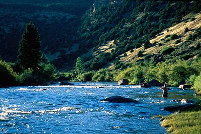
In his 23 years in the county, Wade said he has never experienced such a long paddling season on the Blue River as he did last year.

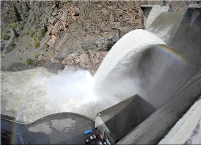
Wade said even if the weather patterns continue, he remains optimistic about the 2015 season. Paddlers are already enjoying flows on the Upper Colorado River, he said, and stand-up paddleboarding on Dillon Reservoir is growing in popularity.

“If nothing happens, we still will have water, we still will have river flow, there will still be business,” he said.

THE COLORADO PICTURE

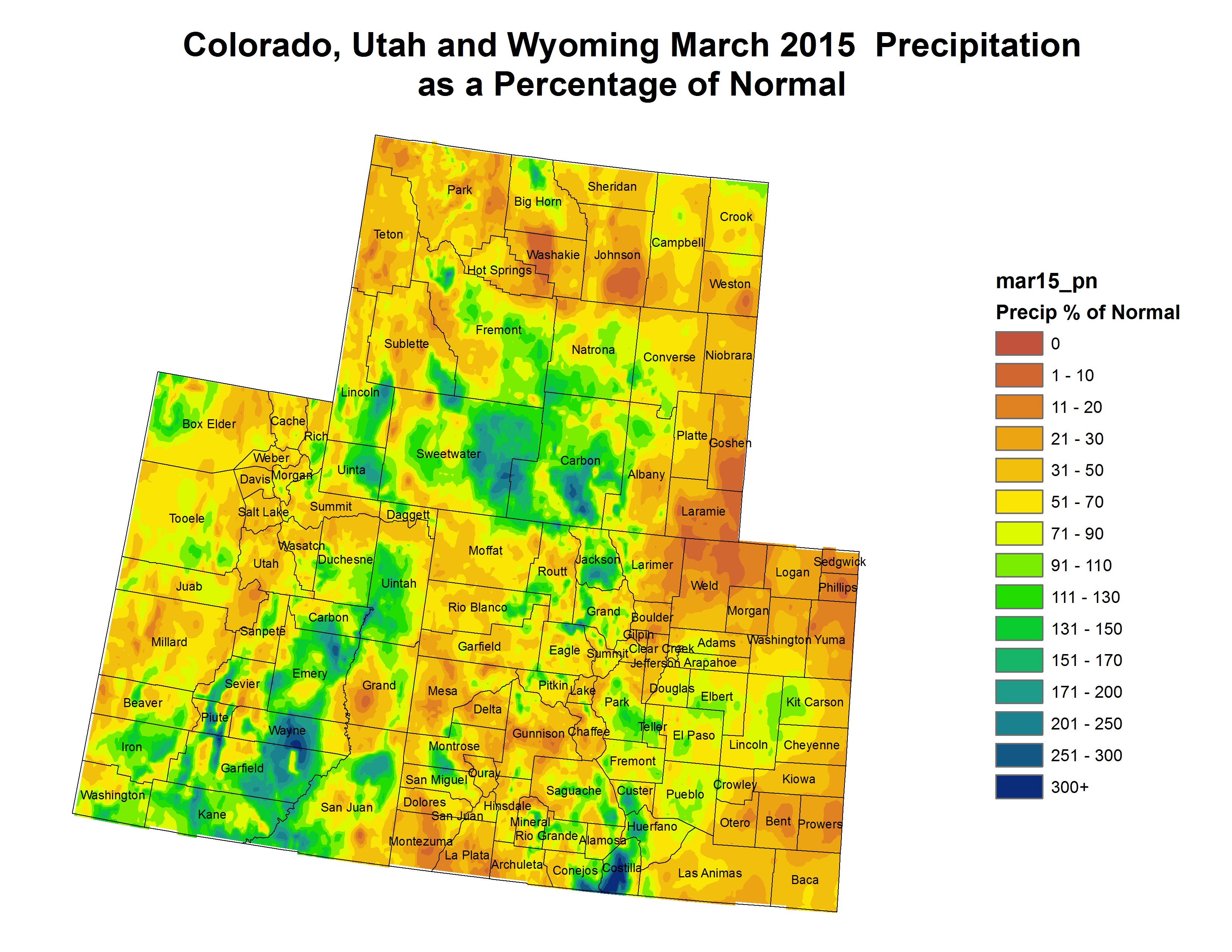
Statewide, a short-lived weather pattern in late February and early March resulted in snowpack gains, but the falling snow lasted only until March 6. Then the sky’s faucet shut off through the rest of March.

From March 6 through April 1, the state recorded the second-driest stretch for that time period dating to 1986; only 2012 was drier.

To compound the issue, warm early spring temperatures melted the snowpack, especially at lower and some mid-mountain elevations.

Seasonal snowpack decline this early in the spring is rare and occurs in one of every 10 years, according to a report produced by the Natural Resources Conservation Service (NRCS).

2012 was the extreme case in which snowpack melting began early and continued unabated through the spring due to above-normal temperatures.

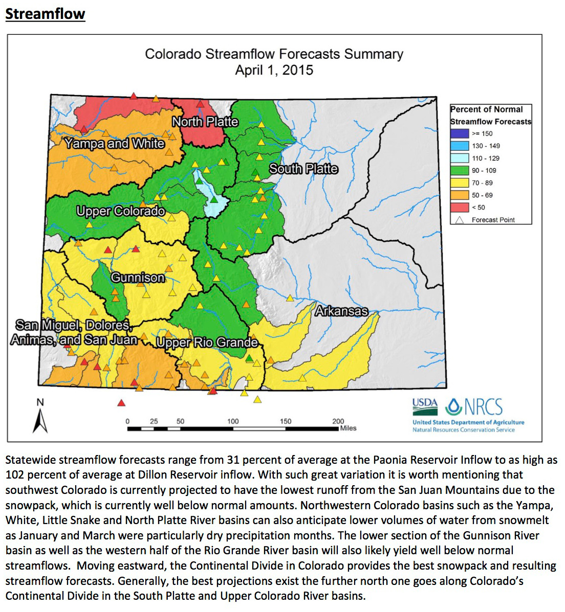
“While late-season snowstorms large enough to provide the kind of moisture we need in the mountains of Colorado are possible, they are not probable at this point,” said Brian Domonkos, hydrologist with the NRCS Colorado Snow Survey Program. “Coloradans and other downstream water users should be prepared for below-average streamflows this spring and summer.”

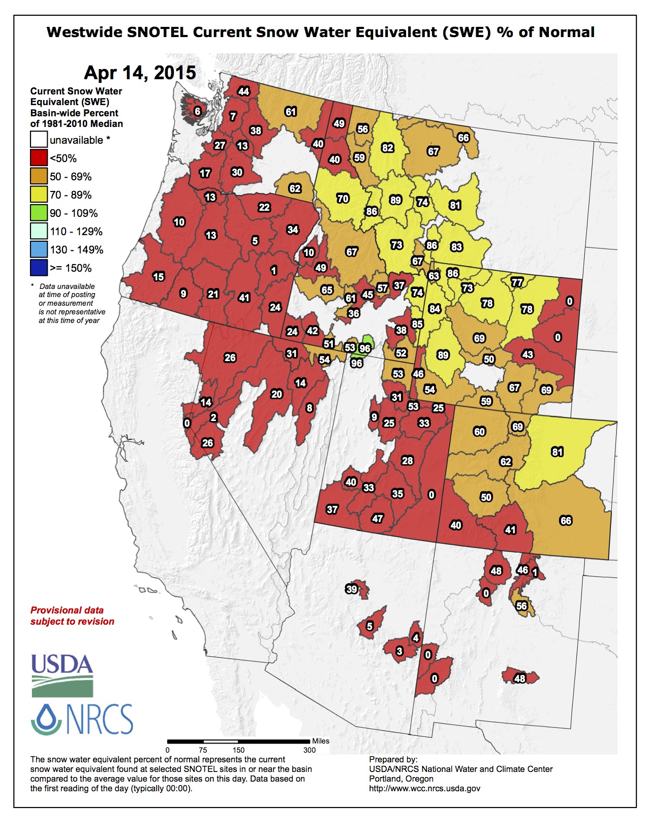
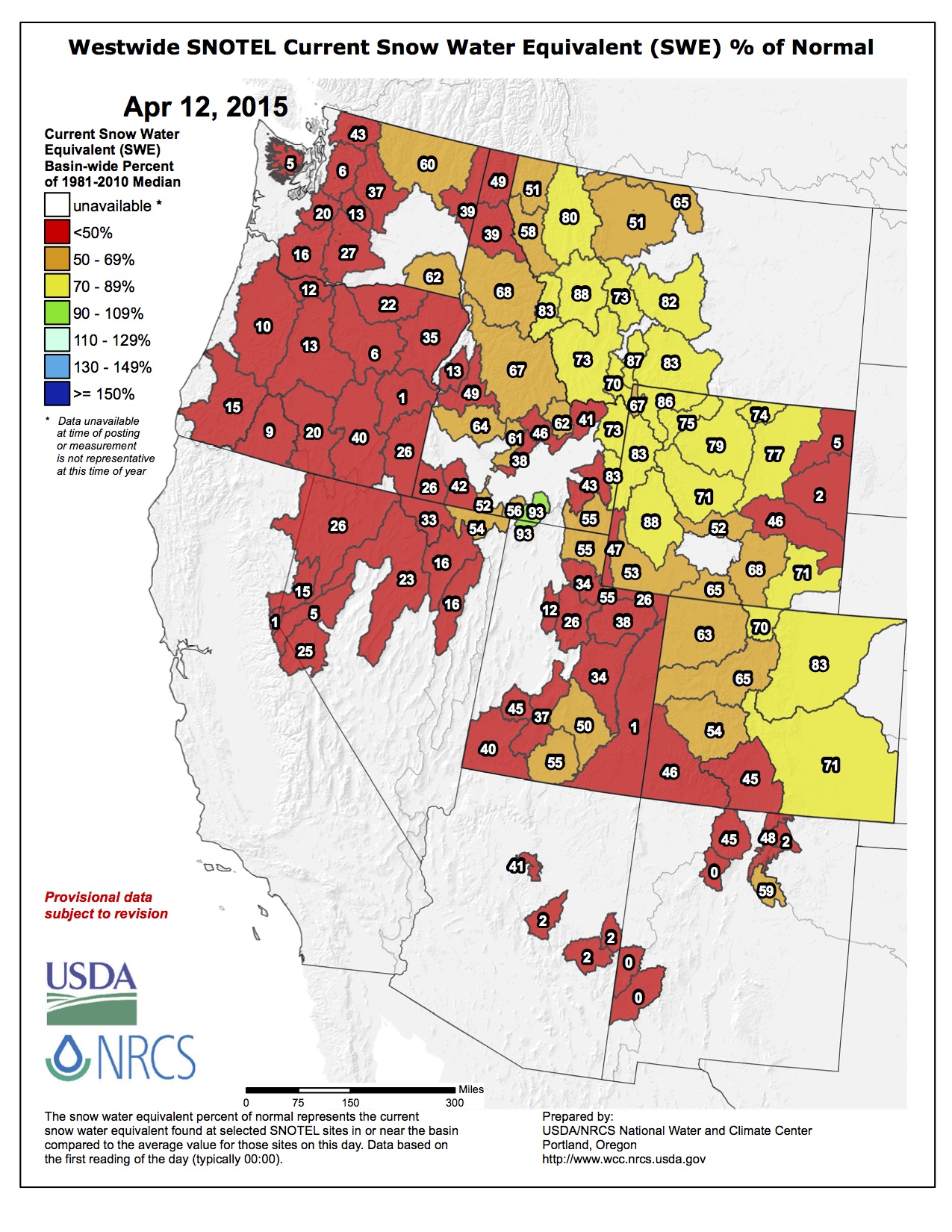
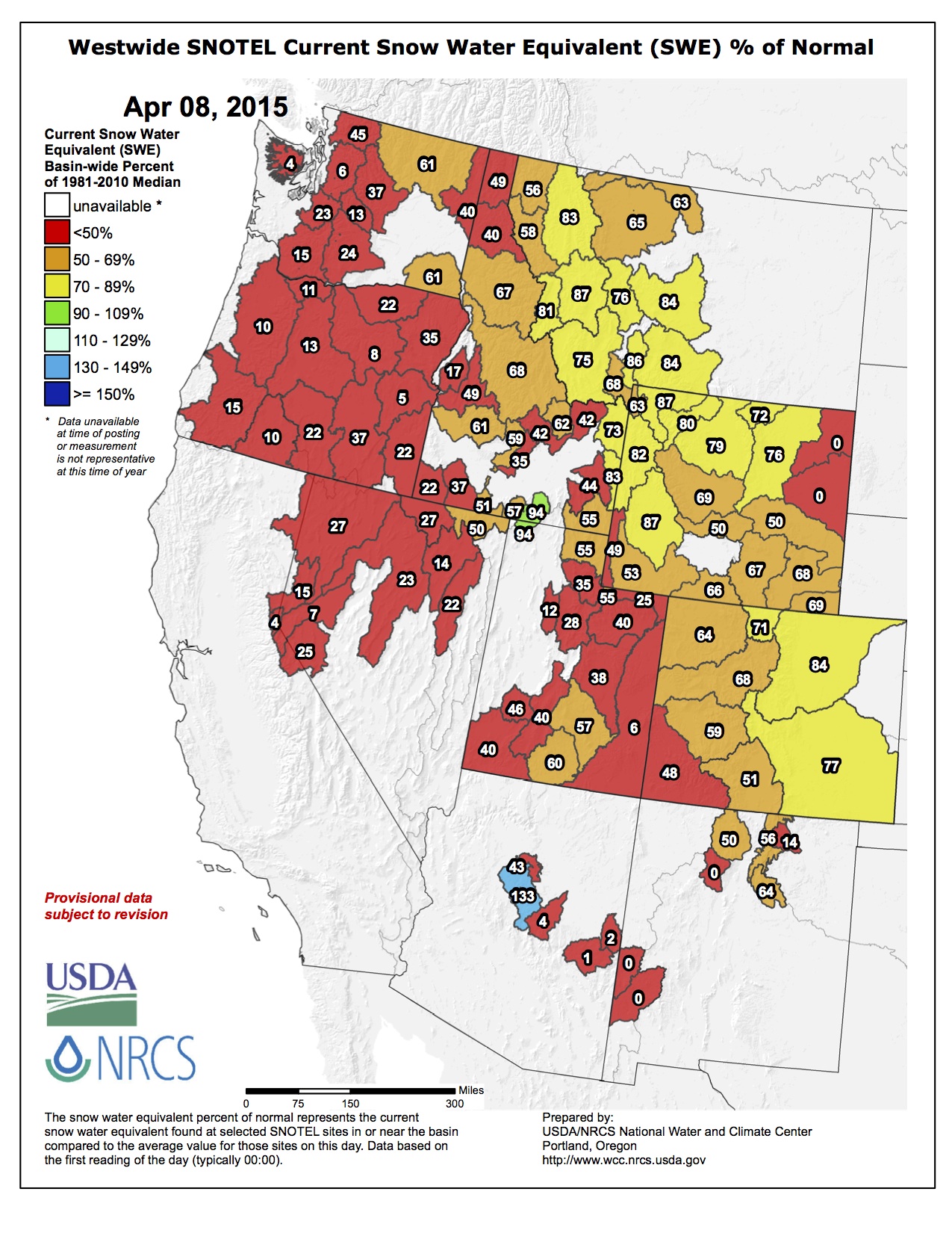
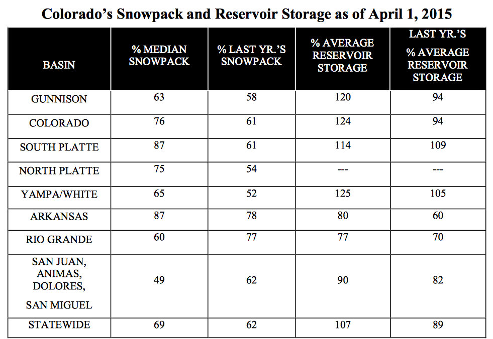
Statewide snowpack recorded on Wednesday, April 8, was 65 percent of normal, down from 87 percent last month, according to SNOTEL and snow course observation sites. That means this year’s snowpack ranks third from the minimum year of 2002 in a 30-year period of record.

The persistent bright spot in the state, the report said, is the South Platte River Basin where snowpack was 110 percent of normal last month. Though the South Platte experienced a large decline in March, it recorded the most snowpack of the state’s river basins on April 8 at 85 percent of normal.

“That means they won’t take as much down in Denver” from Summit, Wade said, referring to water pulled through the Roberts Tunnel in Dillon Reservoir by Denver Water to supply Front Range residents.

The Colorado River Basin, which includes Summit County, recorded an overall snowpack of 70 percent of average.

Colorado mountain snowpack typically peaks on April 9, but the NRCS report projected this year’s peak will have occurred one month earlier, closer to March 9, if warm temperatures and below-normal precipitation continue.

Snowpack deficits will negatively impact reservoir storage, which remains better in the northern half of Colorado while the southern half has stayed below normal.

“March is the second most significant month for mountain precipitation in Colorado. April is the most important, so if this dry trend continues through April, it would be a real one-two punch to Colorado’s water supply,” Domonkos said.

AT LOCAL SKI RESORTS

Summit’s ski resort officials have said early-season snow helped conditions through much of the spring despite much lower than average total snowfall.

Arapahoe Basin Ski Area reported that 100 percent of its easy, intermediate and difficult skiable acres were open Wednesday, while 84 percent of its expert terrain was open.

At Breckenridge Ski Resort, 99 percent of the terrain was open. Copper Mountain Resort was 67 percent open, and Keystone Resort, which closes Sunday, was 48 percent open.

Nearby, Loveland Ski Area was 91 percent open, Vail Mountain was 79 percent open and Beaver Creek, which also closes Sunday, was 43 percent open.

According to snowfall data reported by Breckenridge Ski Resort and compiled by OnTheSnow.com, the ski area was blessed with heavy snow for a few days in a row in mid-November and again right before the Thanksgiving holiday.

In December, Breckenridge reported 29 inches in two days just before Christmas and more snow before New Year’s.

The rest of the season has been slow for powder hounds.

January’s snowiest day at Breckenridge was the 20th, with 7 inches, and the ski area reported five days of 4 inches or more that month.

As is typical, February was snowier than January, but this year it wasn’t by much. February’s snowiest days at Breckenridge were Feb. 5 and 21, when the ski area reported 9 inches. That month saw seven days of 4 inches or more reported.

Then in March, the ski area reported its snowiest day on the 4th, with a meager 6 inches, and the month saw five days of 4 inches or more.

So far in April, local ski areas have recorded one powder day, on Friday, April 3, and none will extend its season. Last year every local ski area pushed back its closing dates.

San Miguel
 water rights 
are upheld
 — The Grand Junction Daily Sentinel

From The Grand Junction Daily Sentinel (Dennis Webb):

A Colorado Supreme Court ruling this week that upheld an instream flow water right in the San Miguel River in Montrose County also is being praised as an important one for the state’s instream flow program as a whole.

The court Monday ruled in favor of the Colorado Water Conservation Board in connection with its process for pursuing the water right for a 17-mile reach of the river. The board sought the right at the urging of the U.S. Bureau of Land Management and what is now Colorado Parks and Wildlife to preserve habitat for three sensitive fish species — the flannelmouth sucker, bluehead sucker and roundtail chub — and for “globally imperiled riparian communities.” A water court approved an instream flow protection of up to 325 cubic feet per second.

The Farmers Water Development Company had argued to the Supreme Court that the 
CWCB’s action was quasi-judicial, and as a result its notice and comment period failed to follow procedural due process. The high court found instead that the instream flow process is a quasi-legislative one that “concerns the rights of the people of Colorado, with a prospective policy focus on protecting the environment.”

The court’s opinion, written by Justice Allison H. Eid, said the legislature vested the CWCB with the exclusive authority to appropriate instream flows on behalf of state residents, and such an action is a policy determination within the agency’s discretion. The opinion also pointed out that the agency doesn’t decree instream flow rights, but decides whether to seek such a right from water court.

The Western Resource Advocates conservation group, which was a party to the case, called the ruling a landmark decision that will have a bearing on other instream flow applications by the CWCB.

“This is more than just a technicality. It’s about the very nature and strength of the instream flow program,” said WRA staff attorney Rob Harris.

CWCB director James Eklund said the decision affirms the agency’s instream flow program process. Had the court determined that the process is quasi-judicial, the agency would have to follow rigidly spelled-out proceedings involving legal pleadings and procedures, rather than its current system involving a hearing process involving a board, he said.

“Our board gets to ask the kind of questions they want to ask. There’s not as much in the way of getting them to the meat of the issue,” Eklund said. A quasi-judicial process would be more difficult for the agency to follow, he said.

Christopher Cummins, the attorney representing Farmers Water Development Co., could not be reached for comment.

Eklund said the ruling is important because the instream flow program “is the most robust tool that we have as a state to protect streamflows for the environment.”

“It does double duty for us,” he said, because it also protects flows at the state or local level, as opposed to the federal government doing so through Wild and Scenic River designations.

Western Resource Advocates said that, if not for instream flow protections, the fish to be protected in the San Miguel River might require protection under the Endangered Species Act.

Instream flow rights are nonconsumptive, aimed at maintaining minimum flows between points on a stream, or certain levels in natural lakes. According to the 
CWCB, since 1973 it has appropriated instream rights on more than 1,500 stream segments covering more than 8,500 miles of stream, and 477 lakes.

Eklund said the court ruling provides certainty to everyone involved in the instream flow rights process, including opponents to proposals. “You want to know the rules of the game when you get into it and this opinion helps provide some clarity on that,” he said.

Harris said the ruling will have some bearing on some big fights coming up this year on instream flow proposals, including one that ExxonMobil is challenging involving Yellow Creek in Rio Blanco County.

He noted that when it comes to allocation of water, instream flow rights are junior to rights already in existence before they were decreed. But he said some entities are seeking “carve-outs” that would give priority over instream rights to other water uses that haven’t even been come up with yet, and he objects to making instream rights second-class rights.

“Water rights for instream flows, they deserve a seat at the table like any other water right,” he said.

More water law coverage here.

Colorado Supreme Court ruling bolsters stream protection

@TODAYshow: Goldfish have taken over a lake in Boulder, Colorado

@H2OTracker: Can Drip Irrigation Save Humanity?

Arkansas Basin Roundtable: Land use planning should be tied to water availability in future development #COWaterPlan

Sprawl
Sprawl

From The Pueblo Chieftain (Chris Woodka):

Land use planning should be tied to water availability in future development, the Arkansas Basin Roundtable decided Wednesday.

That was one of three additions to the basin implementation plan the roundtable is completing as part of the state water plan, ordered in 2013 by Gov. John Hickenlooper. The meeting was held at Colorado State University-Pueblo.

The roundtable also added planks to support full development of Colorado’s entitlement under the Colorado River Compact and a watered-down preference for marketing water within the basin, rather than to the Denver area.

The roundtable unanimously agreed that land use planners must consider water resources when new development is proposed, a tough issue that has frequently arisen during the past two years of consideration of the state water plan.

“One of the ways we will better encourage water conservation is to work with local communities on land-use planning,” said Reed Dils, a retired outfitter and former member of the Colorado Water Conservation Board.

“We need to recognize how complicated it will be to achieve that end,” said Brett Gracely, water resources manager for Colorado Springs Utilities, who noted his own community’s attempts to integrate future water supplies and development. He did not oppose the addition to the plan, however.

The roundtable was not as cohesive on the issue of keeping water in the basin.

Dave Taussig, a water lawyer from Lincoln County, said he understood why water rights owners want to sell to water providers in the Denver area, in order to maximize value. But that would strip water from farms in the Arkansas River basin, harming the landscape and economy.

“Because it is so overap­propriated, water has to go to fill the gap in our basin before it’s sold to another basin,” Taussig said.

Most on the roundtable agreed with him.

“We have to make it attractive to leave water in the valley,” said Reeves Brown, a Beulah rancher and member of the Lower Arkansas Valley Water Conservancy District.

But others disagreed, saying the Arkansas River basin already imports water from the Colorado River, and that mechanisms to manipulate prices to keep water in the basin would drive up the prices artificially.

“I don’t know where you’re going to get the money to keep this valley green,” said John Schweizer, president of both the Catlin Canal and Arkansas Valley Super Ditch. “It sounds like a good idea, but I don’t think it will work.”

The final wording expressed only a “preference” for marketing water only within the Arkansas basin, and pledged the roundtable’s support to develop ways to make it more attractive to leave water in the basin.

Dan Henrichs, superintendent for the High Line Canal, opposed any steps to use water banks or other methods that might run afoul of Colorado water law’s prior appropriation system. He agreed to write a minority opinion.

The roundtable also adopted a simple statement that supports the state in achieving full development under the Colorado River Compact. Henrichs, Dils and SeEtta Moss, of the Arkansas Valley Audubon Society, opposed the option. Henrichs again argued for abiding by the prior appropriation doctrine, while Dils and Moss wanted to continue a collaborative approach with other roundtables.

On another Colorado River issue, the roundtable agreed to remain neutral on how existing transmountain diversions might be affected if future diversions from the Colorado River such as the Flaming Gorge pipeline are developed.

Water in the West and California’s drought: Why Colorado Springs should care — Colorado Springs Utilities

Colorado Springs circa 1910 via GhostDepot.com

From Re:Sources Blog (Patrice):

Living in the West offers many advantages. Wide open spaces, majestic mountains and amazing recreational opportunities, to name a few. Still, there are challenges and water is certainly one them.

If you’ve seen the recent news, extreme drought is taking its toll in California. In light of this, we caught up with our own water planners – Abby Ortega and Leon Basdekas – to learn if what’s taking place with our neighbors could affect our community and why we need to stay involved in what’s happening around the region.

Some of our customers many ask, could what’s taking place in California happen in Colorado?

Extreme drought can happen anywhere, and we are certainly not immune. We continuously monitor our water supply situation and maintain a storage reserve in our reservoirs to meet customer demand for at least one year.

Why should we take an interest in or follow what’s happening with drought in the West?

In Colorado Springs and across the Front Range, we are heavily reliant on the Colorado River for our water supply. The Colorado River starts in Colorado, but we only keep a portion of the flow for use in the state per the Colorado River Compact. The Colorado River also serves Arizona, Utah, Nevada, Wyoming, New Mexico and California (see below for a breakdown). There is also an obligation to Mexico. When any of the states or Mexico are in an extreme drought, their reliance on the Colorado River water may increase, possibly resulting in ripple effects that could negatively impact us. At any given time, the Colorado River supplies about 70 percent of our community’s water. Drought can also affect the levels in Lake Powell and Lake Mead, which part of the western United States relies on for power production.

Will Colorado Springs experience any impact from the situation in California?

The California drought will not have direct impacts to our community’s water supply yet. We are working closely with the Upper Basin States to create a proactive contingency plan in the event that storage levels in Lake Mead and Lake Powell drop to critical levels.

What is Colorado Springs Utilities doing to help protect our community from this type of situation?

Maintaining a dependable water supply for Colorado Springs residents and businesses is one of our community’s greatest challenges. Continuous long-term water planning is the reason we have a reliable water system today that supports our economy and quality of life. For us, planning is part of our daily responsibilities and includes factors such as water sources, demand, water rights, infrastructure, storage and much more. In addition, we are currently updating our Integrated Water Resource Plan, which provides the roadmap for sustainably addressing water supply and demand issues, while reflecting our community values.

What can customers do to help?

The intelligent use of water will always be a priority for our community, which has done a great job of adapting to our semi-arid climate. Our customers continue to find ways to use water wisely and we can help. A good place to start is our website, which has free xeriscape class schedules, efficiency ideas, DIY videos, and more. Folks should also join in the conversations we’re having through the Integrated Water Resource Plan process. There are opportunities for input, whether online or at upcoming meetings.

More Colorado Springs Utilities coverage here.

The April 1 Water Supply Outlook Report is hot off the presses from the NRCS, read it and weep

watersupplyoutlook0401205vianrcsstreamflow

watersupplyoutlook0401205vianrcssnowpackbybasin

Click here to read the report.

Aspinall Unit operations update

Crystal dam spilling May 2009

From email from Reclamation (Erik Knight):

Releases from Crystal Dam will be increased from 600 cfs to 750 cfs on Wednesday, April 8th at 8:00 AM. This release increase is in response to an increase in diversion to the Gunnison Tunnel. The current forecast for April-July unregulated inflow to Blue Mesa Reservoir is 480,000 acre-feet which is 71% of average.

Flows in the lower Gunnison River are currently above the baseflow target of 1050 cfs. River flows are expected to stay above the baseflow target for the foreseeable future.

Pursuant to the Aspinall Unit Operations Record of Decision (ROD), the baseflow target in the lower Gunnison River, as measured at the Whitewater gage, is 1050 cfs for April.

Currently, diversions into the Gunnison Tunnel are 300 cfs and flows in the Gunnison River through the Black Canyon are around 300 cfs. After this release change Gunnison Tunnel diversions will be around 400 cfs and flows in the Gunnison River through the Black Canyon should be around 350 cfs. Current flow information is obtained from provisional data that may undergo revision subsequent to review.

More Aspinall Unit coverage here.

Road to Jamestown open to all travelers for first time since 2013 flood — The Denver Post

Water Values podcast: Krausz USA President Tom Gwynn on US water infrastructure,

The latest Eagle River Watershed Council newsletter “The Current” is hot off the presses

eagleriver
Click here to read the newsletter. Here’s an excerpt:

Here in Colorado, we tend to think of precipitation in discrete, measured amounts: Inches of snow, cubic feet per second, acre feet of water. In an arid region often afflicted by drought, this is an understandable way to perceive our water situation. But if we dig deeper, the issues we face surrounding water are much more nuanced than simple measurements. Two other factors related to precipitation, the timing and type, are just as important as the amount, if not more so.

As any boater or skier will tell you, a storm bearing an inch of rain in July is very different from a system dropping an inch of rain in January. Though they may produce the same amount of precipitation, all storms are not created equally. Rain and snow are both welcome forms of precipitation and serve their own purposes, but the effects and consequences of each are quite different.

It is a classic case of “the tortoise and the hare.” Rain, the hare, moves quickly through watersheds, rapidly passing from cloud to ground to waterway and beyond. On the other hand, snow (the tortoise) stockpiles water in winter, gradually releasing it into waterways through spring runoff. Rain has more immediate benefits to and effects on the system, while the impacts of snow are on a time delay. I think we all remember who wins the metaphorical race.

For our rivers and streams and for our recreation-based economy, it is imperative that the majority of our annual precipitation (approximately 80 percent) comes in the form of snow. For a few important reasons, rain just won’t cut it.

NIDIS: Weekly Climate, Water and Drought Assessment for Colorado and the Upper #ColoradoRiver Region

Upper Colorado River Basin April 2015 precipitation as a percent of normal via the Colorado Climate Center

Click here to read the current assessment. Click here to go to the NIDIS website hosted by the Colorado Climate Center.

More Colorado River Basin coverage here.

The April 1 USDA – Natural Resources Conservation Service news release is hot off the presses

snowpackreservoirstorage04012015nrcs

Here’s the release from the Natural Resources Conservation Service (Brian Domonkos):

Significant snowpack gains in late February and early March were a result of a short-lived weather pattern lasting only until March 6th. Afterward, the proverbial faucet shut off yielding minimal precipitation through the remainder of March. The period of March 6th through April 1st 2015 was the second driest for the period of record dating back to 1986, only 2012 saw a drier March 6th through April 1st period.

To compound the issue, early spring temperatures this year have caused snowpack melt, observed most particularly at lower and some mid-elevation SNOTEL sites. Seasonal snowpack decline this early in the spring is rare and only occurs in one out of every ten years. Water year 2012 was the extreme case in which snowpack began melt and continued unabated for the remainder of the spring due to above normal temperatures.

“While late season snowstorms large enough to provide the kind of moisture we need in the mountains of Colorado are possible, they are not probable at this point.” said Brian Domonkos, hydrologist with the NRCS Colorado Snow Survey Program. Domonkos went on to say, “Coloradans and other downstream water users should be prepared for below average streamflows this spring and summer provided near or below average precipitation.”

Currently statewide snowpack is 69 percent of normal, down from 87 percent last month according to SNOTEL and snow course observation sites. This ranks Colorado mountain snowpack third from the minimum year in 2002 out of a 30 year period of record. The persistent bright spot in the state is in the South Platte River basin where snowpack was 110 percent of normal last month. While the South Platte did experience a large decline in percent of normal snowpack during March, it remains tied for the best snowpack in the state as of April 1 at 87 percent of normal, along with the Arkansas.

April 9 is typically the time of year when Colorado mountain snowpack is peaking or experiencing it highest values of the winter season. If the warm temperatures and below normal precipitation continues, that peak this year will have occurred closer to March 9.

Some watersheds have considerable reservoir storage, but this will likely not be enough to offset the snowpack deficits. Reservoir storage remains better in the northern half of the state while the southern half remains below normal. “March is the second most significant month for mountain precipitation in Colorado. April is the most important, so if this dry trend continues through April, it would be a real one-two punch to Colorado’s water supply.” suggests Domonkos.

Snowpack/runoff news: The San Miguel, Dolores, Animas, and San Juan watersheds turn red (<50% of normal)

Click on a thumbnail graphic to view a gallery of snowpack data from the Natural Resources Conservation Service.

From Rocky Mountain PBS INews (Jim Trotter):

The so-called Snotel readings, which measure the moisture content of snowpack, are a product of the Natural Resources Conservation Service in the U.S. Department of Agriculture. They started in the late 1970s, and now have 885 reading sites Westwide. The percent of average is based on the last 30 years.

In Colorado, the lowest readings are in the southwest quadrant of the state, at 54 percent of average. The highest reading is at 88 percent of average on the South Platte basin side of the northern and central Rockies.

Particularly along the ranges in the Pacific Coast states, the readings are disastrous, of course, for summer water supplies to both urban areas and agriculture, and set up the potential for another brutal fire season.

And it’s not inappropriate for us to feel a little apprehension, as we wait for what April will bring.

From The Aspen Times (Scott Condon):

Colorado’s overall snowpack is the third worst in 30 years for this time in April, according to the Natural Resources Conservation Service.

The snowpack is down to 69 percent of normal. It fell from 87 percent of normal one month ago, the federal agency said.

In addition to the dry conditions, spring temperatures are higher than normal, so the snowpack is disappearing earlier than usual, according to the conservation service…

The snowpack disappeared rapidly throughout the Roaring Fork River basin after a series of storms dumped about six feet of snowfall on slopes in two weeks during late February and early March. The snowpack in the headwaters of the Roaring Fork River is 89 percent of average. In the Fryingpan Valley, the snowpack completely melted at Nast Lake, which is at 8,700 feet in elevation, according to the conservation service. The snowpack is still at 93 percent at Ivanhoe Reservoir, which is at 10,400 feet in elevation.

The snowpack is only 64 percent of normal at Schofield Pass at the headwaters of the Crystal River. It’s at 44 percent at the North Lost Trail snowpack measurement site near Marble.

March came in like a lion but ended like a lamb for Aspen Skiing Co. ski areas. Snowmass received 54 inches of snow during the month, about 90 percent of average, according to company spokesman Jeff Hanle. Aspen Mountain received 41 inches or 77 percent. Aspen Highlands received 44 inches or 80 percent. Buttermilk collected 25 inches or 50 percent of average, Hanle said.

From CBS Denver:

“We’re the headwater state to 18 downstream states and the country of Mexico, so when we do anything on water issues everybody notices,” James Eklund with the Colorado Water Conservation Board said.

Colorado snowpack is currently only 65 percent of average, but where that water is heading is a different story.

Right now the Colorado reservoirs are 108 percent of average.

“We’re actually better this year storage-wise than we were last year,” Eklund said.

“We need to really be cautious, we live in a dry state, you never know what the next year or even the summer will bring, so it’s just smart to use water efficiently,” Stacy Chesney with Denver Water said.

Denver Water services nearly 25 percent of the state’s population, but only uses 2 percent of the water. This year its resources are in the wettest parts of the state.

“Denver Water supply is actually in pretty good shape at this point, and that’s thanks to normal snowpack in our collection area, as well as reservoir levels that are higher than average, and really efficient water use by our customers,” Chesney said.

“If California has another year like they have this year, then we need to have that plan stood up and ready to go,” Eklund said. “So time is of the essence.”

State officials say they’re learning quite a bit from California. The state is in the works of finalizing the Colorado water plan so in case of a dangerously dry year water officials will know what to do.

Hoover Dam turns 80 this month — @westgov

Your Input is Shaping the Clean Water Rule — EPA Connect

Fen photo via the USFS

From EPA Connect (Gina McCarthy and Jo-Ellen Darcy):

Water is the lifeblood of healthy people and healthy economies. We have a duty to protect it. That’s why EPA and the U.S. Army Corps of Engineers are finalizing a Clean Water Rule later this spring to protect critical streams and wetlands that are currently vulnerable to pollution and destruction. On April 3 we sent the draft rule to the Office of Management and Budget for interagency review. Since it’s not final yet, we can’t speak to every detail. But the spirit of this rule boils down to three facts:

First, people depend on clean water: one in three Americans get their drinking water from streams currently lacking clear protection.

Second, our economy depends on clean water: manufacturing, farming, ranching, tourism, recreation, and other major economic sectors need clean water to function and flourish.

Third, our cherished way of life depends on clean water: healthy ecosystems support precious wildlife habitat and pristine places to hunt, fish, boat, and swim.

A year ago, our agencies released the draft Clean Water Rule. Since then, we’ve held more than 400 meetings across the country and received more than one million public comments from farmers, manufacturers, business owners, hunters and anglers, and others. The input helped us understand the genuine concerns and interests of a wide range of stakeholders and think through options to address them. In the final rule, people will see that we made changes based on those comments, consistent with the law and the science. We’ve worked hard to reach a final version that works for everyone – while protecting clean water.

We’re confident the final rule will speak for itself. But we can broadly share some of the key points and changes we’re considering.

  • Better defining how protected waters are significant. A key part of the Clean Water Rule is protecting water bodies, like streams and wetlands, which have strong impacts downstream – the technical term is “significant nexus.” We will respond to requests for a better description of what connections are important under the Clean Water Act and how agencies make that determination.
  • Defining tributaries more clearly. We’ve heard feedback that our proposed definition of tributaries was confusing and ambiguous, and could be interpreted to pick up erosion in a farmer’s field, when that’s not our aim. So we looked at ways to refine that definition, be precise about the streams we’re talking about, and make sure there are bright lines around exactly what we mean.
  • Providing certainty in how far safeguards extend to nearby waters. The rule will protect wetlands that are situated next to protected waterways like rivers and lakes, because science shows us they impact downstream waters. We will provide a clear definition about what waters are considered adjacent waters.
  • Being specific in the protection of the nation’s regional water treasures.
  • We heard concerns that the category we called “other waters” in the rule was too broad and undefined. We’ve thought through ways to be more specific about the waters that are important to protect, instead of what we do now, which too often is for the Army Corps to go through a long, complicated, case by case process to decide whether waters are protected.
  • Focusing on tributaries, not ditches. We’re limiting protection to ditches that function like tributaries and can carry pollution downstream—like those constructed out of streams. Our proposal talked about upland ditches, and we got feedback that the word “upland” was confusing, so we’ll approach ditches from another angle.
  • Preserving Clean Water Act exclusions and exemptions for agriculture. We will protect clean water without getting in the way of farming and ranching. Normal agriculture practices like plowing, planting, and harvesting a field have always been exempt from Clean Water Act regulation; this rule won’t change that at all.
  • Maintaining the status of waters within Municipal Separate Storm Sewer Systems. Some state and local governments raised questions about waters within these permitted systems. We listened carefully as we did not intend to change how those waters are treated and have considered ways to address this concern. We will also continue to encourage the use of creative solutions like green infrastructure and low-impact development, as many of these communities have advocated.
  • The public will see that the agencies listened carefully and made changes based on their input. That’s how an open and collaborative process works – so we can ensure everyone’s voices are heard, in a way that follows the law and the latest science. Our mission is to uphold that commitment to the American people.

    We may have different opinions on how we best protect our water resources, but we can all agree that clean water matters, and that it deserves our protection. The health of our people, our economies, and our way of life deserve protection. That’s what the Clean Water Rule is all about.

    About the authors: Gina McCarthy is the U.S. EPA Administrator and Jo-Ellen Darcy is the Assistant Secretary of the Army (Civil Works).

    More Environmental Protection Agency coverage here.

    Landmark Legal Decision Protects Rivers and Instream Flows — Western Resource Advocates

    From Western Resource Advocates (Rob Harris/Joan Clayburgh):

    Today the Colorado Supreme Court rendered a landmark decision upholding the “instream” water right for the breathtaking San Miguel River.

    The court deemed that a senior water rights holder, Farmers Water Development Company, is unaffected by the State of Colorado’s instream water rights on the San Miguel river and affirms that state water rights are a legitimate and essential tool to protect Colorado’s fish and wildlife.

    “We’re ecstatic that the Colorado Supreme Court upheld permanent protection for this scenic river in Colorado’s Red Rock Canyon country,” said Rob Harris, Staff Attorney at Western Resource Advocates (WRA) and WRA’s lead defender before the Supreme Court. “Healthy rivers are important for wildlife and recreation. This case will long be remembered for preserving healthy rivers throughout Colorado as a legacy for future generations. Fishermen, boaters, and wildlife need these sorts of instream water right protections secure water for their needs.”

    In 2013, the Water Court in Montrose ruled in favor of the Colorado Water Conservation Board’s application for “instream flow” protection that permanently safeguards water flowing in the San Miguel River for fish. This will also benefit recreational users. The San Miguel River is one of the last relatively free-flowing rivers in Colorado. The Water Court approved an instream flow protection of up to 325 cubic feet per second, enough to support the vulnerable native fish in the San Miguel.

    Farmers Water Development Company challenged this decision, claiming their water right would be negatively impacted, which today the Supreme Court found to be incorrect.

    “We are proud of the part we’ve played legally defending this instream flow water right,” said Rob Harris. “We believe this ruling not only protects the distinctive San Miguel, but ensures we have a vital tool to leave a legacy of healthy rivers throughout Colorado. We thank the Colorado Water Conservation Board, Colorado Parks and Wildlife, the Bureau of Land Management and our tireless partners in the conservation community who helped make today’s victory possible.”

    The San Miguel River is unique, rising in the San Juan Mountains southeast of Telluride and flowing through San Miguel and Norwood canyons, then past Placerville and Nucla – joining the Dolores River in Montrose County. This river is renowned for exciting whitewater boating and tremendous trout fishing.

    This visually stunning river flows through Colorado’s red sandstone canyon country and is also home to three native fish that are struggling to survive.

    Without dedicated instream flows in the San Miguel and elsewhere, these fish could require protective action under the federal Endangered Species Act. Colorado’s Instream Flow Program allows for a fair, collaborative process where local stakeholders have a voice in protecting Colorado’s rivers and streams, and the San Miguel water rights reflect that approach.

    Instream water rights help keep water in a river or lake. The rights dedicate minimum water flows between specific points to preserve or improve the natural environment. These can be used to protect fisheries, waterfowl, frogs/salamanders, unique geologic or hydrologic features and habitat for threatened or endangered fish. The rights can be monitored and enforced, thereby insuring long-term protections.

    The legal challenge by Farmers Water Development Company would have threatened the continued vitality of Colorado’s Instream Flow Program, and today’s decision allows all current and future in- stream flow protection efforts to continue.

    More San Miguel watershed coverage here and here.

    CWCB: The next Water Availability Task Force meeting is April 15

    April drought outlook via the Climate Prediction Center
    April drought outlook via the Climate Prediction Center

    From email from the Colorado Water Conservation Board (Ben Wade):

    The next Water Availability Task Force meeting will be held on Wednesday, April 15, 2015 from 9:30-11:00a at the Colorado Parks & Wildlife Headquarters, 6060 Broadway, Denver in the Bighorn Room.

    The agenda has been posted at the CWCB website.

    More CWCB coverage here.

    Snowpack/runoff news: Pueblo has no plans for watering restrictions

    Click on a thumbnail graphic to view a gallery of snowpack data from the Natural Resources Conservation Service.

    From The Colorado Springs Gazette (Ryan Maye Handy):

    Western Slope reservoirs that provide water to Colorado Springs Utilities are comfortably at average, but Utilities will be watching the spring runoff, said Steve Berry, a Utilities spokesman. If runoff levels are low, Utilities will focus on water levels for 2016, Berry said.

    This year had a good start when it comes to water levels in southern Colorado. Record snowfall in February made for high snowpack levels in the Arkansas River Basin.

    Although snowpack levels around the state can’t compare to the extremely high levels of 2014, Colorado is at 67 percent of its average snowpack statewide, the latest measurements from the Natural Resources Conservation Service show.

    But March has shifted the positive outlook. Drought encroached on Colorado in March, and the latest runoff forecasts to be released this week are expected to offer a poor prognosis for runoff in the south and southwestern parts of the state.

    From FOX21News.com (Aisha Morales):

    Twice a month Mark Hanratty heads up the mountain in Homestake Valley near Tennessee Pass.

    “The season so far has been just above average we started out way above average because we had good early snows,” said Mark who measures snowpack totals.

    While snow in town is great, Colorado Springs Utilities really has its eye on what’s happening up here.

    “We take the water from here through a tunnel that goes underneath the Continental Divide, and flows into tourquiose resevoir, so we’re bringing water to our community in Colorado Springs from nearly 200 miles away,” said Abby Ortega, planner with Colorado Springs Utilities.

    From The Pueblo Chieftain (Chris Woodka):

    While California is bracing for record drought, the Arkansas River basin in Colorado will probably see a fairly typical year when it comes to water supply.

    “We have no plans to implement restrictions,” said Alan Ward, water resources manager for the Pueblo Board of Water Works. “Conditions here are certainly nothing like in California.”

    Pueblo gets some of its water from the Colorado River basin, which is in a long-term drought. But the area from which Pueblo takes water is in relatively good condition, compared with the rest of the basin.

    Snowpack in the Upper Colorado River basin is just 74 percent of median, but key sites to Pueblo Water’s collection system range from 84-103 percent, according to the Natural Resources Conservation Service Snotel sites.

    The Arkansas River basin snowpack is 80 percent of normal, but sites in the Upper Arkansas, which provides streamflow to the river later in the year, is at 95 percent.

    The Cucharas and Purgatoire basins are only at 58-69 percent.

    In all cases, snow at lower elevations already has begun to melt.

    Pueblo Water also has plenty water in storage, about 40,000 acre-feet (13 billion gallons), or more than a year’s supply. Pueblo is leasing water this year in order to make space to refill its reservoirs.

    “Our philosophy going forward is that we’re trying to avoid rationing and inconveniencing our customers,” Ward said. If storage is drawn down in the next year, Pueblo Water could cut spot leases, as it did in 2013. “We’re trying to avoid doing that as well. It’s a supplemental source for farmers.”

    The outlook for the next three months calls for wetter than usual conditions in Colorado, according to the National Weather Service. Water watchers are having a hard time believing that, since March was supposed to fall into that category, but came up dry. As it is, Pueblo precipitation for the year is slightly above average, thanks to record snow in February, but lagging behind last year.

    Farmers who have filed augmentation plans, either for wells or surface supplies, should get all they asked for this year, said Steve Witte, Division 2 engineer for the Colorado Division of Water Resources. The state will monitor water conditions before giving final approval on June 1. “We’ve not altered the plans,” Witte said.

    The Bureau of Reclamation has scaled back its projections for imports through the Fryingpan-Arkansas Project, to 53,000 acre-feet. That’s down from 68,560 acre-feet at the beginning of March and assumes normal conditions from here on out, said Roy Vaughan, Fry-Ark manager.

    “Our workers are already opening the system with heavy equipment,” Vaughan said.

    Runoffs have been occurring earlier than they have historically for the past eight years, and most of the snow from lower elevations has melted in the Fry-Ark collection system, Vaughan said.

    The #ColoradoRiver in the Grand Canyon is American Rivers’ #1 endangered river for 2015

    Click here to go to the American Rivers website. here’s an excerpt:

    Colorado River in the Grand Canyon

    Arizona
    Millions of Americans recognize the Grand Canyon as one of the most iconic landscapes on the planet. But this natural masterpiece of the Colorado River faces a battery of threats.

    A proposed industrial-scale construction project in the wild heart of the canyon, radioactive pollution from uranium mining, and a proposed expansion of groundwater pumping at Tusayan, all threaten the Grand Canyon’s wild nature and unique experience that belongs to every American.

    Unless the Department of the Interior acts to stop these threats, one of our nation’s greatest natural treasures will be scarred forever.

    Click here to read the report.

    Is The Public Engaged When It Comes To Colorado’s Water Plan? — KUNC #COWaterPlan

    Colorado Water Plan website screen shot November 1, 2013
    Colorado Water Plan website screen shot November 1, 2013

    From KUNC (Maeve Conran):

    …despite an extensive education and outreach campaign, just how involved is the general public in planning Colorado’s water future?

    Kate McIntire, the women in charge of public engagement and outreach for the Colorado Water Conservation Board, said they’ve mostly relied on volunteers in a process that goes back 10 years when the Public Education, Participation and Outreach group was established. Later, McIntire said, they engaged the nine basin roundtables to help.

    “This is really a grassroots process and so we never intended to or didn’t have millions of dollars to throw into reaching everyone across the state in terms of a more traditional advertising campaign,” said McIntire. “Spreading the word grass roots isn’t something that happens overnight.”

    The Water Board received more than 15,000 comments directly and through the nine basin roundtables when creating the draft plan. That’s not enough for state Senator Ellen Roberts, a Republican from Durango. She still thinks there’s a lack of awareness amongst the general public.

    “I think that’s the challenge that we saw here at the legislature,” said Roberts. “The Governor and the executive branch of the Colorado government has done a lot of outreach but it’s a topic that most people… all they really care about is when they get up in the morning does water come out of the shower, can they make their cup of coffee or cup of tea?”

    In 2014 the senator co-sponsored a successful bill that called for more involvement by the legislature in water planning. That led to a series of public meetings in all the major river basins of Colorado.

    “What we were trying to do with Senate Bill 14-115 [.pdf] last year was to go out to the more general public, the kind of people who show up at our town hall meetings, who maybe have no idea about Colorado water law or how complicated it is,” Roberts said. “They’re not following like the people on the basin roundtables.”

    Theresa Connelly, a water advocate with Conservation Colorado, is heartened by what she sees as a growing awareness in water issues in the state, even if there’s a lack of awareness about an actual water plan.

    “Folks may not know as much that there’s an actual state water plan going on, but folks are very aware of water issues that we’re facing,” she said.

    But Connolly, like Senator Roberts, said the public outreach effort needs to be more inclusive. She cites the fact that many of the meetings were in the middle of the workday, which made it difficult for some to attend. People may not have time to attend a meeting, but maybe they’ve sent an email or a postcard, and those voices should also be heard.

    “I think sometimes those small actions are disregarded as a form letter or something that isn’t truly meaningful and I think that that’s absolutely not true,” Connelly said.

    The Colorado Water Conservation Board has received over 2000 comments in the first few months since the draft was submitted and adds all input received through May 1 will be considered in the second draft, said the board’s McIntire. She points out that the CWCB is responding to all comments received and those responses are available for public review.

    “And all those responses are cataloged and available for review by anyone on our website.”

    More Colorado Water Plan coverage here.

    Wyoming’s 10 year cloud-seeding experiment scrutinized

    Cloud-seeding graphic via Science Matters
    Cloud-seeding graphic via Science Matters

    From the East Oregonian (Allen Best):

    Wyoming just spent $14 million and the better part of 10 years on a rigorous scientific experiment to evaluate whether it’s possible to get extra snow from winter storm clouds through cloud seeding. The conclusion? The final results were thin: There was a 3 percent increase in precipitation, but a 28 percent probability that the cloud seeding had nothing to do with it.

    Given the results of this and other winter weather-modification studies, the Bureau of Reclamation remains unimpressed. “As such,” said the agency in a draft analysis released in February, “the ‘proof’ the scientific community has been seeking for many decades is still not in hand.”

    Proof in science requires a 95 percent probability of causality. But this standard is extremely difficult to achieve in complex atmospheric processes. Climate scientists, for example, mostly resort to asterisk-laden words such as “likely” to indicate lower levels of probability…

    From the start, Wyoming’s cloud-seeding experiment was designed to ensure scientific rigor. Parallel mountain ranges southwest of Laramie, just north of the Colorado border, constituted the Wyoming laboratory. Propane was burned to loft silver iodide from ground-based generators into the clouds passing over the Sierra Nevada and Medicine Bow ranges. In the experiment, 154 storms during six winters had the temperatures needed for effective seeding, but only 118 developed adequate moisture content. And of those, 18 were tossed out because of contamination problems.

    Dan Breed, project scientist with the National Center for Atmospheric Research, which designed and oversaw the Wyoming experiment, said that failing to achieve a 95 percent confidence level in results is not unusual in cloud seeding studies. The fundamental problem, he says, involves the difficulty of measuring atmospheric processes.

    The challenge inherent in the complexity of the data has prevented most climate scientists from directly linking specific weather events, such as the September 2013 floods in Colorado, to rising global temperatures, or even to the 3 to 5 percent observed moisture in the global atmosphere.

    “When it comes to the atmosphere, there are just too many variables, and that variability just keeps rearing its ugly head when it comes to cloud seeding,” says Breed. “Even in this case, where we tried to make things as homogeneous as possible to reduce that variability, variability still kind of hurt us.”

    Breed thinks research might better be invested in understanding the interaction in the atmosphere of wind, temperature and precipitation. For example, how likely is it that silver iodide or other seeding agents released from the ground will get into the clouds? True understanding of atmospheric processes, says Breed, has mostly come from observations instead of experiments — because of that same variability.

    This lack of certainty does not necessarily kill the prospects of cloud seeding, as is demonstrated by the continued interest of Wyoming legislators in funding projects. In the Colorado River Basin, cities and water districts seized upon the modeled projections of 5 to 15 percent snowpack augmentation as justification for continued or even expanded operations. Already, metropolitan Los Angeles, the Central Arizona Project and the Southern Nevada Water Authority, among others, pay for seeding clouds in Colorado, the source of half the water in the Colorado River, and last year they also paid to seed clouds in Wyoming, in the Green River drainage.

    More cloud seeding coverage here.

    Club 20 Annual Meeting recap

    George Washington addresses the Continental Congress via Son of the South
    George Washington addresses the Continental Congress via Son of the South

    From The Colorado Statesman (Ron Bain):

    A panel of seven Western Slope legislators — six Republicans and one Democrat — discussed diverse issues they’re working on in the state legislature at the Club 20 annual meeting on March 28, focusing on water, energy, the economy, TABOR and federal lands…

    Preventing the Front Range from taking more Western Slope water was a popular theme during the panel discussion.

    “We’re protecting West Slope water,” said Sen. Ray Scott, R-Grand Junction. “This is your front line of defense.”

    Rep. J. Paul Brown, R-Ignacio, called for the Front Range to impound and store more of its own water.

    “We keep sending more and more water to the Front Range,” Brown said. “I think water storage is important. The study of the South Platte is important.”

    The last time the Front Range considered building a dam was 25 years ago, when the proposed Two Forks project was vetoed by the Environmental Protection Agency. The Denver Post recently called for water storage to be added to Gov. John Hickenlooper’s draft Colorado Water Plan.

    “Our water infrastructure was dramatically cut back,” Roberts said. “You can’t build towns on air. You have to have water.”

    “I’ve always been an advocate for storage,” Baumgardner said. “We must have storage or we’re going to have a huge problem.”

    Coram said 400,000 acre feet of water could be conserved if “water thief” non-native species such as tamarisk and the Russian olive were eliminated.

    Swan River restoration

    Restoration plans are afoot for a degraded section of the Swan River, in Summit County, Colorado.

    From 9News.com (Matt Renoux):

    If all goes as planned, the Swan River between Frisco and Breckenridge will once again run like it did more than a century ago.

    That’s because the Colorado Water Conservation Board and Colorado Basin Roundtable have given Summit County a $975,000 grant to restore 19 miles of the river that was drastically changed by mining activity…

    The overall plan is restore the part of the river that’s separated by the huge dredge piles – and hopefully bringing back fish and wildlife in the area – returning it to how it was more than a hundred years ago.

    More restoration/reclamation coverage here.

    #ColoradoRiver: “When do we say no, and who do we say no to?” — Mark Squillace

    Colorado River Basin including out of basin demands -- Graphic/USBR
    Colorado River Basin including out of basin demands — Graphic/USBR

    From the Mountain Town News (Allen Best):

    By its natural flow, the Colorado River originates in Rocky Mountain National Park and ends in the Sea of Cortez. But flows of the Colorado decades ago ceased to be natural, as Phil Fradkin famously captured in his 1981 book “A River No More.”

    A discussion on April 3 sponsored by the University of Colorado Law School’s Environmental Law Society examined two aspects of the unnatural flows. All three speakers, in different ways, talked about different management regimes for water revolving around the adage of “just add water.”

    Since 1999, Jennifer Pitt has shepherded efforts on behalf of the Environmental Defense Fund to restore flows to the river’s delta in Mexico. Water has not reached the sea with regularity since the 1960s and, until special releases last spring, not at all since the late 1990s.

    Eric Wilkinson talked about the diversions of the river and its tributaries to cities along the Front Range of Colorado and to benefitting farms at least as far downstream as the Nebraska and Kansas borders. He’s general manager of the Northern Colorado Water Conservation District, which administers the single largest diversion across the Continental Divide, the Colorado-Big Thompson Project.

    Introducing the session, law professor Mark Squillace framed the primary issue of the Colorado as one of management that recognizes inherent limits and demands choices: “When do we say no, and who do we say no to?”

    The two giant reservoirs on the Colorado, Powell and Mead, together were at 94 percent of capacity in 1999. By 2007, that storage had dropped to 54 percent of capacity.

    This year looks even worse: 42 percent of storage capacity for the two reservoirs, and more decline as the year progresses look inevitable. The National Oceanic and Atmospheric Administration this year projected runoff in the Colorado River to be just 52 percent of normal. “Things are not looking good,” Squillace said.

    “Are we facing a crisis?” he asked rhetorically, before answering his own question: “I would suggest it’s not a water crisis. It’s a management crisis.”

    In talking about the successful effort to return water to the river delta in Mexico during March 2014, Pitt described a long, evolving process that essentially began in 1999 with a study that found that ecosystem functions in the river delta could be restored with just 1 percent of annual flows. Securing that water for a successful pulse of water last year required persistence and new levels of cooperation.

    Wilkinson continued Pitt’s theme. “Everything you do with water takes time,” he said.

    The Colorado-Big Thompson Project itself took time. It was conceived in at least some vague ways in the late 1890s as farmers in the South Platte Valley of northern Colorado noted insufficient water for late-summer irrigation. Recurrence of drought in the 1930s added argument for a giant, federally funded capital works project. Work began in 1938 on Green Mountain Reservoir, to serve needs of the Western Slope, but final work was not completed until 1957.

    This and other diversions from the Colorado River headwaters have created a thriving economy along the Front Range. Weld County, the largest in the basin, is 8th in the nation in total agricultural production. By itself, Weld County produces more than all 20 counties on Colorado’s Western Slope combined.

    All this belies the impression of Zebulon Pike who, upon encountering the high plains leading up to the Rockies, made comparisons to the deserts of Africa. “Just add water,” Wilkinson advised. He said that two-thirds of irrigated acres in Colorado get at least some of their water from the Colorado River.

    The munificence of Colorado River water extends to the cities of the Front Range corridor, where about 85 percent of Coloradans live, mostly in the fast-urbanizing strip along I-25 north from Denver. The Front Range, said Wilkinson, represents 80 to 86 percent of Colorado’s economic activity.

    Wilkinson’s description of Colorado’s transmountain infrastructure was a story of triumph. The future, he acknowledged, is far more muddled.

    One outstanding issue is whether Colorado can expect to divert substantial amounts of additional water from the Colorado River and its tributaries. It’s not clear how much Colorado has left of its apportionments as specified by two major compacts governing the Colorado River, the seven-state compact of 1922 or the 1948 compact among the four headwaters states.

    But even if there is water, said Wilkinson, there are additional questions: “If so, how do you develop it, and if so, how do you develop it in ways that protect basins of origin and still make the project economical?”

    Then there’s this simple fact: existing diversions are not an absolute. They depend upon volumes of water in the river to meet compact requirements—and deepening drought could throw even long-standing diversions off the rail.

    Responding to a question about California’s drought, Wilkinson said that he is “scared” that the federal government—administrator of the compact—will someday force curtailment of diversions with appropriation dates after 1922. That would include the Colorado-Big Thompson.

    As the northern Front Range looks to add 2.5 million people during the next 35 years, the equivalent of the existing Denver-Boulder metroplex, there will be questions of where the water will come from. There is, said Wilkinson, a “disconnect” between the people who provide water and the people who approve residential developments.”

    All this points to a new era of water management, as opposed to the “just add water” mantra of the mid-20th century.

    Snowpack/runoff news: The South Platte Basin is still the best in the state = 86% of the median

    Click on a thumbnail graphic to march across the water year Westwide SNOTEL’s.

    Meanwhile The Durango Herald is reporting that snowpack in the southwestern watersheds has dropped to 54% of normal. Here’s an excerpt:

    The Colorado statewide snowpack stands at 69 percent of average while the Colorado River basin, which supplies some of the water to lower-basin states, including California, is at 76 percent of average.

    Conditions are even more critical in Southwest Colorado where the snow/water equivalent in the existing snowpack is 54 percent of the 30-year median as of Friday. Looking at year-to-date precipitation in the same region – which doesn’t account for snow-water equivalency or melting – that was 67 percent of average as of Friday…

    Strong wind such as has occurred in recent days could bring dust to Southwest Colorado, including its snow-covered mountains, A covering of dust is undesirable because the dark coating absorbs heat, causing the snow to melt more quickly.

    https://twitter.com/DanElliottAP/status/584100382458150912

    San Miguel River: Restoration project will reverse channelization

    Photo via TellurideValleyFloor.org
    Photo via TellurideValleyFloor.org

    From The Telluride Daily Planet:

    One of the biggest human impacts on the Valley Floor was the channelization of the once-meandering San Miguel River approximately 125 years ago, pushing the waterway into an unnatural straight line on the western edge of the valley. That crime against nature could be reversed in a $1.6 million plan presented to Telluride Town Council on Tuesday.

    The ambitious engineering project would focus on a section of the river from the sewer lagoons near Entrada to Boomerang Road, restoring the flow to the historic route of the river — a pathway that can be seen in old photographs and is hinted at in the current topography of the 570-acre green space.

    “What we’re doing in this situation is we’re actually moving the flow path of the San Miguel River,” said Dave Blauch, a senior ecologist for Ecological Resource Consultants, Inc., a group that is assisting in the river restoration project. “The concept has been to pull it out on the Valley Floor to function more naturally.”

    Blauch told council members of the many environmental benefits that the project would create: the restoration of approximately 5,000 linear feet of aquatic and riparian habitat, the elimination of a highly unnatural water channel, the restoration of natural flood cycles and the improvement of the natural habitat.

    The new — but really quite old — river channel would be cut with excavation equipment and the project would be a disruptive sight to see on the protected land while underway.

    Hilary Cooper, a member of the committee focused on the river restoration project, told council members that the benefits of the project would far outweigh one season of construction disruption.

    More San Miguel River watershed coverage here.