
Month: April 2015
HB15-1259 (Residential Precipitation Collection Rain Barrels) heads to Senate Ag Committee April 16 #coleg

From The Greeley Tribune (James Redmond):
Although a number of Republicans joined Democrats in passing a bill in the House that could end Colorado’s ban on rain barrels, the legislation now awaits its first Senate committee hearing, where some Republicans remain wary of its possible long-term effects.
The Senate Agriculture, Natural Resources, and Energy Committee will hold a hearing for House Bill 1259 on April 16.
The bill passed out of the House with an easy bipartisan majority, 45-20, on March 23. It could have become a partisan issue, as no Democrats voted against it. But more than 10 Republicans cast a yes vote, with some calling it common sense legislation and saying rain water will go back into the ground anyway.
Many Republicans did not support the bill, which some say could cause issues with Colorado’s law of prior appropriation and potentially hurt water rights holders, such as farmers to whom they say the rainwater belongs.
But, some House Republicans who supported the bill represent counties with substantial agricultural interests, such as Weld County’s Rep. Steve Humphrey, R-Severance, and Rep. Lori Saine, R-Dacono.
Similarly, farmers and other professional and experts connected to water issues in Colorado have expressed views ranging from concern to support of the bill.
Sen. John Cooke, R-Greeley, a member of the Senate Agriculture, Natural Resources, and Energy Committee, hasn’t made up his mind about the bill yet, but he said Thursday he feels leery of voting for it and has not heard much from his constituents yet.
“You know, it looks like it’s a pretty innocuous bill,” he said. “Most people might say ‘hey why can’t we collect water off our own roof?’”
But if everyone took advantage of what the bill would allow and 50,000 homes in the Greeley and Evans areas started collecting rainwater, it could hurt the already over-appropriated South Platte River, Cooke said. Hurting the river could mean people with water rights do not get the water they are entitled too, he said.
“I’m not saying I’m opposed to the bill yet; I want to hear the testimony,” Cooke said.
Currently people cannot collect and store rainwater from roofs in Colorado. The bill would allow someone to collect and keep rain from his or her roofs in up to two 55-gallon barrels. Rainwater collected this way could only be used for outdoor purposes, such as lawn irrigation and gardening.
“The data we were given indicates that 97 percent of the water that comes off of roof tops never actually makes its way into the basins,” Rep. Dave Young, D-Greeley, said Wednesday. “I thought it made good sense.”
If most rooftop rainwater does not make its way into the system as it is now, Young said he would need to see data that showed how rain barrels negatively affect someone’s prior appropriation before he sees the bill as harmful to water rights owners.
Most of the northern Colorado legislators supported it the bill, he said, and of Weld County’s House representatives, only Rep. Perry Buck, R-Windsor, voted against the bill.
“I struggled with that bill,” Buck said Friday. She had concerns about the legality of letting people collect rainwater and how that could affect agriculture.
Although some people say most of the rainwater from roofs does not go into water basins, she said allowing all houses to collect and store their rainwater could negatively affect water rights owners.
Experts in the field have expressed concerns about broadly allowing all houses to collect their rainwater.
“My concern is this bill could result in injury to vested senior water rights,” said Robert Longenbaugh, a retired assistant state engineer and ground water specialist. Without requiring rain barrels to receive site-specific consideration, “I believe the potential is there for injury.”
Colorado has more demand for water than ever before, and a rain barrel takes away water, he said.
Glen Fritzler, a farmer who works near Gilcrest, thinks the bill could probably hurt farmers.
“It just seems like taking from the end users,” Fritzler said.
Not all farmers feel the same way. LaSalle farmer Harry Strohauer said the bill seems like common sense to him. Letting residents collect rainwater in insignificant amounts means they can put it to good use and avoid using other water sources.
“I don’t see a downside to that,” he said.
Conservation Colorado has also come out in support of the legislation, claiming the bill will raise awareness of Colorado’s water challenges and the need for water conservation polices.
The bill could set a nasty precedence, Cooke said, and if it does pass it could be hard to change it back. It would take hard work with stakeholders to find a different version to satisfy everyone, he said.
Water forum targets pumping in Colorado — Salina Journal

From the Salina Journal (Tim Unruth):
Kansas Gov. Sam Brownback and a few water-conscious underlings plan to discuss with locals Tuesday in St. Francis how water is being used in a three-state region.
Water from the Ogallala Aquifer, the huge underground driver of farm economies in portions of several states, is being mined to satisfy federal streamflow requirements on the Republican River.
Rep. Rick Billinger, R-Goodland, wonders about the wisdom of taking a resource that developed over centuries to enhance a river, losing some of the resource to seepage and evaporation.
“It makes no sense,” he said. “Here we are, trying to get a new vision out to preserve water for 50 years, and we have Colorado across the line, pumping from the Ogallala to replace surface water.”
The meeting will begin at 10:30 a.m. at the Cheyenne County 4-H Building in St. Francis.
Billinger aims to gather input on the pumping project and “possible ways to preserve the Ogallala for future users.”
Two similar augmentation projects just ceased in two areas of western Nebraska.
The Republican River Water Conservation District in northeast Colorado is pumping from eight irrigation wells into a pipeline that dumps into the north fork of the Republican. The district delivers 7,000 acre feet of water to the river from November through December, and from January through mid-April will pump another 7,000 acre-feet, said Deb Daniel, manager of the district based in Wray, Colo…
“The only way we can supply enough water to be in compact compliance is by delivering water to the stream,” she said.
Another effort to comply consisted of draining Bonny Reservoir northeast of Burlington during 2011 and 2012. It was the only lake in the region.
Evaporation and seepage from the lake were working against Colorado’s compliance, Daniel said…
Rep. Billinger argues that the pumping project benefits the north fork of the Republican, which doesn’t enter Kansas until it reaches Jewell County, in the north-central part of the state. The south fork dips into Kansas through Cheyenne County and flows back into Nebraska.
Among Billinger’s options is to influence Colorado to stop pumping water from the Ogallala to replace surface water.
Hoping for long-term solutions
The Kansas lawmaker also would advocate for Colorado putting water back in Bonny Reservoir, earmarking storage for Kansas, and enhancing the region’s fishing and other recreation opportunities.
Given the demands for compliance, Colorado’s Daniel said the district “didn’t have any choice.”[…]
Representatives from Daniel’s district are planning to attend the Tuesday meeting in St. Francis. NRD officials from Nebraska also are interested in what’s said at the meeting, Jenkins said, and some may attend.
Accompanying Brownback will be Kansas Agriculture Secretary Jackie McClaskey, Chief Water Engineer David Barfield and Kansas Water Office Director Tracy Streeter.
Meanwhile the Republican River Water Conservation District board meeting is next Thursday. From the Yuma Pioneer (Tony Rayl):
Yuma will be the site for the Republican River Water Conservation Board of Directors regular quarterly meeting, Thursday, April 9.
It will be held in the banquet room at Quintech, 529 N. Albany St. from 10 a.m. to 4 p.m. Public comment will be heard at 1 p.m.
A discussion regarding negotiations with the Jim Hutton Educational Foundation is on the agenda. The board will discuss possible financial support to the Water Preservation Partnership, as well as membership in the Colorado Foundation for Water Education, along with other matters.
Pipeline operator Tracy Travis will give a report, and the board will hear reports on other recent meetings and programs. The board holds out the right to have an executive session if necessary.
For further information, please contact RRWCD General Manager Deb Daniel at 332-3552, or on her cell phone at 630-3525, or email her at deb.daniel@rrwcd.com.
EPA dials back use of dangerous systemic pesticides
Environment: EPA to start tracking nanoscale chemicals
Environment: Methane emissions from pipelines declining
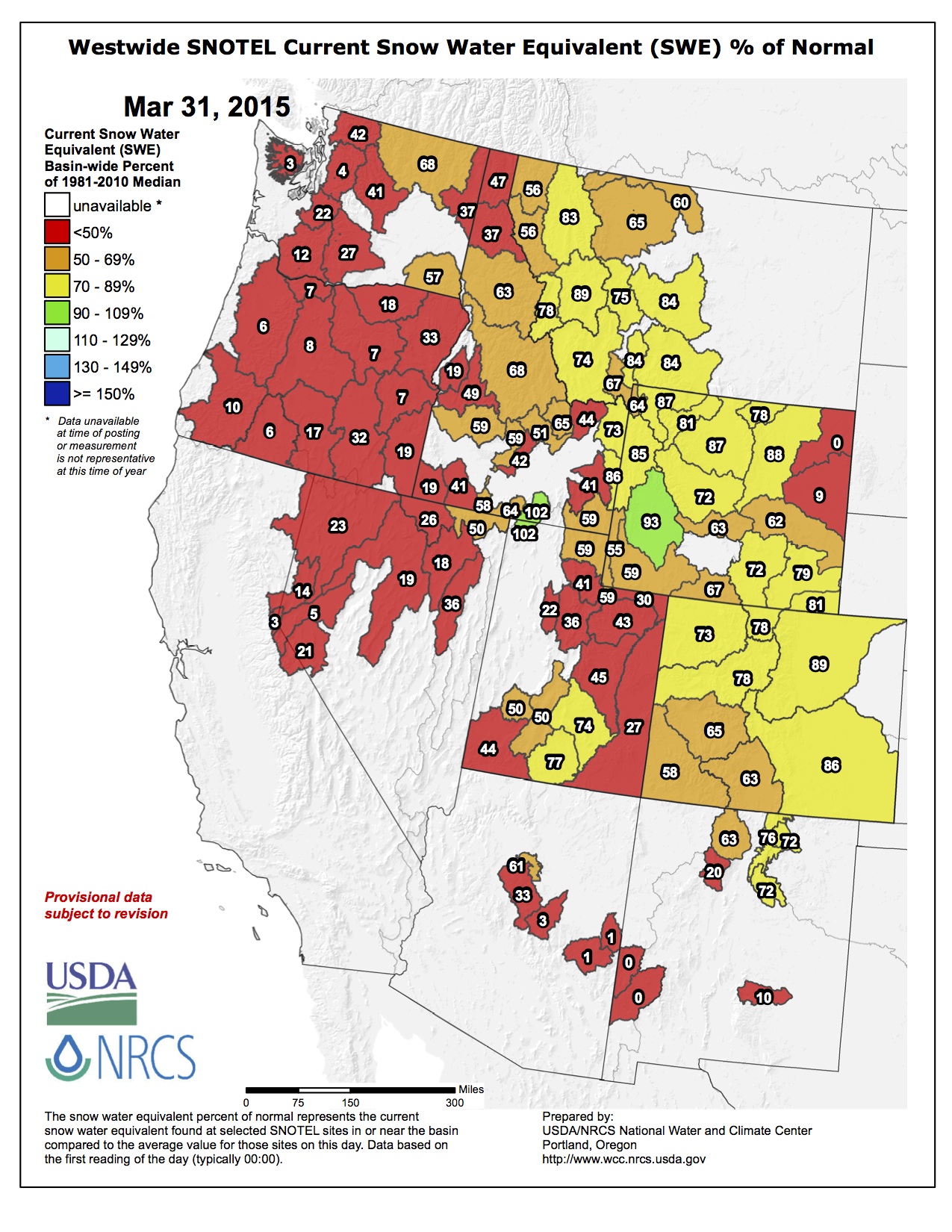
Snowpack news: April to June forecast for inflows to Lake Powell = 52% of avg. #ColoradoRiver

Statewide snowpack map April 2, 2015 via the NRCS

Arkansas River Basin High/Low graph April 2, 2015 via the NRCS

Upper Colorado River Basin High/Low graph April 2, 2015 via the NRCS

Gunnison River Basin High/Low graph April 2, 2015 via the NRCS

Laramie and North Platte Basin High/Low graph April 2, 2015 via the NRCS

Upper Rio Grande River Basin High/Low graph April 2, 2015 via the NRCS

South Platte River Basin High/Low graph April 2, 2015 via the NRCS

San Miguel, Dolores, Animas, and San Juan Basin High/Low graph April 2, 2015 via the NRCS

Yampa and White Basin High/Low graph April 2, 2015 via the NRCS
From InkStain (John Fleck):
The April-July runoff forecast into Lake Powell, on the Arizona-Utah border, is just 52 percent of the long term mean, according to new numbers out today from the Colorado Basin River Forecast Center.
That is roughly 1.3 million acre feet less water flowing into Lake Powell than the forecast of just a month ago, the result of a hot, dry March. That means at the end of said runoff period, Powell will be roughly 13 feet lower than it would have been otherwise, according to my half-assed amateur calculation (danger, danger, journalist doing math! – the pros at the Bureau of Reclamation will give us a more reliable number next week).
From the Pagosa Springs Sun (Renita Freeman):
The Natural Resources Conser- vation Service (NRCS) reported that the San Juan River Basin was at 51 percent of median on April 1, com- pared to 63 percent in the March 1 report. Snowpack reports generated by the National Resource Conserva- tion Service (NRCS) show that the San Juan Basin snowpack was down 19 percent from last month.
According to data provided by SNOTEL, the report listed three measurements. The first was the Upper San Juan, with snow depth of 37 inches, and a current median of 47 percent compared to 74 per- cent last year. Vallecito, with a snow depth of 22 inches, was listed at 53 percent as compared to 90 percent median for last year, and Wolf Creek Summit, with a snow depth of 43 inches, was listed at 56 percent as compared to 76 percent median last year.
According to the Colorado Water Supply Outlook report on the United States Department of Ag- riculture site, “Forecasts of any kind are not perfect. Streamflow forecast uncertainty arises from three primary sources: (1) uncer- tain knowledge of future weather conditions, (2) uncertainty in the forecasting procedure, and (3) er- rors in the data. The forecast, there- fore, must be interpreted not as a single value but rather as a range of values with specific probabilities of occurrence.”
From the Estes Park Trail-Gazette (Pamela Johnson):
Snowpack in the South Platte River basin sits at 89 percent of average, while the Upper Colorado basin is recording 78 percent of average at automated sites. Numbers from sites that are measured manually will be released within the next few days, but cumulative snowpack figures have remained below average over the past months…
In Loveland, only 0.37 inches of precipitation fell in March, or 23 percent of average, according to Wendy Ryan, assistant state climatologist at Colorado State University. Over the past three months, 2.24 inches was recorded in Loveland, or 85 percent of normal. During the same time, Loveland’s temperatures were 2.4 degrees above average, according to Ryan…
Brian Werner, spokesman for Northern Water, said storage levels in the Colorado-Big Thompson Project and other local reservoirs remain at all-time highs.
From 9News.com (Whitney Wild):
Coming off the snowiest February on record, the National Weather Service calls March a dud. The dry spell melted the statewide snowpack from 87 percent of average at the end of February to 69 percent as of Thursday.
“When we talk about snowpack, and we talk about drought, and we talk about how much rain is going to fall, the state doesn’t act all in sync,” NWS meteorologist Bob Glancy said…
In southwest Colorado, the reservoirs are below average and well-below capacity. North of the metro-Denver area, reservoirs are above average but slightly below capacity.
Meanwhile here’s a report about the low snowpack from Bruce Finley writing for The Denver Post:
Colorado’s mountain snowpack is running low — around 69 percent of average — raising concerns about low stream flow during summer and potential strain on water supplies. A relatively hot, dry March took a toll, melting away snowpack from 87 percent at the end of February. The latest data under review by the federal Natural Resources Conservation Service survey team on Thursday showed statewide snowpack at 69 percent of average, with snowpack in southwestern Colorado basins dropping to 55 and 58 percent of average.
In the closely watched Colorado River Basin, snowpack was measured at 76 percent, the early data show. The South Platte River Basin, which supplies metro Denver and northeastern Colorado, had snowpack at 88 percent of average. The Arkansas River Basin was at 83 percent of average…
Water storage in reservoirs statewide measured at 90 percent of last year’s level on March 1. Federal hydrologists had yet to compile the latest water levels in reservoirs.
#Drought news: Drought intensifies over Colorado

US Drought Monitor March 31, 2015

West Drought Monitor March 31, 2015

Colorado Drought Monitor March 31, 2015
Click here to go to the US Drought Monitor website. Here’s an excerpt:
Summary
Rain was heaviest across the nation’s mid-section as well as parts of the Northwest and eastern U.S., while intensifying dryness was noted in the Southeast and from the northern Great Lakes and Upper Midwest to the central and southern Pacific Coast, including the Great Plains. Much-above-normal temperatures accelerated crop-water demands on the Plains and further reduced already-dire mountain snowpacks over much of the West. Dryness also increased in the Northeast, though lingering cold mitigated the impacts of the precipitation deficits somewhat…
Central Plains
Dry, unseasonably warm weather maintained or worsened drought over the central Plains for a second consecutive week. With sunny skies and temperatures approaching or topping 80°F from southeastern Colorado into Kansas and central Nebraska, drought conditions remained or intensified. In particular, pronounced dryness over the past 6 months (30-50 percent of normal) across south-central and northern Nebraska supported the expansion of Moderate (D1); the Standardized Precipitation Index (SPI, a station-based drought indicator) over the same time period in these locales averaged -1.0 to -1.7 (D1-D3 equivalent) indicating conditions may rapidly deteriorate if rain fails to materialize soon. Elsewhere, light showers (generally less than half an inch) in eastern portion of the region afforded little – if any – drought relief…
Northern Plains
Light to moderate rainfall on the northern-most Plains was in sharp contrast to increasing dryness and drought farther south. Locally more than an inch of rain in North Dakota was sufficient to prevent further expansion of Abnormal Dryness (D0) or Moderate Drought (D1), though precipitation over the past 6 months remained well short of normal (30-60 percent of normal). Farther south, above-normal temperatures (daytime readings in excess of 80°F) and a lack of much-needed rain resulted in expansion of D1 in southern South Dakota; precipitation in South Dakota’s new D1 area averaged 25 to 50 percent of normal over the past 6 months, which equated to a Standardized Precipitation Index (SPI, a station-based drought indicator) equivalent over the same time period of D1. Likewise, soil moisture rankings remained unfavorably low over much of southern and eastern South Dakota, and streamflows – which benefited from recent snow melt – have begun to drop rapidly…
Southern Plains and Texas
Worsening drought in the north contrasted with heavy rain and drought reduction in the south and east. Across western Oklahoma and northern Texas, sunny skies, daytime highs approaching or topping 90°F, and occasionally gusty winds caused Moderate (D1) to Extreme (D3) Drought to intensify. Soil moisture and streamflow rankings remained at or below the 5th percentile in the southern Plain’s core drought areas, while the satellite-derived Vegetation Health Index indicated rapidly declining conditions from the Texas Panhandle into northern Oklahoma. Farther east, locally more than an inch of rain afforded some relief from drought in northeastern Oklahoma. Farther south, additional assessment from the field indicated some reduction of Abnormal Dryness (D0) was warranted near Victoria, Texas, while drought coverage and intensity remained unchanged northwest of Austin as reservoir levels struggled to rebound due to a pronounced long-term drought impacts…
Western U.S.
The overall trend toward drought persistence continued, with drought intensification noted over the eastern Great Basin and central Rockies. The west continued to cope with much-above-normal temperatures, further depleting already-dire snowpacks and reducing spring runoff prospects over much of the region.
In the north, additional Pacific moisture and weekly average temperatures up to 10°F above normal resulted in moderate to heavy showers (1-4 inches, locally more) in orographically favored portions of the Cascades and northern Rockies. However, plentiful water-year precipitation (since October 1) in the Northwest remained in sharp contrast to virtually non-existent snowpacks, with the snow-water equivalents less than 25 percent of normal (locally less than 10 percent) across Oregon as well as southern and northwestern Washington. The lack of snow maintained concerns for spring and summer water supplies despite the generally favorable 2014-15 water year.
Across the Great Basin and Four Corners States, drought intensified in northern portion of the region but remained unchanged elsewhere. In particular, Severe Drought (D2) expanded over northeastern Nevada, where water-year precipitation (since October 1) has averaged less than 50 percent of normal the northwest; the Standardized Precipitation Index (SPI, a station-based drought indicator) over the same time period in this location averaged -1.3 to -2.0 (D2-D4 equivalent) indicating conditions will likely deteriorate further if rain and mountain snow fail to materialize soon. In Colorado, D2 was increased as low SNOTEL percentiles, low snowpack, and high temperatures are having an impact in the state; snow-water equivalent (SWE) in the state’s D2 areas are now consistently at or below the 10th percentile, and locally below the 5th percentile. Meanwhile, conditions remained unchanged in the southern Four Corners Region, where Water Year precipitation has been generally higher than locales farther north.
In California, there were no changes to this week’s depiction as the state entered a fourth consecutive year of drought. With temperatures averaging more than 10°F above normal for the week, snowpacks continued to dwindle; as of April 1, the state’s total snowpack stood at a meager 5 percent of average. Indicative of the virtually non-existent snowpack, streamflows have dropped into the 5th percentile or lower over much of California. In addition, the 2014-15 Water Year has ended on an abysmal note, with precipitation over the past 30 days totaling a mere 10 percent of normal or less from Redding southward. Even with some precipitation in the forecast across central and northern California, any rain and mountain snow – while welcomed – would likely do little to improve the state’s dire drought prospects…
Looking Ahead
Rain from the lower and middle Mississippi Valley into New England will contrast with mostly dry conditions across the Southeast and Gulf Coast as well as from the Plains into the Southwest. A strong cold front will bring temporary relief from unseasonable warmth over the Plains, though above-normal temperatures will return by the weekend. Rainfall associated with the front will be light on the Plains, and generally confined to central and northern-most portions of the region. However, rain will intensify as the cold front marches east, with 5-day totals of 1 to 3 inches possible from the northern Delta into the Ohio Valley and Northeast. In contrast, dry conditions are expected from the Carolinas to the immediate Gulf Coast. Out west, some showers and high-elevation snow will overspread the Northwest during the weekend, while the Southwest and Four Corners Region remain dry. The NWS 6- to 10-day outlook for April 7–11 calls favorably cooler- and wetter-than-normal weather from the Pacific Coast into the Great Basin, including California. Likewise, wetter-than-normal weather is also expected from the Mississippi Valley and Gulf Coast States into the Northeast. In contrast, drier-than-normal conditions will prevail across the Rockies and Great Plains. East of the Rockies, abnormal warmth over southern portions of the Corn Belt and Mid-Atlantic States will contrast from cooler-than-normal weather across the northern Great Lakes and New England.
Here’s the monthly drought outlook for April from the Climate Prediction Center.

Reclamation Signs Lease of Power Privilege with the Northern Water Hydropower Water Activity Enterprise for Granby Dam in Colorado #ColoradoRiver

Here’s the release from the Bureau of Reclamation (Patience Hurley):
Reclamation announced today that Great Plains Regional Director Michael J. Ryan signed a Lease of Power Privilege for Granby Dam located near Granby, Colorado.
The LOPP authorizes Northern Water Hydropower Water Activity Enterprise development of a 1.2 megawatt hydropower plant at the base of Granby Dam, a west-slope feature of the Colorado-Big Thompson Project. The project utilizes a “run of dam” design that harnesses water releases from Granby Dam to generate power and provide a clean, renewable source of energy to north-central Colorado.The final environmental assessment and Finding of No Significant Impact are available at http://www.usbr.gov/gp/ecao/nepa/granby_hydropower.html or you may request a paper copy by contacting Patience Hurley at (701) 221-1204.
More Colorado-Big Thompson Project coverage here.
Video: #onedayindenver about Denver’s water supply & its future
.@site07 @douglaskoke create #onedayindenver video about Denver's water supply & its future: http://t.co/SAlF5K2N0l
— Denver Water 💦 (@DenverWater) April 2, 2015
Reaching Colorado and getting in the game about the state water plan
Snowpack/runoff news: Snowpack on Grand Mesa low for April 1, Sangres melting out

Statewide snowpack map Basin High/Low Graph April 1, 2015 via the NRCS

Arkansas River Basin High/Low Graph April 1, 2015 via the NRCS

Upper Colorado River Basin High/Low Graph April 1, 2015 via the NRCS

Gunnison River Basin High/Low Graph April 1, 2015 via the NRCS

Laramie and North Platte Basin High/Low Graph April 1, 2015 via the NRCS

Upper Rio Grande River Basin High/Low Graph April 1, 2015 via the NRCS

San Miguel, Dolores, Animas, and San Juan Basin High/Low Graph April 1, 2015 via the NRCS

South Platte River Basin High/Low Graph April 1, 2015 via the NRCS

Yampa and White Basin High/Low Graph April 1, 2015 via the NRCS
Click on a thumbnail graphic to view a gallery of snowpack data from the Natural Resources Conservation Service:
From the Grand Junction Free Press (Stephanie Kampf):
Throughout the West, communities and farms rely on melting snow for water supply. Each year, water managers track mountain snowpack levels in the spring to forecast the water supply for the summer growing season. For decades, snowpack conditions measured on or around April 1 have been used to generate river flow forecasts that inform water supply plans.
As of late March, the Snow Telemetry (SNOTEL) stations operated by the Natural Resource Conservation Service are showing very low snow conditions in many parts of the west. In drought-stricken California, the snow water equivalent (SWE), or water contained within the snowpack, is only five to 25 percent of the median for this time of year, with many stations having no remaining snow. Oregon snowpack is not much higher, at only sevent to 38 percent of the median. California hasn’t had an above normal snow year since 2011, leaving much of the state in the most severe category of drought.
Compared to California, snow conditions in the Upper Colorado River Basin look much better, but this is still a lower than normal snow year. SNOTEL stations above Lake Powell collectively are reporting SWE levels that are 74 percent of the median for this time of year. But up on the Grand Mesa, which supplies much of the drinking water for the Grand Valley, a hot, dry winter has left a near record low snowpack. Since records began at Mesa Lakes in 1987, the only year with a lower end of March SWE was 2002. At the opposite extreme, 2015 winter temperatures were among the highest recorded at both Mesa Lakes and Park Reservoir SNOTEL sites, with 15 days in 2015 reporting the highest recorded daily mean temperatures.
What does this all mean for flow in streams draining the Mesa? A short spring window still remains for snowpack to recover. At Mesa Lakes and Park Reservoir SNOTEL stations, the snowpack typically reaches its maximum level in late April, so spring storms could still boost the snowpack, provided temperatures stay cold enough for the snow to stay on the ground. But even if the snowpack recovers in April, the historical record suggests spring runoff from the Mesa will still be well below normal this year. In 2002, the record low snow year, the snowpack was not much lower than it is in 2015, and total runoff recorded downstream at the Plateau Creek stream gauging station near Cameo was only 15 percent of the median during April through July.
While water supply storage reservoirs help buffer from the effects of low snow years, several low snow years in a row can severely stress water supplies, as this year is showing in California. So, as the growing season begins, this is a good year to plan ahead for conserving water in the warmer months to come.
From The Pueblo Chieftain (Matt Hildner):
Medano Creek has begun to run early at Great Sand Dunes National Park and Preserve this year.
What normally is a small trickle coming down from the Sangre de Cristo Mountains at the beginning of April is now a broad stream welcoming visitors at the main parking lot and picnic area.
“In the 20 years I’ve been here, this is the earliest I’ve seen the creek come down,” Park Ranger Patrick Myers said.
Warm temperatures have prompted the arrival of what’s usually a May and June highlight of a trip to the park when the creek and the dune combine to form Colorado’s closest thing to beach front property.
Park Geologist Andrew Valdez, who also tracks weather at the dunes, said in an email that March’s average temperature of 39 degrees was five degrees warmer than average.
Peak flow measured where the stream leaves the forest is usually in late May at 40 cubic feet per second.
Tuesday’s flows were just above 12 cfs.
Those warm temperatures have taken a toll on the Sangre de Cristo’s snowpack, especially at the headwaters of Medano Creek above the park.
The snow there shrunk from 14 inches deep on March 24 to just one inch by Wednesday, according to a Natural Resources Conservation Service snow gauge.
The warm temperatures also have contributed to the thawing of the sand in the dunes, which when coupled with spring winds out of the Southwest, restarts the process that pushes the dunes against the mountains to the east.
Medano Creek, along with its counterpart Sand Creek on the park’s northern edge, help redistribute the sand in the opposite direction of the wind.
While the creek is normally a big draw when the park has its biggest crowds in summer, seeing it now can mean beating the crowds.
Over the last five years, park visitation in April has ranged from 9,000 to just under 11,000 people, roughly a fifth the size of the crowds that come in June and July.
2014 was first ever water shortage for NM's 40-year-old San Juan-Chama project. Looks like 2015 will be the second: http://t.co/QmmlToKf33
— John Fleck (@jfleck) March 30, 2015
Penrose water pipeline nears completion — KOAA.com

From KOAA.com (Jessi Mitchell):
Construction has finished on a $10.3 million pipeline in Penrose that will bring water seven miles from the Arkansas River into the community.
After the town was hit hard by drought in 2002, water district administrators have been trying to come up with a contingency plan to prevent a repeat. Contractors started construction in July and just laid the final pieces of the 12-inch pipe. Testing will begin soon…
Water district president Ron Gasser is happy with the progress as well. He says the pipeline is slated to start pumping water April 13. It will supplement the main water supply from El Paso County in hopes that Penrose never runs out of water again…
Through their water bills, business owners and neighbors agreed to help pay back the nearly $10 million dollar loan for the project over the next 30 years. Penrose also received a $800,000 grant from the Department of Local Affairs.
There is a consensus that the new pipeline will help with the community’s expansion. “We’ve been growing a lot and pleased to have seen a lot of Front Range visitors coming to the area,” says Mugasis, “so the fact that we can provide uninterrupted service is very reassuring for us.”
The Penrose water board still has to decide how much of the water they will utilize and how much will be stored for a not-so-rainy day. The district hopes to reserve at least a year’s worth of water.
More infrastructure coverage here.
The Washington Post finds the message in the rain barrel
U.S. steps up with robust climate pledge
The Arkansas Basin Roundtable will wrap up its Basin Implementation Plan next week #COWaterPlan

From The Pueblo Chieftain (Chris Woodka):
For many Arkansas Basin Roundtable members, it seemed they were speaking Greek when they started meeting in 2005. But next week, the group finally will wrap up its portion of the state water plan.
The roundtable will fine-tune the draft basin implementation plan Wednesday. A public comment meeting to review the plan will be from 10:30 a.m. to noon, followed by the roundtable meeting at 12:30 p.m.
“It’s really come a long way, and a lot of work has gone into it,” said Jim Broderick, roundtable chairman. “The review is set up so that in the future, it’s an active plan that can be used.”
A draft for review is posted on the roundtable’s website (arkansasbasin. com). The draft plan is the culmination of the roundtable’s past decade of work.
The plan starts out with a quote by Frank Milenski, an Otero County farmer and writer who fought for agricultural water rights during his long tenure on the Southeastern Colorado Water Conservancy District and through the Catlin Canal: “When you first start out, understanding water is like trying to understand Greek. After a while it starts getting to where it kinda registers; then if you stick with it, it becomes fascinating. Water is the most valuable thing there is on Earth.”
To illustrate the point, the document is complex and weighty, especially for those who have not been along for the whole ride. Fascinating would not be the first adjective most would choose to describe it, but the value of water to future growth is apparent on nearly every page.
The full basin implementation plan is 773 pages long, including appendices. It has three major purposes:
To organize Arkansas River basin issues under the Colorado Water Conservation Board’s state water plan, being drafted under Gov. John Hickenlooper’s 2013 executive order. To highlight future challenges faced by basin water users. To describe the need and action plans for current and future water projects. The Arkansas Basin Roundtable is one of nine in the state formed in 2005 to address the municipal water gap in Colorado, first identified in the Statewide Water Supply Initiative. The state’s goal was to fill a projected gap in water supplies with the least damage to agriculture, recreation and wildlife habitat.
The roundtable’s earliest meetings often were dominated by position statements from water interests throughout the basin, but soon shifted toward obtaining state water supply reserve account grants for projects up and down the Arkansas River. Presentations over the years also increased the group’s knowledge of short- and long-term water projects.
The group also has worked to insert the need for future agricultural water supply and for more storage into state planning.
For the past two years, the group has been focused on gaining consensus about the water plan. Last year, it hosted 17 public meetings to solicit input on its basin implementation plan.
More IBCC — basin roundtable coverage here.
California Governor Brown orders mandatory watering restrictions for cities and towns #drought #ColoradoRiver

From the Associated Press (Fenit Nirappl) via The Pueblo Chieftain:
California Gov. Jerry Brown ordered officials Wednesday to impose statewide mandatory water restrictions for the first time in history as surveyors found the lowest snow level in the Sierra Nevada snowpack in 65 years of record-keeping.
Standing in dry, brown grass at a site that he said normally would be snow-covered this time of year, Brown announced he had signed an executive order requiring the State Water Resources Control Board to implement measures in cities and towns to cut the state’s overall water usage by 25 percent compared with 2013 levels.
The move will affect residents, businesses, farmers and other users.
“We’re in a historic drought and that demands unprecedented action,” Brown said at a news conference at Echo Summit in the Sierra Nevada, where state water officials found no snow on the ground for the first time in their manual survey of the snowpack. “We have to pull together and save water in every way we can.”
Brown’s order follows previous cutbacks imposed by the water board. It will require campuses, golf courses, cemeteries and other large landscapes to significantly cut water use; direct local governments to replace 50 million square feet of lawns throughout the state with drought-tolerant landscaping; and create a temporary rebate program for consumers who replace old water-sucking appliances with more efficient ones.
“We’re in a new era; the idea of your nice little green grass getting water every day, that’s going to be a thing of the past,” Brown said.
The order calls on local water agencies to implement tiered water pricing that charges higher rates as more water is used and requires agricultural users to report more water use information to state regulators.
Brown’s office said that would boost the state’s ability to enforce laws against illegal water diversions and water waste.
The order also prohibits new homes and developments from using drinkable water for irrigation if the structures lack water-efficient drip systems. In addition, the watering of decorative grasses on public street medians is banned.
The snowpack has been in decline all year, and Wednesday’s survey showed the statewide snow water is equivalent to 5 percent of the historical average for April 1 and the lowest for that date since the state began record-keeping in 1950.
Snow supplies about a third of the state’s water, and a lower snowpack means less water in California reservoirs to meet demand in summer and fall. There was no snow at the site of Wednesday’s manual survey near Echo Summit, about 90 miles east of Sacramento.
“It is such an unprecedented lack of snow, it is way, way below records,” said Frank Gehrke, chief of snow surveys for the California Department of Water Resources.
Brown previously declared a drought emergency and stressed the need for sustained water conservation, but the Democratic governor has come under increasing pressure to be more aggressive as the state enters its fourth year of drought.
From InkStain (John Fleck):
Craig Miller at KQED has a useful roundup of what sort of shortfalls California water users might see this summer as a result of drought:
Ag: “More than 400,000 acres of farmland were fallowed last year because of scarce water. Credible sources have estimated that figure could double this year.” That’s in the neighborhood of 10 percent of California’s irrigated acreage. Big munis will have to cut back, but will not run out of water. Some rural systems will be stressed: “Cowin hastens to add that ‘the vast majority of our citizens will not run out of water,’ some already have, mostly in rural areas where wells have gone dry.” Pressure on aquifers to make up for surface shortfalls will grow: “Groundwater resources will be stressed even more, as water-constrained farmers turn up the pumps to offset cuts in allocations from state and federal water projects.”
2015 Colorado legislation: HB 1159 Arndt — Instream Flow Incentive Tax Credit Passed 2nd (Becky Long)
HB 1159 Arndt — Instream Flow Incentive Tax Credit Passed 2nd #coleg
— House (@Colorado_House) April 1, 2015
2015 Colorado legislation: Water basins could have costly legal ramifications for El Paso County — @csgazette
From The Colorado Springs Gazette (Ryan Maye Handy):
More than two dozen El Paso County water basins that hold back flood debris and ensure local water quality are caught up in an unforeseen battle over water rights, putting the basins at the mercy of state lawmakers.
Colorado Springs utility and stormwater managers, along with nonprofits charged with managing recovery in the Waldo Canyon fire burn scar, were taken aback last fall when the state declared that 25 of the 30 major basins violate a state statute that prevents stored water from affecting other water rights. In a January follow-up letter, the Colorado Division of Water Resources said unless the handful of entities that manage the basins can afford to replace some of the lost water, they could face legal action from the state.
But the letter could all be for naught, if a bill clarifying water use in basins passes through the Colorado Legislature this spring. Senate Bill 212, sponsored by Sen. Jerry Sonnenberg, R-Sterling, would allow retention basins to hold water for 72 hours without requiring agencies to make up for lost water.
But this is more than a tiff over water rights. The letter jeopardizes some of the most effective life-saving tools in western El Paso County, said Theresa Springer, environmental education coordinator for the Coalition for the Upper South Platte, known as CUSP. The 25 basins listed in the letter catch flood debris coursing off the Waldo Canyon burn scar – debris that has claimed lives and damaged homes and roadways in the county since the 2012 fire.
“This is the biggest tool in our tool box,” Springer said of the basins. “Right now, we’ve got all of our hopes on this bill.”
Although the basins have become a key part of post-fire flood mitigation in the county, some were built without taking into consideration state requirements, said Steve Witte, a division engineer with the state who sent the letter.
Witte toured the basins with Springer last summer, and Springer had no idea the basins were in violation until she read the letter, she said.
Witte determined that the basins violate state guidelines because they do not make provisions for lost water to downstream junior rights users.
“We outlined some parameters under which these basins could be constructed,” Witte said. “But when we investigated, we found those parameters had not been observed. That’s what created some concerns for us.”
The majority of the basins inspected hold water for 72 hours, during which time they slowly drain. When it comes to basins, that’s a practice that Colorado has always allowed, although it wasn’t officially on the books, said Tim Mitros, the stormwater engineer for the city of Colorado Springs, which also received a copy of the letter from Witte. To his knowledge, this is the first time that the de facto 72-hour rule has been challenged, Mitros added.
The letter also calls into question state-mandated detention basins that are required to ensure water quality, Mitros said.
According to the letter, those kinds of basins are also in violation of junior water rights.
Springer said CUSP cannot afford to buy extra water rights to make up for what its basins hold.
In Colorado, “water is more valuable than gold,” Mitros joked.
Witte said he is protecting the water rights of those who live in a drought-stricken watershed. The basins have no right to hold water, particularly from junior water rights holders who depend on excess water.
“They are among those who are entitled to receive water when there is a shortage, and there is always a shortage,” Witte said.
There are a variety of fixes for the situation, Witte said, but none strikes a perfect balance between the needs of recovery managers and junior water rights holders, he added.
“The ponds could be filled in, but that doesn’t afford any flood protection. Not every solution is a satisfactory one for everybody,” he said.
The most typical solution would be for agencies like CUSP and Colorado Springs Utilities, among several others, to purchase water rights. While it might be the simplest solution for Witte, buying more water would be expensive and probably not feasible for others, Mitros said.
“There is no water available to purchase to offset that,” Springer said. “We are in the business of saving lives. Why would we spend the money to buy that water?”
Now everything depends on the outcome of [SB15-212: Storm Water Facilities Not Injure Water Rights], which is expected to be heard in the Senate’s Agriculture, Natural Resources and Energy committee April 9.
Sonnenberg could not be reached for comment Tuesday.
Although Witte requested that action be taken by April 1, he said he will wait to act until the legislative session is over. CUSP, along with the city of Colorado Springs, the U.S. Forest Service and Colorado Springs Utilities, will also be waiting to see if the bill passes.
As for what will happen if the bill gets killed, no one had a guess.
“I don’t know what will happen,” Mitros said. “I think the state needs to get that figured out between itself first.”
More 2015 Colorado legislation coverage here.
@NWSPueblo: The March 2015 climate review and April preview for south central and southeast Colorado
The March 2015 climate review and April preview for south central and southeast Colorado. http://t.co/VEA476Nk2c #cowx
— NWS Pueblo (@NWSPueblo) April 1, 2015
Snowpack news (Part 2): “Well I’m goin’ down, down, down, down, down, down” — Jeff Beck (Goin’ Down)
Statewide snowpack map Basin High/Low Graph April 1, 2015 via the NRCS
Arkansas River Basin High/Low Graph April 1, 2015 via the NRCS
Upper Colorado River Basin High/Low Graph April 1, 2015 via the NRCS
Gunnison River Basin High/Low Graph April 1, 2015 via the NRCS
Laramie and North Platte Basin High/Low Graph April 1, 2015 via the NRCS
Upper Rio Grande River Basin High/Low Graph April 1, 2015 via the NRCS
San Miguel, Dolores, Animas, and San Juan Basin High/Low Graph April 1, 2015 via the NRCS
South Platte River Basin High/Low Graph April 1, 2015 via the NRCS
Yampa and White Basin High/Low Graph April 1, 2015 via the NRCS
Click on a thumbnail graphic to view a gallery of snowpack data from the Natural Resources Conservation Service.
Snowpack news: Water folks are now hoping for a cool summer or a repeat of April 2013
From KOAA.com (Bill Folsom):
The weather pattern over the last month has had a negative effect on our water reserves in Colorado. At the end of February the snowpack level was considered near normal, but new numbers out on the last day of March show a drop. “Six weeks ago we were looking about average in the mountain watershed and now at the Colorado Basin we’re at 76% of average and the Arkansas Basin 84% of average. So there’s some pretty drastic declines,” said Abby Ortega with Colorado Springs Utilities.
The good news is plenty of water the previous two years filled reservoirs to above average. Since they are up, it balances this year’s snowpack drop. “We think we can stay about even,” said Ortega, “Unless it’s a really hot dry year and folks need to use more water.”
From the Vail Daily (John Laconte):
So in Vail, where we have received 261 inches total snowfall since Opening Day, skiers are feeling pretty good in the slushy spring conditions right now.
“I was in the Back Bowls and Blue Sky all day, the snow was awesome,” Will Franklin of Denver said Saturday. “Great day to be in Vail.”
Weekly Climate, Water and Drought Assessment of the Upper #ColoradoRiver Basin

Click here to read the current assessment.
More Colorado River Basin coverage here.
The latest Colorado Water Trust eNews newsletter is hot off the presses

Click here to read the newsletter. Here’s an excerpt:
Before the Court: Change of Use for Colorado Water Trust’s McKinley Ditch Shares
Colorado’s water-short rivers present complex challenges that require creative solutions. At the Water Trust, we’ve always been inspired to explore new, localized approaches when existing ones don’t fit. For example, our innovative remedy on the Little Cimarron River southwest of Gunnison blends agricultural and non-consumptive water uses for the first time through split season operations. Seasonal lease agreements mean the water could be used for agriculture in the early season through our partners Western Rivers Conservancy, while later in the season more water would remain in the river for environmental benefits. Several Directors on the Colorado Water Conservation Board (CWCB) praised our project when voting last fall to approve the CWCB’s purchase of the Grant of Flow Restoration Use for the Water Trust’s water right shares in the McKinley Ditch.
“I can tell that this has been a tremendous amount of work because it is novel. And it seems to me that it’s the sort of thing we need to explore so that we can figure out, if agriculture did something just a little differently but not harmful, could there be a benefit for some other use…Being able to move water around to where it’s needed, when it’s needed…by changing things just a little, I think, is hopefully the wave of the future.” ~ Director Patricia Wells, CWCB Meeting on September 12, 2014
In December 2014, the Water Trust and CWCB took the next step towards implementing this experimental concept by filing a joint application with the Division 4 Water Court seeking to add “instream flow use”(ISF) to the Water Trust’s shares of the senior McKinley Ditch water rights. Once this added use is approved by the Water Court, the Water Trust’s water rights can be used by the CWCB to keep water flowing in the Little Cimarron River, accruing benefits to almost ten miles of Colorado streams, from the McKinley Ditch headgate to the Gunnison River.
Durango: 33rd Southwestern Water Conservation District’s (SWWCD) Annual Water Seminar, Friday, April 3

From the Pagosa Springs Sun (Renita Freeman):
Water experts will speak at the 33rd Southwestern Water Conservation District’s (SWWCD) Annual Water Seminar at the Doubletree Hotel in Durango on Friday, April 3, from 8:30 a.m. to 4:30 p.m.
This year’s theme is “New Solutions to Old Problems.” A broad range of topics on the agenda will be addressed during the meeting including the Colorado River basin contingency planning efforts, the future of agriculture in Colorado, the state water plan and the incorporation of water conservation in land use planning.
The meeting’s agenda, as listed in a news release from SWWCD, has registration and breakfast scheduled to begin at 8 a.m. Welcoming remarks and introductions will be made by John Porter, SWWCD board president, and Bruce Whitehead, executive director.
The morning’s presentations will feature Jim Havey with Havey Productions presenting a documentary on the Great Divide. Moderator Steve Harris will present Exploring Water Conservation Strategies. Assisting in this presentation will be state Sen. Ellen Roberts, Drew Beckwith with Western Resource Advocates, Dominique Gomez with Water Smart Software and Mark Marlowe from the Town of Castle Rock.
Whitehead will speak on the Colorado River Planning Convergence; he will be assisted by Greg Walch from the Southern Nevada Water Authority and Colorado Water Conservation Board (CWCB) members Ted Kowalski and Eric Kuhn.
The afternoon’s agenda will begin with recognition of the water leaders followed by the film “Resilient: Soil, Water and the New Stewards of the American West” presented by Kate Greenberg from the National Young Farmers Coalition. Greenberg will also present Agriculture’s Future in the Colorado River Basin. Assisting with this presentation will be Ken Nowak from the U.S. Bureau of Reclamation and Pat O’Toole, a local producer from the Family Farm Alliance.
“The State Water Plan: Meeting Local Water Needs” will be presented by John Stulp from the Interbasin Compact Committee. Assisting Stulp will be CWCB board member Rebecca Mitchell. Carrie Lile, Ann Oliver and Mike Preston from the Southwest Basin Roundtable will also take part in the presentation.
The press release stated advance registration is $35 or $40 at the door. Online registration is available by going to http://swwcd.org/programs/annual-water-seminar. Mail-in registration forms are also available on the website. The Doubletree Hotel is located at 501 Camino del Rio. Registration will begin 8 a.m. on April 3.
More education coverage here.