From Mashable (Andrew Freedman):
A freak storm brought temperatures to near the freezing point, or 32 degrees Fahrenheit, near the North Pole for a short time in late December and early January, and other storms have repeatedly acted like space heaters plopped on top of the globe, turning nascent sea ice to slush and eventually, to open water.
Nothing is as it should be for this time of year across a wide swath of the Arctic. Alaska has had not yet had a winter, with record warmth enveloping much of the state along with anemic snow depth.
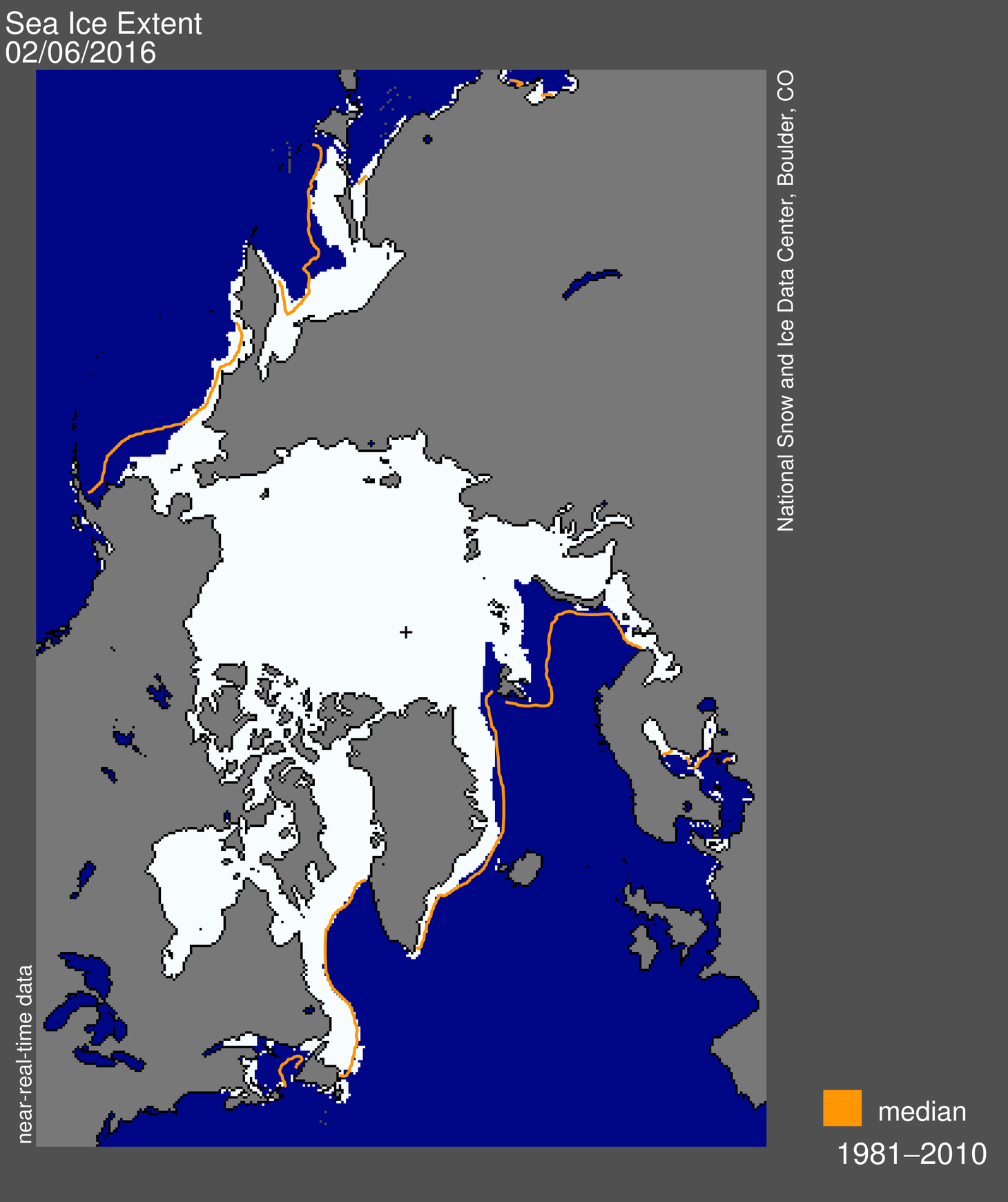
Sea ice is virtually absent from the Barents and Kara Seas, which constitute a large swath of the Atlantic Arctic, located northeast of Scandinavia and north of the Russian mainland.
“For the Arctic this is definitely the strangest winter I’ve ever seen,” said Mark Serreze, the director of the National Snow and Ice Data Center (NSIDC) in Boulder, Colorado, which tracks sea and land ice around the world.
[…]
Sea ice record during an “absurdly warm” month
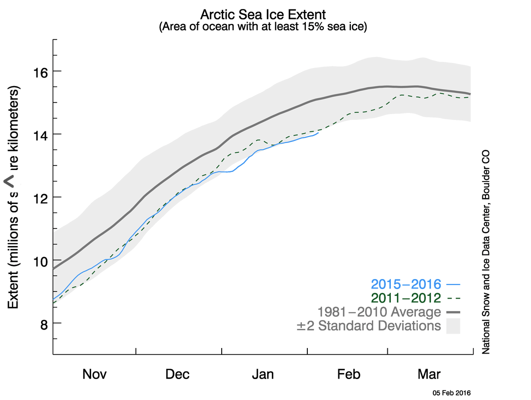
The milder than average conditions led January to have the lowest Arctic sea ice extent on record since the satellite era began in 1979, the NSIDC found.
According to an NSIDC report released Thursday, the monthly average sea ice extent for January was 42,500 square miles below the previous record low in 2011, and about 405,000 square miles below the 1979-2000 average.
For perspective, that departure from average is equivalent to missing a region of ice the size of the states of Texas, New Mexico, Maryland and New Hampshire combined.
The longterm trend for January sea ice extent is now a decline of 3.2% per decade, the NSIDC said.
Due to manmade global warming, sea ice has been in a near free-fall, while Arctic air temperatures have increased at twice the rate of the rest of the world due to a phenomenon known as Arctic amplification.
Arctic warming is having profound effects all around the region, from the loss of coastal villages and threats to iconic wildlife such as the polar bear and walrus. There is debate within the scientific community about whether Arctic warming is influencing weather patterns well beyond the Arctic, such as across the eastern U.S. and in Europe.
Blame the Arctic Oscillation?
The record low ice extent for the month had a lot to do with the way that weather patterns set up across the Arctic, Serreze told Mashable in an interview.
The entire Arctic was “just absurdly warm, I’ve never seen anything like that,” Serreze said.
Serreze pointed to a pattern of air pressure known as the Arctic Oscillation as a major driver of January’s Arctic warmth and low sea ice.
The Arctic Oscillation, or AO, is a pattern of air pressure differences between the Arctic and the midlatitudes. It swung into an extreme negative phase — meaning there were higher than average air pressure values over the Arctic and lower than average air pressure values over the mid-latitudes — during the first three weeks of January, dipping to near-historic lows.
The NSIDC provided a more zoomed-in view of January’s prevailing weather pattern across the Arctic, stating in a press release there was higher than average air pressure located from north central Siberia into the Barents and Kara sea regions, while lower than average air pressure dominated across the northern North Atlantic and northern North Pacific.
The airflow between and around these high and low pressure areas helped pump mild air into the Arctic, while interfering with the manufacturing of extremely cold air.
The result was as if someone had switched the northern hemisphere’s refrigerator onto a lower setting.
“The Arctic is behaving very oddly this winter,” Serreze said.
How the Arctic Oscillation, and the weather across the Arctic region in general, is interacting with a strong El Niño event in the tropical Pacific Ocean is still an open question, Serreze said
The El Niño is also helping to reconfigure weather patterns from Australia to the U.S. and beyond, but its relationship with the Arctic has only recently begun to be investigated.
“The question is how are these two things possibly conspiring there?” Serreze said.
He said even a late season burst of ice growth will put the sea ice cover in a vulnerable position going into the summer, since that new ice will be thin, and therefore more susceptible to melting.
“Things are not looking very good,” Serreze said of the warm winter and what it means for the upcoming melt season.