
Month: February 2016
“It was essentially a winter flash flood on a continental-scale river” — Robert Criss
From Science Daily:
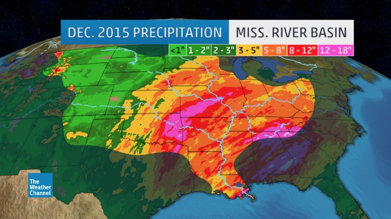
…only a day after the flood on the lower Meramec peaked, water levels on the Mississippi at St. Louis were the third-highest ever recorded. A few days later, record flood stages were recorded downstream at Cape Girardeau, Mo., and Thebes, Ill.
Why was the flooding so bad? Most news reports blamed it on the heavy rain, but Robert Criss, PhD, professor of earth and planetary sciences in Arts & Sciences at Washington University in St. Louis, said there was more to the flood than the rain.
“I think there was significant magnification of the flood levels on the Meramec by recent developments near the river,” he said. “Sure it rained a lot, but what happened here cannot be explained by the rainfall alone.”
The flood on the middle Mississippi River, in turn, was remarkable for its short duration and the time of year. “It was essentially a winter flash flood on a continental-scale river,” Criss said. “The Mississippi has been so channelized and leveed close to St. Louis that it now responds like a much smaller river.”
In the February issue of the Journal of Earth Science, Criss and visiting scholar Mingming Luo of the China University of Geosciences in Wuhan, China, take a close look at data for the New Year’s flood, treating it as a giant natural experiment that allowed them to test their understanding of changing river dynamics.
“Flooding is becoming more chaotic and unpredictable, more frequent and more severe,” Criss said. “Additional changes to this overbuilt river system will only aggravate flooding.
“In the meantime,” he said, “inaccurate Federal Emergency Management Agency flood frequencies based on the assumption that today’s river will behave as it has in the past greatly underestimate our real flood risk and lead to inappropriate development in floodways and floodplains.”

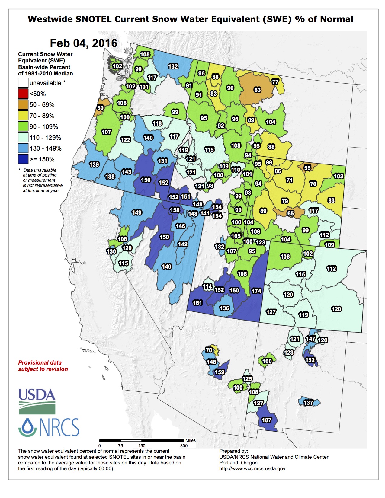
#Snowpack news: The Feb. 1 #Colorado Basin Outlook Report is hot off the presses from the NRCS
Click here to read the report. Here’s an excerpt:
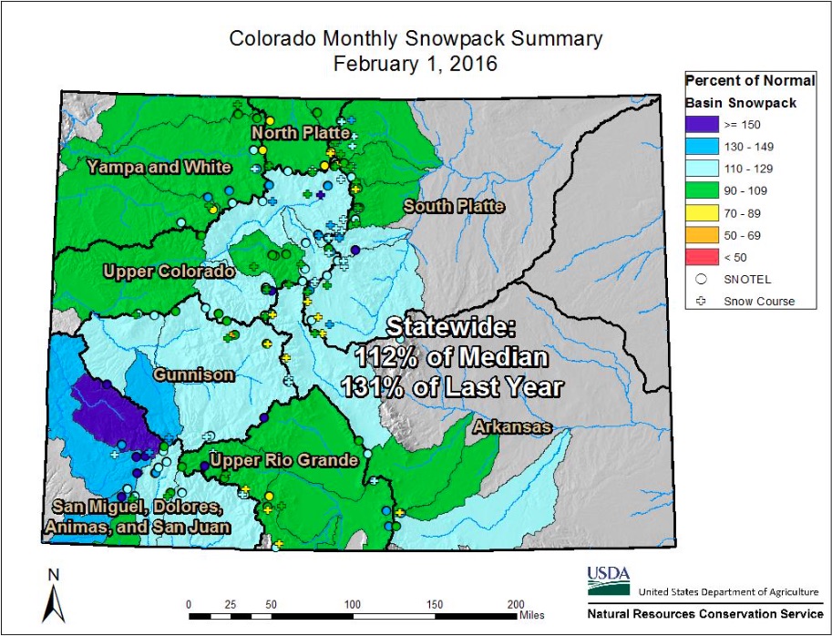
Colorado’s snowpack remains at above normal levels heading into February. A stream of moisture brought heavy snow to much of the state over the last few days of January, favorably amplifying the snowpack in all major river basins. Preceding this storm, many SNOTEL stations in the southwest basins and along the Continental Divide had received less than normal snowpack accumulations. However, the latest storm produced between 1 and 4 inches of SWE for the majority of Colorado’s SNOTEL sites. Although there are a few individual mountain locations that maintain a snowpack that is below the median, all of Colorado’s major river basins are at above normal levels. The combined San Juan, Dolores, Animas, and San Juan River basin holds the greatest snowpack, with respect to normal, at 122 percent of median, in part due to the bountiful snowpack in the San Miguel River basin, which is the highest in the state at 150 percent of median. This is in stark contrast to last year at this time when the combined southwest basins’ snowpack only amounted to 66 percent of the median. The combined Yampa, White, and North Platte basin ranks lowest among the major river basins, but is still above normal with a snowpack at 103 percent of median. Although there is a substantial portion of the winter still ahead, most of Colorado’s basins are currently on track to have a healthy snow accumulation season.
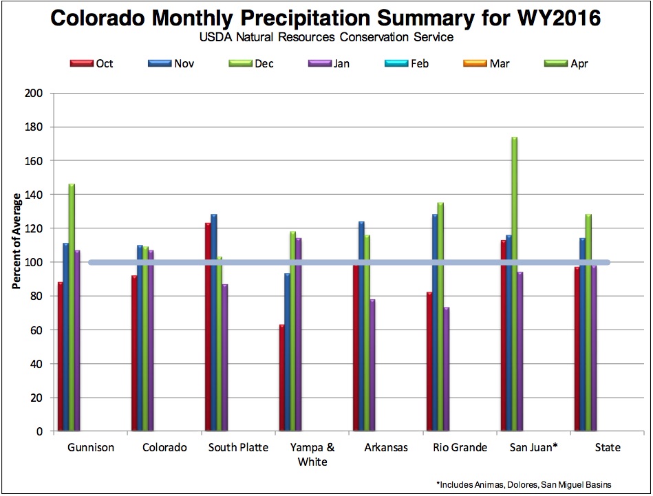
Thanks to a storm that impacted Colorado over the last few days of January, statewide mountain precipitation for the water year remains above normal. As of February 1st, water year-to-date precipitation (WYTD) for Colorado is at 109 percent of average. January precipitation was divided among the major river basins in Colorado; basins east of the Continental Divide generally received less than average precipitation while basins west of the divide received near or above average accumulations. The Rio Grande River basin had the lowest January precipitation relative to average at 73 percent. The Arkansas and South Platte basins were also below average at 78 and 87 percent respectively. However, this lack of precipitation was not enough to diminish the benefits from the wet December that these basins experienced, and all still have above average WYTD precipitation. The combined Yampa, White, North Platte River basin experienced the greatest January precipitation with respect to normal and received 114 percent of its average monthly levels. This boosted the basin’s WYTD precipitation to 99 percent of average. The Gunnison and Colorado River basins also saw above average January precipitation each at 107 percent and the combined San Miguel, Dolores, Animas, San Juan River basin was slightly below normal at 94 percent of average. Each of these river basins also have WYTD precipitation that is well above average, continuing the positive precipitation trends for Colorado.
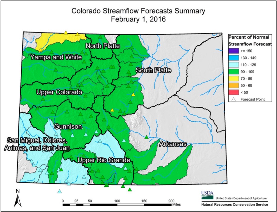
February 1st seasonal streamflow forecasts for most major basins in Colorado are predicting near to above normal volumes. Forecasts for rivers flowing from the San Juan Mountains of southwest Colorado are consistently the highest forecasts in the state. Vallecito Reservoir inflow has the smallest forecast in the region at 108 percent of normal and Gurley Reservoir inflow has the highest, at 122 percent. The Upper Rio Grande, also in southwest Colorado, follows close behind and has no points forecast to have below normal streamflow volumes with the highest being Saguache Creek near Saguache at 116 percent. The rest of the major basins in the state have forecasts surrounding, but generally near, normal values with a slightly decreasing trend from south to north throughout the state. The lowest percent of normal streamflow forecasts are currently on the Little Snake River, a major tributary to the Yampa that flows in northwest Colorado, but has much of its snow accumulating headwaters in Wyoming. Forecasts on the Little Snake range from 80 to 87 percent of normal. This general south to north decreasing trend also follows the snowpack accumulation trend, which is commonly observed during strong El Nino cycles, such as the one which has been experienced so far this winter.
#AnimasRiver: #GoldKingMine spill 6 months later — The Durango Herald
![This image was taken during the peak outflow from the Gold King Mine spill at 10:57 a.m. Aug. 5. The waste-rock dump can be seen eroding on the right. Federal investigators placed blame for the blowout squarely on engineering errors made by the Environmental Protection Agency’s-contracted company in a 132-page report released Thursday [October 22, 2015]](https://coyotegulch.blog/wp-content/uploads/2015/10/goldkingminespill1057am08052015viaepa.png)
From The Durango Herald:
On Aug. 5, 2015, contractors for the Environmental Protection Agency accidentally released 3 million gallons of contaminated wastewater into Cement Creek, a tributary of the Animas River. Six months later, questions about the effects of spring runoff, Superfund status and remediation remain unanswered.
Coyote Gulch has been reporting since August 5. Here’s the link to the Animas River category. Take a little scroll back in time.
Dolores River: Water Protection Work Group formed to protect ag and muni interests

From the Cortez Journal (Jim Mimiaga):
The newly formed Water Protection Work Group was created in response to a proposed National Conservation Area for the lower Dolores River.
The WPWG seeks to protect municipal and agricultural water supplies in Montezuma and Dolores counties from any consequence arising from NCA legislation.
Participants include Phyllis Snyder, Larry Don Suckla, Zane Odell, Doug Stowe, Greg Black, Don Schwindt, Drew Gordanier, Bernard Karwick, Bob Bragg, Keenan Ertel and Gerald Koppenhafer.
The recently released their minimum requirements and recommendations to David Robbins, a Colorado water attorney who has reviewed the NCA proposal.
“Prior public promises that the NCA ‘is not about taking water’ are appreciated and allow us to move forward with some assurance,” the group states in a memo. “Ambiguity and conflicting provisions must be left out of the NCA draft legislation.”
Some of the recommendations include:
The group wants the preamble of the NCA to be more specific about the Dolores River’s importance as the region’s sole water supply.
A proposed advisory committee in the draft NCA legislation requires more thorough definition.
The draft NCA bill must be written to explicitly prohibit any federal express or implied water rights on the Dolores River.
The draft NCA bill must release the Dolores River, upstream from the confluence with the San Miguel River, from consideration under the Wild and Scenic River’s Act. The recommendation also stipulates that no wild and scenic river portions below the San Miguel confluence can reach upstream water rights.
The NCA shall not affect the Dolores Project or the operation of McPhee Reservoir in any way.
The draft NCA bill has language prohibiting the building of large scale water projects. The WPWG recommends that large scale water projects be defined to exclude all existing projects, diversion, structures and water rights. Also, they recommend that the proposed NCA must not impact future projects under Colorado state water law that do not exceed 50,000 acre feet of annual use.
The group also wants written into any NCA legislation that management plans will not impact or influence releases or spills from McPhee dam, the water upstream from McPhee Dam, or the Dolores Project.
In April 2015, a legislative subcommittee of the Lower Dolores Plan Working Group released a draft bill that would designated a portion of the river an NCA and another portion a wilderness area.
In exchange, the river’s suitability status for a wild and scenic river below McPhee dam would be dropped.
The proposed Dolores River National Conservation Area would stretch from below the dam at Bradfield Bridge to Bedrock, Colo., and include the river and public land on both sides.
The draft bill also proposes to designate the Dolores Canyon Wilderness Area, a 30,119-acre swath of remote canyonlands that has been managed as a BLM wilderness study area for decades.
According to the draft, the Wilderness Area boundary would be located at the edge of the river, and no portion of the Dolores River will be included in it.
However, the draft bill shows the Dolores river would be part of the NCA, including where it runs through the wilderness area.

#Snowpack news: This week’s storm = 37 inches of powder at Aspen’s ski areas
From The Greeley Tribune (Nikki Work):
A snowy week across the state added to Colorado’s already positive snowpack numbers, according to the Natural Resources Conservation Service.
The whole state is above the historic average for snowpack, and the river basins that impact Weld County — the South Platte and the Upper Colorado — are both more than 10 percent above normal. These levels impact what the summer water supply will look like for the area, according to Brian Werner of the Northern Colorado Water Conservancy District.
As of Thursday, the South Platte River Basin was 12 percent above the historic average, and the Upper Colorado River Basin was 15 percent above average.
Reservoir storage numbers are up as well, with nearly every basin in the state above average as of Feb. 1. Werner said it’s important to use both snowpack and reservoir numbers to examine future water supply, because once the weather warms up in the spring and summer, and the snowpack melts, the pressure will fall on the reservoirs.
The South Platte River Basin is up 5 percent, and the Upper Colorado River Basin is up 9 percent. As a whole, the state is up 10 percent.
For the southern part of the state, which has suffered from drought for several years, these numbers are cause for hope. Werner said at a recent water meeting, he saw water officials from the southeast and southwest counties smiling for the first time in a while.
However, Werner said it’s too early to get comfortable, because while the averages are up in comparison to previous years, the most important months for snowpack are March and April, because that’s when the wettest snows of the year come. Werner said he’s seen winters where the snowpack numbers have been up early in the winter, but a dry spring has derailed hopes of a good water year.
In order to see one of those, we’ll need to see more snow, he said.
Though it’s too early to get cozy, Werner said he anticipates a good water year for farmers and ranchers, who have been sitting mostly pretty since the massive drought in 2012. If the snowpack and reservoir numbers stay on track, farmers shouldn’t have to worry about water supply restricting their acreage, he said.
From The Aspen Times (Scott Condon):
The storm that dumped 37 inches of snow on the slopes of Aspen’s ski areas Saturday into Tuesday was the 10th largest storm cycle in 37 years, according to Aspen Skiing Co.’s records. Skico Vice President of Operations Rich Burkley said the last big storm cycle was February 2014.
The storm did wonders for Aspen’s snowpack. It was at 100 percent of normal going into the weekend at an automated measuring station near the headwaters of the Roaring Fork River, according to the U.S. Natural Resources Conservation Service. It now stands at 115 percent of average.
In a recent posting on the Colorado Avalanche Information Center, Aspen zone forecaster Blase Reardon noted that 20 percent of the snowpack that has accumulated so far this season fell during the most recent storm. The avalanche danger spiked with one-fifth of the snowpack accumulating in just 72 hours.
Closer to Aspen, the storm on the last day of January boosted total snowfall for the month well above average, according to weather observer Laura Taylor at the Aspen Water Treatment Plant. She reported that 11 inches of snow fell Jan. 31. For the month, the water plant received nearly 35 inches of snow. The average is 26 inches. Only 5.26 inches of snow fell in January 2015, according to the water department’s records.
The Natural Resources Conservation Service reported that every major river basin in the Colorado mountains is running well ahead of last year’s snowpack levels. The Colorado River basin, which includes the Roaring Fork drainage, is 116 percent of last year’s snowpack as of Feb. 1. River basins in southwestern Colorado are 185 percent of last year’s snowpack.
Plans to rebuild U.S. 34 still a work in progress — Estes Park Trail-Gazette

From the Estes Park Trail-Gazette (David Persons):
In spite of what has been reported recently about the work which will likely start in late spring or early summer and last for two years or more, CDOT officials say there are just too many moving parts to say with any certainty just how long the $129 million project will take and how it will impact area residents and businesses.
“We honestly do not know a lot of these answers as the team is working to determine a lot of these variables,” said Jared Fiel, CDOT’s Communication Manager for Region 4. “The big thing to realize is that we have extensive outreach planned for the entire corridor in advance of any of the work starting.
“We will be having public meetings with both residents and businesses as well as a telephone town hall format for users of the corridor such as part-time residents, commuters, etc.”
When asked about the two-year construction time frame, Fiel said it will probably be two years.
“We are working at determining the actual scope and extent of the work to be done,” Fiel said. “Some of our early estimates for some aspects of the job proved to be too low, mainly based on logistics, meaning (as an example) if we are blasting rock in one place, we need to have a location on the corridor that needs that aggregate so we don’t have to pay more to have it shipped out, only to be brought back in later.”
Some have reported that the project will be done in stages.
“Again, probably,” Fiel said. “With the size and extent of this work, we will probably need to do different stages. How those stages (or construction packages) work, when they will happen, and if there will be overlap, are all to be determined.”
[…]
One thing that will almost definitely occur is the rerouting of Front Range (Fort Collins and Loveland) traffic to U.S. Highway 36 in Lyons as the major route to Estes Park, adding an extra half-hour of driving time.
“When construction begins in earnest, that is probably going to be a good idea,” Fiel said. “We will have detours available when (and if) we need to do any road or lane closures. We will also communicate this far in advance of any work going on.”
The section of U.S. 34 from Loveland to Estes Park, that winds through the narrows of the Big Thompson Canyon and past several smaller communities like Drake, was heavily damaged by the September 2013 flood event.
During the flooding, watershed runoff combined with flows released from Lake Estes Dam, and surges from debris dam breaches, produced huge flow surges that exceeded a 500-year flood event. As a result, the canyon section sustained widespread, massive damage.
Major sections of roadway were washed away completely, along with access bridges and retaining walls. In the narrows, much of the roadway and grade were undermined, washing out the pavement from below and exposing the wall support structures.
Temporary repairs were completed and the highway was reopened to traffic in both directions on Thursday, November 11, 2013. CDOT and its contractors worked from both the east and west ends of the canyon to assess and repair the damage and restore local access as quickly as possible. Emergency repairs were extensive and included removing debris, re-establishing shoulders and embankments, replacing damaged asphalt, filling washed out sections with concrete fill, repairing local access structures, and repairing damaged drainage structures.
After a couple years of doing research and design work, CDOT is ramping up for the permanent repair and/or rebuilt of U.S. 34. CDOT has named Kiewit Infrastructure Co. to serve as the Construction Manager/General Contractor (CM/GC) for this project.
Permanent repairs will include removing and replacing much of the temporary asphalt, embankment fill, and temporary channel protection; as well as re-vegetating, replacing guardrails, and repairing fencing. Some of the roadway sections that were not destroyed, but experienced flood water overtopping the roadway, will be analyzed and possibly replaced, according to information on CDOT’s website.
For more information about the project and updates, go online to http://www.codot.gov/projects/floodrelatedprojects/us-34-big-thompson-canyon-1.
Monument proposes steep increases to water bills — KOAA.com

From KOAA.com (Andy Koen):
Water bills will likely get more expensive in Monument this year. Under a proposed rate schedule, customers could end up paying nearly double what they did for water last year.
The largest increases will be applied to base rates. For residential customers, the base rate would increase nearly 5 fold from the current $8.80 per month to $40. Commercial customers would see their base rate grow some 789% from $9 per month $71.
The Town of Monument uses a tiered water rate structure that increases the price depending on the volume of water consumed. Rates would also be increased at each of the four tiers under the proposed schedule.
Factoring for water usage of between 3,000 and 6,000 gallons per month, the Town calculates a sample residential bill increasing from $28.76 per month to $46 in the winter. With a usage at 31,000 gallons per month, that same bill increases from $214.49 to $329.75 during the summer.
The worksheet also shows winter bills for commercial customers growing from $430.42 to $651.50 per month and from $805.95 to $1,267.25 in the summer.
The board is also proposing an additional 8 percent increase to the base rate every year through 2021.
Mayor Pro Tem Jeff Kaiser said previous Boards of Trustees kept water artificially low for too long.
“For the last 20 years, there has not been a water rate increase for a small subset of our population who are serviced by the town’s water district,” said Jeff Kaiser, Mayor Pro Tem.
He said the water enterprise has run deficits each year since 2012. Trustees have paid the bills by redirecting hundreds of thousands of dollars from the general fund. Kaiser said that is unfair to citizens who get water from other utilities such as Woodmoor Water and Sanitation and the Tri-View Metro District.
“Those citizens who are paying their fair share for the water, yet are being asked to in addition to that, subsidize 20 to 30 percent of our citizens such that they can enjoy extremely low water rates,” Kaiser said.
But business leaders warn the new rates are jumping too fast.
#Drought news: In #Colorado, reservoirs are averaging close to normal — US Drought Monitor

US Drought Monitor February 2, 2016

West Drought Monitor February 2, 2016

Colorado Drought Monitor February 2, 2016
Click here to go to the US Drought Monitor website. Here’s an excerpt:
Summary
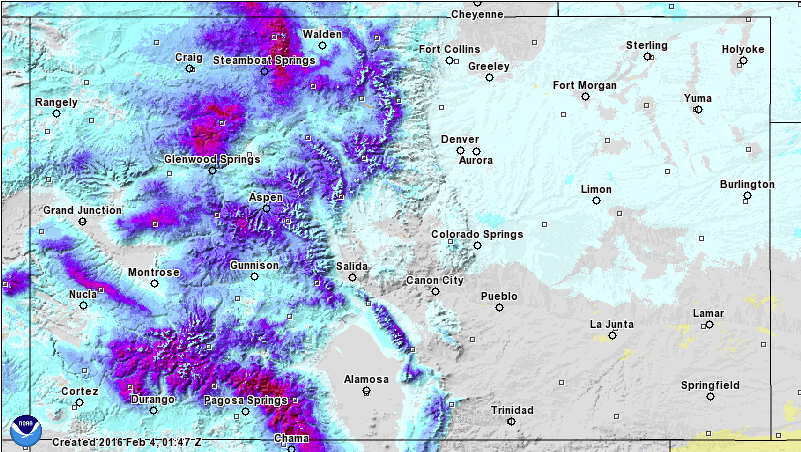
The week following the major East Coast snowstorm/blizzard was characterized by the passage of several cold fronts across the contiguous U.S., frequently changing temperature patterns related to deamplifying flow aloft, and widespread precipitation across the Great Lakes, the Southeast and the West. By the end of the observed period (Tuesday morning, 7am Eastern time), a major storm system had developed across the Southwest and was moving across the Central states, attended by areas of heavy snow (and in some cases, blizzard conditions), heavy rain, flash flooding, and severe weather…
The Far West
Western Washington, western Oregon, and approximately the northern half of California reported large precipitation surpluses during the past two weeks. The largest surpluses (4-8 inches or greater, liquid equivalent) were noted across the Olympic Peninsula of Washington, extreme southwestern Oregon, northwestern California, and in the northern Sierras. Viewed from a somewhat different perspective, AHPS Percent of Normal Precipitation (PNP) values ranged primarily between 150-300 percent of normal. In contrast, the coastal region of southern California had PNPs ranging between the 25th and 50th percentiles of the historical distribution.
Preliminary PARS data from the USDA (through January 30th) provides an informative look at reservoir conditions for the state of California. From about Sacramento northward to the Oregon border, PARS values generally range between 70-120 percent of average, though there are values that fall outside this range. Between Sacramento and Bakersfield, PARS values generally range between 20-70 percent of average, while south of Bakersfield, there are large variations between reservoirs, in addition to a relatively small sample size, making it difficult to approximate a useful range of values.
As of February 3rd, SNOTEL basin-average Snow Water Content (SWC) values in the California Sierras range from 110-150 percent of average. SWC values in northwestern Oregon range from 25-125 percent of average, and between 125-150 percent of average in the southwestern part of the state. In western Washington, SWC values range from 90-110 percent of average.
Despite heavy rainfall in January, an above-average snowpack and rising reservoirs in many areas, the California State Water Resources Control Board recently approved an 8-month extension of existing drought-related emergency regulations. This is a reminder that although El Nino-related precipitation has been bountiful so far this winter, the drought situation in California remains very serious.
It was decided to hold off on making substantial changes to the depiction in the far West until next week, despite heavy precipitation and rebounding stream flows in the short-term (past few weeks). This is because it takes time to assess the impacts all this moisture will have on long-term deficits and other hydrological considerations. The only change made this week was in the northern Sierras of California (El Dorado County), where the coverage of exceptional drought (D4) was reduced…
The Great Plains and Upper Mississippi Valley
For the few remaining areas of drought across the Plains and Upper Mississippi Valley, precipitation for the past two weeks has been generally close to, or slightly above, normal. In Texas, January 2016 precipitation was about 62 percent of normal statewide. Consideration of various 2-6 month precipitation indicators supported the introduction of D0 to Tom Green County in west-central Texas, and the introduction of D0 to Nueces and San Patricio Counties (along the southern coast near Corpus Christi). These same precipitation indicators, and the occurrence of fairly substantial evaporation, supported the expansion of pre-existing D0 conditions across Starr and Hidalgo Counties in far southern Texas. Decent precipitation fell in western Kansas prior to the data cutoff time (12z Tuesday) from a potent storm which brought a variety of weather hazards and precipitation types to the Central states. The amount of precipitation received thus far does not appear to be enough to eliminate the residual area of D0 in west-central Kansas, though it is enough to at least offset the dry pattern experienced during the last 30-days. In Nebraska and the Dakotas, the preliminary Percent of Average Reservoir Storage (PARS) data from the U.S. Department of Agriculture (USDA), as of January 31, 2016, shows values that generally range between 90-140 percent of average. In North Dakota, lack of snow cover, and 30-day and 60-day PNP ACIS (Applied Climate Information System) maps warranted a generous expansion of D0 conditions from its current location northward to the Canadian border (as far east as Rolette County), and as far west as the Missouri River. This is also consistent with neighboring dryness/drought across the border in southeastern Saskatchewan and southern Manitoba…
The Rockies and Intermountain region
During the last 14-days, northern and central portions of both the Rockies and Intermountain region experienced near- to above-normal precipitation amounts. Southern portions of both the Rockies and Intermountain region saw near- to below-normal precipitation amounts during the same observational period. PARS data indicates that reservoirs in Montana near the Continental Divide are generally running about 60-120 percent of average, and reservoirs across the High Plains of Montana are running about 105-150 percent of average. The only change to the depiction in Montana this week was to trim the severe drought (D2) area away from the Canadian border. This was based upon several considerations. The Standardized Precipitation Index (SPI) and the Standardized Precipitation Evapo-transpiration Index (SPEI) from 1-4 months, current stream flows running close to normal, and relatively wet conditions just north of the border in neighboring parts of Alberta and British Columbia. In Wyoming, PARS values range from about 95-175 percent of average, while in Colorado, reservoirs are averaging close to normal. Significant snowfall was reported in Colorado during the past few days (many areas received a foot or more of new snow). Reassessment of conditions next week will be needed to see if the removal of existing D0 areas in Colorado is warranted…
Looking Ahead
During February 4-8, 1-3 inches of precipitation is expected to fall across New England, New York, and the mid-Atlantic region, while 2-5 inches is forecast across parts of the Southeast. This should reduce, if not eliminate, some of the D0 coverage in this part of the country. For the northwestern quarter of the contiguous U.S., the mountainous areas can expect precipitation amounts (liquid equivalent) to range from about 0.5-1.5 inches, with perhaps as much as 4-6 inch amounts confined to the Olympic Peninsula and northern Cascades in Washington state.
During the ensuing 5 days (February 9-13), there are elevated odds of above-median precipitation from the Dakotas eastward across the Great Lakes to the northern Atlantic Coast, as well as for most of Alaska. Below-median precipitation is favored for most of the remainder of the contiguous U.S.
#Snowpack news: Last Minute Storms Stave Off Dry January — NRCS
Here’s the February 4, 2016 release from the Natural Resources Conservation Service (Brian Domonkos):
According to NOAA’s National Operational Hydrologic Remote Sensing Center (NOHRSC) nearly all of Colorado was covered in snow on February 3rd, thanks to two significant snow storms that graced Colorado near the first of the month. Statewide Colorado mountain snowpack on February 1st was 111 percent of normal, up from a January low of 105 percent on January 28th. “Without these two storms January precipitation totals would have only been near 70 percent normal, however as a result of these late January storms, statewide January precipitation closed out the month at 98 percent of normal and109 percent of the year-to-date total,” states Brian Domonkos, Colorado Snow Survey Supervisor with the USDA Natural Resources Conservation Service. Snowfall continued through February 3rd, which placed some extra icing on the cake and increased snowpack totals up to as high as 117 percent of normal on the morning of February 4th. The mountains of Southern Colorado saw the greatest increase in snow water equivalent, affecting the San Juans and Sangre De Cristos. From January 28th to February 3rd total snowpack depth increased as much as 30 inches at Cumbres Trestle SNOTEL in the San Juan Mountain range.

On February 1st snowpack in only a handful of minor watersheds across the entire state of Colorado were below the 100 percent mark, yet these were close to normal at above 90 percent. All other drainages were above to well above normal. While the late January storms benefitted the entire state, January precipitation as a whole was particularly slim in the Arkansas and Upper Rio Grande basins and storms only amounted to about 75 percent of normal monthly snowpack accumulation.

For more detailed information about individual Colorado watersheds or supporting water supply related information, have a look at the Colorado Water Supply Outlook Report or feel free to go to the Colorado Snow Survey website at:
http://www.nrcs.usda.gov/wps/portal/nrcs/main/co/snow/
Or contact Brian Domonkos, Colorado Snow Survey Supervisor at Brian.Domonkos@mt.usda.gov or 720-544-2852.
R.I.P. Maurice White

From NBC New York (David Bauder and Hillel Italie):
Earth, Wind & Fire founder Maurice White, whose horn-driven band sold more than 90 million albums and made hits like “September,” ”Shining Star” and “Boogie Wonderland,” died Wednesday at his home in Los Angeles, his brother Verdine said…
“My brother, hero and best friend Maurice White passed away peacefully last night in his sleep,” Verdine White, also a member of the band, told The Associated Press on Thursday.
#Snowpack news: Fresh snow over most of #Colorado

Statewide snowpack map February 3, 2016 via the NRCS.

Arkansas River Basin High/Low graph February 3, 2016 via the NRCS.

Upper Colorado River Basin High/Low graph February 3, 2016 via the NRCS.

Gunnison River Basin High/Low graph February 3, 2016 via the NRCS.

Laramie and North Platte Basin High/Low graph February 3, 2016 via the NRCS.

Upper Rio Grande River Basin High/Low graph February 3, 2016 via the NRCS.

San Miguel, Dolores, Animas, and San Juan Basin High/Low graph February 3, 2016 via the NRCS.

South Platte River Basin High/Low graph February 3, 2016 via the NRCS.

Yampa and White Basin High/Low graph February 3, 2016 via the NRCS.
From The Grand Junction Daily Sentinel (Dennis Webb):
Colorado’s snowpack was at 117 percent of average as of Tuesday, according to federal Natural Resources Conservation Service data. If coming months deliver even average snowfall, it will mean plentiful runoff reaching reservoirs this spring and abundant water this summer for Currier and others to use to irrigate fields.
If anything, the rest of the snow season should be above-average. Cory Gates, a meteorologist with aspenweather.net in Aspen and formerly a National Weather Service forecaster, said the El Niño weather pattern that has brought so much moisture so far this fall and winter probably will result in a normal February, followed almost certainly by a wet March and April.
“The rest of the winter is still going to be an El Niño-type winter. Even though it’s weakened out there, there’s plenty of characteristics of it still,” he said.
El Niño winters stem from warmer ocean temperatures in the eastern equatorial Pacific Ocean. This year’s El Niño is one of the strongest on record. From early on, it had forecasters predicting a wet start to the season’s snowfall, possibly a slowdown in snowfall in mid-winter, and then a wet March and April if the El Niño conditions held on that long.
Fortunately, even January remained above normal for local snowfall, Gates said.
The bountiful snowfall carried into the start of February this week, as everyone knows, from skiers enjoying powder days to students who reveled in rare school snow-day closures.
Gates said Aspen ski resorts got about 40 inches of snow in the last three days.
“The skiing is epic. I talk to a lot of people every day. It’s up to their waists and they’ve got on big powder skis and they’re having fun,” he said.
Snowpack Tuesday in the Upper Colorado River Basin was at 116 percent, and the Gunnison Basin was at 122 percent. Snowpack ranged from 102 percent in the Laramie/North Platte basins to 130 percent in the San Miguel, Dolores, Animas and San Juan basins. El Niño winters are usually particularly generous in terms of snowfall in southwest Colorado, and less so in northwestern Colorado.
According to a weekly update from the Colorado Climate Center at Colorado State University, which works with the National Integrated Drought Information System, “Western Colorado saw mostly above-average precipitation over the past month, generally more than 200 percent of normal. The San Luis Valley was a dry area though, with parts of Alamosa and Conejos counties down to 20 percent of normal.”
Statewide snowpack is actually down a bit from 121 percent as of Dec. 30. Levels in the Upper Colorado and Gunnison basins increased slightly during the last month.
Currier also is involved with Colorado water policy as a member of the state Interbasin Compact Committee. He said the state’s water picture looked bleak as recently as last April, before being boosted by strong spring snow and then a lot of rain in the summer.
“And then the start of the snowpack this year has been really good news,” he said.
An automated snowpack measurement at Park Reservoir on the Grand Mesa already shows 19 inches of snow water equivalent. That’s promising for irrigators, because usually if it peaks at around 23 to 25 inches for the winter, reservoirs on the mesa will fill, Currier said.
He’s less certain what might happen to water levels this year in Lake Powell, which states in the Upper Colorado River Basin rely on to meet water delivery obligations to downstream states. Currier said it all depends on what happens in March and April, which are crucial months for snowpack, and he noted that one Upper Basin state, Wyoming, has below-average snow.
“We’ve still got some catching up to do in the northern part of the Colorado River Basin to have as much as we’d like to have,” he said.
Gates’ confidence that a snowy March and April are coming leads him to believe that Lake Powell’s water level will go up “a lot” — probably between 40 and 47 feet, he said.

From The Pueblo Chieftain (Chris Woodka):
This week’s snow added to an already abundant snowpack in Colorado.
As of Wednesday, all areas of the state were above the median snowpack for the date, with most areas about 10,000 feet already above 60 percent of the average peak snowpack for the year, with some places above 75 percent or more. The peak usually is reached in April.
“All of our snow courses were at 100 percent of average at the end of the month,” said Rick Sexton, caretaker for Clear Creek Reservoir for the Pueblo Board of Water Works. “That was before the most recent snow.”
Pueblo Water keeps track of snow in the mountains as an indicator of how much water transmountain diversions likely will bring in through ditches and tunnels for the coming year.
Statewide, the snow water equivalent for the state was 117 percent of median, with both the Arkansas River and Rio Grande basins at 121 percent. The measurement is made by estimating how much moisture is in the snowpack, based on depth and temperature. In the Arkansas River watershed, the snow water equivalent ranges from 3-12 inches at Natural Resources Conservation Service stations.
Southern Colorado recorded more than a foot of snow in some places, including northern El Paso County and Colorado City. There were 3-14 inches in the Upper Arkansas Valley and 2-5 inches east of Pueblo. About 3-5 inches fell in Pueblo and Pueblo West. More snow or drizzle Wolf Creek Pass, as usual, is reporting the greatest snow depth in the state, with 86 inches at the NRCS station and the ski area reporting a midcourse depth of 102 inches.
Pueblo’s official precipitation for the year has reached 0.83 inches, which is more than twice the average.
The Fryingpan Arkansas Project is on track to bring in 67,800 acrefeet, well above normal, according to the Feb. 1 forecast by the Bureau of Reclamation. That usually changes as weather conditions fluctuate.
“It’s still early,” said Roy Vaughan, Fry-Ark manager for the Bureau of Reclamation. “We rely on the May 1 forecast.”
With reservoir levels above average, there could be issues with storing water in Lake Pueblo and other places this spring once the snow starts melting. Fry-Ark project water has first priority.
Climate models are predicting a strong El Nino (warming of the Pacific Ocean) will continue, meaning above average precipitation in Southern Colorado through this spring.
From TheDenverChannel.com (Marc Stewart):
“The average snow pack is about 120% of normal in the mountains right now, so we’re in really good shape, especially in early February,” said Denver7 Chief Meteorologist Mike Nelson.
According to Denver Water: Collection in the Upper South Platte watershed is 126% of normal and in the Upper Colorado River watershed it is 118% of normal…
The snow helps to keep the ground moist, so wildfires don’t spread. More water in the reservoirs can mean fewer restrictions when watering your lawn this summer.
The months ahead are encouraging.
Warm waters in the Pacific Ocean could lead to more snow and rain here in the Rockies in March and April – a phenomenon known as El Nino.
Still there is cautious optimism.
“It’s way too early to be cheering victory or saying that we’re already going to have a great summer of water supply We still have some big months ahead of us as water supply goes,” said [Travis Thompson].
From 9News.com (Maya Rodriguez):
Our recent winter storm in Colorado put the state back on track when it comes to snowpack levels in the mountains. The snow — which was measured in inches in the metro area, but in feet in the mountains — means Colorado’s snowpack rebounded after a slow January.
“Statewide, it was a huge factor,” said Brian Domonkos, Colorado Snow Survey Supervisor with the USDA/NRCS. “Without the storm, snow totals and precipitation totals for January were going to be in about the 70 percent of normal range.”
Now, though, statewide snowpack is up to about 118 percent of what it would normally be at this time of the year. What does that mean? For now, you can expect good skiing, and later on in the year, it could be good news for Colorado’s drinking water supply…
What happens in January and February, though, isn’t always an indicator of what might happen from March until May. Still, the influence of El Nino out in the Pacific, usually means there is the potential for more snow in Colorado. In the mountains, snowpack season is longer than the traditional winter start of Dec. 21. Snowpack season starts in October and runs through April, when the snow begins to melt.
“We’re, at this point, about two-thirds of the way through the typical snowpack accumulation season,” Domonkos said.
Historically, February is one of the winter months which sees that lowest snowpack accumulation, before it picks up again in March and April. That means, from here on out, every flake of snowfall counts.
#AnimasRiver: Durango sends letter to Colorado governor in support of Superfund — The Durango Herald

From The Durango Herald (Jessica Pace):
Mayor to meet Friday with Hickenlooper
As Silverton and San Juan County officials continue struggling with the terms of Superfund designation, Mayor Dean Brookie said the city of Durango sent a letter this week to Gov. John Hickenlooper supporting National Priorities Listing for a Silverton-area mining network, pointing to concerns about water quality for Durango residents.
“What Durango needs might be different from what Silverton needs,” Brookie said. “This is not to upstage Silverton in any way, but the 20,000 people on our water system, compared with the repairs needed on our water system, creates vulnerability for next summer. This is a way to make sure we have a safety net in the event of another spill.
“This is fairly urgent on our part, and independent of Silverton action.”
[…]
Last month, the La Plata County Board of Commissioners approved a resolution of support for Superfund designation. Commissioner Julie Westendorff has expressed in public meetings that she thinks La Plata County should take a supporting role to Silverton’s lead, though Commissioner Gwen Lachelt said she would support sending pro-Superfund communication to the governor ahead of Silverton.
However, all commissioners are unanimous in their support for Superfund.
Brookie said he will meet with the governor on Friday to discuss Durango’s needs.
Two water wells in Security shut down as precaution over chemical — The Denver Post

From The Denver Post (Kieran Nicholson):
Concerns over a chemical found in water wells in El Paso County have resulted in the shutdown of two wells as a precautionary measure.
The chemical known as PFOA has been detected in two wells in the Windmill Gulch aquifer.
Those wells have been voluntarily shut down, Security Water District manager Roy Heald said last month in a Fountain Valley News Facebook post.
In 2013, the U.S. Environmental Protection Agency detected PFOA in 94 public water systems in 27 states, including wells in Security, Widefield and Fountain.
The chemical, used in Teflon, can cause cancer, birth defects and heart disease, and weaken the immune system.
The Security wells in question pump water into a tank that “commingled” with water from the Fountain Valley Authority, diluting the Windmill Gulch water to safe, acceptable levels, Heald said in the post.
Still, the two wells have been “turned off indefinitely,” and Security will consult with the EPA on “how to move forward.”
The well in Fountain is a backup, used only in peak water use times, during summer months, said Fountain Utilities director Curtis Mitchell.
PFOA readings at that well have never exceeded EPA standards, Mitchell said Tuesday night.
Water from the Fountain well in question also commingles with other water — from the Pueblo Reservoir, the chief surface supply for Fountain — when it enters the system, Mitchell said.
Fountain will continue to monitor its water on a “voluntary” basis, Mitchell said. Fountain water recently met with the Colorado Department of Health and Environment to probe and discuss the situation.
At this time of year, Fountain doesn’t use well water…
Widefield average levels are .034 ppb, “which are well below” the maximum recommended level, the district said.
Fort Lyon Canal board postpones well augmentation dry up hearing
From The Pueblo Chieftain (Chris Woodka):
A hearing next week on a plan to dry up about 6,700 acres on the Fort Lyon Canal has been canceled because some shareholders have complained about potential conflicts of interest.
The Fort Lyon board made the decision Tuesday night after about 10 percent of the shareholders filed a petition alleging conflicts with the canal company’s attorney and engineer. The move cancels the Feb. 11-12 hearings that were planned in Las Animas.
The hearing is for Arkansas River Farms, which bought 14,600 acres of Fort Lyon farms for $53 million last year and announced plans to dry up some of the ground at the annual meeting in December. Fort Lyon shareholders agreed to a public hearing to resolve some issues before a change of use application is filed in water court.
John Lefferdink, the attorney for the Fort Lyon Canal Co., is related by marriage to Bill Grasmick, who is working with Karl Nyquist for Arkansas River Farms.
Duane Helton, the engineer for Arkansas River Farms, was the Fort Lyon Canal’s engineer for 35 years. Tom Williamsen, the canal’s engineer, was Helton’s partner before Helton went into business for himself.
“I didn’t feel there was a conflict of interest,” said Dale Mauch, a board member of the Fort Lyon Canal. “If anything, John (Lefferdink) would be even more conservative in dealing with this.”
But the Fort Lyon board has decided to seek an outside attorney and engineer because of the potential that any decision made by the shareholders at next week’s meeting would not stand in court, Mauch said.
“We felt like we didn’t have a choice,” Mauch said. “Why go through the proceedings if they are going to be challenged?”
The hearing could be rescheduled as soon as April, or as far off as July. The board does not want to schedule it in May or June, when farmers will be busiest in the fields.
Arkansas River Farms, an affiliate of C&A Companies and Resource Land Holdings wanted to move ahead with its plans to use water from the dried-up farms as part of wellaugmentation plans this year. The water would replace depletions from wells further downstream, and a plan has to be filed with the state engineer by March 1.
C&A is the parent company of GP Resources, which announced a plan in 2011 to pipe treated water from the Lamar Canal to the Front Range. That plan has been put on hold in favor of new plans for a large dairy in Prowers County.
The farms on the Fort Lyon Canal were purchased from Pure Cycle Corp., which bought them from High Plains A& M. Those companies once planned to move the water off the farms to Front Range communities.

Colorado lawmakers want to beef up state climate plan
Broomfield City Council approves $3.7 million wastewater facility expansion — Broomfield Enterprise

From The Broomfield Enterprise (Jennifer Rios):
Broomfield City Council gave the green light for the wastewater treatment facility to seek proposals for expansion to their laboratory and administrative office space.
Councilmembers unanimously passed six consent agenda items Tuesday night without discussion…
The Environmental Services Division in Public Works provides laboratory services to the Water and Wastewater Treatment facilities. The laboratories share staff, space and equipment between the two facilities to comply with all water and wastewater regulations in an efficient and cost effective manner.
“The laboratory at the water treatment facility, constructed in 1997, is adequately seized for the staff and work load,” a memo reads. “The laboratory at the wastewater treatment facility, constructed in 1987, has not been expanded to keep up with the additional staff and work lead increase over the last 28 years.”
The lab was built with work space for two staff member, and does not support the five employees and equipment added since 1987.
Burns & McDonnell, a Denver-based engineering firm, was retained in late 2014 to complete a study for the facility, east of Lowell Boulevard on West 124th Avenue, and determined the existing space was about half of the size that is typical for the staffing and testing performed at the facility.
Construction costs are estimated between $3.7 million to $3.8 million, according to a city memo. That amount is included in the 2016 budget.
Colorado Foundation for Water Education events
I’ve been remiss in posting links to the events below from the Colorado Foundation for
Water Education. Here goes:
February 12: Water Fluency Spring 2016
A professional development course to help you understand water and lead with confidence
Course curriculum focuses on:
Colorado’s water resources: the role of water in society, the economic value of water, ties to public policy, emerging issues Legal and institutional frameworks: water law and administration, project planning and approval, interbasin projects and agreements Water resource management: watershed health, environmental protection, water quality, natural disasters Colorado water for the future: assessing supply and meeting demand, ecosystem values, conservation and land use, alignment of resources and policies This unique educational experience will increase your water fluency so you can better analyze water’s influence on the issues you deal with everyday and evaluate creative solutions. Become immersed in the language and concepts of water as well as tools for navigating the culture, complexity and future of water management and policy issues. You will leave equipped with relevant knowledge and a new network of peers to create lasting, positive change in your community. If you’re an elected official, a professional interested in water or a community or business leader, this program is for you!
Registration is now open for Water Fluency Spring 2016: Northern Front Range
Register here by February 12. A limited number of partial scholarships are available. Members of the Special District Association may be eligible for a 75 percent scholarship, while some 50 percent scholarships are also available thanks to local program sponsors. Water Fluency scholarships are competitive. You can apply for a scholarship after you have completed your registration. Scholarship applicants will be notified by 2/12.
Participants learn through site visits; four half-day in-person classroom discussions; and online material, presented in partnership with Colorado State University’s online water course, with an estimated total time commitment of 30 hours over 10 weeks.
Attendance is required at in-person sessions and will be held during the afternoon on the following dates and locations:
March 2, Greeley
March 23, Fort Collins
April 19, Berthoud
May 10, Longmont

February 26: Water for Commodity Production Tour
On February 26, 2016 spend the day with CFWE on our Water for Commodity Production Tour. We’ll explore the relationship between water demands, public policy and economic development, and see innovative approaches in the Pueblo area. Hear about land use policy and planning for economic development, economic return and distribution scale of local agricultural products, industrial hemp and commercial marijuana operations, leasing water for industrial water uses, gain some historical and current context of water for steel production and much more.
Review the draft itinerary here. Seats are limited and expected to sell out…Register here.
March 11: Climate & Colorado’s Water Future
Join us on Friday March 11, 2016 for CFWE’s annual Climate and Colorado’s Water Future Workshop! This year we’ll meet in Boulder to tour INSTAAR’s Stable Isotope Lab and hear from many local experts to learn about Colorado’s crazy climate. Hear and see how researchers use ice cores to understand the composition and temperature of Earth’s atmosphere; explore drought, climate change, the water cycle and ecosystem; find out how changes in climate can alter hydrology and how water managers are preparing and planning for an uncertain future. We’ll come away with new tools to better teach and communicate about climate. View the draft agenda and register here—this annual offering always fills. Reserve your space today!
* 0.5 credit hour is available through the Colorado School of Mines Office of Continuing Education to teachers requiring graduate-level relicensure hours. Teachers seeking credit must bring a $35 tuition check (in addition to paying the course registration fee) made payable to “CSM Continuing Education” the day of the workshop. Please contact caitlin@yourwatercolorado.org if seeking continuing education credit or with any questions.
Colorado Leopold Conservation Award® Program Seeks Nominees

Here’s the release from the Colorado Cattleman’s Association (Paula Waggoner):
Applications are now being accepted for the prestigious Leopold Conservation Award® honoring agricultural landowners in Colorado who demonstrate outstanding stewardship and management of natural resources.
Given in honor of renowned conservationist Aldo Leopold, the $10,000 award recognizes private landowner achievement in voluntary conservation. It is presented annually by Sand County Foundation, the Colorado Cattlemen’s Association, the Colorado Cattlemen’s Agricultural Land Trust, Tri-State Generation and Transmission Association and American AgCredit.
Applications are due by March 8, 2016. Finalists and recipient will be announced by April. For complete application information, visit http://www.leopoldconservationaward.org.
In his influential 1949 book, A Sand County Almanac, Aldo Leopold called for an ethical relationship between people and the land they own and manage, which he called “an evolutionary possibility and an ecological necessity.”
“The outstanding agricultural landowners we honor with the Leopold Conservation Award exemplify what it means to be leaders in conservation for the benefit of our environment,” said Kevin McAleese, Sand County Foundation President.
“Ranchers are the original environmentalists. The Leopold Conservation Award recognizes a long history of caring for the land, while rewarding ranchers who are excelling in their holistic approach of stewardship,” says Bob Patterson President of the Colorado Cattlemen’s Association.
Award applicants are judged based on their demonstration of improved resource conditions, innovation, long-term commitment to stewardship, sustained economic viability, community and civic leadership, and multiple use benefits.
The Colorado award is sponsored by Tri-State Generation and Transmission Assoc., American AgCredit, DuPont Pioneer, The Mosaic Company and the Natural Resources Conservation Service.
Weekly Climate, Water and Drought Assessment of the Upper #ColoradoRiver Basin
Click here to read the current assessment. Click here to go to the NIDIS website hosted by the Colorado Climate Center.
Above normal #snowpack in some of last winter’s driest regions — High Country News
From The High Country News (Paige Blankenbuehler):
At the beginning of February last year, South Lake Tahoe in California was nearly 60 degrees Fahrenheit, almost 20 degrees above its historic average. At that time, the drought had been dragging along for four years and chair lifts at nearby ski resorts were swaying over barren slopes. Representatives from the California Department of Water Resources called the Sierra Nevada snowpack “dismally meager,” at only 23 percent of normal.
Now, it’s a drastically different story. January has been California’s best month for snowpack since 2011, and the state’s measurements are at 127 percent of normal. Although California’s snowpack is above normal this year, it’s still not enough to make up the deficit from the persisting drought in the state. It is enough, though, to keep ski resorts running and reservoirs in the state from drying up.
Above normal snowpack measurements are tracking for most of the West, too. The season was off to a slow start with sporadic storms October through December, but January winter precipitation increased measurements across all states, according to the Natural Resources Conservation Service’s SNOTEL sites, which measure snow depth at thousands of stations nation-wide. Utah claimed the biggest increase from early season snowpack, from 84 percent to 118 percent snowpack readings on February 1. Over the past month, California snowpack increased from 90 to 127 percent, and Arizona jumped from 83 percent to 113 percent of normal.
Only two Western states, Montana and Wyoming, are below the historic benchmark for “normal” at this time of year — and not by much. North-central Wyoming and the eastern slope of the Northern Rockies in Montana are the low-snow areas. Both states are more than 80 percent of normal for this time of year, and February is a crucial month for snow. Snowpack typically builds until April, says Alan Haynes, a hydrologist for the California Nevada River Forecast Center.
But even states with snowpack measurements lagging behind, readings from early in the season have improved. Since December, snow depth in Montana has hobbled to 84 percent of normal — from 73 percent in early December. And Wyoming similarly increased to 84 percent, from about 75.
Measurements from SNOTEL sites across the West, which have been recording precipitation and snow depth this season since Oct. 1, 2015, are painting a reverse picture of last year. Areas that were far below average last year — the Tahoe Basin in California and the Cascades in the Pacific Northwest — are recording the highest precipitation in the West so far this season.
The most precipitation has fallen in Washington and Oregon. In terms of percent of normal snowpack, Nevada has been leading the region with nearly 140 percent of normal readings across the state, according to data compiled by NRCS.
In California, local forecasters say the past few months are finally chipping away at the state’s five-year drought. The deficit will be hard to overcome, Haynes says, but if this season continues, the state might avoid fallowing fields. California gets 30 percent of its total water supply from snowpack, and reservoirs that have been low are now slowly filling up. Shasta Reservoir, one of the largest storage systems in the state is currently more than 50 percent full, or about 75 percent of the historical average for this time. “If we get shut out for the rest of the winter, the outlook could be bleak,” Haynes says.
Winter recreation in California is also benefitting from the abundant snow. The Hagens Meadow SNOTEL site near South Lake Tahoe is reporting 53 inches of snow depth, or 158 percent of normal, and Ostrander Lake site, in south Yosemite National Park, has had 220 inches of snow…
While El Niño may be creating a more robust winter storm pattern, it’s difficult to attribute all of the heavy snow to the global weather phenomenon. “This year has been a really strong El Niño, but we’re seeing snowfall patterns that are somewhat unusual for this weather event,” Haynes says. The Northwest, which would typically be fairly dry, is wet. And precipitation in south-central California hasn’t lived up to early El Niño predictions for that part of the state. The U.S. Drought Monitor remains cautiously optimistic about recovery. According to the center’s January 28 report, “the trend is going in the right direction for now with a good chunk of the snow season still left to play out over the next two months.”
From The Kearney Hub (Lori Potter):
“Everything is just in good shape,” Civil engineer Cory Steinke said in his report Monday to the Central Nebraska Public Power and Irrigation District Board of Directors.
Lake McConaughy, which stores water for CNPPID irrigation, hydropower, wildlife habitat and recreation, and for other water interests, is 83.5 percent of a full volume at 1,457,000 acre-feet.
Steinke said North Platte River inflows at Lewellen have been around 1,200 cubic feet per second, and the South Platte is “roaring pretty good” at 1,200-1,400 cfs at the Colorado-Nebraska state line. Releases from Lake McConaughy were at 900 cfs Monday.He said South Platte water is running through CNPPID hydros and is the main factor in overall flows exceeding current Central Platte River targets set by the U.S. Fish and Wildlife Service for wildlife habitat. Steinke expects diversions into the Phelps Canal for seepage into groundwater that eventually reaches the river can continue until at least Feb. 15.
Meanwhile, mountain snowpacks that produce the Platte River’s headwaters continue to grow. Steinke said that in the North Platte Basin, the upper area’s snowpack is at 98 percent of normal for Feb. 1, and the lower basin is at 106 percent. The South Platte Basin is at 105 percent.
Arkansas Valley Farm/Ranch/Water Symposium and Trade Show to focus on hemp, water, more
From The Pueblo Chieftain:
An update on a 15-year study of water tables, salinity and selenium in the Lower Arkansas Valley will be shared Feb. 11 at the annual Arkansas Valley Farm/Ranch/ Water Symposium and Trade Show.
There will also be information on farming trends, techniques and new crops such as hemp.The event will be from 8 a.m. to 4 p.m. Feb. 11 at the William L. Gobin Community Building, 105 N. Main St., Rocky Ford.
Tim Gates, a civil engineering professor at Colorado State University- Fort Collins will speak about Arkansas River return flows from ditches at the meeting. Gates and his team have found that better irrigation practices could reduce the amount of salinity and selenium in the Arkansas River, as well as eliminating waterlogging, or high groundwater tables.
Also in the lineup for the meeting will be Chuck Hanagan, with the federal Farm Services Agency; Brian Bledsoe, KKTV 11 chief meteorologist; James Robb, director of the Livestock Marketing Information Center; Kathy Voss, consultant for Livestock for Landscapes; Troy Bauder of Colorado State University Extension Service, on conservation tillage; and Joel Lundquist, a farmer and custom harvester, on new opportunities for growing hemp.
Reservations are $20 per person, $30 per couple and $5 per student in advance; $25 per person, $35 per couple and $5 per student at the door. Payment and contact information may be sent to P.O. Box 190, Rocky Ford, CO 81067.
For information, call 791-254-7608.

Gore Creek cleanup plan nears approval — The Vail Daily
From The Vail Daily (Scott N. Miller):
State officials in 2012 placed Gore Creek — as well as a number of other mountain-town streams — on a list of ecologically impaired waterways in Colorado, but that doesn’t mean the creek is the equivalent of a Rust Belt river that can catch fire. Still, humans have affected Gore Creek’s aquatic life — particularly bugs that are the food supply for fish.
To help repair that damage, town officials have been working for some time on a plan called Restore the Gore. The plan’s design so far has included working with consultants, the Eagle River Water & Sanitation District and residents. The plan has also been the subject of six hearings at the Vail Planning and Environmental Commission. The Vail Town Council is the final step to putting the plan — and its 217 recommended actions — into place. Council members Tuesday took a close look at the plan, with an eye toward final approval at the board’s March 15 evening meeting.
MINIMIZING POLLUTANTS
The plan in its current form has a good bit of regulation in it — including what people can spray on weeds they’re legally obligated to control.
But a majority of the recommendations fall into two categories: specific projects and management practices.
The identified projects cover nearly the length of Gore Creek, from the Interstate 70 runaway truck ramp nearest to town to the parking lots at the town’s two supermarkets. The projects run the gamut from restoring creekside vegetation to creating an artificial wetland area — a natural pollutant filter — to catch cinders falling off of I-70 to working to treat runoff from supermarket parking lots.
Gary Brooks, an engineer who is part of the town’s consultant team, said the idea behind all of the projects is to either dilute or interrupt pollutants that would otherwise make their way into the stream.
EDUCATION IS KEY
Education and management practices are similarly broad. Vail Environmental Sustainability Director Kristen Bertuglia said education is a significant part of virtually every element of the plan, from helping homeowners to teaching the landscaping companies those property owners hire.
Those educational efforts seem to be well-received so far. Bertuglia said an informational meeting for landscaping companies in 2015 drew between 80 and 100 people, most of whom were company owners.
Landscape companies that take a sustainable landscaping class — organized in cooperation with the Betty Ford Alpine Gardens and scheduled for the spring of this year — can earn a creek-friendly certification from the town. Those companies can use that certification in their own efforts to line up clients for the coming season.
And residents in general seem interested in learning more, Bertuglia said.
“I’ve been inspired by how the community has gotten behind this effort,” Bertuglia said.
VAIL RESORTS INVOLVEMENT
Responding to a question about Vail Resorts’ involvement in the plan, Bertuglia said the environmental team from the company has been involved in drafting the plan, and this winter has moved one of its major snow piles on the valley floor so it will have less impact on the creek when the pile melts.
PRICE TAG FOR PROJECTS
All of these efforts will cost money, of course. Just one project — the stormwater treatment project at the I-70 truck ramp — has an estimated price tag of more than $150,000. Better treatment of runoff from the supermarket parking lots will certain cost more. Another project, a 2017 redo of Slifer Plaza, carries an estimated price of more than $1.3 million, much of which will be spent on replacing an aging storm sewer that runs from north of the Vail Village parking structure into the creek.
The best use of taxpayer money will be a key element of the plan.

Gore Creek

Kayaking Gore Creek via Vail Recreation

Gore Creek through Vail golf course summer 2002

Big snows coated the Gore Range in March 2014. bberwyn photo.
#COWaterPlan: Colorado Cattlemen’s’ Association Mid-Winter Conference recap

From the Colorado Cattleman’s Association via the High Plains/Midwest Ag Journal:
Members of the Colorado Cattlemen’s’ Association gather twice a year to gain knowledge about their industry, create policy that drives their trade association and present awards to those who have served the state’s beef industry in an exemplary fashion.
[Last] week’s Mid-Winter Conference, held in Denver, focused on the agriculturally-related issues that will be addressed during the 2016 session of Colorado’s General Assembly. In addition, committee meetings were held that help to establish the organization’s policies and stance on a wide range of legislative and regulatory topics that will be impacting the beef industry in Colorado. Topics ranged from the Colorado Water Plan and state lands grazing fees to federal lands management and the Endangered Species Act. “Members gathering to discuss issues and reach consensus on a course of action is the purpose of the organization,” says Bob Patterson, president of Colorado Cattlemen’s Association. “This is the time when members have a chance to gather facts and engage in the policy development process that drives our organization.”
CCA Foundation Banquet
On the evening of Jan. 19 during the Colorado Cattlemen’s Foundation Banquet, awards were presented to individuals who have made a significant impact on the industry.
Awards presented by Colorado CattleWomen, Inc.:
Cattle Woman of the Year
Cattle Woman of the Year, Nancy Carlson, has been a very active member of the Black Mesa CattleWomen for five years. Through her engagement with the Western Slope CattleWomen Council, she discovered the need for good educational material for the general public. She began developing material, which is a talent that came naturally because of her background as an educator. As a result, she wrote a book, has served as the Colorado CattleWomen’s education chairman and is currently serving as the working group manager for the youth development K-12 group for the American National CattleWomen.
Rookie of the Year
Kacie Burns of Paonia was selected as Rookie of the Year. Even while attending the University of Wyoming, Burns has made her commitment to Black Mesa CattleWomen a priority. She has made many trips between school and home to be a part of her local’s meetings. Her enthusiasm and passion for promoting the beef industry has generated several new ideas and programs for her affiliate. She led the charge to sell brands to sponsor a 5K race. Burns also understands the importance of educating the public and has developed and manages the Facebook page for Black Mesa CattleWomen. Burns is a fourth generation member of the REW Land and Cattle operation and plans to come back to be a part of her family’s ranch to carry on the tradition of ranching in the west.
Awards presented by Colorado Cattlemen’s Association:
Law Officer of the Year
Deputy C.J. Fell was selected as the Law Officer of the Year for 2015. During his two years in the Yuma County Sheriff’s Department, Fell has become an integral connection between the agricultural community and the Sheriff’s Department in Yuma County. He worked with the local brand inspector to conduct a series of public meetings to educate livestock owners on best practices to protect their livestock from theft and harm. Fell has worked diligently to build relationships between the agricultural community and local and state law enforcement.
Brand Inspector of the Year
Chad Moore was named Brand Inspector of the Year for 2015. Serving as the supervisor of Southwest Colorado, Moore took a pivotal role this year during the Animas River spill relaying information between state government and livestock producers in the region. The ranchers he serves appreciate his willingness to provide livestock and fence law training to law enforcement agencies throughout southwest Colorado. The beef producers in his region value highly Moore’s professionalism and dedication to the livestock industry.
Outstanding Commercial Producer of the Year
Karney Land & Cattle is owned and operated by Pat & Robin Karney, near Las Animas. Three generations are actively involved with the daily operation of the ranch, and in order to preserve for the future generations, the family has placed a conservation easement on the ranch. The herd consists of 500 head of Angus cross commercial cattle and about 400 head of replacement heifers. A unique part of their operation is their heifer development enterprise. In addition to raising heifers from their own herd, the Karneys buy high-quality heifers from select ranches to develop and sell as bred heifers. They implement a 100 percent AI breeding program for heifers, with strict criteria for staying in the herd. All calves leaving their premises are marketed at a premium as non-hormone treated and age and source verified.
Outstanding Seedstock Producer of the Year
Curtis and Susan Russell, along with their family, operate the Reflected R Ranch, near Sugar City. Their purebred Simmental operation focuses on producing moderate-framed, heavily-muscled seedstock. Their Simmental-influenced cowherd emphasizes calving ease and fertility; they also place a heavy emphasis on disposition, only retaining cattle rated “gentle” for their family operation.
Affiliate Rate-of-Growth Contest
Chaffee County Cattlemen’s Association achieved the highest rate of growth this year. Their tremendous recruitment efforts earned them a $5,000 certificate which may be used toward the purchase of a piece of equipment (turret, alleyway, chute, etc.) produced by Moly Manufacturing. This generous prize was donated by Gene Dubas with Dubas Cattle Company in Fullerton, Nebraska.
Top Membership Recruiter
This year’s membership recruitment contest was a race to the finish and Kacie Burns of Paonia, beat out another contender by just two members. Signing up an incredible 20 members, Bruns earned herself a brand new working chute generously donated by Troy Piper with Priefert Manufacturing.
Champion Commercial Female
CCA President Bob Patterson presented the Tuell family of Tuelland Cattle Company of Eckley, Colorado, with a belt buckle for their Champion Pen of commercial females
Colorado Cattlemen’s Foundation presentation of Endowment Trust Memorial honorees
A permanently-endowed trust within the Colorado Cattlemen’s Foundation was established to be maintained and enhanced by contributions of various kinds. Over the years, the trust has grown, and now realizes a steady and stable income stream. Annually, that income earned is paid to CCA to be used to finance its operations. If memorial donations of a single person exceed $1,000, the Foundation honors that person’s memory by inducting them into the Endowment Trust. This year’s honored in 2015 were John “Doc” Cheney and Ceborn “Cebe” Hanson.
Snowpack news: Trek up to the Berthoud Summit SNOTEL with the NRCS on Feb. 9
From email from the NRCS (Brian Domonkos):
With only one third of the winter remaining in the mountains of Colorado how much snowpack is currently in place and how much snowmelt runoff can irrigators, dam operators, river enthusiasts and all other water users expect this spring and summer for water availability?
February 2nd, 2016 – The NRCS Colorado Snow Survey program will be hosting its annual Media Day on February 9th at 9:00 am MST at the Berthoud Summit SNOw TELemetry (SNOTEL) site. With the latest data and streamflow forecasts recently published in the February 1, 2016 Water Supply Outlook Report we plan to field all your questions regarding this latest snowstorm and current streamflow prospects for spring runoff.
Be sure to bring touring skis or snowshoes (which you can rent from many locations around the area) so that you can access the data site which is a 200 yard uphill trek from Colorado Highway 40. In order to be at the SNOTEL site by 9:30 am we ask that everyone meet at the Berthoud Pass proper parking area (very top of the Pass) at 9:00 am. From there we will drive a very short distance down the west side of Berthoud Pass toward Winter Park to a small parking area where we will suit up in our gear and then proceed by foot up to the SNOTEL. If you would like you may reserve a pair of snowshoes with us, but keep in mind we only have a limited supply, please send an email to brian.domonkos@co.usda.gov or karl.wetlaufer@co.usda.gov requesting snowshoes.

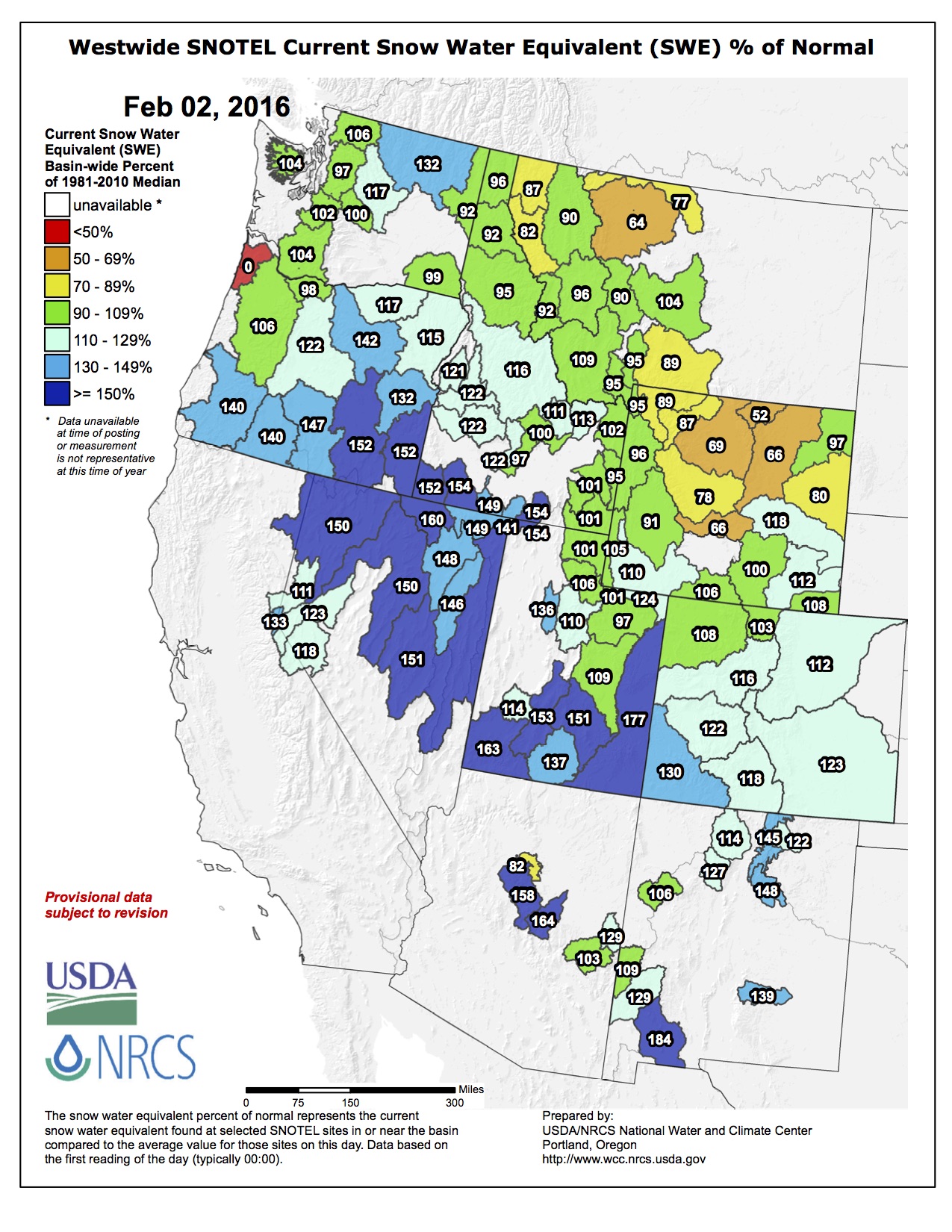
#Snowpack news: SW basins tops in state = 130%

Statewide snowpack February 2, 2016 via the NRCS.

Arkansas River Basin High/Low graph February 2, 2016 via the NRCS.

Upper Colorado River Basin High/Low graph February 2, 2016 via the NRCS.

Gunnison River Basin High/Low graph February 2, 2016 via the NRCS.

Laramie and North Platte Basin High/Low graph February 2, 2016 via the NRCS.

Upper Rio Grande River Basin High/Low graph February 2, 2016 via the NRCS.

San Miguel, Dolores, Animas, and San Juan Basin High/Low graph February 2, 2016 via the NRCS.

South Platte River Basin High/Low graph February 2, 2016 via the NRCS.

Yampa and White Basin High/Low graph February 2, 2016 via the NRCS.
Fort Collins plans an 800 foot bore to bypass Michigan Ditch pipeline section

From the Fort Collins Coloradan (Kevin Duggan):
The city of Fort Collins is preparing to pay $6.3 million to repair a water pipeline more than 60 miles from city limits.
This would be on top of about $2 million already directed toward dealing with a section of Michigan Ditch that was taken out by a slow-moving landslide south of Cameron Pass.
That’s a lot of money. But given the value and importance of the city’s water supply system, the expenditure is necessary and well-spent, city officials say.
Michigan Ditch moves water from the upper Michigan River basin high in the mountains to the Poudre River basin and city-owned Joe Wright Reservoir.
Portions of the 6-mile-long ditch are open, but a stretch of the ditch carries water through a 54-inch iron pipeline. A 2015 landslide separated the pipeline at its joints, filling it with mud and taking the ditch out of commission.
The city plans to bore an 800-foot tunnel through bedrock behind the slide to protect the pipeline from further disruption. Construction is expected to begin in spring with the goal of having the pipeline ready to carry water in time for the 2017 spring runoff…
the city needs to get the pipeline fixed in order to meet long-term obligations under the terms of a water-use agreement involving Fort Collins, Platte River Power Authority and the Water Supply and Storage Co.
Water from Joe Wright Reservoir and nearby Chambers Lake also must be released to meet terms of an agreement between Fort Collins and Greeley to support aquatic life in the Poudre River, according to city documents.
The rise of humankind, in one mesmerizing map
From to go to The Washington Post website:
One of the first things that jumps out at you from this video is that China and India have always been kind of a big deal. The huge populations of South and East Asia, especially around the Yellow and Ganges rivers, stretches back to ancient times. You can also see early civilizations along the Mediterranean Sea and the Nile River, and in Japan, Indonesia, the Middle East and Sub-Saharan Africa.
By contrast, the Americas are much more sparsely populated. You can see the Aztec and the Inca populations flourish around 1400, as well as some other ancient populations, like the Mayans and the Moche. But the population of the Americas doesn’t really start to boom until after the Industrial Revolution.
If you watch the video closely, you can see some populations wane as well — including Europe’s loss of millions of people from the Black Death, and the fall of the Incan Empire with European colonization.
The http://WorldPopulationHistory.org site includes an interactive version of this map that tells you what civilizations all these dots represent. It also includes a cool site where you can enter your birthday to see how many people were alive on Earth when you were born. For example, if your birth is Jan. 1, 1980, the site shows you that there were 4,449,226,229 other people alive when you were born.
Erie seeks bids for water plant project — The Denver Post

From The Denver Post:
The Town of Erie is accepting bids for the design and construction of the Water Plant Solids Handling Equipment Project at the town’s water treatment facility.
The project includes moving the plant’s powdered-activated carbon system and providing carbon storage. The town also plans to explore options for pretreating water to reduce unwanted tastes and odors.
Bids are being accepted through 3 p.m. Feb. 19.
For more information, visit http://erieco.gov.
The Pueblo County Commissioners approve reveg. along SDS
From The Pueblo Chieftain (Anthony A. Mestas):
The Pueblo County commissioners adopted a resolution Monday to approve findings on revegetation and land restoration efforts by Colorado Springs Utilities under its 1041 permit for the Southern Delivery System.
The findings would allow the release of about $674,000 in bonds held for the 17-mile route of buried SDS pipeline through Pueblo County.
The resolution paves the way for other issues in the permit, the largest concerning stormwater issues dealing with SDS.
The findings for the revegetation items were heard in a public hearing Jan. 25.
“We attempted to be as thorough as we possibly could with this discussion and as fair as we could, not only with the applicant, but also critically important to us, fair to our own citizens,” said Commissioner Terry Hart.
“We want to establish a precedent that any of the conditions that are associated with this project are perpetual and continue as long as the SDS pipeline is in place and functioning.”
As part of the agreement, Colorado Springs Utilities must establish about 90 percent of the vegetation that was there before the project and was disturbed by construction.
“Our experts have gone through and analyzed the area and they say that it has substantially been met,” Hart said.
“There are some areas that still need some work and so that’s what our findings show.”
Hart said the resolution also is in place to make it clear that over time Pueblo County and Colorado Springs will be watching the revegetation to make sure that it maintains itself as well as the restoration.
Hart said the next big obstacle is stormwater issues related to the pipeline.
“That is the biggest of the issues. We are working on that right now,” Hart said.
“Pueblo County is suffering terribly from the conditions that are going on in Colorado Springs. So we are looking for good action to begin to control that problem.”

The latest “The Current” newsletter is hot off the presses from the Eagle River Watershed Council
Click here to read the newsletter.
#Snowpack news: Yampa headwaters doing just fine so far
From Steamboat Today (Tom Ross):
Steamboat skiers and snowboarders prefer their champagne dry, but the relatively wet snow that buried the slopes over the weekend put a big boost into the snowpack on nearby Rabbit Ears Pass, where the amount of water stored in the standing snow jumped from a healthy 126 percent of median Jan. 30 to 135 percent Monday morning with the snow continuing to fall.
The snowpack on Rabbit Ears now contains 18.9 inches inches of water — and counting — compared to the median 14 inches for the first day of February. After measuring 69 inches Sunday, the snow depth at 9,400 feet on the pass had settled to 67 inches Monday morning.
But it’s a different story north of Steamboat Springs beginning at Buffalo Pass and continuing north to snow pack measuring sites maintained by the Natural Resources Conservation Service (NRCS) on the edges of the Mount Zirkel Wilderness Area.
The Tower site on Buff Pass has significantly more snow than Rabbit Ears, as it always does. However, on a percentage basis, the snowpack measurement of 23 inches is just 84 percent of median at 27.5 inches, according to the NRCS.
The pattern repeats further north at the Lost Dog and Mount Zirkel sites at roughly the same latitude on opposite sides of the Continental Divide. Lost Dog is on the western flanks of the Park Range in Routt County where the snow that melts into the streams ultimately finds its way into the Colorado River.
At the Zirkel site on the eastern, or North Park side of the Divide, the water is bound for the North Platte River and finally the Mississippi River.
The snowpack at Lost Dog is 90 percent of median, and at Zirkel, it is 87 percent of median. The combined Yampa/White river drainages stand at 106 percent median snowpack based on 20 measuring sites. That ranks the basin last among the eight major basins in the state with the San Miguel/Dolores/Animas/San Juan Basin leading the way at 123 percent of median. Lizard Head Pass south of Telluride stands at 162 percent of median snowpack.
On the east side of Rabbit Ears in Buffalo Park at an elevation of 9,240 feet, the snowpack contains 10.5 inches of water — 144 percent of median. But the nearby Columbine measuring site at 9,160 feet is at just 101 percent of median with 14.9 inches of water.
Turning to South Routt, the Crosho measuring site at 9,100 feet at the foot of the Flat Tops southeast of Phippsburg has 9.9 inches of water — 146 percent of median.
Southwest Colorado Springs homeowners struggle against the abyss — The Colorado Springs Gazette
From The Colorado Springs Gazette (Ryan Maye Handy):
Rick Sisco’s home in the Skyway neighborhood has been riding a landslide for months. It started as a crack, became a chasm, then a 13-foot cliff.
But because Sisco’s circa-1964 home was built long before Colorado Springs passed its geological hazards ordinance, city officials know very little about the landslide that has ruined Sisco’s property.
It’s part of an estimated $14 million problem now facing the city, involving several older homes in southwest Colorado Springs that have been destroyed or buckled by landslides in the wake of record-setting rains in May. A lack of information is yet another obstacle facing city officials, who are dealing with damaged homes, unstoppable landslides and development concerns.
The city hopes federal aid will cover 75 percent of the $14 million price tag to buy at least 20 homes, but the city and homeowners will pay the remainder.
In the meantime, city officials will also consider updating the geological hazards ordinance, which requires assessments of landslide risk on properties.
While Colorado Springs’ geology is infamous for its landslide potential, the city has not faced a problem of this scale since April 1999, when heavy rains triggered slides and prompted the buyout of 27 homes on the southwest side of town.
Modern landslides in the Pikes Peak region are a consequence of ancient geology. The land that formed Colorado Springs sits on steep and weak shale eroded over millions of years. Because of this, landslides have plagued Colorado Springs since 1959, city records show.
A 1996 landslide prompted the city to pass the first version of the geological hazards ordinance, which required geological assessments for homes in danger zones, such as the Broadmoor Bluffs areas. The ordinance was updated in 1999 and 2011, but older homes like Sisco’s have escaped the city’s scrutiny. Now, nearly two decades after the last rash of landslides, these homes built without geological study are at risk.
“What we know now is that these are very expansive soils,” said Tim Mitros, a city engineer who is helping oversee the landslides for the Office of Emergency Management. “If we would have known that back in the day, we would have required overdigs and underdrains. . But because (these homes) were built back in the ’50s, when we didn’t have a geological hazards ordinance, they are being impacted.”
City officials have informally asked the Housing and Building Association to help them evaluate existing codes, HBA President Tim Seibert said. Re-evaluating codes is an natural part of disaster response and one the city and the HBA have worked on before, most recently after the 2012 Waldo Canyon fire, which prompted drastic changes to fire and building codes for homes in wildfire-prone neighborhoods.
But it’s too early to say if the city’s geological hazards ordinance will change, said Bret Waters, director of the Office of Emergency Management.
“I think after every disaster we want to evaluate not just ordinances, but the entire event,” Waters said. “Could that end up with a change in code? We don’t know at this point. We’ve really got to continue to study this – if there needs to be some solution to prevent it in the future.”
The city plans to look at ordinances adopted by other municipalities affected by landslides, Mitros said. A potential ordinance change in Colorado Springs might target empty land platted before the hazards ordinance was passed, Mitros said.
“We do have a lot of building lots on the west side that were platted before 1996,” he said. “Should we look at those differently? I don’t know.”
#ColoradoRiver: Obama administration aims to reduce US water footprint — The Desert Sun

From The Palm Springs Desert Sun (Ian James):
Deputy Interior Secretary Mike Connor said some of the White House’s objectives include encouraging more recycling of wastewater and promoting investment in water treatment and desalination technologies.
“From a technology standpoint, the administration views this as similar to the great strides that it’s made in the renewable energy area, where we set goals of reducing the costs of solar energy,” Connor told The Desert Sun in an interview by phone last week.
“I think in the area of water, given the impacts of climate change, the issues associated with long-term droughts, questions about sustainability, we’re striving to make and promote those types of investments to help us build resiliency in the long term,” Connor said during a visit to Las Vegas, where he attended a conference on water law.
The White House announced its new “water innovation strategy” last month and plans a summit on March 22, which is World Water Day, focusing on potential solutions to the country’s water challenges. The White House said in a fact sheet about the initiative that with improvements in efficiency, better management practices and more widespread adoption of water reuse technology, “we have potential to considerably reduce water usage by 33 percent.”
Federal officials said that would bring the U.S. more in line with other industrialized nations and could also reduce the country’s carbon emissions by decreasing the amounts of electricity needed to treat and pump water.
Another of the administration’s aims is to encourage research and development to bring down the costs of recycling wastewater and desalinating seawater.
“The overall goal is to achieve ‘pipe parity,’ where you could take these technologies, make available good quality water supplies that can compete with other water supplies,” Connor said, “so that we’re expanding the available resources for water consumption while also promoting efficiency wherever we can.”
During a Dec. 15 meeting at the White House, Interior Secretary Sally Jewell announced the creation of new Natural Resources Investment Center, which will be responsible for encouraging private investment in infrastructure projects and facilitating local water-exchange deals in the West.
“We recognize there are limits to the resources that the federal government can apply towards these water resource challenges,” Connor said, “so we’re trying to promote more public-private partnerships.”
One big reason federal officials are confident it’s possible to reduce the nation’s water footprint is that it’s been done before. Due to improvements in efficiency and conservation, total water use in the United States has decreased in recent years even as the population has grown. Researchers with the U.S. Geological Survey have estimated that the country’s water use in 2010 was about 13 percent less than 2005 – the lowest level since before 1970.
#ClimateChange: Arctic’s oldest ice each week since 1990
#ColoradoRiver: The Nature Conservancy’s Carpenter Ranch is participating in a pilot project aimed at finding better ways to share water resources in the thirsty West
From The Nature Conservancy:
RANCHING AND CONSERVATION GO HAND IN HAND
The Carpenter Ranch, located near Steamboat Springs, is a great site for a pilot project. The ranch is owned by the Conservancy but leased to a rancher who grows hay and raises cattle. The four fields participating in the pilot, totaling 197 acres, were irrigated for only the first half of the irrigation season last summer.Geoff Blakeslee, the Yampa River project director, says that the Conservancy has a long history of combining ranching and conservation and finding creative solutions. “This pilot is an exploratory project to understand the impacts of temporary fallowing on the ranch, the Yampa River and the overall Colorado River system,” he says. “There’s a lot of common interest to find solutions that work for our communities, farms and rivers.”
“Colorado’s Front Range receives about 50% of its water from the Colorado River,” adds Taylor Hawes, the Conservancy’s Colorado River program director. “If a crisis does hit—an even more severe or prolonged drought—the information from projects like this one can be used to design a fair way of sharing the water. It benefits all of us to figure out an equitable path forward.”
Although the short-term consequence of reducing irrigation may be a smaller hay yield and fewer cattle on the Carpenter Ranch this fall, finding ways to share water will ultimately help all who depend on the Colorado River for survival.
#coleg: SB16-044, Sonneburg’s conservation easement bill hearing, February 9

From the Sterling Journal-Advocate (Jeff Rice):
Senate Bill 16-044 is scheduled for a hearing before the Colorado Senate Finance Committee on Feb. 9, according to the bill’s sponsor, Sen. Jerry Sonnenberg, R-Sterling.
The bill would require the state to stop trying to collect back tax credits, penalties, and interest from landholders whose conservation easement appraisals have been summarily labeled “fraudulent” by the Department of Revenue. In an interview over the weekend, Sonnenberg said the largest obstacle the bill faces is the fiscal impact.
“The DOR has to compile those numbers and come up with a fiscal note, that is, what is the cost to the state of enacting that bill,” Sonnenberg said. “What that fiscal note will tell us is just how much we’ve screwed the people by breaking our contract with them.”
Across Colorado more than 700 conservation easements, most of them donated between 2003 and 2007, were created under a state law that for years had no oversight. Thousands of landowners set aside millions of acres of land in return for state tax credits they could use against their own income taxes or could sell for cash to others to help pay their income taxes. At last report, the state had lost as much as $220 million to those tax credits.
Subsequently, state officials summarily deemed hundreds of the land appraisals those credits are based on as fraudulent and the donated land as worthless. No one has ever been charged with fraud, let along convicted of it, in relation to any of those land appraisals.
Sonnenberg’s bill would forbid the DOR from “contesting certain claims for conservation easement claims unless the valuation of the easement is supported by an appraisal from an appraiser convicted of fraud or misrepresentation in connection with preparing the appraisal.”
The bill also calls for a refund of “tax, interest, or penalty paid by a taxpayer” in connection with a contested appraisal that otherwise would meet the bill’s requirements.
Sonnenberg acknowledged that the impact on the state’s coffers could be in the millions of dollars beyond what the DOR is already trying to collect…
The bill is scheduled for a Finance Committee hearing at 7 a.m. Feb. 9 in Room LSB B in the Capitol. Sonnenberg said anyone who wants to attend the hearing or even testify on its behalf can contact his office for assistance.
White River Conservation District’s annual meeting recap

From the White River Conservation District via the Rio Blanco Herald Times:
More than 100 people enjoyed the White River Conservation District’s annual meeting Friday at the Meeker Fairfield Center.
The District was recognized by Colorado State Conservation Board in 2015 as “District of the Year,” and Executive Director Callie Hendrickson received the Conservation Excellence Award by Colorado Agriculture Commissioner Don Brown, “for giving a strong voice to locally led conservation at home, in Colorado and nationally.”
Hendrickson highlighted the district’s’ natural resource priorities including rangeland health, wildlife, water and natural resource information and education…
Attendees were updated on the progress of the Land and Natural Resource Use Plan. Hendrickson asked all Rio Blanco County citizens to be prepared to review and comment on the plan in March. The district will publicize the exact dates of public comment meetings. The plan will then be applied to influence federal regulatory frameworks that govern the management of public lands.
The district recognized Rocky and Sparky Pappas and Travis Flaharty as Conservationists of the Year. President Neil Brennan highlighted the Pappas’ conservation accomplishments, including water development, grazing practices, weed control and community involvement. The Pappases and Flaherty manage first for wildlife and second for livestock.
The property they manage is leased to several local producers to graze sheep and cattle during the summer. The livestock are removed before fall to allow for rejuvenation for wildlife habitat. With the ongoing partnership with Colorado Parks and Wildlife, the Pappas’ and Flaherty reclaimed some farm ground in the Josephine Basin to provide critical winter range for mule deer and to improve the migration corridor for deer and elk.
They battle weeds through aerial applications and are experimenting with biological control such as beetles and pathogens for leafy spurge and thistles. They have improved water quality and quantity by converting manual pumps to solar, adding water tanks and installing pipelines to spread the water across the properties. In addition to their conservation efforts, the three volunteer on local boards such as the Historical Society, and the Flat Tops chapter of the Rocky Mountain Elk Foundation. They also sponsor youth hunts and help approximately 200 Colorado hunters with the Ranching for Wildlife program…
Keynote speaker David Ludlum, West Slope Colorado Oil and Gas Association’s executive director, addressed the audience regarding the various ways industries convey their purpose and message to the public. While industries think they are doing a good job by providing great detail about “how they do their work,” they miss the important message about “why they do their work.”
Ludlum showcased how individuals that “bash” industry and the general public need to hear “industry develops these resources simply to provide the tires for your bicycles, the concrete you walk on, the fiberglass on your surfboards, the polyester and nylon in your clothes, the polycarbonate in your sunglasses, the ethane used to make your artificial hips, the heat you enjoy on a cold night, the gas in your car, the fertilizer used to grow your food, etc.”
Ludlum expressed how important it is that our industries help people understand what they provide for your standard of living. Most people, he said, don’t care “how” you do it until they understand “why” you do it.
#Snowpack news (part 2), statewide snowpack map and basin high/low graphs

Statewide snowpack map February 1, 2016 via the NRCS

Arkansas River Basin High/Low graph January 31, 2016 via the NRCS.

Upper Colorado River Basin High/Low graph January 31, 2016 via the NRCS.

Gunnison River Basin High/Low graph January 31, 2016 via the NRCS.

Laramie and North Platte Basin High/Low graph January 31, 2016 via the NRCS.

Upper Rio Grande River Basin High/Low graph January 31, 2016 via the NRCS.

San Miguel, Dolores, Animas, and San Juan Basin High/Low graph January 31, 2016 via the NRCS.

South Platte River Basin High/Low graph January 31, 2016 via the NRCS.

Yampa and White Basin High/Low graph January 31, 2016 via the NRCS.
Snowpack news: Big snow for #Colorado
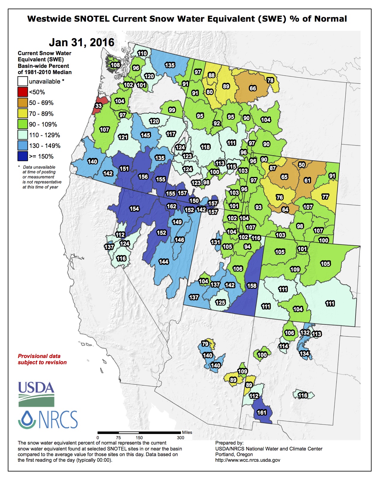
Water park for Eagle?
From the Vail Daily (Pam Boyd):
As Eagle contemplates a plan to develop a water park — complete with in-stream features, beaches, trails and green space at what is currently the truck parking area west of Chambers Park and east of the Eagle County Fairgrounds — the town organized a panel discussion featuring representatives from Colorado towns that have completed their own park projects. This week, a large crowd of Eagle residents gathered to hear about Colorado communities that were transformed by their river park developments. Representatives from Salida, Buena Vista and Golden shared their respective experiences, offered advice as Eagle looks at its own river project and generally shared the notion that great river spaces make great towns even better.
Salida businessman and Arkansas River Trust member Mike Harvey noted that the community is historically a railroad town, and while boat races on the river date back to the 1940s, the waterway was not truly integrated into the community. However, once the trust was formed in the late 1990s, Salida was able to attract grant money for river park projects.
“What has really happened over the past 15 years is the Arkansas River has become a focal point for our community,” said Harvey.
Businesses have sprung up along the river corridor, community events are planned along the riverbanks and the Arkansas has transformed into a community-defining amenity.
“The economic value of the river is significant. It has become the economic attraction for Chafee County,” said Kitson. “It’s not unusual to see 10 tubers, 20 fisherman and 40 rafts on the river on any given day.”
LOOKING FOR BEAUTY
In neighboring Buena Vista, developer Jed Selby saw the Arkansas River as the focus of his South Main development. The multi-use project features housing, retail and restaurant uses and has a strong focus on riverfront space.
“Our town had turned its back on the river,” said Selby.
The first part of his project was a river park, and Selby said he has learned a lot of lessons from his attempts to build perfect in-stream features to attract water sports enthusiasts.
“It’s one thing to have a wave. It’s another thing to have a spectacular wave,” he said. “We have kept at it year after year after year.”
OCCUPY CLEAR CREEK
Rod Tarullo, director of parks and recreation for the city of Golden, noted Clear Creek “has become the heart and soul of Golden.”
Tarullo noted for the past 18 years, the Clear Creek Park has become an integral part of the community, but when 2012 brought an exceptionally hot summer, the park proved almost too popular.
“We called it Occupy Clear Creek,” said Tarullo, while he shared a picture of an average day on the river that year which showed the waterway crowded with inner-tubes and the riverbanks teeming with people.
After that year, Golden undertook a massive master planning process for its popular amenity to make sure is was not loved to death. “We didn’t want to screw it up. We knew that it is something really good,” said Tarullo…
No one argued the potential of the plan, but some residents questioned the cost. The Eagle Town Board is contemplating a sales tax question for the April 5 municipal election that would increase the local tax by 0.5 percent to generate money for the initial phase of development. That tax is estimated to generate around $4 million over a 20-year period and the total park plan is estimated to cost around $10 million. Eagle hopes to attract grants and funding partners to complete the overall vision.
Dara MacDonald, city administrator for Salida, noted that river park development is expensive, but said it can also be the catalyst for broader economic development.
“Private investment follows public dollars,” she said. “There is so much more vitality in our downtown (since the river park development).”
“These river parks are more than water parks. They are magnets for people,” said Harvey.
