Click here to read the current briefing. Here’s an excerpt:
Latest Monthly Briefing – February 12, 2016
Highlights
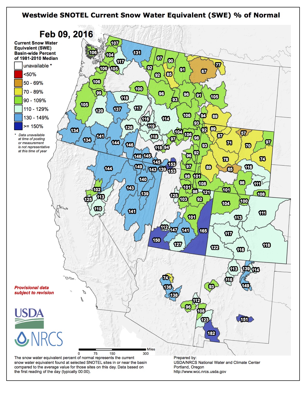
January saw wetter-than-average conditions for most of Utah, with Colorado split between wet and dry, and Wyoming more on the dry side. February had a very wet start for most of the region.
Snowpack conditions have improved in most basins, and are near or above normal in all of Utah and Colorado, and southern and far western Wyoming. Conditions in the rest of Wyoming are lagging well behind normal.
The current El Niño event has peaked but remains very strong. El Niño conditions are nearly certain to continue through the spring, which is reflected in a wet tilt for Colorado and Utah in the seasonal forecasts.
More specifically, the $4.1 trillion budget for 2017 would restore funding to land and water conservation, funnel more money toward water sustainability efforts and impose new fees on hardrock mining.
In a win for conservationists, the budget proposes $900 million toward fully funding the Land and Water Conservation Fund for the 2017 fiscal year, which will start Oct. 1. The LWCF, a 50-year-old program that works to conserve public lands and waters across the U.S. for recreational use and preservation, received a three-year reauthorization in last year’s omnibus spending bill.
In a news release announcing the president’s effort to fully fund the LWCF in the 2017 fiscal year, the U.S. Department of Agriculture said the president would also push toward permanently reauthorizing the fund in 2018. The president sent his proposed budget to Congress on Tuesday…
The Department of Interior’s proposed 2017 budget calls for the implementation of a fee on hardrock mining, with the monetary returns used by various states, tribes and federal agencies toward remediating abandoned mine sites. The budget calls for the royalty fee to be imposed on certain hardrock-mined minerals, such as silver, copper and gold.
Aaron Mintzes, policy advocate with Earthworks, said the process would be similar to the Abandoned Mine Lands fund already in place for coal producers.
“By requiring the hardrock mining industry to pay a royalty for public minerals taken from public lands like the oil and gas industry does, and to pay an abandoned mine reclamation fee like the coal mining industry does, the president’s budget would raise almost $2 billion over the next decade for mine cleanup,” Mintzes said.
According to the Interior Department, the proposed budget also “includes a total of $98.6 million for WaterSMART programs, with $61.5 million for water sustainability efforts through (the Bureau of) Reclamation, an increase of $3.4 million from 2016 enacted.” The program works to improve water conservation and maintain a ready supply of clean and potable water for continued use.
From the La Junta Tribune-Democrat (Bette McFarren):
The abundance of water has caused the Pueblo Reservoir to make plans to start limited spills to control the water level. The top of the active conservation surface elevation is 4,880.38 feet or 245,373 acre-feet. The reservoir is, as of Tuesday, at or above 259,000 a.f. The level must be down to the active conservation number by April 15, so the reservoir will start 2,000 cubic feet per second controlled releases sometime in April, currently projected to be April 12.
The normal end of the winter water season is March 15. Ditches were encouraged to start taking winter water on March 1, if possible, to reduce the total acre-feet in the reservoir. If the farmers are able to take the water early, they will offset the possibility of losing some of their winter water in the required spills. First week of March, most ditch companies will be looking at pre-irrigating so they don’t lose their carry-over winter water from last year, said Jeanette Myers of the Colorado Division of Water Resources.
Just 40 years ago, Pueblo Water would track complaints from customers about “red water” coming out of the faucets.
It stained clothes so badly that cases of heavyduty laundry cleaner were part of the utility’s routine supplies.
“The water wasn’t harmful to customers, but it had an iron taste,” said Terry Book, executive director. “We have very few complaints now.”
“And most of the time, it’s the smell coming from the pea trap (on sinks), that they mistake for coming from the waterlines,” adds Matt Trujillo, director of operations.
Pueblo is not remotely in danger of seeing the same types of problems that Flint, Mich., has experienced recently despite demographic similarities.
Flint experienced increased lead and other contaminants in its water after switching its source of supply from Lake Huron to the Flint River in April 2014 to save money. Within six months, bacteria was found in the water and a boil order was issued. General Motors stopped using municipal water in October 2014 because it corroded car parts.
The Environmental Protection Agency found high levels of lead in the water in February 2015, and elevated levels of lead in blood tests of children in August.
Under state and federal orders, Flint optimized corrosion controls, then switched back to using Detroit’s water supply.
Finally, in December, the city declared a state of emergency, confirmed by President Barack Obama in January.
Like Pueblo, Flint is a relatively poor community of about 100,000 people with aging infrastructure.
Unlike Flint, Pueblo recognized the need to upgrade old waterlines decades ago.
“Since 1978, we’ve concentrated on removing undersized or unlined pipes,” Book said. “Problems like Flint’s have occurred elsewhere. Older communities haven’t had the money to fix problems.”
The Pueblo Board of Water Works anticipated the need back in the 1960s, when it revised its rate structure to include repairs and maintenance.
By the time Book came to work for Pueblo Water in the late 1970s, a waterline replacement program had started. Each year, about $1.5 million is spent on replacing or repairing lines.
At one time most Pueblo waterlines were cast iron, and some dated back to the late 1800s.
There were a few asbestos- cement pipe installations in the mid-1900s.
There were even some wooden waterlines up until a few years ago.
Today, almost all of the delivery lines in Pueblo are PVC or at least ductile iron lined with cement to prevent leaching metals. The exception is an area around North Greenwood Street, with unlined pipes that will be addressed in the near future, Book said.
Pueblo has had relatively little trouble with lead in water because there aren’t many
lead pipes in Pueblo. Only 32 service lines, which connect to individual customers from the mains, are known.
“With the service line repair program (started last year), we’ve replaced one already,” Book said. “They aren’t a big problem because we have hard water, and the calcium coats the inside of the pipes.”
Copper and lead are also monitored each year for the Consumer Confidence Report that is posted on Pueblo Water’s website. The numbers are derived from testing of 50 households — the 32 which have lead pipes leading into the homes and 18 others that have brass fittings that contain lead (no longer allowed under building codes), explained Don Colalancia, water quality manager.
The number reported is the 90th percentile, which is the fifth highest household in the sample. In 2014, 9.3 parts per billion were found, compared with more than 300 parts per billion in Flint.
The report, which is scheduled to be updated next week for 2015 measurements, also provides information about other contaminants, how Pueblo’s water is treated and how facilities such as water tanks are maintained to prevent contamination.
Another factor in water quality safety is the source of supply. Pueblo gets nearly all of its water from Lake Pueblo, completed in 1975 as part of the Fryingpan-Arkansas Project.
“The raw water from a reservoir is generally of better quality and less expensive than taking it from a river,” Colalancia said. “Pueblo Reservoir has high-quality water.”
By using the South Outlet Works at Lake Pueblo, Pueblo Water can take advantage of a manifold that is capable of drawing water from four elevations.
“The reservoir will ‘turn’ at certain times and that affects water quality,” Book explained.
Finally, politics play a minor role when it comes to Pueblo’s water.
In Flint, state and local politics reportedly played a big part in the city’s decision to attempt to save money by switching sources. That led to ineffective efforts to use chemicals to correct the problem, and ultimately more expense to deal with the outcome.
In Pueblo, the Pueblo Board of Water Works consists of five members who are elected for staggered six-year terms. The board makeup has been more consistent than other Pueblo County governments, with most members serving multiple terms. Mike Cafasso, the junior member of the board, has served since 2007. Kevin McCarthy, the senior member, was first elected in 1988.
“It’s a dedicated board,” Book said. “And they’ve always supported the staff.”
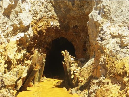
This image was taken during the peak outflow from the Gold King Mine spill at 10:57 a.m. Aug. 5. The waste-rock dump can be seen eroding on the right. Federal investigators placed blame for the blowout squarely on engineering errors made by the Environmental Protection Agency’s-contracted company in a 132-page report released Thursday [October 22, 2015]
Of the 230 inactive mines the state recognized six months ago as causing the worst damage to Colorado waterways, state officials say 148 have not been fully evaluated.
The Colorado Department of Public Health and Environment has cobbled together $300,000 for an “inventory initiative” to round up records and set priorities. The agency is enlisting help from the Colorado Geological Survey at the Colorado School of Mines.
Colorado officials hope attention on the Animas River after the EPA-triggered spill at the Gold King Mine in August will spur action at scores of other inactive mines contaminating waterways. After the disaster, the state identified the worst 230 leaking mines draining into creeks and rivers.
There are an estimated 23,000 inactive mines in Colorado and 500,000 around the West. State officials estimate mining wastewater causes 89 percent of the harm to thousands of miles of waterways statewide.
State records reviewed by The Denver Post reveal numerous examples of day-by-day degradation, but state mining regulators lament they are too poor to launch cleanups and few individual sites qualify for federal Superfund intervention.
“We don’t know what funding is going to be available,” said Bruce Stover, state abandoned mines program director, who has worked on this issue for two decades.
Meanwhile, the EPA is shooting for a lead role on Cement Creek. Here’s a report from Jesse Paul writing for The Denver Post. Here’s an excerpt:
The Environmental Protection Agency has sent a letter to Silverton’s leaders formally proposing a Superfund cleanup of the area’s abandoned mines and full of promises about the controversial remedy.
The memo comes as the town is in the final stages of deciding whether to embrace the Superfund program and seeks assurances about what the federal dollars would mean.
The letter, from the top EPA official overseeing Superfund in Colorado, quells fears about the name of a national priority site and says the remediation would include the development or study of new mine cleanup technologies.
“The EPA is committed to early and meaningful community participation during the entire Superfund process,” wrote EPA official Bill Murray.
The letter, made public Friday, says the town and San Juan County have agreed to call the project area the “Bonita Peak Mining District Site.” Silverton’s leaders worried that naming the cleanup after their community would scare away visitors and destroy their tourism-based economy.
“We received the letter shortly before it was made public,” said Mark Eddy, spokesman for Silverton and San Juan County. “We have made good progress in our discussions with the EPA regarding a Superfund listing. We are reviewing the letter to determine the full impact of the commitments the EPA has made.”
The EPA also promises to actively include local input in the remediation and be open to shrinking the site’s boundaries depending on the amount of contaminants found.
Also, the EPA official in charge at the Gold King Mine knew about the blowout risk, according to this report from Jesse Paul writing for The Denver Post: Here’s an excerpt:
The Environmental Protection Agency employee overseeing work at the Gold King Mine was aware of blowout danger at the site before a massive August wastewater spill, according to a report released Thursday.
The revelation, in findings by congressional Republicans, comes in contrast to the EPA’s claims that the risk was underestimated ahead of excavation at the mine’s collapsed opening. That work ultimately led to the disaster.
Hays Griswold, the agency’s on-scene coordinator, wrote in an October e-mail to other EPA officials that he personally knew the blockage “could be holding back a lot of water and I believe the others in the group knew as well.”
“This is why I was approaching (the mine) as if it were full,” he wrote of the day of the Aug. 5 release at the Gold King.
The note provides more indications the EPA probably had knowledge of the potentially looming disaster at the mine long before workers accidentally unleashed 3 million gallons of contaminants. The Oct. 28 e-mail came in response to an independent Bureau of Reclamation report about the spill released six days earlier.
A Master Leasing Plan doesn’t sound provocative, but bitter lines have been drawn as a result of the Bureau of Land Management planning the future use of its federal land in Southwest Colorado, 92 percent of which is open to gas and oil development.
Debate now lingers over whether the BLM should engage in such a plan to further analyze when and where new wells should be drilled.
Conservationists and recreationists in support of a master plan say the study will give natural resources and recreational uses the same level of priority as gas and oil development, which the BLM has historically favored.
Energy companies and those dependent on the industry argue the BLM already has protections in place, and the call for additional review is a cheap attempt by those who wish to see fuels remain in the ground.
The BLM falls somewhere vaguely in between.
Leveling the playing field
Around 2010, the Tres Rios BLM office estimated up to 3,000 new wells would be drilled over the next 20 years for federally controlled minerals in western La Plata County and eastern Montezuma County.
And within the 820,000-acre area of minerals, only 62,000 acres would be closed to drilling.
The plan caught the ire of some community members who felt the boundaries come too close and adversely impact naturally valued lands, including the corridors into Mesa Verde National Park and Canyons of the Ancients National Monument, around the mountain biking destination Phil’s World and on the edge of two wilderness study areas.
In February 2015, the BLM released an updated Resource Management Plan, outlining guidelines for land use, including future exploration and development of new well pads in the region.
But environmentalists say the resource plan fell short of keeping oil and gas in check, leaving too many areas of discretion and loopholes for over-development.
Concerned with effects on wildlife migration, cultural resources, water quality and air quality, the groups pressured the BLM to consider a master plan, which could tighten restrictions in the two-county area.
“We’re not going to make the entire area on the map a park,” said Nada Culver, director and senior counsel for the Wilderness Society. “The idea is to get more balanced with oil and gas. (A master leasing plan) takes resources like wildlife, recreation, agriculture – and evens the playing field.”
Bringing together interests from across the board, the BLM set up and assigned an advisory committee to draft a recommendation on whether a master leasing plan is warranted. A sub-group of that committee is holding public hearings in Durango and Mancos on Thursday.
Delay tactics?
But not all are in favor of a second look at resources and interests on BLM lands.
“This is being done for political reasons,” said Eric Sanford, operations and land manager for SG Interests, which is representing the energy industry on the sub-committee…
BLM has final say
BLM officials pointed to the $247 million the state of Colorado received in 2015 from royalties for all federal minerals, including oil and gas, as well as the more than 22,900 jobs tied to the industry’s operations on public land.
The BLM Tres Rios Field Office will receive the advisory committee’s recommendation in August, but ultimately, the federal agency has the final say whether it will undertake a master leasing plan project.
“We haven’t taken a stance one way or the other,” said Justin Abernathy, assistant field manager for the BLM’s Tres Rios office. “We’re a multiple-use agency, and in my experience with BLM – the people, the employees really try to balance their approach on how we manage public lands we’re responsible for.”
The BLM ceased all gas and oil leasing on the area in question until the matter of a master leasing plan is resolved. Still, the federal agency has 35 previously authorized leases covering about 13,500 acres within the master plan’s boundaries.
Between the 3,740-square-mile area that covers La Plata and Montezuma counties, the most recent data show nearly 6,000 gas wells dot the countryside.
Throughout the mineral-rich San Juan Basin, the total number of drilling operations are hard to pin down, yet some reports reach into the tens of thousands.
And numbers like those make the battle for the landscape of the West worth fighting for, the Wilderness Society’s Nada said.
“This is a new culture,” Nada said. “The BLM has historically left it up to the oil and gas industry to decide when and where they drill.
“We’re in a new territory for everyone where the BLM and public are gong to mix in.”
Colorado abandoned mines FromThe Durango Herald (Peter Marcus and Edward Graham) via the Cortez Journal:
The Gold King Mine blowout six months ago that dumped 3 million gallons of orange sludge into western waterways spurred action that could lead to remedies for the long-standing problem of toxic drainage from thousands of abandoned mines.
A flurry of bills has been introduced in Congress, and Colorado Gov. John Hickenlooper established a task force to identify priorities for restoring inactive mines across the state.
But it’s not a small problem, and there are no quick solutions…
“I think those photographs of the orange Animas River focused people’s attention in a way that wasn’t focused before,” U.S. Sen Michael Bennet said of the renewed efforts in Congress to address the nation’s mining legacy. “I’m not saying at the local level. I think people at the local level understood that this has been an issue for a long time, but I think that this has caught the attention of Congress finally.”
Bennet, a Democrat, and Republicans Sen. Cory Gardner and Rep. Scott Tipton have crafted Good Samaritan legislation that would provide liability protection for third-party groups to pursue mine cleanup efforts. Although their legislative efforts preceded the mine spill, the fallout has renewed attention on the need to remediate abandoned mines.
“This is something that I’ve been supportive of for as long as I’ve been in public office, but this certainly gives it a stronger impetus and perhaps momentum to finally finish the job,” Gardner said.
Last month, Hickenlooper unveiled the Mining Impacted Streams Task Force, which includes state water, mining and salt and hazardous waste officials, as well as federal agencies.
The goal is to identify gaps in data by pooling resources from the Water Quality Control Division, Colorado Division of Reclamation Mining and Safety, U.S. Forest Service, U.S. Bureau of Land Management and tribal entities, among others.
Researchers will look at water-quality data going back 30 years to take a full watershed approach, examining water from the Upper Animas River Basin to Lake Powell.
Hickenlooper wants to turn disaster into action, pointing to the resiliency of the Durango community.
“Do we come out stronger?” Hickenlooper asked. “That’s the hope … Otherwise, you’ve lost so much. If you say you’re going to build back to almost as good as we used to be, that’s like nature’s winning.”
Hickenlooper wants the task force also to identify new technologies that could assist with reclamation efforts.
“We’re looking at what are some out-of-the-box ideas on how you address mines like this, mines that show some great risk,” the governor said.
Having data and identifying priorities to tackle the inactive mines also provide ammunition for getting federal help, including possible Superfund listings for sites across the state and encouraging Congress to pass “Good Samaritan” legislation…
“We believe that with good, appropriate Good Samaritan legislation that we can actually achieve that goal and we hope that we’ll be able to find that good common ground – sensible common ground – to do what we would all like to have done, and that’s to be able to clean up these areas,” [US Rep. Scott Tipton] said.
Patrick Pfaltzgraff, director of the Colorado Water Quality Control Division, said the new state task force and other efforts will allow the long-standing problems to be addressed.
“There’s a bunch of different impacts throughout the state in the mining district that we’re going to have to look at and try and get our arms around,” Pfaltzgraff said.
“I need a site picture as to what the problem is before you can even think about what you’re going to do by way of treating it. Then we can start providing decision-makers with the information that will allow them to make those next-step decisions.”
Hickenlooper added, “With good people, or good communities, many times bad things do create better conditions. I think this might be one of those cases where it is going to be stronger.”
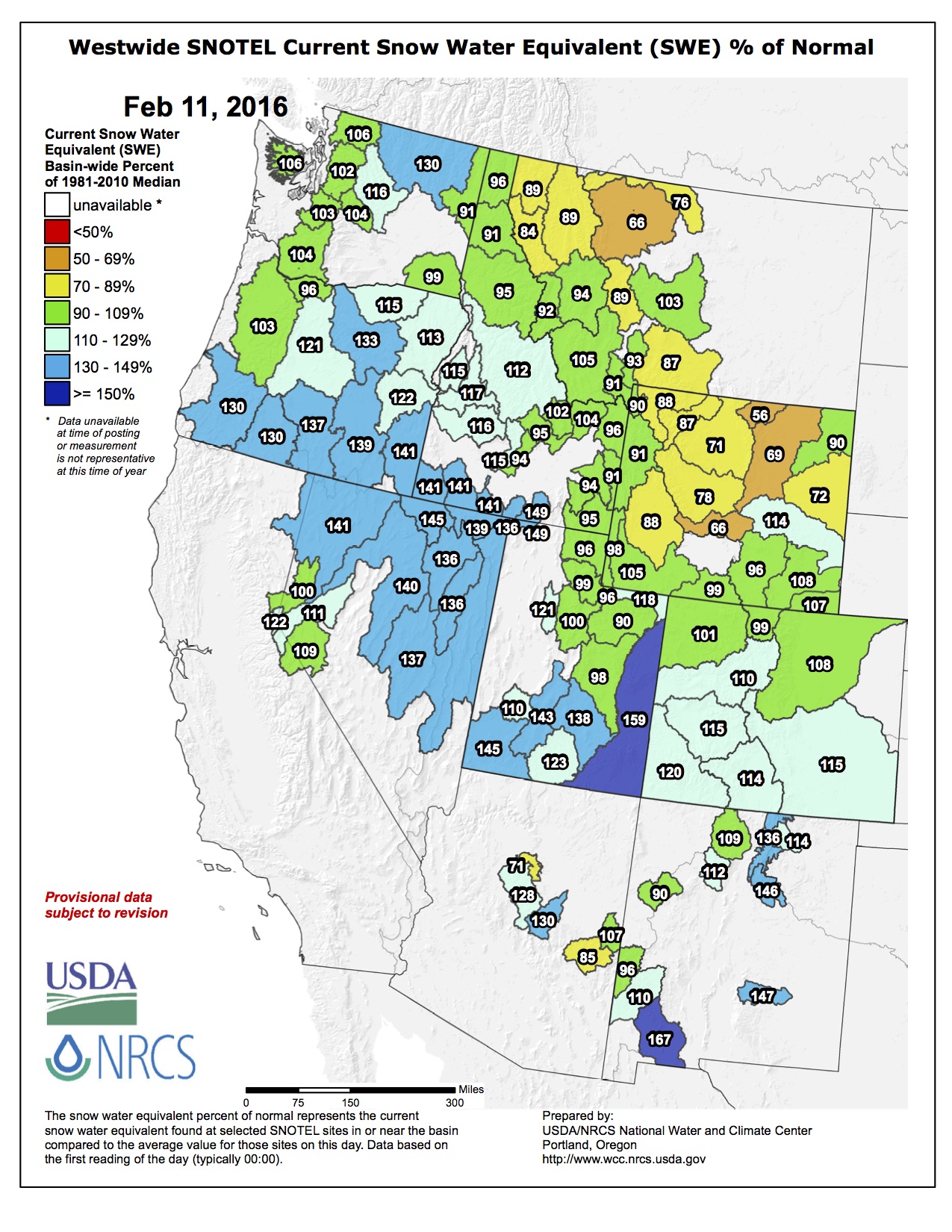
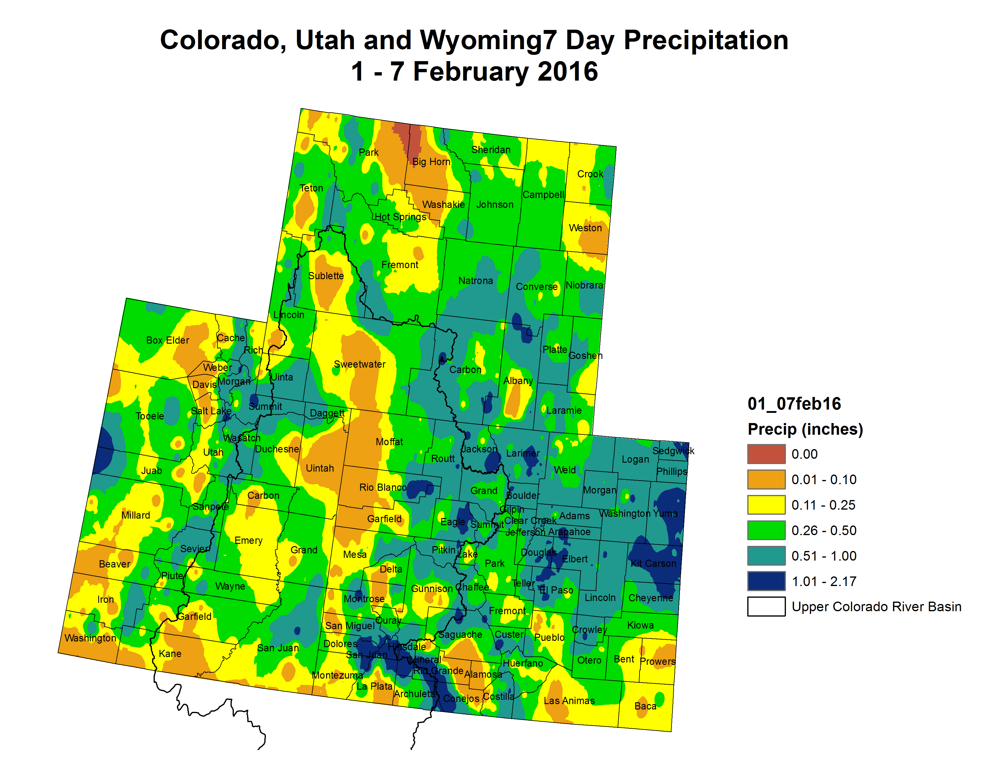
The Feb. 1 snow survey found that snow pack above Middle Park is 112 percent of the 30-year average, according to the USDA Natural Resources Conservation Service Kremmling Field Office.
The average is based on readings taken between 1980 and 2010.
February’s reading shows snowpack is currently sitting above last year’s, which was at 100 percent of the average in February.
“This is the Feb. 1 reading, and we’ve got quite a bit of the winter still left, so stuff can still change,” said Mark Volt with NRCS Kremmling. “Either we can get lot more than normal or a lot less than normal.”
March is typically the snowiest month of the year.
The average snow density is 24 percent, meaning there are 2.9 inches of water per foot of snow, according to NRCS Kremmling…
So far, major river basins across Colorado are also reporting higher than average snowpack.
The upper Colorado River Basin is at 104 percent, the Gunnison River Basin is at 109 percent, the South Platte River Basin is at 101 percent, the Arkansas River Basin is at 109 percent, the Upper Rio Grande Basin is at 102 percent, and the San Miguel, Dolores, Animas and San Juan River Basins are at 110 percent, according to NRCS Kremmling.
Statewide snowpack was at 111 percent of normal on Feb. 1, according to NRCS Denver…
The April 1 snow survey is typically the most important in terms of characterizing the state’s runoff, Volt said.
Rio Grande and Pecos River basins FromThe Pueblo Chieftain (Matt Hildner):
The board of the Rio Grande Water Conservation District found a familiar face to become its general manager.
Cleave Simpson was appointed to the post at the end of last month after working for nearly two years to help the district initiate groundwater management subdistricts across the San Luis Valley.
And while the district could see a host of issues in the coming years, the implementation of the voluntary efforts to mitigate the damage from groundwater pumping and restore the aquifers will remain a priority.
“If we’re smart about it, it’s just a small incremental change,” Simpson said. “If we’re haphazard and not thoughtful about it, it’s a fundamental change and we really need to be cautious about that.”
Subdistrict No. 1 already is in operation but the district hopes to lead the implementation of as many as five others.
The implementation of the subdistricts will proceed alongside the state’s efforts to impose groundwater rules, which are also meant to protect surface water owners and restore the valley’s two major aquifers.
The district takes in all of the valley’s counties with the exception of Costilla County.
Simpson will oversee a host of other issues in his day-to-day work, including a conservation plan to recover the southwestern willow flycatcher and yellow-billed cuckoo, planning for the Rio Grande Natural Area and the district’s move to a new building in mid-March.
Simpson has spent the bulk of his professional career as a coal-mining engineer mainly in Texas but also for two years in Australia.
His other career, one that continues to this day, is farming and ranching.
He grew up on a farm in Alamosa County and now runs his own while also lending a hand to his father’s operation.
“I’m still an irrigator,” he said. “I own surface rights and I own groundwater rights.”
The district has kept former General Manager Steve Vandiver on to assist Simpson in the transition.
Ralph Curtis, who managed the district until 2005, has also stayed in touch with Simpson.
“I’ve never assumed a position where I had the affordability of gentlemen like Steve and Ralph to rely on,” he said. “It feels like this safety net.”
Anticipating a storage crunch later in the spring, Pueblo Water is inviting Arkansas River basin water users to bid on raw water leases.
“A lot of it is about trying to get our upper reservoir water levels down at Clear Creek, Turquoise and Twin Lakes,” said Alan Ward, water resources manager for Pueblo Water. “The leases now are driven by what’s in storage, not any prediction of what we’ll get in 2016.”
Pueblo Water is trying to make space for water it expects to gain this year, so will lease at least 20,000 acrefeet (6.5 billion gallons) of water through the spot market this year. That’s more than typical because 2015 was a wet year, with the trend likely to continue and make storage space tight again.
“If additional water is available, additional proposals may be approved in later months,” Ward said.
Two separate sets of contracts are being offered. One group would provide 15,000 acre-feet of water before May 31, while the other offers 5,000 acre-feet that must be taken by the end of the year.
The water is leased to the highest bidders, and can vary throughout the season. Last year, in February, more than 10,800 acre-feet were leased for prices over $100 per acre-foot. But after heavy rains in May and June, there were few takers for additional water. Pueblo Water was able to lease some to Fowler and the Lower Arkansas Water Management Association for about $50 per acre-foot in early summer and to Colorado Parks and Wildlife for $15 per acrefoot in late summer.
Bids for raw water must total a minimum of $500 and be returned to Pueblo Water by Feb. 11. Water leased through this program cannot be used to grow marijuana.
From the Colorado Springs Business Journal (John Hazlehurst):
Recent studies in Fountain, Security and Widefield show that the water there is contaminated with industrial chemicals that could cause a public health hazard.
Known as perfluoroalkyls, or PFAs, research suggests the chemicals are potent carcinogens and endocrine disrupters at levels far below the Environmental Protection Agency’s provisional exposure limits for drinking water.
And no one seems to know where the contaminants are coming from — or even that they were there in the first place. The city of Fountain’s 2015 Drinking Water Quality Report doesn’t mention PFAs or any other “unregulated reportable contaminant.”
Ron Woolsey, who heads Fountain’s Water Department, was unaware of any PFA contamination of the city’s water supply or of the EPA test results. It’s not clear if the EPA reported these results to the three affected systems.
“We get about 70 percent of our water from the Frying Pan/Arkansas project, via Pueblo Reservoir,” he said. “The remaining 30 percent comes from wells in Fountain and wells on the Venetucci Farm that we share with Security and Widefield. When [CSU’s] SDS [Southern Delivery System] comes on line, we’ll get 100 percent of our water from Pueblo Reservoir.”
[…]
It could be that water from Fountain Valley wells or surface water sources are contaminated by either landfills or residue from industrial processes, but no one is really sure.
WHAT ARE PFAS?
Perfluoroalkyls were first developed by 3M in 1951. DuPont used them for decades to manufacture common commercial products such as Teflon and Scotchgard.
Many are ubiquitous in world ecosystems. Once in a fish, a bird or a human body, they neither decay nor metabolize. The chemicals have been found in people’s bloodstreams, in polar bears in the Arctic and salmon caught in Alaska.
PFAs are highly toxic, but it has long been assumed by public health officials that minute quantities in drinking water pose no risk.
But that might not be the case.
TESTS CONFIRM
Although industrial use of these compounds has been curtailed recently, EPA testing has found that 6.5 million Americans in 27 states are exposed to PFA-tainted drinking water. The chemicals have been detected in 94 public water systems — including the three El Paso County systems.
According to information on the EPA’s website, PFAs are present in drinking water systems that serve 70,000 customers in El Paso County; the agency found more than 200 contaminants in 106 tested samples with a maximum contaminant level of 1.3 parts per billion — among the highest levels of all the water systems that showed evidence of PFA contamination.
“In January 2009,” according to the EPA’s website, “the EPA’s Office of Water established a provisional health advisory of 0.2 micrograms per liter for PFOS and 0.4 µg/L for PFOAs to assess the potential risk from short-term exposure of these chemicals through drinking water. PHAs [advisories] reflect reasonable, health-based hazard concentrations above which action should be taken to reduce exposure to unregulated contaminants in drinking water.”
[…]
CHANGING REGULATIONS
But the EPA might soon deliver new regulations based on recent studies. A paper by Philippe Grandjean of the Harvard School of Public Health and Richard Clapp of the University of Massachusetts-Lowell published in the journal “New Solutions” found that PFAs are hazardous at much lower levels. They can cause cancer, heart disease, birth defects and weaker immune systems.
“Grandjean and Clapp suggested that the EPA’s approach in 2009 led to a presumed safe level ‘at least two orders of magnitude’ higher than the newer studies indicate would protect human health with an adequate margin of safety,” the Environmental Working Group said in an analysis of the study. “… lower than the EPA advisory level by a factor of more than 1,300.”
About 200 prominent scientists worldwide signed the 2015 Madrid Statement, calling on the international community to limit the production and use of PFAs. The statement noted the “growing body of epidemiological evidence” linking PFAs to testicular and liver cancer, liver malfunction, hypothyroidism, high cholesterol, ulcerative colitis, obesity, decreased immune response to vaccines, reduced hormone levels and delayed puberty.
If EWG’s calculations are correct, drinking water in Security, Widefield and Fountain could contain hundreds, even thousands of times the safe level of PFOA and PFOS contaminants. Other PFA contaminants detected in the three systems include perfluoroheptanoic acid, perfluorohexanesulfonic acid and perfluorobutanesulfonic acid.
A REGULATORY TANGLE
Thanks to legal constrictions, the EPA has little power to regulate industrial chemicals such as PFAs.
“Under the 1976 Toxic Substances Control Act,” reporter Nathaniel Rich pointed out in a recent New York Times article, “the EPA can test chemicals only when it has been provided evidence of harm. This arrangement, which largely allows chemical companies to regulate themselves, is the reason that the EPA has restricted only five chemicals, out of tens of thousands on the market, in the last 40 years.”
Lawsuits related to a class action against DuPont for harmful use of PFAs have been making their way slowly through the courts. Filed on behalf of thousands of residents of Ohio and West Virginia, the suits allege that DuPont is responsible for adverse health effects from PFA pollution of multiple drinking water systems.
While there are no certain guidelines that specify PFA drinking water safety levels. The lawsuit against DuPont in West Virginia included anyone whose drinking water had PFOA or PFOS levels above 0.05 parts per billion.
Water provided to residents of Fountain, Security and Widefield showed maximum PFA contaminant level of 1.3 ppb, 26 times greater than the 0.05 cut-off for West Virginia plaintiffs.
NO STATE RECOURSE
Although a handful of states — Minnesota, New Jersey and North Carolina — have established guidelines for PFA contaminants, Colorado is not among them.
CDPHE administers the federal Safe Drinking Water Act, but its regulatory flexibility is limited by state legislative mandate to be neither more nor less restrictive than those set by the EPA. CDPHE is able to give assistance to local water providers.
“We provide assistance to water systems throughout the state,” said Nicole Graziano, CDPHE’s technical and regulatory implementation and coordination unit manager for the safe drinking water program.
“We have a lot of staff who work to assure that drinking water is at the highest level of safety to protect public health.”
Fountain’s Woolsey is determined to find the source of the PFA contaminants and eliminate them. It’s not his first rodeo.
“We went through this sort of thing with Schlage Lock and PCBs (polychlorinated biphenyls) years ago,” he said. “Well pollution has always been a concern. The three systems are all interconnected in lots of ways, so it’s possible that we can identify the source, but it may not be simple.”
The EPA confirmed that the chemicals can be removed from water by implementing treatment at centralized facilities or in homes by installing activated carbon filters.
“The big thing for us, we want the snow to stick around,” said Diane Johnson, public affairs manager with the Eagle River Water & Sanitation District. “The snow is our largest reservoir in the state.”
[…]
As of Wednesday, the SNOTEL site on Vail Mountain (not the Vail Resorts measuring site, but located near Eagle’s Nest) recorded the snow-water equivalent as 104 percent of normal (11.9 inches compared to the 30-year recorded median of 11.4 inches on Feb. 10).
“It means we’re in good standing right now,” said Brian Domonkos, Colorado Snow Survey supervisor for the Natural Resources Conservation Service. “We still have a third of the season to go, and hopefully snowpack will be pretty close to normal.”
Snow-water equivalent at Vail Mountain was at 11.9 inches on Wednesday, and the median peak which comes in late April is 22.6 inches, so it’s about 52.6 percent of the way to normal with a third of the season to go.
DRY SPELL
With the recent high pressure systems in the valley bringing warmer temperatures and no snow, Domonkos said being slightly above normal snowpack acts as a buffer as the season goes along. With temperatures still dropping below freezing overnight, the snowpack is solid enough to stave off a dry spell, he said.
“There’s a bit of a forecast that states we’ll be relatively dry over the next few weeks,” Domonkos said. “And then usually we return to a wetter spell, especially these El Nino years, for the late winter, early spring months — March and April.”
In a small system such as Eagle County, one or two storms can really make a difference, Johnson said. January was at 70 percent of normal snowpack until the big storm that dropped over a foot of a snow at the end of the month and into February, bringing totals to above 100 percent of normal.
In 2013 when Vail Mountain reopened due to late-season snow, local water officials were on edge until the welcome dump of snow, which “totally changed the water picture,” Johnson said.
“One storm can make a difference,” Domonkos said, “but it’s pretty normal to see dry spells, decent storms and dry spells again and kind of get a more stair-step progression.”
RIVER INDICATORS
Regional SNOTEL data from Copper Mountain and Fremont Pass also help local water officials get an indication of what will be melting off the mountains and flowing into local waterways.
As of Wednesday, the SNOTEL site at Copper Mountain read 10.1 inches, 117 percent of the normal, and the data from Fremont Pass measured 10.9 inches, 110 percent of normal.
Copper Mountain stats are indicative of snow-water equivalent in the Vail Pass area, which flows into Black Gore Creek before joining Gore Creek in East Vail. Fremont Pass presents an idea of what will eventually come down to Camp Hale and the Eagle River headwaters, Johnson said.
“We want the snow up high, and we want it to hang around,” Johnson said.
This was the third annual forum, but a first for me. I was asked to participate in the event by its sponsor — the Poudre Runs Through It, a local study/action work group associated with the Colorado Water Institute, which is an affiliate of Colorado State University.
My role was to moderate a panel discussion on how to “get to yes” on major water projects and initiatives. Three of the four panel members participated in long and tough negotiations that eventually hammered out significant operating agreements on projects affecting the Colorado and Platte rivers.
The other panelist was Pete Taylor, a sociology professor from CSU whose research includes studying environmental and agricultural water issues.
I found the discussion interesting, and I hope the roughly 240 people who attended the forum did, too.
I’ve heard mixed reviews: Some folks told me the panel tied in well with past forum discussions.
Others told me they wanted to hear more about the controversial Northern Integrated Supply Project, or NISP, and Glade Reservoir. NISP would draw from the Poudre and store water in Glade, which would be built northwest of Fort Collins.
NISP has been tied up in a federal Environmental Impact Statement process for many years.
Supporters say the project is critical for meeting the needs of growing cities. Some opponents say they will do whatever it takes to kill the project. And so it goes.
Certain words came up frequently during the course of the panel conversation: Collaboration, consensus, commitment, understanding, trust.
The speakers noted that during the course of a negotiation, it is important for participants to understand the perspectives of others at the table.
For example, water supply interests wanting more storage have to understand environmentalists want to keep enough water in rivers to ensure healthy ecosystems.
At the same time, environmentalists have to understand that agricultural interests need to have water flow their way to keep in business. You get the picture.
Achieving understanding between people with deeply different points of view is not easy, the speakers said. Neither is building trust that the entities represented by those people will do what they say they will do as part of an agreement.
But it must be done. And all parties involved have to be committed to reaching some kind of consensus, even if they don’t agree on every element.
Would such an approach work on the Poudre? I don’t know. When it comes to NISP and other projects proposed for the river, the parties seem pretty far apart.
The first step toward finding solutions is talking about them, and that is what the Poudre Runs Through It is trying to do.
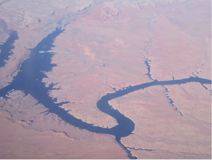
The Colorado River Basin is divided into upper and lower portions. It provides water to the Colorado River, a water source that serves 40 million people over seven states in the southwestern United States. Colorado River Commission of Nevada
Here’s the release from the University of Nevada at Las Vegas:
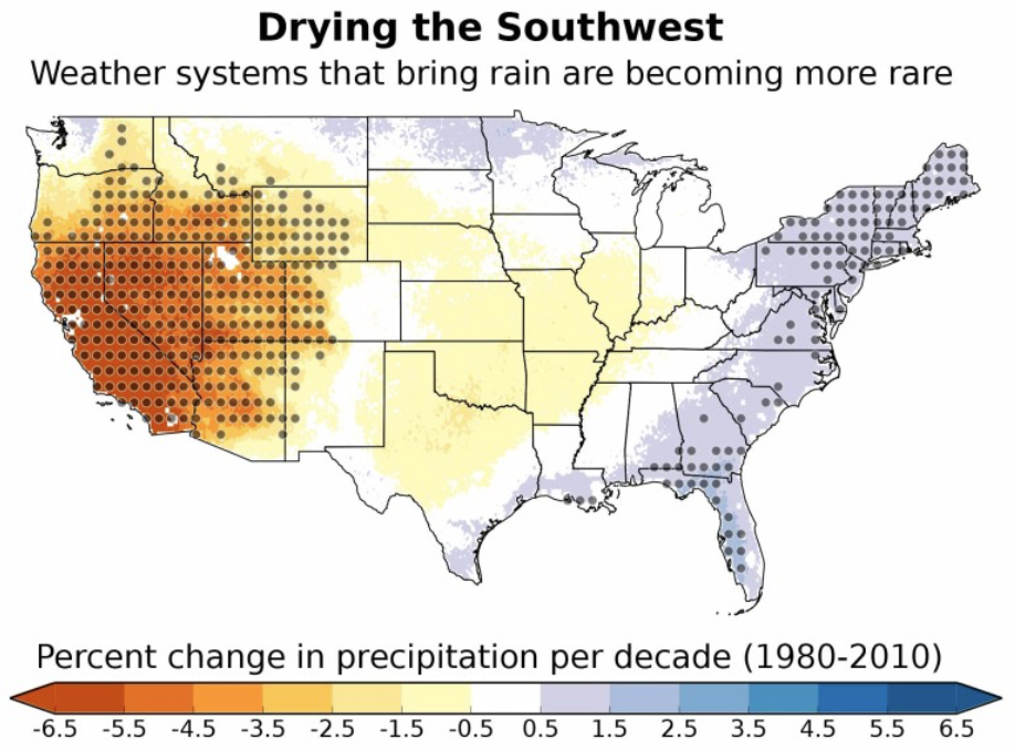
As water leaders contend with unprecedented drought and demand, will the river people of the Colorado band together as regional citizens? Water policy expert Patricia Mulroy weighs in.
It’s 6 am. In Denver, Salt Lake City, Albuquerque, Phoenix, Las Vegas, Los Angeles, San Diego, and Tijuana, someone is stumbling into the kitchen to grab that first cup of coffee. In the wide-open spaces of Wyoming, Colorado, Utah, New Mexico, Arizona, California, Baja, and Sonora, a farmer is opening his head gate to water his field and tend his herd. In the depths of the Grand Canyon, a camper is emerging from his tent to marvel at the sight of an eagle winging across the chasm. Mechanics are adjusting enormous generators sending hydroelectric power to countless communities. And the birds of the Cienga de Santa Clara are heading out to find their morning meal. As distant and different as all this awakening life is, it shares one vital ingredient: water from the Colorado River.
It is a river steeped in legend and lore and often its mere mention induces competition and conflict. For most of the 20th century our competing interests have been in constant collision. Each has jockeyed to advance his needs over those of his neighbors. We quickly forgot the underlying premise of the Colorado River Compact of 1922: that the river was to be developed and managed by seven equal partner states outside the framework of traditional Western water law. Only in the last 25 years have we begun to realize that the framers of this river “constitution” were not as misguided as we thought and that cooperation and joint management of the system would be the only thing that would make a modern 21st century existence on this river possible.
Our supply is dwindling and the demand pressures are not subsiding. As science became more sophisticated and informed, we have come to realize that the amount of available water from this river is not as great as we once imagined it to be. Lawsuits and decrees over the decade further cut into what is reasonably available. And the beginnings of a fundamental shift in the climate conditions affecting the Colorado River Basin are reducing what we do have available even further. We have emerged from one of the wettest centuries in the region to the stark reality of a much drier future. At the same time global food demand is on the rise, urban populations are growing, and an ever-growing environmental ethic is demanding more resources be left in the system to protect the ecosystem.
This interconnected river community has, and continues to be, in an intense period of transformation. The fiercely defended individual water right is beginning to be moved aside by the notion of a shared responsibility and recognized interdependence. Attitudes are slowly changing as water leaders engage their communities in difficult conversations about doing more with less. These changes go right to the heart of how we see ourselves as communities and whether we can envision ourselves as part of a larger region. Yet to be born is the notion of living as the citizen of a river community, enjoying all the rights and responsibilities that accompany that privilege.
Editor’s Note:
Patricia Mulroy, a leader in the international water community, will present the University Forum lecture “Forging a Common Future: Becoming A Citizen of the Colorado River Basin,” at 7:30 p.m., Tuesday, Feb. 16, in the Barrick Museum Auditorium. As the general manager of both the Las Vegas Valley Water District and the Southern Nevada Water Authority, Mulroy helped guide Southern Nevada through an unprecedented period of growth and one of the worst droughts in the history of the Colorado River. She is now the Senior Fellow for Climate Adaptation and Environmental Policy as well as a Practitioner in Residence for the Saltman Center for Conflict Resolution at the UNLV William S. Boyd School of Law.
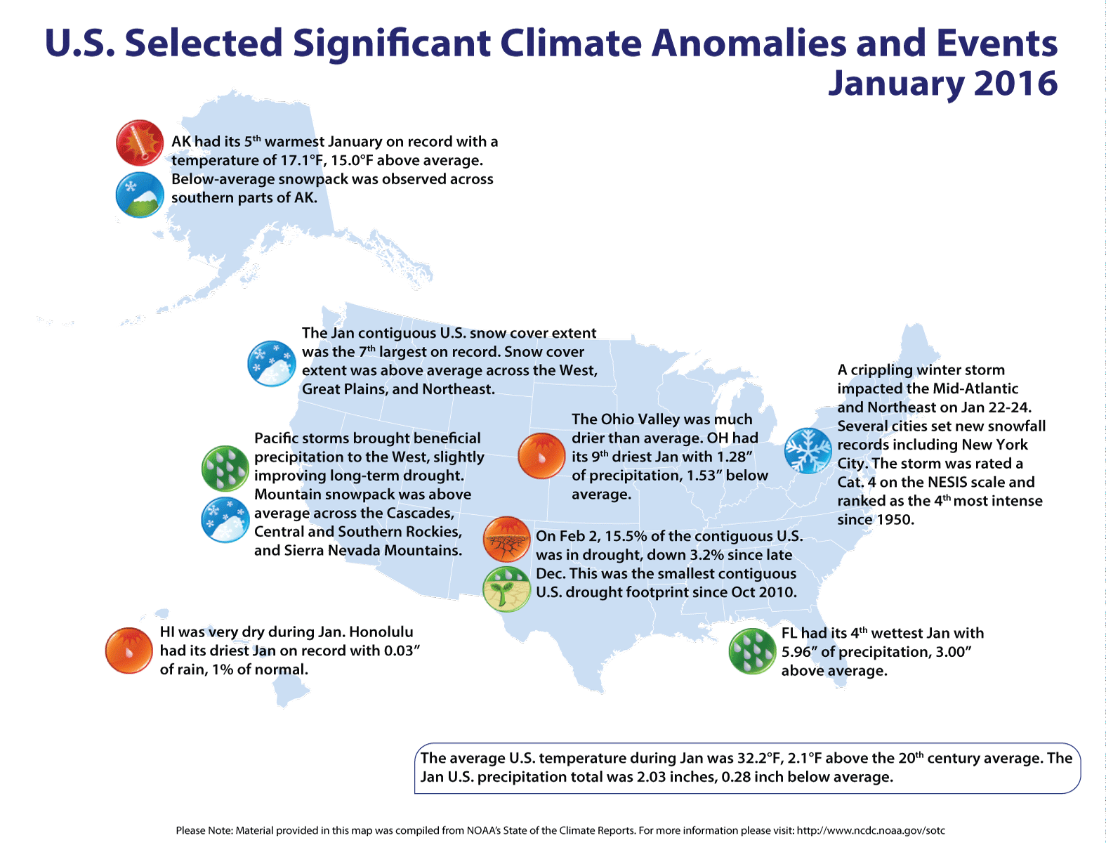
Synopsis: A transition to ENSO-neutral is likely during late Northern Hemisphere spring or earlysummer 2016, with a possible transition to La Niña conditions during the fall.
Indicative of a strong El Niño, sea surface temperature (SSTs) anomalies were in excess of 2°C across the east-central equatorial Pacific Ocean during January. The Niño indices in the eastern Pacific declined, while Niño-3.4 and Niño-4 were nearly unchanged. The subsurface temperatures in the central and eastern Pacific increased due to a downwelling Kelvin wave, but toward the end of the month weakened again in association with the eastward shift of below-average temperatures at depth in the central Pacific. Also, low-level westerly wind anomalies and upper- level easterly wind anomalies continued over much of the tropical Pacific. The traditional and equatorial Southern Oscillation Index (SOI) values remained negative but weakened relative to last month. Convection remained much enhanced over the central and east-central tropical Pacific and suppressed over Indonesia. Collectively, these anomalies reflect the continuation of a strong El Niño.
Most models indicate that El Niño will weaken, with a transition to ENSO-neutral during the late spring or early summer 2016. Thereafter, the chance of La Niña conditions increases into the fall. While there is both model and physical support for La Niña following strong El Niño, considerable uncertainty remains. A transition to ENSO-neutral is likely during late Northern Hemisphere spring or early summer 2016, with a possible transition to La Niña conditions during the fall.
El Niño has already produced significant global impacts and is expected to affect temperature and precipitation patterns across the United States during the upcoming months (the 3-month seasonal outlook will be updated on Thursday February 18th). The seasonal outlooks for February – April indicate an increased likelihood of above-median precipitation across the southern tier of the United States, and below-median precipitation over the northern tier. Above-average temperatures are favored in the North and West, and below-average temperatures are favored in the southern Plains and along the Gulf Coast.
Click here to go to the US Drought Monitor website. Here’s an excerpt:
Summary
From February 2-3, a major low pressure system moved from the central Great Plains northeastward across the Great Lakes region and southern Ontario, accompanied by a variety of hazardous weather conditions to the central and eastern contiguous U.S. These hazards included heavy snowfall and blizzard conditions generally to areas north and west of the storm track, and severe weather to the Southeast. Straight-line and tornadic winds were responsible for most of the severe weather damage. Over the weekend, an area of low pressure developed off the Southeast Coast, accompanied by heavy rain over coastal areas, including most of Florida. This ocean storm tracked to the northeast, well off the Atlantic Coast, bringing heavy snow (generally 6-12 inches) to New England and eastern Long Island, NY. Some locations on Cape Cod also experienced high winds and blizzard conditions, with preliminary reports indicating peak wind gusts near 65 mph in Nantucket…
The Far West
Reservoir storage and Snow Water Content (SWC) data played a large role in the revisions made this week to the USDM map in northern California and southern Oregon. Following is a brief tally of the Percent of Capacity (PoC), and the Percent of Historical Average (PoHA) values for four key reservoir sites in northern California, as given by the State of California’s Department of Water Resources (February 9th): Trinity Lake (PoC 30 percent, PoHA 42 percent), Shasta (55 percent and 79 percent, respectively), Lake Oroville (47 percent and 70 percent, respectively), and Folsom Lake (62 percent and 117 percent, respectively). The Department of Water Resources also provides a Percent of April 1 average Snowpack and the Percent of Normal Snowpack for this date (February 10th), for the Northern Sierra/Trinity region (79 percent and 108 percent, respectively) and for the Central Sierra region (74 percent and 103 percent, respectively). As of February 10th, SNOTEL basin-average SWC values in the California Sierras range from 90-125 percent of average. SWC values in southern Oregon appear to be somewhat greater, ranging from 125-150 percent of average. The Northern Sierra 8-station precipitation index for Water Year 2016 (updated February 5th) shows the average value of this index is 8.4 inches in December, and 9.0 inches in January. For Water Year 2016, however, the December index value is 11.8 inches, and the January index value is 16.1 inches, both significantly above the long-term monthly averages.
Despite heavy rainfall in January, an above-average snowpack and rising reservoirs in many areas, the California State Water Resources Control Board recently approved an 8-month extension of existing drought-related emergency regulations. This is a reminder that although El Nino-related precipitation has been bountiful so far this winter, the drought situation in California remains very serious. Reservoir storage generally remains below-average and very significant groundwater shortages continue. There are also serious problems with tree mortality. The USDA estimates 29 million trees are already dead, and a Stanford group estimates another 29 million trees are showing significant stress. Given these various factors, it will take quite a while for improvements in the short-term to chip away at large, multi-year precipitation deficits.
Adjustments were made to the drought depiction this week in northern California and southern Oregon based on a wide variety of drought indicators and (mainly hydrological) feedback from drought experts across the region. Indicators used from the Western Regional Climate Center’s WestWide Drought Tracker (WWDT) included the Standardized Precipitation Index (SPI) and the Standardized Precipitation Evapo-transpiration Index (SPEI) at various time-scales, and the Palmer Drought Severity Index (PDSI). Current stream flows from the U.S. Geological Survey (USGS), Percent of Normal Precipitation (PNP) values from both ACIS and AHPS, CPC’s drought blends (short-term, long-term, and “worst-case”), and as noted above, SWC and reservoir information. Feedback from drought experts in California and Oregon played a key role in determining the modifications made to this week’s U.S. Drought Monitor.
In northwestern California, the D0, D1, and D2 contours were adjusted slightly eastward. Moderate drought (D1) was extended southward as far as Sonoma and Marin Counties. The D1/D2 boundary (separating moderate from severe drought) was moved slightly to the east, to central Siskiyou County, and eastern Trinity County. Extreme drought (D3) was eliminated from eastern and northwestern Modoc County, and exceptional drought (D4) was trimmed out of Lassen County. In southern Oregon, the D0, D1, and D2 contours were shifted slightly eastward. The D3 in southern Klamath and southern Lake Counties was eliminated. In northeastern Oregon, improved conditions warranted a one-category upgrade for Grant County, from D2 to D1…
The Great Plains and Upper Mississippi Valley
The primary revisions made to the drought depiction this week were in Texas. Most of the state has been drying out the last 30-days, with only two areas receiving more than a half-inch of precipitation. According to the Advanced Hydrologic Prediction Service (AHPS), far eastern Texas received moderate to heavy precipitation (0.5-3.0 inches), and the Trans-Pecos/western Edwards Plateau region generally received between 0.5-1.0 inch. However, many locations around the Abilene/San Angelo area have yet to receive measurable precipitation in 2016. Elsewhere, plant stress and elevated wildfire danger signaled either the expansion of, or introduction of, D0. In particular, deep South Texas has had very low dew points and strong winds. Topsoil moisture is rated by the U.S. Department of Agriculture (USDA) as very short to short. The additions rendered to the USDM map were guided by 1-4 month Standardized Precipitation Index (SPI) blends.
Small changes were also made to the depiction in northwestern Kansas and northeastern Colorado. The eastern portion of the D0 band (straddling the state border) was removed, due to somewhat improved conditions. Abnormal dryness (D0) was retained in Washington and part of Kit Carson Counties in northeastern Colorado, based primarily on SPI and soil moisture considerations.
An area to watch over the next few weeks is northeastern Oklahoma and northwestern Arkansas. This region has been quite dry during the past 30-days, with less than 0.10-inch of precipitation reported. A few counties (such as Franklin and Polk in Arkansas) have issued bans against outdoor burning. Dry spells are not uncommon during the winter, and it is noteworthy that this particular area received 10-14 inches of precipitation in late December…
The Rockies and Intermountain region
In central Nevada, some improvements seemed warranted. Using some of the same tools and indicators noted further down for California and Oregon, a one-category improvement was made to parts of northern Nye, Eureka, Lander, southwestern parts of Elko, and western White Pine Counties. No adjustments were made to the western counties of Nevada, as it takes time for the short-term gains in moisture to have a significant impact on long-term deficits. In southwestern Idaho, snowpack has nearly reached median peak annual values for the period of record. One-category improvements (from D1 to D0) were made in the Weiser, Bruneau, Salmon Falls, Oakley, and Raft basins, yet not to the Owyhee basin. Despite good snowpack, there is a significant lack of reservoir storage. In addition, for a large, low-elevation, high desert basin, a good snowpack doesn’t necessarily translate into adequate runoff…
Looking Ahead
During February 11-15, a half-inch or less of precipitation (liquid equivalent) is forecast for far northwestern California and the western margin of the drought region in Oregon. One to two inches of precipitation is anticipated across northern Idaho and northeastern Oregon. Unfortunately, much heavier amounts of precipitation (3-7 inches) are predicted for parts of the Pacific Northwest which are no longer in drought. Precipitation amounts of a half-inch or less are predicted for the Dakotas and most of the Mississippi Valley, with perhaps an inch for the Ark-La-Tex region, and for downwind areas of the Lower Great Lakes region.
During the ensuing 5 days (February 16-20), the projected precipitation pattern generally favors above-median precipitation from the Pacific Northwest and northern Rockies eastward across North Dakota, and continuing eastward and southeastward across the Great Lakes region, the Ohio and upper Tennessee Valleys, Appalachians, and Atlantic Coast states from Maine to South Carolina. Below-median precipitation is favored from California and the Southwest eastward across central and southern sections of both the Rockies and Great Plains, most of the Middle and Lower Mississippi Valley, and the Gulf Coast states including all of Florida. This pattern is what would be expected of a La Nina winter, not an El Nino winter. At any rate, some drought relief is at least favored across the northern U.S. during this period, but this is not the case for places like (most of) California, the Southwest, and Texas. Dryness is rapidly expanding across Texas, and some degradation in the drought depiction will probably be needed next week.
Take a walk down memory lane with early February US Drought Monitor maps since 2010.
From from the Associated Press (Susan Montoya Bryan) via The Durango Herald:
The head of the New Mexico Environment Department blasted the U.S. Environmental Protection Agency on Wednesday during a legislative committee meeting, saying federal officials are downplaying the long-term effects of the Gold King Mine spill.
Environment Secretary Ryan Flynn told members of the House agriculture committee that the agency has been pressuring communities to get behind a proposal that calls for monitoring water quality for only a year.
Flynn also argued that the proposal would look at whether the water is safe for recreation rather than digging deeper into recurring spikes in the readings of heavy metals that state officials fear could affect crops, livestock and wildlife in the years to come.
The EPA has maintained that water quality returned to normal in the weeks following the Aug. 5 spill. Flynn disputed that, and he pointed to readings taken after a series of storms last fall.
“When storm events occurred, the sediment was remobilized, and we’re seeing the levels of lead and other metals in the river increase well above safe drinking water standards,” Flynn testified. “So the idea that: ‘Hey, everything is back to normal, we’re good,’ is just flat out false and that’s a problem.”
Flynn said the agency needs to treat the incident as a human health issue.
The EPA did not respond directly to Flynn’s criticisms, but noted that it has been working with communities in the region on a draft monitoring plan. Flynn is part of that working group, according to the agency.
“The work group’s goal is to finalize a plan based on broad stakeholder input that has support among the jurisdiction,” EPA spokeswoman Nancy Grantham said in a statement.
State, local government and tribal representatives met last week in Colorado to discuss steps forward, but the timing on a final monitoring plan remains unclear.
A “get well soon” balloon floats in the contaminated waters of the Animas River flowing through Durango on Monday afternoon August 10, 2015 — photo The Durango Herald, Shane Benjamin
The Court for Water Division No. 3 is expected to set a trial date later this month for the proposed state groundwater rules in the San Luis Valley.
That trial date may not come until 2017, according to a draft case management order filed with the court Friday, but a long window before the trial may help State Engineer Dick Wolfe with his goal of coming to an agreement with objectors before trial.
To date, 29 parties have filed comments, although at least three of them did so in support of the rules.
The rules would cover the roughly 4,500 wells that draw off either of the valley’s two major groundwater bodies.
The unconfined aquifer is the shallower of the two and is recharged both by streamflow at the valley’s edge and by return flows from irrigation.
The confined aquifer is recharged mainly by streamflows on the valley rim, sits beneath the unconfined aquifer and holds artesian pressure.
Both are hydraulically connected, in varying degrees, to stream flows in the valley, meaning that groundwater pumping can injure surface water users.
The rules are designed to protect surface water users and restore aquifer levels by requiring groundwater users to either join a groundwater subdistrict, create an augmentation plan, or create a substitute water supply plan.
All three would require the mitigation of pumping impacts as determined by a staterun computer model that simulates the behavior of the valley’s groundwater.
Comments were filed by 21 parties at the end of November, although the court extended the comment period because of problems noticing the rules in the north end of the valley.
Many of those comments focused on whether the state’s groundwater model was sufficient for the rules.
Since then eight others have also weighed in.
As with previous objectors, there were two protestors among the latest group who argue that the rules only be approved to the extent that the groundwater model is accurate. Other objections focus on the proposed process the engineer’s office would use to set an irrigation season. The subdistrict operating under the Trinchera Water Conservancy District has also entered a protest, calling for the rules to allow it to submit a groundwater management plan. While the valley’s existing subdistrict and the four other proposed ones would all operate under a groundwater management plan, Trinchera is unique in that it is the only subdistrict not operating under the umbrella of the Rio Grande Water Conservation District.
Trinchera is in Costilla County, which is not a part of the Rio Grande district.
The state law that allows for the creation of conservancy districts does not make clear whether Trinchera can create a groundwater management plan.
Click here to read the report. Here’s the executive summary:
Experience with recent disaster recovery efforts highlights the need for additional guidance, structure and support to improve how we as a Nation address recovery challenges. This experience prompts us to better understand the obstacles to disaster recovery and the challenges faced by communities that seek disaster assistance. The National Disaster Recovery Framework (NDRF) is a guide to promote effective recovery, particularly for those incidents that are large- scale or catastrophic.
The NDRF provides guidance that enables effective recovery support to disaster-impacted States, Tribes and local jurisdictions. It provides a flexible structure that enables disaster recovery managers to operate in a unified and collaborative manner. It also focuses on how best to restore, redevelop and revitalize the health, social, economic, natural and environmental fabric of the community and build a more resilient Nation.
The NDRF defines:
• Core recovery principles
• Roles and responsibilities of recovery coordinators and other stakeholders
• A coordinating structure that facilitates communication and collaboration among all stakeholders
• Guidance for pre- and post-disaster recovery planning
• The overall process by which communities can capitalize on opportunities to rebuild stronger, smarter and safer
These elements improve recovery support and expedite recovery of disaster-impacted individuals, families, businesses and communities. While the NDRF speaks to all who are impacted or otherwise involved in disaster recovery, it concentrates on support to individuals and communities.
The NDRF introduces four new concepts and terms:
• Federal Disaster Recovery Coordinator (FDRC)
• State or Tribal Disaster Recovery Coordinators (SDRC or TDRC)
• Local Disaster Recovery Managers (LDRM)
• Recovery Support Functions (RSFs)
The FDRC, SDRC, TDRC and LDRM provide focal points for incorporating recovery considerations into the decisionmaking process and monitoring the need for adjustments in assistance where necessary and feasible throughout the recovery process. The RSFs are six groupings of core recovery capabilities that provide a structure to facilitate problem solving, improve access to resources, and foster coordination among State and Federal agencies, nongovernmental partners and stakeholders. Each RSF has coordinating and primary Federal agencies and supporting organizations that operate together with local, State and Tribal government officials, nongovernmental organizations (NGOs) and private sector partners. The concepts of the FDRCs, SDRCs, TDRCs and RSFs are scalable to the nature and size of the disaster.
The NDRF aligns with the National Response Framework (NRF). The NRF primarily addresses actions during disaster response. Like the NRF, the NDRF seeks to establish an operational structure and to develop a common planning framework. The NDRF replaces the NRF Emergency Support Function #14 (ESF #14) – Long-Term Community Recovery. Key ESF #14 concepts are expanded in the NDRF and include recovery-specific leadership, organizational structure, planning guidance and other components needed to coordinate continuing recovery support to individuals, businesses and communities.
Fundamentally, the NDRF is a construct to optimally engage existing Federal resources and authorities, and to incorporate the full capabilities of all sectors in support of community recovery. The effective implementation of the NDRF, whether or not in the context of a Robert T. Stafford Disaster Relief and Emergency Assistance Act (Stafford Act) declaration, requires strong coordination across all levels of government, NGOs
and the private sector. It also requires an effective, accessible public information effort so that all stakeholders understand the scope and the realities of recovery. The NDRF provides guidance to assure that recovery activities respect the civil rights and civil liberties of all populations and do not result in discrimination on account of race, color, national origin (including limited English proficiency), religion, sex, age or disability. Understanding legal obligations and sharing best practices when planning and implementing recovery strategies to avoid excluding groups on these bases is critical.
The NDRF is a guide to promote effective recovery. It is a concept of operations and not intended to impose new, additional or unfunded net resource requirements on Federal agencies. As responsibilities, capabilities, policies and resources expand or change, the NDRF will be revised as needed to ensure that it continues to provide a common and adaptable approach to disaster recovery.
Click here to read the newsletter. Here’s an excerpt:
River District to funnel $8M to irrigation projects
The Colorado River District Board of Directors has agreed to act as a funding conduit for up to $8 million in federal Natural Resourc- es Conservaon Service (NRCS) funding to help fi- nance a series of water use efficiency projects in four federal irrigaon projects in the Lower Gunnison Basin.
Last year, the River District was awarded $8 million of grant funding from the U.S. Department of Agriculture’s 2014 Farm Bill that will leverage up to $50 million worth of work in cooperaon with, and other funding from, the Bureau of Reclamaon and the Colorado River Basin Salinity Program.
The Board approved a new type of financial coop- erave agreement called an “Alternave Funding Arrangement” that enables the River District to act as an agent of the NRCS.
The Board directed staff to manage all of the NRCS funding for the benefit of the irrigaon districts in the four focus areas..
The four beneficiary irrigation project areas include the Uncompahgre Valley, Bostwick Park, the North Fork Valley and the Crawford Country. Deputy Chief Engineer Dave Kanzer and Water Resources Specialist Sonja Chavez have been the quarterbacks in the collaborative effort to perform mod- ernizaon and system opmizaon acvies that will increase agricultural water use efficiency within the Lower Gunnison Basin.
Kanzer noted that the irrigaon districts can lose more than 30 percent of their water to seepage and deep percolation.
The Regional Conservaon Partnership Program (RCPP) funding from the NRCS will help minimize those losses by modernizing river diversions and water conveyance and deliveries for farm use. This work, combined with en- hanced management of reservoir releases, is projected to provide beneficial results related to increased agricultural producon, improved stream flows, beer water quality, and improved river habitat that, among other benefits, will help threatened and endangered fish species.
“In my view, this has to be done for the future of our agricultural producers in the basin,” said Eric Kuhn, General Manager of the River District.
Marc Catlin, River District Director from Montrose County, said: “The future is here, and we have got to start doing these things if we are going to maintain agriculture on the Western Slope.”
He called for the program to work with younger producers to help them learn how to farm with new technology.
“This is a big deal,” said Dave Merri, Director from Garfield County. “This is the product of 20 years of work in the Gunnison Basin. It is a great way to go ahead and put good stuff on the ground.”
Gunnison County Director Bill Trampe urged that the program provide an economic analysis of projects to help educate others to the pluses and minuses of the modernisations.
Tom Kay, an organic agricultural producer from Hotch- kiss, who has already implemented irrigation improvements, said his growing season has been lengthened due to beer water management that effecvely has stretched his water supplies. “Without Dave Kanzer and Sonja Chavez, this would be nowhere,” Kay said of the River District staff working on the project.
Gunnison River Basin via the Colorado Geological Survey
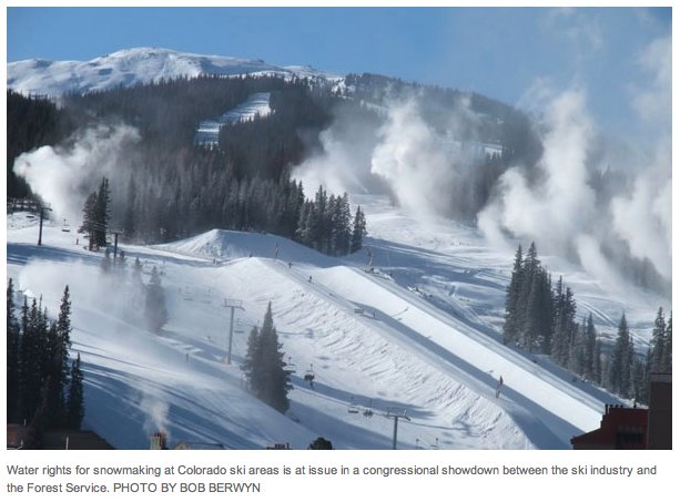
In late December, the U.S. Forest Service announced a compromise with the ski industry in their feud over water rights. Both sides gave ground, but just as interesting was who didn’t get deeply involved.
The environmental community mostly stayed on the sidelines, unwilling to hurl spears on behalf of the Forest Service. U.S. Rep. Scott Tipton, a Republican who represents much of Western Colorado, was triumphant if still warning of federal overreach. He called the Forest Service policy an “onerous attempt to hijack private water rights.”
In this king-sized bed of political alliances, there was some unusual spooning going on. Tipton, elected with Tea Party support and a predictable critic of the Environmental Protection Agency, in this case shared covers with the Aspen Skiing Co., which had even dispatched a top official to testify in Congress against federal involvement in water administration.
This matter of who-is-calling-the-shots on water, states or feds, is also part of the discussion in the Colorado Legislature this winter. Boulder-based water attorney Glenn Porzak, who represents the Eagle River Water Authority and other interests, brokered meetings in recent months around a bill now introduced as HB 16-1109, called the Colorado Water Rights Protection Act.
The bill has sponsors from legislators who rarely agree on anything: from Sen. Jerry Sonnenberg, a Republican from the farm country of Northeastern Colorado, to Rep. KC Becker, a Democrat from reliably liberal Boulder. Other co-sponsors are Rep. Diane Mitsch Busch, a Democrat from Steamboat Springs, and Sen. Kerry Donovan, a Democrat from Edwards.
The bill very fundamentally seeks to discourage federal efforts to claim jurisdiction over water rights on federal lands in some cases. Major environmental groups—including Western Resource Advocates, Conservation Colorado, and Trout Unlimited—have agreed to remain neutral.
Water has always been seen as an essential part of the Forest Service mission. That concern is what drove withdrawal of the forest tracts from the general domain beginning with the White River Reserve of northwest Colorado in 1881. Those withdrawals were driven, in part, because of concerns about water quality from timbering and other land uses. States, just as zealously, have been protective of their authority over water allocation. But water quality and water quantity are inextricably linked, and hence tension.
This tension has played out frequently over the decades on a variety of fronts. In the case of ski areas, the Forest Service in the 1980s developed a policy that said any water developed and used on the national forest in an area permitted for a ski area should be in the name of the United States. The federal agency, however, applied this policy inconsistently to ski areas. There are 122 ski areas on Forest Service land across the nation, mostly in the West.
Ski areas never liked this requirement and questioned the validity. Still, 65 water rights were given to the U.S. government, and they remain in the name of the U.S. government.
In 2004, the Forest Service created something called joint tenancy, whereby the ski areas and the U.S. government would together hold water rights. The Forest Service saw itself as being the landlord and the ski area being a tenant and the plumbing (and tap fee) for the house belonging to the landlord. This was applied to a handful of adjudications of water originating on ski areas. Many states, however, do not recognize this concept.
In 2011, the Forest Service issued a new policy. The ski industry objected to the new clause, which required that ski area operators developing new water sources within their permit areas to give the title to the water to the U.S. government.
This new policy was applied to the Powderhorn Mountain Resort, located on Grand Mesa near Grand Junction, Colo. With partners, long-time ski industry executive Andy Daly had purchased the ski area in 2011. As a condition of transferring the permit for use of Forest Service land, says Daly, he and the other new owners were required to transfer the water rights to the Forest Service.
“They said they would not approve the permanent transfer of the permit (from the former owner) unless we agreed to the language,” he says.
Trail map for Powderhorn Ski Area via liftopia
That water portfolio for Powderhorn is 15 pages long and includes a wide variety of sources, from springs to access to a ditch drawing water from Mesa Creek, many rights filed in the 1980s but some predating the creation of the ski area.
At the time, Daly thought the Forest Service had over-stepped.
“In my mind, it was always considered a taking, from the perspective that the Forest Service was taking the water right of the ski area and not guaranteeing that those water rights could be used in perpetuity for what they were being used at the ski area.”
That same year, the National Ski Areas Association sued. The judge agreed, striking the Forest Service requirement—but on procedural grounds, not substantive grounds.
Adhering to the elaborate set of procedures and requirements yielded a new directive that the Forest Service announced in late December. The Ski Area Water Clause entered in the Federal Register clearly constitutes a compromise, if some dissatisfaction remains.
Giving ground
Ski areas give up their autonomy about water rights. They cannot just sell their water rights on the open market. They agree—even if they don’t necessarily believe—that the Forest Service should have some say-so over how much water is needed to run a ski area.
If an operator sells the ski area, the water rights must be included in the assets. If the buyer declines to buy the water, the Forest Service gets the first right of refusal. The Forest Service could decide the water isn’t needed, in which case the ski area would be allowed to sell the water rights to a buyer of its choosing.
Going forward, ski areas can continue to own all the water rights they develop on the ski areas, whether through wells, dams, or diversions. They do not need to transfer them to the U.S. government. However, the directive leaves intact prior water rights filings, including some that were ceded to the U.S. government.
The Forest Service requires ski areas to document sufficient water to support their operations in snowmaking and other uses for on-mountain operations.
The agency does not claim rights to water that originates off the ski permit area. In the context of Colorado, for example, both Vail and Beaver Creek use from the Eagle River, pumping it onto the ski mountains to make snow. Another example is augmentation water, such as that held in Green Mountain Reservoir and released as needed to meet senior water rights downstream by more senior users downstream on the Colorado River.
Jim Bedwell, the director of recreation in the Rocky Mountain region, calls it a good compromise but maintains that the Forest Service has a legitimate need.
“Ski areas do change hands,” he says, “and there is significant consolidation going on in the industry right now. Our real desire is that the public doesn’t see any difference, regardless of changes, and there will be some of the same opportunities for the public to ski, with the same quality of experience—but the water rights will be tied to the forest. That was our interest all along.”
Geraldine Link, director of public policy for the National Ski Areas Association, sees little reason ski areas would get rid of water rights. “Why would you sell the water rights if it wasn’t absolutely crucial?” she says. “That diminishes the value of your ski area.”
NSAA chose not to battle the Forest Service further for a number of reasons, she said: The restrictions apply to a limited class of water rights; litigation is expensive, and the outcome of a lawsuit uncertain.
But the new language gives ski area operators assurances that the value of their investments will be protected. “That’s a big deal for the ski areas.”
She also struck a diplomatic tone, describing ski areas and the U.S. Forest Service as partners for more than 75 years in providing the public with a concentrated outdoor experience, first in snow and now as four-season resorts.
“We have a lot going on. Our partnership is much greater than just water. That is the context for how we look at this new clause and say, ‘This will work for us.’”
Government overreach?
But Tipton proclaimed it a rebuff of Forest Service overreach. “Western water users are right to be wary of any action on water rights by this Administration, which has been dead set on slowly expanding federal control over water in the Western U.S,” he said in a Dec. 30 statement.
Tipton cited support from a number of familiar allies, but some unusual teammates, too, including the Gunnison County commissioners, which trend toward Democratic policies.
Chris Treese, director of internal affairs for the Colorado River Water Conservation District, also questions Forest Service authority. Water use, he argues, should be strictly within the domain of state water courts. Too, he harbors doubts whether the Forest Service should have any say-so in determining how much water is needed to operate a ski area.
“I appreciate the fact that they are no longer requiring ski areas to assign ownership to deed title over to the federal government. That is significant. But I question whether they have the true expertise to determine sufficiency of quantity for water. Exactly how are they going to measure that?” he asks. “There are implications for the private property nature of Western water rights.”
Treese does commend the Forest Service for recognizing in its final rule the fundamental difference between the prior appropriation laws of Western state and the riparian laws of the East.
Bypass flows different
Bypass flows are a related, but different issue—as environmental groups were careful to point out.
In the case of bypass flows, the Forest Service requires that water from dams and other such uses of the national forests lands let a certain amount of water continue to flow downstream, to achieve biological purposes of streams and rivers. After a 2004 federal decision upheld the Forest Service in a case involving a reservoir on the Arapahoe-Roosevelt National Forest, Colorado Trout Unlimited issued a statement that the ruling should “silence those who have asserted that the Forest Service does not have the authority to protect rivers on National Forest lands.”
But while environmental groups strongly support bypass flow requirements, at least some of them suggested—if they were willing to talk at all—that the Forest Service had sharp elbows in the ski area case.
“The best analogy I can make is that if you are a tenant in a building, your landlord can tell you not to play the radio loud after 10 p.m., that’s essentially what a bypass flow is,” explains Rob Harris of Western Resource Advocates.
“It just puts a limit on the exercise of your property right, which you agreed to by agreeing to the privilege of leasing or renting the apartment—or by leasing the federal land. By contrast, this ski area clause said give me your radio. I will not renew your lease unless you give me your radio. That’s fundamentally the difference.”
The bill in the Colorado Legislature very specifically remains neutral about bypass flows while otherwise arguing strongly that water rights are a matter under Colorado’s jurisdiction.
Porzak, who drafted the language, says the bill is “totally disconnected” from bills introduced by Tipton and by U.S. Sen. Cory Gardner.
Environmental groups, however, remain wary of Tipton’s legislation. They think it would swing the pendulum too far. In the words of Harris, versions of Tipton’s bill “have in fact threatened a lot of the natural values in public lands.”
View from enviro sidelines
An informed sidelines opinion comes from Ken Neubecker, who has been affiliated with several water-related environmental water organizations in Colorado, currently American Rivers. He also knows Colorado water law intimately. “Tempest in a teapot, and it just got blown completely out of whack,” he says. It shouldn’t have taken nearly so long to work out, he says. “It’s damned turf battles. Sometimes you do need to defend turf, but other times you do it simply because you can.”
Neubecker says the Forest Service should not be made into “some sort of retrograde exile in their own land,” as he thinks some would prefer. On the other hand, “you don’t get along by throwing bombs at your neighbors,” which is how he saw the Forest Service demand.
“They have a responsibility to the American public to manage these lands properly, and in the West, that means having some sort of administrative authority over what happens with water. That being said, it has to be done within the context of state water law. They can’t just sort of imperially say that federal agencies law supersedes states law, because when it comes to water, it doesn’t. They have to respect the legitimate rights of water rights owners.”
Long-standing tension
This latest conflict can be seen as part of a long-standing tension between state governments, private interests, and the federal government.
The lion’s share of these forests—including the Holy Cross, Montezuma, Cochetopa, and Uncompahgre in Colorado, the Shasta in California, the Sawtooth and Weiser reserves in Idaho, and the Dixie in Utah—were withdrawn from the general domain, made unavailable for homesteading, in 1905 by the order of President Theodore Roosevelt. In Colorado, many people were plenty unhappy.
Gifford Pinchot portrait via the Forest History Society
In 1909, Gifford Pinchot, the first leader of the U.S. Forest Service, arrived in Denver to meet with angry stockmen, lumbermen, and miners, who accused the federal government of over-reach. Elias Ammons, a future governor, told Pinchot that there were men living on the reservations “who were living in a state of fear.” Pinchot, according to the Scientific and Mining Press, replied that if it were not for the Forest Service, there would be no small stockmen at all.
Pinchot won the argument that day, but the argument has never been completely settled, as witnessed by these periodic Sagebrush rebellions, of which the Bundy family of Nevada and Oregon are only the most militant, extreme actors. Of course, we’re still arguing about the Civil War, too. Until last year, a Confederate flag flew over the grounds of the state capitol in Charleston, S.C.
Here’s the release from the US Bureau of Reclamation (Peter Soeth):
The Bureau of Reclamation has made two funding opportunities available to help water users develop drought contingency plans and build long-term drought resiliency as part of Reclamation’s Drought Response Program. These opportunities will be allocated through a competitive process.
The drought resiliency project funding opportunity is for projects that will increase the reliability of water supply; improve water management; implement systems to facilitate the voluntary sale, transfer, or exchange of water; and provide benefits for fish, wildlife, and the environment to mitigate impacts caused by drought. States, tribes, irrigation districts, water districts, and other organizations with water or power delivery authority are invited to leverage their money and resources by cost sharing with Reclamation. It is available at http://www.grants.gov by searching for funding opportunity number R16-FOA-DO-006.
The drought contingency planning funding opportunity is for applicants to request funding to develop a new drought plan or to update an existing drought plan. Applicants may also request technical assistance from Reclamation for the development of elements of the Drought Contingency Plan. States, Indian tribes, irrigation districts, water districts, and other organizations with water or power delivery authority are eligible for this funding opportunity. It is available at http://www.grants.gov by searching for funding opportunity number R16-FOA-DO-005.
Approximately $6 million will be available for both funding opportunities. Applicants must also provide a 50 percent non-Federal cost-share. Applications are due on April 11, 2016, by 4 p.m. MDT as indicated in the funding opportunities.
For more than 100 years, Reclamation and its partners have worked to develop a sustainable water and power future for the West. This program is part of the Department of the Interior’s WaterSMART Program, which focuses on improving water conservation and sustainability, while helping water resource managers make sound decisions about water use.
After 20 years in limbo, a stretch of canyon southeast of the Flat Tops Wilderness is getting a fresh chance for federal protection.
In 1995 the Bureau of Land Management and U.S. Forest Service deemed Deep Creek eligible to be designated a Wild and Scenic River…
To be eligible for Wild and Scenic designation, the river in question must be free-flowing and have “outstanding remarkable values,” including particular ecological, scenic, recreational or geological characteristics.
Soon after the federal agencies found Deep Creek was eligible, an effort was begun to push for Wild and Scenic designation, said [Ken] Neubecker.
But other advocates wanted to shoot for wilderness designation, which was a complete nonstarter, running into a water rights battle with the Colorado River District, he said.
Last year White River National Forest released its finding that the area is suitable for Wild and Scenic designation, which is the last formal step before Congress could make the designation. Next, legislation would have to be drafted with the community’s involvement, Neubecker said.
“Deep Creek is a rare example of an ecologically intact, lower-elevation watershed that is worthy of permanent protection,” states the suitability finding by the BLM and U.S. Forest Service…
But while the BLM and Forest Service have found the land suitable for Wild and Scenic status, the agencies are prohibited from lobbying for the designation, Neubecker said.
The BLM, Forest Service and American Rivers have held public meetings about the effort in Edwards, Gypsum and Glenwood Springs.
A handful of ranchers with grazing rights in Deep Creek have come to the public meetings, though none in Glenwood Springs, to fend off any changes to their grazing rights.
Others worry that giving Deep Creek the designation would attract more tourists, but it isn’t the same at creating a national park or national monument, Neubecker said.
Wild and Scenic areas aren’t created to be tourist spots, and they’re not marketed on road maps, he said.
The designation is also a way to provide permanent protection of the land and river under federal law while keeping the water rights with the state, Neubecker said.
Among the qualities that make the canyon suitable for Wild and Scenic designation is the largest complex of caves in the Western U.S., he said. Its scenic qualities are obvious, at depths of 2,000 to 3,000 feet, prominent cliffs, large outcroppings and ledges. It’s one of the last truly pristine canyon environments left in the West, he said.
“And the area has one of the finest limestone deposits anywhere.”
Neubecker told a small crowd in Glenwood Springs that his major concern for the area is the potential for mineral development…
The community has the opportunity to be involved at a couple different levels, Neubecker said. First, the community can shape the language of the amendment granting the status. Unlike designating a new wilderness area, which takes a new act of Congress, a Wild and Scenic area is created through an amendment to the original act.
Second, the area would have its own resource management plan, which would be regularly revised.
U.S. Rep. Scott Tipton and Sens. Michael Bennet and Cory Gardner will have to get on board for the effort to be successful. “And I know Tipton won’t support it unless it has the community’s support,” said Neubecker.
Supporters will have to work with the communities and governmental entities involved: Eagle County, Garfield County, Gypsum, Eagle, Glenwood Spring, Colorado River District, hunters, ranchers and recreationalists.
The next step in this process is to form work groups including the community and federal agencies, said Neubecker. The timing for future meetings has not been determined.
More funding for the Arkansas Valley Conduit has started flowing from the federal government.
An additional $2 million in discretionary funds will be shifted to this year’s conduit budget by the Bureau of Reclamation. Another $3 million is included in President Barack Obama’s 2017 budget, Sen. Michael Bennet, D-Colo., announced today.
Bennet worked with local officials, Reclamation and the administration to increase funding. The conduit already received $500,000 this year.
“We’ve been pushing the Administration and Congress to live up to the commitment it made more than five decades ago to communities in southeast Colorado,” Bennet said. “This funding will help move this project forward, and we will continue to fight to keep these additional resources in next year’s budget to ensure Coloradans in these communities finally have a reliable source of clean drinking water.”
Bennet will work with congressional leaders and the appropriations committee to try to ensure the money remains in the budget. Congressional gridlock in the past few years has kept funding at minimal levels.
“This was truly a bipartisan effort,” said Bill Long, president of the Southeastern Colorado Water Conservancy District, the local agency guiding the effort to build the conduit. “It’s certainly better to have $2.5 million than to work with than $500,000.”
The money will go toward engineering, legal work and land acquisition over the next three to five years that will allow construction of the pipeline to begin.
The goal is to raise about $5 million annually during that period. The Southeastern district is working with Reclamation to attempt to apply other revenues from the Fryingpan-Arkansas to move conduit work forward.
Once construction begins, it will take larger amounts of money to build the conduit, which is potentially a $400 million project. The conduit will bring clean drinking water to 50,000 people in 40 water districts from St. Charles Mesa to Lamar.
The plan is to filter the water at Pueblo Water’s treatment plant, then move the water to other systems via the conduit. Most of those systems rely on wells and are struggling to meet water quality standards.
Arkansas Valley Conduit Comanche North route via Reclamation
Peering through a window on a flight from Denver to Los Angeles, you first see the Rocky Mountains, rich with forests and snow, here and there a ski area. Then, for the majority of the trip you see aridity, the soft greens of sagebrush steppes at higher elevations dissolving to harsh pigments of the Mojave Desert until you get to the exurbs of LA.
The Colorado River wends its way through southern Utah and, at Glen Canyon, is impounded into Lake Powell. Photo/Allen Best
This is the American Southwest. Apart from its few rivers, it’s inherently dry, even parched—and, according to a new study conducted by scientists at the National Center for Atmospheric Research, getting drier as a result of less frequent storms.
“A normal year in the Southwest is now drier than it once was,” said Andreas Prein, an NCAR postdoctoral researcher who led a study published last week in the journal Geophysical Research Letters. “If you have a drought nowadays, it will be more severe because our base state is drier.”
With less rain and higher temperatures, droughts will lengthen, they say. “As temperatures increase, the ground becomes drier and the transition into drought happens more rapidly,” said NCAR scientist Greg Holland, a study co-author.
Water policy officials in both California and Colorado said the study provides further evidence of the challenges they had already understood. Unlike other areas of North America, emerald green from plentiful rain, the American Southwest walks on a narrowing razor’s edge between supply and demand. This study finds evidence of less supply, even as climate models predict rapidly increasing temperatures—heat that will likely further reduce available water supplies.
Eric Kuhn, general manager of the Colorado River Water Conservation District, which is based in Glenwood Springs, Colo., echoed Holland’s emphasis on the twin drivers of drought: precipitation and heat. “Even if your precipitation goes up in winter months, like some of the studies have suggested, the overall net impacts of the increased warming in places like Lake Powell or (in the Colorado River) at Lee’s Ferry will be less water,” he told Mountain Town News.
According to a press release, the NCAR researchers analyzed 35 years of data to identify common weather patterns. “The weather types that are becoming more rare are the ones that bring a lot of rain to the southwestern United States,” Prein said. “Because only a few weather patterns bring precipitation to the Southwest, those changes have a dramatic impact.”
Most wet weather to the Southwest involves low pressure centered in the North Pacific just off the coast of Washington, typically during the winter. Between 1979 and 2014, such low-pressure systems formed less and less often. Instead, in recent years, there has been a persistent high pressure in that area. That has been the main driver of the devastating California drought.
These high-pressure belts can be found on both sides of the equator. They are created as the hot air that rises over the equator moves poleward and then descends back toward the surface. The sinking air causes generally drier conditions over the region and inhibits the development of rain-producing systems. Many of the world’s deserts, including the Sahara, are found in such regions of sinking air, which typically lie around 30 degrees latitude on either side of the equator.
Climate models have predicted that these zones will move further poleward, or farther away from the equator. Still, the scientists pointedly declined to link the changed weather of recent decades to longer-term human-caused changes in climate. Climate change is a plausible explanation, they said, but linking modeled predictions to changes on the ground is challenging.
The study also found an opposite, though smaller, effect in the Northeast, where some of the weather patterns that typically bring moisture to the region are increasing.
Jeanine Jones, deputy drought manager for the California Department of Water Resources, sees the study confirming what has been observed on the ground. “We’ve been seeing more dry years in the recent past,” she told Mountain Town News in an e-mail.
On website ClimateProgress, Joe Romm found the study’s refusal to link recent trends with climate change “overly cautious.” Romm underlined the potential for megadroughts, similar to but perhaps worse than the decades-long periods of below-average precipitation in the 12th and 13th centuries documented by tree rings in the Colorado River Basin.
Romm also emphasized higher temperatures along with less precipitation. “If a region gets hit by both of those, it will suffer an unusually extreme drought, such as we’ve seen in California in the last few years, or Australia in the previous decade,” he wrote. He also pointed out that the data examined by the scientists only went through 2010, excluding the severe drought in California of recent years.
From his office along the Colorado River in western Colorado, Kuhn said the study of the Southwest he awaits is the one that paints the big picture: higher temperatures, reduced rain, the increased need of irrigation water for crops, plus the effect of reduced precipitation and higher temperatures on natural landscapes, whether mountain forests, sagebrush valleys, or the already sparse, prickly vegetation of the deserts.
“Nobody has put it all together,” he said.
In the Colorado River, about 75 percent of the water comes from snowmelt. But rainfall matters greatly to streamflows. It also matters to how much agricultural crops must be irrigated, said Kuhn. “If the temperatures keep going up, we have problems.”
If it rains less in Los Angeles and San Diego, then the 18 million residents of southern California will rely more heavily on the Colorado River reservoirs, especially the largest ones, Mead and Powell. The flight path between Los Angeles and Denver slices between these two giant impoundments.
Much of the water stored in those reservoirs now gets used by farmers in Arizona and California. In the future, said Kuhn, those states will expand their transfer of water used for economically marginal crops to cities. This has been done through programs in which famers are paid to let their fields lie fallow for a period of time.
It probably doesn’t mean a barren selection at your local Safeway, though.
“My gut feeling is that you are going to see a change in the more consumptive crops like alfalfa and sudangrass before you see changes in carrots, lettuce and the (high-value) cash crops,” said Kuhn.
A view of the High Valley Farms grow facility, just east of the town of Basalt.
By Brent Gardner-Smith, Aspen Journalism
BASALT – Can Colorado ‘lawfully’ grant a new water right to grow its marijuana?
If officials in Division 5 water court in Glenwood Springs rule it’s illegal to grant a water right to grow marijuana, it could shut down the pot industry in Colorado, an attorney for High Valley Farms, a Basalt-based marijuana growing facility, has told the court.
“If this court were to determine that, contrary to the findings of the state engineer, the use of water for marijuana facilities is not a beneficial use, the entire industry, which reportedly employs almost 16,000 residents, would be shut down,” wrote Rhonda J. Bazil, an attorney in Aspen for High Valley Farms LLC.
High Valley Farms supplies marijuana to the Silverpeak store in Aspen. The grow site and the retail store are commonly owned and Jordan Lewis is CEO of both Silverpeak and High Valley Farms.
High Valley Farms applied in August 2014 for water rights to grow 2,000 to 3,000 pot plants in a 25,000-square-foot facility between the Roaring Fork River and Highway 82, across from Holland Hills and next to the Roaring Fork Club.
(Since the original application was filed, it has been amended, and High Valley’s request is now best reflected in a proposed decree dated Nov. 13, 2015).
In response to both the original and amended High Valley Farms applications, a water court referee who initially reviews applications asked High Valley to answer the question of whether a water right to grow marijuana in Colorado can be “lawfully” granted when the plant is illegal under federal law.
Other marijuana-growing operations in Colorado have typically gotten their water by using existing water rights, and not by applying for new rights specifically to grow pot, as High Valley Farms has done.
For example, a grower might have bought land that came with water rights, or may have leased water from a district or city with existing water rights.
Whether the High Valley Farms case implodes the pot industry or not, the case is on track to set legal precedent.
“Because this is reportedly the first case of its type in Colorado, the court has asked that High Valley address whether marijuana cultivation is a beneficial use under under” state law, Bazil wrote in her answer, filed in November.
“This is a critical issue to the entire industry,” she told the court. “If marijuana cultivation is considered to be an unlawful use of water under state law, the constitutional amendment would essentially be invalidated.”
The passage of Amendment 64 in 2012 changed the state constitution and allowed for the legal production and sale of marijuana in Colorado.
The provision of state law that the court and Bazil are now parsing is CRS 37.92-103(4), a core tenant of Colorado water law.
“‘Beneficial use’ means the use of that amount of water that is reasonable and appropriate under reasonably efficient practices to accomplish without waste the purpose for which the appropriation is lawfully made,” the statute reads.
It’s the word “lawfully” that is in question in the case.
As in, can an appropriation of water in Colorado to grow pot be “lawfully made” given it’s still illegal under federal law to grow weed?
The answer matters, because if it’s not a “lawfully” made appropriation, it’s not a “beneficial use” of water.
Bazil told the court that imposing the federal Controlled Substances Act “onto the beneficial use statute in relation to Amendment 64 would result in every marijuana cultivation facility in this state being operated illegally whether they are providing their own water supply or are operating with water from a municipality.
“To follow this argument to its logical conclusion, the state of Colorado would have to suspend all marijuana retail, cultivation, testing and manufacturing facility licenses because there would not be any water available from any source,” Bazil wrote. “This would be an absurd result.”
But Bazil also told the court, “Fortunately, there are regulations, case law and statutes that support the position that marijuana cultivation is a beneficial use of water in Colorado.”
Bazil makes three main arguments:The state water engineer has said it’s okay to use water to grow pot plants; The federal Bureau of Reclamation has also said it’s okay to water pot plants in Colorado, as long as you don’t use water taken directly from a federal facility; the federal government has ceded general management of water rights to the states.
The High Valley Farms facility sits between the Roaring Fork River and Hwy 82, across from Holland Hills, just upvalley from Basalt. It seeks to use water from the Fork and a well in a potentially precedent-setting case.
Ref’s question
In response to High Valley’s application, the court’s water referee, Holly Kirsner Strablizky, posed the “lawfully made” question as part of a “summary of consultation” report from the division engineer.
In such reports, the division engineer typically describes their own concerns and also those of the water court referee, if they have any, without disclosing who has which concerns.
So while the marijuana question has technically been raised in a report from the division engineer, it’s understood by those close to the High Valley Farms case that the referee has posed the question.
“The applicant must explain how the claim for these conditional water rights can be granted in light of the definition of beneficial use as defined in C.R.S. § 37-92-103(4),” report states. “Specifically, beneficial use means ‘the use of that amount of water that is reasonable and appropriate under reasonably efficient practices to accomplish without waste the purpose for which the appropriation is lawfully made.’ (emphasis added).”
Krisner Strablizky does not discuss court cases before her. And Bazil did not return several requests for comment.
There has been one statement of opposition filed in the water court case, by the Roaring Fork Club, which is just downstream of the High Valley Farms facility.
Attorney Scott Miller of Patrick, Miller, & Noto in Basalt, who represents the club, said their interest in the case is not about the marijuana question but only in the relatively straightforward request to physically use water.
High Valley Farms seeks a right to use 0.5 cubic feet per second of water from the Roaring Fork River in the grow facility, the right to store .61 acre-feet of water in underground tanks, and the right to use up to 7.56 acre-feet of water a year in its operations from an onsite well.
The operation would use 5.82 acre-feet of water a year at the facility’s current size and up to 7.56 acre-feet if expanded to 37,500 square feet.
What appears to be an underground water tank, yet to be buried, next to the High Valley Farms grow facility in Basalt. High Valley Farms LLC has applied for the right to store water in an underground tank.
Whose call?
Now that Bazil has made High Valley Farms’ case, the water court referee has several options.
She could accept the arguments from High Valley Farms and the matter could end there.
She could, without making a ruling, refer the case to Judge James Boyd, who presides over Div 5 water court.
Or she could reject the legal argument, and then High Valley Farms could appeal to Boyd.
If the judge eventually rules against it, High Valley Farms could appeal directly to the Colorado Supreme Court.
A case management memo filed by Kirsner Strablizky after a Jan. 28 status conference with Bazil and Jason Groves, another attorney for the Roaring Fork Club, tees up the next step in the case.
“Applicant (Bazil) stated that she and opposer (the club) are working together to finalize details regarding the proposed ruling,” Kirsner Strablizky wrote, suggesting the physical water issues in the case may be relatively straightforward.
The court asked whether, once stipulated, does the applicant desire for the referee or judge to determine whether the application is for a beneficial use,” Kirsner Strablizky also wrote, which means Bazil was asked if she preferred whether the referee or the judge rules on her argument.
“The applicant stated that the referee should process it as she feels fit,” Kirsner Strablizky wrote.
The Roaring Fork River, looking downstream, with two men standing on an irrigation headgate, river left, at the Roaring Fork Club. The High Valley Farms facility is just upstream, river right, and not in the photo.
The argument
In her answer to the court’s question, Bazil was upfront that High Valley Farms filed its application “to provide water for commercial and irrigation uses inside a greenhouse in which marijuana is grown.”
“Like most other commercial agricultural products grown in Colorado, marijuana cultivation requires supplemental irrigation,” she notes.
Then Bazil describes various green lights, if you will, along the road of her argument.
First, she points out the state water engineer’s office does not object to using water to grow pot instead of, say, strawberries.
Bazil cites a fact sheet issued in October 2014 by the state engineer called “Well and Water Use in Regards to Amendment 64 and Cultivation of Marijuana” in which “the state engineer is treating marijuana like any other cultivated plant.”
Then she directs the court to the Colorado Retail Marijuana Code developed by the state Dept. of Revenue.
“In addition to the regulations confirming the appropriateness of the use of water in marijuana facilities, the regulations specifically require that an adequate supply of water he provided to marijuana facilities,” Bazil writes, adding it’s important to note that two state agencies have now issued rules for using water in grow facilities.
In terms of federal policy, Bazil cited a policy adopted by the Bureau of Reclamation, which she says “reinforces Colorado’s right to use water for marijuana cultivation.”
The bureau’s policy, Bazil writes, ”prohibits the use of reclamation facilities or water in a manner that is inconsistent with the Controlled Substances Act, but the policy specifically excludes “non-contract water commingled with contract water in non-federal facilities.’
“In other words, water may be used under state law for marijuana cultivation as long as the water is not stored in a federal reservoir and the water is not a Bureau of Reclamation water right,” Bazil explains.
High Valley Farms is seeking water rights for exchange and augmentation from two water districts, to better protect its access to water rights in times of drought.
It seeks the right to 2.3 acre feet of water from the Basalt Water and Conservancy District’s Troy and Edith Ditch, and not from Ruedi Reservoir directly, and .9 acre-feet from the Colorado River District’s Wolford Reservoir.
Both sources of augmentation water are from non-federal sources of water, and so are consistent with the Bureau policy, Bazil notes.
She also cites a 1952 federal law, the McCarran Amendment, by which the federal government ceded authority to manage water rights to the states.
“In short, state law governs the adjudication of water rights,” Bazil wrote.
Editor’s note: Aspen Journalism, Aspen Daily News and Coyote Gulch are collaborating on coverage of rivers and water. More at Aspen Journalism.org.
FromThe Grand Junction Daily Sentinel (Dennis Webb):
The Colorado River District is asking Western Slope governments and water entities for more funding for continued study into ways to ensure the permanent preservation of a large, priority water right on the Colorado River.
The district and other contributors already have spent more than $200,000 looking into options to preserve the rights associated with the Shoshone Generating Station hydroelectric plant in Glenwood Canyon east of Glenwood Springs.
The district is now seeking to spend another $200,000 for the effort. It is shouldering half of the cost of the study.
The Shoshone plant has water rights dating to shortly after 1900. Its right to 1,250 cubic feet per second is senior to rights including those of Front Range municipal transmountain diverters.
As a result, the right ensures at least that level of flow both above and below the dam that serves the plant.
“The importance of that in the recreation and rafting industry frankly can’t be overstated. It’s huge,” Lee Leavenworth, an attorney advising Garfield County commissioners, told them Monday.
The small, 15-megawatt plant is owned by Xcel Energy. Western Slope interests long have feared that Xcel might sell the plant to a Front Range entity interested in buying and retiring the water right to allow more diversions under junior rights.
Xcel has said the plant’s not for sale and is important to Xcel’s power system reliability and stability.
But the Western Slope organizations aren’t taking chances, with the study exploring options including Western Slope acquisition of the plant and its water right should the plant go up for sale.
A 2013 agreement between Denver Water and 17 Western Slope water providers and governments included formalization of a protocol for generally continuing flows required by the plant even when there are plant outages. Denver Water also agreed to support possible Western Slope purchase of the plant.
Garfield commissioners on Monday agreed to commit up to $4,300 to the continuation of the study as part of a cost-sharing arrangement that would include entities from the Colorado River headwaters to the Utah state line.
“If that power plant is for sale we need to be first in line, the Western Slope,” Garfield Commissioner Tom Jankovsky said Monday.
He also voiced confidence in the ability of Western Slope entities to come up with what would be needed to buy the plant if that possibility arises.
“I think you would find that the money is there if we need to buy that,” he said.
Shoshone hydroelectric generation plant Glenwood Canyon via the Colorado River District
Shoshone Hydroelectric Plant back in the days before I-70 via Aspen Journalism
Shoshone Falls hydroelectric generation station via USGenWeb
Complying with the state groundwater rules will not be painless or cheap for the City of Alamosa.
The city, like hundreds of well owners throughout the San Luis Valley, will have to comply with the recently filed state groundwater rules for the Rio Grande Basin.
City staff and legal counsel Erich Schwiesow have already been preparing for the inevitable compliance.
Well owners who must comply with the groundwater rules must join a water management sub-district or submit their own augmentation plans to the water court. The city of Alamosa is submitting an augmentation plan that will detail how the city plans to comply with the rules so it can continue pumping water from its wells for municipal use.
Schwiesow updated the Alamosa city council during a recent work session on the compliance process, and City Manager Heather Brooks updated the council on the compliance cost.
Brooks estimated the city’s cost to comply with the rules would be about $2.1 million. The rules require those who are pumping water from wells which constitutes the city’s water supply to replace the injuries their well pumping causes to surface water rights and to help restore the basin’s underground aquifer system. In Alamosa’s case, Schwiesow said the city must repair injuries to three rivers in the Valley, the Rio Grande, Conejos and Alamosa Rivers.
The city does not yet possess enough water rights to make up for its calculated injuries and sustainability obligations, so city staff members are currently negotiating for one water purchase that would help take care of that problem but may need to make more than one water purchase.
“We are looking for surface water and we are looking for groundwater,” Schwiesow said.
Brooks said the purchase the city is currently negotiating would be for surface water rights, but finding groundwater to help the city meet its sustainability obligations might be more difficult.
“We’ve been looking. There’s just not a lot out there,” she said.
The cost of the water rights is part of the $2.1 million compliance cost, with other portions including legal fees and possible water storage costs. Brooks said initial estimates were much higher than that, at about 3 million.
Bringing that cost down, Schwiesow and Brooks told the council, is the fact the city will receive credit for its accretions, the water it puts back into the system from the wastewater treatment plant. In fact the city has surplus accretion credits of 800 acre feet annually it is offering for bid starting at $250 an acre foot for a five-year lease. See the city’s web site at http://cityofalamosa.org/ultimate-auction/augmentation-credit/
Schwiesow explained that the city has made an application in the water court to exchange the accretion credits it has below Alamosa farther upstream on the Rio Grande and Conejos Rivers to cover depletions the city is obligated to replace on those two rivers.
How much the city will have to replace is determined by a groundwater model that predicts how the pumping of certain groups of wells, designated in “response areas ,” affects surface streams, Schwiesow explained. Alamosa is in the Alamosa/La Jara Response Area, he said.
He also gave a hydrology lesson to the city council about how water melting from snow in the mountains recharges the San Luis Valley’s aquifer system and how the water under the Valley floor is divided by clay into unconfined (more shallow) and confined (deeper) aquifers , but there is connectivity between the aquifers. The city’s potable water wells are located in the deeper confined aquifer ranging in depth from 1,400-1,700 feet, according to Alamosa Public Works Director Pat Steenburg. The city has a total of seven wells.
Schwiesow also gave the council a water history lesson about priority being given to water rights on the basis of when they were first granted, with older rights having more seniority. Groundwater rights are very junior, he explained, because the wells were drilled long after water rights were granted to those using the surface streams. However, the state has not administered the wells in the past under the priority system, and a prior attempt to do so failed. The state was successful , however, in issuing moratoriums on drilling new wells both in the confined and unconfined aquifers, Schwiesow explained to the council.
Last fall the state promulgated rules requiring the junior groundwater rights to replace depletions they are causing to surface streams, and although filed, those rules are not yet in effect, pending challenges being resolved in court, Schwiesow added.
Councliman Charles Griego asked about how soon the city had to come into compliance with the state water rules. Schwiesow said the city has to be in a sub-district or have an augmentation plan or substitute supply plan within a year after the rules are finally approved by the court.
Griego asked why the city was in such a hurry to put the augmentation plan together now if the legal process could take years before the rules are finally approved.
“Because it takes time,” Schwiesow said, “and we want to be ahead of the curve. If we wait until the rules are approved, we can’t get it done in a year. It’s a long process.”
He added, “We can’t just sit here and wait until the court cases are over.”
The council talked about the role of the weather and climate in the basin’s diminished aquifer levels and how important it is to emphasize conservation measures with city water customers. Brooks said city staff is looking at ways the city itself can conserve water, perhaps implementing more xeriscaping for example.
“We could do a better job in the conservation piece,” said Councilor Jan Vigil.
Click here to go to the website. Here’s an excerpt:
U.S. climate highlights: January
Temperature
Above-average temperatures were observed across the West, Northern and Central Plains, Upper Midwest, and the Northeast. Maine observed its 11th warmest January on record. Below-average temperatures occurred in the Mid-Atlantic and Southeast.
Alaska had its fifth warmest January on record. The statewide average temperature of 17.1°F was 15.0°F above the long-term average. Much-above-average temperatures were observed throughout the state, with slightly above-average temperatures across the Aleutians.
Precipitation
Below-average precipitation was observed across much of the eastern United States. Ohio had its ninth driest January with a precipitation total of 1.28 inches of precipitation, 1.53 inches below average.
Above-average precipitation fell across parts of the West and in Florida. Parts of Florida were record wet and the statewide precipitation total of 5.96 inches was 3.00 inches above average and ranked as the fourth wettest January for the state.
According to an analysis of NOAA data by the Rutgers Global Snow Lab, the January contiguous U.S. snow cover extent was 1.65 million square miles, 286,000 square miles above the 1981-2010 average, and the seventh largest in the 50-year period of record. Above-average snow cover was observed across the West, Northern Plains, and Northeast, with below-average snow cover in parts of the Southern Plains.
According to the February 2nd U.S. Drought Monitor report, 15.5 percent of the contiguous U.S. was in drought, down from 18.7 percent at the end of December. Drought conditions improved for parts of the West and Northeast, with drought worsening in parts of the Northern Rockies and Plains. January was drier than average for much of Hawaii, with many locations receiving less than 25 percent of normal monthly precipitation. Abnormally dry and moderate drought conditions expanded to the entire state.
Significant Events
A powerful winter storm hit the Mid-Atlantic and Northeast from January 22-24, with snow falling from Arkansas to Massachusetts, impacting more than 100 million people. Several cities, including Baltimore, Maryland and New York City, set new all-time snowfall records. Impacts were widespread with power outages, more than 13,000 flight cancellations and severe coastal flooding. On the Northeast Snowfall Impact Scale (NESIS), the storm rated as a Category 4 (Crippling) winter storm and ranked as the fourth most impactful winter storm since 1950. Only winter storms in 1993, 1996, and 1960 ranked higher.
Drought continued to shrink across much of the U.S. during January, resulting in the smallest drought footprint since October 2010. Several Pacific storms slammed into the West Coast, bringing beneficial precipitation but causing coastal erosion. At higher elevations, above-average mountain snowpack was observed across the Sierra Nevada Mountains, which have been snow starved for several winters. Despite the slightly improved drought conditions in the West, longer-term precipitation deficits persist with exceptional drought continuing for 39 percent of California. Drought conditions were nearly non-existent east of the Rockies.
Another attempt to legalize rain barrels in Colorado is being made in the state Legislature.
Rep. Daneya Esgar, D-Pueblo, Rep. Jessie Danielson, D-Wheat Ridge, and Sen. Mike Merrifield, D-Colorado Springs, are trying to get a measure passed that would allow homeowners to collect up to 110 gallons of rainwater in two barrels on their own property. The bill is HB 16-1005.
A nearly identical measure passed the state House last year, but was allowed to die before it reached the Senate floor. It faced opposition from water users who claimed the water would be intercepted before it reached streams and rivers.
“Colorado is the only state where it is illegal to collect and use rainwater,” Esgar said. “We think it will be good for all of Colorado.”
This year’s bill is substantially the same as the 2015 version, and allows water collected to be used for nonpotable purposes such as lawn irrigation, landscaping and gardening. It would require the state engineer’s office to post information on its website.
Sen. Jerry Sonnenberg, R-Sterling, is offering an amendment to the bill which would require the state engineer to develop rules and which would make water providers accountable for replacing the amount of water collected. Sonnenberg led opposition to last year’s bill.
Sponsors are not likely to amend the bill as Sonnenberg is suggesting, however, and instead will look at adding their own amendment that would categorize rainwater collection as part of the doctrine of prior appropriation, Esgar said.
“This is not the camel’s nose under the tent that some have tried to portray,” she said. “We’re just talking about collecting water to put on flowers and gardens.”
A study conducted by the Urban Water Center at Colorado State University-Fort Collins concluded collecting 100 gallons of water from the lot of a typical Denver household had little impact on runoff. In fact, new construction of previously undeveloped land — on which state water law is mute — had a much larger impact on runoff by increasing the amount of water that reaches streams.
Colorado has rarely enforced its prohibition on rain barrels, and has two laws on the books that allow for limited rainwater collection.
A 2009 state law (SB80) authorized the use of rain barrels in connection with other water rights. Another 2009 bill (HB1129) authorized pilot projects for rainwater harvesting. So far, the proposed Sterling Ranch development in Douglas County has been the only applicant.
Bing-bing! Like any good fighter worth their weight, our legislative effort to legalize rain barrels is back for another round. Round 1 was all about gauging the opponent’s weaknesses and testing out combination punches – of social media with editorials, and big-name supporters with grassroots action. In Round 2, we’ll hone our path to victory and are aiming for a K.O.
Boxing analogies aside, making it legal for Colorado residents to have a rain barrel is up again at the Colorado legislature, this time as House Bill 16-1005. Last year’s attempt was wildly popular with the general public and was editorialized in support by five of the state’s largest newspapers. The people want this bill to pass.
In Colorado, current law assumes that the rain falling on your roof already belongs to someone else further downstream. Yes, you are a scofflaw for putting a bucket under your downspout. It seems totally ridiculous, and it is.
Just like last year’s bill, HB 16-1005, seeks to change our antiquated status quo by allowing residents to use up to two rain barrels for watering their plants, garden, and flowers. Lots of research that I will not get into, demonstrates that this limited amount of rain water capture has no impact on downstream water users. In fact, the whole point of this bill is to get our public more engaged in water issues. Someone with a rain barrel begins to pay attention to how much water it takes to water the lawn; they begin to question where their water really comes from beyond the tap; and this can lead them to develop a conservation ethic towards water resources.
This increased awareness is a good thing, and frankly a must-have if we are going to tackle the difficult water challenges facing our region.
Unfortunately, our collective efforts were thwarted last year via political game playing. Knowing that the bill would pass out of the Senate Agriculture and Natural Resources committee and would have received bi-partisan support in the full Senate, Senator Sonnenberg who chairs the Ag Committee “laid the bill over” for multiple weeks, stalling a committee vote on it until the second to last day of the legislative session. This effectively killed the bill because Senate rules dictate that bills cannot be debated by the full senate and voted upon in the same day.
In this next round, we’re prepared for another stall tactic and are building even greater support for legalizing rain barrels with influential groups across the state. HB 16-1005 is still awaiting its first committee meeting in the House, so stay tuned for updates from WRA. You can follow #rainbarrel and #HB1005 for the latest news.
An environmental assessment and other documentation on Lake Nighthorse may soon be available for public review and comment, bringing residents a step closer to recreational use, U.S. Bureau of Reclamation officials say.
Kathleen Ozga, resource division manager for the Bureau of Reclamation Western Colorado Area Office, said the comment period will last 30 days. The agency will then continue massaging the environmental assessment with a tentative completion date in late April.
“We’re reviewing the documents internally and hoping by the end of the month, a draft of the EA will be available,” Ozga said. “Once that’s done, there would be construction at the entrance area, signage, an overflow parking lot and possibly improvements to the access road. Ideally, we’re looking at (opening recreation) sometime in 2017.”
Lake Nighthorse was filled with 1,500 surface acres in June 2011 with the purpose of providing water for local tribes and water districts. But fishing, boating, swimming and other recreational uses have been prohibited, to the public’s dismay, as stakeholders weigh the impacts of such uses and figure out which entity – which could be the city of Durango – should be charged with managing recreation.
Most concerns from the Southern Ute and Ute Mountain Ute tribes, which have a significant claim to water rights at the lake, are connected with the impact to cultural resources and water quality. Proposed compromises entail limiting lake access to day-use only and prohibiting camping.
The February 1st forecast for the April – July unregulated inflow volume to Blue Mesa Reservoir is 640,000 acre-feet. This is 95% of the 30 year average. Snowpack in the Upper Gunnison Basin is currently 110% of average. Blue Mesa Reservoir current content is 582,000 acre-feet which is 70% of full. Current elevation is 7490.1 ft. Maximum content at Blue Mesa Reservoir is 829,500 acre-feet at an elevation of 7519.4 ft.
Black Canyon Water Right
The peak flow and shoulder flow components of the Black Canyon Water Right will be determined by the May 1 forecast of the April – July unregulated inflow volume to Blue Mesa Reservoir. If the May 1 forecast is equal to the current forecast of 640,000 acre-feet of runoff volume, the peak flow target will be equal to 5,102 cfs for a duration of 24 hours. The shoulder flow target will be 515 cfs, for the period between May 1 and July 25. The point of measurement of flows to satisfy the Black Canyon Water Right is the Gunnison River below Gunnison Tunnel streamgage at the upstream boundary of Black Canyon of the Gunnison National Park.
Aspinall Unit Operations ROD
Pursuant to the Aspinall Unit Operations Record of Decision (ROD), the peak flow and duration flow targets in the lower Gunnison River, as measured at the Whitewater gage, will be determined by the forecast of the April – July unregulated inflow volume to Blue Mesa Reservoir and the hydrologic year type. At the time of the spring operation, if the forecast is equal to the current forecast of 640,000 acre-feet of runoff volume, the hydrologic year type will be set as Average Dry. Under an Average Dry year the peak flow target will be 8,070 cfs and the duration target at this flow will be 10 days.
Projected Spring Operations
During spring operations, releases from the Aspinall Unit will be made in an attempt to match the peak flow of the North Fork of the Gunnison River to maximize the potential of meeting the desired peak at the Whitewater gage, while simultaneously meeting the Black Canyon Water Right peak flow amount. The magnitude of release necessary to meet the desired peak at the Whitewater gage will be dependent on the flow contribution from the North Fork of the Gunnison River and other tributaries downstream from the Aspinall Unit. Current projections for spring peak operations show that flows in the Gunnison River through the Black Canyon could be in the 5,000 to 5,500 cfs range for 10 days in order to achieve the desired peak flow and duration at Whitewater. If actual flows on the North Fork of the Gunnison River are less than currently projected, flows through the Black Canyon could be even higher. With this runoff forecast and corresponding downstream targets, Blue Mesa Reservoir is currently projected to fill to an elevation of around 7517.5 feet with an approximate peak content of 812,000 acre-feet.
Snowmaking, once relegated to hills frequented by lowland landlubbers, has become one of Colorado’s key economic catalysts. And along the way, we were the proving ground for a secret ingredient now used in snowmaking worldwide.
Our watershed moment was the winter of 1976-77, when there was not a fluff of snow on most mountain slopes, not even by the time the Grinch arrived. For perspective, Steamboat’s season lasted less than a month and a half, compared to the 4½ months it’s regularly open today.
The situation was the same all over the West, and repeated itself again in the winter of 1980-81.
Hands were wrung.
Snow was hauled in by garbage bags. Snow dances were performed.
Governors scowled, declaring it a disaster. And the effect was the same: Tourists and locals who’d bought ski passes and planned trips canceled.
Employees and employers whose livelihood hinged on travel and winter life were devastated.
Despite the fact that ski areas like Golden’s Magic Mountain and Colorado Springs’ Ski Broadmoor had been making snow since 1958-59, it took these two brutally dry and unpredictable winters for Colorado to get on board with what the Midwest and Northeast had been doing for decades. After that, we never looked back.
Opening dates
The purpose of snowmaking is to allow the industry to reliably predict when their winter terrain will be open. An earlyseason base not only helps preserve naturally falling snow, but with the assistance of Snowcats’ and snow-dozers, it helps patch protected or hightraffic areas that wouldn’t normally accumulate sufficient snow.
Most snowmaking starts in October or November, with an eye toward having a base built up by Thanksgiving. This is the industry’s key target date because most direct and indirect ski/snowboard revenue comes from out-of-state visitors, and they want to plan their trips for holidays.
Fortunately, Colorado adopted snowmaking long after the first garden hose, spray nozzle and paint compressor were tested at Mohawk Mountain in Connecticut in 1949. Thus we benefited from and later fed into the evolution of snowmaking technology and strategy.
Bacterial help
Fundamentally, snow is produced by blowing highly pressurized air and water out of a “cannon” or “gun” when it’s cold. The science behind manipulating water, air and microclimate to engineer snow is a topic in and of itself.
But making snow isn’t just physics and engineering. It’s chemistry and biology, too.
That’s because to make snowflakes, a nucleus is needed. In the sky, the nucleus might be a bit of windblown dust or silica that gets heaved up into the freezing-cold clouds. But to make snowflakes down near the ground, and to do it in relatively “warm” temperatures (i.e., above 17 degrees), water droplets need a really good nucleus to trigger crystallization.
Most of the naturally occurring nuclei in our waters only catalyze snowflake growth below 17 degrees. Enter good luck. Some geneticists discovered that a nontoxic bacterium native to most plant leaves, flowers and vegetables helps tiny ice crystals to form. They produced these bacteria en masse, freeze-dried them, and sent them to Colorado. Our very own Copper Mountain tested them, making snow under warmer temperatures than usual.
Major payback
Before we knew it, nearly every resort was injecting this dried bacterial powder into their snowmaking water supply to act as nucleating agents. These nucleating agents are key when temperatures are relatively high (about 27 degrees) because they permit droplets to freeze quickly, during the limited “hang time” they have when falling from a snow-gun’s nozzle to the ground.
Many resorts also use a surfactant in their snowwater, which is a substance that reduces the surface tension of water (the property that makes water bead up in a domelike shape when you fill a glass to its brim). The surfactant allows droplets to break apart more easily and be smaller.
Smaller droplets have a larger surface area relative to their volume and thus freeze more quickly, during their travel time from snow gun to the ground. Snowmaking takes sophisticated equipment, savvy and fit operators, tons of advance planning, and Mother Nature’s cold, dry, still air to pull it all off. Our snowmaking comes at a high cost (tens of millions each year), has risks and directly and indirectly impacts the environment. Yet per unit of energy, water or investment dollar, it brings a tremendous payback to the state, in terms of predictability, safety and fun.
That’s why every major Colorado ski area makes snow, except for Monarch Mountain (it sits on the Continental Divide), Ski Cooper (home of the 10th Mountain Division) and Silverton Mountain (our highest and steepest terrain).
Pueblo City Council wants the federal government to crack down on Colorado Springs for violating its stormwater permit in order to reduce the risk of damage from Fountain Creek flooding.
Two weeks after approving a resolution with a list of recommended conditions for Pueblo County commissioners to apply in an anticipated intergovernmental agreement, council voted to send the same list to the U.S. Attorney’s office.
Among the conditions would be the expenditure by Colorado Springs of $50 million annually to address a $534 million backlog of stormwater control projects, adequate staffing to maintain structures already in place, a reliable source of future stormwater funding and additional help to dredge Fountain Creek in Pueblo in order to maintain levees.
The action was requested by City Council President Steve Nawrocki because Colorado Springs is on two tracks of negotiations over its lack of stormwater control, City Attorney Dan Kogovsek explained.
“Colorado Springs has offered $19 million a year, which is inadequate,” Kogovsek said.
Pueblo County is looking at assurances of future stormwater control in relation to its 1041 permit for Southern Delivery System. The U.S. Attorney’s office is working with the Environmental Protection Agency on prosecuting Colorado Springs violations of its stormwater permit.
The city’s resolution refers to the 2009 demise of the Colorado Springs stormwater enterprise as a contributing factor to continued sedimentation in Fountain Creek that increases the risk of flooding in Pueblo.
A Wright Water Engineers report for Pueblo County revealed that 370,000 tons of sediment annually is deposited in Fountain Creek between Colorado Springs and Pueblo. A root cause for the increased load is the increase in impervious surfaces in Colorado Springs since 1980.
Colorado Springs had a stormwater enterprise in March 2009 when Pueblo County issued the 1041 permit for SDS. The Bureau of Reclamation considered it to be in place when it issued a record of decision for SDS.
Colorado Springs has not confronted its stormwater problem on Fountain Creek for years, and there’s no reason to believe they will after the current crisis blows over, in Jay Winner’s opinion.
“Every elected official from the Springs knows how to feed this crap to Pueblo in order to keep sending it down Fountain Creek,” said Winner, general manager of the Lower Arkansas Valley Water Conservancy District. “Every city council comes to us with the same message. I want our elected officials in Pueblo to understand what has happened.”
Colorado Springs last month sent emissaries to the Pueblo Board of Water Works, Pueblo City Council and Pueblo County commissioners to convince them that the city has seen the light after facing legal action from the federal Department of Justice and Environmental Protection Agency.
That didn’t stop council from passing a resolution recommending that commissioners push for $50 million annual funding for stormwater in Colorado Springs, more help with dredging Fountain Creek and other measures to mitigate damage from increased flows. Commissioners maintained a hard stance that the 1041 conditions require stormwater control, and might not be enough if just followed to the letter.
Do the right thing
In short, both wanted Colorado Springs to do the right thing when it comes to Fountain Creek.
The Lower Ark district has been trying to do that since 2005, shortly after Winner stepped into his job — first through negotiations and then through the threat of a federal lawsuit. They worked cooperatively on a $1.2 million Fountain Creek corridor plan that was crucial to early funding of the Fountain Creek Watershed Flood Control and Greenway District. The relationship has soured.
Winner was at some of the meetings last month where Colorado Springs pleaded for time and understanding, but is far from convinced Colorado Springs will follow through on promises this time. He heard Colorado Springs Mayor John Suthers’ pitch that it’s better to spend money on solutions than lawyers — even though lawyers were in the mayor’s entourage.
“Put your money where your mouth is. There are a couple of ways to do this. Maybe it’s time the legal system goes through the process, to make sure Colorado Springs spends the money on the solution,” Winner said. “I believe they could be fined up to $38,000 a day, so that might get their attention. Maybe the EPA could talk to its sister agency, the Bureau of Reclamation, and not let them turn on SDS until this gets taken care of.”
2013: Shortfalls found
Winner is concerned that last year’s EPA audit said Colorado Springs had taken little action to correct deficiencies identified in a February 2013 audit.
A look at the audit reveals the Colorado Springs stormwater department had been gutted in late 2012 and personnel reassigned to other areas.
Testing of water quality samples in the Fountain Creek watershed was farmed out to the U.S. Geological Survey, the results were ignored and staff was poorly trained to do the work itself.
Waivers of regulations meant to assure developers would properly install drainage structures and ponds were granted routinely without inspection, resulting in siltedup, overgrown ditches and basins.
City staff failed to follow through on cleaning up a gasoline spill that occurred during the inspection while the EPA waited on site. Snow was forecast for the next day.
The solution promised to federal inspectors was a regional stormwater task force that would eventually try to form the Pikes Peak Regional Drainage District, which would have generated $40 million annually to address a $700 million backlog of needs in El Paso County.
When voters rejected that idea in November 2014, Colorado Springs apparently did nothing to correct the problems by the time EPA inspectors returned.
2015: Nothing fixed
The 2015 EPA audit revealed interviews with city stormwater staff who said they did not have the funding or personnel to fix the problems identified by the EPA.
It revealed other things too.
For instance, a 2010 Colorado Springs Utilities stabilization project for a 66-inch-diameter sanitary sewer line on Shooks Run was not properly installed, never inspected by city stormwater staff and never maintained.
Colorado Springs staff told inspectors $11 million in high priority projects could be undertaken when Federal Emergency Management Agency funds came through. The EPA noted that some of the projects were routine maintenance, not flood damage.
The audits are far from exhaustive. In 2013, a team of four inspectors spent four days poking through records and visiting some sites. In 2015, five inspectors spent two days.
But the offenses were judged serious enough that EPA threatened legal action last year.
Chess game
So what was the Lower Ark district doing during the two-year gap?
Trying to move stormwater into the limelight.
Unsuccessfully, it turned out, as Colorado Springs made flanking maneuvers in a political game of chess.
Colorado Springs was, in 2013, trying to deal with the aftermath of the Waldo Canyon Fire, which destroyed 346 homes in 2012 and badly damaged the mountains west of the city. The challenges included building storm detention ponds that were quickly filled in with silt and overrun by summer rains.
Winner tried to raise the issue with the Fountain Creek Watershed Flood Control and Greenway District, which had shelved its own plans to secure a funding source — state law allows it to collect a mill levy — while the stormwater task force worked in El Paso County.
In July 2013, Winner raised questions about Fountain Creek water quality as it relates to downstream farming, but was told by Colorado Springs Mayor Steve Bach and Council President Keith King that the city was not obligated to do projects that benefit Pueblo or downstream communities in the Arkansas Valley.
Bach presented a list that purported to show $46 million in stormwater projects, although many of those used federal grants, were aimed at fire mitigation or would not be completed by the end of the year. Many dealt with new damage that occurred after the 2009 demise of the stormwater enterprise.
In September 2013, during one of the most intense floods on Fountain Creek since 1999, Lower Ark attorney Peter Nichols explained the connection between high water levels on Fountain Creek and the presence of E. coli in the water at a Pueblo County commissioners hearing.
Nichols pointed out the 2012 report card of the American Society of Civil Engineers that gave Colorado Springs mostly Ds and Fs when it came to stormwater control. The city’s per capita funding was the lowest for any large city in Colorado.
At the same meeting, Pueblo County commissioners heard assurances from Colorado Springs Utilities officials and Councilwoman Jan Martin, who voted to repeal the stormwater enterprise in 2009, that stormwater needs would be met.
Colorado Springs also was successful in 2013 in fending off a legal challenge in the state Supreme Court and an appellate court by the Pueblo district attorney — Bill Thiebaut started it; Jeff Chostner finished it — over water quality in Fountain Creek.
A lawsuit is born
A week after the commissioners’ hearing, the Lower Ark board instructed Nichols to begin preparing a federal lawsuit alleging violations of the Clean Water Act. That lawsuit was put on hold last year until the EPA action plays out, but federal attorneys are plowing some of the same ground.
Originally, the Lower Ark sought to sue Reclamation because stormwater control is tied into the federal contract for Southern Delivery System. It’s also a part of Pueblo County’s 1041 permit for SDS, which must be met under federal guidelines.
After the 2014 vote against the regional stormwater authority, the focus of the lawsuit shifted to Colorado Springs.
“We’d heard enough by that point,” Winner said.
Winner has pushed for setting up stormwater as a standalone utility that would be isolated from political whims of Colorado Springs City Council. The current promise of $19 million annually doesn’t necessarily bind future councils to spend money in a way to improve conditions on Fountain Creek, he said.
“I’m glad the EPA is doing something, because Colorado Springs has been thumbing their noses at us for a long time,” Winner said. “They came down here and tried to tell the water board that street sweeping in Colorado Springs will somehow benefit Pueblo. I’d recommend we delay SDS until the EPA gives Colorado Springs a clean bill of health.”
Denver Water is seeking approvals from the U.S. Army Corps of Engineers, the U.S. Fish and Wildlife Service, and the state of Colorado to expand Gross Reservoir, which is southwest of Boulder. The 77,000 acre-foot expansion would help forestall shortages in Denver Water’s water system and offer flood and drought protection, according to Denver Water.
With the recently released Colorado Water Plan calling for 400,000 acre feet of new water storage facilities, many of the state’s water providers and users are eager to get an estimated $13 to $14 billion worth of projects underway.
But just which projects, built with exactly what money, is not yet clear.
“Welcome to the Super Bowl of water,” said James Eklund, the director of the Colorado Water Conservation Board, which produced the water plan, in a Jan. 27 address to the members of the Colorado Water Congress in Denver. “To this one you all have a ticket. And you all bleed for our team, as we’re all Coloradoans.”
The water plan, put together in two years by the staff of the CWCB with the input of nine river-basin roundtables, does not include a prioritized list of projects, or, one could say, a detailed game plan.
Such a to-do list may emerge relatively soon, however, as the roundtables are now being asked by the CWCB to update their “basin implementation plans” and to identify, screen and recommend locally prioritized projects.
The roundtables have also now been tasked to work on a $1 million update of the 2010 Statewide Water Supply Initiative, or SWSI (“swahzi.”). It’s a more technical document than the Colorado Water Plan, which was weighted toward policy and process.
“Yes, the light at the end of the water plan tunnel turned out to be the oncoming SWSI train,” said Brent Newman, a program manager in the water supply planning division at CWCB.
In addition to sharpening its physical plans, the CWCB and the Interbasin Compact Committee, which includes members from each roundtable, are developing a funding plan.
“We know that the $14 to $16 billion of projects that we need, the state’s not going to pay for all that, water providers will find ways to finance that, but in order to provide a ten percent guarantee loan for those, we need to $1.4 to $1.6 billion between now and 2050,” Jacob Bornstein, a progam manager in CWCB’s water supply planning department, told the members of the Water Congress on Jan. 29. (Bornstein has since taken a position at the Spark Policy Institute in Denver).
And the real state funding need, adding in the cost of environmental restoration and public education programs, may be closer to $3 billion.
“So that’s really what we’re talking about,” he told the Water Congress. “It will probably take some type of initiative, or something like that,” Bornstein said, suggesting a statewide ballot initiative.
And so a current option being explored is to put a statewide funding question in front of voters that would raise $100 million a year, or $3 billion, by 2050.
The state then envisions creating a 10-percent guaranteed-loan fund of $1.3 to $1.4 billion to help spark projects ranging from piping irrigation ditches to building large dams.
“In order for us to achieve the goals of the water plan, which are the goals of the population of the state over the next 20 to 50 years, it’s going to take a lot of money,” Russ George, a member of the CWCB board of directors, said during a January meeting. “And there isn’t any other source of money. The federal government is not in the water business in the same way it had been in the last century. So it’s the state that has to take the lead, and lead always means we have to bring some money to the table.”
The Colorado Water Conservation Board, after unveiling the Colorado Water Plan in Denver in November 2015. The board includes eight voting members from river basins in Colorado and one voting member from the city and county of Denver. Russ George, far left, represents the Colorado River basin.
Project funding drops
The CWCB’s approach of using the basin roundtables to prioritize and promote projects, and help develop state plans, can be cumbersome and time-consuming. The Colorado River basin roundtable, for example, has 50 members with diverse views and meets every other month in Glenwood Springs for four hours.
And some roundtable members around the state were disheartened to find out in January, fresh off a frantic push to finish the Colorado Water Plan by December, that state funding for basin-specific project grants was going to drop sharply due to the downward swing in severance tax revenue.
The last two years the CWCB has received $10 million in revenue from taxes levied on oil and gas extraction, which is shared between a statewide account and nine basin roundtable accounts.
But the recent downturn in the gas patch, combined with a lagged property-tax deduction for gas producers, has state officials facing a 25 to 50 percent drop in funding for water projects over the next two years, at least.
“So while normally in January the Arkansas roundtable would get $120,000 in their basin account, it may be closer to between $60,000 and $100,000,” said Newman, during a presentation in January to the Arkansas roundtable in Pueblo.
Roundtable grants usually cover only a portion of the cost of a water project, but they are a stamp of approval and a recommendation to the CWCB for statewide funding.
“You better expect less money,” said Diane Hoppe, the chair of the CWCB board, told the Arkansas roundtable members on Jan. 13.
The day before, she told the South Platte basin roundtable, which meets in Longmont, “Be cautious about what you’re going to spend money on.”
And George, her fellow CWCB board member, re-emphasized that point during the CWCB board meeting on Jan. 25 in Denver, just as the board was in the process of approving a series of roundtable-recommended water project grants.
“We have put in a tremendous effort to create a window into Colorado’s water future, that proposes solutions instead of fighting,” George said, referring to the Colorado Water Plan. “And just as we launch it, we are told ‘Oh, and by the way, never mind, there is nothing to use to pay for anything.”
George, from Rifle, has been the director of both the state’s Department of Natural Resources and Department of Transportation, and he served as speaker of the Colorado House of Representatives.
“In all the years I’ve been in state government, what we heard today (at a finance committee meeting) is the worst it has ever been,” he said. “And so here we are, with our hands absolutely shackled. The ground has shifted under us for awhile, and it will cause us to be a little creative about how we do these things, but everybody’s budget is going to be less.”
The grate in place on Sawyer Creek, a headwaters stream in the upper Fryingpan River basin, that captures water and sends it under the Continental Divide through the Fry-Ark project. There are several streams in the upper Fryingpan basin that could still be diverted via Fry-Ark.
Less money, less pressure?
For some stakeholders in the Roaring Fork River watershed, uncertainty about statewide funding resources might be a relief.
Most of the new or expanded reservoirs and new underground storage facilities envisioned east of the Continental Divide will be able to store Western Slope water.
And more Front Range storage capacity is expected to increase the pressure on the Roaring Fork and the Fryingpan rivers, which already have about 40 percent of their headwaters sent east through existing tunnels. And the heavily used Colorado River is under constant stress.
“The acceptance of the final Water Plan should not be the precipitating event in a race to see who can establish the biggest entitlements and take the last drop of available or theoretically available water out of the Colorado watershed leaving the West Slope to be whipsawed between Front Range dependence and Colorado compact obligations,” Pitkin County told the CWCB in a Sept. 17 letter.
And the county’s Health Rivers and Streams Board offered the state a similar sentiment.
“It is unacceptable for the growing population of the Front Range to look to the Colorado basin or our drainage as a resource to be exploited rather than a resource to be preserved,” the rivers board wrote in a Sept. 17 letter.
On the other hand, the state’s water plan does include goals that could benefit Western Slope rivers and streams.
For example, it calls for “stream management plans” to be developed for 80 percent of the state’s rivers. Those plans, to be developed locally, could show how current diversions are affecting rivers and lead to alternative approaches.
The plan calls for a collaborative “multi-purpose” approach to water projects that could bring benefits to water-starved streams and rivers, albeit benefits tied to new water-management infrastructure.
And it sets goals of finding 400,000 acre-feet of municipal water conservation savings by 2050 and developing effective alternatives to the ongoing “buying and drying” of farm land.
From left, Russ George, a CWCB board member, Andrew Gorgey, then Garfield County manager, Peter Fleming, general counsel for the Colorado River District, and James Eklund, director of the CWCB, talking about the potential for new transmountain diversions outside of the Garfield County building in Glenwood Springs in 2015.
Is there the will?
An outstanding question facing the Colorado water industry is whether it can develop the “political will” to gain funding for, and approval of, big water projects.
And it was the topic of a high-level panel discussion at the Water Congress meeting called “The Political Will To Get Things Done,” moderated by Jim Lochhead, head of Denver Water.
“I really want to see the state step up,” said Mike Applegate, the president of the board of Northern Water and the CEO of Applegate Group, an engineering firm specializing in water projects.
“I would ask the governor to take this document (the water plan) that he asked us to put together and take it on the road. He needs to talk to all of the federal agencies that get involved in our projects. This is going to be purely political, but hand it to them and say, ‘This is our road map to the future, we really think this is a good idea, we like what’s in here, you guys to need to help us make it happen,’” he said.
Northern has been working for years to gain federal approval for its NISP project, which stands for Northern Integrated Supply Project. It includes two new reservoirs near Fort Collins, Glade and Galeton, which would hold 170,000 and 45,000 acre feet of water, respectively.
Northern also wants to build Chimney Hollow Reservoir, as part of the Windy Gap Firming Project, to add 90,000 acre-feet of storage near Loveland.
Meanwhile, Denver Water is working to enlarge Gross Reservoir, southwest of Boulder, to hold 77,000 more acre-feet of water, as part of the Moffat Collection System.
“A lot of times we’ve been asked by some of the federal agencies, ‘Where does the state stand on these things,’” Applegate said. “And the answer we’ve gotten in the past is that the state can’t take a position yet, because they need to see what the outcome of the federal documents are, the studies. I think we’re past that. I think we really need to get some leadership here to stand up and say, ‘This is a good idea, let’s start doing this.”
That drew a response from Dave Merritt, an engineer who sits on the board of the Colorado River District and is a former Glenwood Springs city councilor.
“From a West Slope perspective, I never thought I’d be in situation where I felt sorry for Denver and Northern,” Merritt said. “But I do. I feel that we are long past the decision process in both Moffat and Windy Gap. The governor needs to make a statement. Are you going to support it? Or are you not going to support at it at this point?
“When you are in a political leadership position, you are not an agency making a determination, you are the governor of the state of Colorado,” Merritt added. “As a state, we’ve done enormous amount of work on those projects, and I think that we need to more forward on them.”
The majority of the members of the Colorado basin roundtable, however, do not share Merritt’s view.
In its September comment letter on the water plan, the roundtable’s position was that it is “adamantly opposed to the concept of state endorsement of a project … before the completion of the final federal EIS.
“The sole purpose of this endorsement is to apply political pressure on federal permitting agencies. The state should not assume a role as a proponent of a water project until the state regulatory process has been completed and the project has been agreed to by the impacted counties, conservancy districts and conservation districts in the area which would be impacted by the project,” the roundtable stated.
James Eklund, the director of the CWCB, hails from a Western Slope ranching family. He often works to add a touch of levity to otherwise serious-minded state-level water meetings.
Get a little plan, Stan
In the face of still-uneasy Front Range-West Slope relations, Eklund, the head of CWCB, tried to bring a little levity to the Water Congress convention, which brings together water owners, developers and managers from all the basins in the state.
“Storage, as I said, needs 400,000 acre-feet more/where and how much, that’s our chore,” he rhymed, moving from his earlier Super Bowl analogies.
“Now these things cost money above our existing abilities/but the low hanging fruit is ground water storage and existing facilities.
“Governor Hickenlooper gave ag a shout-out in the state of the state/buy and dry is happening at too high a rate.
“For us to get 50,000 acre-feet in alternatives by 2030/we water lawyers and community have to get out hands dirty.
“The doctrine of prior appropriation is only as strong as we make it/so if we stop innovating I’m afraid they, public trust, will take it.”
The last line is a reference to two citizen initiatives that have been submitted for possible inclusion on the November ballot which would weaken Colorado’s “first in time, first in right” water laws and move the state’s approach to water administration toward a “public trust” system.
It’s fair to say the Colorado water industry sees the questions, and the threat of a public trust doctrine, as the equivalent of nuclear bombs. Or fourth-quarter interceptions run back for touchdowns.
And the Colorado Water Congress is working to tackle the questions before they reach the ballot in the first place, or to defeat them if they get put in front of voters.
In other words, welcome to the big game.
Editor’s note: Aspen Journalism is collaborating with the Aspen Daily News and Coyote Gulch on water and rivers in Colorado and the West. The Daily News published this story on Super Bowl Sunday, Feb. 7, 2015.
From the Western Forest Foundation (Tom Fry) via the USFS:
Using U.S. Forest Service data, the report entitled Western Water Threatened by Wildfire: It’s Not Just a Public Lands Issue examines the wildfire risk across the West. It focuses on the need to protect important public water supply watersheds. The report’s authors argue that solutions require a shared, public-private approach.
AFF researchers examined land in 11 Western states for wildfire risk. They found more than a third of the 145 million acres deemed at high risk for wildfire fall on private and family-owned lands, not public land.
When they narrowed their focus to the 34 million acres of high fire risk lands in important water supply watersheds, the researchers found 40 percent of these lands were either private or family-owned. In some states, like drought-stricken California and Oregon, private and family landowners own more land in this category than the federal government.
The relationship between wildfire risk and watersheds is significant. Our forests, whether public or private-owned, are intimately linked with clean water.
Forests act as a natural water filter and storage system. They keep water clear, regulate streamflow and reduce flooding. When damaged by catastrophic fire, forests lose their ability to absorb and filter rainfall. The consequences can be runoff that fouls streams and rivers with mud, soil and debris, contaminating the water supply.
Although only 31 percent of the West is forested, 65 percent of the public water supply comes from these forests. In fact, almost 64 million westerners get their clean drinking water supply from surface water that comes from these forests. Simply put, if these forests aren’t protected, their water supply is at risk.
The researchers surveyed more than 1,200 Western family woodland owners for the report. The good news is these owners want to do the right thing to protect these forests from wildfires. The survey found they are motivated to act to reduce the threat of wildfire and to help protect clean water. But also noted in the survey, is that what prevents them from acting is the high cost of implementing forest management activities, such as fuels reduction or thinning.
A vestige of 139-year-old water law pushes ranchers to use as much water as they possibly can, even during a drought. “Use it or lose it” clauses, as they are known, are common in state laws throughout the Colorado River basin and give the farmers, ranchers and governments holding water rights a powerful incentive to use more water than they need. Under the provisions of these measures, people who use less water than they are legally entitled to risk seeing their allotment slashed.
There are few starker examples of how man’s missteps and policies are contributing to the water shortage currently afflicting the western United States. In a series of reports, ProPublica is examining how decisions on water management and growth have exacerbated more than a decade of drought, bringing the West to the point of crisis. The Colorado River is the most important source of water for nearly 40 million people across California, Arizona, Nevada, New Mexico, Wyoming, Utah and Colorado, and supports some 15 percent of the nation’s food crops.
But the river is in trouble, and water laws are one significant cause. Legal water rights and state allocations have been issued for more water than the river, in an average year, can provide. Meanwhile its annual flow has been steadily decreasing as the climate changes and drought grips the region. And so, for more than a decade, states and the federal government have tried to wring more supply out of the Colorado and spread it further, in part by persuading the farmers and ranchers who use the vast majority of the river’s water and have the largest water rights to conserve it.
But in many ways it’s the vast body of often-antiquated law governing western water rights, officials acknowledge, that actively undermines conservation, making waste — or at least heavy use — entirely rational.
“Water is money,” said Eugene Backhaus, a state resource conservationist for the U.S. Department of Agriculture’s Natural Resources Conservation Service, which works to help ranchers use water more efficiently. “The way the current water law structure is, if they don’t use it for the assigned use, they could lose the water right.”
[…]
“The whole system is designed towards preserving the status quo,” said Jim Lochhead, the chief executive of the urban utility Denver Water, who formerly represented Colorado on interstate water negotiations. The most pragmatic approach, he thinks, is to build off existing water law while reforming its worst parts. But in a perfect world, he said, “I would abolish Colorado water rights law and start all over again with a clean slate.”
None of the antiquated parts of what across the entire basin is referred to loosely as “water law” play as much a role in stressing the water system — or seem as fixable — as the one known as “use it or lose it.”
Originally devised in part to keep speculators from hoarding water to build wealth and power, the intent of “use it” laws was to make sure the people who held rights to water exercised them. They could keep those rights indefinitely, passing them on through generations or selling them…at great profit, as long as they constantly put the water to what most Western water laws refer to as “beneficial use.”
[…]
Denver and other eastern Colorado cities already take 154 billion gallons of water across the Continental Divide from western Colorado each year. Schemes to build more tunnels to divert more water from rural western areas like Gunnison are a constant concern. And last July the utilities and groups that represent the lower river states’ biggest urban areas — including Las Vegas, Denver and Los Angeles — proposed a pilot program to find additional water supplies in the agriculturally rich parts of Colorado, in part by paying people like Trampe to fallow fields, be more water-efficient or perhaps lease or sell their water rights.
“The cities continue to grow and grow and grow … and they expect me — or us as an industry — to give up water,” Trampe said. “Why should I suffer for their sprawl?”
[…]
“Do we want to fix it in a way that sends more water to Arizona?” asked [John McClow], the water attorney. “We’re still parochial about that. If we save some water, I think we want to use it ourselves.”
A freak storm brought temperatures to near the freezing point, or 32 degrees Fahrenheit, near the North Pole for a short time in late December and early January, and other storms have repeatedly acted like space heaters plopped on top of the globe, turning nascent sea ice to slush and eventually, to open water.
Nothing is as it should be for this time of year across a wide swath of the Arctic. Alaska has had not yet had a winter, with record warmth enveloping much of the state along with anemic snow depth.
Sea ice is virtually absent from the Barents and Kara Seas, which constitute a large swath of the Atlantic Arctic, located northeast of Scandinavia and north of the Russian mainland.
“For the Arctic this is definitely the strangest winter I’ve ever seen,” said Mark Serreze, the director of the National Snow and Ice Data Center (NSIDC) in Boulder, Colorado, which tracks sea and land ice around the world.
[…]
Sea ice record during an “absurdly warm” month
The milder than average conditions led January to have the lowest Arctic sea ice extent on record since the satellite era began in 1979, the NSIDC found.
According to an NSIDC report released Thursday, the monthly average sea ice extent for January was 42,500 square miles below the previous record low in 2011, and about 405,000 square miles below the 1979-2000 average.
For perspective, that departure from average is equivalent to missing a region of ice the size of the states of Texas, New Mexico, Maryland and New Hampshire combined.
The longterm trend for January sea ice extent is now a decline of 3.2% per decade, the NSIDC said.
Due to manmade global warming, sea ice has been in a near free-fall, while Arctic air temperatures have increased at twice the rate of the rest of the world due to a phenomenon known as Arctic amplification.
Arctic warming is having profound effects all around the region, from the loss of coastal villages and threats to iconic wildlife such as the polar bear and walrus. There is debate within the scientific community about whether Arctic warming is influencing weather patterns well beyond the Arctic, such as across the eastern U.S. and in Europe.
Blame the Arctic Oscillation?
The record low ice extent for the month had a lot to do with the way that weather patterns set up across the Arctic, Serreze told Mashable in an interview.
The entire Arctic was “just absurdly warm, I’ve never seen anything like that,” Serreze said.
Serreze pointed to a pattern of air pressure known as the Arctic Oscillation as a major driver of January’s Arctic warmth and low sea ice.
The Arctic Oscillation, or AO, is a pattern of air pressure differences between the Arctic and the midlatitudes. It swung into an extreme negative phase — meaning there were higher than average air pressure values over the Arctic and lower than average air pressure values over the mid-latitudes — during the first three weeks of January, dipping to near-historic lows.
The NSIDC provided a more zoomed-in view of January’s prevailing weather pattern across the Arctic, stating in a press release there was higher than average air pressure located from north central Siberia into the Barents and Kara sea regions, while lower than average air pressure dominated across the northern North Atlantic and northern North Pacific.
The airflow between and around these high and low pressure areas helped pump mild air into the Arctic, while interfering with the manufacturing of extremely cold air.
The result was as if someone had switched the northern hemisphere’s refrigerator onto a lower setting.
“The Arctic is behaving very oddly this winter,” Serreze said.
How the Arctic Oscillation, and the weather across the Arctic region in general, is interacting with a strong El Niño event in the tropical Pacific Ocean is still an open question, Serreze said
The El Niño is also helping to reconfigure weather patterns from Australia to the U.S. and beyond, but its relationship with the Arctic has only recently begun to be investigated.
“The question is how are these two things possibly conspiring there?” Serreze said.
He said even a late season burst of ice growth will put the sea ice cover in a vulnerable position going into the summer, since that new ice will be thin, and therefore more susceptible to melting.
“Things are not looking very good,” Serreze said of the warm winter and what it means for the upcoming melt season.
Officials are edging closer to recommending a Superfund listing in the wake of the Gold King Mine spill after closed-door meetings Friday.
Gov. John Hickenlooper met with officials from Durango, Silverton and San Juan County late Friday afternoon. After the meeting, the governor said it appears stakeholders are on board to pursue the designation.
“These communities have made it clear that a Superfund designation is the most viable path to address pollution in the affected area and protect our public health and environment,” Hickenlooper said. “We’re all working around the clock to ensure that remaining points of negotiation are resolved in time for the March Federal Register listing in order to move this process forward.”
The governor has until Feb. 29 to meet a deadline extension to propose a new Superfund site in San Juan County.
Local officials are also hopeful that they are getting close to offering a formal opinion on the Superfund designation, which would culminate in a vote by Silverton and San Juan County elected officials. The communities delayed a vote in late January.
There are some outstanding issues to work out, including securing assurances that impacts to the town would be mitigated and ensuring a seat at the table for local governments. But San Juan County Administrator William Tookey believes the area has gone through a bit of an evolution on the subject.
“There’s been a perception that because we haven’t gone out and requested Superfund that we were somewhat anti-clean water, which we haven’t been,” Tookey said, underscoring that the local governments simply wanted assurances. “We recognized that … if in fact a treatment plant is a solution, the resources weren’t there without a Superfund site.”
[…]
Also Friday, the EPA met separately with tribal, state and local government officials for several hours to update them on the spill and plans for monitoring the affected waters.
La Plata County Commissioner Julie Westendorff, who represented the county at the meeting, said it was the first time that all stakeholders got together in one room since the spill, including representatives from Colorado, Utah and New Mexico.
Even though the meeting concerned public safety, including discussing next steps for a water monitoring plan, the agency opted to close the meeting, citing a legal opinion.
“We reviewed potentially applicable laws and did not find anything. The Sunshine Act does not, by its terms, apply,” an agency spokesperson told The Durango Herald in an email when asked why the meeting was not open to the public.
At the Friday meeting, EPA researchers released a preliminary analysis of water quality to describe the release, transport and final destination of the acid mine drainage. Results must be peer reviewed by an external panel during the week of Feb. 22. The report is expected to be completed by mid-March.
“We estimate that, by the time the plume reached the lower Animas River, the metal load in the plume was roughly equivalent to one day’s worth of high spring runoff,” the preliminary report states.
Researchers say “hot spots” of metal contaminants in the lower Animas and San Juan – unrelated to the spill – may warrant further investigation.
“It may not be possible to isolate the specific effects of the GKM event from the ongoing cumulative effect of multiple sources of metals from past or future runoff,” the preliminary report states.
In September, the EPA released a draft monitoring plan to evaluate pre- and post-event conditions. Sampling activities include water and sediment quality and biological and fish analyses in Cement Creek and the Animas. Cement Creek is a tributary of the Animas.
The EPA plans to collect the data for one year to review results.
Westendorff, however, said outstanding concerns remain with how the monitoring plan will take into account spring runoff, which could begin in as few as six weeks.
“My takeaway is there isn’t a plan now,” Westendorff said. “I hope they can get something worked out because people downstream are getting restless.”
The EPA says it is working on a long-term, robust strategy.
The EPA spokesperson, in emailed responses to questions, added: “Attendees also assessed tribal, state and local interest in collaborative approaches to monitoring water quality and solicit ideas for structuring a water quality monitor program across the watershed going forward.”
Environmental experts say spring runoff not a concern for dredging up sediment laced with metals from Gold King Mine spill
“When you have more spring runoff, you have a lot more turbulence, so sediments can get remobilized,” said Peter Butler, a coordinator of the Animas River Stakeholders Group.
“However, usually the lowest metal concentrations we see throughout the year are during spring runoff, and that’s because you have so much dilution. So I’m not really expecting an issue.”
Scott Roberts, an aquatic biologist with Mountain Studies Institute, said water samples from the Animas during storms in October show little sign of increased metal concentrations.
“I think most people were concerned with the sediment not only deposited around the river margin, but also at the bottom of the channel,” he said. “But it’s amazing how much it seems to already have washed off with the few storms we’ve had. You don’t see a lot of evidence left.”
The Environmental Protection Agency’s temporary water treatment plant can handle 900 to 1,200 gallons per minute. Currently, the facility treats only discharges from the Gold King Mine, which averages 525 gallons per minute.
Mine discharges usually increase in the spring because of more ground water movement but are diluted in the runoff.
“But we may be dealing with a whole different ground now,” Butler said. “Nobody really knows what the flows are going to be like. That’s why the EPA oversized the treatment there, so they have the capacity to handle it.”
[…]
In the meantime, state health officials are developing a notification stakeholder group to address how best to notify local governments and agencies if a spill occurs.
Health officials added a second monitoring station on Cement Creek above the confluence with the Animas River. The department is coordinating with federal agencies on a long-term monitoring plan for the entire watershed.
“We’re very lucky the disaster did not have a long tail,” Gov. John Hickenlooper told The Durango Herald. “The consequences aren’t as dire as many of us first thought.”
Still, state water experts say they don’t have a full picture of the impact the spring runoff might have.
“I don’t know, and that’s a problem for me,” said Patrick Pfaltzgraff, director of the Colorado Water Quality Control Division. “I want to have some certainty, and where I don’t have certainty as a water quality professional, I want to have some process in place to respond to that.”
Cement Creek photo via the @USGS Twitter feed
Cement Creek remains lined with orange sediment after the Gold King Mine spill. The Environmental Protection Agency accidentally triggered the release of orange wastewater laced with heavy metals into Cement Creek on Aug. 5. The creek flows into the Animas River at Silverton, and eventually crosses into New Mexico and Utah
The EPA’s wastewater treatment plant near Silverton, Colorado, on Thursday, Oct. 16, 2015 — photo via Grace Hood Colorado Public Radio
The Environmental Protection Agency’s temporary water-treatment facility at Gold King Mine, October 2015, via Steve Lewis/The Durango Herald.
The confluence of Cement Creek, at right, and the Animas River, left, as seen September 2015 in Silverton, Colo. This is where the plume of contaminated water from the Gold King Mine entered the Animas River. (Jon Austria — The Daily Times)
Cement Creek aerial photo — Jonathan Thompson via Twitter
Acid mind drainage Cement Creek watershed
Cement Creek August 8, 2015 — Bruce Finley via Twitter
Confluence of Cement Creek and the Animas River from the Coyote Gulch archives (11/21/2010)


![This image was taken during the peak outflow from the Gold King Mine spill at 10:57 a.m. Aug. 5. The waste-rock dump can be seen eroding on the right. Federal investigators placed blame for the blowout squarely on engineering errors made by the Environmental Protection Agency’s-contracted company in a 132-page report released Thursday [October 22, 2015]](https://coyotegulch.blog/wp-content/uploads/2015/10/goldkingminespill1057am08052015viaepa.png)