Last year, a few state legislators attempted to pass rules to allow the banned precipitation catchers. They’re going at it again this session.
House Bill 1005 would allow residents who live in houses or small condo complexes to place two 55-gallon barrels on their properties to collect rain water. They would be allowed to use it only for outdoor uses, such as gardening.
Supporters believe the measure would encourage residents to conserve water, and that it would cut down on the demand for tap water. Because water from the hose is filtered at a city or water district’s treatment facility, it’s more expensive for residents and more labor-intensive for cities.
Opponents believe the rules would take water from the overall water system, in which river water is already assigned to water rights owners — farmers, businesses owners — downstream. Essentially, opponents say, it would cheat people out of their guaranteed water.
Water policy can be intimidating for residents who aren’t involved in the water business, said Becky Long, the advocacy director for Conservation Colorado, which supports the bill. It can discourage people from working on conservation. Rain barrel rules aren’t as difficult to figure out.
“It’s really common sense,” she said “It’s a great way to bring people in the door.”
She argued against the idea using rain barrels will steal from downstream users, saying the allowed 110-gallon capture wouldn’t make a difference for a few reasons.
First, a lot of that rain doesn’t make it to the river.
“The reality is we live in a dry climate, and most of that water as it rains is used up by the plants or evaporates quickly,” she said.
Rain that would fall into barrels now just falls through a house’s gutter, she said. Most of the time, that water is going to come out of the pipe, land on a patch of dirt and saturate it. All rain barrels do is allow residents to transfer water from that patch to their tomato plant.
“You’re not changing the fact that it was going to get used,” she said. “You’re changing the timing.”
Greeley doesn’t have an official position on the legislation, but some officials say the benefits would help the city.
“That certainly would help with water efficiency in landscaping,” said Community Development Director Brad Mueller.
In the fall, his department released the Landscape Policy Plan, a guidebook to establishing the programs and regulations needed to reduce outdoor water use.
The Greeley Water and Sewer Department opposed the bill last year, but this year, officials are trying to work with legislators to spruce up the language.
Last year, they had two main objections, said Donna Brosemer. She’s the department’s government and public relations specialist, and she works as a liaison to the Legislature.
Last year, the bill stated water falling on the state isn’t subject to Colorado water law.
“It just defies logic,” she said.
Colorado is one of only two states in the union with rivers flowing out of it but no rivers flowing in. The other is Hawaii. All of Colorado’s rivers are fed by snowpack in the mountains and rain water.
“We came out of 2013 with 17 inches of rain,” she said.
It would be a hard sell to convince someone we didn’t need rain in the river.
The bill is now saying that rain collected in barrels can get an exemption from its role in the Colorado water system. Brosemer called that a “satisfactory solution.”
The second objection still hasn’t been addressed. The bill doesn’t address injury to downstream users.
“It’s very difficult to know how many rain barrels would be in use,” she said.
If a handful of residents use them, it wouldn’t have a noticeable impact. If a whole city does, it would.
“All we’re trying to do right now is figure out language that would allow long-term evaluation,” she said.
Once the law is changed, it won’t be easy to change back. And even if it did change back, enforcing that would be difficult.
“Nobody’s going to go around and collect them,” she said.
City officials say additional water-quality studies required by federal and state agencies are likely to delay release of a draft Environmental Impact Statement, or EIS, for the proposed Halligan Reservoir expansion until 2017. The document was expected to be released this year.
The studies are expected to cost about $475,000 on top of the $8.2 million already spent as part of the environmental review process, said Adam Jokerst, water resources engineer with Fort Collins Utilities.
Halligan Reservoir is on the North Fork of the Poudre River northwest of Fort Collins. The expansion project would more than double the capacity of the reservoir.
The project is entering the 10th year of an EIS process that’s being overseen by the U.S. Army Corps of Engineers.
The highly detailed water-quality studies will include monitoring water temperatures along the North Fork and main stem of the Poudre from below Halligan past Fort Collins, Jokerst said.
“It’s quite an effort,” he said.
Aquatic life is sensitive to water temperature, he said. Some types of fish cannot thrive if temperatures are too warm or too cold.
Methodology used in the studies will be consistent with that used to analyze the impact of other water storage projects proposed along the river, including the controversial Northern Integrated Supply Project, or NISP, which would build Glade Reservoir north of Fort Collins.
The need for the more research was raised by various entities and the public through comments directed to the Corps regarding the draft supplemental Environmental Impact Statement for NISP, Jokerst said.
The Halligan EIS process is being directed by the Corps, the Environmental Protection Agency and the state health department, Jokerst said.
“They desire, as do we, to have consistent methods between NISP and the Halligan project,” he said. “As the NISP methods were established, then we had to follow suit.”
Halligan Reservoir is about 100 years old. Its capacity is about 6,400 acre feet of water. The city has proposed enlarging by 8,125 acre feet by raising its dam about 25 feet…
Fort Collins has requested the expansion as a way to shore up its water supply and protect against drought…
The Halligan project “makes a lot of sense” for the city, Jokerst said. It makes use of an existing reservoir and could potentially improve flows along the North Fork of the Poudre.
“We still feel it’s a smart project,” he said. “The cost per acre-foot of water development … is very competitive.”
Here’s the update from the Colorado Water Conservation Board and the Colorado Division of Water Resources (Taryn Finnessey and Tracy Kosloff). Here’s an excerpt:
Statewide precipitation, as of February 16, is at 106% of average. January brought beneficial storms to the state but so far in February, Colorado has only experienced 77% of average precipitation. This recent lull in precipitation is not unusual at this time of the year. The spring months will be the key to determine whether or not the state has a good water year. National forecasts predict a wet spring for Colorado but also suggest a warm next few months. The February 16 US Drought Monitor map for shows 92% of Colorado is drought free and the remaining 8% of the state is experiencing D0 or abnormally dry conditions.
January was the 42nd warmest on record in Colorado with the Eastern Plains being the one region that has been above average temperature statewide. The temperature to date in February remains average to slightly above average for the east side of the Continental Divide while most of the western half of the state is below average. There are wildfire concerns in the southeastern corner of the state.
Statewide SNOTEL water year-to-date precipitation is 106% of normal. Statewide, January precipitation was 98% of normal and half way through February, precipitation is 77% of normal. The Southwest basins have the highest snowpack percent of median at 113%. The lowest snowpack in the state is in the Yampa/White & North Platte basins which are slightly below normal at 99% & 97% respectively.
The state experienced at least six spring storms in 2015 which eliminated drought conditions across the state. The state will need three to four storms this spring, especially in the South Platte & Arkansas basins, to keep drought conditions from reappearing this summer and beyond.
Reservoir storage statewide remains above normal at 110% which is the same as January. The Arkansas basin has the highest storage levels in the state; the Upper Rio Grande has the lowest storage levels, just slightly below normal. However, the Rio Grande levels have risen slightly since the beginning of the water year in October 2015. Water providers in attendance reported their respective systems are in decent shape at this time.
The Surface Water Supply Index (SWSI) as of February 17 is near or above average across the majority of the state, with the southern half of the state faring better than the northern half. The lowest SWSI value, -1.41 in the South Platte Basin, is due to the emptying of Antero Reservoir. At this time of year the index reflects reservoir storage and streamflow forecasts.
Streamflow forecasts are normal to above normal in most basins. Forecasts in the Yampa/White ranged from a maximum of 102% on the North Platte River near Northgate & the Laramie River near Woods to a low of 80% on the Little Snake River near Dixon. The highest streamflow forecasts are in the Southwest basins ranging from 108%-122%.
Seasonal drought outlook through May 31, 2016 via the Climate Prediction Center.
Three water districts said they are working on communication locally and federally after news reports highlighted the presence of Teflon in customers’ water.
Security Water District has since shut down seven wells that are impacted by the man-made chemical. Those wells are on a shared system with Fountain and Widefield which is why Teflon was also discovered in the two other districts.
EPA tests show high levels of Teflon. The chemical is used to coat non-stick pans and cooking utensils, as well as the inside of a popcorn bag. Teflon is not regulated by the EPA. Currently, the EPA is collecting data to determine if the chemical will be regulated in the future.
As part of it’s data collection, the EPA examined samples from Security, Fountain and Widefield water districts. Information showing high levels of Teflon were posted online, but the water districts said they had no idea about the Teflon until they were confronted by a journalist…
“It’s not the best position to be in,” said Security Water District General Manager Roy Heald.
“It’s a cause of concern,” said Curtis Mitchell, Utilities Director for Fountain.
While the findings were posted online by the EPA, the information was buried in millions of lines data.
“It’s right out there on the internet but I don’t think anyone realized that it was their responsibility to look at that,” said Heald.
Typically, the EPA relays the information onto Colorado’s Department of Public Health and Environment. Then, CDPHE gives the information to local water districts. However, since Teflon isn’t regulated, Mitchell said the EPA was in the early stages of data collection and hadn’t passed along the results of the findings.
“This is part of the EPA’s routine process. They are analyzing data. I would say they are early on in the process and at this point they haven’t brought it to our attention directly,” said Mitchell.
While the Teflon levels are low enough for the water to still be considered safe to drink, Security Water district has shut down seven of it’s wells until the problem can be fixed.
“There are a lot of challenges in this business, drinking water and waste water and we just have to work through them as they come along,” said Heald.
Now, the districts say it’s been a learning opportunity, highlighting the need for improved communication with Environmental Protection Agency and the Colorado Department of Public Health and Environment…
Mitchell said the EPA will investigate to try to determine the source of the Teflon. After that, the agency will work with CDPHE and the local districts to craft a long-term plan for fixing the problem and eliminating Teflon’s presence in the local water supply.
The western United states is in the midst of a growing water crisis. extended drought, climate change, and a booming population are increasing demand for food and fresh water. in the U.s. colorado river Basin, a seven state region that produces around 85% of U.s. winter produce, demand for water is expected to significantly outpace supply by 2060. as more entities vie for this increasingly tenuous resource, agriculture is looked to as the primary sector to reduce the gap in water supply and demand.
Yet another supply-demand gap looms that is equally urgent: the shrinking number of family farmers. currently, farmers over 65 outnumber those under 35 by a ratio of six to one. nationwide, over 573 million acres of farmland are expected to change management in the next 20 years. if we fail to recruit enough new farmers, we risk furthering the consolidation of our food system, increasing permanent losses of agricultural lands, and losing a generation of water stewards.
Young farmers are critical to addressing both our dwindling water resources and producer populations. in 2015, the national Young Farmers coalition surveyed young farmers and ranchers across the arid West. Most of these farmers are young enough to have never farmed outside of drought: over 15 years ago, when the current drought began, most had yet to begin a career in agriculture. and while western farmers have always wrestled with aridity, millennial farmers can expect the entirety of their careers to be influenced by the effects of a changing climate, forcing them to develop innovative solutions for hotter, drier times.
Following the charge of many farmers before them, more young farmers are managing their operations holistically, integrating economic, ecological, and social health into a working whole. conservation is embedded in the very way they do business. the problem is our policies, programs, and funding priorities lag behind these evolving values and practices.
Over the decades, massive water projects have been developed to bring water to population centers. these continue to be proposed today: take the recent $9 billion proposal to pipe water from Wyoming’s Flaming gorge reservoir to colorado’s Front range. But too often these projects come at the expense of working lands and the communities that connect them. imagine, instead, if we invested some of those dollars in conservation instead of concrete? can we tackle our water challenges with creativity while simultaneously upholding viable and resilient agriculture?
As a region and a nation we have a choice: to continue the status quo and risk losing the land, water, and knowledge with which a new generation of producers will grow food and conserve our shared water resources; or invest in the next generation of farmers as allies in finding solutions to water scarcity. this report illustrates the urgent need—and great opportunity—to pursue the latter.
The survey, conducted by Fort Lewis College professors, polled 379 young farmers and ranchers in the arid West and held eight focus groups in four Colorado River Basin states. Most respondents, whose average age is 36, are in Colorado and California, are in their first 10 years of farming and did not grow up on ranches or farms.
According to the report, 82 percent of survey respondents cited water access as the top concern. Access to affordable, irrigated farmland came in fourth, at 53 percent, after drought and climate change.
Census data shows the average age of the U.S. farmer is rising, and La Plata County presents a two-fold predicament: land prices are steep, and land is dry if you can get it. The two factor heavily into the county’s dwindling agriculturists.
“For most farmers, if they’re ready to buy land, they leave La Plata County. They go to Montezuma County or get out of farming,” said Kate Greenberg, Western water program director for Young Farmers.
As a 20-something farmer, James Plate of Fields to Plate Farm can’t afford land in La Plata County. Instead, he’s taking advantage of the Old Fort Market Garden Incubator program, which allows farmers to temporarily lease land – with water rights – on the Old Fort campus in Hesperus.
“I was born and raised in Colorado and want to supply my state with local vegetables, but we are finding it difficult to get access to the proper acreage of land with water to supplement that space,” Plate said.
He and business partner Max Fields have looked at properties that range from $1.5 million to $100,000 with seasonal water rights. Cheaper land is often on the “dry side” of the county, which means farmers are confined to growing dry native crops such as corn and pinto beans.
“You can’t afford land with water,” said Tyler Hoyt, who owns a 72-acre farm in Montezuma County. “There’s plenty you can afford without.”
Hoyt, who participated in the coalition survey, purchased the farm for $330,000 11 years ago, citing the lack of affordable land in La Plata County as a reason for purchasing land in Montezuma.
“Water is definitely a premium in the West,” said The Wells Group real estate broker Thad Trujillo, who recently sold a 40-acre farm with water rights from March through July for $220,000.
Trujillo said while tracts in the southwestern part of the county may sell for under $150,000, prime parcels in North Animas Valley can go for $10,000 an acre at minimum. Apart from the valley, the most expensive (read: wet) farmland is along the river corridor and the “triangle” where the county’s three municipalities converge.
Forty-year-old Gabe French, on his third career, was fortunate to buy his Bayfield farm on County Road 509 three years ago. He grows vegetables and hay with May to October water rights from Pine River and Vallecito.
As much as 80 percent of water used by humans in the Colorado River Basin is devoted to agriculture, and much of the region’s water comes from reservoirs and is supplemented by snow-melt runoff. It’s not that the county is devoid of water – the Animas is one of the most under-appropriated rivers in the state – but getting and saving it is a different, costly story.
The analysis shows 94 percent of young farmers in the arid West practice water conservation in some capacity, but for many farmers, methods are either unknown or inaccessible. Of the 94 percent who said they conserve, just 20 percent received Natural Resources Conservation Services funding, a federal cost-share program to improve efficiency.
“It’s hard to invest money into efficient irrigation for hay,” French said.
But local farmers appear to be trying to work around their barricades with methods such as crop rotation, cover-cropping, rotational grazing and mulching to preserve the soil; drip and flood irrigation to water crops; and getting innovative in scouting usable land – like leasing property at second homes that would otherwise go unused.
Greenberg said failing to invest in the next generation of farmers will lead to land lost to fallowing, development and consolidation, which jeopardizes both water supply and food security. But until something shifts, the issues may continue to deter potential agriculturists in La Plata County.
“The water is there. The land is there,” Hoyt said. “The change has to be monetary.”
This image was taken during the peak outflow from the Gold King Mine spill at 10:57 a.m. Aug. 5. The waste-rock dump can be seen eroding on the right. Federal investigators placed blame for the blowout squarely on engineering errors made by the Environmental Protection Agency’s-contracted company in a 132-page report released Thursday [October 22, 2015]
A U.S. House committee has issued subpoenas to federal agencies in an effort to obtain additional information related to the Gold King Mine spill.
The subpoenas were issued late Wednesday to the Interior Department and Army Corps of Engineers, which investigated and reviewed events leading to the Aug. 5, 2015, spill.
Rep. Rob Bishop, R-Utah, chairman of the House Committee on Natural Resources, has repeatedly expressed a lack of faith in the Interior Department to conduct an independent investigation into the Environmental Protection Agency’s errors.
The EPA acknowledged fault in the incident, which led to the release of an estimated 3 million gallons of orange mining sludge into the Animas River and other waters. The river tested for initial spikes in toxic heavy metals, including lead, copper and arsenic…
The subpoenas are a first for the committee under Bishop’s leadership. He was named chairman in November 2014.
The subpoena to the Interior Department specifically calls upon Secretary Sally Jewell to produce documents by 5 p.m. Feb. 26. It includes a long list of requests, largely related to the Interior Department’s technical evaluation of the incident.
The subpoena to the Army Corps of Engineers names Lt. Gen. Thomas Bostick, requiring the commander to release the full review of the Interior Department’s investigation.
Pueblo Water will lease more than 21,700 acre-feet of water this year for $530,000 under spot market contracts approved Tuesday by the Pueblo Board of Water Works.
The number, totaling more than 7 billion gallons, is the largest amount of water leased under oneyear contracts by the water board since 1999, but did not generate the most money. That’s because the average amount of the leases, about $24.40 per acre-foot, is less this year.
Last year, spot-market leases generated $1.5 million. Pueblo Water budgeted $750,000 this year, but should make up the revenue in other areas, said Seth Clayton, administrative services director. “The prices are much lower than we’ve seen in recent years. It’s just supply and demand,“ said Alan Ward, water resources manager. “It will allow us to empty our storage accounts and make room for more water.”
More water might be available later this year, said Ward, who was surprised that bids were submitted for about 42,000 acre-feet — double the amount leased.
Water for the leases will come from storage in Lake Pueblo, Clear Creek, Twin Lakes and Turquoise reservoirs.
The leases were in two categories, for 15,773 acre-feet of water taken before June 1 and 5,959 acre-feet used by the end of the year. They were awarded by sealed bids.
The highest amount paid was $200 per acre-foot by PuebloPlex, which will use 300 acre-feet to augment wells at the Pueblo Chemical Depot. The water will be taken both before and after The largest amount of water was taken by the Fort Lyon Canal, 15,000 acre-feet, in three separate bids of $10-$20 per acre-foot, totaling $225,000, all before June 1.
Other large amounts went to Bessemer Ditch, 5,000 acre-feet, and Arkansas Groundwater Users Association, 1,000 acre-feet. Other leases of between 20-60 acre-feet went to smaller users, mostly farmers.
Storage is very full throughout the Arkansas River basin because of heavy precipitation last year. Forecasts are calling for more of the same for the first half of 2016.
Pueblo Water has nearly 48,000 acre-feet of water in storage and snowpack is about 110 percent of average. That means there will be less space to store water when the snow starts melting, if the trend continues.
Pueblo uses about 28,000 acre-feet annually in its treated water system. In an average year, its water rights generate more than twice that amount. In dry years, the water is stored, and leases are more likely in wet years, or following wet years.
Farmers said all along that the state undershot the amount of water lost to leakage from irrigation ponds.
The final numbers confirm that suspicion, showing the rate is double the original assumption.
“We’re not going to celebrate until we get it in writing,” said Don McBee, who nevertheless was clearly pleased with the results.
McBee, a Lamar farmer, and his neighbor Dale Mauch challenged the Colorado Division of Water Resources assumption that ponds used to feed irrigation sprinklers leaked only about 2 inches per day. A stipulation to 2010 irrigation improvement rules allowed for the formula to determine depletions from sprinklers to be changed if scientific evidence showed the number was wrong.
McBee and Mauch were members of a panel formed in 2008 to advise State Engineer Dick Wolfe on how the rules would be drafted. From the first meeting, they said the state was underestimating pond leakage. Since then, they have urged more study and conducted tours of ponds for state officials.
A three-year study sponsored by the Lower Arkansas Valley Water Conservancy District concluded that the actual median leakage is more than 4.2 inches per day, regardless of weather conditions.
In fact, the number means farmers on the Fort Lyon Canal could owe very little water to the Arkansas River when the leakage is plugged into the depletion formula, said Jack Goble, engineer for the Lower Ark. “It’s a drastic difference,” Goble told the Lower Ark board this week, showing how the rules would have affected irrigation over the past 20 years. “There are still months when the Fort Lyon owes water, but it’s pretty rare.”
A two-year study last year was only partially accepted by the state because not all meters were properly certified. Interim numbers were adopted for 2015.
The new study includes data from three years, 2013-15, during which weather conditions shifted from dry to wet. Data were collected from 23-29 farms with more than 750 measurements. Most were on the Fort Lyon Canal.
The Lower Ark’s proposal to the state would provide more flexibility for frequency of irrigation as well, reflecting the number of days the ponds were filled.
“We will incorporate the data for the Fort Lyon Rule 10 plan this year,” said Bill Tyner, assistant division engineer. “We’re working on a provision to use the factors with owners not in the Fort Lyon plan.”
The state is working on the memorandum of understanding with the farmers and the Lower Ark district to make the numbers permanent.
There also will be periodic testing to verify the formula, and the tests will not be burdensome to farmers, Tyner added.
The farmers still must pay a fee to develop the annual plans, but will save money because of the need to purchase less replacement water.
“All of these efforts have been a huge benefit,” said Lynden Gill, chairman of the Lower Ark board. “When we started, there was a big wall in front of us. Now, things have come together.”
Straight line diagram of the Lower Arkansas Valley ditches via Headwaters
The orange plume flows through the Animas across the Colorado/New Mexico state line the afternoon of Aug. 7, 2015. (Photo by Melissa May, San Juan Soil and Conservation District)
In Aztec, city commissioners are expected to approve an agreement with the New Mexico Environment Department that would allow the city to be reimbursed for money spent as a result of the Gold King Mine spill in August.
The city will request approximately $158,000. The U.S. Environmental Protection Agency is refunding the expenses and will send the funds to the New Mexico Environment Department to disburse to local governments impacted by the spill.
Nearly 20 years ago, Alan Hamel was fretting about the need for more water storage in the Arkansas Valley.
He’s still on the case.
“This is a good year to talk about water storage, as we did in 1999,” Hamel told the Lower Arkansas Valley Water Conservancy District board this week. “If we had built it, we would have an additional 75,000 acre-feet of storage.”
At the time, Hamel was president of the Southeastern Colorado Water Conservancy District, which had come up with the Preferred Storage Options Plan. The plan proved unworkable because of disagreement among water users over the future purposes of storage.
Today, the need for storage in the Arkansas River basin is closer to 100,000 acre-feet, and most likely will be found in smaller projects, repairs that remove restrictions, better use of existing structures and aquifer storage, Hamel said.
The retired executive director of Pueblo Water is now a member of the Colorado Water Conservation Board, which in November approved Colorado’s Water Plan. The plan was ordered up by Gov. John Hickenlooper in 2013 and developed after hundreds of meetings throughout the state.
It built on the 2004 Statewide Water Supply Initiative, which identified a municipal gap in future supply, and the 2005 creation of the Interbasin Compact Committee and Basin Roundtables. Those activities drew thousands of Coloradans into a conversation about water.
“Going on 56 years in water, I have never seen an effort like this,” Hamel said. “It includes protection of agriculture, and watershed health is a critical component that wasn’t envisioned when we began.”
Hamel credited the Lower Ark district, itself created by voters during the drought of 2002, and its General Manager Jay Winner as constant advocates for protection of Arkansas River water.
“I see Jay in every corner of the state,” Hamel said.
But the Lower Ark board is not entirely convinced the state water plan does enough to protect agriculture.
“As long as growth is the highest and best use for water, you can’t see any way ag can sustain itself, can you?” asked Beulah rancher Reeves Brown, a Lower Ark board member.
Without a plan, Colorado stands to lose 700,000 acres of farmland, Hamel replied. He commended the Lower Ark board for pioneering solutions like the Arkansas Valley Super Ditch to find ways water without permanent dry-ups.
“Agriculture was one of the many forces that drove the discussion,” Hamel said. “Some cities are growing on to ag land, but eventually landuse planning and water planning will have to come together.”
Arkansas River Basin via The Encyclopedia of Earth
Gunnison County is alerting property owners of Irwin that several tests done on individual wells in the Irwin area have shown high levels of some heavy metals in the water. As a result, the county is recommending that all residents in the Irwin area have their wells tested. Arsenic appears to be the most prominent metal found in the tests but other heavy metals associated with mining were also detected.
According to Gunnison County Community Development Director Russ Forrest, The U.S. Environmental Protection Agency conducted testing on nine domestic wells belonging to residents that voluntarily let the agency test the water, surface water, ground water and soils in the Irwin area. The results of the test were sent to the county in a report and the county felt it was worthy of alerting the public.
Forrest said they heard Wednesday from the state that only those that participated in the testing were made aware of the results, so the county felt it important to make this available to those individuals that may be impacted.
According to the report the levels of arsenic exceeded government safety standards. There was some concern of lead contamination as well.
The EPA did not conduct the testing based on any single incident but was getting information in the vicinity of old mines that they are monitoring.
In a press release from the county, it was recommended that residents in the Lake Irwin Townsite and the properties around Lake Irwin test their wells at this time for heavy metals. Residents and property owners in the Lake Irwin area are receiving notices from Gunnison County that include guidance about how to test private wells.
The recent burst of warm weather has — surprise — melted away snowpack in the South Platte River Basin.
As of Friday, the basin’s snowpack sat at 105 percent of average for this time of year. That’s down from about 112 percent of the average two weeks ago, after the big snow storm that greeted February.
High temperatures have been at least 10 degrees higher than normal all week, aside from Thursday, when the high temperature of 72 degrees was 7 degrees higher than a record set in 2004. This is all according to data from the National Weather Service and Colorado State University’s Colorado Climate Center.
The bill would permit Coloradans to use no more than 2 rain barrels collecting a maximum of 110 gallons of rainwater. Read the full proposal here.
“In my opinion the bill is really straightforward. It allows you collect the rain that falls on your roof then maybe put it on your garden a little later,” Rep. Jesse Danielson, a Democrat who is sponsoring the bill said.
A similar measure was introduced last year but failed after some Republican senators expressed concern that collecting rainwater could deplete the water supply of rivers downstream and for the rural residents who rely on them.
Here’s a report from Stephen Trimble writing for The High Country News. It’s all about the Bears Ears country north to Canyonlands. The native people have a unified position and it differs from Congressman Rob Bishop’s plan. Here’s an excerpt:
Native peoples in the Southwest take the long view. They have lived in the redrock canyons of the Colorado Plateau for 12,000 years and have shown astonishing resilience in the face of devastating change in the last 500 years. Now, they bring this ancestral perspective to the management of public lands in the canyons and mesas of southern Utah.
For the first time in conservation history, the primary advocates for a new national monument are the tribes themselves. This historic Native coalition is trying to protect the wildlands that sweep southward from Canyonlands National Park toward the Navajo Nation.
The tribes’ allies include travelers, hikers, and river-runners who don’t want to see oil rigs and endless networks of off-road vehicle tracks here. But the visitors who gaze awestruck across the buttes of Greater Canyonlands, who boat through the canyons of the San Juan River, and who stand enthralled by rock art and cliff dwellings on Cedar Mesa, may not realize how deeply all of these lands matter in the daily lives of Native people.
As of Monday, February 15, the Southeastern Colorado Water Conservancy District reported that the weight gauging “snow pillow” at South Colony measured the equivalent of 13.6 inches of water. This number is 103 percent of normal to date. Automated reporting allows for real-time, daily reporting. In the case of the Arkansas River Drainage, snowmelt is 114 percent of average.
A “snow pillow” is a rubber sphere filled with a 50/50 antifreeze solution of water and ethanol. Although the pillow is a preferential measure, a layer of frozen ice, lateral pressure, and blowing snow can inflate the statistics. Conversely, a fierce wind can scour snow off the pillow and deflate the numbers.
With warmer water in the Pacific Ocean and El Nino bearing down, Colorado is expected to have heavier snows in March and April and wetter weather into spring.
Arkansas River Basin High/Low Graph February 17, 2016 via the NRCS.
Nearly 50 mines in and around San Juan County are proposed by the Environmental Protection Agency to be part of a Superfund site that would be called the Bonita Pike Mining District Site, according to documents released Friday…
The release comes before a Monday vote by San Juan County Commissioners and Silverton town trustees on a resolution directing Gov. John Hickenlooper to request National Priorities Listing to clean up mine pollution affecting the Animas River.
The community has spent months coming to terms with the EPA over the nuts and bolts of Superfund listing to address area mines that have polluted the watershed for years. The documents posted Friday list 26 mines affecting the Upper Animas, seven that impact Mineral Creek and 15 that affect Cement Creek, including the Gold King Mine, from which 3 million gallons of metal-laden sludge poured on Aug. 5, 2015, when an EPA team breached the portal.
Also posted is a letter from the EPA promising to include the community in decisions related to Superfund cleanup, which Silverton has demanded from the start.
The site boundaries for Superfund were narrowed after Silverton protested the parameters were too big. The EPA also has agreed to look at establishing a community advisory group to keep the Silverton community informed throughout the process.
Long-term objectives include prolonging the operation of the EPA’s water treatment plant, ensuring that the EPA will not go after innocent landowners, and continued monitoring of the area’s water quality.
Monday’s meeting, set for 4 p.m. at Town Hall, will be the community’s last chance to vote on the matter, as Hickenlooper has a Feb. 29 deadline to formally appeal to the EPA to be considered in March for Superfund status. A vote scheduled for January was delayed over unresolved issues with the EPA.
A brief description of what the working group was able to achieve and areas that still need to be addressed during the Superfund process – if approved by Town and County elected officials;
The letter from the Environmental Protection Agency to the Town and County confirming its commitments;
Mine sites under consideration for the listing;
A map of the mine sites under consideration for the listing;
An EPA fact sheet;
A document that outlines the cleanup measures that have been taken over the past decades.
“This has been a long and intense process with a lot of back and forth with the EPA. We are posting this information in advance of Monday’s joint meeting of the San Juan County Commissioners and the Town of Silverton Board of Trustees so people can review it and come to the meeting with any questions they might have,” said Willy Tookey, county administrator.
“We hope members of the public will review the information we have posted on the website and come to Monday’s meeting with any questions they have. This is a tough decision for everyone in our community,” said Bill Gardner, town administrator.
“We were briefed by the negotiating team and it sounds like we’ve made good progress in the meetings with the EPA. I am reviewing the documents and all the information in preparation for Monday’s public meeting,” said Ernie Kuhlman, chair of the San Juan County Commission.
Monday’s meeting will be at 4 p.m. at the Town Hall.
The Pacific Ocean climate pattern that typically soaks the Southwest has so far only managed to produce an average year on the river that supplies 90 percent of the Las Vegas Valley’s water supply.
The latest federal projections released Friday call for the Colorado to carry about 94 percent of its average flow during the all-important April-July time frame, when snowmelt in the western Rockies collects in Lake Powell on the Utah-Arizona border.
But forecasters insist there’s plenty of time for the snowpack to grow and the river’s outlook to improve.
“We’ve still got two more months of (snow) accumulation,” said Randy Julander, a Utah-based snow survey supervisor for the the U.S. Department of Agriculture’s National Water and Climate Center. “We’re fairly optimistic.”
Already, Julander said, the powerful El Nino pattern that developed in the eastern Pacific last year has contributed to wet conditions and above-average snow accumulation in the southern mountain ranges of Utah and Colorado and in California’s Sierra Nevada.
“Those states are in pretty doggone good shape,” he said.
Much of Nevada also has seen precipitation at or above average levels so far this winter, and more appears to be in store.
“El Nino has peaked and is heading down, but it’s still relatively strong,” Julander said.
A few more rounds of heavy, wet snow or rain in the right places between now and April could push the forecast for the Colorado River above the 30-year average, he said, though even a normal year would be welcome.
The past 15 years of punishing drought on the river have lowered expectations, even among forecasters. What once drew a shrug is now cause for celebration.
“The last four years have been exceptionally dry in the Colorado River basin, so having an average year is going to put a smile on everyone’s faces,” Julander said.
Even “average” isn’t what it used to be.
Since drought hit the region in 2000, the 30-year average flow on the famously fickle river has dropped by 1 million acre-feet. That’s enough water to supply the entire Las Vegas Valley for four years.
The Bureau of Reclamation’s latest forecast calls for Lake Mead to continue to shrink in fits and starts over the next two years, with new record lows projected for May and June of this year and April, May and June of next year.
Despite the overall decline, bureau forecasters still expect the water level in Lake Mead to stay just above the line at just the right time in 2017 and 2018 to avoid a first-ever federal shortage declaration and force Nevada and Arizona to cut back on how much water they pull from the Colorado.
The surface of the nation’s largest man-made reservoir is now 130 feet lower than it was in February 2000.
From the Colorado Springs Independent (Pam Zebeck):
In a news release, the city of Colorado Springs announces the hiring of Richard Mulledy, a former city of Pueblo employee, as its Engineering Stormwater Division Manager.
Colorado Springs is in a bind after the EPA found multiple violations of its stormwater discharge permits, not to mention lax oversight of developers’ drainage projects.
Pueblo is seizing on this in efforts to force the city to comply, and stop the flooding and erosion down Fountain Creek. “On the line,” Jan. 27, 2016.
So now, Mulledy joins Colorado Springs government, having worked for the city of Pueblo as well as a consultant after that.
Here’s the city’s news release:
“We are excited to bring Richard on board – his expertise in managing major water resource-related projects will lend itself well to overseeing our stormwater programs,” said Public Works Director Travis Easton. “His experience in municipal government, managerial skills and familiarity with Colorado Springs stormwater systems will be great assets to the City as we begin to take on a significant increase in stormwater projects over the coming years.”
Richard is a licensed Professional Engineer and brings to the City twelve years of civil engineering experience, most recently as Deputy Director of Water Resources for Matrix Design Group in Colorado Springs. He also previously served as the Drainage Engineer for the City of Pueblo.
The Engineering Stormwater Division Manager is responsible for the management of the city’s stormwater infrastructure and for administering municipal stormwater programs and procedures as required for compliance with the City’s MS4 (Municipal Separate Storm Sewer System) permit. The Stormwater Manager will oversee a $19 million annual budget and a division anticipated to grow to approximately 60 employees. The Stormwater Manager reports to the Public Works Director with an annual salary of $120,000.
Mulledy’s first day of employment with the City will be February 22.
During Justice Antonin Scalia’s tenure on the Supreme Court, a conservative California-based legal foundation had six straight victories on property rights and Clean Water Act cases. The decisions bolstered private property owners’ ability to develop their land and restricted federal authority to protect waters and wetlands from being polluted or filled in. In the Pacific Legal Foundation’s biggest wins, the justices were split, 5-4 or 4-1-4. Scalia’s vote was essential for the firm’s favorable outcomes. With Scalia’s death last weekend, the Pacific Legal Foundation lost a powerful ally who showed deep enthusiasm for their cases, and who often took the role of writing the court’s decisions in their favor. “I do think it’s less likely that the Court will adopt additional restrictions” on the Clean Water Act, says Damien Schiff, a lawyer for the Pacific Legal Foundation.
Scholars say Pacific Legal Foundation is justifiably concerned. “If you lose Scalia, there’s nothing subtle about that change,” says Richard Lazarus, a Harvard Law School professor and expert in environmental and natural resource law and the Supreme Court. Scalia was deeply skeptical about a broad interpretation of the Clean Water Act and greatly concerned about private property rights. “There was no one more forceful than Justice Scalia; a very powerful voice is now missing from the bench,” Lazarus adds.
In his opinion in the 2006 Clean Water Act case known as Rapanos, one of the Pacific Legal Foundation’s biggest triumphs, Scalia criticized “the immense expansion of federal regulation of land use that has occurred under the Clean Water Act — without any change in the governing statute — during the past five Presidential administrations.”
Scalia’s death dims the Pacific Foundation’s chances in a major environmental case on the horizon. The Supreme Court is expected to eventually review Obama’s Clean Water Rule, which has been stayed by a lower court. Significantly for the arid West, the rule would protect tributaries, no matter how frequently water flows in them, as well as some wetlands, ponds and ditches. “With Justice Scalia’s departure, it’s fair to say it’s more likely to be upheld,” Schiff says. “The impacts will be principally in the West. It’s precisely in the areas that are dry most of the year that you have the most significant disputes about the Clean Water Act.”
New owner, state, county and town all at the table
A giant step was taken this week toward finding a permanent solution to the idea of a molybdenum mining development on Mt. Emmons (also known as Red Lady), resolving environmental problems in that area, protecting the water treatment plant on the site, and possibly taking the idea of a mine off the table.
Further steps will be taken over the next couple of weeks, but state, local and federal officials describe the latest development as “exciting” and “optimistic,” with the potential to finally end the decades-old fight over a moly mine just west of Crested Butte.
U.S. Energy, the long-time owner and permit holder of the potential mine and water treatment plant on Red Lady, entered into an acquisition agreement with the Mt. Emmons Mining Company (MEMC), a wholly owned subsidiary of Freeport-McMoRan Inc. last Friday.
Freeport is one of the world’s largest copper, molybdenum and gold mining companies and is based in Phoenix, Ariz. It owns the Henderson and Climax molybdenum mines in Colorado.
MEMC essentially acquired U.S. Energy’s mine site, located about three miles outside of Crested Butte. The acquisition includes the Keystone Mine, the water treatment plant and other related properties including buildings, land and mining claims. U.S. Energy made the acquisition announcement on February 12.
Colorado U.S. Senator Michael Bennet issued the following statement on the announcement that Freeport-McMoRan, through a subsidiary, has acquired the water treatment facility that treats the water that is released into Coal Creek and runs into Crested Butte. Freeport-McMoRan also has acquired the mining claims and mineral deposits on Mt. Emmons. The agreement was enshrined in a Memorandum of Understanding for Mt. Emmons, which has been signed by Crested Butte, Gunnison County, the State of Colorado, and Freeport-McMoRan.
“This agreement is a tremendous step forward for the community. It will help ensure the long-term stability of the water treatment facility and the future status of Mt. Emmons. The agreement would not have been possible without the diligent work of Crested Butte, Gunnison County, the state of Colorado, and Freeport-McMoRan.
“Freeport-McMoRan’s work ensures that water treatment of the acid mine drainage into Coal Creek will continue without interruption. The agreement also recognizes the community’s concerns about their future water supply and economy. Mt. Emmons is not an appropriate location for new mining activity, and this agreement moves us toward a final resolution of this issue.”
A map putting the South Platte River basin into context, from the South Platte Basin Roundtable's basin implementation plan.
By Brent Gardner-Smith, Aspen Journalism
LONGMONT — The members of the South Platte basin roundtable gave a hearty round of applause recently to the idea of studying the feasibility of a new dam on the lower South Platte River.
The applause was given to state Rep. J. Paul Brown after he described a bill he has introduced in the legislature to spend $250,000 on a study to find out how much water has flowed down the South Platte River and into Nebraska over the last 20 years in excess of the amount required by the river compact.
“In 2015, more than two million acre feet of water that were delivered to Nebraska by the South Platte River could have been stored and used in Colorado,” Brown’s bill, HB 16-1256, states.
“I’m a sheepherder from the West Slope, southwestern Colorado,” Brown told the roundtable on Feb. 9. “But water storage is near and dear to my heart. And being up here and seeing that water going down into Nebraska on the South Platte last spring was just criminal as far as I’m concerned. And I think that we needed to figure out a way of harnessing that water and putting it to use.”
Brown is a Republican and represents House District 59, which includes Archuleta, Gunnison, Hinsdale, La Plata, Ouray and San Juan counties.
His proposed study would include a list of locations of possible dam sites along the mainstem and tributaries of the South Platte between Greeley and Julesburg, which is near the Nebraska border.
For each location, the study would describe the amount of water that could be stored there, an estimated cost of a reservoir on the site, and cost-benefit analysis of each potential project.
The Colorado Water Conservation board would be charged with developing the study, along with the state engineer’s office.
A graphic showing how water use in Colorado differs on either side of the Continental Divide.
Less WS water?
Brown’s bill cites the numerous benefits that could come from a big dam on the South Platte, including helping to meet the state’s projected gap between water supply and demand, reducing the practice of “buy and dry,” and allowing for more groundwater pumping.
A new water storage facility could also be of potential interest to some on the Western Slope, as the bill claims a dam on the South Platte could “reduce the need to import water from one basin to another basin through a transbasin diversion.”
“It would take pressure off of the Western Slope water,” Brown told the roundtable, though he also conceded there is doubt about that on the Western Slope.
“I think there’s some concern on the Western Slope that if we built a dam down on the South Platte that we’d need to use West Slope water to fill it, and that’s not what we want to do,” Brown said. “What we want to do is capture water that falls over here and runs out of the state, store that water, and we can do that, we just need to roll up our sleeves and do it.”
The study is to be completed by Nov. 30, 2016, and a summary is to be submitted to the legislature.
The money for the study is to come from the severance tax funds received by the CWCB. Those funds are now expected to drop significantly this year due to a slump in the state’s oil and gas industry.
“Our predecessors had some plans for water storage,” Brown told the South Platte roundtable. “That fell through. We need to start thinking about it again and take care of that. I think it’s the most important issue facing Colorado today.”
One of the roundtable members then asked Brown, “Representative, what can we do to help you up here?”
Brown responded that South Platte roundtable members could talk to local elected officials and ask them to support his bill.
Rep. Bob Rankin, a Republican who represents House District 57, which includes Garfield County, is a co-sponsor of the bill.
Brown filed a similar bill last year that died in the appropriations committee. It called for $150,000 from the general fund for a study of potential dams at the Narrows Project near Fort Morgan or the Tamarack Ranch State Wildlife area. It also originally called for a $790,000 study on the feasibility of a pipeline to bring water to Colorado from the Missouri River basin.
Whether Brown’s latest bill receives the support it needs remains to be seen. James Eklund, director of the CWCB, is not in favor.
One, the request for $250,000 to pay for the study has come in after the completion of CWCB’s process to select projects for its annual “projects bill” in the legislature.
And two, Eklund said a dam on the mainstem of the lower South Platte is not a viable option given the parameters of the environmental management programs set up by the U.S. Fish and Wildlife Service for the lower South Platte River in Nebraska.
Editor’s note: Aspen Journalism and the Aspen Daily News are collaborating on coverage of statewide water issues in Colorado. The Daily News published this story on Thursday, Feb. 18, 2016.
Three month temperature outlook through May 31, 2016.Three month precipitation outlook through May 31, 2016 via the Climate Prediction Center.Seasonal drought outlook through May 31, 2016 via the Climate Prediction Center.
Click here to go to the US Drought Monitor website. Here’s an excerpt:
Summary
Unsettled, cold weather across the eastern half of the country contrasted with mostly dry, warm weather from the Great Plains to the Pacific Coast. Rain and northern snow fell from the central Gulf Coast into New England, though the heaviest precipitation fell outside of the driest areas. Meanwhile, unseasonably warm, locally hot conditions across Texas renewed concerns over dryness and rapidly-developing drought. Likewise, warm, dry weather returned to the West’s core drought areas following recent beneficial rain and mountain snow. However, locally heavy precipitation continued in parts of the Pacific Northwest and northern Rockies…
Central Plains
Sunny skies and above-normal temperatures prevailed across this drought-free region. However, pockets of short-term dryness are being monitored from southeastern Colorado into southern Kansas…
Northern Plains
Spring-like warmth was observed over the northern Plains. While precipitation was observed across much of the region, amounts were insufficient to offer relief from Abnormal Dryness (D0) and Moderate Drought (D1)…
Southern Plains and Texas
Increasingly warm, locally hot weather coupled with a lack of rain resulted in rapidly increasing Abnormal Dryness (D0) and Moderate Drought (D1) over much of central and southern Texas. Temperatures averaged locally more than 10°F above normal, with daytime highs topping 80°F across much of the state; readings eclipsed 90°F in far southern Texas, establishing record high temperatures for the date in some locations. Over the past 60 days, precipitation has totaled less than 50 percent of normal (locally less than 25 percent) across the state’s new D1 areas, with the most widespread pronounced short-term deficits noted just north of Austin…
Western U.S.
Drier- and warmer-than-normal conditions overspread much of the West, with precipitation confined to the Pacific Northwest and northern Rockies. Despite the mostly favorable Water Year precipitation to date, the warmth and dryness renewed concerns of early snowmelt in the mountains; however, rain and mountain snow were returning at the end of the weekly drought assessment period (which ends Tuesday morning, 7 a.m., EST).
In northern portions of the region, additional rain and mountain snow continued the favorable Water Year and resulted in further drought reductions in southwestern Oregon and western Montana. Mountain Snow Water Equivalents (SWE) continued to improve in western Montana; however, SWE values remain below average east of Flathead Lake, and the eastern slopes of the northern Rockies will need to be closely monitored over the coming weeks. Likewise, snowpack SWE remain unfavorably low in Wyoming’s Bighorn Mountains (50-70 percent of average) and River Range (60-75 percent of average, but locally less than 50 percent). These areas too will need to be followed closely throughout the second half of the Water Year.
Farther south, there were no changes to the drought depiction from the Great Basin into the Four Corners Region. In the areas of Moderate to Severe Drought (D1 and D2) around Great Salt Lake, precipitation since the beginning of the Water Year has been generally favorable, with mountain SWE currently near to above average. However, reservoir storage in these aforementioned areas hovered near or below 60 percent of average for the date, reflecting the lingering impacts of the region’s long-term drought.
In the core western drought areas of California and western Nevada, dry, warm weather during the period resulted in no change to this week’s drought depiction. While much of the region has experienced favorable precipitation during the 2015-16 Water Year — and subsequent removal of the “S” (short-term) drought Impact Type — considerable long-term (L) impacts remain. Furthermore, there are notable pockets of short-term dryness over central and southern California contributing to the long-term drought signal. While current SWE in the Sierra Nevada are near to above average, most reservoirs on either side of the mountains remain well below average. Adding to the drought are localized areas where it has been a drier-than-normal Water Year to date; counties near and west of Sacramento have averaged 60 to 75 percent of normal precipitation since October 1, while coastal locales from Los Angeles north to Santa Barbara have reported on average 35 to 50 percent of normal rainfall during the current Water Year…
Looking Ahead
Mild weather will expand to cover much of the nation, including the previously cold eastern U.S. Warm weather will continue to set high-temperature records across the nation’s mid-section, with warmth peaking in many areas on February 18. On that date, high temperatures could reach 90°F on the southern High Plains. At the height of the southern Plains’ warm spell, gusty winds and dry conditions will lead to an enhanced risk of wildfires. Dry weather will prevail during the next 5 days across the Deep South, as well as the central and southern Plains. In contrast, precipitation totaling 2 to 6 inches — much of which will fall on February 17-18 — can be expected in parts of northern California and the Pacific Northwest. Toward week’s end, snow can be expected from the upper Great Lakes into northern New England, while rain showers will develop from the mid-South into the Ohio Valley. The NWS 6- to 10-day outlook for February 23 – 27 calls for above-normal temperatures across much of the western and central U.S., with cooler-than-normal conditions largely confined to the Southeast. Meanwhile, below-normal precipitation is anticipated from southern California and the Great Basin eastward into the Corn Belt and Great Lakes, encompassing the Rockies and Plains. Wetter-than-normal conditions will be confined to coastal areas of the Pacific Northwest and from the eastern Gulf Coast States into New England.
LONGMONT — An official body representing South Platte River water users wants a say in a pending study of how much more can be diverted from Western Slope rivers before Lake Powell drops to a level that stops the turbines in Glen Canyon Dam and makes it harder to meet downstream flow obligations.
“Since we’re involved with the Colorado-Big Thompson project, the largest transmountain diversion in the state, we’re very interested in the results of this study,” Jim Hall, a senior water resources engineer at Northern Water, told his fellow members of the South Platte Basin Roundtable on Feb. 9 in Longmont.
The West Slope water study has been proposed by the Colorado River District and the Southwest Water Conservancy District in coordination with the four West Slope basin roundtables — the Colorado, Gunnison, Yampa-White and Southwest roundtables.
And while the study is meant to answer questions about water availability for the West Slope groups, the information produced will likely be of interest to water providers from San Diego to Greeley.
“I’ve heard input from East Slope roundtable folks that, more than anything, they just want to be engaged in the process and be involved,” said Joe Frank, the South Platte roundtable chair and director of the Lower South Platte Water Conservancy District.
The East Slope roundtables include the South Platte, Metro, Arkansas, North Platte and Rio Grande.
Officials in Aspen may also be interested in the result of the study, as the city’s municipal electric utility gets a small share of its power from Glen Canyon Dam.
Additionally, the Roaring Fork and Fryngpan rivers are at the heart of the broader issue, as local water either flows downstream toward Lake Powell or is sent east to the Front Range through transmountain diversions and subject to the terms of the Colorado River compact.
Chris Treece, the external affairs manager for the Colorado River District, told the South Platte roundtable on Feb. 9 if Lake Powell drops so low it can’t produce hydropower, it also means the dam will not be able release enough water to meet its rolling 10-year obligation under the compact.
“The earlier crisis point, and I don’t think that’s overstating it, is when Lake Powell falls to a level that is below the point where power can be produced through the dam,” Treece explained to the roundtable, after being asked to describe the reasons for the West Slope water study.
“That inevitability leads, without a reverse in the hydrology, to compact administration because when the water levels are low enough that they cannot be released through the power plant, through the turbines, the other release points from Lake Powell are insufficient to release 8.23 million acre feet every year,” Treece said.
“So that means we will get to a point where we are below the 75 million acre-feet, absent a change in the hydrology, absent several good years that really break the drought,” Treece said, referring to how much water is to be released on a ten-year rolling average. “So we’re looking at that and just trying to figure out, what is the water availability?”
“Compact administration” would send a call up the river from California and other lower basin states for those in the upper basin with post-1922 water rights, including large Front Range water providers, to stop diverting water from the Colorado River basin, which includes the Roaring Fork Valley.
The prospect of a “compact call” has also put the Yampa-White and Gunnison roundtables at odds over how best to respond. The Yampa basin wants to reserve the right to dam and divert more water, but if it does, the Gunnison basin is concerned it will hasten such a call.
“The issues framing the need for technical data include the Yampa-White’s call for a ‘development carve-out’ and the Gunnison’s position that development of any sort, any place poses a risk to all current users,” states the proposal for the study, which was prepared by the Colorado River District.
“The purpose of this first phase of technical data development is not meant to answer all of the questions surrounding Colorado River development but to get the four (West Slope) roundtables to a common platform to have fruitful discussions,” the proposal also states. “It is meant to create a starting line.”
Can water be stored on the Western Slope without dropping levels too low in Lake Powell?
Study questions
The first question the study proposes to answer refers to a pivotal level of water in the current operating guidelines for Lake Powell and the Glen Canyon Dam.
“What is the likelihood of the elevation of Lake Powell going below 3,525 feet under selected water supply and water demand scenarios?” the study will seek to answer.
The cited level of 3,525 feet is just above “minimum power pool” level of 3,490 feet.
On Feb. 12 the reservoir was at 3,595.46 feet in elevation, or 46.55 percent full. The reservoir, managed by the Bureau of Reclamation, can hold 24.3 million acre-feet of water when full at the 3,700-foot level. By way of comparison, Ruedi Reservoir, on the Fryingpan River above Basalt, can hold about 100,000 acre-feet.
“Evaluate how often and by how much water users in the upper basin and specifically Colorado would have to reduce demand to maintain Lake Powell elevation above 3,525 feet,” is the second task in the study.
The third task is to “provide an indication of the ‘risk’ to existing Colorado River water users (West Slope and transmountain diversions).”
Southwestern Water and the Colorado River District have each agreed to contribute $10,000 to the study and the four Western Slope roundtables are being asked to put in $8,000 each.
The proposal for the study is expected to be reviewed in March by the Colorado Water Conservation Board, which oversees the roundtables’ spending. The study is to be prepared by Hydros Consulting in Boulder.
A map of Colorado showing the urban areas of the state in red.
South Platte wants in
“I guess we feel like we should be involved in the work, in support of it,” Hall from Northern Water said at the roundtable meeting. “And it’s only fair that the East Slope roundtables, as they are big users of Colorado River water, should contribute financially and also participate in working with consultants as far as looking at this issue, which is perhaps the number one issue within Colorado water right now.”
Kevin Lusk, who represents El Paso County on the South Platte roundtable and is a principal engineer at Colorado Springs Utilities, seconded Hall’s suggestion.
Lusk is also the president of the Twin Lakes Reservoir and Canal Co., which diverts water from the upper Roaring Fork River basin via a tunnel from Grizzly Reservoir.
“I think it’s a great opportunity to work together to look at these critical issues,” Lusk said. “It’s been on the top of everybody’s mind, that has a transmountain diversion, for years. I just think it is very important to work together to figure where this thing is going and what we can do about it. And I think having some East Slope folks at the table can help make sure that the right assumptions are made.”
Treece, of the Colorado River District, found himself in the position of being offered money for a study.
“There isn’t a study out there that can’t be grown,” Treece said, to knowing laughter from the roundtable members, most of whom are water managers and owners.
But, he also said, “We’re funded right now.”
Treece told the roundtable members he had talked with representatives of the Front Range Water Council, which include Denver Water and Aurora Water, about the study at the Colorado Water Congress convention in late January.
“We’re not trying to create or maintain an exclusive study or hold back any of the information,” Treece said. “We recognize that everybody has an interest in this.”
Nonetheless, the South Platte roundtable later directed its chair, Frank, to talk with Colorado roundtable chair Jim Pokrandt, also of the Colorado River District, and seek a seat on the study’s technical committee and to offer again to help fund the effort.
While not included in the roundtable’s motion, there was also a brief discussion of the South Platte roundtable possibly asking the CWCB, when it reviews the proposal, to directly invite the S. Platte roundtable to help fund the study.
Pueblo Reservoir, where much of the water diverted from the Roaring Fork and Fryingpan river winds up, at least for awhile.
By Brent Gardner-Smith, Aspen Journalism
PUEBLO — Two members of a committee dedicated to the “equitable division of the state’s waters” from the Arkansas basin want to talk about moving more water from Western Slope rivers to thirsty towns and farms east of the Continental Divide.
“I think the discussion needs to be pushed,” said Jeris Danielson, who is director of the Purgatoire River Water Conservancy District in Trinidad and a former Colorado state water engineer.
Danielson is one of two representatives from the Arkansas basin roundtable on the 27-member Interbasin Compact Committee, set up by the Legislature in 2005 (HB 05-1177) to bring together stakeholders representing all the state’s river basins to talk about the “equitable division” of water in Colorado.
Jay Winner, the other Arkansas roundtable member on the IBCC, also spoke about his desire to keep transmountain diversions on the table when the committee meets next.
“I think it’s time we have that hard conversation,” said Winner, who is the director of the Lower Arkansas Water Conservancy District.
Winner and Danielson made their comments at an Arkansas roundtable meeting in Pueblo on Feb. 10.
After the meeting, Winner said the IBCC was set up to talk about transbasin and transmountain diversions— where water is collected in one drainage and sent underneath a ridge of mountains to another — and should use its recently drafted “conceptual framework” to do just that.
The framework spells out the conditions a new transmountain diversion would have to meet to gain support on the Western Slope, including not increasing the risk of a compact call from states on the lower Colorado River.
“My take on the IBCC was that it was to have those difficult conversations for the benefit of Colorado,” Winner said. “And it seems the IBCC at times has turned into a coffee and donuts club. We sit around, talk about a lot of warm and fuzzy stuff. But the IBCC is about that adult conversation.”
Many IBCC members may feel they just had the “adult conversation” as they spent the last two years talking about transmountain diversions while developing the conceptual framework. (See related story).
But Winner is not fazed.
“We’re supposed to be talking about water, we’re not the finance guys,” said Winner. He was referring to the fact that the next IBCC meeting, in Broomfield on Feb. 23, is slated to focus on funding options for new water projects in Colorado.
The IBCC includes two members from each of the state’s nine basin roundtables, plus six governor’s appointees, two legislative representatives and one director of compact negotiations, also appointed by the governor.
Water to the east
When two IBCC members from the Arkansas roundtable say they want to talk about transmountain diversions, it’s worth listening, especially for the Roaring Fork River watershed.
Each year an average of 57,000 acre-feet of water is taken out of streams in the Hunter Creek and upper Fryingpan River basins via 16 diversion structures. The water is collected and sent east through the Boustead Tunnel, the core of the Fry-Ark project, to Turquoise Reservoir near Leadville.
And an average of 41,000 acre-feet of water from the headwaters of the Roaring Fork is sent each year through a tunnel under Independence Pass, to Twin Lakes Reservoir and beyond.
An increasing amount of the water from the Fork and Pan is owned by and used in cities, including Aurora, Colorado Springs, Pueblo and Pueblo West. But most of it is still used on fields stretching east of Pueblo on either side of the Arkansas River.
On the way down the Arkansas, the water also helps float the basin’s rafting and fishing economy.
The 2015 Arkansas basin implementation plan makes it clear that “new transbasin diversions” are on the table.
“The unmet demands for both municipal and agricultural future demands will have to be met from better management of existing supplies including reuse of transbasin water supplies to the maximum potential along with consideration of new transbasin diversions from an IBCC approved project,” the Arkansas plan states.
The Twin Lakes Reservoir in Twin Lakes, Colorado plays a key role in moving water from the Roaring Fork and Fryingpan rivers to cities on the Eastern Slope.
Checking with Southeastern
Jeris and Winner, during their brief IBCC committee reports at the Arkansas roundtable meeting, did not go into specifics about what they wanted to discuss.
And James Broderick, who sits on the Arkansas roundtable executive committee with Jeris and Winner, said he wasn’t sure what the two IBCC members were referring to.
“My guess is they are referring to transmountain diversions globally, not specifically,” said Broderick, who is also the executive director of Southeastern Colorado Water Conservancy District, which controls the water rights tied to the Fry-Ark project.
Southeastern holds conditional water rights in the upper Fryingpan basin on Lime and Last Chance creeks, in what the district called in a 2010 plan the “unbuilt portions of the Northside Collection System.”
Asked if Southeastern was working on developing those conditional water rights, Broderick said, “We’re looking at our conditional water rights, as we do all the time. Those are pieces that were originally negotiated and are still viable.”
Southeastern’s strategic plan for 2010 to 2015 does include as objectives “maximize Fry-Ark diversions to the limit of Southeastern’s water rights” and “ensure conditional water rights are absolute.”
A plan with a man
The Arkansas roundtable is now the first of the nine basin roundtables to secure a state grant to hire a professional water manager for a year.
It received the $98,000 grant from the Colorado Water Conservation Board in September and asked Gary Barber, an experienced Arkansas basin water developer and manager, to work on projects included in the 2015 Arkansas basin implementation plan.
An appendix to the plan includes 576 possible project description sheets, but the plan itself refers to “over 200 projects. “
It also declares that “new, interbasin supplies are a potential alternative to long-term agricultural dry-up” and that “new storage vessels are needed to meet all demands.”
But Winner said that Barber has not been directed to work on new transbasin projects.
“He’s not working on any transmountain diversion,” Winner said. “He is just working on what’s in the basin implementation plan and trying to get these smaller projects put together.”
“We have a lot of these aging infrastructure projects,” he added. “They could help meet the gap if they could actually fix their problems. Our big problem is finding the dollars to fix problems.”
Holding water. The Ruedi spillway and dam on the Fryingpan River above Basalt.
So, uh, TMD?
Asked if he had a specific new transbasin diversion project in mind that he wants to discuss with the IBCC, Winner said, in a bit of curveball, “I do not believe there will ever be another transmountain diversion.”
“I remember Fryingpan-Arkansas,” said Winner. “I remember the protesting going on back then, in the ‘70s. It was ugly. What would it be like today if you tried to do a transmountain diversion? But I do believe the IBCC can start looking at projects.”
Winner suggests, for example, that a new dam on the lower South Platte River to store East Slope water would be beneficial to the state.
“I don’t think we need a transbasin diversion, but I think we need to better utilize what we have running into the state of Nebraska,” Winner said. “So I’d like to see the IBCC put their minds together and figure out a big project that could possibly solve problems that we have here in the state of Colorado.”
Winner also said he understands the West Slope’s perspective on transmountain diversions.
He went to high school in Kremmling and worked for three summers laboring to build Ruedi Reservoir, as his father was a manager on the Fry-Ark project, which was built between 1964 and 1981.
“I lived in Aspen when Aspen was nothing but a hippie town,” Winner said. “I understand what happened on the Western Slope. Not that long ago, the East Slope came to the West Slope and ran everybody over. We need to get past that. And we need to look at what’s going to be the best benefit for the state of Colorado.”
“And although the West Slope would love to say, ‘We got ours, leave us alone,’ the West Slope still needs the East Slope,” Winner added. “A lot of the dollars come from the East Slope.“
And even before Winner lived in Aspen, that sentiment was heard in the community.
In an editorial on June 9, 1961, The Aspen Times came out in support of the Fry-Ark project, after railing against it for years.
This was at a stage in the project when a large compensatory West Slope reservoir was to be built on the Fork just east of Aspen, not up on the Fryingpan as Ruedi Reservoir is today.
“We in Aspen are not living in a vacuum,” concluded the editorial, which was either written by Bil Dunaway as editor or George Madsen as assistant editor. “We enjoy the benefits of many government projects. We are also sensitive to the welfare of the state as a whole. It would be selfish to oppose the Fry-Ark project because it results in more benefits to others than it does to us. But we feel the benefits to us, both direct and indirect, would be considerable.”
Editor’s note: Aspen Journalism, the Aspen Daily News and Coyote Gulch are collaborating on coverage of water and rivers in Colorado. The Daily News published this story on Tuesday, Feb. 16, 2016, as did Aspen Journalism.
Sugarloaf bassist Bob Raymond (far right) passed away last week. A photo from Sugarloaf’s 2012 induction into the Colorado Music Hall of Fame. — Courtesy of Colorado Music Hall of Fame
During bassist Bob Raymond’s stint with Sugarloaf, he played on each of the Denver-based band’s four albums, including the 1970 self-titled debut that included the hit single “Green-Eyed Lady.” Raymond, who was inducted into the Colorado Music Hall of Fame with Sugarloaf in 2012, died on February 11, at the age of 69, after a seven-month battle with lung cancer.
Early on, Sugarloaf, which had previously been known as Chocolate Hair, included three other musicians named Bob – guitarist Bob Webber, drummer Bob MacVittie and singer/guitarist Bob Yeazel — as well as keyboardist Jerry Corbetta. It was a seven-song demo that got the band signed to Liberty Records, which wanted to use the demo as the band’s debut.
FromThe Grand Junction Daily Sentinel (Paul Shockley):
Customers of the Mesa Water and Sanitation District will benefit after Colorado recently announced funding for upgrades to the entity’s drinking and wastewater systems.
The local entity is to receive $221,700 combined from the Colorado Department of Public Heath and Environment, among the 32 drinking water and wastewater systems in small communities getting some $9.4 million in total funding, state authorities said in a release.
Burt Dole, president of the Mesa district, said Westwater Engineering has already started design work on the project. They aim to break ground this spring, he said.
“The funds we have been granted should allow us to get completion of the entire project,” he said.
The Mesa Water and Sanitation District serves Mesa and an area stretching to KE Road and Colorado Highway 65.
Governmental agencies, nonprofit public water systems and counties representing unincorporated areas with fewer than 5,000 people were eligible to apply for up to $850,000 in funding, which was provided by the Legislature under Senate Bill 09-165 and SB14-025.
Three entities in Delta County, Stucker Mesa Domestic Water Company, Cathedral Water Company and the Coalby Domestic Water Company, also received funding.
FromThe Rio Blanco County Herald-Times (Reed Kelley):
While there are as yet no approvals, project advocates are looking at a site on Wolf Creek, approximately 20 miles east of Rangely just north of Highway 64 and the White River, an area that extends into Moffat County.
With a footprint of at least 1,500 surface acres and a holding capacity of up to 90,000 acre-feet of water, the reservoir would be the largest in the region. Costs are projected to be from $71 million to $128 million.
The reservoir would be expected to meet municipal and energy development needs with use to include all types of water recreation, including motorized activities that Better City claims are increasingly restricted in other places across the state. In addition, the facility would provide water management that would benefit endangered fish recovery in the White River and beyond.
Better City further states that the proposal has already received support from multiple interests, including water conservation agencies, environmental groups and recreation enthusiasts.
Better City suggests interested citizens look at the “White River Storage Feasibility Study” done for the Rio Blanco Water Conservancy District in 2014. Further information can be obtained from the Conservancy District office at 2252 E. Main St., Rangely, or 970-675-5055…
Based on visitation data from other reservoirs in the region, the Wolf Creek impoundment is anticipated to attract 125,000 to 160,000 visitor days annually, generating direct expenditures in Rio Blanco County of $6.1 million to $7.8 million.
Such economic activity would be very beneficial to existing small businesses in the county and job creation—complementing development activities being recommended by Better City for Meeker and Rangely.
Alden VandenBrink, the new Conservancy District manager, said the project has the endorsement of the Yampa/White/Green River Roundtable and the Colorado Water Conservation Board. It is included in the recently released State Water Plan.
VandenBrink confirms that at least $400,000, including $25,000 from Rio Blanco County, have been invested by the Conservancy District in exploring the possibilities for the reservoir.
Yampa/White/Green/North Platte river basins via the Colorado Geological Survey
Click here to read the newsletter. Here’s an excerpt:
Snowpack and streamflow update
From now until the beginning of May, Northern Water will issue monthly snowpack and streamflow forecasts, which are available here. The Feb. 1, 2016, forecast showed Colorado’s statewide snowpack at 112 percent of average. The two river basins that Northern Water watches for forecasting are the Upper Colorado and South Platte, which were at 109 and 97 percent of average, respectively. Most basins throughout the state are near or above average for this time of year.
2016 spill?
Last year was the third largest spill from Lake Granby in Colorado-Big Thompson Project history. But will we see a spill in 2016? Maybe. Right now our water resources forecasters say it is a “bubble year,” meaning there is a 50/50 chance of a spill. Overall, it will depend on how much precipitation the higher elevations receive between now and spring runoff.
Colorado-Big Thompson Project Map via Northern Water
A way to beat plowshares into databases has been found.
A lease fallowing tool, developed by the Upper Arkansas Water Conservancy District using a state grant, was explained to the Arkansas Basin Roundtable last week.
The tool is designed to streamline and standardize the evaluation of historic use of irrigation water and return flows to streams.
“It’s conservative, so a water rights holder can be assured their rights are not being injured,” said Terry Scanga, executive director of the Upper Ark district. “It’s a streamlined process, but conservative to make sure we don’t hurt the river.”
Determining the consumptive use and depletion factors when water rights are changed can be an expensive and time-consuming process. Usually it requires a trip to water court to face objectors who will argue to the last drop. The combination of those factors determines how much water can be moved out of a system without injuring water rights.
By using formulas that have been applied in other cases, such as the Hydrologic Institute model and Irrigation System Analysis Model, and maximizing presumptions about variables, a common platform for water transfers can be reached, said Ivan Walter, the lead engineer for the tool.
Water users are still responsible for ensuring the data are accurate.
Water users would still be free to hire their own engineers if they did not want to use the tool. The tool requires the user to fill in information including the location, type of crop and weather conditions. It can also be modified depending on how the information will be used.
The math in the model already has been applied to the Super Ditch pilot program last year, which dried up parts of six farms on the Catlin Canal to lease water to Fowler, Fountain and Security.
The lease is a pilot project under HB13-1248.
A working version of the model, which can be adapted to the South Platte and Rio Grande watersheds as well, is available online at the Colorado Division of Water Resources, Department of Natural Resources decision support system or Colorado Water Conservation Board websites.
First up was a bill for ag water protection in governing the use of agricultural water. Currently, changing the intended use of agricultural water requires that a specific use be identified and designated. This bill will allow the owner of an agricultural water right to seek a change in use without designating the specific use. However this option is also subject to strict conditions, including approval by the state engineer. The remaining portion of the water from the water right must be used for agricultural purposes and the water cannot be transferred out of the water division that has jurisdiction over it.
Frank cautioned the bill might have too many protections in it.
“This bill has a lot of protections,” Frank said. “In fact it has so many protections that I’m not sure a lot of people will want to use it.”
The other bill introduced was a bill concerning the use of rain barrels being used to collect rain water from a residential rooftop. The bill allows for a maximum of two rain barrels with a capacity of 55 gallons each. Frank advised that this bill has a lot of support behind it. The problem, according to Frank, is that many view the bill as a conservation measure when it actually isn’t. According to the math, rain water collected in barrels is water not collected into rivers or natural water sources.
The Water Banks Administration bill, a third bill Franks mentioned, was not discussed because it has not been introduced yet. It is still in draft form and needs more work, Frank said. It will be discussed at the next meeting.
“When you fill up your rain barrel with rain that comes off of your roof and you use that to water your garden instead of turning your hose on and leaving it water for an hour with treated water, you realize where are your water is coming from,” [Daneya Esgar] said. “You might think a little bit differently about it and might help conserve the water that we need in Colorado to make sure that we maintain our great resource.”
The prevailing theory currently keeping Colorado homeowners from using rain barrels is that run-off from residential homes eventually flows through storm sewers into creeks and drains that feed interstate rivers. So, trapping that water at the source could harm cities and states downstream.
Esgar thinks that theory is flawed. She carried a similar bill last year that was defeated in the State Senate. During the interim session, State Senator Ellen Roberts asked Colorado State University to study whether residential rain barrel use causing any downstream injury.
“CSU came and did a great presentation to the interim water committee basically saying this is absolutely no injury this doesn’t hurt downstream users so once we heard that report we decided to go ahead and try again this year,” Esgar said.
House Bill 16-1005 would limit consumers to using just two rain barrels per household, for a maximum storage capacity of 110 gallons. The water must be used for irrigating lawns and gardens.
Esgar thinks the bill has a better chance this time around because of the CSU Study and bipartisan support already shown in the House.
“We’ve really been working since September with the opposition, the few people that were opposed to it, to really see if we could come up with a way to change the bill language a little bit that protects the downstream users without really infringing on the integrity of what we want the bill to be,” she said.
The Rain Barrel Bill will be introduced into the House Agriculture, Livestock and Natural Resources Committee next Monday where it is expected to pass.
Nitrogen illustration via the Hubbard Foundation. FromThe Grand Junction Daily Sentinel (Dennis Webb):
Fewer alpine wildflowers and shifts in the biology of mountain lakes are among the changes occurring in Colorado’s high country due to increasing levels of atmospheric nitrogen, a scientist studying the issue says…
The problem of nitrogen pollution in air and water serves as a reminder that climate change isn’t the only kind of global change, she said last week at the weekly winter Naturalist Nights speaker series. Things such as land-use changes and nitrogen pollution can wreak havoc on things such as biodiversity as well.
Nitrogen pollution comes from numerous sources, from livestock manure to overfertilization to fossil-fuel combustion, and is generally worse in the eastern United States than in the West. It’s a potent greenhouse gas, a contributor to ozone pollution, and excess amounts in drinking water cause cancer and blue-baby syndrome, Baron said. In surface waters it can result in low-oxygen biological “dead zones” due to excessive nutrients contributing to rampant algae growth.
Fortunately, water in Colorado’s mountains isn’t threatened by runoff from agricultural-related operations because the mountains sit higher than ag operations, she said.
“What we have is what falls out of the sky,” Baron said.
This has led to higher nitrogen levels in places like Rocky Mountain National Park, as warming morning air rises into the mountains from the Front Range and draws up nitrogen from the abundant human sources there. Nitrogen can be deposited in rain during afternoon storms that often follow. Unfortunately, Baron said, Colorado’s relatively poor soil and short growing season means there’s little vegetation to take up and store nitrogen.
Excess nitrogen acts as a fertilizer in the alpine environment, and that means some plants are winners and some are losers. She said grasses and sedges take advantage of the fertilizer to grow faster than wildflowers and crowd them out. Likewise, invasive cheatgrass at lower elevations responds well to higher nitrogen levels, she said.
Increased nitrogen in needles can make evergreens more attractive to insects that like to eat needles, but fortunately that hasn’t been a problem to date in Colorado, she said.
Increased nitrogen in soils makes it more acidic and changes soil fungi and bacteria, and as a result what eats them, such as nematodes, mites and springtails. That can affect snails, birds and other animals farther up the food chain, she said.
Baron said that while Rocky Mountain National Park lakes are awash in nitrogen, Western Slope ones are not.
But she said adding nitrogen to lakes with little nitrogen can quickly result in a lot of algae, and also lead to algae species being replaced by different ones, some of which are poor in nutrients and invertebrates don’t like to eat as much.
She said global nitrogen pollution levels have been high for many decades, but scientists believe the effects are being amplified by global warming, in this “perfect intersection of two global changes.”
Baron takes heart in an effort between state and federal agencies to try to address nitrogen levels in Rocky Mountain National Park through pursuing reductions in vehicle emissions, and a switch from coal to natural gas and renewable power sources.
“It’s all very encouraging that people want to solve this problem,” she said.
As the new chair of the Yampa-White-Green Rivers Basin Round Table, I’m writing today to give an update on some of the water issues being addressed both in Northwest Colorado and throughout the state…
Members are elected and/or appointed to their positions per the requirements of the statute, and the roster is filled with people who have a passion for preserving the water in our region. Officers are elected annually and must represent the Yampa and White river basins.
Jackie Brown and Alden Vanden Brink, from Routt and Moffat counties respectively, now serve as the vice-chairs. Jon Hill from Rio Blanco is the immediate past-chair. We have met consistently since our formation to identify, quantify and address challenges of water quantity and quality for the Yampa, White and Green rivers.
The Yampa-White-Green Rivers Basin Round Table one of nine basin round tables in Colorado. During 2014 and 2015 our Round Table was engaged fully with the development of our basin implementation plan. We have authorized studies that help us understand the agricultural, industrial and municipal, environmental and recreation needs of Northwest Colorado.
Many of our members serve on state and regional committees, task forces and modeling crews. All have attended countless meetings and volunteered incalculable hours to produce the basin implementation plan, which was used in the development of the Colorado Water Plan.
With assurances Denver would not be coming after San Luis Valley water in the near future, the Rio Grande Roundtable this week approved $10,000 to support a south metro Denver area water project.
The decision was not unanimous, however, with opposing votes coming from Juanita Martinez, who represents Costilla County water groups, Ron Brink, who is an Alamosa County representative on the roundtable, and Gene Farish, attorney for multiple municipalities in the Valley.
Sixteen other members of the roundtable voted to support the WISE (Water, Infrastructure and Supply Efficiency) Project with $10,000 from the funds allocated to the Rio Grande Basin. The other basin roundtable boards throughout the state have financially supported the project, which will recycle water from the Denver and Aurora water systems to south metro water providers and their customers.
The treatment plant for the project will cost about $6.5 million. The south metro water providers have already purchased pipeline to transport water from the Denver and Aurora systems to southern metro areas like Highlands Ranch and Castle Rock.
Eric Hecox, executive director of the South Metro Water Supply Authority, made the initial presentation for the $10,000 request to the roundtable in January and made the formal request to the board this week. He said this project would reduce the draw on nonrenewable groundwater resources that have traditionally supplied the southern metro communities.
He said the project would also reduce the metro areas’ need to look to agricultural transfers or other basins for water supplies.
Hecox stressed that the water providers he represented were not after Valley water, and if they did look to other water sources outside of Denver, it would be the Colorado River system or South Platte, not the Rio Grande system.
It’s been proposed to move San Luis Valley water in the past,” he said. “There’s water projects proposed . We have not had any discussions with them. Our members have not had any discussions with them. The planning work we are doing is looking at basin solutions in the South Platte Basin or other partnerships with has support from throughout the state.
She said even though the basin might only be providing $10,000, “what you are getting is a lot more good will for yourselves “you are getting a good standing.”
She explained to Hecox that irrigating in the area she represents is still accomplished through shovels and opening irrigation ditches, and although she was fascinated by this project , which would use “left over discarded water,” she was skeptical about it.
She said she was opposed to the motion for funding, and everyone she spoke to in her county told her to not even consider it. She pointed to the Arkansas Valley where farmland has been dried up so people in the Denver area can have nice lawns and golf courses.
“It’s almost like a ghost town driving through there. It’s sad and it breaks everybody’s heart,” she said. “It’s even hard to talk about.”
Brink, who also voted against the funding, said the Denver area does not even recognize the Valley “except when they want some money or water.”
He added, “I am totally against this.”
Hecox said the project was not asking much money from the basin roundtables across the state, but one of the reasons for seeking some support from them Denver.”
Martinez said if the metro water group had no interest in the Valley’s water, then it must water “our good name” to show that it was to show cross-basin cooperation. He added that the metro water providers were trying to find solutions that would use renewable supplies, such as those from Denver and Aurora, rather than continuing to deplete nonrenewable supplies. He said the communities served by the south metro providers have also implemented significant amounts of conservation programs.
“That will go on and continue to reduce outside irrigation in south metro,” he said.
He said conservation efforts have reduced per capita water use by 30 percent over the last 10-15 years.
Rio Grande Water Conservation District Manager Steve Vandiver said he had raised concerns about supporting this project when it was initially presented, and the concern about “completing the loop” that would make it easier to export Valley water to the Denver area was still a concern of his.
However, he said after speaking further with Hecox, he believed the metro water authority had the Valley’s best interest in mind.
“They have convinced me that the project as it exists today is going to delay the need for outside supplies outside of the South Platte Basin,” he said.
Roundtable member Dale Pizel said, “There’s obviously some distrust between the San Luis Valley and the Front Range, for good reason, because we have been beaten up pretty good and had to fight off some pretty serious battles, but if we don’t solve Denver’s water problem, it’s going to keep coming back, “They are going to keep coming after our water.”
He said the Valley water leaders needed to put their distrust aside and help Denver and the Front Range solve their water problems so they don’t come after the Valley’s water.
Roundtable member Judy Lopez agreed. She commended the Denver area water providers for working together to address their water needs among themselves .
Vandiver said this project would be built whether or not it receives the Valley’s support. He wanted the minutes to reflect that the Valley supported the project with some reservation and concerns.
“We do this with some trepidation but want to support these efficiencies and conservation efforts on the Front Range to try to keep the monkey off our back as long as we can,” he said.
Rio Grande River Basin via the Colorado Geologic Survey
Mancos and the Mesa Verde area From the Cortez Journal (Mary Shinn):
The aging Mancos water system is getting a financial boost from regional agencies, and it may receive more money from the state.
The town is looking to improve its raw water system, replace a major valve that reduces pressure, and install new water-distribution lines on the south side of town.
The entire project is estimated to be about $530,600, said Town Clerk and Treasurer Heather Alvarez.
So far, the Southwest Water Conservation District has granted the project $75,000, and the Southwest Basin Roundtable has agreed to pitch about $81,800. The town currently has an application pending with the Colorado Department of Local Affairs for about $265,000.
If the town receives the state grant, it have to cover about $108,324 of the project.
The town would like to finish design work for the project this year and be ready to start construction in 2017, said Town Administrator Andrea Phillips
The lines the town is looking to replace are at the end of their useful life, and replacing them should help cut down on the need for repairs…
Improving the raw water system should also help stop the spills at the raw water inlet, she said.
In addition, the valve responsible for taking water pressure down from 120 pounds per square inch to 55 pounds per square inch will be replaced with three valves to create greater redundancy in the system, said Public Works Director Robin Schmittel.
The town completed two major water infrastructure projects last year. It installed a new $1.1 water storage tank, replaced all the town’s water meters and rebuilt 100 water meter pits. The pits are plastic cylinders that protect the water meters in the ground.
In 2014, the town adopted a four-year plan to increase water rates in order to pay for water infrastructure improvements. The February bill from the town of Mancos will reflect a $2.50 increase.
[Andy VanDenBerg] is one cog in a regional cloud seeding program that purports to increase wintertime snowfall over Telluride by as much as 15 percent; he’s one of the dozen or so landowners from Dolores to the southwest to Disappointment Creek and Saltado Creek further north who have allowed Durango-based Western Weather Consultants to install cloud-seeding generators on their properties, and are paid to operate them when a promising storm system moves into the area.
“It doesn’t make much money. It’s kind of a waste of time and an inconvenience,” VanDenBerg said. “But there’s a chance it works.”
It’s difficult — nearly impossible — to prove wintertime cloud seeding’s efficacy, but that hasn’t stopped the Telluride Ski & Golf Company, Dolores Water Conservancy District, Southwestern Water Conservation Board, Colorado Water Conservation Board, California Six Agency Committee, Central Arizona Water Conservation District, Southern Nevada Water Authority and Metropolitan Water District of Southern California from funding cloud seeding in the Upper San Miguel Drainage Basin, specifically on the Telluride Ski Resort.
“We’re in a 15-year drought and reservoirs are down, so we’re trying to help prevent them from going down further, and maybe bring them back up a little bit,” said Bill Hasencamp, Colorado River Resources Manager for the Metropolitan Water District around Los Angeles.
Hasencamp, like VanDenBerg, can’t be sure cloud seeding works (or at least how well it works), but his agency still enthusiastically funds the program. “There’s a general feeling that it increases snow, but no absolute proof. That’s the tough part: It’s very difficult to tell exactly,” he said.
All of the water managers involved in the Colorado cloud seeding program cite a study from Wyoming when discussing the effectiveness of cloud seeding. The study, conducted by the National Center for Atmospheric Research and several other organizations, was completed in 2014 and compared two mountain ranges in the state: the Medicine Bow and the Sierra Madre. For 10 years, researchers randomly seeded storms in one of the ranges, but not the other, in an attempt to discover if cloud seeding increased snowfall.
That study indicated a 5-15 percent snowfall increase, presumably due to cloud seeding.
“There’s not really any downside to [cloud seeding],” said Joe Busto, cloud seeding program manager with the CWCB. “It doesn’t do a lot, just a few inches more here and there. It can’t replace dams or conservation; it’s just a thing we do every year and we get a little more and that’s all it is.”
[…]
Water managers could conceivably seed clouds anywhere along the Colorado River Basin but have decided to partner with ski areas to boost recreational economies and take advantage of the funding those ski areas are willing to put up for the program.
“Although the state supports [cloud seeding], it’s not just because we want to support all the ski areas. This is a new water source, but it has the great benefit of helping out our recreational economy in Colorado,” said April Montgomery, a San Miguel County-based representative on the CWCB. “This is also a huge benefit to Norwood and the West End. We’re producing more water for our Telluride headwater reservoir, and that’s all going down to the lower ends of the San Miguel, into the Dolores, into the Colorado.”
As reservoirs along the Colorado River, including Lake Powell and Lake Mead, have dried up during the past few years, water managers downstream have turned to more experimental ways to keep them full, or at least less empty. Busto at the CWCB said the out-of-state agencies have contributed nearly $2 million to the Colorado cloud seeding program since 2007.
“The reason why the state is involved in cloud seeding is because it’s the cheapest form of new water. If you look at other ways of creating new water sources, you’re looking at desalinization or you’re looking at giant reservoir systems and new diversion systems. That costs so much money,” Montgomery said. “Our snowpack is the largest reservoir we have and if we can increase our snowpack, we are basically creating this giant reservoir that we can use later.”
[…]
But cloud seeding raises questions. Does silver iodide negatively impact the watershed once it falls out of the clouds? If we coax precipitation from clouds over Telluride, does that mean less will fall on other communities?
Cloud seeding proponents answer a resounding “No” to both questions.
The Wyoming study found silver concentrations in the water after cloud seeding in the parts per trillion range, and in the parts per billion range in soil, “about three orders of magnitude less than values considered hazardous to environmental system or human health.”
“Silver iodide doesn’t dissolve into the water,” Montgomery said. “One reason I’ve been able to embrace this technology is, as we improve and we’re being more efficient and effective with it, we’re not just throwing this up into the atmosphere.”
“This is something that doesn’t bioaccumulate,” Busto added. “When a chemical gets in the fish, then the eagles get it… That’s bioaccumulation. It’s a concern, but [silver iodide] won’t do that.”
As for cloud seeding’s effect on nearby areas, Western Weather’s founder Larry Hjermstad, who has been working in weather modification for four decades, said seeding merely takes advantage of an opportunity in a storm.
“One of the big concerns is, if we’re putting more precipitation in one area, it’s at the expense of another area. The answer is no; we’re creating a slightly better storm system,” he said.
Busto added that winter storms are typically large, often 200 miles long or more, and contain huge amounts of moisture, only a small amount of which will ever fall as precipitation. So when cloud seeding urges slightly more of that moisture out of the clouds, the vast majority of a storm’s moisture remains to fall elsewhere or stick around in the cloud.
“To say you took all the water out of a system that was 200 miles long is really a stretch,” Busto said. “Did you steal that [precipitation] from someone else? No, I don’t think so.”
The Wyoming study concurred, finding that the “downshadow effect,” or the impact of cloud seeding on areas outside the seeded area, was negligible.
Despite getting a little boost from some strong winds across the tropical Pacific Ocean in January, the warmer-than-average ocean temperatures that drive El Niño have likely peaked. Now that we’re looking out from the other side of the mountain, let’s answer some questions.
So is this the strongest El Niño on record, or what?
This is definitely one of the strongest three going back to 1950. It’s hard to say definitively what single El Niño is the strongest, because there are a lot of different ways to measure strength.
The Oceanic Niño Index, the three-month-average sea surface temperature departure from the long-term normal in one region of the Pacific Ocean, is the primary number we use to measure the ocean part of El Niño, and that value for November – January is 2.3°C, tied with the same period in 1997-98. There are other areas of the ocean that we watch, though, including the eastern Pacific (warmer in 1997/98) and the western Pacific (warmer in 2015/16).
Also, don’t forget the “SO” part of the El Niño/Southern Oscillation (ENSO), which is the all-important atmospheric response. All that extra heat in the tropical Pacific Ocean warms up the atmosphere above it, leading to more rising air, which changes the circulation all around the globe. By one measure (the EQSOI), the El Niño-related changes in the atmospheric circulation in 1997/98 and 2015/16 are tied; by another (the SOI), 1997/98 was stronger.
Location of the stations used for the Southern Oscillation Index (Tahiti and Darwin, black dots), the Equatorial Southern Oscillation Index (eastern equatorial Pacific and Indonesia regions, outlined in blue), and the Niño3.4 region in the east-central tropical Pacific Ocean for sea surface temperature (red dashed line). NOAA Climate.gov image by Fiona Martin.
We also look at tropical Pacific near-surface winds, subsurface ocean temperatures, upper-atmosphere winds, cloudiness… the list goes on! The image of tropical cloudiness (an indicator of rainfall) below is a good example of how a single index number over a single region doesn’t give you the whole picture of an El Niño’s “personality.”
Clouds and precipitation during January 1998 (left) and January 2016 (right). Clouds can be detected by satellites because they block the amount of longwave radiation leaving the earth’s surface (OLR). Image by Michelle L’Heureux and climate.gov, from CPC data.
The El Niño-related cloudiness and rainfall pattern extended farther east along the equator in 1998, stretching all the way to the South American coast. These patterns are closely linked to the changes El Niño causes to global circulation, and therefore to El Niño’s impact on weather and climate.
In short, we can argue over which El Niño is stronger, or we can argue about who’s the better quarterback, John Elway or Peyton Manning. Hm… the Denver Broncos won the Super Bowl in both the 1997 and 2015 seasons…
Denver Broncos quarterbacks John Elway (left) and Peyton Manning (right). Images from Wikipedia.
But I saw in the media that this month’s Niño3.4 is a few hundredths of a degree above January 1997. Isn’t that a record?
Maybe. Maybe not. Part of the difficulty in assigning “record” status in a close contest is that we just can’t measure the temperature of every molecule of water in the tropical Pacific. (And satellites don’t have magical space thermometers.) So there’s always some uncertainty in the measurement.
We checked with our colleagues at NOAA’s National Center for Environmental Information*, who told us that, for this dataset, the ERSSTv4, the uncertainty in those final numbers beyond the decimal point prevents a declaration of “record!” The uncertainty in this one dataset is not huge, as you can see in the shaded area below, but it’s bigger than the difference between 1998 and 2016.
Monthly Niño3.4 Index, from ERSSTv4 data. Shaded area indicates the uncertainty. Image by Michelle L’Heureux and climate.gov, from NCEI data.
Hey, wait a second. Last month, you said the October – December Niño3.4 average was 2.3°C above normal, but now it says 2.2°C. What’s going on there?
This is related to the uncertainty I just mentioned. At the end of every month, there are some missing observations from that month. These observations have to be filled in using a statistical method, and it’s not finalized until the end of the next month. There aren’t a lot of these points, but enough that they can slightly change the average, which is what happened for October–December.
What’s the deal with California rain? And the drought?
Tom just wrote about that!
Was the East Coast blizzard caused by El Niño?
I think it was caused by the Denver Broncos. I kid!
It’s just not possible to attribute a single storm to one climate influence, especially such a complicated storm as a snowy nor’easter. A lot of components had to come together to create that blizzard, including a cold snap, warm Atlantic Ocean waters to feed moisture to the storm, and a strong frontal system, among others. El Niño’s fingerprint may have been present in some of those factors, but it’s really tough to separate it out. El Niño does tend to create conditions that steer storms across the Gulf states, Florida, Georgia, and the Carolinas; typically, these storms will exit to the Atlantic south of Maryland/Virginia. The more northward track of this storm is somewhat unusual for El Niño-related conditions, but not unheard of.
What’s next?
The official El Niño/Southern Oscillation forecast says it’s likely the tropical Pacific will transition to neutral conditions (sea surface temperature in the Niño3.4 region dropping below the 0.5°-above-normal threshold) in the late spring. The longer-term outlook for early fall is slightly favoring La Niña conditions by September-November, which would be consistent with the historical tendency for strong El Niño events to be followed by La Niña. Computer models still have a wide range of possible outcomes for next fall, though, so stay tuned!
North American Multi-Model Ensemble (NMME) forecast for the monthly Niño3.4 Index. Each gray line is an individual computer model forecast (107 in total) and the black dashed line shows the average. Image by climate.gov from CPC data.
* lots more information about the ERSSTv4 dataset and uncertainty can be found in this paper: Huang, B., P. Thorne, T. Smith, W. Liu, J. Lawrimore, V. Banzon, H. Zhang, T. Peterson, and M. Menne, 2015: Further Exploring and Quantifying Uncertainties for Extended Reconstructed Sea Surface Temperature (ERSST) Version 4 (v4). J. Climate. doi:10.1175/JCLI-D-15-0430.1, in press. Many thanks to Boyin Huang for his help with this post.
The Environmental Protection Agency on Friday sent a letter to Silverton officials proposing a Superfund site for the discharging mine district responsible for degrading water quality in the Animas River…
In his letter, Superfund remedial program director Bill Murray inches toward meeting Silverton’s terms, albeit under the legalese of a large bureaucratic federal agency.
“The EPA acknowledges that there is a vast amount of local knowledge, information and expertise relating to the potential Superfund site, and will actively involve the Town and County governments in the Superfund process to the maximum extent practicable,” Murray wrote.
Murray goes on to say the EPA is committed to considering new technologies for remediation and naming the site the Bonita Peak Mining District Site. He even suggests the community set up an advisory group to remain engaged in the cleanup process.
The actual Superfund site boundaries, however, remain unclear.
“Because the boundaries of the site are being defined so as to permit study of possible sources, if data gathered during the project demonstrate that any property is not a significant contributor to contamination of the Animas River or its tributaries, the EPA may redefine the site boundaries as appropriate and will provide a confirming letter to the relevant property owners,” Murray wrote.
Silverton and San Juan County officials have until Feb. 29 to decide whether to accept federal intervention, a notion the town has rebuffed for the last 20-plus years as water quality has worsened in the Animas basin, resulting in the decline of trout in the river.
In a prepared statement, Silverton and San Juan County spokesman Mark Eddy was noncommittal on what the town’s response to the EPA’s letter would be.
“We received the letter shortly before it was made public,” Eddy wrote. “We have made good progress in our discussions with the EPA regarding a Superfund listing. We are reviewing the letter to determine the full impact of the commitments the EPA has made.”
For Silverton and San Juan County to formally pursue a Superfund listing, officials would have to hold a special meeting and vote on a resolution, directing Hickenlooper to request the EPA’s hazardous cleanup program.
Colorado abandoned mines
Meanwhile, state legislators are hoping to send a strong, unified message to the feds about the need for cleanups. Here’ a report from Peter Marcus writing for The Durango Herald. Here’s an excerpt:
State lawmakers on Thursday advanced a measure that would urge Congress to pass so-called “Good Samaritan” legislation.
The Senate Agriculture, Natural Resources and Energy Committee backed Senate Joint Memorial 1 unanimously. It now heads to the full Senate for consideration.
The measure calls on Congress to pass legislation that would allow government and private entities to restore toxic inactive mines, without facing liability concerns.
While the memorial is largely symbolic – as the Legislature can’t force the hand of Congress – lawmakers hope to send a strong message.
“This was stimulated in part, but not solely, because of what happened on the Animas River this summer,” explained the legislation’s sponsor, Sen. Ellen Roberts, R-Durango…
“Most of those mine remediation projects have been based upon working with mine waste, even though the draining mines provide more metals to the river system than the mine waste piles do,” explained Peter Butler, co-coordinator of the Animas River Stakeholders Group and former chairman of the Colorado Water Quality Control Commission.
“A big part of that is because of liability issues in addressing those draining mines, so not very many of those draining mines have been addressed.”
Several legislative efforts are before Congress. State lawmakers and water stakeholders hope to encourage Congress to move faster on the Good Samaritan bills.
“Here, in Southwest Colorado, we all learned together in August 2015 that this type of threat can be directly caused by abandoned mines,” said Liane Jollon, executive director of the San Juan Basin Health Department.
Bruce Whitehead, executive director of the Southwestern Water Conservation District, said it is an issue that impacts watersheds statewide.
“Without that, and without litigation against responsible parties, there probably won’t be much more work done on these mines up here that are a problem, and will continue being a problem,” Whitehead said.
From the Glenwood Springs Post Independent (Dan Ben-Horin):
The City of Glenwood Springs recently completed a Source Water Protection Plan, joining the ranks of Basalt, Carbondale, Aspen and 17 other small water providers in the Roaring Fork Valley that have already done so. This is a progressive step for the city, taking a proactive approach to maintaining the high quality of its municipal drinking water sources.
Source waters provide water for public drinking supplies and private wells. Surface waters such as streams, rivers and lakes, or ground water can serve as sources of drinking water. Public utilities treat most water before it is distributed for use by residents. Protecting source water reduces risks to public health from exposure to contaminated water. Protecting source water from contamination can also reduce municipal treatment costs.
Here in Colorado, the Department of Public Health and Environment completed source water assessments for most of the state in the early 2000s as a requirement of the federal Safe Water Drinking Act; Glenwood Springs’ assessment was completed in 2004. This assessment identified the sources of Glenwood Springs’ public water, while at the same time examining potential contamination sources and other threats. Equipped with this information, the city embarked on the second phase of work, the protection phase, to develop appropriate management strategies to safeguard its community water sources.
Development and implementation of a protection plan is completely voluntary. Glenwood relied on the expertise of its staff and interested residents, who formed a steering committee, to contribute to the planning efforts.
The 2004 assessment defined two source water protection areas for Glenwood Springs’ drinking water supply, the No Name and Grizzly Creek watersheds northeast of town and the Lower Roaring Fork watershed south of the city, each with their own issues of concern and potential sources of contamination.
No Name and Grizzly creeks flow from high in the Flat Tops south to where they meet the Colorado River in Glenwood Canyon. Wildfire, outdoor recreation and infrastructure vandalism were identified as the primary potential sources of contamination in these source waters. In contrast, the city’s other drinking water supply on the Lower Roaring Fork River is exposed to different land use practices that translate into different concerns. Here the risk of contamination comes from commercial and industrial operations, transportation and roads, and septic systems, among others.
Knowing the types and location of potential sources of contamination allows the city to take action to reduce the risk of contamination and protect the community’s source waters. An example of this work is the Glenwood Springs Fire Department’s development of a Community Wildfire Protection Plan.
Areas north of the drinking water intakes on No Name and Grizzly Creeks have been assigned a “very high” wildfire danger rating. Wildfires can have catastrophic effects on drinking water sources, dictating the need to prioritize wildfire mitigation efforts in these source water areas. Actions such as the placement of additional signage at trailheads, installation of expanded information kiosks and the appropriation of additional funds for wildfire mitigation in the form of fuel reduction in the source water protection areas are advised by the protection plan.
The single largest opportunity for protection of the Lower Roaring Fork River intake is through effective public outreach to encourage local businesses, property owners and visitors to employ pollution control practices that protect drinking water sources.


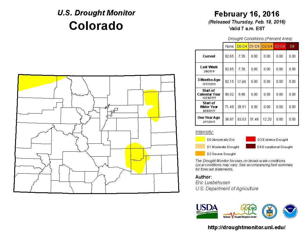
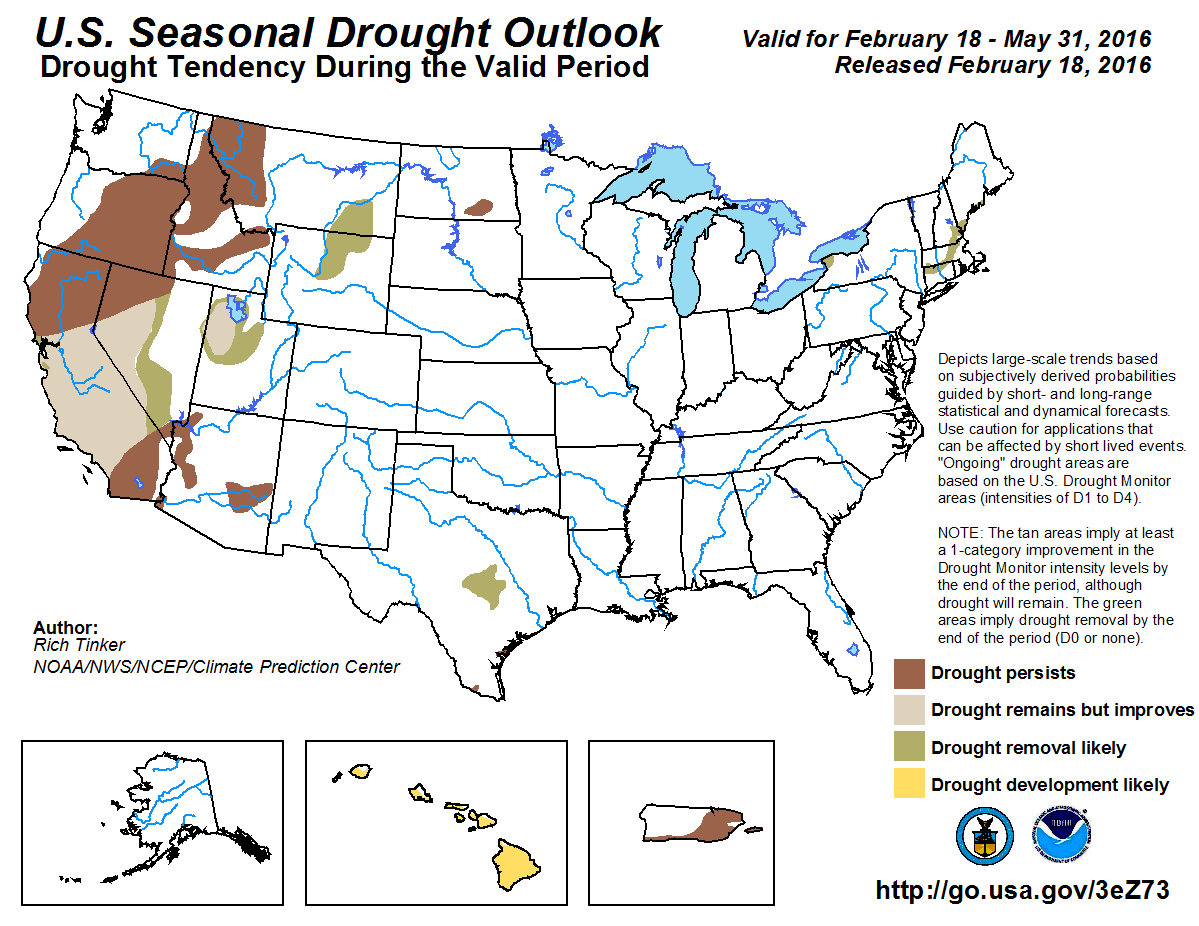

![This image was taken during the peak outflow from the Gold King Mine spill at 10:57 a.m. Aug. 5. The waste-rock dump can be seen eroding on the right. Federal investigators placed blame for the blowout squarely on engineering errors made by the Environmental Protection Agency’s-contracted company in a 132-page report released Thursday [October 22, 2015]](https://coyotegulch.blog/wp-content/uploads/2015/10/goldkingminespill1057am08052015viaepa.png)


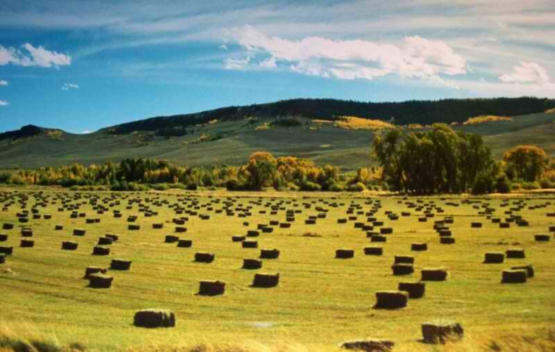


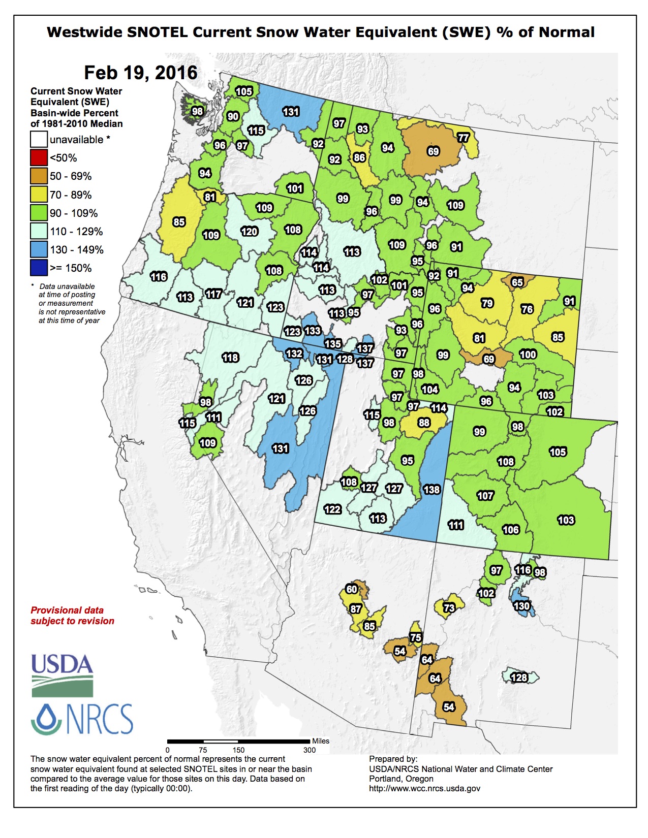
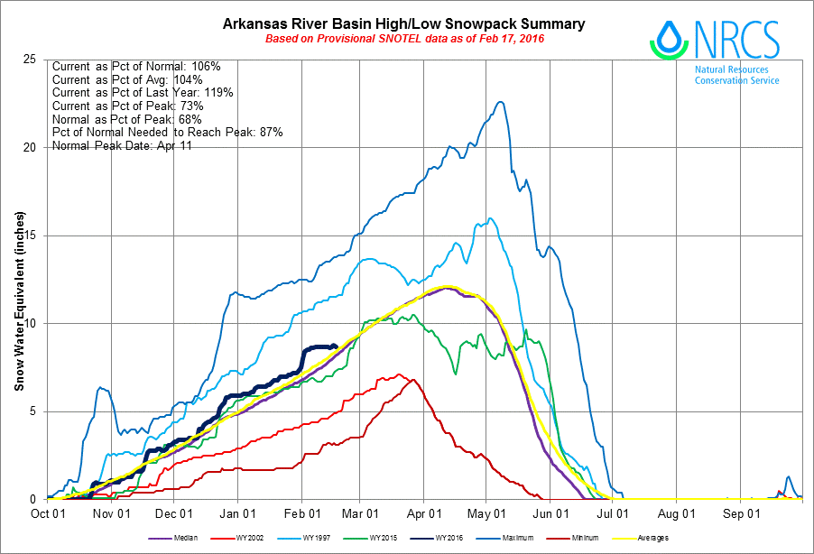
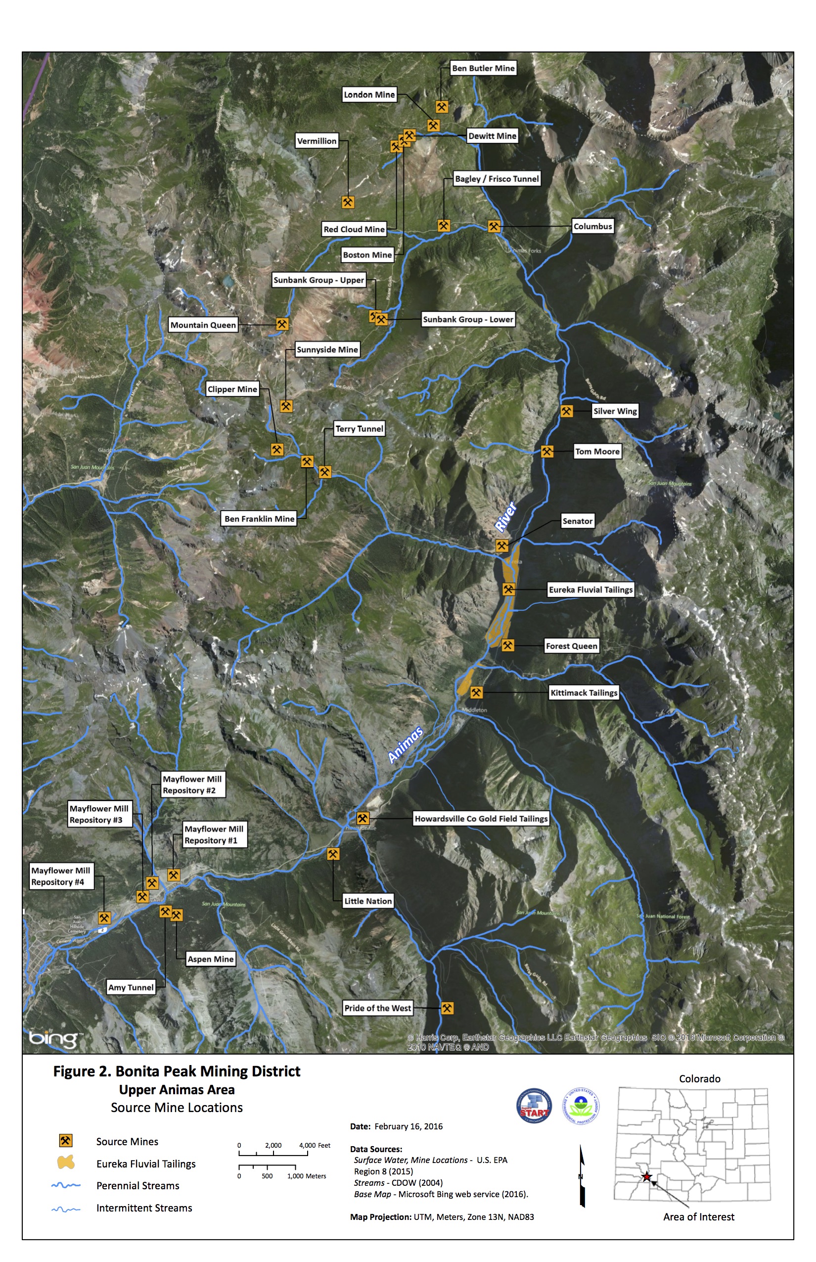

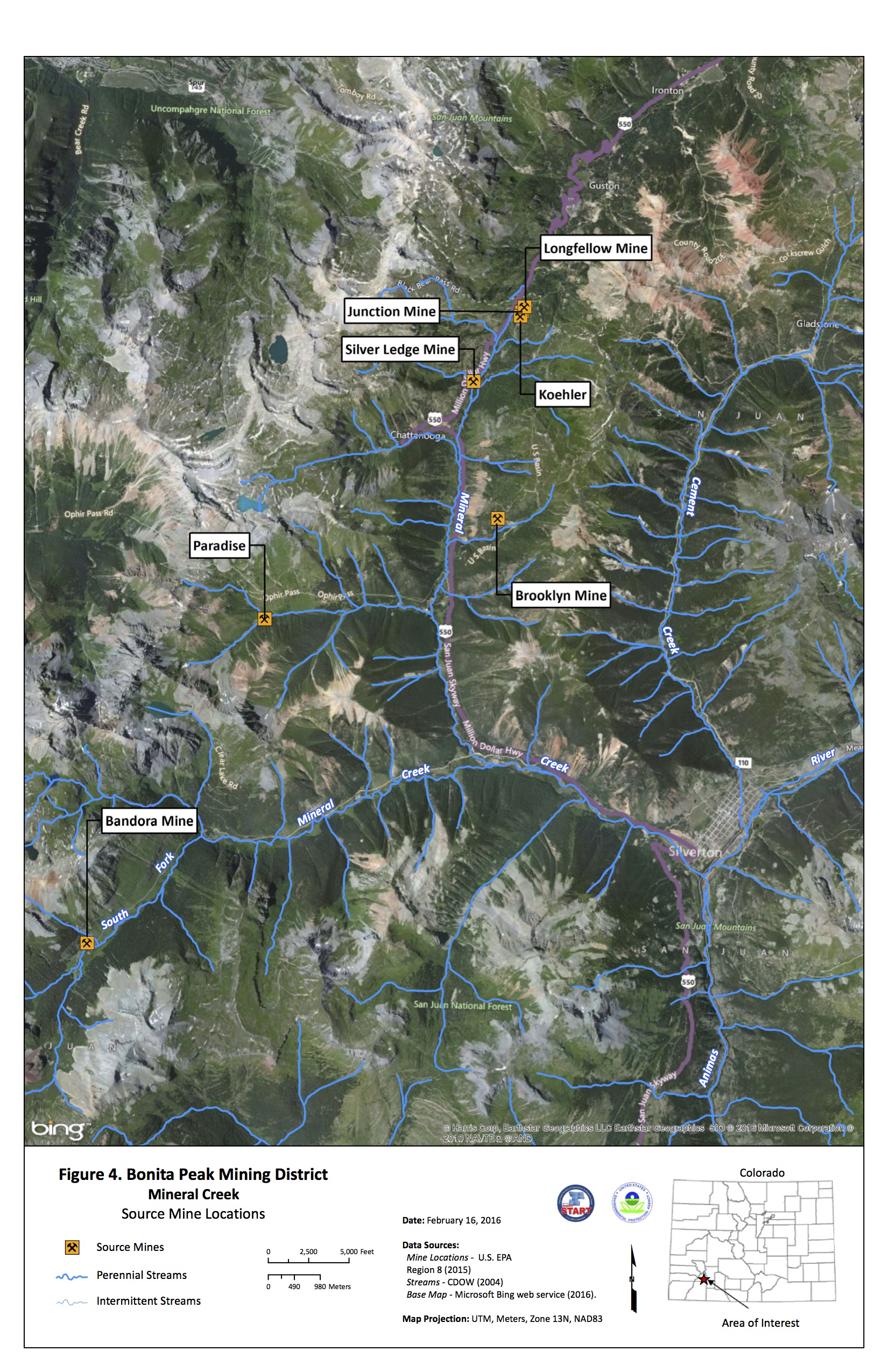

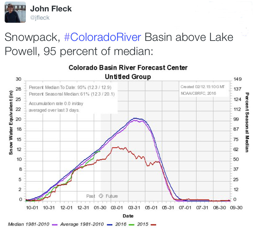


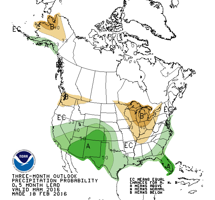


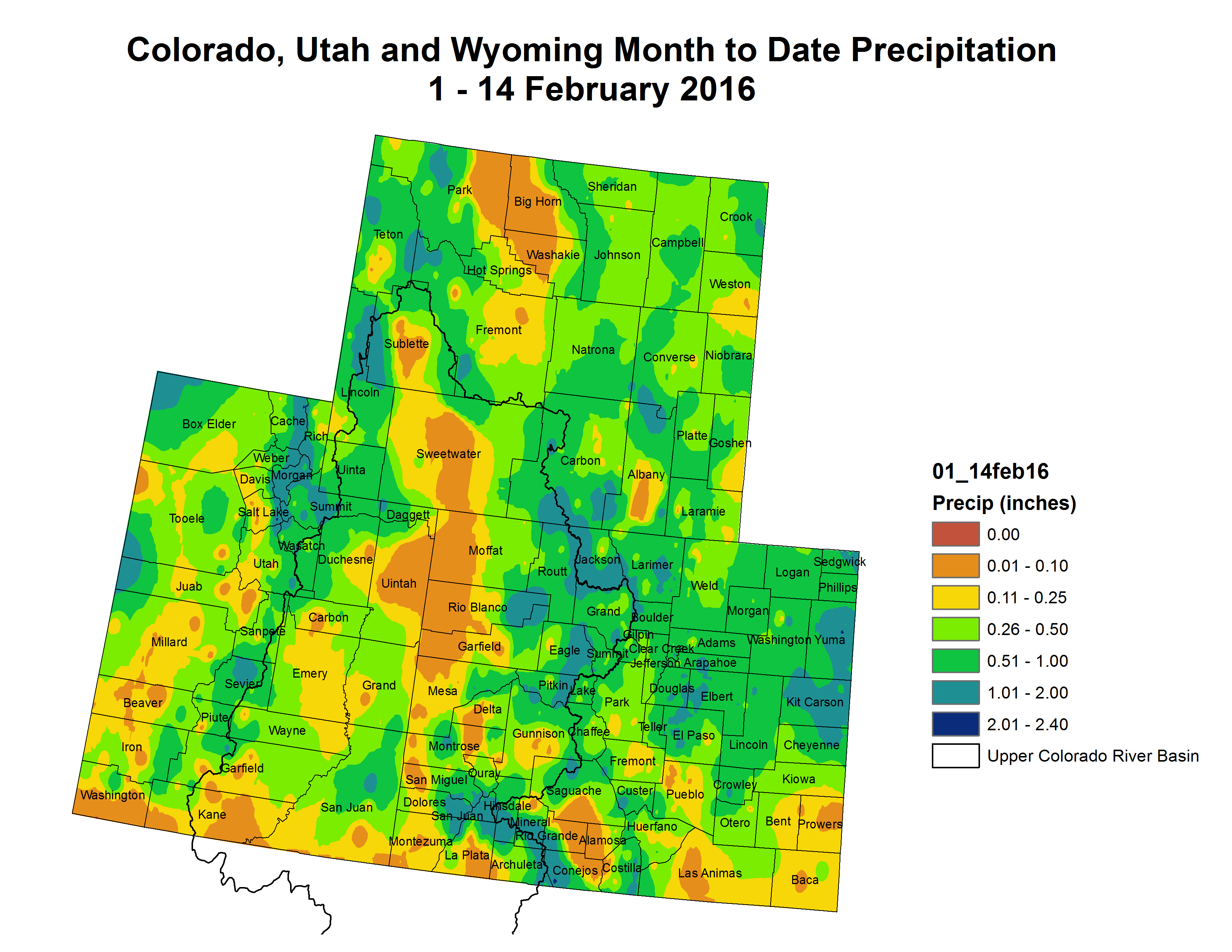


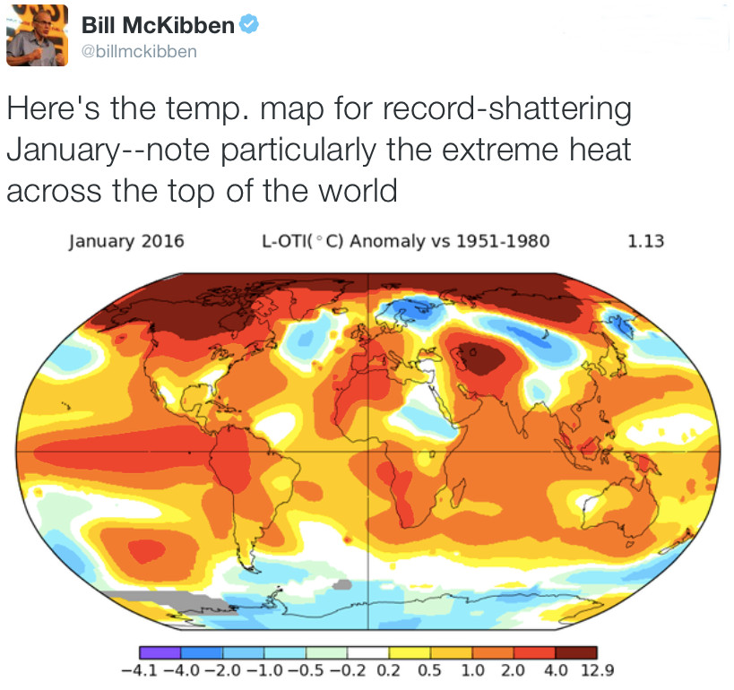


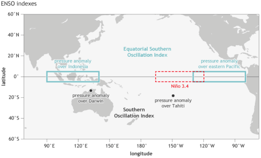


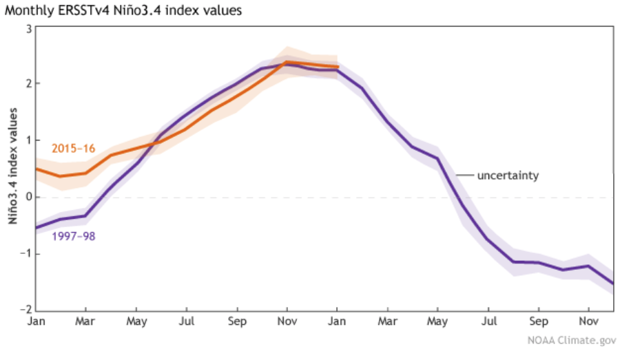
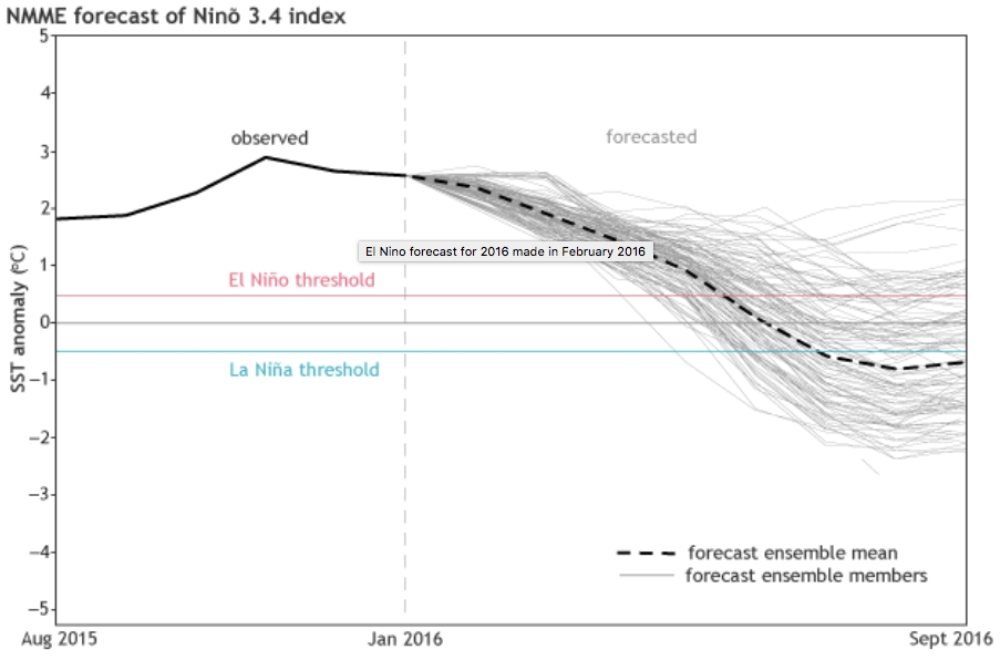


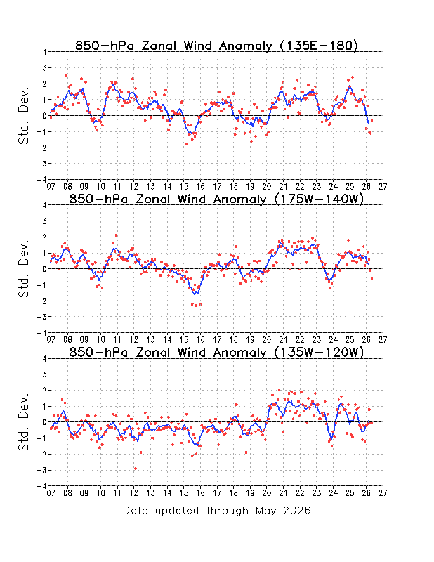