
Good timing for today’s storm, all basins have dipped below 100% of median.
From the Natural Resources Conservation Service via the Sky-Hi Daily News
The USDA Natural Resources Conservation Service (NRCS) Kremmling Field Office snow surveyors Mark Volt and Vance Fulton took the March 1st. snow survey measurements during the last days of February. Even with the recent warm weather, the survey shows that the county is in pretty good shape up high, they said.
Valley snowpack has decreased significantly during February.
Snowpack in the high elevation mountains above Middle Park now ranges from 86 percent to 125 percent of the 30-year average, with the overall average for Middle Park at 104 percent.
“Last year at this time we were at 102 percent of average,” they said.
Snow density is 28 percent, which means that for one foot of snow there is 3.4 inches of water, which is normal for March 1st.
Most of the snow courses around Middle Park have been read since the 1940s. Snow course readings are taken at the end of each month, beginning in January and continuing through April. March is historically the snowiest month and the April 1 readings are the most critical for predicting runoff and summer water supplies, as most of our high country snowpack peaks around that time.
From The Grand Junction Daily Sentinel (Dennis Webb):
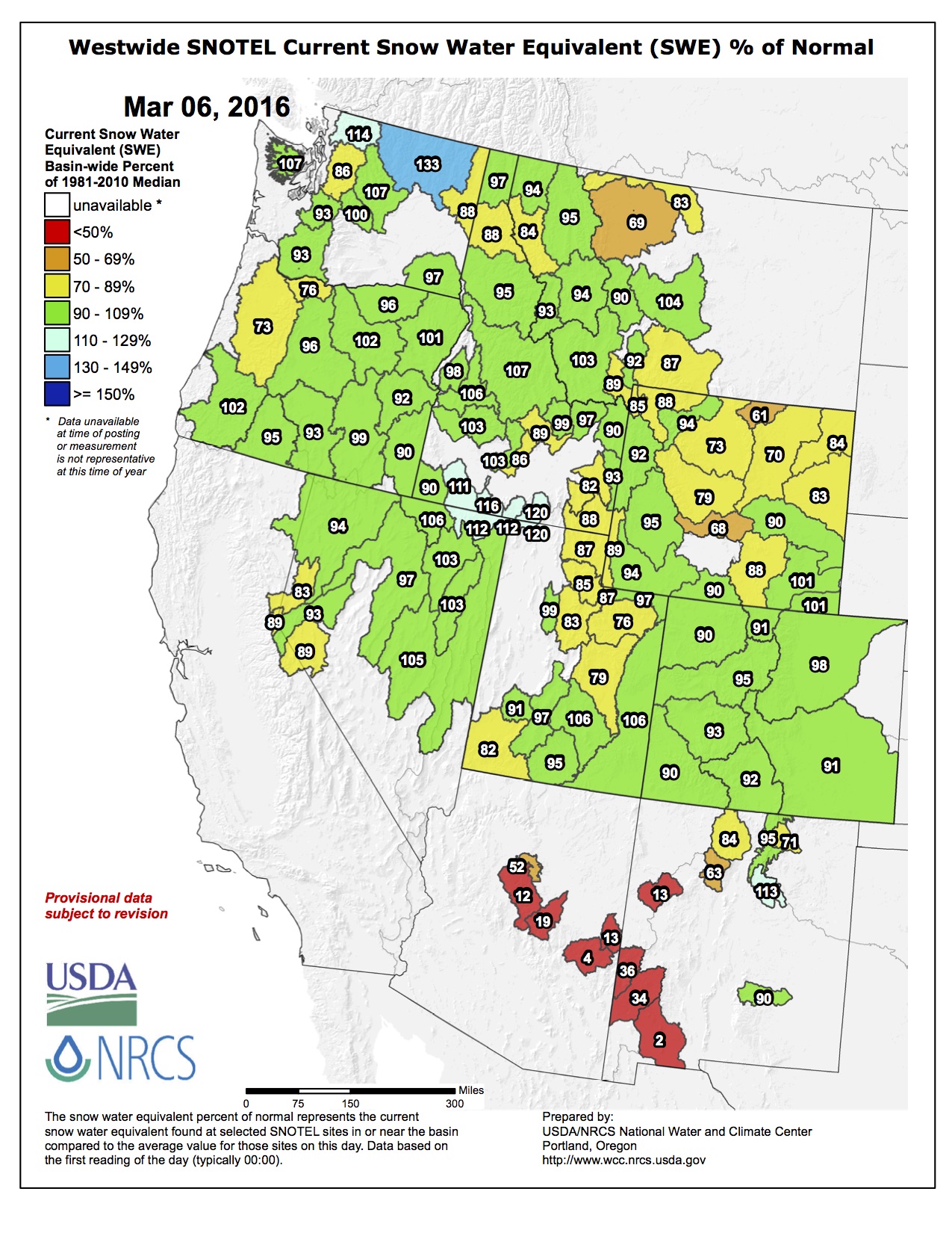
[The blue] skies and warm days have contributed to Colorado’s snowpack falling to below normal, at 98 percent of median as of Monday, according to Natural Resources Conservation Service data.
That comes after what had been a strong start for snowfall accumulation in the state in recent months. But a drier midwinter also was expected by forecasters as part of this year’s El Niño weather pattern. And the good news from a snowpack perspective is that the experts also believe the odds are that moister weather lies ahead this month and next based on past El Niño patterns.
“Right now it does look like that we are looking toward a change in (weather) pattern right around the seventh of March,” said Joe Ramey, a meteorologist with the National Weather Service in Grand Junction.
He said that in recent weeks, a ridge of high pressure west of Colorado has weakened storms coming in from the Pacific Ocean…
Painful as a weather change might sound to some, it would provide a welcome boost for the state’s water supplies. Statewide snowpack is down 19 percentage points from 117 percent as of Feb. 2. The Colorado and Gunnison river basins were respectively at 116 and 122 percent of median then, but by Monday both had fallen to exactly 100 percent of median, with the Upper Rio Grande and South Platte basins also at that amount.
The San Miguel, Dolores, Animas and San Juan basins dipped to 98 percent of median, the Yampa/White basins are at 93 percent, the North Platte is at 92 percent and the Arkansas is at 99 percent.
Colorado’s winter so far has been doing pretty well at following the script for El Niño winters, a reference to winters with weather dictated by above-normal water temperatures in the eastern equatorial Pacific Ocean. That script called for an above-average start precipitation-wise in the state, followed by a below-average period and then a wet end to the snowfall accumulation season, if a strong El Niño persists long enough, which Ramey said it’s doing.
Ramey said he had expected the dry period to arrive in January, but it showed up a little later.
“We’re still thinking that March and April overall have a tendency to be wet during especially strong El Niños,” he said…
Ramey is uncertain how long the moister trend next week may last, however, pointing to signs that the high-pressure ridge to the west could rebuild beyond March 10 and lead to a drier pattern again.
Erik Knight, a hydrologist with the U.S. Bureau of Reclamation’s Western Colorado Area Office, said he’s expecting Blue Mesa Reservoir to fill this year.
“Some of that is based on hoping the storms return in March and April,” Knight said.
He said it has helped that recent problems and maintenance work at power plants downstream from the reservoir led to reduced water releases from the reservoir and let it carry more water through the winter.
As of Feb. 1, reservoir storage across the state was at 110 percent of average. Storage was at 108 percent of average in the Upper Colorado basin and 109 percent in the Gunnison basin.
Knight said that outside of a storm at the start of February, “things have been pretty dry, not a whole lot of extra snow accumulation up there” for the month.
“Now we’re just kind of banking on El Niño producing in March and April, and if it does we’ll be good and if it doesn’t we might struggle to fill the (Blue Mesa) reservoir,” he said.
All of the snowfall in Grand Junction in February came at the start of the month, including 4 inches on Feb. 1 and small amounts on Feb. 4 and 6, Ramey said. The 4.7 inches in total amounted to above-average overall snowfall for Grand Junction for February, he said…
“Let’s keep our fingers crossed for a wet spring,” Ramey said.