
Click here to read the latest diagnostic discussion. Here’s an excerpt:
ENSO Alert System Status: El Niño Advisory
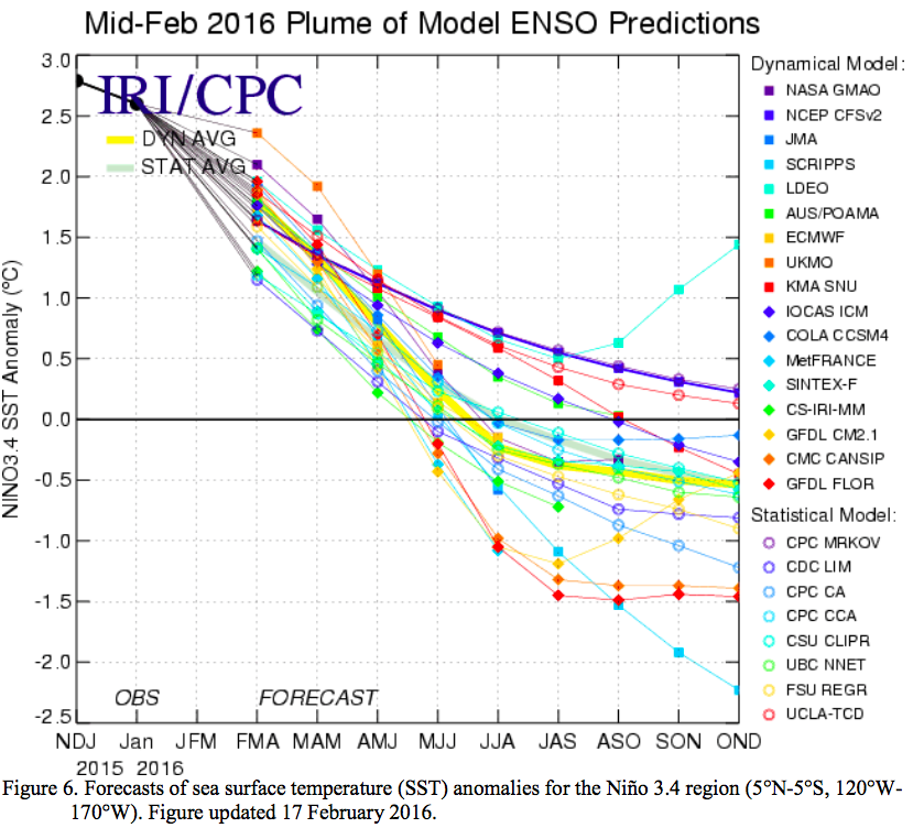
Synopsis: A transition to ENSO-neutral is likely during late Northern Hemisphere spring or early summer 2016, with close to a 50% chance for La Niña conditions to develop by the fall.
Sea surface temperature (SST) anomalies decreased across most of the central and eastern equatorial Pacific Ocean during February. The latest Niño-3.4 and Niño-3 weekly values were near 2°C, while the Niño-4 and Niño-1+2 indices were 1°C and 1.4°C respectively. The subsurface temperature anomalies in the central and eastern Pacific decreased substantially in association with the eastward shift of below-average temperatures at depth. Low-level westerly wind anomalies and upper-level easterly wind anomalies continued, but were weaker relative to January. The traditional and equatorial Southern Oscillation Index (SOI) remained strongly negative. In addition, convection was much enhanced over the central and east-central tropical Pacific and suppressed over parts of Indonesia and northern Australia. Collectively, these anomalies reflect the continuation of a strong El Niño.
All models indicate that El Niño will weaken, with a transition to ENSO-neutral likely during the late spring or early summer 2016. Thereafter, the chance of La Niña conditions increases into the fall. While there is both model and physical support for La Niña following a strong El Niño, considerable uncertainty remains. A transition to ENSO-neutral is likely during late Northern Hemisphere spring or early summer 2016, with close to a 50% chance for La Niña conditions to develop by the fall (click CPC/IRI consensus forecast for the chance of each outcome for each 3-month period).
El Niño has already produced significant global impacts and is expected to affect temperature and precipitation patterns across the United States during the upcoming months (the 3-month seasonal outlook will be updated on Thursday March 17th). The seasonal outlooks for March – May indicate an increased likelihood of above-median precipitation across the southern tier of the United States, and below-median precipitation over the Midwest and part of Pacific Northwest. Above-average temperatures are favored across the North and West, with below-average temperatures favored in the south-central region.