
Click on a thumbnail graphic to view a gallery of snowpack data from the Natural Resources Conservation Service.


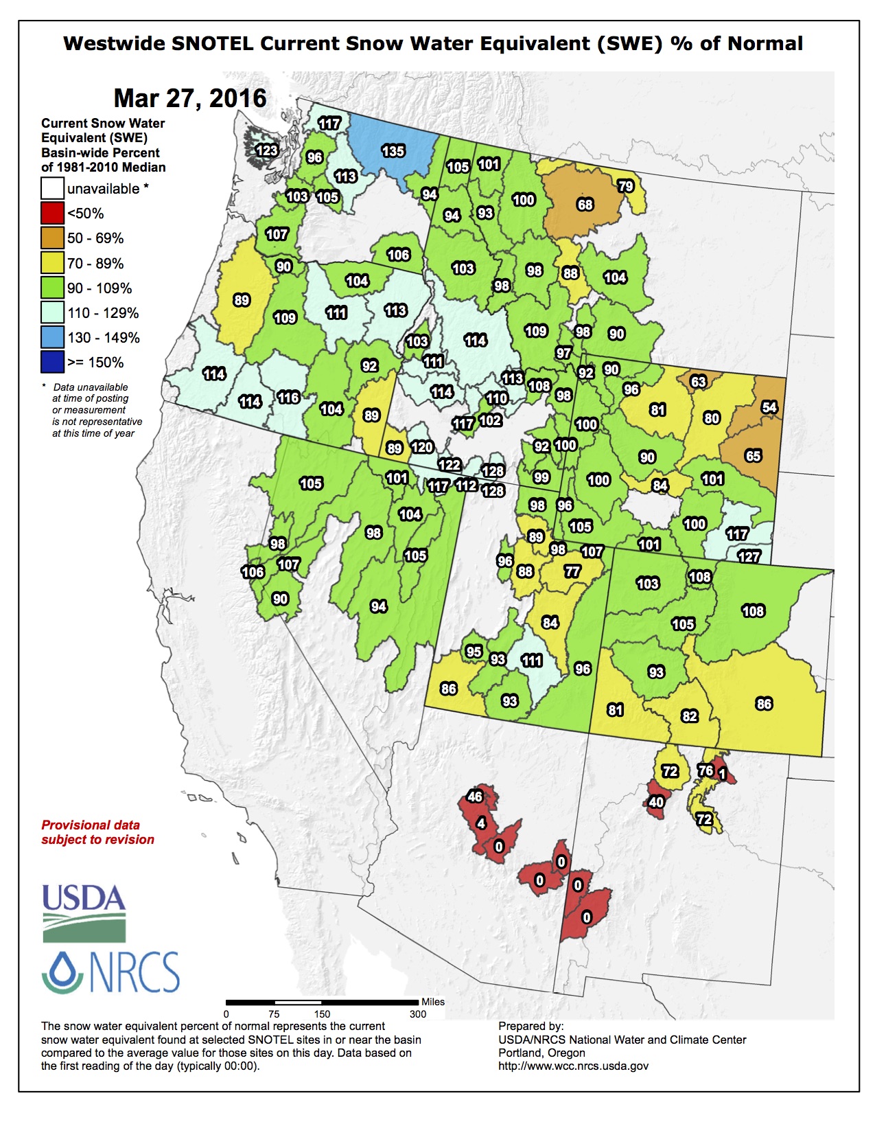
Here’s the Westwide SNOTEL map from this morning.
From The Durango Herald (Ann Butler):
Purgatory Resort reported 4 inches of snow in the last 24 hours as of Saturday afternoon.
It snowed heavily most of the day Saturday at Wolf Creek Ski Area. The area reported receiving 17 inches of snow in the previous 24 hours as of Saturday afternoon. Silverton Mountain reported 4 inches in the previous 24 hours and 18 inches in the previous 72 hours Saturday morning and hadn’t updated the report on Saturday afternoon.
“Monday night and Tuesday, there will be another storm coming through,” said Ben Moyer, a meteorologist with the Grand Junction office of the National Weather Service. “There won’t be much of anything in Durango again, but we’re predicting 9 to 10 inches in the mountains.”
From The Denver Post (Jesse Paul):
Colorado’s statewide snowpack as of Thursday remained below normal despite storms over the past several weeks that dropped feet of snow in some areas.
The Natural Resources Conservation Service showed the statewide pack at 96 percent of normal and 93 percent of the median…
The NRCS reports, however, that snowpack levels in the South Platte River basin have recovered since dipping below normal earlier this month.
The basin includes Denver and nearly all of the metro area.
The South Platte’s snowpack as of Thursday was 6 percent above normal and 5 percent above the median.
From the Glenwood Springs Post Independent (Will Grandbois):
After a wet January and dry February, snowpack in western Colorado is hovering around normal. As of Friday afternoon, gauges across the Upper Colorado River Basin were registering a snow water equivalent 102 percent of the 30-year median for the date. The Roaring Fork Watershed trailed slightly, with 90 percent of the median.
“We had that pretty big snow cycle that caused powder days and snow days at the end of January. Otherwise, it was looking a bit dry, and February was particularly dry,” said Roaring Fork Conservancy education and outreach coordinator Liza Mitchell. “Not only is it important how much more precipitation we get, but the timing of the warming can have a huge impact.”
Snowpack in the high country generally peaks around April 10, when melting outpaces snowfall and rivers begin to rise. Last year, a relatively light snow year peaked in mid-March, with a potentially bad fire season averted thanks to a cool, wet spring.
This year has already surpassed the 2015 peak, but is still well behind the robust winter of 2014.
That may seem strange to residents of Glenwood Springs, where more than 2 feet of snow fell in January – including 7 inches on Jan. 17 alone – with almost as much in December. It’s not the precipitation on the valley floor that makes the big difference, though.
“We get more melting cycles down in the lower elevations. The water supply is more in the mountains, where it’s kept longer due to temperatures,” Mitchell said. “The snowpack we have in the mountains really acts as a natural reservoir. Over the course of the year, it’s going to melt and keep our rivers running all summer long.”
As such, a better indicator might be Bison Lake on the Flat Tops, where depth and snow water equivalent are measured each March 1. This year, that came to 56 inches of snow or about 17 inches of water if you melted it down. In 2015, it was 49 inches deep with 13.4 inches of water, and in 2014, 74 inches and 20.9 inches, respectively…
Even the National Weather Service’s three-month outlook looks like a mixed bag, calling for both above-average precipitation and higher temperatures in Western Colorado.
“You don’t often see those together,” said Norv Larson, a meteorologist for the weather service in Grand Junction. “It might mean warm temperatures during the day with thunderstorms developing in the afternoon – our typical monsoon pattern.”
He shied away from linking the weather to El Niño conditions in the Pacific.
“We’re one of those areas that’s transitional, so it depends on where the pattern sets up,” he said.
From the Valley Courier (Ruth Heide):
Over the last month and a half, the Upper Rio Grande Basin snowpack has “flat lined,” according to Colorado Division of Water Resources Division 3 Engineer Craig Cotten.
Cotten told members of the Rio Grande Water Users Association during their annual meeting in Monte Vista Thursday afternoon that as of March 16, the basin snowpack sat at 85 percent of average, considerably less than it was earlier this year. In January the basin snowpack was more than 120 percent of average.
“A month and a half ago we were looking really good,” Cotten said. “We are not looking so good now, but we have got some time we could potentially get some more storms coming in.”
He said for the last three years the basin snowpack has held to a pretty similar trend, but the “flat lining” usually does not occur until March.
Cotten said the National Weather Service predicts above average precipitation for this region during April, May and June. However, “they have called for above precipitation over the last several months, and that hasn’t occurred,” he said. “We are hoping that will start to occur.”
Cotten also shared the index flow forecast for the Rio Grande, based on calculations from the Natural Resources Conservation Service (NRCS.) Their forecast for the Rio Grande this year is 620,000 acre feet. Last year the Rio Grande experienced 665,100 acre feet, and the long-term average is about 650,000 acre feet, Cotten explained.
Of the predicted 620,000 acre-foot flow on the Rio Grande, about 170,000 acre feet will have to go downstream to New Mexico and Texas to satisfy the Rio Grande Compact that Colorado has with those downstream states. Cotten said that would likely require 12-13 percent curtailment during the irrigation season. He explained that Colorado has about 6,800 acre feet of water in storage in the Rio Grande Reservoir, and if that were released, it could reduce the amount of curtailment to about 11.5 percent.
Cotten talked with the water users about the options for when and how the stored water might be released. For example, if a water year was good, it might be best to keep the water in storage. Another option is to release the water even before the irrigation season begins to wet down the system. Another option would be to hold onto the water until fall to see how the compact obligations are going and release it then if it was needed to meet the compact.
Cotten said storing compact water at the Rio Grande Reservoir rather than down at Elephant Butte Reservoir in New Mexico avoids evaporation losses. The evaporation rate of surplus compact water in Elephant Butte is about 15 percent, Cotten said.
He added that the reservoir storage at Rio Grande Reservoir is a new tool his office is determining how best to use. He welcomed ideas from the water users.