Weather and climate experts had a clear message for attendees at the Colorado Farm Show at Island Grove Regional Park on Wednesday morning: Climate change will have real effects on agriculture, politics and public controversy aside.
Brad Udall is a senior water and climate change scientist with the Colorado Water Institute at Colorado State University. He moderated a series of presentations and then a panel discussion on the subject of climate change for about 100 audience members.
“I think all of you understand that climate change is controversial, and it’s highly political,” Udall began. “But I need to tell you that within the scientific community, it is not controversial.”
The climate discussions were two of the many events on the second day of the farm show. Other presentations focused on topics ranging from the future of dairy farming to the basics of genomic testing. The farm show, which regularly brings more than 40,000 attendees during the three days concludes today.
CBS4 Denver Meteorologist Dave Aguilera opened his presentation by explaining the work of the National Ice Core Lab, located in Lakewood. Using ice cores from Antarctica, scientists observe air pockets trapped in ice from the past 800,000 years. Since the Industrial Revolution, carbon dioxide content has increased dramatically, he said.
Aguilera said he wanted to present the bare facts, without telling people what to think or demanding them to react in a certain way.
“I think when this whole thing started, we kind of went about it the wrong way. I think you can’t tell people, ‘Hey, the climate is warming up. Get rid of your car,’ ” he said.
One audience member expressed a concern that while he believes the earth is warming, the specifics of how it will affect people are uncertain. Aguilera agreed, adding people should educate themselves and others so more research can be done to clarify the full effects of climate change.
Nolan Doesken — Colorado Water Foundation for Water Education President’s Award Presentation 2011
State Climatologist Nolan Doesken followed with a discussion of Colorado’s climate. Presenting graphs of temperature changes from weather stations throughout Colorado, Doesken noted a warming trend isn’t noticeable at an isolated weather station.
But when data from weather stations across Colorado are averaged, the trend matches the national and global trends of a climate that is getting hotter. Last fall was Colorado’s hottest on record, Doesken said.
During the panel, audience members asked questions about the effect of urbanization on weather stations and how climate change will affect areas where crops can be grown.
A first-timer at the Colorado Farm Show, Rhonda Brandt, said she thought the speakers’ comments were unique. Now a resident of Cheyenne, Brandt grew up on a farm south of Akron.
She said there’s no lack of science on climate change, but a lack of conversation that isn’t muddled by politics. When it comes to the agricultural community, she believes people will prevail over politics.
“I’m confident that the farmers and ranchers will adapt as they need to,” she said. “I hope we can come up with a plan. If something major does happen, that can help the farmers and ranchers do it as a country, rather than relying on them alone. Our food supply depends on it.”
Pond on the Garcia Ranch via Rio Grande Headwaters Land Trust
From Great Outdoors Colorado (Rosemary Dempsey) via The Crestone Eagle:
The Great Outdoors Colorado (GOCO) Board awarded three grants totaling more than $1.4 million to projects across the San Luis Valley. San Luis Valley Inspire, a valley-wide coalition breaking down barriers for kids to get outside, received $1 million in funding as part of the GOCO Inspire Initiative; Rio Grande Headwaters Land Trust (RiGHT) received a $376,500 grant to permanently conserve the La Garita Creek Ranch near Del Norte; and Colorado Parks and Wildlife (CPW) received a $25,000 habitat restoration grant for Rio Grande State Wildlife Area.
The $1 million grant is part of GOCO’s Inspire Initiative, which will invest in places, programs, and pathways to get kids outside in communities across the state. This innovative framework is being looked at as a national model, and each coalition’s approach to the unique challenges of their community will serve as examples to other rural, urban, suburban, or mountain communities across the country.
Youth have led the charge for the San Luis Valley Inspire coalition; this funding will put their plans into action over the next three years. San Luis Valley Inspire will put GOCO funding to work in Antonito, Creede and Saguache, building the Antonito Outdoor Education Center and investing in the creation of the Antonito Adventure Program, improving connections along Creede’s Willow Creek Corridor, the Headwaters Youth Conservation Corps, the Saguache Backyard to Backcountry Program, and the Saguache Youth Conservation Corps.
RiGHT’s grant for La Garita Creek Ranch was part of GOCO’s open space grant program, which funds public and private land conservation. Projects sustain local agriculture and economies, give outdoor recreationists a place to play (or simply enjoy the view), protect wildlife habitat, and safeguard the state’s water supply.
La Garita Creek Ranch is a 460-acre guest ranch outside of Del Norte near Penitente Canyon, an international climbing, hiking, and mountain biking destination. The ranch is also adjacent to Bureau of Land Management (BLM) land and the Rio Grande National Forest.
Conserving La Garita will protect critical water access and habitat for a variety of wildlife species as well as Ute pictographs and other archaeological evidence of early Native Americans. The conservation project will also create new climbing and bouldering access.
CPW’s grant is part of GOCO’s habitat restoration grant program. In 2016, GOCO doubled funding for the program, which restores habitat through projects that remove invasive plant species, protect Colorado’s water supply, mitigate fire fuels, and perform other critical restoration work.
Restoration of the Rio Grande in Rio Grande State Wildlife Area will protect water infrastructure, local agriculture, and wetlands that support threatened and endangered amphibians, fish, birds, and mammals.
To date, GOCO has invested $42 million in San Luis Valley projects and has conserved more than 90,000 acres of land in the valley. GOCO funding has supported Alamosa’s ice rink and Rio Grande Farm Park, Faith Hinkley Memorial Park in Monte Vista, and Center’s Town Park, among other projects.
Great Outdoors Colorado (GOCO) invests a portion of Colorado Lottery proceeds to help preserve and enhance the state’s parks, trails, wildlife, rivers, and open spaces. GOCO’s independent board awards competitive grants to local governments and land trusts, and makes investments through Colorado Parks and Wildlife. Created when voters approved a Constitutional Amendment in 1992, GOCO has since funded more than 4,800 projects in urban and rural areas in all 64 counties without any tax dollar support. Visit GOCO.org for more information.
NASA will host a media day at 9:30 a.m. MST on Feb. 13 to highlight a field campaign designed to advance new remote-sensing techniques to measure the amount of water held in snow, a key factor in calculating water supplies in many parts of the world.
The event will be held at Peterson Air Force Base in Colorado Springs. NASA’s SnowEx project, which is a multi-year campaign to test a variety of sensors and techniques to improve measurements of snow over different terrains, begins in February and will collect a variety of airborne and ground-based measurements. The research team includes more than 100 scientists from universities and agencies across the United States, Europe and Canada.
Reporters will have the opportunity to interview scientists, pilots, and mission managers and tour the Naval Research Laboratory P-3 Orion aircraft that will be used in the campaign. The P-3 is operated by the Scientific Development Squadron ONE, based at Naval Air Station Patuxent River in Maryland.
Media interested in participating in the event should contact Rani Gran via at rani.c.gran@nasa.gov no later than 1 p.m. on Feb. 10. Attendees will need a driver’s license, vehicle registration and proof of insurance to enter the base. The date of the event is subject to change based on flight schedules.
Media interested in a separate escorted trip in February to SnowEx ground sites near Grand Mesa, Colorado, should contact Jennifer Hayes of the U.S. Forest Service at 970-498-1365 or jenniferhayes@fs.fed.us.
More than one-sixth of the world’s population relies on seasonal snow and glaciers for water. As much as three quarters of the water used in the western United States comes from snow. For decades, satellites have measured the area covered by snow but they cannot consistently measure how much water is contained in the snow over all terrains. Better measurements of snow are of significant interest to managers of fresh water availability, natural hazards, winter-dependent industries, and ecosystem impacts.
SnowEx is sponsored by the Terrestrial Hydrology Program in NASA’s Earth Science Division in Washington, and managed by the agency’s Goddard Space Flight Center in Greenbelt, Maryland. The U.S. Forest Service is leading the ground campaign in Grand Mesa and Senator Beck Basin, both in Colorado. A list of SnowEx partners is available online.
NASA collects data from space, air, land and sea to increase our understanding of our home planet, improve lives and safeguard our future. For more information about NASA’s Earth science programs, visit:
A group of citizens during a site visit in September standing in the meadow near the Maroon Bells that would be flooded by a potential 155-foot-tall dam across Maroon Creek. State officials have recently questioned the city of Aspen’s claims to extend conditional water rights for the dam, and another one on Castle Creek, for another six years.
City of Aspen also signs flurry of contracts with water professionals to study reservoirs and Aspen’s water storage needs
GLENWOOD SPRINGS – After conferring on the city of Aspen’s applications to extend its conditional water rights tied to potential dams and reservoirs on Maroon and Castle creeks, the division engineer and the water court referee in Division 5 together have raised substantial questions about the two applications.
The two state officials, based in Glenwood Springs, said recently in two required summary of consultations that the city “must demonstrate that it will secure permits and land use approvals that are necessary to apply the subject water rights to beneficial use.”
It also said the city needs to show that it “will complete the appropriations within a reasonable time,” that the city has to show that “a specific plan is in place to develop the subject water rights” and that it is “not speculating with the subject water rights.”
Alan Martellaro, the division engineer in Division 5, signed the two summary of consultations on Jan. 23, one regarding Maroon Creek Reservoir and one regarding Castle Creek Reservoir. They are identical save for the names of the reservoirs and differing case numbers.
Martellaro wrote in both reports, “I cannot recommend approval of this application” until the concerns cited in the reports are addressed.
And the reports say that the “state and division engineers ask that the issues discussed in this consultation be addressed prior to granting any findings of diligence” for either the Maroon Creek or Castle Creek reservoirs.
The city filed two “due diligence” applications on Oct. 31, one for Maroon Creek Reservoir and one for Castle Creek Reservoir. Aspen is seeking to extend the conditional water storage rights for another six years. The rights were appropriated in 1965 and adjudicated in 1971.
The city has filed diligence applications for the reservoirs eight prior times, in 1972, 1977, 1981, 1985, 1989, 1995, 2002 and 2009, and each time has been awarded a new diligence decree for the conditional rights.
The conditional rights, as currently decreed, cannot be made absolute unless the city builds a dam 155 feet tall and an estimated 1,280 feet wide across Maroon Creek, within view of the Maroon Bells, and a dam 170 feet tall and an estimated 1,220 feet wide across upper Castle Creek two miles below Ashcroft.
The Maroon Creek Reservoir would hold 4,567 acre-feet of water and flood 85 acres of land, and the Castle Creek Reservoir would hold 9,062 acre-feet of water and flood 120 acres of land. Water in both reservoirs would flood some land within the wilderness boundary.
Members of the City Council indicated this fall said they are loath to actually build the dams, but still want to maintain the water rights for future potential use.
However, the language in the applications the city filed with water court in October indicates the city intends to build the dams some day.
The city told the court the two reservoirs are “part of Aspen’s integrated water supply system” and are “part of Aspen’s long-range plan to maintain a water supply to meet current and future demand.”
The city also said it has “steadily applied effort to complete the appropriation” of the water rights for the reservoirs and that it has done so “in a reasonably expedient and efficient manner under all the facts and circumstances.”
But the consultation reports in the two cases show that state water officials are skeptical about the city’s claims.
Aspen “is not entitled to an exemption from the anti-speculation doctrine” and “it cannot assert issue or claim preclusion to avoid the ‘can and will’ and the ‘anti-speculation’ doctrines,” the reports say.
The reports also observe that the city lists “other beneficial uses, both consumptive and non consumptive” in its water right application, in addition to storage. And as such, the city “must explain what these ‘other’ uses are or they should be cancelled by the court as speculative.”
Many of the points raised in the consultation reports were also raised by some of the 10 opponents to the city’s applications in their statements of opposition.
The United States of America, on behalf of the U.S. Forest Service, and Pitkin County are among the 10 parties that have filed statements of opposition in the two cases.
In addition to the two governments, four environmental organizations and four private-property owners also filed statements of opposition in the cases.
Attorneys at the U.S. Justice Department told the court the city “cannot show that it can and will” complete the two reservoirs “within a reasonable time” because both potential reservoirs would flood portions of the Maroon Bells-Snowmass Wilderness.
And Pitkin County told the court the city “appears to be speculating with no reasonable demonstration of need” for the reservoirs.
It is standard procedure in Division 5 water court for applicants to eventually file a “response to the summary of consultation.”
Orange tape marks the location of a potential 155-foot-tall dam across upper Maroon Creek near the Maroon Bells. The city of Aspen has filed to extend its conditional water rights tied to the potential dam and reservoir, as well as another dam on Castle Creek, but the state division engineer and water court referee in Division 5 have challenged the city’s claims.
Relevance of consultations
Under Colorado law, the water court referee and the division engineer are required to review all applications to water court.
The law says the officials are to “make such investigations as are necessary to determine whether or not the statements in the application and statements of opposition are true and to become fully advised with respect to the subject matter of the applications and statements of opposition.”
The law then requires that the “engineer consulted shall file a report” within 35 days.
But it is sometimes hard to discern how much weight such a report carries in the water court process.
Holly Strablizky, who recently stepped down from her position as water court referee in Division 5 after almost seven years, said last week during a presentation at the Colorado Water Congress that as water referee she “really tried hard and I know our division engineer tried really hard as well … to use the consultation process to get a better product out there.”
Strablizky, who is now an assistant county attorney for Eagle County, said the engineer and the referee also need to look at a given application from a statewide perspective.
“The constitution really says that we as the water court need to think not only of the parties that are in the cases, but the people of Colorado,” Strablizky said.
She also praised the use of the water court referee process, where parties are encouraged to settle their differences.
“I think it relieves pressure of hard deadlines and it allows for thoughtful and creative settlement discussions,” Strablizky said of the referee period, which usually lasts 12 to 18 months. “And it creates that opportunity for concise, and understandable, proposed decrees.”
The parties in Aspen’s two conditional water rights cases are set to have a joint initial telephone conference with the new water court referee, Susan Ryan, on Feb. 9.
A detail of a map of the potential Castle Creek Reservoir, prepared by Wilderness Workshop and based on a map filed by the city with the state in 1965. The dam would be 170 feet tall and span 1,220 feet across the valley.
Community water planning
In addition to participating in the two water rights cases regarding due diligence, the city is also launching a community-based water planning effort, and has signed a flurry of contracts to study its storage needs and better understand at least the potential Castle Creek Reservoir location.
It also not retreating from its call to build a new dam somewhere in the future.
In a memo about a Jan. 31 work session, city staff wrote, “Without water storage, Aspen’s water supply for households and businesses will be threatened.”
To move its new water-planning process forward the city has entered into a contract with the Consensus Building Institute of Cambridge, Mass., to develop a “convening assessment” that will lead to a “collaborative process,” according to the staff memo.
“It is critical to use an effective community-based approach in order to leverage the expertise in the community and develop a long-term water supply plan with the greatest chance of success to secure Aspen’s water future,” the city’s memo states.
The convening assessment is expected to take two months and then a collaborative process will begin by summer.
According to the memo for the work session, which was written by Margaret Medellin, the city’s utilities portfolio manager, Aspen has also entered into a contract with Headwaters Inc. in South Jordan, Utah, to perform a “preliminary review of risks in Aspen’s demand and supply” of water through 2065.
The city has also signed a contract with Sopris Engineering of Carbondale “to update surveying for Castle Creek Reservoir” and it has “met with dam and reservoir expert, Terry Arnold, to review certain existing geological data.”
A series of test bores in 1971 by the Bureau of Reclamation found 142 feet of loose rock and sand under the proposed Castle Creek dam site and that it was also on an unstable fault zone.
The city also signed a contract in January with Deere and Ault Consultants of Longmont for a feasibility study on the use of storing water underground, including in old mine shafts, which are plentiful under downtown Aspen.
The consulting firm says on its website that it is “a specialized civil engineering firm focused on water resources, geotechnical, dam, slurry wall, tunnel, and mine reclamation projects.”
And the city memo notes that “on January 26, 2017, consultants Don Deere and Victor DeWolf met with staff and performed on site investigative tour of local mines.”
The city also signed a contract with Carollo Engineers, a national engineering firm focused on water projects, to help it gain approval from the Colorado Dept. of Public Health and Environment to use treated effluent from the Aspen sewage treatment plant.
The city has been working on this reuse project for several years and plans to pump water up from the treatment plant for a number of uses, including watering the city golf course and for snowmaking.
The Jan. 27 staff memo closed by saying “staff is developing a project specific budget that will include estimates of the costs of community facilitation” as well “identified supporting engineering consultant and expert services, legal expenses and staffing.”
The budget details are to be presented at a follow-up work session.
Editor’s note: Aspen Journalism, the Aspen Daily News and Coyote Gulch are collaborating on coverage of rivers and water. The Daily News published a version of this story on Monday, Jan. 30, 2017.
Click here to go to the NASA website for all the inside skinny. Here’s an excerpt:
The snow-capped mountains of Colorado and Utah contain trillions of gallons of water stored in the form of snow. Meltwater from this snow will eventually flow into the Colorado River, delivering much needed water to seven Western states and 33 million people. Accurately predicting water from snowmelt is critical to the region, and Earth-observing satellites can help. Credits: iStock
When Michelle Stokes and Stacie Bender look out across the snow-capped mountains of Utah and Colorado, they see more than just a majestic landscape. They see millions of gallons of water that will eventually flow into the Colorado River.
The water stored as snowpack there will make its way to some 33 million people across seven western states, irrigating acres of lettuce, fruits and nuts in California, generating enormous amounts of electricity and ultimately flowing from taps in seven states. For a few of these sun-drenched states, snowfall (and its subsequent melt) provides up to 80 percent of the annual precipitation, which is ultimately used for drinking, farming, recreation and power generation. While it’s important for water managers in these states to know the amount of water they can expect from snowmelt, it’s every bit as important for them to know when to expect it.
In the Flow
As hydrologists at the Colorado Basin River Forecast Center, Stokes and Bender do just that, by providing stream flow forecasts for watersheds within the Colorado River Basin and the region. This Basin includes some of the most parched land in the United States. As a result, so much water is taken out for human uses and so little put back in that the river routinely runs dry before it ever reaches its mouth at the Gulf of California in Mexico. With such a scarce resource, every drop counts.
Water for drinking, agriculture, recreation and even power generation also comes from the Colorado River Basin. And of course fish, birds and numerous other species rely on this water too. Credits: NASA
“The forecasts we get from the center provide crucial information for managing our water resources and reservoir facilities,” said Dave Kanzer, a deputy chief engineer for Colorado River District in Glenwood Springs, Colorado. “The water supply forecasts are critical. If we receive less water than the forecasts predict, we won’t have enough saved in the reservoirs to keep the river flowing throughout the irrigation demand season. Conversely, if we receive more than forecasted, we could have to release extra water, without causing damaging floods.”
Aware of the importance of accuracy, the center inputs numerous readings into a complex computer program that uses that information to generate its forecasts. Prior to 2011, those inputs came solely from ground-based sensors and direct observations from staff. However, 2009 served as a turning point when massive storms blew what seemed to be unprecedented amounts of dust from the Colorado plateau onto the pristine white snow in the Rocky Mountains. Under a thick blanket of dust, the normally reflective white snow absorbed more of the sun’s energy, and the snowpack melted at a much faster rate than expected during the runoff season.
“We found that really dusty conditions increase the rate of snowmelt about as much as raising the temperature by 1 to 3 degrees Fahrenheit,” explained Bender. “It became very clear that we had to identify a more precise way of measuring dust on snow.”
resh white snow can reflect up to 90 percent of sunlight, but with dust on the snow more light is absorbed and the snowpack melts at a much higher rate during runoff season, so measuring the dust can help better forecast water flow. NASA satellites Terra (shown in this artist’s concept) and Aqua can detect dust in the snow to estimate the additional heat-producing energy absorbed by the snowpack, which is factored into the water runoff forecasting model. Credits: NASA
While measuring dust might seem like the time to zoom in, Stokes and Bender actually had to zoom out—way out. As they soon discovered, the answer was orbiting high above the Rocky Mountains up in space.
Measuring Up
Tom Painter has spent his fair share of time among the pristine peaks of the Rockies. As a research scientist at NASA’s Jet Propulsion Laboratory in Pasadena, California, he’s been studying dust and snowpack for years. In 2011, Painter and his colleagues signed on to help Stokes and Bender improve streamflow forecasts by harnessing the power of Earth observations from space; a fruitful collaboration was born.
With NASA’s help, the center began to incorporate two sets of remotely sensed data into its forecasting model. The first set gave them a more accurate reading of where the snow was located, while the second provided them with a clearer picture of the snowpack’s surface conditions and specifically the amount of additional sunlight absorbed by dust contained in the snowpack.
“When we first started using remote sensing data, everything shifted,” said Bender. “In fact, our research shows that using remote sensing data reduces the error by about 70 percent in some watersheds. It enables us to predict the stream flow timing much better than what our system did before.”
With more accurate forecasts, water managers are now able to make better decisions about when and how much water to store and/or release into the Colorado River basin—decisions that can have a dramatic impact on the lives and well-being of people and wildlife.
With this information, water managers can make better allocation decisions pertaining to drinking water, food, energy and ecosystem needs. Credits: iStock
“We know how crucial water is to farmers and communities,” said Kanzer. “At the same time, without enough water flowing through the rivers, entire generations of endangered fishes could be put at risk. The more accurate the forecasts are, the better equipped we are to strike that balance.”
Pooling Resources
As water management becomes increasingly vital due to population growth and recurring droughts, the connection between Earth-observing satellite data and those working hands-on with that information is increasingly critical. “Collaboration is essential to finding answers and providing information that benefits our communities,” said Painter. “With these partnerships, we’re able to leverage enhanced knowledge of planet Earth to advance science, while simultaneously helping to create healthier livelihoods, economies, and environments. And these partnerships help us identify new questions and important areas for research.”
By working together to use NASA’s satellite data, Painter and the Colorado Basin River Forecast Center ensure that more than 33 million people have a more secure water supply and don’t have to worry about consulting a forecast before turning on the faucet.
About the Science
Despite the importance of snowpack albedo—the proportion of light that is reflected versus absorbed—in controlling snowpack runoff, snowpack albedo has been unquantified for much of the United States. To measure it, Painter’s team at NASA detects light absorbing impurities (such as dust) on the snow with its MODIS (Moderate Resolution Imaging Spectroradiometer) instruments aboard two satellites: Terra and Aqua. NASA uses these data to estimate the additional energy absorbed by the snowpack, an essential input for understanding snowpack energy-balance dynamics. Growing from this effort, Painter’s team has developed the Airborne Snow Observatory, which assembles the combination of albedo and snow water equivalent, the two most important controls on timing and magnitude of snowmelt runoff.
View of runoff, also called nonpoint source pollution, from a farm field in Iowa during a rain storm. Topsoil as well as farm fertilizers and other potential pollutants run off unprotected farm fields when heavy rains occur. (Credit: Lynn Betts/U.S. Department of Agriculture, Natural Resources Conservation Service/Wikimedia Commons)
Morgan Conservation District’s 62nd annual meeting will be held on February 9th.
It will be held at the Fort Morgan Home Plate Restaurant, 19873 U.S. Hwy. 34. Breakfast will be at 8 a.m. and the meeting will start at 9 a.m. The cost of the meeting will be $25 in advance, and that will cover the annual meeting, annual membership in Morgan Conservation District, and free breakfast that morning.
If you do not RSVP in advance, and show up on the day of the meeting, please be advised that the cost will be the same, however breakfast will not be free, due to our needing to order the food in advance. Our keynote speakers, Bill Hammerich and Andrew Neuhart.
Bill Hammerich has served as the CEO of Colorado Livestock Association (CLA) for the past fourteen years. He grew up on a cattle and farming operation in Western Colorado and he attended CSU where he graduated with a degree in Agricultural Economics. Following graduation, he began working with Monfort of Colorado, then Farr Feeders and was with the Sparks Companies before joining CLA in 2002.
His time spent in the cattle feeding industry provided him not only with an understanding of how to feed cattle, but also the importance of protecting and sustaining the environment in which one operates.
Bill and his wife Sabrina live in Severance, Colorado and have two grown children, Justin and Jessica, and four grandsons.
Andrew Neuhart completed both a B.S. in Natural Resource Management and an M.S. in Watershed Science at CSU. After spending two years assisting in precision farming studies in the San Luis Valley for the USDA Soil, Plant and Nutrient Research team, Andrew went to work for the State of Colorado’s Water Quality Control Division. For 9 years with the WQCD, Andrew led a Permitting Unit for discharge permits under the Clean Water Act, for both industrial and domestic wastewater treatment facilities. Working for Brown and Caldwell over the last 4 years, Andrew assists clients with regulatory issues under the Clean Water Act, and has been working with the Ag Task Force, part of the Colorado Monitoring Framework, to get the word out regarding nutrient regulations and their impacts to agricultural operations.
Mr. Hammerich and Mr. Neuhart will be speaking about Regulation 85.
Regulation 85 establishes requirements for organizations holding a NPDES permit and with the potential to discharge either nitrogen or phosphorus to begin planning for nutrient treatment based on treatment technology and monitoring both effluents and streams for nitrogen and phosphorus.
The data from these efforts is designed to better characterize nutrient sources, characterize nutrient conditions and effects around the state and to help inform future regulatory decisions regarding nutrients. Please come to the meeting and learn more from our very knowledgeable keynote speakers!
Please RSVP as soon as possible to Angela at morganconservationdistrict@gmail.com or call 970-427-3362. Space is limited.
Click here to read the report. Here’s an excerpt (Christine G. Rasmussen and Patrick B. Shafroth):
Strategic planning is increasingly recognized as necessary for providing the greatest possible conservation benefits for restoration efforts. Rigorous, science-based resource assessment, combined with acknowledgement of broader basin trends, provides a solid foundation for determining effective projects. It is equally important that methods used to prioritize conservation investments are simple and practical enough that they can be implemented in a timely manner and by a variety of resource managers. With the help of local and regional natural resource professionals, we have developed a broad-scale, spatially-explicit assessment of 146 miles (~20,000 acres) of the Colorado River mainstem in Grand and San Juan Counties, Utah that will function as the basis for a systematic, practical approach to conservation planning and riparian restoration prioritization. For the assessment we have:
1) acquired, modified or created spatial datasets of Colorado River bottomland conditions; 2) synthesized those datasets into habitat suitability models and estimates of natural recovery potential, fire risk and relative cost; 3) investigated and described dominant ecosystem trends and human uses; and 4) suggested site selection and prioritization approaches. Partner organizations (The Nature Conservancy, National Park Service, Bureau of Land Management and Utah Forestry Fire and State Lands) are using the assessment and datasets to identify and prioritize a suite of restoration actions to increase ecosystem resilience and improve habitat for bottomland species. Primary datasets include maps of bottomland cover types, bottomland extent, maps of areas inundated during high and low flow events, as well as locations of campgrounds, roads, fires, invasive vegetation treatment areas and other features.
Assessment of conditions and trends in the project area entailed: 1) assemblage of existing data on geology, changes in stream flow, and predictions of future conditions; 2) identification of fish and wildlife species present and grouping species into Conservation Elements (CEs) based on habitat needs; and 3) acquisition, review and creation of spatial datasets characterizing vegetation, fluvial geomorphic and human features within the bottomland. Interpretation of aerial imagery and assimilation of pre-existing spatial data were central to our efforts in characterizing resource conditions. Detailed maps of vegetation and channel habitat features in the project area were generated from true color, high resolution (0.3 m) imagery flown September 16, 2010. We also mapped channel habitat features at high flow on 1.0-m resolution, publicly available, true color imagery. We obtained additional layers such as land ownership, roads, fire history, non-native vegetation treatment areas, and recreational use features from public sources and project partners.
FromThe Grand Junction Daily Sentinel (Dennis Webb):
A new report published by Colorado Mesa University aims to help in planning and prioritizing river restoration projects along 146 miles of the Colorado River from the Colorado-Utah border to the upper reaches of Lake Powell.
“Conservation Planning for the Colorado River in Utah” is the third in a series of scientific and technical reports issued through CMU’s Ruth Powell Hutchins Water Center.
The river restoration report was written by Patrick Shafroth of the USGS and Christine Rasmussen of EcoMainstream Contracting in Durango.
It’s expected that federal and state agencies, conservation groups and others will be able to use the assessment and datasets to identify and prioritize projects to improve wildlife habitat and make the river’s ecosystems more resilient. Already, such entities have been involved in an effort called the Colorado River Conservation Planning Project…
The datasets include maps of existing habitats, areas inundated during high and low flows, and locations of campgrounds, roads, invasive vegetation treatment areas and other features.
The report says that “detailed resource maps can be used in project planning to help maximize the benefits of restoration dollars and minimize overlap of restoration efforts.” The report can identify where conservation efforts could address multiple habitat needs and prioritize projects with the potential to recover without intervention.
Starting in February 2017, the City of Greeley will move to a rate structure that uses water budgets for all single-family residential accounts. Right now, you’re probably asking…
What Exactly Is a Water Budget?
Simple: It’s the amount of water you need during any particular billing period, based on your family size, on the irrigable square footage of your yard, and on real-time weather conditions.
We think it’s the most accurate and equitable way of addressing everyone’s needs. Why? Because the new rate structure ensures you’ll pay the lowest rate when you’re efficient with your usage.
Looming drought in 2017 is a concern in eastern Colorado. About 500,000 acres (0.7 percent of Colorado) in central Lincoln County is already in severe drought. A much larger swath across the Eastern Plains counties, covering 23,560,000 acres (35.3 percent of Colorado), is in moderate drought. This region has not received any meaningful precipitation since late summer. When combined with the 2017 weather outlook, ranchers and land managers have reason for unease.
Kirk post office
To address this issue, the U.S. Department of Agriculture’s Natural Resources Conservation Service, Colorado State University-Extension, and the Yuma County Conservation District partnered to put on a drought workshop at Kirk, Colo., on Jan. 23, 2017. The workshop was well attended, with 25 participants from nine counties across eastern Colorado. The participants were also a diverse group, representing ranchers, government land managers and CSU Extension agents. In the morning, a series of talks discussed range management under drought conditions.
Don Schoderbek, CSU Extension specialist, discussed the mechanics of range plants, how plants change during a drought, and what this all means to livestock producers. Did you know that a grass plant sets its growing points (buds) for new growth the previous summer? This means that late summer moisture is crucial for new plant growth the following year. New growth, in turn, is critical to root survival. This is where grazing comes in. Grazing mediates the amount of green leaf material, which supply roots with energy. The roots, despite being located below ground, are the ‘body’ of the plant year-to-year. Having healthy roots leads to more vigorous plants, which translates into in tougher plants during drought.
Drought is more than what happens in the rain gauge, it is a dynamic process that affects each ranch differently. It is the link between precipitation and management, according to Roy Roath, retired CSU Professor and Extension specialist. Your management actions in the good years will determine how intense the drought is. Improving plant cover is a place to start. Having higher cover allows you to ‘catch’ additional precipitation. Roath discussed his work on the Meadow Springs Ranch near Carr, Colo. After 10 years of managing with cover as an objective, the ranch withstood the drought of 2002 without major stocking rate or surface water impacts. Ask yourself, how nice would it be to have healthy, running springs during a drought?
Following a beef lunch, the group travelled to the Wise Ranch north of town for a pasture walk. This informal discussion looked at different areas of the pasture, and evaluated how the pasture is responding to drought. They also looked at a variety of different range plants, and how they benefit the land. Even so-called ‘nuisance’ plants like yucca, cactus and sand sage help catch moisture. Having a diverse forage base is also better for livestock production. To learn more about rangeland drought management, contact your local NRCS or CSU Extension office.
The recent “atmospheric river” weather pattern that pummeled California with storms from late December to late-January may have recouped 37 percent of the state’s five-year snow-water deficit, according to new University of Colorado Boulder-led research.
A map showing snow-water equivalent totals in California’s Sierra Nevada range as of Jan. 24, 2017. Credit: Leanne Lestak / University of Colorado Boulder.
Using NASA satellite data, computer models, and ground-based snow sensors, researchers at CU Boulder’s Center for Water Earth Science and Technology (CWEST) estimate that the recent storms deposited roughly 17.5 million acre feet of water during the month of January. Compared to averages from the pre-drought satellite record, that amount represents over 120 percent of the typical annual snow accumulation for the Sierra Nevada range.
Snow-water deficit represents the cumulative annual deficit below the average annual snowpack water storage. On average, California has experienced a snow-water deficit of approximately 10.8 million acre feet per year from 2012 to 2016. The total five-year snow-water deficit over that period is roughly 54 million acre feet, but two powerful recent storms appear to have recouped roughly 37 percent of that total in less than one month.align=”right”
Atmospheric rivers — including the so-called “Pineapple Express” phenomenon known to affect the U.S. west coast — funnel large amounts moisture out of the tropics and bring heavy rain and snow over short periods of time. In January, some areas of northern California received 20 feet of snow in a just over two weeks with some ski resorts and higher elevations more than 30 feet.
While the heavy precipitation is good news for the state, the researchers caution that there is still a long way to go before California will make up its snow-water deficit.
“When the snow stopped falling five years ago, the state had to tap into its groundwater reserves to keep up,” said Noah Molotch, director of CWEST and a research associate at CU Boulder’s Institute of Arctic and Alpine Research (INSTAAR). “One snowy winter won’t be able to entirely reverse that, but there is, at least, some cautious optimism.”
Molotch indicated that the recent storms brought much needed snow but have also brought some flood risk.
“The concern moving forward relates to what happens with the weather for the rest of the winter,” said Molotch. “Reservoirs across the Sierra foothills are now relatively full and if we get another intense atmospheric river with warmer air temperatures, the risk for rain-induced flooding is considerable.”
A map showing snow-water totals in California’s Sierra Nevada Range, expressed as a percentage of historical April 1 averages. Credit: Leanne Lestak / University of Colorado Boulder.
“Early in the storm cycle, lower mountain elevations received some rain but the vast majority of the mountain precipitation has come as snow – which is exactly the way we need this precipitation,” said Thomas Painter, lead snow scientist at NASA’s Jet Propulsion Laboratory and principal investigator of NASA’s Airborne Snow Observatory. “As snow, it releases to reservoirs and ecosystems more gradually and efficiently, without the catastrophic flooding.”
“The start to winter has been the best California has seen since 2011 and gives water managers hope for relief from what has been a historically dry five-year period,” said David Rizzardo, Chief of Snow Surveys and Water Supply Forecasting for the California Department of Water Resources. “The valuable data gathered by the CWEST and NASA Earth Science teams gives the California Department of Water Resources a broader sense for how much water is being stored in our snowpack, allowing us to fine-tune vital seasonal runoff estimates which are used by water managers and reservoir operators across the state.”
The California Department of Water Resources will release the results of its most recent snow survey on Feb. 2. Final data will be available at that time.
Governments, agencies and organizations have until Feb. 3 to submit comments to the EPA, which will be considered as the agency makes a decision.
La Plata County commissioners plan to submit comments and discuss the matter in a 3 p.m. Monday work session and again in a special meeting at 10 a.m. Tuesday.
Tribes can ask the EPA to be treated as a state, which allows them to adopt and administer water quality standards. Under the Clean Water Act, a state can determine the level of purity and quality of its own waters. The Southern Utes have no such standards under the Clean Water Act.
There are eight river basins in La Plata County over which the tribe has some jurisdiction, and standards adopted by the tribe would influence upstream discharge permit holders near these waterways, including the city of Durango, town of Bayfield, the Durango-La Plata County Airport and South Durango Sanitation District.
It is unclear whether, if the EPA approves the request, the tribe’s standards would be equal to or more stringent than regulations governing areas upstream, and if the process would be transparent.
The Southern Utes have considered this action for years.
If the EPA approves the application, which details the tribe’s ability to effectively govern a water quality program, the agency would then consider approval for a set of standards as a separate action, which could take years…
Protesters holding signs outside of the Hyatt Regency hotel on Jan. 27, 2017, hoping to meet with Sen. Gardner.Protesters outside of the Hyatt Regency hotel in the Denver Tech Center on Friday morning, chanting and holding signs complaining of a lack of access to Sen. Cory Gardner and his policies. A number of the protesters bristled at the suggestion that they were paid activists, with one saying she had paid for a hotel room to be there early Friday morning, and another saying she was taking time off of work without permission. Photo credit Brent Gardner-Smith/Aspen Journalism.
From from Aspen Journalism (Brent Gardner-Smith) via The Aspen Daily News:
About 70 chant and march at Denver hotel
About 70 protesters complaining about a lack of access to Republican U.S. Sen. Cory Gardner, and about his policy positions, held signs and chanted outside the Hyatt Regency hotel in the Denver Tech Center as he addressed the Colorado Water Congress on Friday morning.
“I just want you to know that I’m applying for your membership chairman and will do what I can to make sure that any new attendee outside is paying their dues,” Gardner said at the opening of his remarks, acknowledging the protesters outside the hotel to his audience of water professionals.
After his remarks to the Water Congress audience, Gardner was asked during a question-and-answer period if he could address whether he felt he was being accessible to his constituents.
“Well, I’m glad you were able to ask that question in person,” Gardner said to much laughter and applause in the crowded hotel ballroom.
The question had been posed by a reporter from Aspen Journalism, who had paid to attend the Water Congress conference, and had just been outside talking to the protesters. Access to the ballroom where Gardner was speaking had been controlled by security guards and was limited to those wearing a conference badge.
“Over the past year I have traveled and visited every single county in Colorado, been to all 64,” Gardner said, in a more serious vein. “Since Jan. 1, we’ve received over 25,000 letters that we’ve responded to. In the two years I’ve been in office, we’ve received over half a million pieces of correspondence. We have less than 40 people to respond to every single one of those.”
Gardner also said that his offices have successfully worked on over 3,000 requests for assistance from constituents so far during his tenure.
“We have eight offices,” said Gardner, who was elected to the Senate in 2014 after serving two terms in the House. “I’m very proud of the work that they do. Whether you are in Yuma or whether you are in Durango or Grand Junction, we try and get them out and about throughout the state.
“In the case of Darlene, that’s a one-woman shop,” Gardner said, referring to the staff person who works in his office in Yuma. “And Darlene’s not there today. And she’s not always going to be in her office every day because I want her learning the issues, visiting the state, and talking with constituents. That’s very important to me. I pride myself on the best constituent service in the state of Colorado.”
Republican U.S. Senator Cory Gardner speaking Friday morning at the Colorado Water Congress in Denver as about 70 protesters chanted slogans and carried signs outside of the Hyatt Regency hotel in the Denver Tech Center. Gardner said he has been responsive to his constituents while protesters said they were not getting proper access to him or his offices.
Calls from New York and California?
Gardner also alluded to the flood of calls his office has been receiving in the wake of President Trump’s inaugural.
“We have expanded our voicemail capabilities,” he said. “In fact when we realized that we were getting flooded with phone calls from California and New York and paid activists around the nation, we had to expand that. The first night we expanded it we had over 3,000 voice mails. But what’s happening is Californians and San Franciscans are crowding out the ability to hear from Coloradoans, and that gets frustrating.
“Anyway, I will continue to meet every Coloradoan I can, to work hard to represent the interests of the state, and to make sure, whether it is the voices of Colorado Water Congress, or even the Aspen Journalism folks, that we make sure we’re here to answer questions,” Gardner concluded.
The audience applauded again.
Gardner’s not alone in getting a flood of calls and emails lately from citizens. The Denver Post reported this week that every member of the Colorado congressional delegation has been inundated with calls after the Women’s March on Washington.
After his remarks at Water Congress, Gardner spent about 15 minutes talking to various conference attendees and then left the hotel through the kitchen.
The senator’s press secretary, Alex Siciliano, was trying on Friday from Washington to find out if the senator, or anyone from Gardner’s office, had talked to the protesters outside the Denver hotel, but it did not appear that they had.
In terms of substantive issues related to water and land, Gardner said in his remarks at Water Congress that when it comes to investment in infrastructure across the country, water infrastructure needs to be funded along with such elements as roads and bridges.
He said he was in favor of moving the headquarters of the BLM from Washington, D.C., to Grand Junction, given that 99 percent of BLM land is west of the Mississippi River.
And he said he wants faster federal review of water storage projects in Colorado, that he did not support the selling off of federal land, and did not favor trade measures that could hurt exports from Colorado.
Access really an issue?
The protesters at the water meeting, who had gathered in the cold morning air just off the hotel’s property, were chanting slogans such as “Cory Cory hear our story” and carrying signs that said “Cory Gardner, we your people need to talk to you,” and “Senator Gardner meet us in person” and “Why won’t you meet with us?”
Another sign said, “Sen. Gardner, let’s talk about health care, environment, education, immigration, equality, Russia.”
It’s not clear if access to Gardner is really a significant issue or whether protesters are more frustrated by President Trump’s policies and cabinet nominations and Gardner’s support for many of them.
James Morgan, a protester from Lakewood, said, “We’re just overwhelmed with so many issues” and that many of the protesters felt that the Trump administration is “tyrannical.”
But Morgan also said he had found it much easier to reach someone on the phone in Sen. Bennett’s office than Sen. Gardner’s office.
On Friday after Gardner’s speech, helpful people did in fact answer the phone in Gardner’s offices in Denver, Grand Junction, and Fort Collins, but only voicemail was reached in his offices in Pueblo, Colorado Springs, Greeley, Yuma, Durango, or D.C.
Admittedly, whether someone picks up the phone in a regional office may not be a true measure of constituent service, but it was relatively easy to reach someone in three of Gardner’s offices on Friday.
Calls to all of Bennett’s offices on Friday morning resulted in a helpful person answering the phone in the Denver office, but not in his other offices.
On Tuesday, about 50 protesters had gathered outside of Gardner’s offices in Durango and Denver, also complaining about a lack of access to the senator, according to the Durango Herald.
Gardner did hold a telephone town hall on Tuesday evening, where 100,000 recorded calls were placed to voters in the state’s 3rd Congressional District, according to his press secretary. As part of the exercise, callers could choose to pose a question after a voicemail prompt, and then the senator addressed a number of the questions live from his office in D.C.
Earlier this week, Sen. Gardner released a statement to The Denver Post about his constituents contacting him.
“I’m grateful when my constituents contact me to express their thoughts and concerns because their feedback allows me to do my job best and develop legislative solutions that benefit Coloradoans,” Gardner said in a statement. “I encourage my constituents to continue to contact me — whether it’s an e-mail, a phone call, or a social media post — to express their opinions and participate in the democratic process that makes our country so unique.”
However, Ian Silverii, the executive director of ProgressNow Colorado, was critical of Gardner’s recent responses to his constituents.
“Senator Gardner promised that when he went to Washington he would represent all Coloradoans,” Silverii said. “The fact that he had all night to hold the gavel while the GOP rushed through a gutting of the Affordable Care Act without a replacement plan, but can’t seem to field the calls or emails he’s getting from his constituents, gives us the impression that he’s not listening, and not serving Coloradoans. Cory Gardner needs to serve Colorado, not Washington D.C., not Republican leadership, and not Trump.”
Editor’s note: Aspen Journalism and the Aspen Daily News are collaborating on the coverage of rivers and water. More at http://www.aspenjournalism.org.
Travis Smith 2017 Colorado Water Congress Annual Convention. Photo credit James Eklund.
Travis Smith with daughter Helen (L) and wife Maureen (R).
Travis Smith and past Aspinall Award Recipients at the 2017 Aspinall Award Luncheon. L to R: David Robbins; Harold Miskel, Eric wilkinson; Ray Kogovsek; Gale Norton; Lewis Entz; Don Ament, Travis Smith; Hank Brown. Photo credit Greg Hobbs.
Travis Smith recipient of the 2017 Aspinall Award.
Last year’s award winner, Harold Miskel, said that when the award committee got to Travis’ nomination the decision to give the 2017 Aspinall Award to him was unanimous.
Friends of Travis put together a Western-themed video to tell his story. The film had the crowd rolling in the aisles with laughter.
Click here to check out Coyote Gulch posts that mention Travis.
Construction cranes fill the Denver skyline, a sign of the city’s growing population.
Today’s events feature US Sen. Cory Gardner and former Gov. Dick Lamm. My favorite part of the day will be the Aspinall Award luncheon.
Yesterday’s highlights included a review of historical droughts and floods from Nolan Doesken, State Climatologist. He showed peak flows on streams around the state with high flows plotted as dates on the graphic — very cool.
Brad Udall used part of his time to review extreme weather events in the context of climate change, including the unprecedented reduction in sea ice in the Arctic and Antarctic this year.
Click on a thumbnail graphic to view a gallery of drought information from the US Drought Monitor.
US Drought Monitor January 24, 2017.
West Drought Monitor January 24, 2017.
Colorado Drought Monitor January 24, 2017.
Click here to go to the US Drought Monitor website. Here’s an excerpt:
Summary
Like the previous week, January 17-24, 2017 featured moderate to (in some areas) widespread heavy precipitation across many of the Nation’s areas of dryness and drought, prompting another round of broad-scale improvements. There are a few areas that missed recent precipitation, leading to intensification of dryness and drought, but they were few and far between (Deep South Texas, patches of the Middle Mississippi Valley, and central and leeward parts of Hawaii)…
The Plains
Most of eastern Texas recorded 1.5 to 4.5 inches of precipitation this week. The largest amounts fell on southeastern parts of the state away from the immediate coast (more than 4.5 inches with isolated totals exceeding 8 inches). Amounts over the last 30 days exceed 5 inches almost throughout the area. As a result, the D0 that had covered much of this region was removed, with a small patch remaining where D1 existed last week. Moving westward, lesser amounts of precipitation fell. Generally 1 to 2 inches were measured on small parts of northeastern Oklahoma and southeastern Kansas while 0.25 to locally 1.00 inch fell on areas from central Texas to the Red River, south-central Texas, a swath straddling central and eastern sections of the Kansas/Oklahoma border, and the interior Texas Panhandle. Light precipitation at best fell on the remainder of the Plains, with most areas receiving no measurable amounts. Increased short-term moisture deficits led to modest expansion of dryness and drought in Deep South Texas while the moderate precipitation farther north gave a few isolated areas some improvement (to D1 or D0). In the past couple of months, near to somewhat above normal precipitation has fallen on many areas outside eastern Oklahoma, with less than 75 percent of normal observed there. For the last half-year, 70 percent of normal at best dampened much of eastern Oklahoma and northeastern Colorado, with under half of normal recorded in a few areas…
The West
Across the Intermountain West and Rockies, a re-assessment of conditions led to the removal of dryness across New Mexico outside east-central and west-central parts of the state. Similarly, D0 was also withdrawn from south-central Utah. The heaviest precipitation (1.5 to 3.5 inches, with isolated higher amounts) affecting dry areas was observed in the northeasternmost fringe of the D0 area in Utah and, more significantly, through the higher elevations of central Arizona. A more broken pattern of significant precipitation was noted in east-central and northwestern sections of that state. Periodic flooding has resulted near Lake Havasu and along the Santa Cruz River. On the other hand, Alamo Lake remains unfavorably low despite recent abundant precipitation, and groundwater has not responded to date in one of the wettest parts of the state (centered on Pimal and Gila Counties), raising concerns for well-water users. For these reasons, only two small regions of improvement were noted in central (from D0) and east-central (from D1) parts of the state. Farther west, light to moderate precipitation prompted a few improvements from central Nevada southward through southeastern California, but heavy to excessive precipitation pounded areas farther west through most of California, particularly the Sierra Nevada, coastal locations, and the southwestern interior. Between 8 and 12 inches were common through the Sierra Nevada while 4 to locally 10 inches were dropped on areas farther west and southwest. Adjacent areas to the east of the Sierra Nevada and most of central and south-central California (outside a small area south of the Sierra Nevada) recorded at least an inch. According to the San Joaquin precipitation index (an average across that region), January was the wettest ever observed in 112 years of record, and 4- to 5-year precipitation totals climbed dramatically from approximately the 2 percentile level as of early January to around the 20th percentile through this week. Statewide average snowpack (snow water equivalent) is almost twice normal for late January, and somewhat more than twice normal in the southern Sierra Nevada. Amounts actually exceed those typically recorded April 1 (snowpack climatological maximum). Given these dramatically wet indicators, widespread 1-category improvements were again instituted this week, wiping D4 from the state and restricting D3 to part of southwestern California. It should be noted, however, that to date groundwater levels have not responded as one might expect, and remain critically low. In most of the central foothills on the east side of the San Joaquin Valley, plus a number of other communities and cities across the nearby mountains and valleys, water supply is dependent on groundwater. Thus potable water is still being trucked in to serve residents with dry wells in areas such as Tuolumne County, and the deepest wells may not respond to the recent inundation for many more months…
Looking Ahead
Drier than normal weather will dominate the contiguous 48 states during January 26-30, 2017. Focusing on areas of dryness and drought, only northern sections of New York and Vermont are expecting over 0.5 inch, topping out around 1.5 inches east of Lake Erie. Between 0.1 and 0.5 inch is expected in the D1 to D3 areas of the Southeast, across Deep South Texas, and in a swath from north-central Pennsylvania northeastward through New Hampshire. Less than 0.1 inch is forecast for other areas experiencing dryness and drought. Temperatures are expected to average 6 to 12 degrees above normal in the central and northern Plains, adjacent central Montana, and the upper Mississippi Valley. In contrast, temperatures averaging 6 to 12 degrees below normal are forecast from eastern Oregon, southern Idaho, and central Colorado southward through most of the Intermountain West and Rockies.
For the ensuing 5 days (January 31 – February 4, 2017), the odds favor continued dryness from the central High Plains and southern Rockies eastward to the Atlantic Coast, and in the Northeast. Enhanced chances for surplus precipitation exist across northern portions of the Plains and Rockies, the central and northern Intermountain West, and the West Coast. Odds favor above-normal temperatures in the Nation’s mid-section, centered on central and southern sections of the Mississippi Valley and Plains. Enhanced chances for subnormal temperatures cover part of the Northwest, New England, and much of Florida.
Below is a video performance of “Water Wise” featuring actors from the Metropolitan State University Theater Department. It’s an education piece that they perform at children’s water festivals. We were treated to a live performance yesterday at the Colorado Water Congress’ Annual Convention. I was impressed by the students’ explanations about how writing and performing the play had changed their habits, and how they educate those around them now. They also mentioned that their message resonates with the children they perform for. Thanks to Denver Water for sending me the link.
Disclaimer: I’m a graduate of Metropolitan State University — Go Roadrunners!
Colorado Gov. John Hickenlooper speaking at the Colorado Water Congress on Wednesday, Jan. 25, 2017.
DENVER – A relaxed and candid Gov. John Hickenlooper told a luncheon crowd at the annual Colorado Water Congress meeting today at the Denver Tech Center that finding money for water projects, education, broadband services, and transportation infrastructure were all high priorities for him this year.
“Certainly what’s going on in Washington is a little disconcerting,” the Democratic governor said early on in his remarks. “You know, I’m an optimist, I think we’re going to be fine. I think we’ll figure this all out.”
On Tuesday, Jan. 24, Hickenlooper released a statement about President Trump’s executive order freezing grants and contracts at the EPA.
“This freeze could potentially impact the Colorado Department of Public Health and Environment’s ability to carry out its federally mandated commitment to protect clean air, clean water and safe drinking water,” Hickenlooper said in the statement. “We have sought clarification from the EPA and have asked for assistance from Senators Gardner and Bennet.”
Acknowledging that three-quarters of the people in the room probably voted for Donald Trump, as water buffaloes in Colorado tend to be politically conservative, Hickenlooper quipped, “We’ve changed our Facebook relationship status with Washington, D.C., to ‘It’s complicated.’”
That got a laugh from the crowd.
Hickenlooper then turned to climate change, noting it wasn’t clear yet whether Colorado would see more or less water in the future. And he said whether one believes climate change is caused by human activities or not, Colorado should still be preparing for the worst.
The governor also praised the Colorado Water Plan that was presented to him by the Colorado Water Conservation Board in December 2015, after he called in 2013 for the plan to be prepared in two years, a blink of an eye in “water time.”
“Over the last year we’ve made progress on pretty much every measurable goal in the plan,” Hickenlooper. “We’ve really worked hard to make sure that water can be a way to unite this state. Historically that hasn’t been the case.”
Hickenlooper also cited the work of the regional basin roundtables in creating the water plan.
“My sense is that water should not be a partisan issue,” Hickenlooper said. “It shouldn’t be about one party or the other. We should work hard, just like we did in creating the water plan to come up with a shared, consensus, plan and then we should all work together. If we have disagreements, sit down, work through the disagreements, but keep it the hell out of politics.”
He also talked about the idea of creating “a hub for water data” in Colorado so that people get more information about how water is used. And he said he wanted the state to be a leader in innovative water management.
The governor also made a plug for the annual “projects bill” presented to the state Legislature from the CWCB. This year’s bill includes a $25 million investment in what Hickenlooper called “Colorado water plan activities,” including water supply projects.
The bill also includes a $90 million loan from the CWCB to Northern Water to help finance a new reservoir as part of its Windy Gap project, which would deliver more Colorado River water to the northern Front Range.
The governor said despite the state’s “fiscal thicket” created by two statewide tax-limiting measures, water issues should be given bipartisan support, along with education, transportation, and broadband. And, he noted, that rural counties in Colorado will likely get hurt the most if new revenue sources are not eventually supported by voters.
Gov. Hickenlooper, raising a glass of beer to toast to Colorado while speaking on Jan. 25 at the Colorado Water Congress at the Hyatt Regency hotel.
Water, and beer
Hickenlooper, who has been mentioned as a Democratic candidate for president in 2020, published a memoir last year called “The opposite of woe: my life in beer and politics.” And he managed a way to work beer into his short speech by bringing up new regulations around water reuse.
“The more water reuse we have, the more we’re going to have to put on crops,” he said. “It’s basic math. Once we get regulations in place, the home builders, businesses, and all kinds of water users are going to be able to safely implement gray water and direct potable reuse systems. It’s really going to take pressure off of irrigated agriculture as well as … that pressure of taking water from the West Slope.”
The governor, who founded Wynkoop Brewing Co. in Denver in 1988, then turned to what he called the “highest and most beneficial use” of water – the making of beer.
“I’d like the opportunity to lead you all in a toast,” Hickenlooper said as CWCB Director James Eklund approached the podium and poured him a glass of beer.
“Where’s our beer?” someone called out from the tables.
“If you want to run through a statewide election and get elected governor, you get your own pint on the lectern too,” Hickenlooper said to much laughter, while taking a sip and apologizing for not having beer for everyone.
“If it was my meeting … ,” he said, to more laughter, before toasting, “let’s raise a glass to the strong state of the headwaters state.”
David Robbins and J.C. Ulrich (Greg Hobbs) at the 2013 Colorado Water Congress Annual Convention
The Colorado Water Congress Annual Convention starts today and I’ll be there live-Tweeting (@CoyoteGulch). Posts on Coyote Gulch may be intermittent through Friday. I’ll catch up on the weekend.
If you’re at the convention please come by and say hello. I’ll be up front with my Macintosh laptop.
Westwide SNOTEL basin-filled map January 24, 2017 via the NRCS.
From the Vail Daily (Scott N. Miller) via the Glenwood Springs Post-Independent:
The snowpack around Vail — and throughout the upper Colorado River Basin — has not only caught up with the 30-year median, but has surpassed it.
At the measurement site on Vail Mountain, the amount of water in the snowpack there, the snow water equivalent, on about Jan. 1 had matched the peak snow water number from the drought year of 2011-2012.
The snow water number on Vail Mountain was 13.9 inches on Monday, well above the 30-year median number of 10 inches.
Diane Johnson, the communications and public affairs manager for the Eagle River Water & Sanitation District, said there’s good snowpack news around the region.
The district keeps its closest eye on the snow measurement sites at Vail Mountain, Fremont Pass and at Copper Mountain. The Fremont Pass site is important since it’s the headwaters of the Eagle River. The Copper Mountain site is the closest official measurement site to the top of Vail and Shrine passes, the headwaters of Gore Creek.
The snowpack at Copper Mountain right now is 155 percent of the 30-year median, and the Fremont Pass site is at 140 percent of that median number.
Johnson said the entire Upper Colorado basin is at 145 percent of the 30-year median, and the Colorado basin feeding the reservoirs at Lake Powell and Lake Meade is at more than 160 percent of the median.
“Is that enough to counteract a 17-year drought? No, but it’s still good,” Johnson said.
The graphs of a winter’s snowpack usually climb on a fairly gradual slope, then fall as if from a cliff in the spring. This season’s snowpack chart has climbed virtually straight up since Dec. 1. The Vail Mountain site is already at more than 60 percent of the median snowpack peak…
While the snowpack is in good shape for now, we’re still in the midst of the annual snowfall season, and snowpack doesn’t usually peak until about the end of April. And, while there’s almost certainly more snow to come, the outlook is uncertain.
Megan Stackhouse, a meteorologist at the Grand Junction office of the National Weather Service, said the patterns look to be a bit drier until Feb. 2.
But, at least for the next several days, temperatures will take a snowpack-preserving dip.
After that, the National Weather Service Climate Prediction Center, which uses models to predict weather trends, sees a less-certain trend.
A weak La Nina pattern of cooler-than-average water in the Pacific Ocean west of Ecuador never really established itself well enough to influence weather patterns into North America, Stackhouse said. That leaves the climate models into the spring calling for an equal chance of above- or below-average precipitation.
The precipitation uncertainty persists into the March-April-May period, with a slight chance of above-normal temperatures.
As the story unfolds, organizations large and small are scrambling to determine what it could mean for them. The potential impacts are limited not just to obvious environmental programs, such as the cleanup of the Gold King Mine spill, but also to the small local nonprofits and businesses that serve the EPA’s offices here in Denver.
The suspension may threaten the state’s ability to carry out its environmental work, according to Governor John Hickenlooper. In all, the federal government reports the EPA has awarded nearly $200 million in grants and contracts since October 2014, which marked the beginning of the 2015 fiscal year, where the primary work is done in Colorado.
What we know so far:
As ProPublica reported on Monday, the new leadership of the EPA has ordered a temporary suspension of the agency’s grants and contracts. What’s unclear is whether the new freeze merely stops the agency from taking on new spending or whether it will disrupt existing grants and contracts…
The Associated Press has reported that the freeze affects “new” grants and contracts, but ProPublica reports that ongoing work is “temporarily suspended.” We may not know for a while, as the administration has banned EPA employees from talking to reporters, according to AP.
The Associated Press was eventually able to get a little information out of Doug Ericksen, the communications director for Trump’s transition team at EPA.
“We’re just trying to get a handle on everything and make sure what goes out reflects the priorities of the new administration,” he told the AP.
Ericksen clarified that the freeze on EPA contracts and grants won’t apply to pollution cleanup efforts or infrastructure construction activities…
Who it impacts:
In either case, we’re working to assess the role and impact of this funding in Colorado. Recent EPA grants here include the $2.2 million that Colorado State University received in 2014 to support a water-cleaning science project and $260,000 that Sen. Cory Gardner announced would aid in the cleanup of the Gold King Mine spill.
Federal contracts and grants can be viewed at usaspending.gov. In the previous fiscal year, Colorado Department of Public Health and Environment received $17.6 million in grants from the EPA, while the Colorado Water Resources and Power Development Authority received $25 million. The authority provides low-cost financing for water and wastewater infrastructure projects. The city of Durango received $29 million to rehabilitate a water treatment plant in response to the Gold King Mine spill. It’s possible work like this would fall under the exemption for environmental clean-up and infrastructure construction.
The EPA’s contracts, meanwhile, include a huge range of work that the EPA pays external companies to do. Take Bayaud Enterprises, the Denver nonprofit that provides employment and support for people with disabilities and other barriers to employment. Bayaud also runs the city’s employment program for homeless people. Bayaud did more than $500,000 of contract work for the EPA last fiscal year, mostly relating to building maintenance…
How Colorado’s agencies are reacting:
Colorado State University has almost $5 million in active EPA grants funding projects that involve some 700 faculty, although most of that money has already been received, according to Alan Rudolph, vice president for research at the school.
He said that the university understands that funding can change in the year-to-year government cycle, but staff are worried about the idea that existing funding would suddenly be stopped.
“If those were frozen, that would be of great concern to us,” he said. The university is in regular contact with program officers at the EPA, but even those employees can give little sense of what’s to come as the new administration takes power.
Changes at the EPA also could significantly affect some Colorado governments’ environmental activities.
“We’re still trying to understand the impacts of the order, including if this affects only new grants or current too,” wrote Kerra Jones, spokeswoman for the Denver Department of Environmental Health, in an email.
She added that much of the city’s EPA money is routed through the Colorado Department of Health and Environment, which “will be affected much more than us.”
Mark Salley, spokesman for CDPHE, wrote that the department has “received little to no clarification as of yet as to what is even meant by ‘grants and contracts.’ We hope to receive additional information in the coming weeks.”
Late on Tuesday, Gov. John Hickenlooper issued a statement saying that his office had received notice of the suspension that day.
“The communication was ambiguous and did not explain the duration or scope of the freeze. This freeze could potentially impact the Colorado Department of Public Health and Environment’s ability to carry out its federally mandated commitment to protect clean air, clean water and safe drinking water. We have sought clarification from the EPA and have asked for assistance from Senators Gardner and Bennet.”
Alan Hamel, left, April Montgomery, center, and Travis Smith, right. The three long-serving directors on the Colorado Water Conservation Board are stepping down as their current term ends.
DENVER – Three members of the Colorado Water Conservation Board were given a warm send-off by their fellow board members Tuesday as their latest three-year terms on the board came to an end.
Alan Hamel, representing the Arkansas River basin, Travis Smith, representing the Rio Grande River basin, and April Montgomery, representing the San Miguel, Dolores, Animas, and San Juan river basins, are all leaving the board of the state agency charged with planning to meet Colorado’s water needs.
Dating back to 1937, the CWCB board has 15 members, ten of whom are voting members. Eight of the members represent one of the state’s major river basins and the ninth member represents the city and county of Denver.
The tenth voting board member is the director of the state’s department of natural resources, and ex-officio non-voting board members include representatives from the Dept. of Agriculture, Colorado Parks and Wildlife, the attorney general’s office, and the state engineer.
The three-year terms of the board’s appointed members are staggered. The members are appointed by the governor and must be approved by the state Senate after approval by the Senate’s agricultural committee. No more than five of the nine members appointed by the governor can be from the same political party and they each must live in the river basin that they represent on the board.
There are no formal term limits on the CWCB board, but Gov. Hickenlooper has imposed an informal two-term limit on the current board.
Citizens interested in serving on the CWCB board must submit applications to the governor’s office and there have been numerous applications already submitted for each of the three open seats, according to CWCB Director James Eklund.
It’s possible that new board members won’t be appointed by the board’s March meeting, so the three board members who stepped down Tuesday may be asked to come back for one more meeting, as their terms officially last until a replacement is sworn in.
Pueblo Reservoir, near Pueblo, a key component of water management in the Arkansas River basin.
Alan Hamel
Hamel was appointed to the CWCB board in 2011 and re-appointed in 2014. A self-acknowledged “water buffalo,” he’s been working in Colorado’s water sector for 57 years, including having served 30 years as executive director of the Board of Water Works of Pueblo. Hamel’s name is also on Pueblo Water’s headquarters building in downtown Pueblo.
“You’re like Yoda,” CWCB Director James Eklund told Hamel Tuesday, reflecting on his young family’s current obsession with Star Wars. “You put everything in the right context.”
The reference didn’t go unnoticed by one CWCB staff member, who quickly developed a graphic with Hamel’s face on Yoda’s body to share with the board in the next section of Tuesday’s meeting.
Jim Yahn, who represents the South Platte River basin on the CWCB board, told Hamel, “You have so much knowledge and so much wisdom.”
Patrica Wells, who represents Denver on the board, and is the general counsel for Denver Water, said Hamel’s “signature self-deprecating sense of humor” was a key part of what made him a good board member.
Hamel, who is unfailingly polite and welcoming to newcomers to the water world, said, “It has truly been an honor to serve on this board. The state is fortunate to have this board.”
The members of the CWCB board do get to know each other quite well while serving on the board, especially as the board meets in different parts of the state every other month, so there is often lots of travel and new shared experiences for the board members.
The current board members also spent an intense several years working together to develop and publish the Colorado Water Plan in December 2015 after the governor called for the CWCB to write the plan in 2013.
The headwaters of the Rio Grande River basin.
Travis Smith
Smith, of the Rio Grande basin, has served on the CWCB since 2005 and served as board chair in 2007 and 2008. Professionally, he is the superintendent of the San Luis Valley Irrigation District, a rancher, and a self-described “ag guy.”
He said he’s learned over the years to listen to his fellow board members.
“We like to think this is the water business, but it’s the people business,” Smith said.
During the formation of the Colorado Water Plan, Smith often said he wanted the plan to read more like a novel and less like a report, and was known for reminding his fellow board members that “words matter.”
Wells, of Denver, said that Smith was the “epitome of a CWCB board member” because while he was an expert on his own basin’s water issues, he also brought a statewide perspective to the board.
Smith noted that he had been appointed to the CWCB board by three different governors, served on the board with five different directors of the Dept. of Natural Resources, and served under three different directors of the CWCB.
“It has been a great ride,” Smith said, observing that he sees “a new era of cooperation” in Colorado water.
A view of the Dolores River below Slickrock.
April Montgomery
Montgomery, representing the southwest corner of the state on the CWCB since 2009, often brought more of an environmental perspective to the board than other members. A resident of Norwood, she works professionally as the vice president of the Telluride Foundation and sat on the Southwestern Water Conservancy District board for 12 years.
“I call you all friends now,” Montgomery told her fellow board members. “And I appreciate how much we listen to each other.”
Montgomery was praised by Wells for “working tirelessly” on CWCB issues and for taking an “enormous amount of care.” John McClow, who represents the Gunnison River basin on the board, said he valued the “fresh and valuable” perspective she brought to the table, and Eklund noted the “skill and diplomacy” Montgomery deployed in dealing with the complicated issues in her corner of the state.
As a parting gesture, Montgomery gave the CWCB board members and CWCB staffers a gift of a small jar of honey from bees that she keeps.
Ty Wattenberg, a rancher representing the North Platte River basin on the board, told Montgomery her gift of honey was her way of hoping he’d “sweeten up.”
The CWCB board was scheduled to wrap up their January meeting by mid-afternoon on Tuesday. Their next meeting is on March 22 and 23 in Greeley.
Click here to read the update (Taryn Finnessey, Tracy Kosloff):
Following a warm a dry autumn, winter has brought significant precipitation to the entire state, along with occasional cold snaps. As a result, all basins have experienced dramatic snow accumulation and are now well above normal for snowpack. Increased precipitation has also helped to alleviate drought conditions in many regions of the state, although moderate and severe drought remains on the eastern plains. Reservoir storage is above average and at this time water providers and agricultural producers have no significant concerns entering into the spring snow accumulation months.
Statewide water year- to- date snowpack as of January 18 is at 156 percent of average, representing a dramatic change from two months ago when snowpack accumulation was off to a much later than normal start. . The Yampa & White currently has the lowest snowpack in the state at 141 percent of normal while the basins of the Southwest have the highest snowpack at 170 percent of normal.
All basins received well above average precipitation in December ranging from a low of 144 percent in the Yampa & White to a high of 187 percent in South Platte. January to-date has seen even more accumulation ranging from a low of 236 percent of average in the Rio Grande to a high of 345 percent of average in the South Platte. Statewide December precipitation was 168 percent of average and January to date is at 280 percent of average.
Reservoir storage statewide remains high at 105% of normal. The Yampa &White River basins along with the Southwestern basins have the highest storage levels in the state at 118 and 114% of average, respectively. The Upper Rio Grande has the lowest storage levels at 86% percent.
Temperatures in northern areas of the state reached record lows of -48 degrees Fahrenheit (Walden) during recent cold snaps; while some SNOTEL sites are reporting 400+ percent of normal accumulation. On the plains the presence of snow on the ground provides insulation and protection to crops, like winter wheat, during these arctic blasts.
The Surface Water Supply Index (SWSI), calculated based on January 1 streamflow forecast and reservoir storage, is near normal statewide.
Despite heavy precipitation statewide, much of the eastern plains remain in some level of drought classification following a warm and dry fall. 20 percent of the state is currently experiencing abnormally dry conditions (D0) while 35 percents is classified as moderate drought (D1), less than 1 percent of the state, mostly in Lincoln County, is experiencing severe drought. This is an improvement from recent conditions.
A weak La Niña was diagnosed for late 2016, but forecasts indicate that it is unlikely to last and instead El Nino conditions are projected to develop during the spring. The development of a strong El Nino would favor increased precipitation for Colorado; however it is unclear if this will be a strong event.
Short term forecast show less active systems through the end of the month that are likely to result in dryer conditions than we have seen during the first half of January.
Globally 2016 was the warmest year on record, in Colorado 2016 was the 5th warmest year on record.
The Dolores River shows us what’s at stake in the fight to protect the American West — Conservation Colorado
The confluence of Cement Creek, at right, and the Animas River, left, as seen September 2015 in Silverton, Colo. This is where the plume of contaminated water from the Gold King Mine entered the Animas River. (Jon Austria — The Daily Times)
The Yampa River Core Trail runs right through downtown Steamboat. Photo credit City of Steamboat Springs.
The rivers that roll past our cities, towns, homes, and highways are reflections of all things that happen upstream and uphill. In this lecture, we will learn to see rivers as a sum of their parts, learning the roles, forms and functions of water, sediment, and vegetation. Blue, the role of water, mobilizing and shaping; Brown, the role of sediment, filling, re-routing and building; and Green, growing, holding and slowing all things mobile. From this context, we will launch into discussions of river health, riparian resilience in the face of climate change, and what we can do to protect habitats critical to fish and wildlife and our riverside communities. We’ll see river cameos of the hard-working Dolores, the now-famous Animas, and the unfettered wildness of the Yampa.
Presented by Dr. Chris Rasmussen of EcoMainstream Contracting, and hosted by Abby Burk of Audubon Rockies.
If not for urban trees, energy used for heating and cooling homes in the United States would be more than 7 percent higher. New research by USDA Forest Service scientists and partners found that urban/community forests save approximately $7.8 billion annually in reduced energy costs associated heating and cooling residential buildings.
Lead author David Nowak of the USDA Forest Service’s Northern Research Station and co-authors estimated that in the conterminous United States, urban/community forests reduce electricity use by 38.8 megawatt hours (MWh) and heating needs by 246 million British Thermal Units (MMBtus). The reduction in power use generates an additional value of $3.9 billion annually through reduced emissions of various pollutants from power plants. Tree cover in urban/community areas in the United States is estimated at 35.1 percent and varies from 9.6 percent in Nevada to 67.4 percent in Connecticut. How this tree cover is oriented around buildings affects building energy use.
The study, “Residential building energy conservation and avoided power plant emissions by urban and community trees in the United States,” was recently published in the journal Urban Forestry and Urban Greening and is available at: https://www.nrs.fs.fed.us/pubs/53420
“With more than 80 percent of Americans living in urban area, this research underscores how essential urban forests are to people across the nation,” said Tony Ferguson, Director of the Forest Service’s Northern Research Station and the Forest Products Laboratory. “Forest Service science is contributing to communities valuing and managing the 138 million acres of trees and forests that grace the nation’s cities, towns and communities.”
The states with greatest energy cost savings were Florida ($643 million), Texas ($601 million), and California ($410 million). States with the lowest energy cost savings were North Dakota ($13.3 million), Wyoming ($14.2 million) and Vermont ($18.2 million). Focusing just on the more densely populated urban areas, which occupy 3.6 percent of the conterminous U.S. (not urban/community, which occupies 6.4% of conterminous U.S. land), total annual energy savings would drop to $4.7 billion and avoided emissions to $2.3 billion. Average value of energy savings per hectare of tree cover in U.S. urban/community areas is $455 per year, plus $228 per year from avoided emissions.
“Urban forests are investments for cities and homeowners that can directly reduce costs in urban areas and save homeowners money,” said Nowak. “This study provides state and national estimates on reduced energy use due to trees to help give decision-makers a better understanding of the benefits of trees and their value to communities.”
Co-authors include Alexis Ellis of the Davey Institute, Nathaniel Appleton, and Northern Research Station forester Eric Greenfield.
Colorado Springs Mayor John Suthers has made a change to his plan on how to spend the city’s $9 million surplus.
With the TABOR law, how to spend the money will ultimately be up to the voters, but the city can request to use it.
Originally, if he got voter approval, the mayor was wanting to spend all of the money on storm water improvements. But the alternative option of $50 in pocket would have likely been more appealing to voters.
With Colorado Springs’ ongoing flood issues and looming lawsuits from Pueblo, the decision was pretty easy for some voters.
“I’d say fix the storm water,” resident Craig Lindal said “I’d go with storm water. Help get more drains in so there’s not as much floods and stuff,” resident Juan Lopez said…
Suthers proposed the city should get $6 million for storm water and the remaining $3 million plus will go back to the voters.
“I think its also nice to reward consumers spending that money and refund as much as we can,” Suthers said, all while addressing what he calls the city’s top priority. “This allows us to make investment in an area we have significant legal problems and hopefully solve that problem.”
Suthers said it could also protect the city down the road. For the next five years the city has to pay $17 million a year on storm water to avoid getting sued. Suthers said using money from the surplus will save general funds in the future.
“Being able to apply the $6 million now in good times to save and invest that will shield us from having to make any cuts if there’s a downturn a couple years from now,” Suthers said.
The council will vote on the proposal Tuesday to put it on the April ballot. Either way, voters are in a pretty good position. If they say no to the city, roughly $50 will go back to each household through a utility bill reduction. If voters say yes, the city gets $6 million for storm water and each household would get about $20 back.
Parachute/Battlement Mesa area via the Town of Parachute.
FromAspen Public Radio (Elizabeth Stewart-Severy):
Earlier this month, the contractor Battlement Mesa Partners asked Garfield County to allow zoning for an injection well in a residential neighborhood. Injection wells are used for disposal of wastewater generated from fracking.
Three citizens groups in the area are concerned about protecting the health of the water supply. The Colorado Oil and Gas Commission approved permits for two well pads in the Battlement Mesa neighborhood last fall, but those permits do not include injection wells.
Garfield County is accepting public comment through Thursday, Jan. 26. Comments can be sent to Glen Hartmann at the Garfield County Community Development Department at ghartmann@garfield-county.com. The issue will be heard by the Garfield Planning and Zoning Commission on Feb. 8 at 6 p.m.
FromThe Grand Junction Daily Sentinel (Gary Harmon):
Former Mesa County Commissioner Steve Acquafresca will represent Mesa County on the agency that is on the front line defending Western Slope water rights, replacing a current commissioner, John Justman…
Acquafresca said he and Justman share many misgivings about various developments in water policy, in particular “water banking,” or paying farmers to let their land lie fallow, or unplanted and unirrigated, so that the water that would otherwise have irrigated those acres remains in the river…
Acquafresca previously represented Mesa County on the River District board while serving as a commissioner. McInnis ran for his seat when Acquafresca became term-limited in 2014 and the two are Grand Junction neighbors…
Mesa County should not be alone to contribute to keeping up the water level at Lake Powell, which has dropped in recent years, Acquafresca said…
The other 14 counties in the district and Front Range diverters must share in any efforts to increase the amount of water flowing into Utah and Lake Powell, Acquafresca said.
The State Engineer has initiated the process to develop rules and regulations for water diversion, use, and administration for compact purposes within the Republican River Compact Groundwater Model Domain as approved by the U.S. Supreme Court in Kansas v. Nebraska & Colorado, Number 126, Original. The rulemaking will consider the requirement to offset impacts in excess of Colorado’s apportionment under the Republican River Compact as determined under the Final Settlement Stipulation, and work to ensure that all users of waters accounted for in Colorado’s Republican River Compact Accounting have a stake in ensuring ongoing compact compliance.
As part of this rulemaking process, the State Engineer has formed a Special Advisory Committee to seek advice and recommendations on the rules and regulations under consideration. This committee, comprised of volunteers representing users and interests throughout the Republican River Basin, will be asked to attend monthly meetings in the basin hosted by the State Engineer, and will work with the State Engineer, in an advisory capacity, on draft rules and regulations. These meetings will be open to the public and will include presentations related to the rulemaking followed by general discussion and work/review of draft rules.
The next meeting is scheduled to occur on February 9th, 2017 (10:00 AM – 3:00 PM) in the Recreation Room at the Burlington Community and Education Center (340 S. 14th St, Burlington, CO).
Additional information regarding this rulemaking, including draft rules, can be found on this page as it becomes available. If you are a water user or represent a water user in the basin and you would like to join the Special Advisory Committee, or you would like to be added to a distribution list for future information about this rulemaking, please contact Chris Grimes at 303-866-3581 ext. 8253 or chris.grimes@state.co.us.
This rulemaking is not to be confused with the Rules and Regulations Governing the Measurement of Ground Water Diversions Affecting the Republican River Compact, Within Water Division No. 1, as adopted by the State Engineer on September 16, 2015; a rule set that focuses on measurement devices (meters) and annual reporting requirements. These rules can be found here.
DENVER – One of the busier weeks in Colorado water policy began this morning as the Colorado Water Conservation Board opened a two-day meeting at the Hyatt Regency hotel in the Denver Tech Center.
The CWCB meeting will be immediately followed at the same hotel by the three-day Colorado Water Congress annual meeting.
All winter water meetings go better with news of a healthy snowpack and this morning the statewide snowpack is at 157 percent of normal, with more snow in the forecast.
The CWCB meeting opened, as usual, with a series of reports from directors, most of whom sit on the board in a non-voting capacity.
Highlights from the report included:
John Stulp, the governor’s point person on water issues, updated the board on the activities of the Interbasin Compact Committee, which last met in November at a larger meeting focused on alternative transfer mechanisms. Stulp reported that having water storage in the right place was seen as key toward making new water leasing arrangements work. (Also see Jan. 2 memo on the IBCC meeting from the Colorado River District);
Stulp also reported on a survey taken in August by the Colorado Cattlemen’s Association that showed a third of ag producers are open to new ways of leasing water, another third want more information, and a third are not in favor of it;
Don Brown, commissioner of the Colorado Dept. of Agriculture noted that prices for corn and wheat are down 50 to 60 percent compared to the 1980s but that prices for farm tools are up significantly. He said that a tractor in the 1980s cost $50,000 and today a tractor costs $350,000;
Brown also said that a recent survey showed the people now value ag in Colorado more for the open spaces it preserves than the food it produces, which he suggested means that people need to better understand food production issues;
James Eklund, CWCB director, said that recent efforts to update a treaty minute with Mexico on the Colorado River was not completed by Jan. 20 and that there are “obviously different dynamics at play” under the Trump administration;
Eklund told the CWCB board he has recently taken a leadership position in trying to get water interests on both sides of the Continental Divide to agree on an “risk” study that Western Slope interests are working on to better understand the risk of water levels in Lake Powell dropping below several benchmarks. (For more, see River District memo on the study);
Eklund noted that the System Conservation Pilot program is entering a third year (the program was originally set up for two years) and has $1.8 million to spend this year on paying ranchers and farmers to fallow land and instead send the “saved” water downstream toward Powell;
Eklund said that Kirk Russell, the section chief of CWCB’s finance section, has been named interim deputy director of the CWCB, and that other section chiefs are going to rotate through stints serving as the CWCB’s interim deputy director. Eklund said it was a way to take advantage of the expertise of the agency’s various section chiefs, and that he expected Russel to remain as interim deputy director through the legislative session;
Eklund made a joking reference to “alternative facts” and to statements made by President Trump’s press secretary Sean Spicer on Saturday, and said that “facts are important.” He then noted that the CWCB has “great facts” regarding progress being made on new storage facilities in the state and on developing alternative transfer methods, or ways to use ag water for municipal purposes without hurting the ag sector;
Bob Broscheid, the director of Colorado Parks and Wildlife, then updated the CWCB board. He said while a big snowpack is a positive in terms of water supply, the deep snow has caused some wildlife in the state to congregate along roads and highways, which can be a hazard to both drivers and the animals;
Broscheid said Parks and Wildlife is considering “baiting operations” to try and encourage the animals to move away from roadways. Those operations are different than “feeding” efforts to try and influence animal populations, and those are under consideration depending on snowpack;
Broscheid said about 1,200 pronghorn antelope were recently seen walking single file along a roadway north toward Wyoming. “They send us wolves and grizzly bears, and we send them antelope,” Broscheid said of Wyoming;
Broscheid also discussed the likelihood of legislation this year that would significantly increase fees charged to Colorado residents for hunting licenses for all species, perhaps as high as nearly 100 percent. “We’ve laid the groundwork” for such an increase, he said, noting there is a need for $38 million a year in the face of state funding challenges;
Broscheid also said the agency is considering charging a new invasive-species-inspection fee for non-motorized watercraft using state reservoirs, including “canoes, kayaks, paddleboards – those kinds of things.” He said there is a working group weighing the issue as part of a fee program (PDF) dedicated to preventing aquatic nuisance species from spreading throughout the state. And he said to date such efforts have been relatively successful;
The meeting then moved into executive session to discuss the following items, per the memo to the board from the attorney general’s office:
Rio Grande Compact Issues
Colorado River Issues; including
• Negotiations on Minute 32X with Mexico
• Drought Contingency Planning
• Glen Canyon Dam Long Term Experimental and Management Plan (LTEMP) — Final Record of Decision
• System Conservation Pilot Program
Case No. 14CW3096, Division 5: Application of Stillwater Ranch Open Space Association; and the Busk-Ivanhoe case.
The Stillwater Ranch case is based in Aspen, where a group of landowners are working to solidify diversion rights from the Roaring Fork River. The CWCB is an opposer in the case, which has been set for a trial in March.
The Busk-Ivanhoe case has sent ripples throughout the state, and a number of transmountain diverters are checking to see if their water rights might be impacted by the decision, especially as it relates to decreed storage rights for water from the Western Slope. (Also see recent memo from the legal counsel at the River District on the case.)
Engaging with the Colorado River Basin States
CWCB Director James Eklund represents the State of Colorado in water-related discussions with the other six Colorado River Basin states and the federal government. Most recently, he has been working with Colorado’s fellow seven Basin States on drought contingency planning. Efforts within the Upper Basin include negotiation with the Department of the Interior on reservoir optimization to protect critical elevations at Lake Powell, exploring the feasibility and opportunities for demand management through voluntary conservation such as the System Conservation Pilot Program, and encouraging additional supply augmentation through weather modification and phreatophyte removal.
In addition, Director Eklund has played an active role in negotiations regarding “Minute 32X,” a sub-agreement to the 1944 treaty between the U.S. and Mexico regarding the waters of the Colorado River. The U.S. and Mexico are seeking a Minute that will extend the environmental protections and infrastructure-maximizing provisions of Minute 319, with new drought response measures that help share the burden of stressed supplies. Discussions will continue through the end of 2017 with Colorado engaged and active at the negotiating table.
Click here to go to the GOES-16 image gallery from NOAA.
Jan 15, 2017 This 16-panel image shows the continental United States in the two visible, four near-infrared and 10 infrared channels on ABI. These channels help forecasters distinguish between differences in the atmosphere like clouds, water vapor, smoke, ice and volcanic ash. GOES-16 has three-times more spectral channels than earlier generations of GOES satellites.
Rather than running them through a chipper, the sunken trees recycled by Longmont Natural Resources will create habitats for the lake’s fish varieties so they can spawn, hide out and grow to eventually be caught, regional fish biologist Ben Swigle said.
“We kind of know how long an angler can cast their bait, so we set the trees just outside of that distance so lures don’t get snagged in the brush,” he said.
Swigle estimated that crews dropped about 160 trees in McCall and about 70 trees in Golden Ponds No. 2 on Friday. He said next year, they’ll drop trees in other bodies of water before rotating back to replace habitats in the two chosen this year.
“They have a four-year shelf life and then pretty much you’re going to have one big stick,” he said, adding the needles go first before the branches.
Swigle, who said he looks after all public waters between Fort Collins and Boulder up to the Continental Divide, said one bundle of trees could provide habitats for “thousands of small fish or a handful of adults.”
He said they stock McCall — a public 35-acre impoundment located at N. 66th St. and Colo. 66 in Boulder County — with more than 10,000 12-inch catchable fish every spring and fall. It is home to bass, crappie, bluegill, catfish, wiper and trout.
The tree bundles tied to cinder blocks were perched on the shore Thursday, when fisheries technician Alex Wooding said they discovered they’d need to return with boats Friday.
Arkansas River Basin — Graphic via the Colorado Geological Survey
From the La Junta Tribune-Democrat (Bette McFarren):
[Roy] Vaughan’s information confirmed what the directors and audience already knew: the snowpack is super and the water supply in reservoirs way above average. Vaughan wasn’t sure the drought was broken, but Director Leroy Mauch said the breaking of the drought has been announced on the radio. As of January 11, 214,296 acre-feet were stored in the Pueblo Reservoir and 134,442 a/f of project water, 41,694 a/f of excess capacity water, 38,158 a/f of winter water. There are 110,931 a/f of project space in Pueblo and 38,928 a/f of project space in Twin and Turquoise. The collection system has been winterized. Mt. Elbert conduit is presently running 350 cubic feet per second. 205 cfs are moving from Twin to Pueblo. The Bureau intends to move an additional 40,000 a/f from the upper reservoirs. The movement of water will be adjusted according to the forecast and customers’ needs.
Manager Jay Winner is working on pilot programs. In one, some ponds will be sealed to prevent loss through seepage. “We have already shown how much water is lost through evaporation and seepage in present ponds,” said Winner. The base line is established. Another pilot program will test the feasibility of trading water pollution downstream. This may lead to a solution of the problem of certain naturally-occurring pollutants in this area, notably selenium.
Mark Holmberg’s study of hydrology and geospatial analylsis of water table changes in the Lower Arkansas Valley will produce poster-sized maps of the bedrock, alluvial plain and average water levels in the Arkansas River Valley from the Pueblo Reservoir to the Colorado-Kansas Line. His study revealed a drop in water level of approximately 3 percent, presenting figures from 2001, 2008 and 2015. The study is now in the editorial division for finishing touches and will soon be published.
Mike Weber of the LAVWCD gave an overview of conservation trusts. During the year, LAVWCD closed on three easements: Leonard Joseph Proctor, Rex Reyher and Stan Cline. LAVWCD also participated in four easements with the Palmer Land Trust. At the end of 2016, LAVWCD has closed a total of 56 conservation easements (not counting Palmer Land Trust work). LAVWCD now holds easements in the following counties: Bent, Crowley, Custer, Fremont, Huerfano, Otero, Prowers, Pueblo and Teller, and under the following eight ditches/canals: Bessemer, Catlin, Colorado, Fort Bent, Fort Lyon, Highline, Holbrook and Otero.
Denver Water, which serves 1.4 million people in the city and county of Denver and surrounding communities, is currently waiting for a permitting decision to be issued by the U.S. Army Corps of Engineers on its proposed expansion of Gross Reservoir, located in southwestern Boulder County.
The USFS has filed extensive past comments critical of the Gross Reservoir project, but now says all of its concerns about that project have been resolved.
Critics, however, point to a five-year, $4.5 million contract providing Denver Water funding for the original Forsythe project as well as numerous other Colorado forest management efforts — talks are now underway for a new five-year pact for Denver Water to help subsidize projects, including Forsythe II — and they challenge the level of transparency surrounding that wildlands management initiative.
Denver Water touts its relationship with the Forest Service on its website, billed since 2010 as the “From Forests to Faucets” program. That partnership called for Denver Water from 2010 to 2015 to match a $16.5 million investment from the Forest Service, for a total of $33 million, for forest treatment projects seen as critical to protecting water supplies and water quality.
A memorandum of understanding was signed by Denver Water in December for a similar new agreement between the two, setting up a new one-to-one matching effort totaling another $33 million, to cover 2017 to 2021.
The Colorado State Forest Service was also a partner to the previous pact, and will be to its successor, along with the Natural Resources Conservation Service.
Colorado saw a dramatic example of the healthy forests-healthy water link following the June 2002 Hayman fire, which filled Cheesman Reservoir — the oldest reservoir in the Denver Water system — with mud, ash and other debris.
Denver Water was forced to spend more than $27 million on water quality treatment, sediment and debris removal, reclamation techniques and infrastructure projects in the wake of the Hayman Fire and the 1996 Buffalo Creek Fire, according to Denver Water spokesman Travis Thompson.
But Magnolia-area resident David Bahr sees the Denver Water-USFS relationship as “absolutely” representing a conflict of interest, specifically as it applies to the controversial Forsythe projects in western Boulder County.
“How can it not be?” Bahr asked. “The fact that (USFA) employees and goods are being paid for by Denver Water means that if they weren’t doing this, those employees wouldn’t be getting paid. The Forest Service has to be aware of this, so it has to influence any decisions that they make.”
Vivian Long, president of the Magnolia Forest Group, has long been vocal in opposition to the original Forsythe project and its planned successor, Forsythe II, which calls for thinning and controlled burns on 2,855 acres of national forest land within the nearly 19,000-acre project area, to be carried out over 10 to 15 years.
“While they’re saying, ‘We’re taking money from Denver Water, but they have no input on what we do,’ I don’t know if that’s true or not,” Long said. “When we have asked about them taking money from Denver Water, they have tried to either downplay it, or deny, or just say they don’t know anything about it. So we’re left wondering, whose opinion is more important here: the public’s or Denver Water?”
Paperwork documenting the Denver Water-USFS relationship was obtained by Magnolia Forest Group member Teagen Blakey through Colorado Open Records Act requests…
Forsythe II critics point out that in March 2010, the Forest Service filed 142 pages of comments on the Gross Reservoir project with the Corps of Engineers highlighting many concerns, including the adequacy of Denver Water’s consideration for habitat and wildlife issues in the Arapaho and Roosevelt National Forests.
That same year, the Forest Service signed off on the five-year operating plan for Denver Water to pitch in $4,479,251 toward improving forest and watershed health on national forest lands in numerous Colorado watersheds designated as Denver Water “Zones of Concern,” including the St. Vrain Watershed, home to Gross Reservoir.
To date, $660,000 of that Denver Water money has gone toward Forsythe work, according to Arapaho & Roosevelt National Forests spokeswoman Tammy Williams.
On Oct. 17, the Forest Service and Denver Water agreed on a lengthy agreement settling any concerns over Gross Reservoir, which it states “resolves all issues raised by the Forest Service during the consultation process” relating to the Gross Reservoir expansion
Clark Chapman, vice president of the Magnolia Forest Group, is among those wondering why the Forest Service is seeming now to soft-pedal habitat concerns around both Forsythe II and Gross Reservoir…
Tammy Williams, the USFS spokeswoman, said there is no conflict of interest inherent in Denver Water’s pushing for Gross Reservoir and funding Forsythe forest work at the same time.
“Gross Reservoir was independently analyzed and considered separate and apart from the Forsythe II project,” she wrote in an email. “These projects are being proposed by different agencies, these are independent processes, with independent timelines and different decision makers.”
[…]
The western half of Gross Reservoir, as it is currently configured, is encompassed by the southeastern corner of the Forsythe II project area. But despite their proximity, the Forest Service maintains that its evaluation of Forsythe II is not influenced by its relationship with Denver Water.
It may still be peak ski season, but the time for boating is right around the corner and local officials are at a loss for how to keep up an invasive species prevention program at Green Mountain Reservoir with funding reserves currently bone dry…
Green Mountain, located on the northern end of the county along the Blue River, is considered a relatively high-priority site because of its proximity to the Front Range, and, as a result, large volumes of boaters. It’s why Summit County administrators are ramping up efforts to find financial resources and maintain area boat inspections on the U.S. Bureau of Reclamation-owned reservoir and curb these critters’ arrival…
Green Mountain is much smaller scale, with annual inspection costs that run upwards of $80,000. From 2009-14, the U.S. Forest Service fully funded these watercraft review and decontamination measures based out of the Heeney Marina, but the federal agency was forced to eliminate the program in 2015 due to slashed budgets. Colorado Parks and Wildlife stepped up and paid for the aquatic nuisance species prevention efforts in 2015 and 2016, but recently ran into diminished allocations as well and had to pull out of Summit and focus reserves on only extremely high-risk CPW waters this upcoming summer…
For its part, the Bureau of Reclamation acknowledges awareness of this growing problem, but does not itself conduct or organize recreation or related facilities on the bodies of water it possesses. Instead, it merely authorizes approved activities as managed by partner agencies, such as Larimer County at both Horsetooth Reservoir and Carter Lake in Northern Colorado, and therefore expects those entities to cover these associated costs.
CPW still intends to provide training to staff at Green Mountain’s Heeney Marina in 2017, and do its best to assist with monitoring at a reduced rate. The state agency is also presently in discussions with the Forest Service, as well as other organizations, to see what amount of collaboration might be possible to continue the nuisance species prevention programming in future years.
Meanwhile, at a governmental level, the idea of a bill this legislative cycle requiring a permit in the form of a vessel sticker, say, at a cost of $5 per kayak and $25 per larger boat, has been floated. But as of yet, no one in the General Assembly has stepped up to sponsor such a proposal, even as summer fast approaches.
The High Plains Aquifer provides 30 percent of the water used in the nation’s irrigated agriculture. The aquifer runs under South Dakota, Wyoming, Nebraska, Colorado, Kansas, Oklahoma, New Mexico and Texas.
From the University of Nebraska – Lincoln via The Scottsbluff Star-Herald:
The University of Nebraska-Lincoln’s spring semester water and natural resources seminar will delve into aspects of “the right water for the right use at the right time.”
Free public lectures are 3:30 to 4:30 p.m. roughly every other Wednesday through April 19 in the first-floor auditorium of Hardin Hall, northeast of North 33rd and Holdrege streets on East Campus.
The schedule is:
> Feb. 1, Jason White, Connecticut Agricultural Experiment Station, “Engineered Nanoparticles in Food: Implications for Food Safety and Consumer Health.” This lecture begins at 2:30 p.m.
> Feb. 15, Ryan Bailey, Colorado State University, “Water Quality Modeling for Groundwater, Surface Water and Watersheds: Basic Theory and Applications” (Williams Memorial Lecture).
> March 1, Jerry Kenny, Platte River Recovery Implementation Program, “The Platte River Recovery Implementation Program: What Has Been Accomplished and What Remains to be Done.”
> March 15, Siamak Nejati, University of Nebraska-Lincoln, “Engineering Solutions for Cleaning Contaminated Water: Membranes for Membrane Distillation.”
> April 5, Menu Leddy, Orange County California Water District, “OCWD: Groundwater Replenishment System” (Kremer Memorial Lecture).
> April 19, Daran Rudnick, University of Nebraska-Lincoln, “Advancements in Irrigation Technology and Their Impact on Water Management.”
“Our water is a finite resource with increasing demands being placed upon it every day,” said Chittaranjan Ray, Nebraska Water Center director. “Though we are increasingly aware of how, why and when we use it and are maximizing efficiencies to make it go further, we are still asking the resource to satisfy increasingly more complex and competitive demands. These lectures will shed light on some of the ways we are making progress on these issues.”
The Nebraska Water Center, part of the University of Nebraska’s Robert B. Daugherty Water for Food Global Institute, has organized and helped offer the annual spring lectures for more than 40 years. Nebraska’s School of Natural Resources cosponsors the lecture series and offers it for student credit.
Lecture videos and PowerPoint presentations will be available at http://watercenter.unl.edu within a few days after each lecture. [ed. emphasis mine]
The “Get the Lead Out” program creates a partnership between property owners and Pueblo Water to help eliminate lead service lines in the community. Pueblo Water soon will begin replacing older lead residential water service lines — the pipe connecting each residence to the water main in the street or alley — with Type K soft copper tubing, at no charge to the property owner.
Pueblo Water officials believe the lead lines in Pueblo’s service area comprise a very small percentage of the 40,000-plus customer connections…
Pueblo Water officials said the best protection for residents with lead service lines is to remove the potential sources of lead. Known lead service lines will be replaced as quickly as service schedules allow, minimizing any inconvenience to residents.
Should any service interruption be necessary during line replacement, residents will be given as much advance notice as possible.
In addition to the lead service line removal project, Pueblo Water has begun a physical inventory of service lines of unknown composition in neighborhoods where the known lead lines exist, in an effort to discover if there are any additional lead lines that have not yet been documented.
If and when additional lead lines are discovered, they will also be replaced at no charge to the customer.
From the Fort Collins Coloradoan (Jacy Marmaduke):
We’re not out of drought yet — the city and most of Larimer County remain in a moderate drought — but the new classification by the U.S. Drought Monitor is good news for Northern Colorado, which has been parched since June and officially entered drought territory in August.
A lot of factors go into the drought classification, including precipitation, soil moisture and stream flows, but it’s likely that recent snows in Northern Colorado and the Front Range were a big factor in the drought improvement. The monitor measures four stages of drought as well as abnormal dryness, the precursor to drought.
Thanks to big January snows, Fort Collins is right on the mark for average snowfall from November through mid-January and above the normal amount of precipitation, according to Colorado Climate Center data. The city has received 21.6 inches of snow since November and about 1.7 inches of precipitation, compared to 1981-2010 averages of 21.8 inches and 1.5 inches, respectively.
Meanwhile, several storms have hit the mountains that feed the South Platte River Basin, the main water supply for Northern Colorado, with 5 to 8 feet of snow since mid-November. That has the snowpack at 152 percent of normal for this time of year as of Friday.
Snow is piling up in the Rockies and Sierra Nevada, but this year’s first official water forecast for the Colorado River still predicts Lake Mead will shrink enough to trigger a federal shortage declaration in 2018.
Federal forecasters expect the lake’s surface to drop by about 9 feet by the end of 2017, which would put it inches below the all-important shortage line of 1,075 feet above sea level. That would force Nevada and Arizona to cut their use of Colorado River water under rules adopted a decade ago…
The picture is much rosier — and whiter — in California’s drought-ravaged Sierra Nevada range, where snow accumulations are well above average for this time of year. The southern end of the range especially has received almost double its normal amount of snow so far.
While that precipitation doesn’t directly benefit Lake Mead or Southern Nevada, it could help reduce California’s need for Colorado River water by refilling reservoirs within the Golden State…
Nevada, California and Arizona are closing in on a drought contingency plan, under which the states would voluntarily reduce their use of Colorado River water to prop up the reservoir. Arizona and Nevada would bear the brunt of the cuts early on, but California would also accept reductions to its share of the river for the first time under the deal…
At the same time, water officials in the U.S. and Mexico are in talks to extend and expand a treaty that governs how the Colorado is managed across the international boundary.
The new agreement, known as Minute 32X, lets Mexico continue storing some of its annual river allotment in Lake Mead and allows U.S. water agencies to invest in water-saving projects south of the border for a share of the water that is saved. It also spells out Mexico’s share of any shortages that might be declared on the river.
At this critical time of year for Colorado River snowpack, things are looking very good. For the first time this year, the April-July runoff forecast has climbed above 10 million acre feet.
The snowpack among the sites above Lake Powell where the federal government maintains real-time monitoring equipment is 57 percent above the long term median for this point in the year.
The amount of snow does not translate directly into river water because of a number of mediating factors – dry soils going into the season can soak up some of that, and warmer temperatures mean greater evaporation. That said, however, the latest model runs by the Colorado Basin River Forecast Center put April-July runoff at 40 percent above average. That’s the 10maf runoff forecast.
But since a key thing in water management is to enjoy the best but be ready for the worst, the most important thing in the CBRFC forecast is the forecasters’ bad news scenario. They calculate not only the most probable runoff, but also a sort of “worst case”, something you would expect in the driest 10 percent of years. That worst case right now is for above average runoff in the Colorado River Basin.
Here’s how this translates to policy, and why this is especially good news for those in the Lower Colorado River Basin trying to cope with the decline of Lake Mead. The nominal required release (shut up lawyers, I know that’s a contested characterization, let’s just go with it) from Lake Powell to Lake Mead each year is 8.23 million acre feet per year. When there’s more water in Powell, we move “bonus water” downstream, and lately there’s enough for 9 million acre foot releases. The current snowpack pretty greatly increases the probability of 9maf releases for the next couple of years, which makes it much easier to keep Mead from slipping into shortage.
The 1-in-10 best case scenario is nearly 13maf. Under Mead-Powell operating rules, a year like that would mean far more than 9 million acre feet for Lake Mead, which combined with current conservation efforts would buy the Lower Basin years of cushion before shortage.
Westwide SNOTEL basin-filled map January 21, 2017 via the NRCS.
The U.S. Whitewater Rafting Team trains on its custom-built raft in December on the Colorado River. The team was on pace for a record descent of the 277-mile canyon [January 14-15, 2017] when a wave broke the frame and punctured a tube. Photo Special to The Denver Post by Forest Woodward.
In the pitch black of night on the Colorado River’s burly Lava Falls rapid, an aluminum bar had snapped and punctured a 4-inch hole in the inflatable beam of the custom-built craft. The air hissing from the punctured tube wasn’t just the sound of trouble. It signaled the dissipation of a dream to paddle the 277-mile length of the Colorado River’s Grand Canyon in record time…
In the roiling eddy below Lava, the sleep-deprived paddlers — they had been rowing non-stop for more than 20 hours — boiled water to heat a patch. It was dark and raining. The patches weren’t sticking. The tube wouldn’t inflate to the hard pressure needed for speed…
The six members of the U.S. Whitewater Rafting Team — the Eagle River Valley’s Jeremiah Williams, John Mark Seelig, Robbie Prechtl and Kurt Kincel, Seth Mason of Carbondale and Matt Norfleet of Breckenridge — spent more than a year building this mission. The team before them — the world champion Behind the 8-Ball rafting team — had set a 24-hour record in a similar vessel in 2006, paddling from the Upper Colorado below Gore Canyon to Moab.
Two days before President Donald Trump’s inauguration, outgoing Interior Secretary Sally Jewell laid out a game plan for averting serious water shortages along the Colorado River.
Jewell’s 10-page directive underscored the importance of concluding deals this year between California, Arizona and Nevada, as well as between the U.S. and Mexican governments, to share in reduced water deliveries to prevent reservoirs from falling to critical lows.
Her announcement accompanied a separate accord in which the Interior Department pledged to coordinate with California officials to manage the shrinking Salton Sea – where one agency’s demands for a detailed plan to keep the lake from turning into a dust bowl have become a sticking point in the talks toward a three-state Colorado River deal.
The new administration isn’t bound by Jewell’s order. Interior secretary nominee Ryan Zinke hasn’t yet made clear how he intends to deal with the complicated and interconnected issues of the Colorado River, which is severely overallocated, ravaged by a 17-year drought and threatened by global warming. But there has been widespread agreement during the past year among the states, water suppliers, scientists and environmental advocates that the status quo isn’t working in dry times, and everyone would benefit from preventing a crash in water supplies.
Jewell said before leaving office that all the parties, from states and tribes to her agency’s Mexican counterparts, have made tremendous progress in working toward agreements…
Jewell’s directive appears to stress the nonpolitical nature of a water-supply imbalance that must be addressed, said Jennifer Pitt, who leads the National Audubon Society’s Colorado River Project.
From the Associated Press (Ken Ritter) via Tucson.com:
The report release came the same week that outgoing Interior Secretary Sally Jewell warned that key drought contingency plans aimed at reducing the risk of water shortages in seven Western states remain unfinished as a new U.S. president takes office.
One issue involves a binational share-the-pain pact reached in November 2012 with Mexico that is set to expire. It lets Mexico store water in Lake Mead, which helps keep the lake above a trigger point where the U.S. Bureau of Reclamation would cut water deliveries to Arizona and Nevada.
The lake level on Friday was 8 feet above the line — down about 130 feet since 2000. The lake was last at full capacity in 1983…
In 2011, the river flow into the Lake Powell reservoir east of the Grand Canyon was 47 percent above normal, Davis said. Projections this year, so far, are for a 12 percent bump.
The bureau says there’s still about a 50-50 chance that a water shortage declaration will be made in August to trigger cuts in supplies to Arizona and Nevada in January 2018.
Arizona could lose 11 percent of its annual allotment, and Nevada could lose about 4 percent. The amount of water at stake could, combined, serve more than 625,000 homes. But deliveries to farms in Arizona would be affected first.
Nevada water managers say the effect would be felt less in and around Las Vegas, which draws 90 percent of its water from Lake Mead, because conservation and reuse programs have in recent years cut the amount of water the area uses.
Above-average snowpack in the Dolores Basin bodes well for McPhee Reservoir, farmers and recreational boaters on the Lower Dolores River.
Snotels in the basin show snowpack at 136 percent of the average as of Jan. 18, and more storms are on their way.
According to the Colorado River Basin Forecast Center, spring runoff into the Dolores River will fill McPhee and allow for whitewater boating release below the dam.
“Snowpack has record-setting potential already. We do feel comfortable that the reservoir will fill, and irrigators will get their full amount of water,” said Ken Curtis an engineer with the Dolores Water Conservancy District.
The forecast center’s latest most probable runoff outlook shows 285,000 acre-feet inflow into McPhee to start the 2017 irrigation season. The fact that the reservoir ended last irrigation season with 143,400 acre-feet of active carryover storage, makes the situation favorable.
The potential total exceeds the benchmark of 270,000 acre-feet needed to fulfill water obligations for irrigators in Montezuma and Dolores counties, the Ute Mountain Farm and Ranch operations, local municipal needs and the downstream fish pool.
With more storms to come, managers expect to fill the lake and also provide a whitewater boating release below the dam lasting up to a month or longer, says Vern Harrell of the Bureau of Reclamation.
And here’s the Westwide basin-filled SNOTEL map from the NRCS.
Westwide SNOTEL basin-filled map January 20, 2017 via the NRCS.


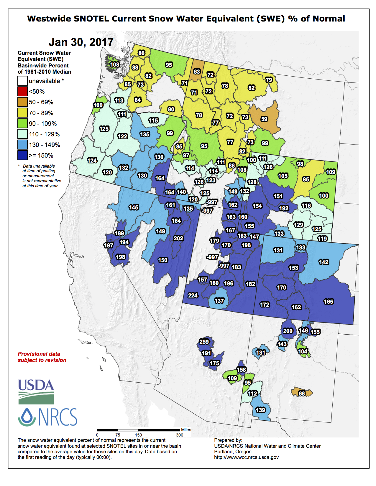


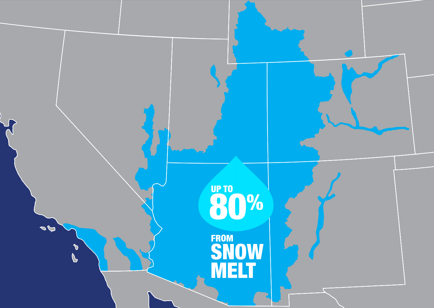

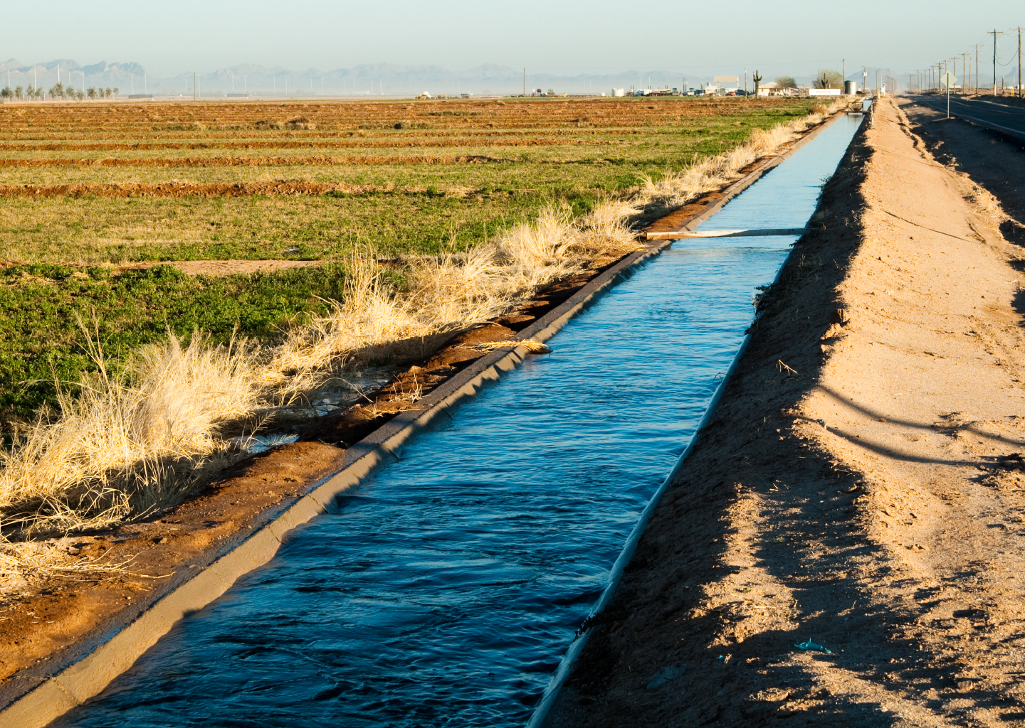
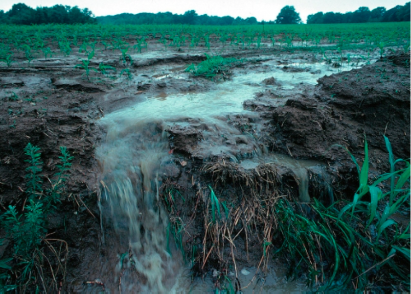
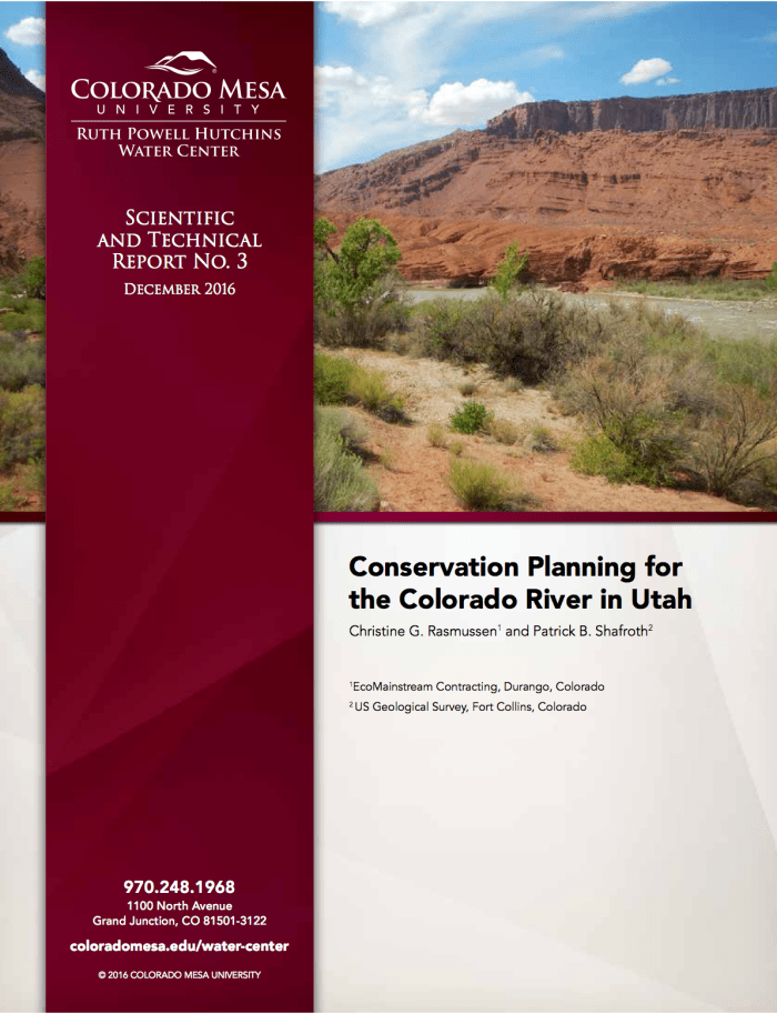
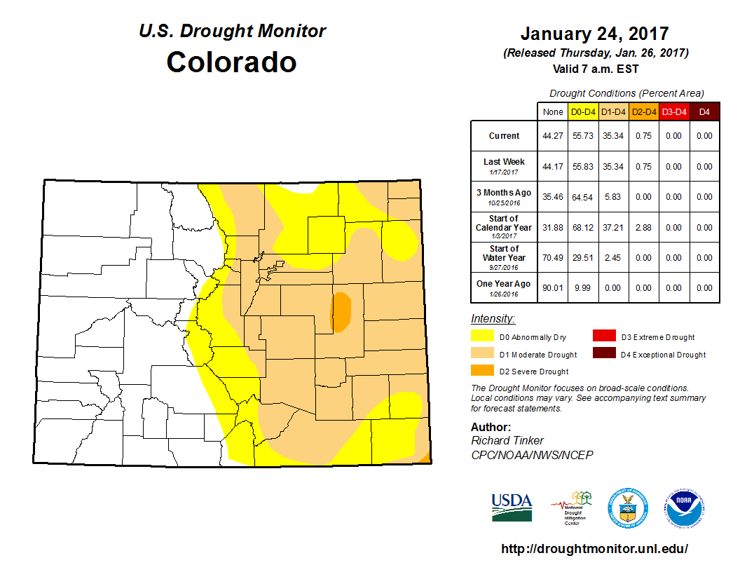


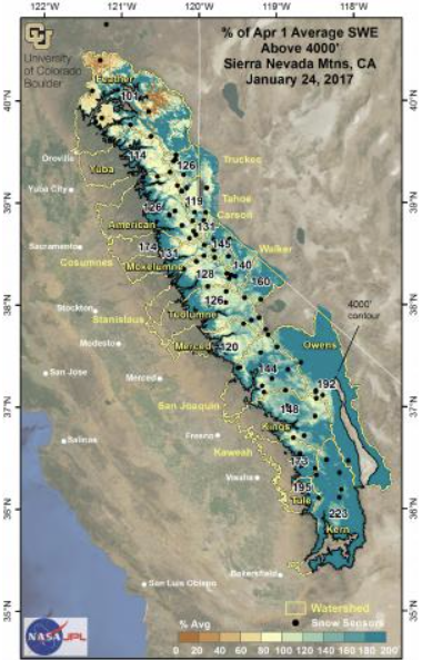


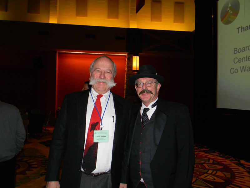
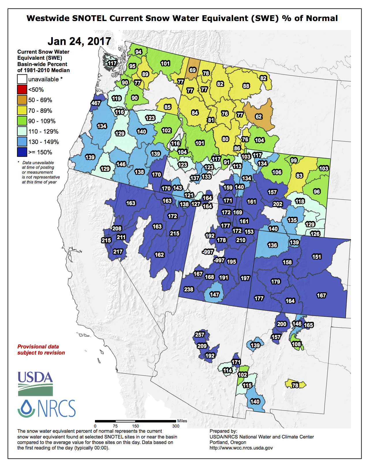


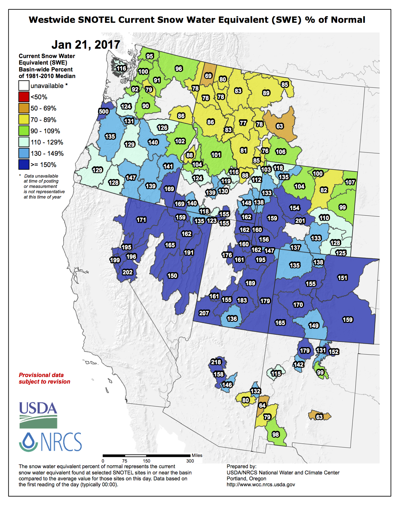


![The U.S. Whitewater Rafting Team trains on its custom-built raft in December on the Colorado River. The team was on pace for a record descent of the 277-mile canyon [January 14-15, 2017] when a wave broke the frame and punctured a tube. Photo Special to The Denver Post by Forest Woodward.](http://www.denverpost.com/wp-content/uploads/2017/01/bzxxgrandcanyon3.jpg?w=525)