The “Get the Lead Out” program creates a partnership between property owners and Pueblo Water to help eliminate lead service lines in the community. Pueblo Water soon will begin replacing older lead residential water service lines — the pipe connecting each residence to the water main in the street or alley — with Type K soft copper tubing, at no charge to the property owner.
Pueblo Water officials believe the lead lines in Pueblo’s service area comprise a very small percentage of the 40,000-plus customer connections…
Pueblo Water officials said the best protection for residents with lead service lines is to remove the potential sources of lead. Known lead service lines will be replaced as quickly as service schedules allow, minimizing any inconvenience to residents.
Should any service interruption be necessary during line replacement, residents will be given as much advance notice as possible.
In addition to the lead service line removal project, Pueblo Water has begun a physical inventory of service lines of unknown composition in neighborhoods where the known lead lines exist, in an effort to discover if there are any additional lead lines that have not yet been documented.
If and when additional lead lines are discovered, they will also be replaced at no charge to the customer.
From the Fort Collins Coloradoan (Jacy Marmaduke):
We’re not out of drought yet — the city and most of Larimer County remain in a moderate drought — but the new classification by the U.S. Drought Monitor is good news for Northern Colorado, which has been parched since June and officially entered drought territory in August.
A lot of factors go into the drought classification, including precipitation, soil moisture and stream flows, but it’s likely that recent snows in Northern Colorado and the Front Range were a big factor in the drought improvement. The monitor measures four stages of drought as well as abnormal dryness, the precursor to drought.
Thanks to big January snows, Fort Collins is right on the mark for average snowfall from November through mid-January and above the normal amount of precipitation, according to Colorado Climate Center data. The city has received 21.6 inches of snow since November and about 1.7 inches of precipitation, compared to 1981-2010 averages of 21.8 inches and 1.5 inches, respectively.
Meanwhile, several storms have hit the mountains that feed the South Platte River Basin, the main water supply for Northern Colorado, with 5 to 8 feet of snow since mid-November. That has the snowpack at 152 percent of normal for this time of year as of Friday.
Snow is piling up in the Rockies and Sierra Nevada, but this year’s first official water forecast for the Colorado River still predicts Lake Mead will shrink enough to trigger a federal shortage declaration in 2018.
Federal forecasters expect the lake’s surface to drop by about 9 feet by the end of 2017, which would put it inches below the all-important shortage line of 1,075 feet above sea level. That would force Nevada and Arizona to cut their use of Colorado River water under rules adopted a decade ago…
The picture is much rosier — and whiter — in California’s drought-ravaged Sierra Nevada range, where snow accumulations are well above average for this time of year. The southern end of the range especially has received almost double its normal amount of snow so far.
While that precipitation doesn’t directly benefit Lake Mead or Southern Nevada, it could help reduce California’s need for Colorado River water by refilling reservoirs within the Golden State…
Nevada, California and Arizona are closing in on a drought contingency plan, under which the states would voluntarily reduce their use of Colorado River water to prop up the reservoir. Arizona and Nevada would bear the brunt of the cuts early on, but California would also accept reductions to its share of the river for the first time under the deal…
At the same time, water officials in the U.S. and Mexico are in talks to extend and expand a treaty that governs how the Colorado is managed across the international boundary.
The new agreement, known as Minute 32X, lets Mexico continue storing some of its annual river allotment in Lake Mead and allows U.S. water agencies to invest in water-saving projects south of the border for a share of the water that is saved. It also spells out Mexico’s share of any shortages that might be declared on the river.
At this critical time of year for Colorado River snowpack, things are looking very good. For the first time this year, the April-July runoff forecast has climbed above 10 million acre feet.
The snowpack among the sites above Lake Powell where the federal government maintains real-time monitoring equipment is 57 percent above the long term median for this point in the year.
The amount of snow does not translate directly into river water because of a number of mediating factors – dry soils going into the season can soak up some of that, and warmer temperatures mean greater evaporation. That said, however, the latest model runs by the Colorado Basin River Forecast Center put April-July runoff at 40 percent above average. That’s the 10maf runoff forecast.
But since a key thing in water management is to enjoy the best but be ready for the worst, the most important thing in the CBRFC forecast is the forecasters’ bad news scenario. They calculate not only the most probable runoff, but also a sort of “worst case”, something you would expect in the driest 10 percent of years. That worst case right now is for above average runoff in the Colorado River Basin.
Here’s how this translates to policy, and why this is especially good news for those in the Lower Colorado River Basin trying to cope with the decline of Lake Mead. The nominal required release (shut up lawyers, I know that’s a contested characterization, let’s just go with it) from Lake Powell to Lake Mead each year is 8.23 million acre feet per year. When there’s more water in Powell, we move “bonus water” downstream, and lately there’s enough for 9 million acre foot releases. The current snowpack pretty greatly increases the probability of 9maf releases for the next couple of years, which makes it much easier to keep Mead from slipping into shortage.
The 1-in-10 best case scenario is nearly 13maf. Under Mead-Powell operating rules, a year like that would mean far more than 9 million acre feet for Lake Mead, which combined with current conservation efforts would buy the Lower Basin years of cushion before shortage.
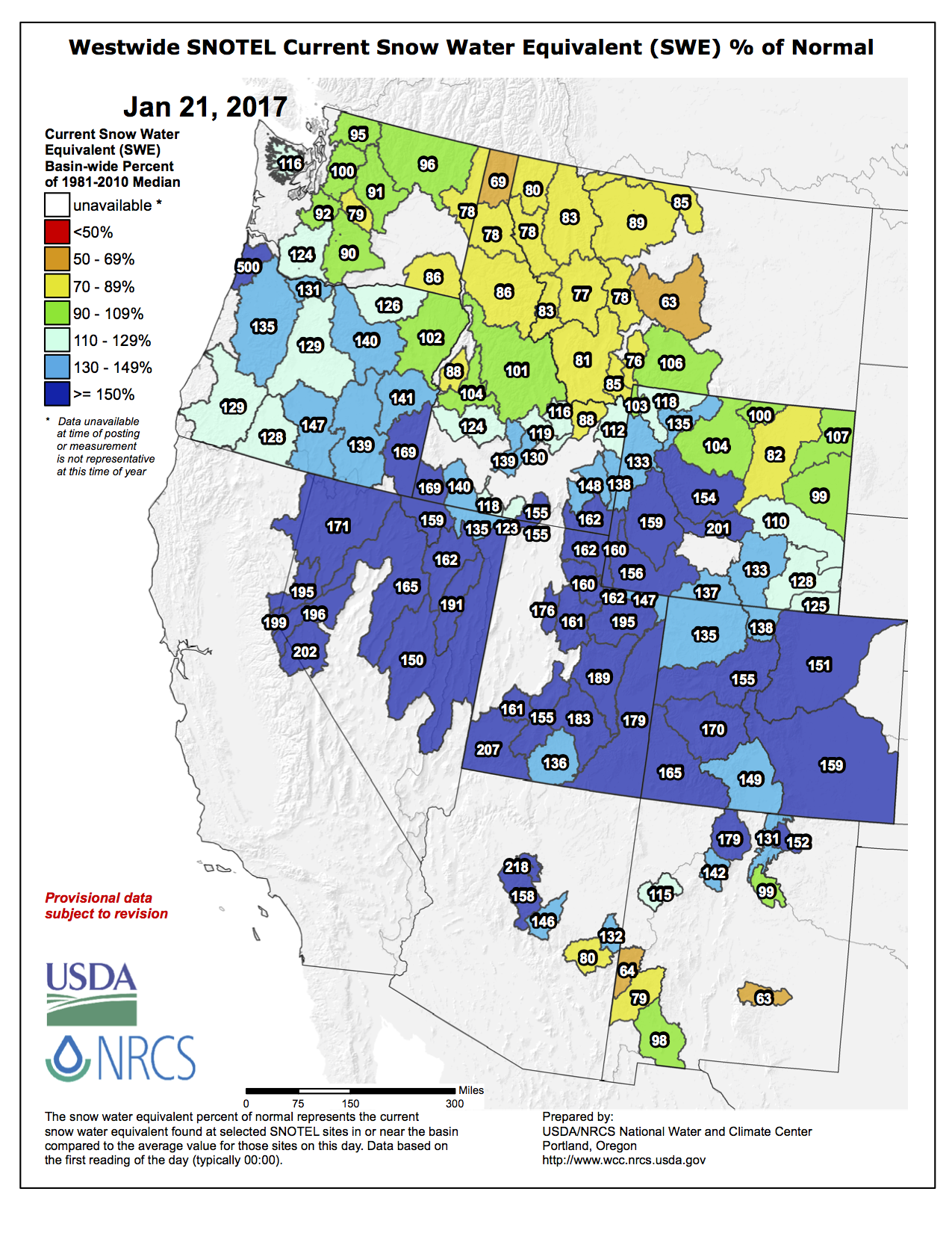
Westwide SNOTEL basin-filled map January 21, 2017 via the NRCS.
The U.S. Whitewater Rafting Team trains on its custom-built raft in December on the Colorado River. The team was on pace for a record descent of the 277-mile canyon [January 14-15, 2017] when a wave broke the frame and punctured a tube. Photo Special to The Denver Post by Forest Woodward.
In the pitch black of night on the Colorado River’s burly Lava Falls rapid, an aluminum bar had snapped and punctured a 4-inch hole in the inflatable beam of the custom-built craft. The air hissing from the punctured tube wasn’t just the sound of trouble. It signaled the dissipation of a dream to paddle the 277-mile length of the Colorado River’s Grand Canyon in record time…
In the roiling eddy below Lava, the sleep-deprived paddlers — they had been rowing non-stop for more than 20 hours — boiled water to heat a patch. It was dark and raining. The patches weren’t sticking. The tube wouldn’t inflate to the hard pressure needed for speed…
The six members of the U.S. Whitewater Rafting Team — the Eagle River Valley’s Jeremiah Williams, John Mark Seelig, Robbie Prechtl and Kurt Kincel, Seth Mason of Carbondale and Matt Norfleet of Breckenridge — spent more than a year building this mission. The team before them — the world champion Behind the 8-Ball rafting team — had set a 24-hour record in a similar vessel in 2006, paddling from the Upper Colorado below Gore Canyon to Moab.
Two days before President Donald Trump’s inauguration, outgoing Interior Secretary Sally Jewell laid out a game plan for averting serious water shortages along the Colorado River.
Jewell’s 10-page directive underscored the importance of concluding deals this year between California, Arizona and Nevada, as well as between the U.S. and Mexican governments, to share in reduced water deliveries to prevent reservoirs from falling to critical lows.
Her announcement accompanied a separate accord in which the Interior Department pledged to coordinate with California officials to manage the shrinking Salton Sea – where one agency’s demands for a detailed plan to keep the lake from turning into a dust bowl have become a sticking point in the talks toward a three-state Colorado River deal.
The new administration isn’t bound by Jewell’s order. Interior secretary nominee Ryan Zinke hasn’t yet made clear how he intends to deal with the complicated and interconnected issues of the Colorado River, which is severely overallocated, ravaged by a 17-year drought and threatened by global warming. But there has been widespread agreement during the past year among the states, water suppliers, scientists and environmental advocates that the status quo isn’t working in dry times, and everyone would benefit from preventing a crash in water supplies.
Jewell said before leaving office that all the parties, from states and tribes to her agency’s Mexican counterparts, have made tremendous progress in working toward agreements…
Jewell’s directive appears to stress the nonpolitical nature of a water-supply imbalance that must be addressed, said Jennifer Pitt, who leads the National Audubon Society’s Colorado River Project.
From the Associated Press (Ken Ritter) via Tucson.com:
The report release came the same week that outgoing Interior Secretary Sally Jewell warned that key drought contingency plans aimed at reducing the risk of water shortages in seven Western states remain unfinished as a new U.S. president takes office.
One issue involves a binational share-the-pain pact reached in November 2012 with Mexico that is set to expire. It lets Mexico store water in Lake Mead, which helps keep the lake above a trigger point where the U.S. Bureau of Reclamation would cut water deliveries to Arizona and Nevada.
The lake level on Friday was 8 feet above the line — down about 130 feet since 2000. The lake was last at full capacity in 1983…
In 2011, the river flow into the Lake Powell reservoir east of the Grand Canyon was 47 percent above normal, Davis said. Projections this year, so far, are for a 12 percent bump.
The bureau says there’s still about a 50-50 chance that a water shortage declaration will be made in August to trigger cuts in supplies to Arizona and Nevada in January 2018.
Arizona could lose 11 percent of its annual allotment, and Nevada could lose about 4 percent. The amount of water at stake could, combined, serve more than 625,000 homes. But deliveries to farms in Arizona would be affected first.
Nevada water managers say the effect would be felt less in and around Las Vegas, which draws 90 percent of its water from Lake Mead, because conservation and reuse programs have in recent years cut the amount of water the area uses.


![The U.S. Whitewater Rafting Team trains on its custom-built raft in December on the Colorado River. The team was on pace for a record descent of the 277-mile canyon [January 14-15, 2017] when a wave broke the frame and punctured a tube. Photo Special to The Denver Post by Forest Woodward.](http://www.denverpost.com/wp-content/uploads/2017/01/bzxxgrandcanyon3.jpg?w=525)