
From KUNC (Jackie Fortier):
“To have our snowpack where it is right now for the state is a really good position to be in going forward for water supplies into the spring and summer,” said Brian Domonkos, Colorado snow survey supervisor and hydrologist…
According to Domonkos, a strong snowpack is great news for farmers and water utilities, though it could change in the next few months.
“At this point we are about 50 percent done with our snow accumulation season. We could dry out to some degree, and we may not be quite as high for snowpack when the peak snowpack comes around in late April early May,” he said.
Colorado could see a record snowpack this spring — a situation Domonkos said was unimaginable in just November — but it could come with a price.
“As with any year that you have high snowpack, it all depends on how it melts,” he said.
“If it melts gradually that’s more what you want to see. Soils become saturated and then you can have a nice steady runoff and that provides a steady water supply through the summer.”
But under the right conditions, flooding could pose a problem later in the year for parts of the state.
“If we have a very high snowpack late into spring and then off a sudden temperatures warm up really quick and we have potential rain on snow events, then we can worry about very high [stream and river] flows,” Domonkos said.
At this point in the season, reservoirs across Colorado are at average levels. If they fill up too early, in the season more water will be sent downstream.
From The Fort Collins Coloradoan (Jacy Marmaduke):
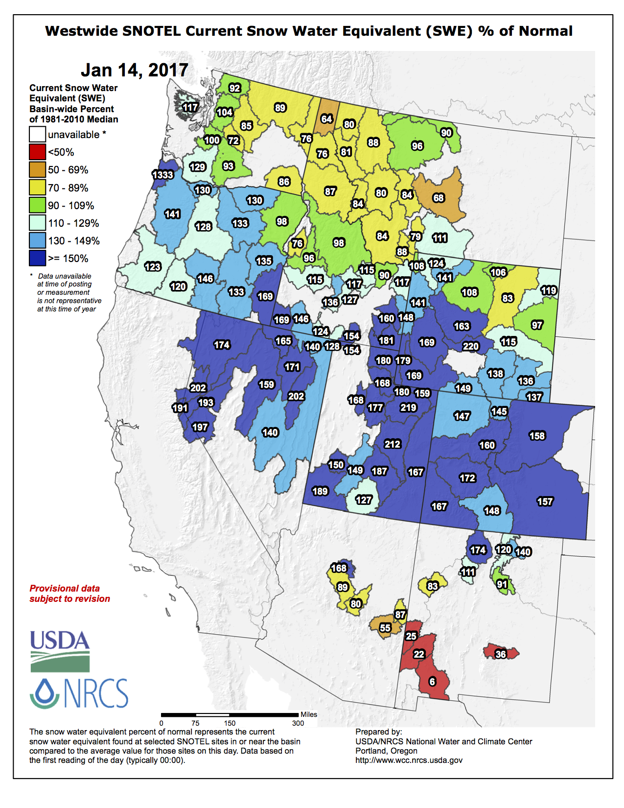
Colorado snowpack just saw its fastest turnaround in more than 30 years.
That’s a big deal for Fort Collins, which mainly relies on snowpack for its water supply and has been in a severe drought since August.
The story sounds like something out of a heartwarming underdog movie: By Nov. 17, 2016, Colorado’s water year was off to the worst start in more than three decades as a stubborn high-pressure ridge remained camped out over the Front Range. Snowpack in the South Platte River Basin, which supplies much of Fort Collins’ water, was about half of the average amount.
Just as hope waned, the high-pressure ridge began to break down, allowing the jet stream to meander into Colorado’s mountains and fill them to and in some place over the brim with snow. Several snowstorms have dropped 5 to 8 feet of snow since mid-November. And it’s been good, wet snow, too, which is even better for spring runoff.
South Platte Basin snowpack sat at 158 percent of normal Thursday morning. Statewide, we’re at 155 percent. The statewide rate of snowpack accumulation between Nov. 17 to Jan. 1 was the fastest Colorado has seen in 32 years, according to the Natural Resources Conservation Service…
Heavy snowpack is great for spring water supply, agriculture and winter recreation. But [Treste Huse] can’t help but worry just a little about enhanced flood risk. If inordinately high snowpack persists, rivers like the Poudre and the Big Thompson are in for major runoff come spring.
That’s not coming anytime soon, though, so conditions can — and likely will — change. Huse said NWS predicts a decent chance of normal or above-normal precipitation during the next few months.
“It’s been a roller coaster ride,” she said of Colorado’s snowpack. “You never know what’s gonna happen next.”

![This image was taken during the peak outflow from the Gold King Mine spill at 10:57 a.m. Aug. 5. The waste-rock dump can be seen eroding on the right. Federal investigators placed blame for the blowout squarely on engineering errors made by the Environmental Protection Agency’s-contracted company in a 132-page report released Thursday [October 22, 2015]](https://coyotegulch.blog/wp-content/uploads/2015/10/goldkingminespill1057am08052015viaepa.png)
