The NRCS released an updated snowpack map today.

The NRCS released an updated snowpack map today.
Click here to listen to the latest podcast from David McGimpsey. Here’s his intro:
Recently, I was fortunate enough to moderate a panel discussion at the opening plenary session of the American Water Resources Association’s 2016 Annual Conference, which took place in Orlando, Florida. The panelists were fantastic: Lester Sola and Hardeep Anand, the Director and Deputy Director, respectively, of the Miami-Dade Water and Sewer Department, Cindy Wallis-Lage, the President of Black & Veatch’s Water Business, and Shawn Grindstaff, Senior Resolution Counsel at the US EPA. This week’s podcast is the Q&A session from that conference – a big thanks to the AWRA and to each panelist for allowing the session to be recorded and released as a podcast. Give a listen for terrific insights on a wide range of water resources resiliency issues from these tremendous panelists.
Click here to read the newsletter. Here’s an excerpt:
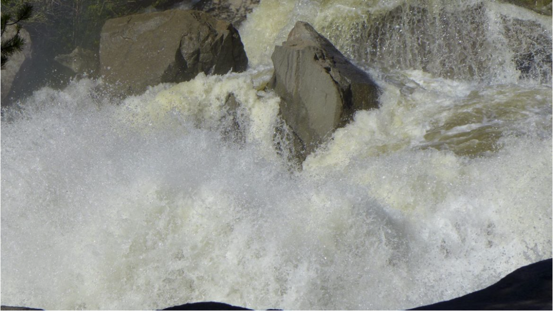
Aquatic Life Discovered on Mineral Creek Above Silverton
Recent studies by Mountain Studies Institute and the USGS on Upper Mineral Creek have found an improving macroinvertebrate population and a naturally reproducing brook trout population. For the past 20 years, this stretch was devoid of aquatic life. The Animas River Stakeholder Group has conducted a dozen mining remediation projects above that reach on Mineral Creek, which has dramatically improved water quality. ARSG will request that the Colorado Water Quality Control Commission make an aquatic life designation under the Clean Water Act for that segment of Mineral Creek. Congratulations to ARSG and its many partners for this water quality remediation success!

Click here to read the newsletter. Here’s an excerpt:
It’s been a busy year for the Watershed Council. The board and staff would like to take this time to thank everyone that participated in the wide variety of activities presented by our organization in 2016—from our educational Watershed Wednesdays series held throughout the valley, the sold out Wild and Scenic Film Festival, our annual Highway Cleanup, to our signature River Cleanup event. We would like to thank all of our funding partners that supported our mission of advocating for our rivers through educational programs, special events, restoration projects, monitoring, research, and community engagement.
Eagle River Watershed Council believes that our rivers and streams are the life-blood of our valley. Their preservation and restoration supports our economy, culture and quality of life.
The Watershed Council’s annual programs and events represent the public side of the work we do, but we are also involved in a variety of partnership efforts such as providing water quality sampling along Gore Creek, the Eagle River, and various tributary streams within the watershed. The sampling data collected and compiled by the Watershed Council is available in an interactive and easy to understand format online at http://wqcourier.erwc.org. The data also provides a baseline which can be used to identify emerging threats or effectiveness of stream health improvement projects.
Eagle River Watershed Council has coordinated the effort to improve water quality in our local streams through its participation in the Urban Runoff Group, a stakeholder committee that includes entities such as Eagle County, CDOT, Eagle River Water and Sanitation District, the towns of Avon and Vail, Vail Resorts and the Vail Recreation District. This group initiated the Gore Creek Water Quality Improvement Plan in 2013 and the Gore Creek Strategic Action Plan in 2015 culminating in the “Restore the Gore” program, for which projects are currently underway. The Watershed Council applauds the Vail Town Council for their vision in understanding that the health of Gore Creek benefits all user groups and for beginning the process of improving water quality on the Gore.
The three major factors that are likely affecting aquatic life in Gore Creek are not exclusive to that stream and can affect all urbanized waterways within the watershed. They are:
Pollution from chemicals used in urbanized areas adjacent to streams, such as fertilizers, weed killers and pesticides used in landscaping. An increase in stormwater runoff from impervious areas such as roads, parking lots, buildings, and other hardscape areas that prevent infiltration of rain and snowmelt that would recharge the aquifer and support base flows. Loss of vegetation along the stream. These riparian plants normally play a critical role in filtering pollutants from storm water runoff before it enters the stream. The Watershed Council, through the Urban Runoff Group, has just completed an action plan for a segment of the Eagle River from its confluence with Gore Creek downstream to the EagleVail half diamond interchange. In assessing this section of river, the Watershed Council provided recommendations to mitigate the effects of urbanization affecting water quality. This includes recommendations for changes to land use regulations, improved storm water infrastructure, and projects to restore vegetation along the stream.
In 2017, we look forward to assisting with the implementation of the completed Action Plans and completing the same process through the other communities in the valley.
We have a full schedule of Watershed Wednesdays, filled with great tours and engaging presentations, coming together for the year as well. Our 2017 restoration projects are in design and planning now, we look forward to utilizing our wonderful cadre of volunteers this next summer in implementing those. Stay tuned if you are interested in getting involved.
With the addition of new boat ramps, increased river access through open space parcels and an increase in population over the last several years, river usage is at an all time high. We as a community need to be vigilant to balance the economic and recreational usage of our rivers that we all enjoy with the need to improve or maintain a high level of water quality throughout the watershed.
Gary Brooks is the Board Chairman for Eagle River Watershed Council. The Watershed Council has a mission to advocate for the health and conservation of the Upper Colorado and Eagle River basins through research, education, and projects. Contact the Watershed Council at (970) 827-5406 or visit http://www.erwc.org.
From email from the Colorado Water Conservation Board (Rob Viehl):
The CWCB’s annual Instream Flow Workshop will be held on the afternoon of January 25, 2017 at the Hyatt Regency Denver Tech Center in conjunction with the Colorado Water Congress Annual Convention. There is no fee for this particular workshop, and registration with the Colorado Water Congress is not required.
Each year, the CWCB’s Stream and Lake Protection Section hosts an annual workshop that provides state and federal agencies and other interested entities and persons an opportunity to recommend certain stream reaches or natural lakes for inclusion in the State’s Instream Flow (ISF) Program. The entities that make ISF recommendations will present information regarding the location of new recommendations as well as preliminary data in support of the recommendation. There will be an opportunity for interested stakeholders to provide input and ask questions. In addition to presentations of new ISF recommendations, this year’s workshop will include: (1) an overview of the ISF Program and the new appropriation process; and (2) discussion of pending ISF recommendations from previous years.
For a general overview of the new appropriation process, please visit: http://cwcb.state.co.us/environment/instream-flow-program/Pages/InstreamFlowAppropriations.aspx
Date: Wednesday, January 25, 2017
Time: 1:30 p.m. – 3:30 p.m.
Location: Hyatt Regency Denver Tech Center
Grand Mesa D/E Meeting Rooms
7800 East Tufts Ave
Denver, Colorado 80237If you have any questions regarding this workshop, please contact Rob Viehl: rob.viehl@state.co.us


By Brent Gardner-Smith, Aspen Journalism
ASPEN – The United States of America and Pitkin County are among the 10 parties that have filed statements of opposition in two conditional water rights cases being pursued by the city of Aspen in water court for Maroon Creek Reservoir and Castle Creek Reservoir.
In addition to the two governments, four environmental organizations and four private-property owners filed statements in the cases by the Dec. 31 deadline.
Such statements of opposition are typically short and generic, and simply give notice of formal entry into a case. But the statements filed by the U.S. and Pitkin County offer some insight into their concerns about the city’s water rights applications.
Attorneys at the U.S. Justice Department acting on behalf of the U.S. Forest Service told the court the city “cannot show that it can and will” complete the two reservoirs “within a reasonable time” because both potential reservoirs would flood portions of the Maroon Bells-Snowmass Wilderness.
And Pitkin County told the court the city “appears to be speculating with no reasonable demonstration of need” for the reservoirs.
The city filed two applications in Division 5 water court in Glenwood Springs on Oct. 31, one for Maroon Creek Reservoir (16CW3128) and one for Castle Creek Reservoir (16CW3129). Aspen is seeking to extend the conditional water storage rights for another six years. The rights were appropriated in 1965 and adjudicated in 1971.
The city has filed diligence applications for the reservoirs eight prior times, in 1972, 1977, 1981, 1985, 1989, 1995, 2002 and 2009, and each time has been awarded a new diligence decree for the conditional rights.
The conditional rights, as currently decreed, cannot be made absolute unless the city builds a dam 155 feet tall and an estimated 1,280 feet wide across Maroon Creek, within view of the Maroon Bells, and a dam 170 feet tall and an estimated 1,220 feet wide across upper Castle Creek.
The Maroon Creek Reservoir would hold 4,567 acre-feet of water and flood 85 acres of land, and the Castle Creek Reservoir would hold 9,062 acre-feet of water and flood 120 acres of land. Water in both reservoirs would flood some land within the wilderness boundary.
The federal case
The two statements of opposition from the federal government are nearly identical, save for the name of the potential reservoirs in each case. Both begin by saying the reservoir would require a Forest Service permit, and then they raise the wilderness issue.
“Maroon Creek Reservoir would impound water that would inundate lands within the Maroon Bells – Snowmass Wilderness Area,” the statement in the Maroon Creek case said. “Development of Maroon Creek Reservoir is not authorized by [federal law] or any existing special use permit or land use authorization.
“Under the Wilderness Act of 1964, the U.S. Forest Service cannot authorize any new development of conditional water rights, including the conditional water right requested in Case No. 16CW3128 in the Maroon Bells–Snowmass Wilderness Area,” it continued.
“Because the applicant [the city] does not hold a valid right to use or occupy national forest system lands, and the U.S. Forest Service lacks authority to authorize development of Maroon Creek Reservoir within the Maroon Bells–Snowmass Wilderness Area, the applicant cannot show that it can and will complete the claimed appropriation within a reasonable time,” the statement of opposition said.
The statements of opposition from the U.S. were signed by John Cruden, the assistant attorney general at the Environment and Natural Resources Division in the Department of Justice in Washington, D.C., and James DuBois, a trial attorney with the department, who is based in Denver.
In September, the acting district ranger in the Aspen-Sopris Ranger District, Kevin Warner, told the Aspen City Council it would take a presidential exemption to the Wilderness Act to allow the Forest Service to issue a permit for the reservoirs.
“Based on our understanding of the Wilderness Act, and the fact that there was no exception built into the designation for the Maroon Bells wilderness area … it would need to go to the president,” Warner said.
The city has not filed for a Forest Service permit for either reservoir.
Pitkin County’s view
Staff attorneys for Pitkin County told the court that the city should be held to “strict proof” to its claims, including its “ownership of or enforceable property interest” in the dam and reservoir sites.
“This water right is located within a designated wilderness area and the applicant’s ability to obtain the property interest necessary to construct the structure, as decreed, within this wilderness area is unproven,” the county told the court.
The county also told that court the city’s 2016 water supply study “demonstrates that this water right is unnecessary to meet current and future demand within a reasonable planning period using normal population growth assumptions.”
It also said recent statements by Aspen’s mayor and city council members “indicate that (the city) does not intend to effectuate these water rights in a reasonable time period,” and that the city “appears to be speculating with no reasonable demonstration of need.”
16 statements
In all, 16 statements of opposition were filed in the two water court cases by 10 different parties.
In addition to the two governments, U.S. and Pitkin County, four environmental organizations filed statements in both cases: Colorado Trout Unlimited, American Rivers, Wilderness Workshop and Western Resource Advocates.
As such, there is a common set of six parties in each case – the two governments and the four environmental groups – and they’ve filed 12 statements between them, six in each case.
There are also four different property owners, two in each case, and they each filed one statement. That adds four statements to the list of 12, for a mind-numbing total of 16.
Making it somewhat easier to track, the list does break out into eight parties in each case: two governments, four environmental organizations, and a unique pair of property owners.
The differing pairs of property owners in each case brings to 10 the total number of parties across the two cases.

Property owners
The two property owners who filed in the Maroon Creek case are Roaring Fork Land and Cattle Co. and Larsen Family LP.
Roaring Fork Land and Cattle is an entity controlled by Thomas and Margot Pritzker. The Pritzkers, who are on the Forbes billionaires list, own property near T-Lazy-7 Ranch in the Maroon Creek valley.
Marcella Larsen of Aspen is the co-manager of the Larsen Family LP, based in Boca Raton, Fla., and she signed the statement of opposition. The Larsen family owns residential property in the lower Maroon Creek valley.
The two property owners who filed in the Castle Creek case are Double R Creek Ltd. and Asp Properties LLC. Double R Creek is controlled by Robert Y.C. Ho, a member of a prominent Hong Kong family, while Asp Properties is controlled by Charles Somers, the CEO of a company based in California.
The properties owned by Ho and Somers are located under the potential dam site of Castle Creek Reservoir, two miles below Ashcroft.

Environmental arguments
The statements of opposition filed by the four environmental groups do not offer much insight as to why they are in the cases, but they issued press releases about their filings.
“Aspen does not need these dams for municipal water supply, climate resiliency, or for stream protection – now or at any time in the foreseeable future,” a Dec. 28 from om American Rivers quoted Matt Rice, its director of programs in the Colorado River basin, as saying.
The same release also quoted David Nickum, the executive director of Colorado Trout Unlimited, as saying, “Building dams on free-flowing streams in one of Colorado’s most iconic wilderness areas is the last approach we should be taking to meet water needs in the 21st Century.”
Wilderness Workshop of Carbondale, which is collaborating with Western Resource Advocates of Boulder, released both a press release on Dec. 21 and an article about the water court cases from its newsletter.
“Both dams would inundate portions of the Maroon Bells-Snowmass Wilderness and cause significant environmental damage: severing the streams in two, flooding important riparian habitat, and reducing the ecologically critical spring peak flows,” Wilderness Workshop’s newsletter said.
“The city council met three times this fall to discuss water rights, but those meetings focused almost exclusively on the impact of population growth and climate change to Aspen’s future water supply,” Wilderness Workshop members were told. “They were silent on the ecological impacts of the dams, the regulatory obstacles, financial costs and dubious assertion that these rights actually protect the streams. Over a dozen concerned citizens spoke, unanimously asking the city to abandon their water rights.
“Despite this outcry, the city is moving ahead. All five council members justified their vote on the basis that we might need to store water in the future despite their recent study concluding just the opposite,” the organization said.
In its press release, the Wilderness Workshop quoted Will Roush, its conservation director, as saying: “We’re filing for two reasons: first, to have a seat at the table with the city and other parties to find common ground and second, to make sure that dams are never built on Castle or Maroon Creeks.”

City’s position
David Hornbacher, the city’s director of utilities and environmental initiatives, declined to comment on the statements of opposition.
A resolution unanimously approved by the city council on Oct. 10 said, “the city is obligated and intends to provide a legal and reliable water supply and to that end can and will develop all necessary water rights, including but not limited to, Maroon Creek Reservoir and Castle Creek Reservoir.”
In its diligence applications, the city told the court the two reservoirs are “part of Aspen’s integrated water supply system” and “part of Aspen’s long-range plan to maintain a water supply to meet current and future demand.”
Further, the city said it has “steadily applied effort to complete the appropriation” of the water rights for the reservoirs and it has done so “in a reasonably expedient and efficient manner under all the facts and circumstances.”
However, in its Oct. 10 resolution, the city council also directed its staff to “enhance and increase the city’s efforts to investigate alternative locations and sizing requirements of the Maroon Creek Reservoir and/or Castle Creek Reservoir, and to report its findings back to City Council for further consideration and action as appropriate.”
Typically in water court cases, opposing parties are given a year to try and work out their differences under the guise of a water court referee. The discussions among parties in this phase of the process are private.
If parties cannot reach agreement within a year, they can ask for another six months. And then dates are eventually set for a trial in front of a judge.
Editor’s note: Aspen Journalism, the Aspen Daily News, and Coyote Gulch are collaborating on coverage of rivers and water. The Daily News published this story on Monday, Jan. 2, 2017.

Here’s the release from the Rio Grande Headwaters Land Trust:
In 1999 the Rio Grande Headwaters Land Trust (RiGHT) was founded as the community‘s land trust, dedicated to serving the entire San Luis Valley. In 2007, RiGHT launched the Rio Grande Initiative, the landscape scale effort with many partners to protect land and water along the Rio Grande and its tributaries. One of the first ranches they protected under the Initiative is owned by Bob and Carol Lee Dugan on the river on Swede Lane, just west of Monte Vista. Now, nearly ten years later, RiGHT is proud to announce that the Dugans have protected yet another nearby ranch with a conservation easement.
This 316-acre ranch, which combines parcels previously known as the James Ranch and the Stephens Ranch, is just south of the river between Monte Vista and Del Norte. Between the two ranches, the Dugans have now protected a total of 670 acres with conservation easements. In doing so, they have also protected the water that goes with those ranches, the wildlife habitat, the beautiful views, and the important agricultural productivity. Clearly, this represents a strong commitment to conservation by Bob and Carol Lee Dugan and they continue to recommend conservation to others, saying, “We suggest that other land owners consider preserving their ranches for the future generations of this state.”
“We are immensely grateful to the Dugan family for their dedication to their properties along the Rio Grande,” said Nancy Butler, RiGHT’s Executive Director. “Their land ethic has helped RiGHT and our partners protect more than 26,000 acres along the Rio Grande and its tributaries. That legacy will continue far into the future and that land, water and wildlife habitat will remain intact for all to enjoy.”
The conservation of the 2016 Dugan Ranch project was made possible through the generous support of the Natural Resources Conservation Service (NRCS), the Gates Family Foundation, the Colorado Water Conservation Board (via funding supported by the Rio Grande Basin Roundtable) and the Colorado Parks and Wildlife’s San Luis Valley Habitat Partnership Program Committee. Invaluable support has also been provided by individual donors who ensure that RiGHT’s conservation work can continue.
As an agency of the U.S. Department of Agriculture, the NRCS’s mission is to help people help the land. Colorado’s NRCS State Conservationist Clint Evans stated that, “Protecting vital agricultural landscapes is a top priority for NRCS. Through the Agricultural Conservation Easement Program – Agricultural Land Easement (ACEP-ALE), the natural resource benefits we all enjoy derived from prime agricultural lands can be preserved.”
“This project is an important contribution to the corridor of conservation in this area of the river, with nearly 1,500 acres already conserved nearby,” said Butler. “RiGHT has conserved four other spectacular ranches in this area, providing excellent wildlife habitat and maintaining the beautiful scenery that we all love in the San Luis Valley. Carol Lee and Bob Dugan have demonstrated immense dedication to preserving these lands in perpetuity and we are grateful that RiGHT was able to help them achieve their dreams for these special places.”

From The Washington Post (Chris Mooney):
The Arctic continues to amaze. Hit by a second bout of extremely warm winter temperatures in recent days, the seasonal growth of floating sea ice has flattened out, just as it did when hit by similarly dramatic heat in November.
The area of the Arctic Ocean covered by sea ice is currently far smaller than it was in 2012 at this time of year. And while 2012 holds the all-time record for lowest ice extent in September, 2016 has been beating it since mid-October…
The current extent of Arctic ice sea is also far smaller than it was at the same time in 2010, which previously held the record for lowest Arctic sea ice extent in late December, according to records from the National Snow and Ice Data Center that date to 1979.
Clearly this is abnormal. But how abnormal?
The answer is that what has happened this year in the Arctic, and particularly the high Arctic, appears to be not only out of the norm for a stable climate — like the one on Earth before the era of fossil fuels — but also for what you might expect from our supercharged, artificially warmed climate.
Such is the upshot of a recently published “detection and attribution” analysis of November’s and December’s Arctic warmth by a group of scientists who are not waiting around for the peer review process — they are increasingly releasing these documents in near real time. And they find that “it is extremely unlikely that this event would occur in the absence of human-induced climate change.”
The analysis was conducted by a World Weather Attribution, a consortium of researchers who are perfecting the study of how a changing climate affects local weather conditions, or conditions in a specific place. It came out last week, but the researchers say that in light of another burst of Arctic warmth since, the analysis holds up. If anything, the ensuing temperatures were slightly hotter than they’d expected.
“We probably slightly underestimated the temperature as a whole for November-December, but not by much,” says Andrew King, a researcher at the University of Melbourne who worked on the study.
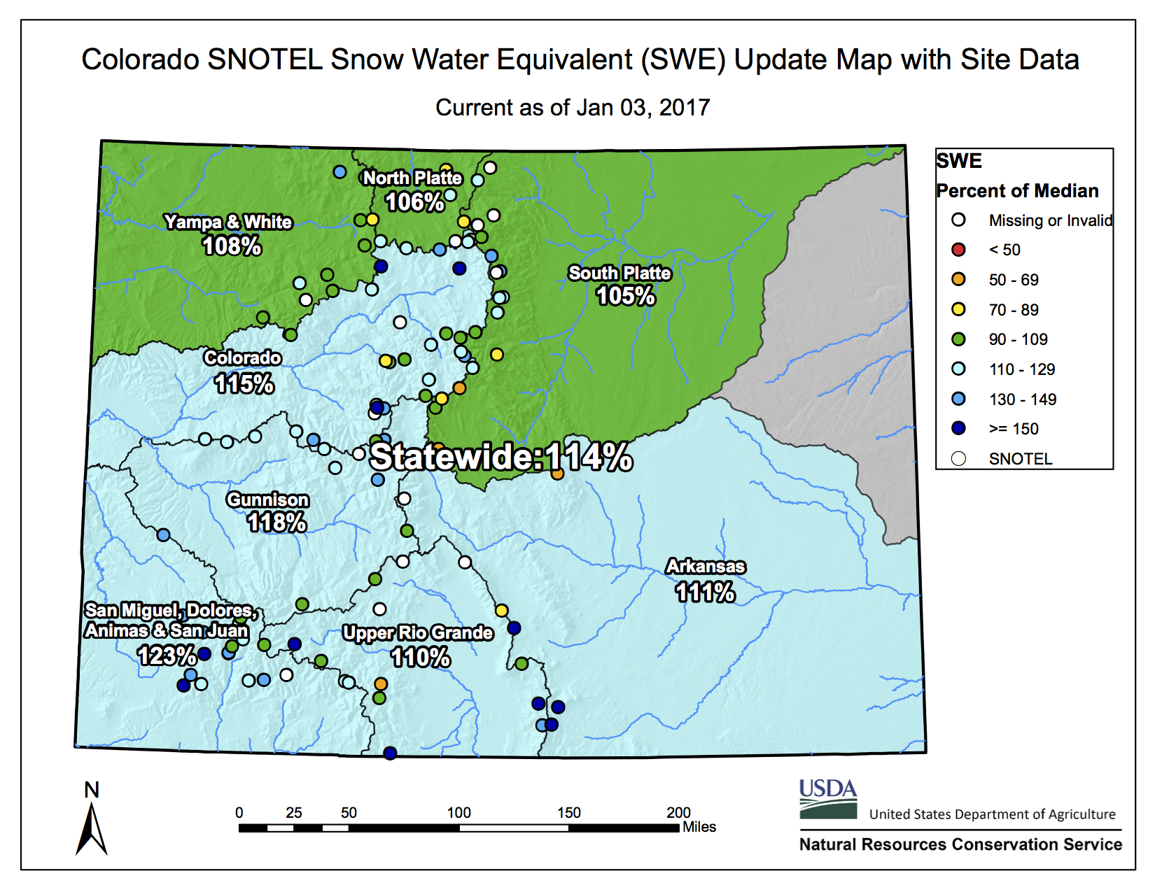
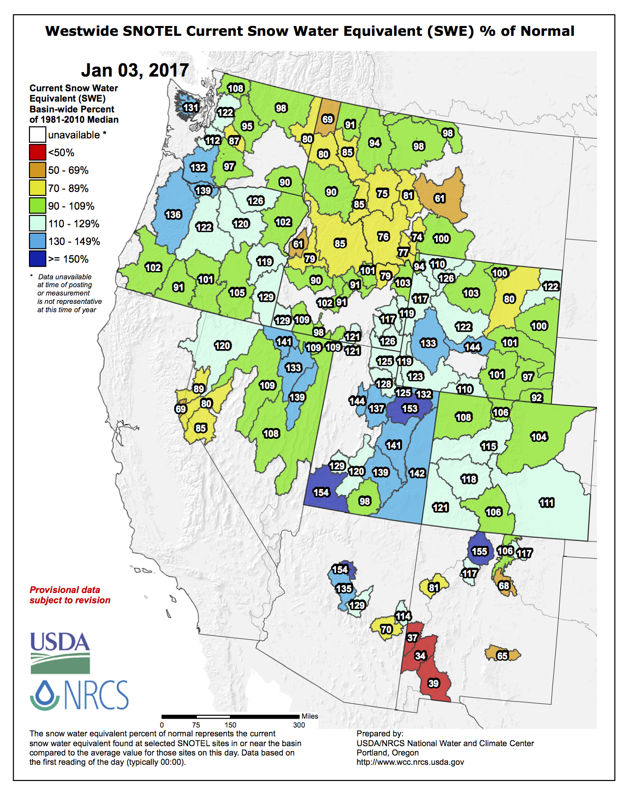
Below is the westwide basin-filled map from December 28, 2016. NRCS maps have not been updating over the holiday weekend.

From The Pueblo Chieftain (Jon Pompia):
As 2016 draws to a close, the yearlong precipitation level is lower than in 2015 but not far off from the average annual precipitation.
Through Friday, 2016’s precipitation level was 11.91 inches, down when compared to 2015’s mark of 16.66 inches. When compared to the average annual precipitation of 12.55 inches, however, this year’s moisture level is only slightly lower.
According to the U.S. Geological Survey water supply website, Fountain Creek and the Arkansas River are currently above average; flows were mostly above average throughout the year.
From a standpoint of moisture content in the state’s snowpack, recent holiday weather fronts proved to be a welcome gift. The fronts deposited enough snow in the mountains to put the state over the average for the year in terms of moisture content.
As of Friday, the Arkansas basin’s moisture content was at 115 percent of average, and the Rio Grande basin was at 106 percent of average.
The National Weather Service’s three-month temperature outlook indicates that Pueblo will be above average, with an equal chance of conditions being wet or dry through that timespan.
Chris Woodka of the Southeastern Colorado Water Conservancy District points out that, “We imported 59,214 acre-feet of water this year (2016) from the Fryingpan River watershed, which was just slightly above the average of 55,907 acre-feet for the Fry-Ark Project.
“It was a good year, because we were able to provide 45,000 acre-feet of supplemental water for municipal, domestic and agricultural use in the Arkansas River basin,” he said.
Statistics provided by the Board of Water Works indicate that city water consumption was higher in 2016 than the previous year: 7,900,914 gallons to 7,511,255, but under the five-year average of 8,104,317.
As far as pumpage, the water that is treated and then sent out from the plant, 8,481,644 gallons were pumped, an increase over 2015’s 7,924,727 but below the five-year average of 8,614,500.
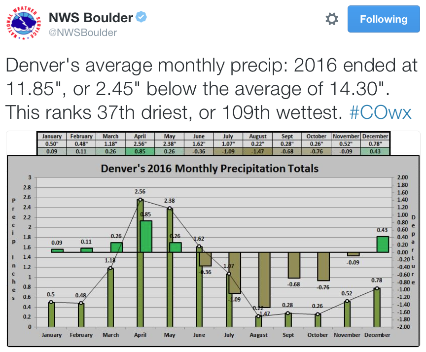
Meanwhile Denver was drier over the past year: