Here’s the release from Western Resource Advocates:
Western Resources Advocates (WRA) released a new analysis today that shows Central Arizona’s cities, suburban growth in significant areas, and agriculture face substantial cuts in Colorado River water supplies if Lake Mead levels continue to fall. Analysis of data from the Arizona Department of Water Resources (ADWR) and Central Arizona Project (CAP) identifies who could face a reduction of Colorado River supplies, and at what level, within Arizona as Lake Mead levels continue to drop.
Phoenix and Tucson suburban growth that uses the Central Arizona Groundwater Replenishment District to prove there is renewable water to cover development will be cut first in a shortage declaration under existing agreements;
Four important Central Arizona Irrigation Districts could also lose a substantial portion of their CAP water, including Maricopa Stanfield, Central Arizona, Hohokam, and Harquahala; and
Major cities, including Phoenix and Tucson, could face a reduction of Colorado River supplies within this decade if Lake Mead drops below the 1,025’ level.
These cuts are looming because Arizona’s ”bank” for 40% of its water supply, Lake Mead, is being drained faster than it can be filled. The U.S. Bureau of Reclamation estimates there is a nearly 50% chance of a federal shortage declaration, that would cut 320,000 acre-feet of Colorado River water deliveries to Arizona, happening as soon as 2018 under business as usual. This level of cuts could harm agriculture, lead to over-drafting of nonrenewable groundwater, reduce hydroelectric power, and provide a lot less water for Arizona cities and the environment.
“Arizona is facing perhaps its greatest challenge since the settlement of the region and development of modern cities, agriculture, and industry,” said Drew Beckwith, Water Policy Manager, Western Resource Advocates. “The time is now for ADWR and CAP to put in place longer-term solutions that prevent significant water shortages and stand the test of time. One cannot put Band-Aids on an ill patient, while failing to address the underlying illness.”
Arizona has already taken important action by implementing interim measures to keep more water in Lake Mead to help stave off federally mandated cutbacks of Colorado River water. The Arizona Department of Water Resources has also been working with California, Nevada, and key water users within Arizona on plans to keep Lake Mead from falling to critically low levels.
Western Resource Advocates and conservation partners at American Rivers and Environmental Defense Fund have developed seven policies and actions to protect groundwater and help Arizona’s agriculture, cities, Indian tribes, economy, and environment thrive in a future with less Colorado River water supplies.
Three of the seven proposed policies and actions are:
Water providers and farmers, with support from ADWR, should adopt next-generation water conservation and efficiencyfor our homes, business and agriculture.
The Central Arizona Project should expand its support of system conservation programs allowing municipalities and other water users to dedicate conserved water to stay in Lake Mead to prevent water levels from dropping farther.
Water providers, cities and agriculture, with support from CAP and ADWR, should increase the number of innovative water sharing arrangements between themselves,like the Phoenix-Tucson water sharing agreement.
“System Conservation Programs have proven to be a great success along the Colorado River, putting more water into Lake Mead and keeping the lake from falling to drastically low levels,” said Jeff Odefey, Director, Clean Water Supply, American Rivers. “Innovative water sharing agreements, like that between Phoenix and Tucson, are an ideal example other water interests should adopt, demonstrating the collaboration and flexibility we will need to stabilize Lake Mead levels for the long term.”
“We are all in this together in the Colorado River basin. ADWR is on the right track with increasing the level of collaboration and proactive actions with all Arizona water stakeholders. Now ADWR and stakeholders need to also adopt longer-term solutions,” said Kevin Moran, Senior Director, Colorado River Program, Environmental Defense Fund. “In the end, the strategy which has served Arizona and the Lower Basin states the most is to focus on collaboration and ongoing water management innovation that benefit both current and future generations.”
The Colorado Agricultural Leadership Program is proud to host the 26th annual Governor’s Forum on Colorado Agriculture, titled “Label it: Agriculture,” and focusing on a future built by collaboration. This innovative and informative program will bring together producers, consumers, experts and other ag stakeholders to peel back the polarizing rhetoric often found in today’s society.
Stories can create divisive boundaries in agriculture between organic and conventional; urban and rural; large-scale and small-scale. The Forum will instead focus on the powerful history of collaboration and cooperation that has made agriculture in the state of Colorado the second largest driver of our economy. It will challenge and equip attendees to seek out novel alliances and ideas to benefit their own operations, the industry statewide, and beyond.
Registered attendees of the Forum are also invited to a pre-Forum reception, taking place from 5-7 p.m. on Tuesday, Feb. 21, at the Governor’s Residence at Boettcher Mansion (400 E 8th Avenue, Denver, CO 80203).
Joining a myriad of other speakers at the 2017 Governor’s Forum on Colorado Agriculture, Gov. John Hickenlooper and Colorado Agriculture Commissioner Don Brown will each be stepping up to the podium at the event.
Gov. Hickenlooper and Commissioner Brown will help lead a Forum that this year is titled “Label It: Agriculture,” focusing on how collaboration and cooperation have made agriculture in Colorado the state’s second-largest driver of our economy, and how similar efforts will be critical moving forward.
Other presenters and panelists at this year’s Forum – taking place on Wednesday, Feb. 22, at the Renaissance Denver Stapleton Hotel – will include:
* Krysta Harden, former U.S. deputy secretary of agriculture, and current vice president of public policy and chief sustainability officer for DuPont
* Gregory Graff, ag-economics professor at Colorado State University
* Keith Belk, animal sciences and public health professor at Colorado State University
* Holly Butka, global consumer engagement lead at Monsanto
* Norm Dalsted, professor and extension farm/ranch management economist at Colorado State University
* Tom Lipetzky, director of marketing programs and strategic initiatives at the Colorado Department of Agriculture
* Tom Kourlis, Colorado rancher
* Stephanie Regagnon, CEO of FieldWatch Inc.
* Dawn Thilmany McFadden, professor and agribusiness extension specialist at Colorado State University
* Virginia Till, recycling specialist and regional lead for EPA Region 8’s Sustainable Food Management
Looking back on Earth’s global temperature over the past three years…2014: record warm—wow! 2015: record warm—wow!! 2016: record warm—holy cow!!!
In 2016, the annual global temperature reached a record high for the third year in a row, a remarkable occurrence rarely seen in the 137-year NOAA record and one not seen since the streak of record warmth (at the time) of 1939, 1940, and 1941.
Each year’s global surface temperature compared to the twentieth-century average from 1880-2016. The three hottest years on record (2014–16) are colored red. The last record-warm “three-peat” was the period from 1939–41. Due to global warming, those years don’t even rank in the top 30 warmest on record. Graph by NOAA Climate.gov, based on data from NCEI’s Climate at a Glance.
Those years, which ranked as third warmest, second warmest, and warmest, respectively, in 1941, now rank as 64th, 50th, and 38th warmest today. But back to the current streak…how did this happen?
If you guess long-term climate change—Yes! If you guess El Niño—Yes! Also correct. If you guess supermoons—umm, sorry, not so much.
The Background
First, Earth’s temperature has been rising at an average rate of 0.13°F each decade since the start of the record in 1880 and more than twice that rate (0.31°F) if you consider the past half century alone. That increase is due to long-term warming.
Second, natural climate cycles, the biggest player being the El Niño-Southern Oscillation (ENSO), cause global temperatures to temporarily rise (El Niño) or fall (La Niña). Generally, the stronger the El Niño or La Niña, the greater the impact will be on the average global temperature. Over time, the effects of El Niños and La Niñas balance each other out, so the net effect on long-term warming is negligible.
Monthly temperature departures from average color coded by the warm (red, El Niño) and cool (blue, La Niña) phases of the El Niño-Southern Oscillation climate pattern influencing the climate at the time. El Niño and La Niña months tend to be warmer or cooler, respectively, than their close neighbors. NOAA NCEI graph by Deke Arndt.
The Story
Near the end of 2014, one of the strongest El Niños since at least the mid-20th century, and the strongest since 1998, emerged in the eastern Pacific Ocean and lasted through late spring 2016. So not only was this a strong El Niño, it was the longest-lasting one since the Climate Prediction Center began tracking the phenomenon in 1950. This extreme intensity and duration led to the fall of lots of annual and monthly global temperature records. And when they fell, they fell hard.
Annual temperatures
With a couple of months in the El Niño phase at the end of the year—but still weak at this point—2014 broke the annual record set in 2010 (another year with El Niño by the way) by 0.07°F.
El Niño continued to strengthen throughout 2015 and was among the strongest on record by the end of the year. (Side lesson: there are a lot of complicated dynamics between the ocean and the atmosphere, but to simplify here, a strong and long-lived El Niño exposes a lot of warm water to the atmosphere. If you take away some of the details, it’s like adding a subtle temporary floor furnace to the atmosphere.) With all the extra heat pumped into the atmosphere from the ocean, 2015 broke the annual record set in 2014 by an incredible 0.29°F, the widest margin on record.
Global surface temperatures by percentiles (record coldest to record warmest) for 2014, 2015, and 2016. Despite each successive year setting a new global record, different places experienced different levels of warmth each year. NOAA Climate.gov image based on NCEI maps.
El Niño began to weaken around the beginning of 2016, officially ending in late spring. Often, the effects of the phenomenon continue to impact global temperatures for up to a few months after the event has ended because all of that added heat in the atmosphere doesn’t immediately go away. And as sometimes happens, a La Niña event emerged a few months after El Niño’s demise, bringing its cooling effect with it.
Because of its strength and lingering effects, the 2016 annual global temperature was influenced more by El Niño than by La Niña. And so, with the global temperature already elevated at the beginning of the year, 2016 set yet another annual global temperature record, albeit by a slimmer margin of 0.07°F.
But how does the 2016 temperature stack up against 1998, the year of the last strong El Niño? If we were comparing apples to apples, we would expect the temperatures to be roughly close to one another. But it’s not apples to apples: this is where the effect of long-term global warming can clearly be seen. Although each year started with a strong El Niño and ended with La Niña, 2016 was more than half a degree (0.56°F) warmer than 1998. That matches up well with the average decadal rate of warming. Even 2014 beat out 1998 by 0.19°F.
The monthly records
While three record warm years in a row is pretty incredible, monthly temperatures during these three years were equally astonishing. Lots of records were broken, several in dramatic fashion.
In the 28-month span between May 2014 and August 2016, 24 monthly global temperature records were broken. That includes 16 in a row (s-i-x-t-e-e-n!) from May 2015 to August 2016. Fourteen of the 15 largest all-time monthly temperatures departures were set during 2015 and 2016, with the highest in March 2016 (January 2007 tied for 10th warmest, and yes, El Niño was involved here too).
Monthly temperature anomalies (difference from average) from 2007-2016. Orange bars indicate months that set a new temeprature record at the time they occurred. During the past three years, 24 months set new records for warmth. In some cases, monthly records set in 2014 were broken in 2015, and again 2016. NOAA Climate.gov graph, adapted from NCEI original by Deke Arndt.
El Niño is over. What now?
El Niños and La Niñas and other natural climate patterns are really difficult to predict far in advance. It is unknown exactly when they will occur, how long they will last, and how intense they will be. So it’s not really possible to know exactly how warm or cool next year, or the year after, or the year after that will be.
But underlying this uncertainty is the certainty that the annual global temperature record has been broken five times since the beginning of the 21st century and the certainty that the global temperature has been increasing around 0.3°F per decade over the past 50 years.
Although we don’t know when, the global annual temperature record will be broken again. Monthly global temperature records will be broken again. We will not see new global high temperature records every year, nor do we expect to. We probably won’t see a new record in 2017, but we probably will see one in the not so distant future.
Finally, it’s important to remember that the average global temperature is just that – an average. Different parts of the world will set new records at different times, and yes, we expect to see some records this year too. We expect a few of these will even be cold records. In some regions of the world, like the Arctic, temperatures are rising at a much higher rate than most other regions of the world. Increasing temperatures manifest into impacts, like melting glaciers and ice sheets that lead to sea level rise, among countless others. That won’t change—new record annual global temperatures or not.
January 17, 2017 forecast for unregulated water year inflows to Lake Powell via USBR.
Click here to read the newsletter. Here’s an excerpt:
The snowpack graphs in the latest National Integrated Drought Information System/ Colorado Climate Center water supply and drought briefing show near-vertical lines in sub-basins across the Upper Colorado Basin as snowpack levels vauted from way below to way above average. Read the briefing here. As a result, the Bureau of Reclamation’s Jan 17 forecast for unregulated water year inflows to Lake Powell rose to over 12 million acre feet (maf), according to its weekly Lower Colorado Water Supply Report. That’s up from the Bureau’s 9.5 maf forecast on Jan 4 and 7.83 maf forecast on Dec 1, as reported in its monthly 24-Month Studies.
A high desert thunderstorm lights up the sky behind Glen Canyon Dam — Photo USBR
Click through to read the article and learn about weather and climate tools from The High Country News (Maya L. Kapoor):
As High Country News readers know, it’s hard to obsess about the West without also obsessing about the weather. Here’s a rundown of some of the most useful weather and climate websites and why they deserve a spot on this list. Happy prognosticating!
Pond on the Garcia Ranch via Rio Grande Headwaters Land Trust
From the Rio Grande Basin Ag Producers’ Water Future Workshop via The Valley Courier:
Rio Grande Basin Ag Producers’ Water Future Workshop will be held on February 28, at the Rio Grande Water Conservation District, 8805 Independence Way, Alamosa. The workshop will begin at 10 a.m. and conclude at 2 p.m.
There is no cost.
Register at riograndeag@eventbrite.com or call Judy Lopez at 719-580-5300. For more information contact Judy Lopez at jlopez@coloradoopenlands.org or 719-580-5300 or Helen Smith at hssissy@gmail.com
Workshop topics include: “Motivations for Ag Producers to Use Their Water Differently;” “What Do Colorado Ag Producers Think About Ag Water Leasing?;” “Leasing water in the Arkansas Valley;” “Alternatives to Permanent Fallowing;” “Thinking about Water as Crop;” “Ag/Urban Partnerhips Concepts;” “Conejos ATM Project;” “Lease-Fallowing Tool;” and more.
Speakers will include representatives from the Colorado Water Institute, Colorado Cattlemen’s Association, Colorado Division of Water Resources, City of Aurora and Conejos Water Conservancy District.
Fort Collins Utilities’ water treatment facility recently won the American Water Works Association’s “Presidents Award,” which was given to 34 treatment plants in the nation.
The award honors water treatment plants with high-level filter performance. The Fort Collins facility uses a meticulous treatment process to remove potential contaminants from source water, and the end product has consistently met federal safety requirements and won accolades for taste.
“Receiving the Presidents Award status demonstrates the hard work and dedication of our employees and their commitment to provide great-tasting, high-quality drinking water to our community,” Water Production Manager Mark Kempton said in a city press release.
Every fall, biologists count the fish to get an overall view of the river’s health. A healthy river means a lot of healthy fish, trout in this case, rainbow and brown. And a healthy fish population means a healthy local economy with jobs dependent on the fishing and recreation industry.
“People come to Estes Park for a lot of reasons, and fishing is one of them,” says Jack Deloose, who has been a fishing guide in Estes Park for four years. “We get an awful lot of people. We’ll probably end up with 600 people that will fish with us this year.”
An estimated 50,000 anglers descend on this area annually, spending on average $103 each on everything from fishing guides and equipment to lodging and food…
About $4 million a year flows into local coffers as a result of this river. As so much tourism depends on the fish, the results of the annual fish count are closely watched.
The biologists conduct the count at two separate sites. This area is in good shape. There are shallow spots where the fish like to spawn, and rock pools for winter habitat. Further downstream, it’s a different story.
Immediately after the 2013 flood, the fish population there was zero. It slowly recovered, but a concrete spill into the water earlier this year during road repairs set the recovery back.
Permanent repairs have begun on the parts of the river and adjoining highway that were most damaged by the floods, but Swigle says the repairs will also tackle problems dating back 40 years.
“We’ve been educated from two floods, 1976 and 2013. In both cases, the flood won and the river lost,” says Swigle. “Now we’re building a road that is resilient in the face of flooding, so when it happens again—and it will—we won’t have to spend $500 million to repair the road.”
The repairs will raise the adjoining road and create a wider floodplain. That will help the river cope with future floods.
After collecting the fish, the task of counting, weighing and measuring them begins. The number of fish in this stretch amounts to almost 4,000 total per mile, indicating a healthy section of the river. Further downstream, as predicted, the fish count is much lower, in the low hundreds of fish per mile. But Swigle is hopeful that those numbers will improve in the future.
“Ultimately we’d like to see the number of trout that we found here, downstream in the same abundance,” Swigle says.
Repairs on that lower stretch started in October and will likely continue through June 2017.
Wyoming lawmakers will consider spending $88 million on four major dam projects that advance Gov. Matt Mead’s plan to construct 10 water storage projects in a decade.
If approved by the Legislature, the money would build the Alkali Creek dam north of Hyattville and reconstruct the unsafe Middle Piney dam near Big Piney. State funds also would enlarge the Big Sandy Reservoir near Farson and the Upper Leavitt Reservoir north of Shell…
Omnibus water construction bill HB-86 marks the first time an account created in 2005 to divert mineral taxes for water storage would fund dam construction, Wyoming Water Development Office Director Harry LaBonde said. All told, the bill calls for spending $88.1 million on the four dams. Another $8.4 million is earmarked for planning.
As a result the legislation this year would spend $96.5 million from the special “dams and reservoirs” account: Water Development Account III. That account currently holds $151.7 million.
The most expensive project, the Leavitt enlargement would cost $41 million. Thirty-nine million dollars, or 95.5 percent, will be grant money from the state, the rest a loan to irrigators. Next most expensive, the Alkali Creek dam, would cost $35 million, 94 percent of which would be a grant, $2.1 million a loan to irrigators…
The four major dam projects will benefit irrigators across 155 square miles, according to calculations made by WyoFile from Water Development Office data. The four projects will add 27,231 acre feet of storage in the Green River and Bighorn River watersheds, mostly to benefit farmers and ranchers in irrigation districts.
The projects will provide additional benefits, including flood control and wetland creation. At Alkali Creek and Leavitt Reservoir, the reservoirs will always have some water in them to hold fish. Both also would be used for recreation, including boating…
Of the four big Wyoming dam projects, the Alkali Creek dam and Leavitt Reservoir dwarf the others. Alkali Creek would be built from scratch on an intermittent stream with $32 million in state grants and $2.1 million in loans.
The project above Hyattville would see a 108-foot high dam that would be 2,600 feet long, impounding 7,994 acre-feet over 294 acres. The reservoir would use water diverted from Paint Rock and Medicine Lodge creeks, would reduce annual shortages in the Nowood drainage by 22 percent, and aid 241 landowners. Roughly half of the 294-acre lake would be on property owned by the Martin Mercer family, the rest on U.S. Bureau of Land Management land.
The Upper Leavitt Reservoir would be expanded with $39 million in grant money, $1.7 million in loans. It would hold 6,604 acre-feet — 10 times the capacity of the existing pool — and cover 194 acres. The 1,800-foot long dam would divert water from Beaver Creek out of the creek channel to an upland site to serve more than 11,000 acres. The project would create 34 more acres of wetlands than now exist. A total of 210 landowning irrigators would benefit.
Big Sandy Reservoir enlargement calls for a $6.7 million grant plus a $1.6 million loan for the impoundment astride the Big Sandy River. The plan calls for the Bureau of Reclamation — the dam’s owner — to raise the dam spillway using Wyoming money. Similar arrangements have occurred in the past. The enlargement would occur in the Greater South Pass Sage Grouse Core Area where disruption of sagebrush is limited…
Big Sandy Reservoir straddles Sublette and Sweetwater county lines. Enlargement would benefit 125 irrigating landowners.
The Middle Piney reservoir was plagued with problems when constructed in 1940 on the Bridger-Teton National Forest. Officials deemed the on-channel structure unsafe and landowners with rights to the stored water gave those up by 2000. “Over time, because the reservoir had seepage problems and safety of dams issues — all of those landowners gave or transferred water rights to the Forest Service,” the water development office wrote in a description. Project outlines don’t say how many or who would benefit.
The Middle Piney Reservoir would cost $12.2 million to rebuild, but the state is still resolving issues with the Bridger-Teton National Forest. Among them are the ownership of potential rights to stored water, and liability for any dam failure…
Senate File 56 for water planning proposes $14.6 million for study and enlargement at New Fork Lake Dam, among others. Of that, lawmakers will be asked to appropriate $450,000 for the New Fork project in the Wind River Range near Pinedale. The Legislature appropriated $300,000 for an initial study which has yet to be completed and released to the public.
Wyoming and the Bridger-Teton National Forest, where New Fork Lake is located, have different views about the feasibility of increasing water storage at the site. LaBonde’s office has told lawmakers the project could get the green light, but the federal government says Wyoming should look to build new storage on private rather than forest lands.
New Fork Lake was enlarged decades ago with a small dam that now needs repairs. “This project is focused specifically on adding storage,” LaBonde said. Ninety-four landowners irrigating 14,612 acres in the New Fork Irrigation District asked the state for more water and the project would make another 9,400 acre feet available
Although the initial study remains under wraps, LaBonde’s office summarized the pending investigation to lawmakers and the Wyoming Water Development Commission. Instead of raising the existing dam, the preferred option would be to permit irrigators to drain more of the natural lake the summary says. That would require construction work to lower the irrigation outlet, but would not require raising the dam…
State re-applying for forest cloud seeding permit
The Senate bill also provides funding for Wyoming to try again to get permission from the U.S. Forest Service for cloud seeding in the Medicine Bow and Sierra Madre mountains. Wyoming wants to convert a controversial 10-year experimental program into an operational one.
But the Forest Service rejected a special use permit, LaBonde said. “They have a regulation that prohibits the long-term climate change or weather change in wilderness areas,” he said. “They said ‘We can’t allow the program,’” The two ranges have four congressionally-protected wilderness areas where natural forces are supposed to reign.
Jim Schmidt, a former mayor of Crested Butte, has been shoveling snow there for 40 years. Sunday was the first day in three weeks that he could take a break. That’s good, because he’s running out of places to put it.
“I’m a pretty tall guy, and I am throwing it pretty much as high as I can throw it, 7.5 to 8 feet,” he said Monday afternoon. “It’s too high for a snow-blower.”
Passages are narrowing as the snow piles up in Crested Butte. Photo/Town of Crested Butte Facebook page
Schmidt remembers a winter about nine years ago that stacks up with this one and perhaps several in the late 1970s. By early January, 365 inches had fallen in one of those winters, 1977-78, compared to 155 this winter.
Since Christmas, though, the storms this winter have been prodigious. Writing in the Crested Butte News, staffer Alyssa Johnson said she felt a “thrill at living in a place that can get so much snow, and where the people celebrate its arrival.”
Where to put the snow?
“The general rule is that your snow shouldn’t leave your property,” said Peter Daniels, the deputy marshal for Crested Butte. “Unless you’re paying to have someone come haul the snow away, you need to find a way to keep it out of your neighbor’s area and out of town streets and paths.”
Space is becoming an issue. When Schmidt got to Crested Butte, fewer people had cars. Now everybody has a car, and some people have several. Vacant lots that once were used as snow dumps have mostly been built on. But the town has invested heavily in snow-moving equipment. It now has three front-end loaders and a grader that can be used to move snow around and, ultimately, dump it at a site just outside of town.
Another difference is this: Snow this winter has been wet and heavy, not light and fluffy. Down-valley about 30 miles at Gunnison, it has actually rained.
All this has created a mess and heightened dangers. Because of concerns about safety for buses, schools were closed for the first time since Schmidt arrived 40 years ago. “And the snow keeps coming and coming,” school superintendent Doug Tredway told the Crested Butte News.
Warmer temperatures have been a theme as mountain towns have grappled with this winter’s snow.
In Breckenridge, the roof of a conference center collapsed under the weight of nearly 49 inches of snow. The snow was more moisture laden than is usually the case with a comparable depth in mid-winter.
Officials tell the Summit Daily News that the 4,500-square-foot flat roof had been constructed in 1972, when snow-loading standards were less sophisticated. Still, flat roofs are common in Summit County and building collapses are rare.
In Idaho’s Wood River Valley, where Ketchum and Sun Valley are located, the water equivalent of the snowpack was 139 percent of normal as of last week, the Natural Resource Conservation Service reported. The Idaho Mountain Express says local officials urged that older, flat-roofed structures be shoveled when loads reach 60 pounds per square foot.
Durango, at 6,500 feet in elevation, has had heavy rains this winter, while snow has been falling at higher elevations. The snowpack is 171 percent of the median. The city is often at the nexus of rain and snow, the Durango Herald observes. But the warmth this winter has startled many people.
“It’s uncanny the fact that we’re 50 degrees in early to mid-January—very unusual—so it’s been strange for us,” said Tony Vicari, interim director of the local airport..
Can rising global temperatures explain the unusually mild winter, the Herald wanted to know.
Norv Larson of the National Weather Service in Grand Junction, Colo., said no one winter is evidence of global warming. More clearly identifiable in explaining the warmth is the western Pacific storm track that has defined the first half of this winter.
Click here to go the US Drought Monitor website. Here’s an excerpt:
Summary
Several areas of heavy precipitation brought drought improvement to parts of the Northeast, Midwest, Plains, and Far West while drought conditions were essentially unchanged elsewhere. Nowhere in the country did dryness intensify enough to worsen the Drought Monitor depiction from last week…
The Plains
Light precipitation at best was reported from Nebraska and eastern Colorado northward to the Canadian border, leaving dryness and drought unchanged. In contrast, moderate to heavy precipitation pelted most areas from the southern half of Kansas and southwestern Missouri southward across much of Oklahoma and into parts of the Texas Panhandle and northeastern Texas. Between 3.5 and 5.0 inches fell along some areas near the Kansas-Oklahoma border. This brought improvement from D3 to D2 to a small part of southeastern Oklahoma, and broader improvements to many former areas of D0 to D2 elsewhere. Still, 90-day precipitation was generally 4 to 8 inches below normal from eastern Oklahoma and parts of eastern Texas eastward across southern Missouri, the northern half of Arkansas, and areas in and near northern Louisiana…
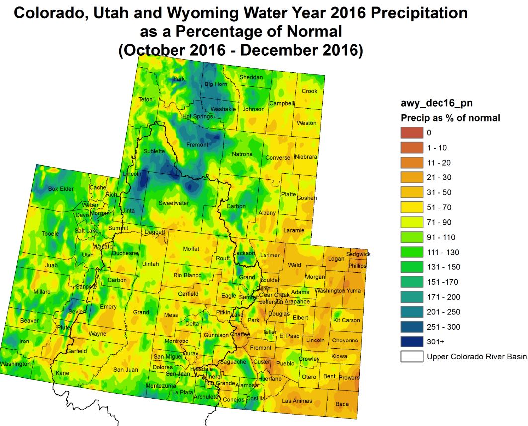
The West
Near to above normal precipitation on time scales ranging from 30 to 90 days or more prompted removal of the D2 areas in north-central and southeastern Colorado. Across the remaining areas of dryness and drought from the Rockies through the Intermountain West and Southwest, scattered to isolated areas of moderate to heavy precipitation weren’t enough to prompt any changes from last week. In contrast, very heavy precipitation ranging from 4 to 8 inches was recorded throughout the Sierra Nevada and isolated parts of the higher elevations in west-central and southwestern California. Elsewhere, 1.5 to 3.5 inches of precipitation fell in a swath from San Francisco southward to Monterey and eastward to the Sierra Nevada, and on areas along and near the eastern slopes of the Sierra Nevada, including part of western Nevada. Given the protracted nature of conditions from much of the San Joaquin Valley southward to Mexico, no improvement was introduced there, including the persistence of D4 conditions in part of southwestern California. In sharp contrast, all D0 to D3 areas in the central Sierra Nevada and adjacent west-central Nevada were improved this week as a pattern of well-above-normal precipitation continued…
Looking Ahead
During the next five days (January 19-23), above-normal precipitation (2-5 inches) is expected across most of the Gulf Coast states from far eastern Texas to and including northern Florida, most of the southern Atlantic Coast region, the Tennessee Valley, and southwestern portions of Kentucky and Virginia. Excessive precipitation amounts (liquid equivalents of 9-13 inches) are forecast for coastal California and most of the Sierras. These anticipated areas of heavy precipitation are likely to result in additional improvements to next week’s U.S. Drought Monitor depiction. Little if any relief, however, is forecast for most of the Great Plains and Northeast. For the ensuing five-day period (January 24-28), there are elevated chances for above-median precipitation across much of the contiguous U.S. However, odds favor below-median precipitation across the south-central states. Taking the two periods as a whole, Oklahoma and most of Texas are the least likely areas to receive beneficial precipitation.
Here’s the release from the US Department of Interior:
U.S. Secretary of the Interior Sally Jewell today issued a Secretarial Order directing the Department of the Interior and its bureaus to continue collaborative efforts to finalize important drought contingency actions designed to reduce the risk of water shortages in the Upper and Lower Colorado River Basins and build on recent progress to complete “Minute 32X” – a long-term Colorado River bi-national cooperative agreement with Mexico.
“I am proud of the tremendous progress we have made over the last eight years to work with our basin states, tribal and Mexican partners to address water resource challenges in the Colorado River Basin,” said Secretary Jewell. “With water from the Colorado River supporting the life and livelihood for an estimated 40 million people, it is absolutely critical for the Department of the Interior to continue to build on this progress and finalize these agreements.”
“The Department of the Interior has worked tirelessly with its partners to come to agreements to ensure that all the basin stakeholders move forward with coordinated plans to address the increasing challenges facing all Colorado River communities,” said Deputy Secretary Michael Connor. “This Secretarial Order ensures that Interior will continue to provide essential support for critical actions and paves the way to help carry these important agreements across the finish line.”
The Order describes hydrologic conditions in the basin and ongoing challenges associated with a 17-year period of historic drought and an ongoing deficit of available water compared to demands. Although water stored in reservoirs in the Colorado River Basin has protected the Basin from crisis during the current drought, those reservoirs are now at near-historic lows; basin-wide reservoir storage ended water year 2016 at just 51 percent of total capacity. In 2016, the lower basin narrowly avoided a shortage declaration, which would trigger mandatory cuts to water deliveries from Lake Mead. Although recent precipitation brought some relief to northern California, there has been no measurable improvement in the Colorado River System.
In addition to drought contingency actions and updating the water agreement with Mexico, the agreements referenced in the Secretarial Order will maintain significant hydropower production and associated financial support for critical environmental programs, and they will help protect Indian treaty rights and recognized water rights.
The Secretarial Order provides direction for Interior, particularly the Bureau of Reclamation, to continue work with the basin states, Indian tribes in the Colorado River Basin and Mexico to finalize these agreements during the first half of 2017. It calls for three actions:
1. Finalizing the Drought Contingency Plan. The order directs Reclamation to work with and support the efforts of the seven basin states and key principals of several water management agencies to finalize a Drought Contingency Plan that includes federal operations of Lower Basin facilities and proposed water conservation actions. Reclamation will participate in remaining negotiations and actions that are required to finalize agreements and provide information in support of any legislation that might be necessary to implement the final agreement.
2. Investing to Support Drought Contingency Actions. In connection with the order, Reclamation Commissioner Estevan López today executed an agreement with Governor Stephen Roe Lewis of the Gila River Indian Community to provide the community with $6 million for water conservation in fiscal year 2017 funding to acquire system water consistent with the drought plan to protect levels in Lake Mead. This agreement between Reclamation and the Community also sets the stage for future drought contingency planning to occur within Arizona.
On the agreement, Governor Stephen Lewis stated, “Our agreement with the Department of the Interior is an essential step toward a plan for comprehensively addressing Arizona’s pressing drought problem. The Community is working hard to try and create a framework that will work for all in the State and is pleased with this very successful first step in that right direction. We want to thank the Commissioner of Reclamation, Estevan López, and his entire team for their tireless efforts and we very much appreciate our cooperation with them. This is just the beginning, but it an essential first step, which hopefully will keep the momentum going in the days and weeks ahead.”
In addition, under the order, Reclamation will continue to invest in drought contingency actions such as the recent Salton Sea Memorandum of Understanding with the State of California. Interior also amended its current Memorandum of Understanding with the State of California to provide greater certainty on mitigation actions over the next decade.
3. Completing Minute 32X Negotiations with Mexico. The order directs Reclamation to continue to work with the International Boundary and Water Commission, the Republic of Mexico, the basin states and non-governmental organizations to finalize the bi-national cooperative agreement with Mexico – “Minute 32X.”
Over the past twenty years, collaboration between Interior and its bureaus along with American Indian tribes, the seven Colorado River basin states—Arizona, California, Colorado, Nevada, New Mexico, Utah, and Wyoming—and others has resulted in significant success in collaboratively addressing water resource challenges across the basin. Today’s order includes information on these important successes, while highlighting the need for prompt action to respond to historic drought conditions and the increasing risk to water supplies in the basin from climate change and other factors.
These successes include the Minute agreements Numbers 316 through 319 with Mexico; a historic 12 Indian water rights settlements totaling $3 billion in funding; historic water conservation agreements adopted in 2014 and a Memorandum of Understanding to strengthen coordination of management activities to benefit the Salton Sea.
The Obama administration’s senior western water leadership this afternoon announced a Colorado River water management package that appears intended to signal a bridge for the administration transition, to continue work on nearly-completed deals to reduce the draining of the river’s big reservoirs.
The package falls short of two major deals some had hoped to be completed before the current team left – a deal with Mexico over future Colorado River water sharing, and a set of agreements among US states and the federal government to reduce water use in the Colorado River Basin, protecting the river’s beleaguered reservoirs. But it suggests that those deals are now the subject of widespread and bipartisan agreement, and appears to create a framework for continuity as the deals’ final details are worked out, rather than a risk of a sudden change in direction as the new administration takes office Jan. 20.
The package is embodied in a “secretarial order” signed this afternoon by Sally Jewell that includes new data suggesting that, without action, the risk to Colorado River water supplies is growing. Absent action, according to the new Bureau of Reclamation modeling runs, there is a one in three chance of Lake Mead dropping below the critical elevation of 1,025 feet above sea level by 2026. At that level, drastic water supply cuts to be needed to keep the reservoir from dropping to dead pool.
With the proposed actions discussed in Jewell’s order, that risk drops to about a one in 16 risk, according to the new USBR analysis…
QUIET DIPLOMACY?
As with much in Washington right now, what happens next is shrouded in uncertainty. But the deal appears to reflect quiet diplomacy between the Obama team and the incoming Trump administration to create a bridge toward solving these problems as the government changes hands later this week. I didn’t have time to catch Interior nominee Ryan Zinke’s testimony yesterday, but I’m told that in response to questioning from Catherine Cortez Masto, Zinke testified favorably about the nearly completed “Drought Contingency Plan” described in Jewell’s secretarial order. If true (anybody who watched, feel free to jump into the comments and elaborate) that would provide evidence for my hypothesis that the bridge is being built to try to ensure continuity in the final steps of working out these deals, and that the incoming administration may look favorably on this stuff.
CONCRETE STEPS
Jewell’s announcement includes concrete steps toward a near term reduction in Colorado River water use, including an agreement to pay the Gila River Indian Community in Arizona $6 million this year to forebear water use, leaving the unused apportionment in Lake Mead. That’s a critical piece of Arizona’s part of the complex water saving deals now being negotiated. While the amount of water is relatively small, it fills a critical political and policy niche by demonstrating a new path to reduced water use in Arizona.
The deal also adds an addendum to an agreement between the federal government and the Salton Sea. Dealing with the Salton Sea is critical (see my Sacramento Bee piece from last month for details on why). Jewell’s move here is an effort to bolster efforts to deal with the Salton Sea problems, which is critical to winning support in return from the giant Imperial Irrigation District for the water use deals.
Jewell’s order also sets out an interesting set of steps to be implemented should further negotiations to finalize the water-saving agreements among the states fizzle, including this: “undertaking a review of the Secretary’s authorities under the Law of the River to implement policies that will reduce depletions in the Lower Basin”. Of course any order by the old Secretary of the Interior can be un-order by the new one, but this provides a threat in the background – if the states don’t work out the final details of a deal, the federal government should at least consider stepping in and ordering action to protect Lake Mead.
The Platte River is formed in western Nebraska east of the city of North Platte, Nebraska by the confluence of the North Platte and the South Platte Rivers, which both arise from snowmelt in the eastern Rockies east of the Continental Divide. Map via Wikimedia.
Selling 17 of his 21 water shares was the practical thing to do, even if Chuck Sylvester feels a little guilty.
“It’s bittersweet,” he said.
Sylvester and the Hays family, both of LaSalle, recently sold water shares to the city of Aurora. Sylvester feels guilty because of his ancestors. They not only owned the water, they helped dig part of the ditch with oxen — that’s how far back the ownership goes.
He didn’t say how much he made off the shares, but with the growing demand for water in municipalities and agriculture alike, shares are not cheap. Even so, the shares Sylvester sold were decreasing in value. Now was a good time to unload.
It’s rare for farmers to just sell their water, so when he approached the city of Aurora about buying shares, it was something officials weren’t going to turn down.
But those in Aurora are just in planning mode, accounting for an expected population increase within the next 40 years, according to Greg Baker, manager of Aurora Water public relations.
Since Aurora didn’t immediately need the 33 total shares — 17 of which were Sylvester’s — both families are leasing the water back from Aurora. This will allow the families to continue their operations as they’ve been.
The sale gives him a chance to continue farm operations for the time being. But how long he could sustain those crops is a bigger question, which prompted his decision to sell.
He said his inability to pump the land is leaving water under his property that makes the ground too soggy to grow crops. The state shut in more than 400 wells in 2006 to preserve groundwater in the South Platte Basin, and the rights of those who had seniority over the water. Junior rights-holders are at the mercy of the senior holders in a given year.
But since then, high groundwater has become a concern, and the state directive on preserving that groundwater hasn’t changed. With extra supply, that reduces demand, and therefore the price.
Sylvester said he doesn’t see the value going up anytime soon either. That’s why he decided now was the right time to sell.
“I see this getting worse and worse. I’m going to a state that has better water law,” Sylvester said.
Sylvester won’t be moving to Wyoming, but he plans to invest the profits into a farm out there to give a younger farmer a chance to stay in agriculture. Sylvester already owns three farms in Wyoming and plans to sell one of them. He said reinvesting in the next generation makes him feel less guilty about selling the shares.
While Sylvester wouldn’t reveal the price he fetched for the sale — which were South Platte River shares — he likely took home a nice nest egg…
Attempts to contact the Hays family about their reasons and plans were unsuccessful.
Until the water is needed in Aurora, the purpose will stay agricultural. When the leases are up, and city demand increases, officials will decide the water’s purpose — stay as is, or divert it for urban use.
If the water use stays as is, it’ll be used as a way to replenish the city’s current water source, or city officials can petition to get the water use changed for municipal use. The city wants the water either way, like most cities, for expected population increases.
It’s common for many cities to own water in areas away from the city. The city of Thornton in the 1990s [ed. purchase was in the 1980s] purchased water in the Pierce area, a water bank, of sorts, for future demand.
Here’s an excerpt from the The Pueblo Chieftain (Peter Roper):
The Colorado Public Utilities Commission voted unanimously Wednesday morning to keep the water in the Historic Arkansas Riverwalk of Pueblo by approving the transfer of Black Hills Energy’s water rights for its old Downtown power station to the Pueblo Board of Water Works and the city of Pueblo.
The transfer guarantees there will be an adequate flow of water in the HARP channel. The utility is giving the water rights to the Pueblo water board and all the gates and channels to the city…
In its response to Vaad and Epel, Black Hills officials said the water rights that were used to cool the old Power Stations 5&6 were so limited that the best use was to give them to the Pueblo water board to help support HARP.
Yes, there is still lots of ice in Antarctica, but it’s melting faster than ever. bberwyn photo.
FromUSA Today (Doyle Rice) via the Fort Collins Coloradoan:
The planet sizzled to its third straight record warm year in 2016, and human activity is to blame, federal scientists announced Wednesday.
The last time the world was definitely warmer than today? Some 125,000 years ago based on paleoclimatic data from tree rings, ice cores, sediments and other ways of examining Earth’s history, said NASA climate scientist Gavin Schmidt said.
The average temperature across the Earth’s land and ocean surfaces in 2016 was 58.69 degrees, a whopping 1.69 degrees above average, according to the National Oceanic and Atmospheric Administration (NOAA). It was largest margin by which an annual global temperature record has ever been broken, NOAA said.
Although less than 2 degrees above average may sound small, it’s quite a large number in climate science, where records are often broken by tenths or even hundredths of degrees.
A separate analysis of data from NASA concurred with NOAA’s findings. Most of the warming has happened in the past 35 years, and 16 of the 17 warmest years have occurred since 2001, NASA said.
Record high temperatures were set in 2016 on nearly every continent. No land areas were cooler than average for the year. Eight straight months (January through August) were also each the warmest since records began 15 years after the Civil War ended.
In a powerful testament to the warming of the planet, two leading U.S. science agencies Wednesday jointly declared 2016 the hottest year on record, surpassing the previous record set just last year — which, itself, had topped a record set in 2014…
NASA concurred with NOAA, also declaring 2016 the warmest year on record in its own dataset that tracks the temperatures at the surface of the planet’s land and oceans, and expressing “greater than 95 percent certainty” in that conclusion. (In contrast, NOAA gave a 62 percent confidence in the broken record.)
NASA actually found a bigger leap upward of temperatures in 2016, measuring the year as .22 degrees Fahrenheit warmer than the prior record year of 2015…
Last year “is remarkably the third record year in a row in this series,” said Gavin Schmidt, who directs NASA’s Goddard Institute for Space Studies, in a statement. “We don’t expect record years every year, but the ongoing long-term warming trend is clear.”
[…]
Scientists have been far less guarded. “2016 is a wake-up call in many ways,” said Jonathan Overpeck, a climate scientist at the University of Arizona, of the year’s temperatures. “Climate change is real, it is caused by humans, and it is serious.”
NASA and NOAA produce slightly different records using somewhat different methodologies, but have now concurred on identifying 2014, 2015, and 2016 as, successively, the three warmest years in their records. There was a noticeable difference this year in how much the two agencies judged that 2016 had surpassed 2015, with NASA more bullish — a difference that Schmidt attributed to different ways of measuring the super-warm Arctic on a press call Wednesday.
“The warming in the Arctic has really been exceptional, and what you decide to do when you’re interpolating across the Arctic, makes a difference,” Schmidt said.
But the differences between NOAA and NASA aren’t that significant, Schmidt further argued, in the context bigger picture. “Getting hung up on the exact nature of the records is interesting, and there’s lots of technical work that can be done there, but the main take home response there is that the trends we’ve been seeing since the 1970s are continuing and have not paused in any way,” he said.
Here’s a NASA figure showing that long term trend, now updated through 2016:
Last year’s warmth was partly enhanced by a strong weather pattern known as El Niño, but the scientists underscore that this is not the only cause. For example, 1998 was also, at the time, the warmest year on record thanks in part to a strong El Niño — but the 2016 planetary temperature now far surpasses that year. The reason is that the Earth has been warming since then, allowing another El Niño event, unlocking heat from the vast Pacific Ocean, to push overall temperatures to new heights.
Two other global agencies, the Japan Meteorological Agency and the U.K.’s Hadley Center, also track global temperatures. On Wednesday, the Hadley Center also announced that 2016 was the warmest year, albeit only “nominally” because it was very close to 2015 in the agency’s dataset. The center reported that while 2016 was .77 degrees Celsius above the temperature average between 1961 and 1990, 2015 was .76 degrees Celsius warmer.
“While the 2016 datapoint is stunning, please remember that these observed temperature departures … contain natural variability as well as the signal of human-caused Global Warming,” noted Michael Schlesinger, a climate scientist at the University of Illinois, of the Hadley Center data, which date back to 1850. Natural variability would include El Niño.
The difference between the Hadley Center and NASA once again comes down to the treatment of the Arctic, Schmidt explained.
“Our analysis demonstrates that the Arctic is warming around 2 to 3 times as fast as the global mean,” he said. “So that will be the cause of continuing divergences between the groups, and it ‘s something I think we all need to be thinking about.”
NASA further noted in its analysis that compared with the late 19th century, the planet has now warmed about 1.1 degrees Celsius, or 2 degrees Fahrenheit. That’s very significant because the global community has been striving to limit overall warming to considerably below a 2 degree Celsius rise, and even, if possible, to hold it to a 1.5 degree Celsius increase. That is now only about .4 degrees away, based on these figures.
“It is the second year in a row that the annual global temperature has been more than 1 Celsius degree warmer than the pre-industrial level, and shows that the world is moving ever closer to the warming threshold of 1.5 Celsius degrees, beyond which many scientists have concluded the impacts of climate change will be unacceptably dangerous,” said Bob Ward, who is director of policy and communications director at the Grantham Research Institute on Climate Change and the Environment, part of the London School of Economics and Political Science.
Last year’s warmth was manifested across the planet, from the warm tropical ocean waters off the coast of northeastern Australia, where the Great Barrier Reef experienced its worst coral bleaching event on record and large scale coral death, to the Arctic, where sea ice hit regular monthly record lows and overall temperatures were also the warmest on record, at least from January through September of 2016.
Among major 2016 events, the devastating bleaching of the Great Barrier Reef in 2016 did not stand alone. In a catalogue of some of the extremes the planet witnessed during the year, NOAA also noted the megafire that engulfed Fort McMurray, Canada, at the beginning of May, relatively early in the year for wildfires. That event was certainly consistent with a warming climate, as well as with the role of El Niño, although scientists are reluctant to formally say that climate change has played a role in an individual event without conducting extensive analysis.
Extreme high temperatures were seen from India — where the city of Phalodi recorded temperatures of 51 degrees Celsius (123.8 Fahrenheit) in May, a new national record — to Iran, where a temperature of 53 degrees Celsius (127.4 F) was recorded in Delhoran on July 22.
For the contiguous Unites States, 2o16 was merely the second warmest year on record, but for Alaska, it was the warmest yet recorded, underscoring once again the sharpness of Arctic warmth in particular.
The particular signature of warming in 2016 was also revealing in another way, Overpeck said, noting that the stratosphere, the layer of the planet’s atmosphere stretching from about 8.5 to 13.5 miles above us, saw record cold temperatures last year.
“The pattern of record warmth in the lower atmosphere, coupled with record cold in the stratosphere provides an clear fingerprint of the cause of the unprecedented warming – greenhouse gases trapping heat in the lower atmosphere instead of letting it escape to the stratosphere, and then to space. No doubt about it any more – humans, mainly by burning fossil fuels, are cooking the planet,” Overpeck said.
[This color-coded map displays a progression of changing global surface temperatures anomalies from 1880 through 2016. The final frame represents global temperature anomalies averaged from 2012 through 2016 in degrees Celsius.]
Earth’s 2016 surface temperatures were the warmest since modern recordkeeping began in 1880, according to independent analyses by NASA and the National Oceanic and Atmospheric Administration (NOAA).
Globally-averaged temperatures in 2016 were 1.78 degrees Fahrenheit (0.99 degrees Celsius) warmer than the mid-20th century mean. This makes 2016 the third year in a row to set a new record for global average surface temperatures.
The 2016 temperatures continue a long-term warming trend, according to analyses by scientists at NASA’s Goddard Institute for Space Studies (GISS) in New York. NOAA scientists concur with the finding that 2016 was the warmest year on record based on separate, independent analyses of the data.
Because weather station locations and measurement practices change over time, there are uncertainties in the interpretation of specific year-to-year global mean temperature differences. However, even taking this into account, NASA estimates 2016 was the warmest year with greater than 95 percent certainty.
“2016 is remarkably the third record year in a row in this series,” said GISS Director Gavin Schmidt. “We don’t expect record years every year, but the ongoing long-term warming trend is clear.”
The planet’s average surface temperature has risen about 2.0 degrees Fahrenheit (1.1 degrees Celsius) since the late 19th century, a change driven largely by increased carbon dioxide and other human-made emissions into the atmosphere.
Most of the warming occurred in the past 35 years, with 16 of the 17 warmest years on record occurring since 2001. Not only was 2016 the warmest year on record, but eight of the 12 months that make up the year — from January through September, with the exception of June — were the warmest on record for those respective months. October, November, and December of 2016 were the second warmest of those months on record — in all three cases, behind records set in 2015.
Phenomena such as El Niño or La Niña, which warm or cool the upper tropical Pacific Ocean and cause corresponding variations in global wind and weather patterns, contribute to short-term variations in global average temperature. A warming El Niño event was in effect for most of 2015 and the first third of 2016. Researchers estimate the direct impact of the natural El Niño warming in the tropical Pacific increased the annual global temperature anomaly for 2016 by 0.2 degrees Fahrenheit (0.12 degrees Celsius).
Weather dynamics often affect regional temperatures, so not every region on Earth experienced record average temperatures last year. For example, both NASA and NOAA found the 2016 annual mean temperature for the contiguous 48 United States was the second warmest on record. In contrast, the Arctic experienced its warmest year ever, consistent with record low sea ice found in that region for most of the year.
The planet’s long-term warming trend is seen in this chart of every year’s annual temperature cycle from 1880 to the present, compared to the average temperature from 1880 to 2015. Record warm years are listed in the column on the right. (Credit: NASA/Earth Observatory/Joshua Stevens)
NASA’s analyses incorporate surface temperature measurements from 6,300 weather stations, ship- and buoy-based observations of sea surface temperatures, and temperature measurements from Antarctic research stations. These raw measurements are analyzed using an algorithm that considers the varied spacing of temperature stations around the globe and urban heating effects that could skew the conclusions. The result of these calculations is an estimate of the global average temperature difference from a baseline period of 1951 to 1980.
NOAA scientists used much of the same raw temperature data, but with a different baseline period, and different methods to analyze Earth’s polar regions and global temperatures.
GISS is a laboratory within the Earth Sciences Division of NASA’s Goddard Space Flight Center in Greenbelt, Maryland. The laboratory is affiliated with Columbia University’s Earth Institute and School of Engineering and Applied Science in New York.
NASA monitors Earth’s vital signs from land, air and space with a fleet of satellites, as well as airborne and ground-based observation campaigns. The agency develops new ways to observe and study Earth’s interconnected natural systems with long-term data records and computer analysis tools to better see how our planet is changing. NASA shares this unique knowledge with the global community and works with institutions in the United States and around the world that contribute to understanding and protecting our home planet.
With a boost from El Nino, 2016 began with a bang. For eight consecutive months, January to August, the globe experienced record warm heat. With this as a catalyst, the 2016 globally averaged surface temperature ended as the highest since record keeping began in 1880, according to scientists from NOAA’s National Centers for Environmental Information (NCEI).
The average temperature across global land and ocean surfaces in 2016 was 58.69 degrees F or 1.69 degrees F above the 20th century average. This surpassed last year’s record by 0.07 degrees F. Since the start of the 21st century, the annual global temperature record has been broken five times (2005, 2010, 2014, 2015, and 2016).
Despite the cooling influence of a weak La Nina in the latter part of the year, the year ended with the third warmest December on record for the globe, with an average temperature 1.42 degrees F above the 20th century average.
In a separate analysis of global temperature data released at the same time, scientists from NASA also found 2016 to be the warmest year on record.
More noteworthy findings from 2016:
The globally averaged sea surface temperature was the highest on record, 1.35 degree F above average.
The globally averaged land surface temperature was the highest on record, 2.57 degrees F above average.
North America had its warmest year on record; South America and Africa had their second; Asia and Europe had their third; and Australia had its fifth.
The average Arctic sea ice extent for the year was 3.92 million square miles, the smallest annual average since record-keeping began in 1979.
The average Antarctic sea ice extent for the year was 4.31 million square miles, the second smallest annual average since record-keeping began in 1979.
FromThe New York Times (Justin Gillis and John Schwartz):
The data show that politicians cannot wish the problem away. The Earth is heating up, a point long beyond serious scientific dispute, but one becoming more evident as the records keep falling. Temperatures are heading toward levels that many experts believe will pose a profound threat to both the natural world and to human civilization…
The heat extremes were especially pervasive in the Arctic, with temperatures in the fall running 20 to 30 degrees Fahrenheit above normal across large stretches of the Arctic Ocean. Sea ice in that region has been in precipitous decline for years, and Arctic communities are already wrestling with enormous problems, such as rapid coastal erosion, caused by the changing climate.
“What’s going on in the Arctic is really very impressive; this year was ridiculously off the chart,” said Gavin A. Schmidt, head of the Goddard Institute for Space Studies in Manhattan, a unit of the National Aeronautics and Space Administration that tracks global temperatures.
But Arctic people were hardly alone in feeling the heat. Drought and starvation afflicted Africa. On May 19, the people in the town of Phalodi lived through the hottest day in the recorded history of India, 123.8 degrees Fahrenheit.
El Niño has now ended, and climate scientists almost universally expect 2017 to be cooler than the year before. But the scale of the heat burst has been startling to many of the experts, and some of them fear an accelerated era of global warming could be at hand over the next few years.
Even at current temperatures, billions of tons of land ice are melting or sliding into the ocean. The sea is also absorbing most of the heat trapped by human emissions. Those factors are causing the ocean to rise at what appears to be an accelerating pace, and coastal communities in the United States are spending billions of dollars to fight increased tidal flooding. Their pleas for help from Congress have largely been ignored.
The finding that a record had been set for the third year in a row was released on Wednesday by three government agencies, two American and one British, that track measurements made by ships, buoys and land-based weather stations. They analyze the figures to correct for known problems, producing an annual average temperature for the surface of the Earth. The national meteorological agency of Japan also confirmed the findings in a preliminary analysis.
The findings about a record-warm year were also confirmed by the Berkeley Earth Surface Temperature project, a nonprofit California group set up to provide a temperature analysis independent of governments. That group, however, did not find that three records had been set in a row; in its analysis, 2010 was slightly warmer than 2014.
In spite of a couple recent snowfalls, Morgan County has had a pretty dry couple of months.
From Thanksgiving Day until Tuesday, the county saw total precipitation of between 1 inch and 2.5 inches, according to data reported by the Community Collaborative Rain, Hail & Snow Network (CoCoRaHS). And there were some lengthy stretches of no rain, sleet or snow falling…
But while precipitation may be lagging in Morgan County, it has been coming down heavily in the mountains in recent weeks, according to the USDA Natural Resources Conservation Service.
As of Tuesday, the South Platte Basin was at 156 percent of snow water equivalent, the latest SNOTEL report showed. Since the 1980s, the Natural Resources Conservation Service has used snowpack telemetry to track the snowpack levels and then offers SNOTEL reports to the public, which then can be used forecast the water supplies that will be available through spring snowmelt.
One of the users of that data is Northern Colorado Water Conservancy District (Northern Water), which operates the Colorado-Big Thompson (C-BT)pipeline that brings water from the mountains to Fort Morgan.
Northern Water’s C-BT project involves 12 reservoirs, 35 miles of tunnels and 95 miles of canals on both sides of the Continental Divide in Northern Colorado, according to http://www.northernwater.org/.
Eventually, some of that snow up in the mountains makes its way to Fort Morgan through the pipeline, so snowpack well above 150 percent in January is a good sign for the city and all C-BT participants to have enough water this spring and summer.
“Late spring and early summer snowmelt and runoff from the Rocky Mountains provides most of Colorado’s water supply,” Northern Water’s website states. “Greater snowpack means favorable water supplies; lower amounts can signal an impending drought.”
High water content in the snowpack in New Mexico and Colorado bodes well for the spring runoff later this year.
“The snowpack is doing well,” National Weather Service meteorologist Brian Guyer said Monday. “So we’re going to have some runoff, finally.”
A good snowpack is welcome news, because New Mexico hasn’t had a good runoff since 2010. Last year was among the warmest on record, and a dry, windy spring robbed the state of much of its snowpack…
High-elevation areas of northern and central New Mexico have normal or above-normal snowpack, but the southern mountains are lagging, Guyer said.
Snowpack in the San Juan Basin around Chama is 177 percent of normal, packing 15 inches of liquid water, he said.
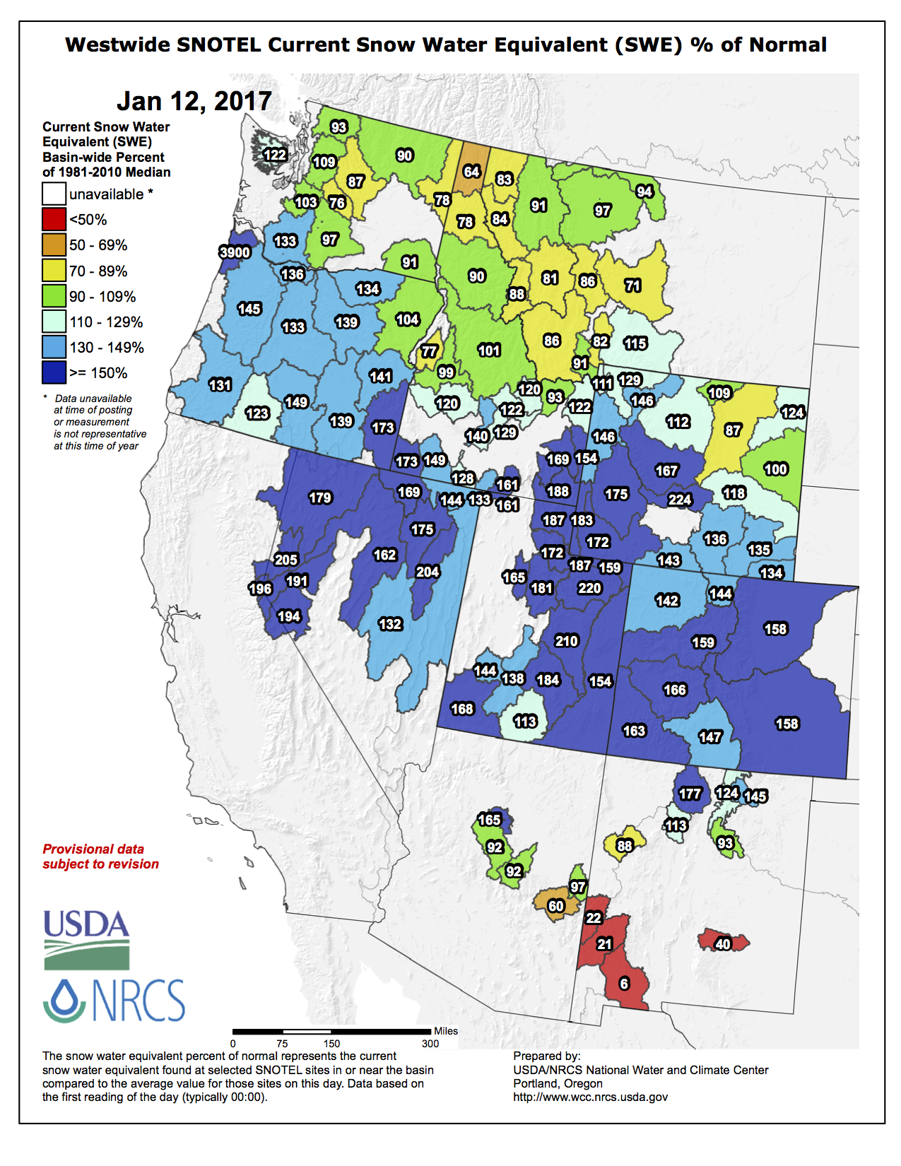
And here’s the Westwide basin-filled map for January 17, 2017 from the NRCS.
Westwide SNOTEL basin-filled map January 17, 2017 via the NRCS.
The next Aspinall Operations meeting will be held this Thursday, January 19th at the Holiday Inn Express in Montrose CO. The meeting will start at 1 PM.
A “get well soon” balloon floats in the contaminated waters of the Animas River flowing through Durango on Monday afternoon August 10, 2015 — photo The Durango Herald, Shane Benjamin
In November 2015, the U.S. Environmental Protection Agency’s Chief of Staff, Matt Fritz, established an agency team to conduct an After-Action Review of EPA’s response to the Gold King Mine (GKM) release that occurred on August 5, 2015. The team, comprised of employees from across the agency, interviewed over a hundred people and reviewed a large volume of documents to identify lessons learned and develop recommendations for the Administrator’s consideration. Among the documents reviewed were after-action reports from previous emergency responses, which showed that some of the issues identified at Gold King Mine were not new. On December 21, 2015, the After-Action Review Team submitted its report detailing ten specific recommendations to improve how the agency responds to emergency incidents and to ensure a highly effective EPA Emergency Response Program that can adapt quickly to dynamic, unpredictable situations. These recommendations, shown in Appendix A, were:
Recommendation 1: Establish a National Incident Management Assistance Team (IMAT) at EPA.
Recommendation 2: Institute Senior Official training plan.
Recommendation 3: Institute ICS key leadership training plan.
Recommendation 4: Establish an agency data and information management team.
Recommendation 5: Improve data and information posting and communications.
Recommendation 6: Establish Communications Strike Teams and broaden data training for PIOs and public affairs staff.
Recommendation 7: Invest in data resources and clarify roles/responsibilities.
Recommendation 8: Build capacity for rapid data collection, interpretation, and dissemination.
Recommendation 9: Align public affairs resources and update communications procedures.
Recommendation 10: Improve notification procedures, plans, and equipment.
The EPA outlined its efforts in a report posted on its website late Friday afternoon called “In the Rearview Mirror: Implementation of the Gold King Mine After-Action Review.”
The EPA’s chief of staff announced the changes in February 2016, after the agency took responsibility for the release of metal-laden water from the Gold King Mine on Aug. 5, 2015.
The changes were based on a December 2015 after-action report that made 10 recommendations focused on improving its emergency response and communications that the EPA has worked on, the review stated. The original after-action report did not seem to have been posted on the EPA’s website when it was finished. EPA officials did not immediately respond to request for comment on the review Saturday.
The review recommended the agency continue funding emergency management training and positions created as a result of the changes. But it did not list specific budget expenses.
A national emergency response team was trained by December 2016 and it will be deployed to mine spills or releases that the EPA has caused or is directly involved in, or when an event involves multiple EPA regions.
“Quick and effective response to incidents reduces the risk to public safety, environmental damage and potential legal liability,” the report said.
To improve communications, the EPA plans to develop three teams of six that will assist with breaking down complex and technical information. When a team is deployed, they will not communicate with the public but will work behind the scenes.
Assistant County Manager Joanne Spina could not comment on the report, but she acknowledged that there were challenges with EPA communications after the Gold King Mine spill.
“We tried to work through those as situations arose,” she said.
During emergencies, the EPA also plans work with federal, state, local, tribal, trust territory and other partners on development and release of all materials.
Effectively communicating data with the public was another focus of the EPA, and it calls for eliminating the time lag between the EPA receiving data and communicating it to the public.
Residents and local officials were frustrated with the slow pace of metals sampling and interpretation of the data.
This data was needed to determine whether the river could be reopened and used for drinking, agriculture and recreation.
Distrust of the EPA’s data led some residents of the Navajo Nation to keep their irrigation ditches closed, causing lost crops, because they didn’t want to risk using the contaminated water.
The Office of Emergency Management has hired a coordinator to help the EPA with data, and the review solicits funding for training and workshops.
Agency workers also updated their contact lists for tribal governments and plan to update those lists annually.
The agency also updated training for senior leadership on what their role is during an emergency. Satellite communications systems were also upgraded for those working in the field.
After the spill, the EPA team was trapped without cellphone service or a satellite phone and this delayed communications with the state by almost two hours.
Many Indian reservations are located in or near contentious river basins where demand for water outstrips supply. Map courtesy of the Bureau of Reclamation.
Here’s the release from Secretary Jewell’s office:
As part of President Obama’s historic commitment to empowering tribal nations, U.S. Secretary of the Interior Sally Jewell and Interior Deputy Secretary Michael L. Connor today joined tribal leaders to celebrate four landmark water rights settlements that will resolve contention among tribes and neighboring communities over water rights and improve the quality of life for tribal communities and their non-Indian neighbors.
The settlements, negotiated during the past eight years, were ratified and approved in December 2016 under the Water Infrastructure Improvements for the Nation Act. The legislation authorized $422 million in funding to the Blackfeet Tribe of Montana to provide clean drinking water and other water-related infrastructure projects that will improve the health, safety and welfare of the Tribe. More than $28 million was authorized for the Pechanga Band of Luiseño Mission Indians, located in southern California, enabling them to gain secure water supplies. The legislation secured for the Choctaw and Chickasaw Nations of Oklahoma the right to use and benefit from water resources within their historic treaty territories without any federal funding. Finally, the five San Luis Rey Bands of southern California settlement legislation finalized and effectuated a settlement originally enacted in 1988 and did not require additional funding.
“With these four agreements, the Obama Administration has completed a dozen landmark Indian water rights settlements – more than any previous administration – that put an end to complex and litigious water rights controversies for 20 tribes in New Mexico, Arizona, Montana, California and Nevada,” Secretary Jewell said. “Today’s celebration marks not only these incredible accomplishments, but the start of a new journey working together to implement these hard-won settlements.”
The total $3 billion in funding authorized for Indian water rights settlements during the current Administration represents a major commitment to help provide safe drinking water and support economic development activities, including hydroelectric power, agriculture improvement and water marketing.
“The settlements, which have been a top priority of this Administration, represent the culmination of generations of hard work and dedication by the tribes and their neighbors,” said Deputy Secretary Connor. “Each of the settlements had widespread local and bipartisan congressional support, and implementing the agreements will bring much needed investments to Indian country, help stabilize water supplies in various communities, and improve water resources management for all concerned, including non-Indian communities.”
The Blackfeet settlement reflects decades of struggle and commitment by the Tribe – and negotiations with the State of Montana – to quantify and secure a tribal water right of more than 800,000 acre-feet while protecting the rights of existing water users. The settlement includes funding for the Tribe to develop and manage its water resources.
The Pechanga settlement, which will partially settle litigation filed by the United States in 1951, was achieved only after a long and arduous struggle. The Pechanga Band negotiated the settlement with its neighbors, the Rancho California Water District, Eastern Municipal Water District and the Metropolitan Water District. The Band has tirelessly pursued the quantification of its water rights and engaged its neighbors in a multi-year process of building mutual trust and understanding. The resulting settlement benefits all of the parties, securing adequate water supplies for tribal members and encouraging cooperative water resources management among all parties.
The Choctaw and Chickasaw settlement in Oklahoma – the first Indian water settlement to be finalized in that state – reflects a unique and collaborative approach to water management in the Nations’ historic treaty territories. It will advance a collaborative approach to water management and help achieve water security for the State of Oklahoma and the Choctaw and Chickasaw Nations. The settlement includes important protections for the Nations’ future and existing water rights, conserves water resources and provides for cooperation in the regulation of water use.
The San Luis Rey settlement allows full implementation of amendments to the 1988 San Luis Rey Indian Water Rights Settlement Act that benefits the La Jolla, Rincon, San Pasqual, Pauma and Pala Bands of Mission Indians in southern California. The agreement allows the five Bands and the local parties to realize the full benefits of the 1988 Act, including: expressly recognizing the continuing federal reserved water rights of the Bands; addressing the fair allocation of water among the Bands; protecting the water rights of allottees; waiving all past claims the Bands may have against the U.S. regarding water rights and breach of trust relating to water rights; and allowing the Bands to access a trust fund established in 1988 that has now grown to approximately $60 million.
“These settlements recognize tribal stakeholders’ reserved rights to one of their most precious assets and offer the most efficient way of providing vital water supplies to both tribal and non-Indian communities,” said Interior Principal Deputy Assistant Secretary – Indian Affairs Lawrence S. Roberts. “Under the Obama Administration, Indian water rights settlements are a visible example of the Federal trust responsibility to federally recognized tribes and of Federal policies that promote tribal sovereignty, self-determination and economic self-sufficiency. I congratulate all of the parties to these settlements for their leadership in achieving these settlements.”
The eight other settlements enacted during the Obama Administration were:
Navajo-Gallup Water Supply Project and Navajo Nation Water Rights Settlement
Shoshone-Paiute Tribes of the Duck Valley Reservation Water Rights Settlement
Crow Tribe Water Rights Settlement
White Mountain Apache Tribe Water Rights Settlement
Aamodt Litigation Settlement
Taos Pueblo Indian Water Rights Settlement
Bill Williams River Water Rights Settlement (Hualapai Tribe)
Pyramid Lake Paiute Tribe – Fish Springs Ranch Settlement
Thoughtful Indian water rights settlements benefit taxpayers when balanced against the potential consequences and costs of continued litigation over Indian water rights claims. Settlements also offer the most efficient way to provide much-needed water supplies to tribal communities in fulfillment of basic Federal trust responsibility to American Indians and Federal policy promoting tribal sovereignty, self-determination and economic self- sufficiency.
Settlements are especially important given the need for water on many Indian reservations and throughout the West and the uncertainty regarding its availability due to drought, climate change and increasing demands for this scarce resource. Settlements resolve long-standing claims to water; provide reliability with respect to supplies; facilitate the development of much-needed infrastructure; improve environmental and health conditions on reservations; and promote collaboration between Tribes, states and local communities.
From the Indian Country Media Network (Vincent Schilling):
On Friday, January 13, U.S. Secretary of the Interior Sally Jewell and Deputy Secretary Michael L. Connor joined with tribes and members of Congress to celebrate the enactment of four historic Indian water rights settlements that will benefit nine tribes.
The celebration included leaders from the Blackfeet Tribe, the Choctaw and Chickasaw Nations, the La Jolla, Rincon, San Pasqual, Pauma and Pala Bands of Mission Indians, and the Pechanga Band of Luiseño Mission Indians.
U.S. Congressman Tom Cole was also in attendance, along with a number of tribal leaders.
During the announcement and celebration, Interior Secretary Sally Jewell thanked the leaders of the tribes in attendance and informed the attendees that the Obama Administration has reached more water settlements than any administration in history.
“With these four agreements, the Obama Administration has completed a dozen landmark Indian water rights settlements – more than any previous administration – that put an end to complex and litigious water rights controversies for 20 tribes in New Mexico, Arizona, Montana, California and Nevada,” Secretary Jewell said. “Today’s celebration marks not only these incredible accomplishments, but the start of a new journey working together to implement these hard-won settlements.
“The settlements, which have been a top priority of this Administration, represent the culmination of generations of hard work and dedication by the tribes and their neighbors,” said Deputy Secretary Connor.
“Each of the settlements had widespread local and bipartisan congressional support, and implementing the agreements will bring much needed investments to Indian country, help stabilize water supplies in various communities, and improve water resources management for all concerned, including non-Indian communities.”
The U.S. Drought Monitor, in a report Thursday, showed the level of abnormal dryness and moderate drought decreasing in an area that spans the Front Range to the Kansas border. Still, more than half of Colorado remains classified as unusually dry, some 35 percent in moderate drought and about 2 percent — in Larimer County and the Eastern Plains — in severe drought.
The monitor’s report, however, only takes into account data through Wednesday, leaving the growing amount of high country precipitation since then out of the mix.
“Major drought improvements were made not only to California but at many areas of the West, including parts of Nevada, Utah, Oregon, Idaho, Montana, Wyoming, and Colorado,” the report said. “The decent snowpack should greatly contribute to a good spring snow melt runoff and recharge if conditions are maintained.”
The Natural Resources Conservation Service reports as of Wednesday that Colorado’s statewide snowpack level is 157 percent of the normal and at 148 percent as compared to last year. The snowpack so far this year is far above what it has been measured at on the same date dating back to 2014.
Officials say the snow that has hit Colorado this week stems from the Atmospheric River — also known as the Pineapple Express — which carries moisture across the West from the Pacific Ocean.
“This is a really unusual event,” Ethan Greene, director of the Colorado Avalanche Information Center, said earlier this week. “It has to do with the amount of snow and the water content of that snow and how it’s come in. We’re seeing areas like Wolf Creek Pass and Vail Pass that are getting 5 inches or 8 inches of water. That’s just a huge amount of weight that’s going onto our snowpack.”
Colorado Drought Monitor January 10, 2017.
From the Fort Collins Coloradoan (Jacy Marmaduke):
Just as hope waned, the high-pressure ridge began to break down, allowing the jet stream to meander into Colorado’s mountains and fill them to and in some place over the brim with snow. Several snowstorms have dropped 5 to 8 feet of snow since mid-November. And it’s been good, wet snow, too, which is even better for spring runoff.
South Platte Basin snowpack sat at 158 percent of normal Thursday morning. Statewide, we’re at 155 percent. The statewide rate of snowpack accumulation between Nov. 17 to Jan. 1 was the fastest Colorado has seen in 32 years, according to the Natural Resources Conservation Service.
Westwide SNOTEL basin-filled map January 16, 2017 via the NRCS.
Photo credit Upper Yampa River Water Conservancy District.
Here’s a report from a tour of Stagecoach Dam from Matt Stensland writing for Steamboat Today. Click through for the cool photo of the drain system from inside the dam. Here’s an excerpt:
It is a careful balancing act at the Stagecoach Dam, where electricity is generated for homes, fish habitat is managed and water is stored for a time when cities, ranchers and industry need it.
Behind the steel door, mineralized sludge covers the concrete walls and incandescent bulbs dimly light the narrow corridor.
These are the guts of the Stagecoach Dam southeast of Steamboat Springs, and it can be a little unnerving knowing that at the other side of the wall, 9,360 pounds of pressure push against each square foot of concrete.
Water drips from the ceiling and falls from drain pipes that collect water from the seeping concrete.
“All dams get water into them,” said Kevin McBride, adding that not having a system to drain the water would create pressure and put the dam’s integrity at risk…
“It’s pretty much paradise here,” said Blankenship, who most recently worked at a coal mine and previously worked in the power house of the USS Enterprise for the U.S. Navy.
Rogers has an electrical engineering degree from the Colorado School of Mines.
In addition to monitoring the integrity of the dam, they oversee the hydroelectric power plant, which was named the John Fetcher Power Plant in 1997. He pushed to make electricity generation part of the dam design.
“I think John was a natural conservationist and to have this capability in a project that size and not do it was a bad thing,” said McBride, referring to Fetcher, who died in 2009 at age 97 after being recognized as one of the state’s water leaders.
Above the loud turbine in the power house sits a sign warning people not to stand underneath. That is because above, there is a large, weighted steel lever that will come crashing down if the power generated at the plant needs to immediately come off the grid.
On Tuesday afternoon, the electrical turbine was generating upwards of 500 kilowatts. The system can generate as much as 800 kilowatts, but generation is limited by the amount of water that is flowing into the reservoir.
“The generation, it fluctuates wildly,” said Andi Rossi, the water district’s engineer. “If the flows get too low, we shut down for power generation. In a big wet year, we’ll make a lot of power.”
The water district had been selling the power to Xcel Energy, but Yampa Valley Electric Association began buying the power last year for six cents per kilowatt hour. In 2016, YVEA paid more than $230,000 for the 3.85 million kilowatt hours generated at the dam. That is enough energy to power about 355 homes.
Power generation varies and is dependent on runoff. During the drought year of 2002, only 1.85 million kilowatt hours was produced. When there was abundant snowfall in 2011, 4.7 million kilowatt hours was produced. Since 1999, an average of 3.8 million kilowatt hours has been made each year…
A tower of concrete in the reservoir beside the dam has three gates that allow different temperatures of water to be mixed and sent through a pipe under the dam toward the generator.
From there, the water is either sent through the generator or through a pipe called a jet flow, which shoots water out of the power plant and helps oxygenate the water for fish habitat in the section of river in front of the dam known as the tailwaters.
The area is an angler’s delight and can only be accessed by snowmobile from the Catamount area or by hiking along a county road from Stagecoach State Park.
“It’s phenomenal,” Colorado Park and Wildlife fish biologist Billy Atkinson said.
With improvements by Parks and Wildlife to the river habitat, the area has thrived for fishing, partly because of the dam and reservoir. Relatively warm water released from the dam keeps the section of river from freezing over, and the water from the reservoir is rich in nutrients for the fish.
“The system is very productive,” Atkinson said.
In 2016, 25 percent more people visited the section of river, and 4,000 trout were measured per mile.
Not all tailwaters below dams in Colorado are experiencing similar success.
“It depends on the dam and the operations of the dam,” Atkinson said.
Say hello to WildWorldCreative.com. They’re VR art show is Thursday, February 6, 2017, Syntax Psychic Opera – 554 South Broadway – Denver CO. Click on the link to register and to view the multi-media. Here’s an excerpt:
Robert F Kennedy, Jr. calls our access to water “the biggest environmental and political challenge of our time.” Four hundred million people depend on it, yet there’s little conversation happening about it. The artists will be painting in VR to demonstrate how water will be one of the forces that will drive much of 21st century history.
The state and federal agencies told a judge Thursday that they support the Lower Arkansas Valley Water Conservancy District’s request to have a courtroom voice in a clean-water lawsuit against Colorado Springs.
The Colorado Department of Public Health and Environment and the U.S. Environmental Protection Agency are suing the city, which discharges pollutants into Fountain Creek and other tributaries.
The Lower Ark district wants to join the case as an intervenor to protect the district’s interest during the litigation…
Senior Judge Richard Matsch is presiding over the case in U.S. District Court in Denver and will decide whether to grant Lower Ark’s request.
The EPA and the state health-environment department filed the lawsuit Nov. 9. It alleges that Colorado Springs’ storm sewer system is violating federal and state clean water laws.
The city denies it is violating the laws. Mayor John Suthers recently pointed to additional expenditures the city is making as an example of its commitment to correct storm water problems.
The storm water contains pollutants, including E. coli, that flow into the river from creek tributaries.
The district encompasses Bent, Crowley, Otero, Prowers and Pueblo counties, where considerable produce, including Rocky Ford melons, are grown.
In Thursday’s court filing reviewed by The Pueblo Chieftain, the EPA and the department told Matsch they agree with Lower Ark that it should have a voice in court because the district wants the river water to have adequate quality.
To achieve that, the agencies and the district want Colorado Springs to reduce the amount of polluted discharges.
The environmental agencies contend Colorado Springs mischaracterizes the lawsuit as being focused on past issues, but it in fact “seeks to remedy current and ongoing violations.”
The environmental agencies disagree with Colorado Springs’ arguments that the district has no legal right to become an intervenor and that intervention will unduly complicate the litigation.
The lawsuit seeks a court order requiring the city “to develop, implement and enforce” its stormwater management program, as required by permits the government has issued. The lawsuit goes on to ask a judge to impose monetary penalties on Colorado Springs for the violations.
“To have our snowpack where it is right now for the state is a really good position to be in going forward for water supplies into the spring and summer,” said Brian Domonkos, Colorado snow survey supervisor and hydrologist…
According to Domonkos, a strong snowpack is great news for farmers and water utilities, though it could change in the next few months.
“At this point we are about 50 percent done with our snow accumulation season. We could dry out to some degree, and we may not be quite as high for snowpack when the peak snowpack comes around in late April early May,” he said.
Colorado could see a record snowpack this spring — a situation Domonkos said was unimaginable in just November — but it could come with a price.
“As with any year that you have high snowpack, it all depends on how it melts,” he said.
“If it melts gradually that’s more what you want to see. Soils become saturated and then you can have a nice steady runoff and that provides a steady water supply through the summer.”
But under the right conditions, flooding could pose a problem later in the year for parts of the state.
“If we have a very high snowpack late into spring and then off a sudden temperatures warm up really quick and we have potential rain on snow events, then we can worry about very high [stream and river] flows,” Domonkos said.
At this point in the season, reservoirs across Colorado are at average levels. If they fill up too early, in the season more water will be sent downstream.
Colorado snowpack just saw its fastest turnaround in more than 30 years.
That’s a big deal for Fort Collins, which mainly relies on snowpack for its water supply and has been in a severe drought since August.
The story sounds like something out of a heartwarming underdog movie: By Nov. 17, 2016, Colorado’s water year was off to the worst start in more than three decades as a stubborn high-pressure ridge remained camped out over the Front Range. Snowpack in the South Platte River Basin, which supplies much of Fort Collins’ water, was about half of the average amount.
Just as hope waned, the high-pressure ridge began to break down, allowing the jet stream to meander into Colorado’s mountains and fill them to and in some place over the brim with snow. Several snowstorms have dropped 5 to 8 feet of snow since mid-November. And it’s been good, wet snow, too, which is even better for spring runoff.
South Platte Basin snowpack sat at 158 percent of normal Thursday morning. Statewide, we’re at 155 percent. The statewide rate of snowpack accumulation between Nov. 17 to Jan. 1 was the fastest Colorado has seen in 32 years, according to the Natural Resources Conservation Service…
Heavy snowpack is great for spring water supply, agriculture and winter recreation. But [Treste Huse] can’t help but worry just a little about enhanced flood risk. If inordinately high snowpack persists, rivers like the Poudre and the Big Thompson are in for major runoff come spring.
That’s not coming anytime soon, though, so conditions can — and likely will — change. Huse said NWS predicts a decent chance of normal or above-normal precipitation during the next few months.
“It’s been a roller coaster ride,” she said of Colorado’s snowpack. “You never know what’s gonna happen next.”
George Washington addresses the Continental Congress via Son of the South
FromThe Grand Junction Daily Sentinel (Dennis Webb):
U.S. Rep. Scott Tipton is hoping to play a bigger legislative role on natural-resource issues facing Colorado and the West as a result of a committee appointment announced Friday.
Tipton, R-Colo., learned he will serve on the House Committee on Natural Resources for the next two years, returning to a panel he was a part of from 2011 to 2014…
“I’m honored and excited to be back on the Natural Resources Committee, which has jurisdiction over many of the issues that impact the Third District of Colorado on a daily basis,” he said in a news release. “While I’ve continued to push for policies that protect water and private property rights, and support responsible energy development and public land management as Vice Chair of the Western Caucus, I’m pleased to have more of a direct role in the legislative process surrounding issues like these and many others.”
[…]
While previously on the Natural Resources Committee, Tipton introduced the Small Conduit Hydropower Development and Rural Jobs Act, which Congress passed and President Obama signed into law.
He long has fought what he says are the federal government’s attempts to circumvent state water law, seeking passage of his Water Rights Protection Act. Repeatedly passing the House, that measure has yet to be taken up by the Senate.
Other natural-resource legislative initiatives Tipton has been pushing have included a bill he says would foster healthy forest management and help the state of Colorado protect communities from wildfires on national forests.
He also has advocated what he calls an all-of-the-above approach to energy development, involving both traditional and renewable energy sources.
This image was taken during the peak outflow from the Gold King Mine spill at 10:57 a.m. Aug. 5. The waste-rock dump can be seen eroding on the right. Federal investigators placed blame for the blowout squarely on engineering errors made by the Environmental Protection Agency’s-contracted company in a 132-page report released Thursday [October 22, 2015]
FromThe Farmington Daily Times (Magdalena Wegrzyn , Leigh Black Irvin , Joshua Kellogg and Noel Lyn Smith):
Federal lawmakers, tribal leaders and state and local officials presented a rare unified front today as they vehemently denounced the U.S. Environmental Protection Agency’s announcement that it will not pay more than $1.2 billion in claims filed against it in response to the Gold King Mine spill.
The EPA said the Federal Tort Claims Act prevents the agency from paying claims that result from “discretionary” government actions. Congress passed the law to allow government agencies — and in this case, contractors working on their behalf — to act “without the fear of paying damages in the event something went wrong while taking the action,” according to a press release from the EPA.
Three federal lawmakers representing New Mexico denounced the news in a joint statement, calling the agency’s reasoning a “shameful legal interpretation of liability.” Meanwhile, Navajo Nation officials questioned who would take responsibility for reimbursing tribal members hurt by the spill, which on Aug. 5, 2015, released more than three million gallons of toxic wastewater into a tributary that feeds the Animas River, which flows into the San Juan River, ultimately emptying into Lake Powell.
The EPA said the work contractors conducted at the mine near Silverton, Colo., is considered a “discretionary function” under the law.
Sens. Tom Udall and Martin Heinrich, New Mexico Democrats, and Rep. Ben Ray Luján, D-N.M., issued a statement saying they would continue pushing for legislation to hold the EPA accountable. They also said it would be up to the courts to determine whether the EPA’s defense is legitimate.
Heinrich said in a phone interview that he intends to introduce legislation to ensure the EPA pays claims that have already been filed, as well as future claims.
“I’m going to speak to all of the senators from Colorado and Arizona, and we’re going to introduce legislation to do this right,” he said.
An EPA agency official said paying the claims would discourage cleanup efforts — such as the one being conducted at the Gold King Mine when it was breached — in the future…
Navajo Nation President Russell Begaye said the tribe will continue pursuing its lawsuit against the EPA and several other entities. He said the tribe plans to work with president-elect Donald J. Trump’s administration to address claims tied to the spill.
“It doesn’t stop here,” Begaye said shortly after attending an inauguration ceremony in Shiprock for recently elected Northern Agency chapter officials. “This is one step, and we will continue taking the next step and if we have to, we’ll take it all the way to the Supreme Court.”
[…]
An EPA official said 73 claims related to the mine spill were filed under the Federal Tort Claims Act. Four were from governmental agencies and the rest were from individuals and companies…
Joe Ben Jr. served as the Shiprock Chapter’s farm board member when the spill occurred. Ben, a farmer himself, said he did not file a claim but knows several other farmers who submitted claims for lost crops and revenue…
The orange plume flows through the Animas across the Colorado/New Mexico state line the afternoon of Aug. 7, 2015. (Photo by Melissa May, San Juan Soil and Conservation District)
… collecting compensation doesn’t weigh heavily on [Earl] Yazzie. Instead, the farmer said he’s more concerned about whether to plant crops this spring and if he’ll irrigate with water from the San Juan River…
Included in the $1.2 billion is about $154 million in tort claims that are part of a lawsuit filed by the state of New Mexico, according to the EPA official. She said the EPA’s defense will be used in court to deny payment of those claims…
The EPA official acknowledged the announcement was slow in coming, adding “we spent a lot of time trying to see if there was any other way to address this because this is obviously an answer that leaves a lot of people unhappy who have been hurt.”
The EPA said the claims could be refiled in federal court, or Congress could authorize payments.
But attorneys for the EPA and the Justice Department concluded the EPA is barred from paying the claims because of sovereign immunity, which prohibits most lawsuits against the government.
“The agency worked hard to find a way in which it could pay individuals for damages due to the incident, but unfortunately, our hands are tied,” EPA spokeswoman Nancy Grantham said.
The EPA said it has spent more than $31.3 million on the spill, including remediation work, water testing and payments to state, local and tribal agencies.
A team at CU Boulder is partnering with researchers in Illinois and Indiana to pull snow from the skies — and they’ll only be the latest from Colorado to experiment with the weather. Read on for the details of the new project and the backstory of this state’s ongoing weather modification program.
The research project, launched this month, will put planes over southwest Idaho to seed silver iodide into the clouds, potentially causing snow and ice to form when it wouldn’t otherwise.
This thing has a great name, by the way: SNOWIE, or Seeded and Natural Orographic Wintertime Clouds — the Idaho Experiment. If it works, it would increase the amount of springtime water runoff to streams and rivers, providing more power from hydroelectric dams.
The idea is to build up “the scientific foundation for weather modification,” said assistant professor Katja Friedrich, who’s in charge of the CU part of the program, in a news release.
Among other contributions, two Boulder students will be operating a Doppler radar system on a mountain to track the effects of the experiment. The team also will be operating various gauges and instruments to keep track of the project, joining colleagues from the University of Wyoming and the University of Illinois-Urbana Champaign.
The data, in turn, will be the basis for scientific research by students at CU and elsewhere, and a few lucky undergrads will even get the chance to spend a week at the site.
As of Jan. 10, the experiment had flown three times in four days.
But this isn’t new for Colorado:
The state of Colorado itself has been experimenting with the technology since the 1970s. There’s an entire weather modification program to explore the concept at a cost of about $1 million per year, paid for in part by water providers and ski resorts. Unlike the new research program in Idaho, Colorado uses ground-based “generators” that burn silver iodide up into the air when conditions are just right.
Vail and Beaver Creek have the longest-running effort, which tries to get the resorts open earlier and for a longer season. There are seven active programs in Colorado, according to the Colorado Water Conservation Board.
The state claims these programs have showed promise. One research report estimated that 8 percent of the snowpack at Winter Park in one recent season may have been “gained from cloud seeding.”
(The state also has permitted “hail cannons,” which use the power of sound to try to disrupt hail clouds in Weld County and the San Luis Valley.)
Still, it’s quite hard to reliably measure the impact of these programs. Nolan Daesken, the state climatologist, believes they have some effect but that claims about them sometimes are overblown, according to the Colorado Independent.
Silver iodide can only draw out significant snowfall when temperatures are below 17 degrees, “with sufficient moisture in the air and favorable winds,” as Hannah Holm, coordinator for the Water Center at Colorado Mesa University, wrote for Vail Daily.
Her conclusion: Cloud-seeding deserves respect as a new water supply strategy, but it’s a relative drop in the bucket.
Click here to read the newsletter. Here’s an excerpt:
Across the country, drinking water crises are making the news—from toxic algae to lead poisoning to a growing number of communities facing contamination from a class of manmade chemicals known as perfluorinated compounds or PFCs—raising concerns about whether the nation’s current drinking water regulations do enough to protect us.
While there are clear rules pertaining to 93 federally regulated drinking water contaminants, there are no national drinking water standards for algal cyanotoxins, PFCs, or a host of other potentially harmful unregulated contaminants of emerging concern.
Read this article and more in the recently-released issue of Headwaters magazine, where we explore the connection between public health and water, the regulations in place to keep us safe, and the question of whether those go far enough.
Back in September, Denver7 First Alert Weather Chief Meteorologist Mike Nelson projected Colorado would probably see a La Niña-type winter: A system that favors the northern mountains of Colorado with an abundance of snow.
Nelson predicted that the Denver area could see about 60 inches of snow while Foothill locations could see up to 100 inches of snow through early May.
Whether that ends up happening is still up in the air, but again, the snowfall totals in the mountains point to good prospects…
Colorado’s 2017 “water year” started off slow — really slow, according to National Resources Conservation Service (NRCS) officials.
“From the beginning of the water year through November 17th, 2016, statewide Colorado snowpack was off to the worst start in over 25 years at 6% of normal and year-to-date precipitation,” said Brian Domonkos, a snow survey supervisor for the Natural Resources Conservation Service.
But things changed quickly after Nov. 17.
“From November 17th, 2016 through January 1st, 2017 snowpack in the mountains grew at the fastest rate dating back to 1986, with an [sic] statewide gain of 7.4 inches of snow water equivalent,” said Domonkos. “That increase is greater than 1997, 2008, and 2011 for the same period in perspective years.”
Domonkos went on to say, “As of January 1st, 2017, Colorado statewide snowpack is a healthy 114% of normal, riding in on the back of a December which saw 171% of normal precipitation.”
Arapahoe Basin and Loveland ski areas each reported 11 inches Sunday to Monday, and Breckenridge Ski Resort noted a respectable half-foot as well. Both Copper Mountain and Keystone resorts touted a very healthy 9 inches over that same time. The month of January has been particularly kind to the region’s ski meccas, with Copper receiving 27 inches in just the first nine days of 2017, and Keystone more than 30.
“It has certainly been a snowy winter season at Keystone,” Sara Lococo, spokeswoman for Keystone Resort, said by email. “January is shaping up to be a great snow month as well, as we’re already received 32 inches.”
The 81 inches Keystone — the area peak that typically averages the lowest annual total — reported for December made for the third-snowiest single month in the resort’s history. After a slow start to this year’s ski season, powder hounds could not be happier and serious accumulations appear in the week’s forecast…
More and more snow is great for both the resorts and the local economy, assuming the roads can be maintained to levels that allow the visitors and locals to get around. But it’s the rising reserves from all the falling precipitation in the community that has all the water wonks most excited.
“Oh, they’re huge,” said Eric Kuhn, general manager of the Colorado River District, of the recent snowfalls. “And there’s some reason to be optimistic, because the rest of week is supposed to be wet. Next week we may dry out a little, but into the weekend and looking out into January, the above-average precipitation should continue.”
Kuhn’s organization is a Glenwood Springs-based public water policy agency in charge of maintaining the Colorado River Basin, which provides water to millions and millions of people across multiple western states and Mexico. Strong snowpack years usually result in good summers for water, as commonly measured by what ends up in Lake Powell in northern Arizona before ultimately reaching Mexico’s Gulf of California.
In the meantime, Kuhn and crew monitor daily projections for water runoff produced by the basin forecast center. Current models suggest that if even only average water from the sky in the form of snow descends in the region through the rest the cold season, levels at Lake Powell should reach 7.42 million acre-feet. That’s about 300,000 more than a median year once runoff is officially totaled in July, and there’s a good chance well more than average snow will fall through April and May.
“This current tropical system we have is very wet,” said Kuhn. “It’s a warm, Pacific front that came to California and raised snow levels in the Sierras quite a bit, and they’ll go up a little here, too. After this series of storms, we could be over 8 million acre-feet and well into a strong runoff.”
That total wouldn’t be a record, but it would be the biggest water year since 2010-11, which had significant snow totals here in Summit County. That’s the season Breckenridge Ski Resort, with its average annual total of 353 inches, reported an all-time high with an incredible 520. Copper, with a yearly average of 304, declared a record of its own, with 390 inches.
Should 2016-17 meet or surpass present expectations, that would be four straight average-or-better seasons in what is otherwise considered a relatively dry stretch. Anymore, average water years between 90-110 percent of normal Lake Powell levels are deemed satisfactory for fulfilling the appetite from those western states with rights to the vital resource.
Of course, the snowpack can shift dramatically year to year, and there’s no telling how exactly it will play out this season before the start of May. The ski resorts, and their eager patrons, want only for the snow to keep falling. Following a slightly below-average 2015-16, another record year would be greeted warmly by both, in addition to these devoted water watchers.
“Things can still drop off,” said Kuhn. “We’re in a relatively wet period though, and nobody’s been complaining in Colorado about the ski conditions for a while, or the runoff. It’s looking up, but let’s see what happens in February, March and April — the rest of the snow season.”
I am pleased to share the exciting news that the Colorado Foundation for Water Education has a new Executive Director, and we welcome our very own Jayla Poppleton into that leadership role.
Many of you know Jayla as the longtime editor of Headwaters magazine. As senior editor for Headwaters since 2009, Jayla’s vision, creativity, and dedication to excellence have made CFWE’s flagship publication an invaluable resource for Colorado’s water community. In addition to Headwaters, Jayla previously oversaw CFWE’s full suite of print and digital content. During her tenure with CFWE, Jayla has established a significant network in Colorado’s water community, building relationships with members and fostering partnerships and donor relationships. She has continued to play an increasingly valuable role in strategic organizational decisions for the Foundation.
Last year, Jayla completed the CFWE Water Leaders program, further developing her own leadership skills and also gaining insight into delivering that longstanding program at a superior level. Jayla brings the strong programmatic knowledge as well as the leadership and management qualities needed to uphold CFWE’s track record of delivering excellent programs that inform, engage and inspire Coloradans toward meaningful involvement with local and statewide water issues.
Jayla’s personal strengths combined with her passion for growing and equipping Colorado’s water stewards make her appointment as the new leader of CFWE a great opportunity for the Foundation and broader water community. Jayla brings a deep understanding and commitment to CFWE’s mission and has many thoughtful ideas for moving the Foundation forward strongly. I encourage you to reach out and meet Jayla if you haven’t already, and to share your thoughts about the future direction of CFWE. Jayla and the rest of the Foundation’s staff will be hosting an “open house” session at 9:00-9:30 am during the Wednesday workshops on Jan. 25 at Colorado Water Congress’ annual convention, which would be a great opportunity to stop by and say hello.
We are so excited to have Jayla in this role and look forward to working with her, in partnership with the water community, to usher in the next chapter of CFWE’s work to provide impactful water education in Colorado. Please join me in welcoming Jayla as CFWE’s new Executive Director!
The Merino Town Board learned during its regular meeting Monday night that the Colorado Department of Public Health and Environment’s Hazardous Waste Group had some pretty stringent criteria for granting the town a permit to build and operate the “brine pits” needed for the new water treatment system. There was no way, the trustees said, they could afford what the state was proposing.
The reverse osmosis system Merino plans to use results in effluent containing all of the contaminants that have been filtered out of the water. That effluent is pumped into a series of ponds in rotating order. Once one pond is filled, the effluent is directed to another pond while the first pond evaporates out and the dried waste is removed and sent to a landfill. Because the dried waste is considered hazardous, Merino has to be able to remediate the pond site, should it ever be abandoned.
The CDPHE had proposed that the town set aside $10,000 a year for ten years to go toward that eventual reclamation. But even the $100,000 that would result was less than one-third of what Merino’s consulting firm, Rocky Mountain Water Solutions of Broomfield, estimated it would cost to remediate the abandoned brine ponds. Town officials said Monday night they had been told CDPHE thought that estimate was high, but didn’t indicate what they thought a more accurate number might be.
The funds to be set aside would have to come from revenue generated by the town’s water enterprise fund. Water rates were recently increased in anticipation of building the new water treatment facility. And town officials said they have no idea what it’s going to cost to run the new system; they have estimates based on other towns’ experiences, but conditions and estimates vary widely.
The problem is, regardless what the real number is, it’s doubtful Merino can afford it, and the town certainly couldn’t afford the $100,000 over ten years the state agency was suggesting.
Boyd Hanzon, Merino’s contact at RMWS, said Monday night that CDPHE was setting up a conference call for Tuesday morning to discuss the reclamation amount. Hanzon was told, if the state sticks to its $100,000 goal, all bets were off.
“We’d have to start over with engineering fees, consultant fees, the whole thing,” said Trustee Dan Wiebers. “Would they go for, say, $5,000 a year for ten years and then stop? Would they let us just run the things for a year or two until we know how much it’s going to cost?”
Hanzon said those all were questions the trustees needed to ask during the conference call.
“So, basically, the future of this project hinges on this one phone call,” Wiebers said.
“I think they’ll be pretty reasonable,” Hanzon said, “but it could be a very stressful call.”
By Tuesday afternoon, the stress levels has subsided markedly. Reached at his office, Hanzon said the CDPHE officials had tentatively agreed to an amount Merino’s trustees thought they could live with, but he wasn’t prepared to say what that amount is yet.
“I’ll be working on getting that finalized. We should know something in about a week,” he said.
Once this issue is settled, Hanzon said, Merino will be able to move ahead almost immediately in awarding contracts to begin building the system.
Click here to go to the US Drought Monitor website. Here’s an excerpt:
Summary
A plethora of Pacific storms and moisture slammed into California and most of the West, dumping copious amounts of precipitation on the northern two-thirds of the state and Sierra Nevada. This very wet week maintained the great start to the Water Year (since Oct. 1) across the West where NRCS SNOTEL basin average precipitation was above or much above normal at nearly every major basin while basin average snow water content was at or above normal in most Western basins. With more than a foot of precipitation falling on the Sierra Nevada (locally 20.7 inches at Strawberry Valley, CA), most major reservoirs were at or above its Jan. 10 historical average, USGS monitored streams were at near or record high flows, Jan. 10 state snow water content was at 135%, and the Northern Sierra 8-station, San Joaquin 5-station, and Tulare Basin 6-station precipitation indices topped their wettest previous year as of Jan. 10. Accordingly, major drought improvements were made not only to California but at many areas of the West, including parts of Nevada, Utah, Oregon, Idaho, Montana, Wyoming, and Colorado. There were a few areas in southern California, however, that have yet to receive a bountiful Water Year and see any hydrologic improvements, so no changes were made there. Elsewhere, by the time the storms reached the Nation’s mid-section little moisture was available, so most locations observed little or no precipitation during the week. Farther east, an influx of Gulf and Atlantic moisture into the storm systems produced light to moderate precipitation across the eastern third of the U.S., resulting in a few improvements but mainly keeping conditions unchanged. The precipitation included a Jan.6-7 snow storm from Tennessee and northern Georgia northeastward across western North Carolina and eastern Virginia and along the mid-Atlantic and New England Coasts. Much colder air enveloped the lower 48 States as temperatures averaged below normal across most areas. Weekly anomalies of -10 to -25 degF were found across the Northwest and northern High Plains and -5 to -15 degF in the Great Plains and Midwest while seasonable readings were found in the Southwest, Florida, and parts of New England. Improvements were made on the leeward sides of the Hawaiian Islands (except Oahu) thanks to a wet December…
The Plains
Similar to the Midwest, minimal precipitation and subnormal temperatures prevailed across the Plains. In Texas, precipitation was limited to the northern Panhandle (0.2-0.4 inches) along with some small trimming of D0, and in the extreme southeastern coast (0.2-0.6 inches). Meanwhile, short-term dryness and drought expanded in the northeast where it was dry this week. Central Oklahoma saw 0.1-0.3 inches of liquid equivalent precipitation in the form of snow (2-5 inches), but this wasn’t enough to deter additional deterioration as reported impacts from ranchers and farmers indicated ground level conditions were worse than what the indices and products suggested. Reports from former state agriculture officials indicated that 60% of the farm ponds in Woodward, Harper, western Woods and Major, Ellis, and northern Roger Mills counties were dry, and that pastures and winter wheat crops were wiped out. It is possible that major relief from the 5-year 2010-2015 drought was more concentrated from south-central through east-central Oklahoma, and that recent dryness, warmth, and windy conditions have exacerbated the impacts across northern and western Oklahoma. Nevertheless, the combination of short-term (out to 90-days) dryness and worse than expected ground-level impacts prompted an expansion of D2 into north-central Oklahoma, and D1 in southwestern and northern Oklahoma, southeastern Kansas, northwestern Arkansas, and into Missouri (see Midwest Summary). Farther north, light precipitation (0.1-0.3 inches) and frigid air was enough to keep conditions unchanged in the remainder of Kansas, eastern Colorado, Nebraska, and the western Dakotas…
The West
As mentioned in the Summary, major changes were made in many areas of the West due to this week’s parade of moisture-laden Pacific storms and an already wet Water Year (WY), with California the greatest recipient of drought improvements this week. With more than 2 inches of precipitation falling from southwestern Washington southward to Los Angeles, CA, including over a foot along the northern and central California coast and on the Sierra Nevada range, significant increases were made to the capacity of the state’s major reservoirs as most were above the normal Jan. 10 historic levels and still filling with most USGS monitored streams at near or at record high flows. The state’s Sierra snow water content (SWC) was also well above its Jan. 10 normal, with the north (13.5”, or 111%), central (16.9”, or 130%), and south (17.9”, or 171%) producing a state average of 16.2”, or 135%. The Northern Sierra, San Joaquin, and Tulare basin station precipitation indices all exceeded their wettest year (1982-83; 1968-69 for Tulare) as of January 10 with 41.9 (203%), 30.8” (199%), and 20.0 (190%) inches, respectively. In fact, the Northern Sierra index gained 13.2 inches since Jan. 1, or 26% of its ANNUAL average in 10 days. Oroville Reservoir started the New Year with a deficit in its conservation pool of 750,000 acre-feet, but has gained 350,000 acre-feet in the past 2 days. Since northern portions of California also benefited from a decent Water Year last year, 1- to 2-category improvements were made. In contrast, with long-term drought impacts more severe and widespread in southern sections since the 2015-16 WY marked its fifth consecutive year of drought, only a 1-category improvement was made to most areas since above ground (reservoirs) and underground (wells) water supplies still lagged below normal. And in southern Santa Barbara, Ventura, southern Kern, and northwestern Los Angeles counties, D4 remained intact as the WYTD has been below normal while hydrologic impacts lingered. For example, Lake Cachuma (205,000 acre-feet facility) currently has 16,386 acre-feet, including a measly 191 acre-feet gained during the past 2 days. Lakes Casitas and Piru in Ventura County and several reservoirs in Los Angeles County are still well below normal and have not received any recharge. Lastly, even with the rains, no stream flows have been generated in the Santa Ynez, Ventura, and Santa Clara watersheds. Elsewhere in the West, decent snows (0.5-3 inches liquid equivalent) blanketed northwestern Nevada, eastern Oregon, central Idaho, western Montana, southeastern Wyoming, central Colorado, and central Utah, increasing the WYTD basin average precipitation and snow water content to above normal (along with numerous drought indices either normal or wet at various time periods), resulting in a 1-category improvement. Some reservoirs were still below normal in these areas, but the decent snow pack should greatly contribute to a good spring snow melt runoff and recharge if conditions are maintained. In the northern Rockies, however, although the WYTD precipitation has averaged above normal (100-128%), the basin average SWC has averaged below normal (68-91% on Jan. 10). This area will need to be watched for possible D0(S) development if the precipitation and SWC drop below normal during the remainder of the winter. In the Southwest, although precipitation was generally light (0.2-1 inch) or zero (in southeastern California, southern Arizona, and southern New Mexico), wet weather the previous 2 weeks with some improvements warranted status quo this week. Similar to the northern Rockies, southern New Mexico will need to be watched for D0 development as the Jan. 10 SWC is well below normal (15-49%) while the WYTD precipitation is near or above normal (92-116%)…
Looking Ahead
During the next 5 days (January 12-16), heavy precipitation is expected to shift away from California to the south-central Plains (where recent conditions have steadily worsened) as the 5-day QPF from WPC predicts 3-5 inches of precipitation over central Oklahoma. Welcome precipitation (1-3 inches) is also forecast for northern and central Texas, western Oklahoma, most of Kansas and Missouri, the Ohio Valley, and eastern Great Lakes region. Light precipitation should linger over the southwestern quarter of the Nation (including California) and in the Northeast. Little or no precipitation should occur across the northern sections of the Rockies and Plains, and in the Southeast. Subnormal temperatures are expected in the West and central Plains while above-normal readings occur in the southern Plains and eastern half of the Nation.
During January 17-21, the odds are tilted toward above median precipitation in the West and eastern half of the U.S., with sub-median precipitation favored in the southern Plains and western Alaska. Much of the lower 48 States should see above-normal temperatures, especially the eastern half, while subnormal readings are strongly favored in Alaska.
When the winter wonderland in the mountains fades away come spring and summer, the liquid it leaves behind will make its way into a series of reservoirs, rivers and streams across the state.
“That’s a major part of our management of our water supply,” said Travis Thompson, spokesperson for Denver Water. “Eighty percent of Denver’s water comes from mountain snowpack.”
Right now, that snowpack is booming. For two of the main basins Denver Water relies on, it’s well above average: 140-percent for the Colorado River watershed and 133-percent for the South Platte, compared to where we would normally be at this time of year.
“For Denver Water, all snow is a great thing,” Thompson said.
Not all snow is created equal, though. Water managers say some snow is “juicier” than others – meaning, it carries a higher water content. That’s what we’ve seen in the snowfall of the past few days. The difference between so called “juicy” snow versus “fluffy” snow can be a big one when it comes to our water supply. “Juicy” snowfall contains about twice as much water, as the same number of inches of “fluffy” snow.
“So, the storms that we’re seeing right now, it’s a little bit warmer, which means it has a little more moisture in it,” Thompson said. “It’s less of that kind of fluffy, champagne powder if you will that doesn’t carry as much water with it.”
Is it possible to have too much snow, that can lead to too much runoff? Reservoirs were in good shape in 2014 and 2015, so it’s possible that this season’s massive snow could make reservoirs too full — but it’s still too early in the season to tell.
“Our goal is to be at 100-percent full for our reservoirs, once runoff season is over,” Thompson said. “So, we’re always adjusting levels to try and make sure that happens. Sometimes if you do see too much, we may have to do some releases earlier in the year to try, whether it’s preventing too much water at that time.”
If reservoirs get too much water, the only solution is releasing some of it – and that’s a delicate balance to keep water ready when we need it.
FromThe Glenwood Springs Post Independent (Ryan Summerlin) via The Aspen Times:
This has been a really unusual event, which has to do with the amount of snow and its water content, said Ethan Greene of the Colorado Avalanche Information Center.
The state has seen heavy precipitation over the past 10 days and significant, heavy snow came in fast over the past 24 to 48 hours, he said.
The high amount of water, from snow and freezing rain, means a huge amount of weight on the snowpack, Greene said…
In the meantime, the forecast shows more snow coming through Friday, so more [avalanche and rock slide] mitigation work will be required, CDOT officials said.
Finally, here’s the westwide basin-filled map for January 11th.
Westwide SNOTEL basin-filled map January 11, 2017 via the NRCS.
Click here to go to the Colorado Farm Show website for more information and to register.
Here’s an introduction from Rona Johnson writing for The Fence Post:
The 53rd annual Colorado Farm Show is all about agricultural production, education and innovation and is designed to resonate with farmers, ranchers and consumers.
The theme, Know Your Farmer, Know Your Food, stems from the farm show organizers’ commitment to educating the consumer about agriculture, said spokesman Erich Ehrlich.
“And for Colorado, it’s right in their backyard,” he said. “The state’s heritage and history are rich in agriculture and we want to make sure people know and understand that agriculture is alive and well.”
Ehrlich also wants people in Colorado to understand that the benefits of the state’s agricultural industry are not limited to this area.
“A lot of people don’t realize that Colorado is one of the largest exporting states in the union,” Ehrlich said.
A topic of international interest is the changing climate. Dave Aguilera, a meteorologist with CBS4 Denver KCNC-TV, will kick off a panel that will address climate, atmospheric science, water and nitrogen fertilizer. Brad Udall, of the Colorado Water Institute will moderate the discussion among state climatologist Nolan Doesken, Scott Denning, professor in the Colorado State University’s Department of Atmospheric Science, John Stulp, special policy advisor to the governor on water and Raj Khosla, CSU College of Agriculture professor.
The farm show, which will be held Jan. 24-26 at Island Grove Park in Greeley, covers topics of interest to everyone, including the future of dairy development, markets for fruit and vegetable growers, processing hemp into value-added products, the current supply and demand situation for beef producers and drafting and enforcing leases for landowners and hunters.
Organizers of this year’s event are introducing a new program on Jan. 26 called Colorado Ag Education Day. Topics covered at this event are GMO, antibiotic use in livestock, the Colorado Farm to School Program, irrigation and drones.
“We are introducing this as a first-year event so we are excited about that, Ehrlich said.
Erhlich added that the event has more than 300 exhibitors and vendors. And all three days are free and open to the public.
From the Grand Lake Chamber of Commerce via the Sky-Hi Daily News:
Outstanding Grand Lake (OGL), a sustainability arm of the Grand Lake Chamber of Commerce, has started initial meetings with the Colorado Water Quality Control Commission as they move forward on a three-year timeline toward Outstanding National Resource Water (ONRW) designation.
In November, the Town of Grand Lake voted unanimously to support the designation of Colorado’s largest and deepest natural lake to Outstanding National Resource Water status. This would move Grand Lake into the same classification of other highly regarded bodies of water, such as Lake Tahoe in California.
The OGL Committee also met with Keep Tahoe Blue, the League to Save Tahoe, in November, and were encouraged to hear that ONRW boosted both the environmental and the economic success of the lake.
Executive Director for the League, Darcie Goodman Collins, reported that there were no negative impacts on the Lake Tahoe businesses or on new development, with the community fully supporting the designation.
Grand Lake will have further discussions with Lake Tahoe to implement best practices from their community.
In December, OGL has been contacted by the Sonoran Institute in Denver to collaborate with San Luis Rio Colorado, Mexico to bring attention to the Colorado River and its epic journey downstream. This will include the building of a park on the Front Range that illustrates where the headwaters transverse from above Grand Lake, through the delta to reach the ocean.
Click here to read the current assessment. Click here to go to the NIDIS website hosted by the Colorado Climate Center. Here’s the summary:
Summary: January 10, 2017
Last week saw a continuation of the active storm pattern, as snow accumulations continue to build in the higher elevations of the Upper Colorado River Basin. Widespread across the region, precipitation amounts were over 0.5 inches for the week. Many areas received over 2 inches of liquid, and some areas (particularly around Cameron Pass in northern CO and Gunnison County, CO) received in excess of 5 inches of moisture in the last 7 days. Snowpack is above average for the entire region.
East of the Continental Divide, most of the Colorado Front Range cooridor received over 0.5 inches of precipitation, mostly the result of one large snow event that occurred in the middle of the last work week. Northeast CO received between a quarter and half an inch of moisture for the week, while the Arkansas basin was a bit drier, receiving between 0.01 and 0.25 inches.
Over the past 30 days, SPIs are positive across all of the Colorado and the Upper Colorado River Basin. But longer-term, indicators begin to dry out, particularly over eastern CO. While most of the UCRB, and the high elevations along the Continental Divide, appear to be free of drought (short- and long-term) thanks to an excellent recovery of snowpack, lingering drought conditions and impacts continue to be observed and reported in the eastern plains. Water supply is likely to be in good condition for spring irrigation, but drylands may begin to suffer due to high winds and low accumulations of precipitation.
While streamflows throughout the UCRB and eastern CO are in good condition, VIC soil moisture still shows dryness in eastern CO. Fortunately, cooler than average temperatures have dominated over the past month. However, warm temperature anomalies are expected over the next couple of weeks and there does not appear to be any moisture relief soon for eastern CO.
Recommendations
UCRB: It is recommended that much of D0 in eastern UCRB (and along the higher elevations just east of the Continental Divide) be removed, based on last week’s precipitation and SNOTEL SWE percentiles (see green shape on change map).
Eastern Colorado: Status quo is recommended for the eastern plains. A trimming of D2 (purple shape) and D1 (blue shape) are recommended in northern CO and southern WY. The recommended delineations were drawn based on a combination of SNOTEL SWE percentiles, last week’s precipitation, and 6-month PRISM SPIs.
Last year will be remembered as warmer than average for much of the nation, and depending on where you live, 2016 was either parched, soggy — or both.
To understand how, here’s our U.S. “climate by the numbers” summary for 2016:
Full year, January through December
The average U.S. temperature in 2016 was 54.9 degrees F (2.9 degrees F above average), which ranked as the second warmest year in 122 years of record-keeping. This is the 20th consecutive year the annual average temperature exceeded the average. Every state in the contiguous U.S. and Alaska experienced above-average annual temperatures, according to scientists from NOAA’s National Centers for Environmental Information.
Precipitation for the year totaled 31.70 inches, ranking as the 24th wettest year. The national drought footprint expanded from about 18 percent in January to about 23 percent by the end of December. At just under 19 percent, the average area of drought in the U.S. for 2016 was the smallest since 2010.
December
The month of December was near the long-term average for the month with an average temperature across the contiguous U.S. of 32.9 degrees F, 0.17 degrees above average. The northwestern quarter of the contiguous U.S. was generally cooler than average for the month, while the southern U.S. and the Atlantic Coast states were warmer than average. The precipitation total for the month was 0.34 inch above normal.
Here’s a look at the locations of 15 billion-dollar disasters that occurred in the U.S. in 2016. (NOAA NCEI)
Billion-dollar disasters
Deadly, extreme weather caused major loss of life and damage in 2016.
Last year, the U.S. experienced 15 weather and climate disasters, each with losses exceeding $1 billion for a total of $46 billion. Tragically, the disasters claimed a total of 138 lives:
Colorado Law School are pleased to announce the launch of a new lecture series in 2017. Colorado Law Talks features our faculty and other members of the Colorado Law community. It provides an opportunity hear about the lecturers’ current scholarship, and to discuss the questions and ideas that motivate, influence, and shape their work. The work of Colorado Law’s professors includes an extraordinary array of diverse projects-not just intriguing scholarship, but innovative teaching methods, and valuable contributions to communities beyond the law school. Colorado Law Talks will allow us to share some of these projects with you, providing an important opportunity for Colorado Law and the legal community to engage with ideas, and with one another.
The inaugural Colorado Law Talk “The Law of the River” will be delivered by Professor Sarah Krakoff on Wed., Feb. 8. Professor Krakoff will discuss the many legal and policy issues, including tribal consultation, endangered species, uranium mining, and of course the Colorado River compact, that affect the Colorado River and its surroundings. Professor Krakoff’s lecture will be followed by a reception and an opportunity to mix and mingle with members of our Colorado Law community.
When: Wed., Feb. 8, 5:30 p.m.
Location: Davis Graham & Stubbs LLP, 1550 17th Street, Suite 500, Denver.
Registration Information: The event is free for all Colorado Law students and 2012-2016 Colorado Law graduates, $10 for all other alumni, and $20 for other guests.
The evening’s proceeds will benefit Professor Krakoff’s Advanced Natural Resource Seminar (The Law of the River), which will address all of these issues and more, and will culminate in a two-week raft trip through the Grand Canyon.
Many Indian reservations are located in or near contentious river basins where demand for water outstrips supply. Map courtesy of the Bureau of Reclamation.
‘It’s amazing, really, how it worked out,” says Roy Heald.
Heald, general manager of the Security Water and Sanitation District (SWSD), is referring to perhaps the only piece of good news in the ongoing story of water contamination in communities south of Colorado Springs.
“We got into planning [the Southern Delivery System] two decades ago for redundancy, thinking we’d use it if anything happened, and then it comes online not three weeks before we really needed it,” he says.
In May, the Environmental Protection Agency issued a health advisory lowering what’s considered a safe amount of perfluorinated chemicals — a highly prevalent but unregulated toxin that’s been linked to low birth weights, heart disease and cancer. Wells drawing from the Widefield aquifer, which supplies around 80,000 people’s drinking water, then tested at nearly 20 times the EPA’s recommended threshold in some cases.
Right away, SWSD took mitigating steps by instigating watering restrictions, fast-tracking an infrastructure project to boost connectivity between service areas and negotiating more access to surface water through the newly operational SDS pipeline. By September, all groundwater wells were shut off. But all that came at a price.
“The exact cost is hard to pin down at this point because we’ve still got bills coming in,” Heald says, “but yeah, this was a huge unanticipated expense.” To get an idea, consider groundwater typically accounts for half the district’s total water supply. Forgoing cheap groundwater in favor of more expensive surface water, even if just for the last four months of the year, cost SWSD around $1 million in 2016, when it expected to spend $100,000. The district has deferred other capital projects, prioritized new ones and diminished its cash reserve, meaning it needs money.
But from whom?
At the very least, the Security, Widefield and Fountain water districts are all expecting some portion of the $4.3 million the Air Force pledged over the summer after Peterson Air Force Base admitted a chemical-laden fire retardant used for decades on base could be the source of contamination.
Air Force spokesman Steve Brady gave the Indy a rundown of how the money’s being spent: Homes on private well water will get reverse osmosis systems installed; NORAD and Security Mobile Home Parks will get granular activated carbon systems, as will Stratmoor Hills, Fountain and Widefield public water systems; First United Pentecostal Church will tap into Security water; SWSD will construct new piping to hook into Colorado Springs Utilities; the Fountain Valley Shopping Center, private homes that don’t agree to take ownership of a filtration system once installed and the Venetucci farmhouse will continue getting bottled water.
The Air Force’s pledge has been messaged as a “good neighbor” gesture and not a signal of responsibility, meaning that for now, available funds are finite. The Air Force Civil Engineer Center is working to confirm or deny the possibility that contaminants came from Peterson Air Force Base while public health officials (and private litigants) continue to investigate other possible polluters.
A damning outcome of those inquiries could warrant additional compensation, but until then, affected parties will have to just deal on their own.
“I know we’ll get some share of that $4.3 million, but whatever it is won’t be enough to cover our costs,” says Heald, whose district hasn’t received a check from the Air Force yet. “There could be grants available at the state level, but those are in the thousands or tens of thousands range. We’re looking at millions. I’ve talked to our congressional representatives but I don’t know about federal sources. Maybe folks will have other ideas, because whatever the source, our ratepayers didn’t cause this so they shouldn’t have to pay for it.”
Security residents will start seeing higher water bills immediately. Rates were already scheduled to rise in 2017 before this situation arose, but now the hike could be steeper. Unless some new windfall comes through before the next rate study gets underway in the fall, you can guess what direction rates will continue to go. Still, a typical water bill in Security during 2016 was $36 —about half of a typical Colorado Springs bill.
Fountain is in a similar, though not identical, position. “We don’t need to use groundwater in the wintertime — that’s been the standard for years,” Utilities Director Curtis Mitchell tells the Indy, explaining that groundwater only ever flowed through taps during peak demand over the summer. Ahead of that time this year, Mitchell has negotiated extra surface water through a capacity swap with Colorado Springs Utilities. Groundwater will only enter the equation once filtration systems are installed and working reliably.
Widefield has been off well water since November, according to department manager Brandon Bernard, who says four pilot projects are underway to find the best technology for filtering out PFCs. He’s aiming to get a small treatment facility built by May and another, bigger one “in the near future.” (Because Widefield isn’t an SDS partner, it has limited surface water, hence the primary focus is on treating well water.)
“All of the capital costs to pilot and build the treatment will be taken from cash reserves,” Bernard wrote by email. “The only costs the customers will incur through rates will be to cover operation and maintenance of these facilities. … We aren’t sure how much of the $4.3 million is portioned for WWSD and have not heard when we will receive it.”
Fountain and Security’s increased reliance on SDS may cost their customers, but it provides some relief to Colorado Springs — primary investor, owner and operator of the $825 million pipeline. As partners, Fountain and Security already contributed their share of construction costs, but moving more water through it offsets operational costs.
“We’re running at really low levels right now, so there’s plenty of room in the pipe for our partners,” says Colorado Springs Utilities spokesman Steve Berry. “The bottom line is we’re one big community here in El Paso County, so we’re happy to be flexible for them, but it also takes some of the financial burden [of running SDS] off our customers.”
The costs of getting SDS up and running have been factored into CSU’s rates over the past five years, Berry says, so Phase 1 is pretty much paid for. Phase 2, including new storage construction and reservoir resurfacing, has yet to be reflected in customers’ water bills. Other capital improvement projects like maintaining aging pipes elsewhere in CSU’s raw water system, replacing main lines under downtown and modernizing storage tanks and treatment facilities are coming later.
So whatever reprieve Colorado Springs water users get will be overshadowed by other expenses. “Unfortunately, base rates typically don’t go down — they either stay constant or they increase,” says Berry, who emphasizes that partners’ usage won’t compromise CSU’s access to water. CSU still has precious “first-use” water rights and plenty of redundancy built into its overall system. “But to have a high-quality, reliable water source requires a hefty investment,” Berry adds.
Reliable is the key word there, as demonstrated by the crises playing out in Security, Widefield and Fountain, and communities across the country where drinking water is compromised. Part of the trend is having better detection instruments and part is better science showing potential harm, Heald observes. But, he says, what remains constant is America’s “leap before you look” approach to regulating toxins in our environment — chemicals get introduced to the market before anyone really knows what risk they pose.
Heald offers this summation: “You don’t know what you don’t know, but when you do know, you know it’s going to cost more.”
The city of Loveland has finished work on a large-scale solar power installation that aims to replace the damaged Idylwilde hydroelectric dam.
The dam, built in 1917, was badly damaged in the Sept. 2013 floods that devastated the Front Range corridor.
Loveland received about $9 million in disaster recovery funds from the Federal Emergency Management Agency to construct the new Foothills Solar and Substation project, which the city says is capable of producing more power than the dam.
The Idylwilde Dam’s hydroelectric facility was capable of producing 900 kilowatts of electricity before it was removed. The new solar project, on the other hand, has a capacity of 3.5 megawatts, more than tripling the output of the dam.
City officials said the solar project is expected to produce about 6,813 megawatt hours of electricity each year — enough to power about 574 homes.
To produce as much power as possible, the array uses solar tracking technology, which allows the panels to move throughout the day so they’re always facing the sun.
Boulder-based Namaste Solar designed and built the solar array.
The city said the project is the first energy-producing facility to receive approval through FEMA’s “Alternate Project” program, which permits the use of federal money for new construction when restoring a damaged building isn’t considered to be in the public interest.
$5.1 million of the FEMA funds were used to build the solar array. The remainder will be used to construct an electric substation on the site. It’s expected to be completed in the spring.


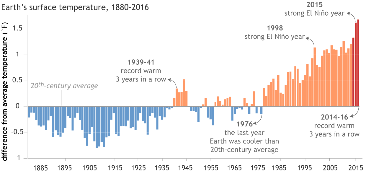
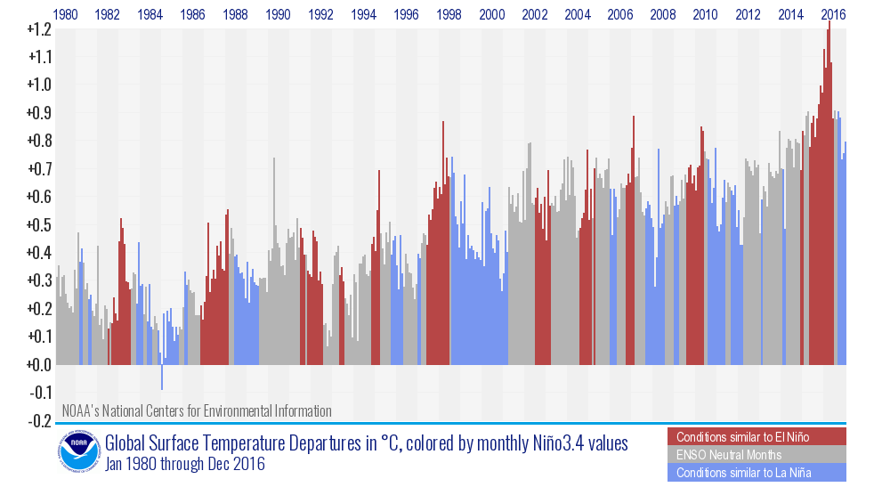

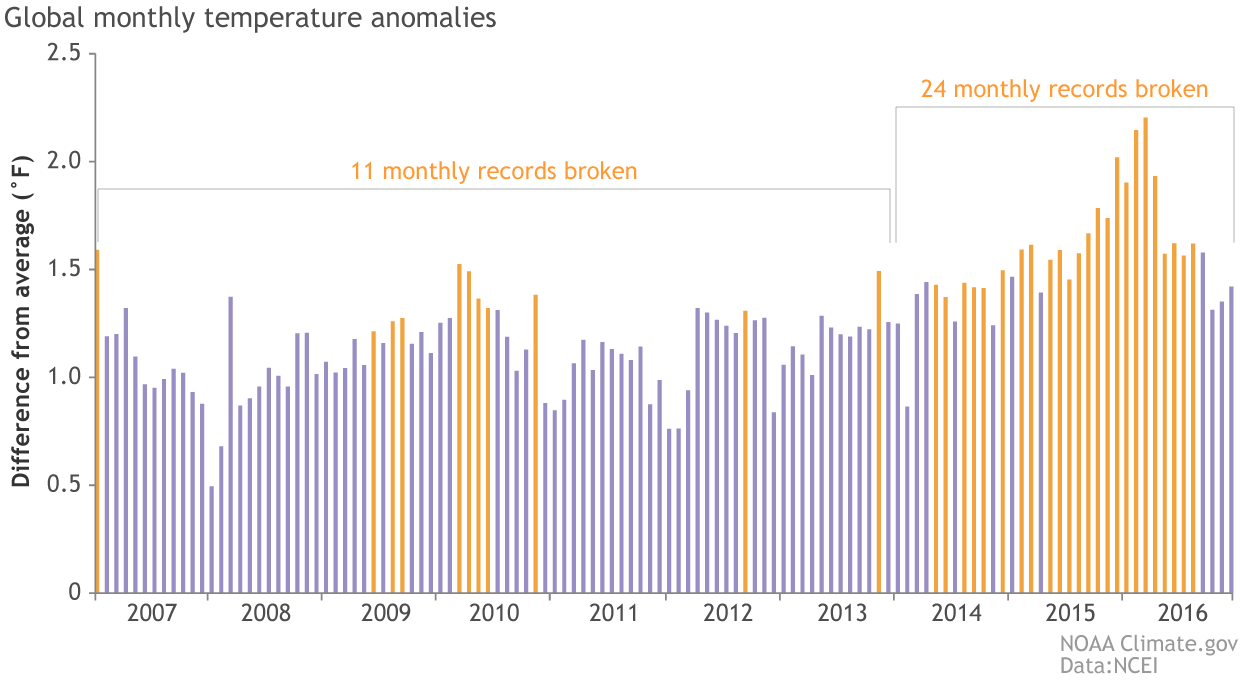
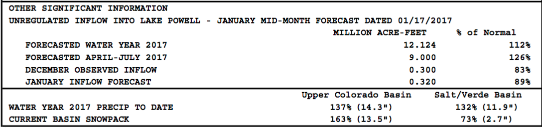


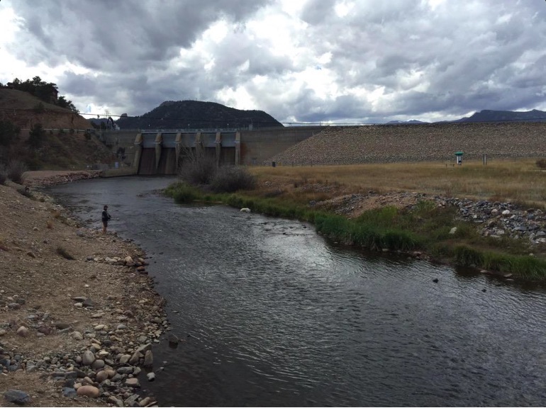
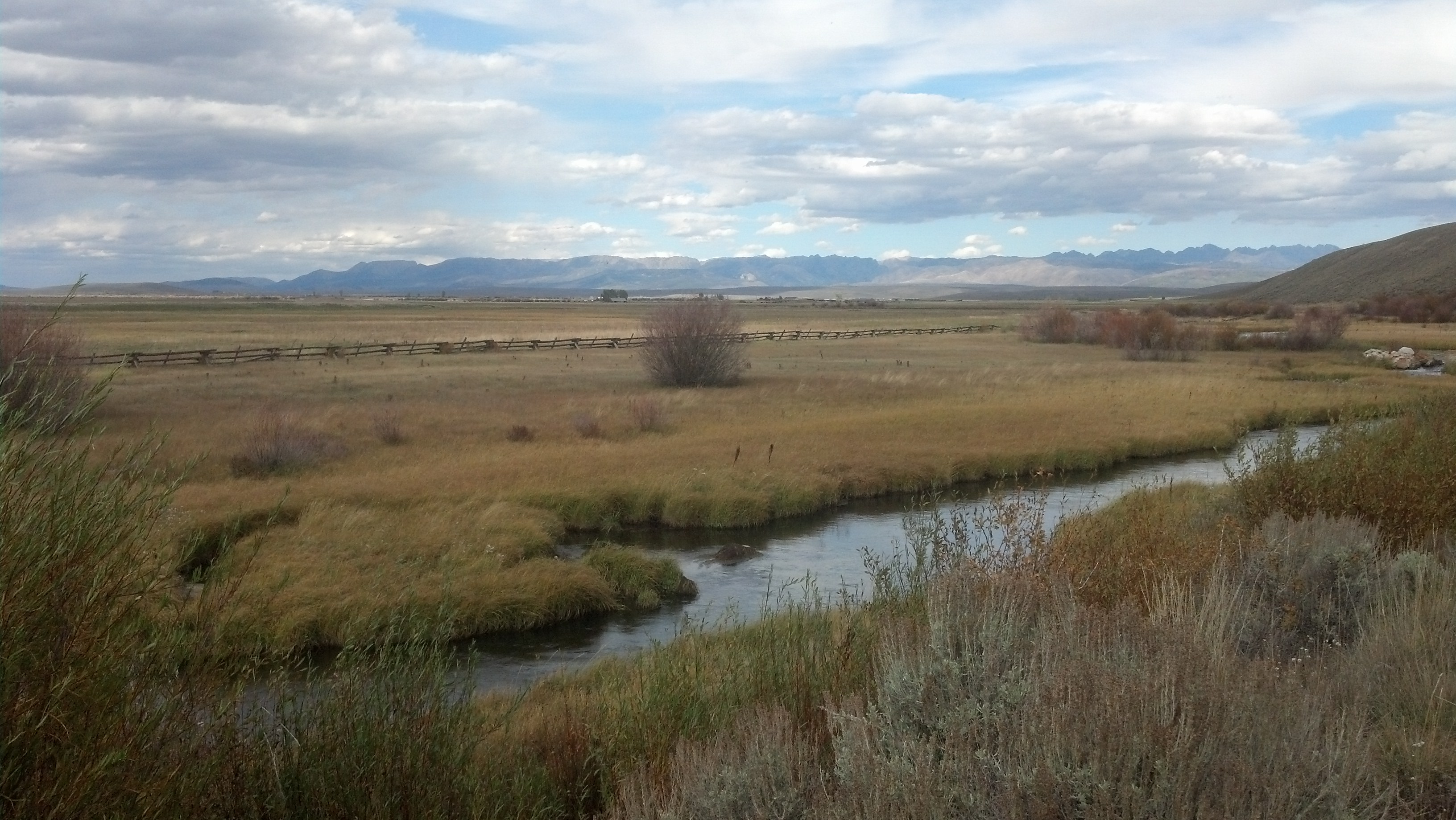


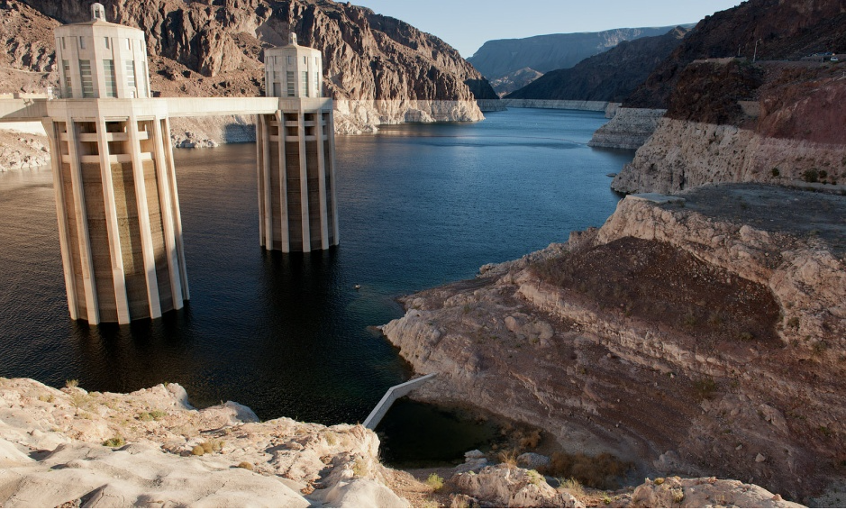


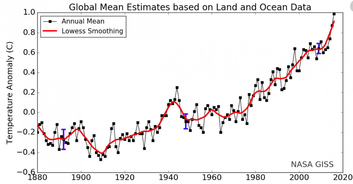

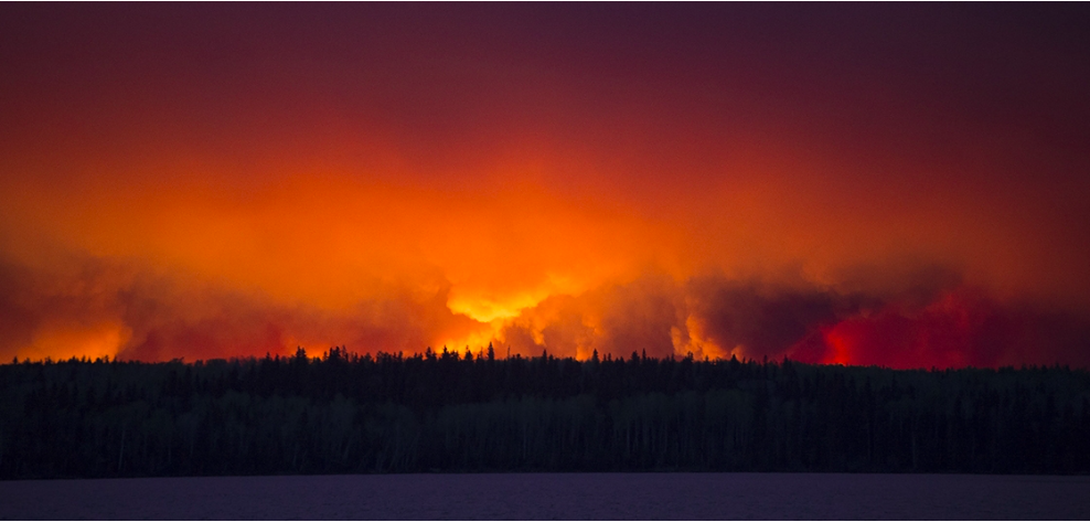


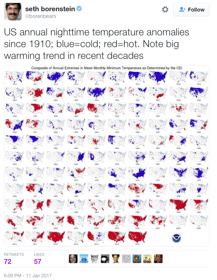


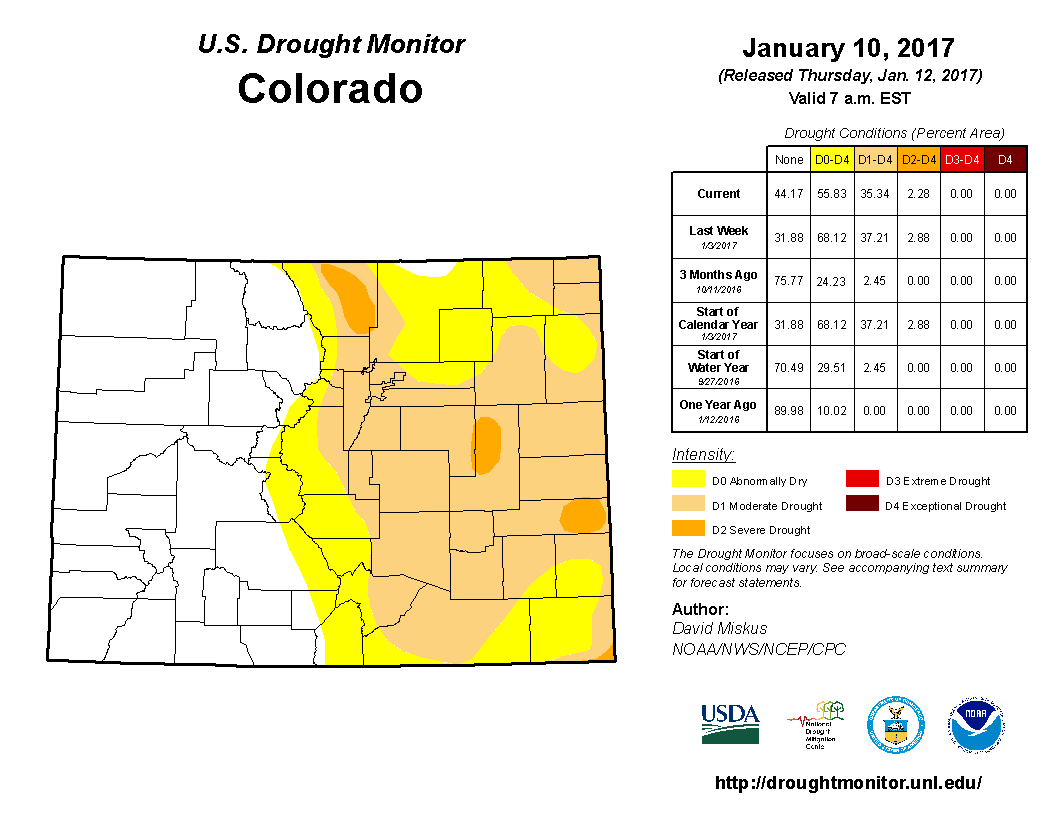
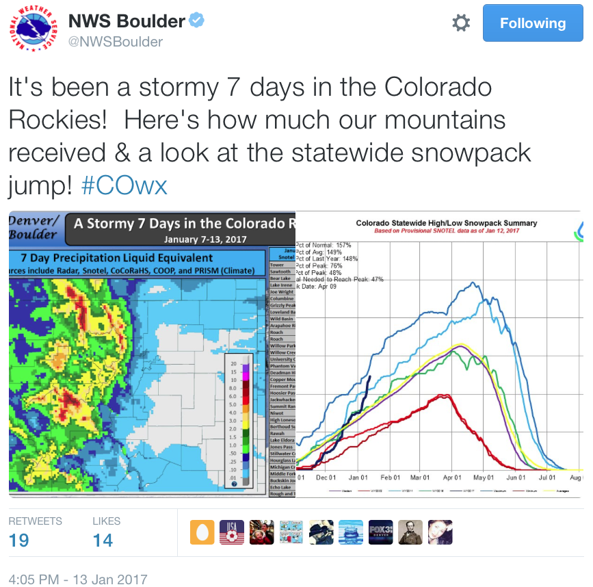


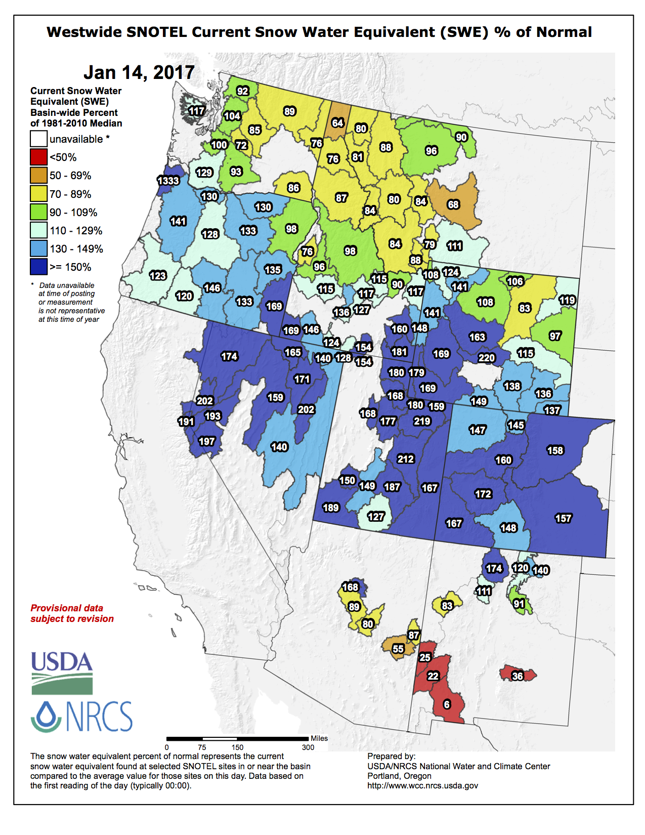

![This image was taken during the peak outflow from the Gold King Mine spill at 10:57 a.m. Aug. 5. The waste-rock dump can be seen eroding on the right. Federal investigators placed blame for the blowout squarely on engineering errors made by the Environmental Protection Agency’s-contracted company in a 132-page report released Thursday [October 22, 2015]](https://coyotegulch.blog/wp-content/uploads/2015/10/goldkingminespill1057am08052015viaepa.png)