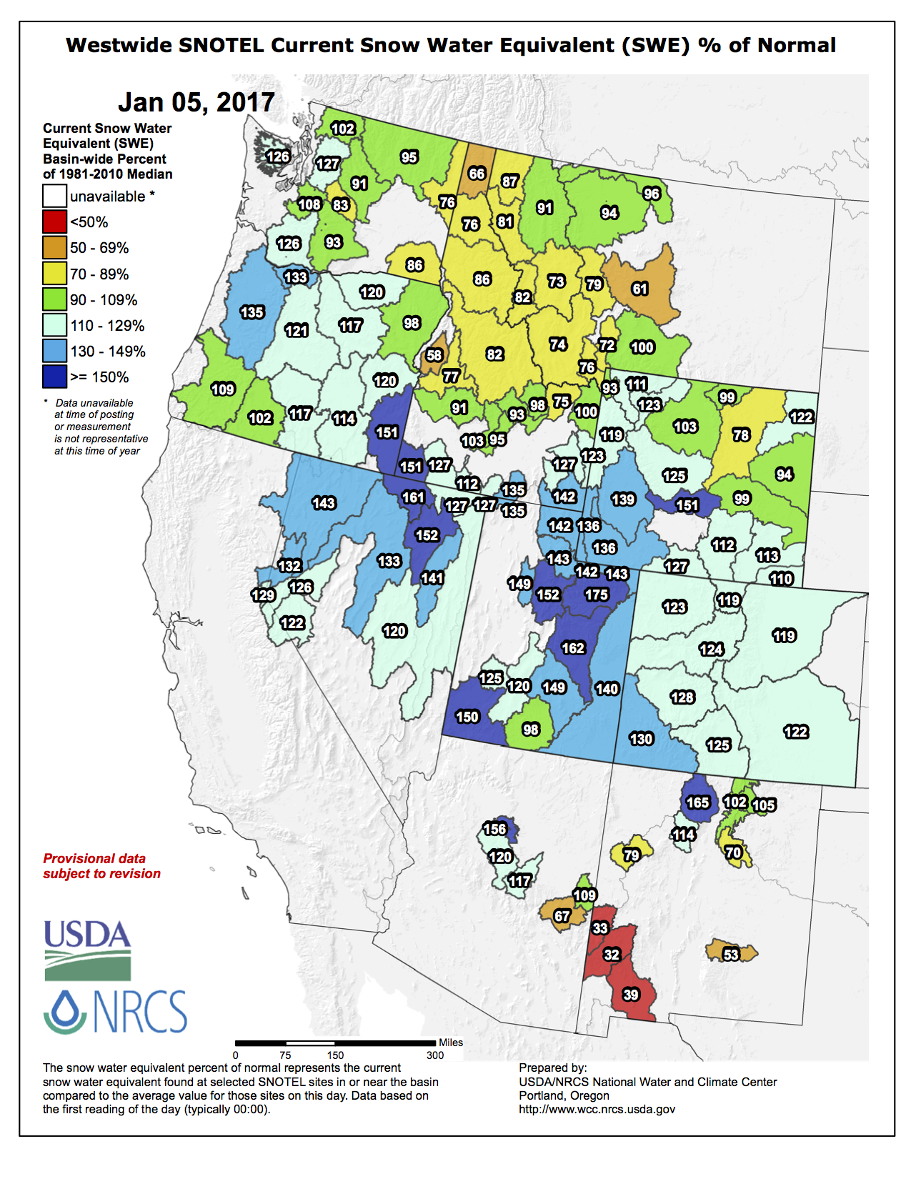
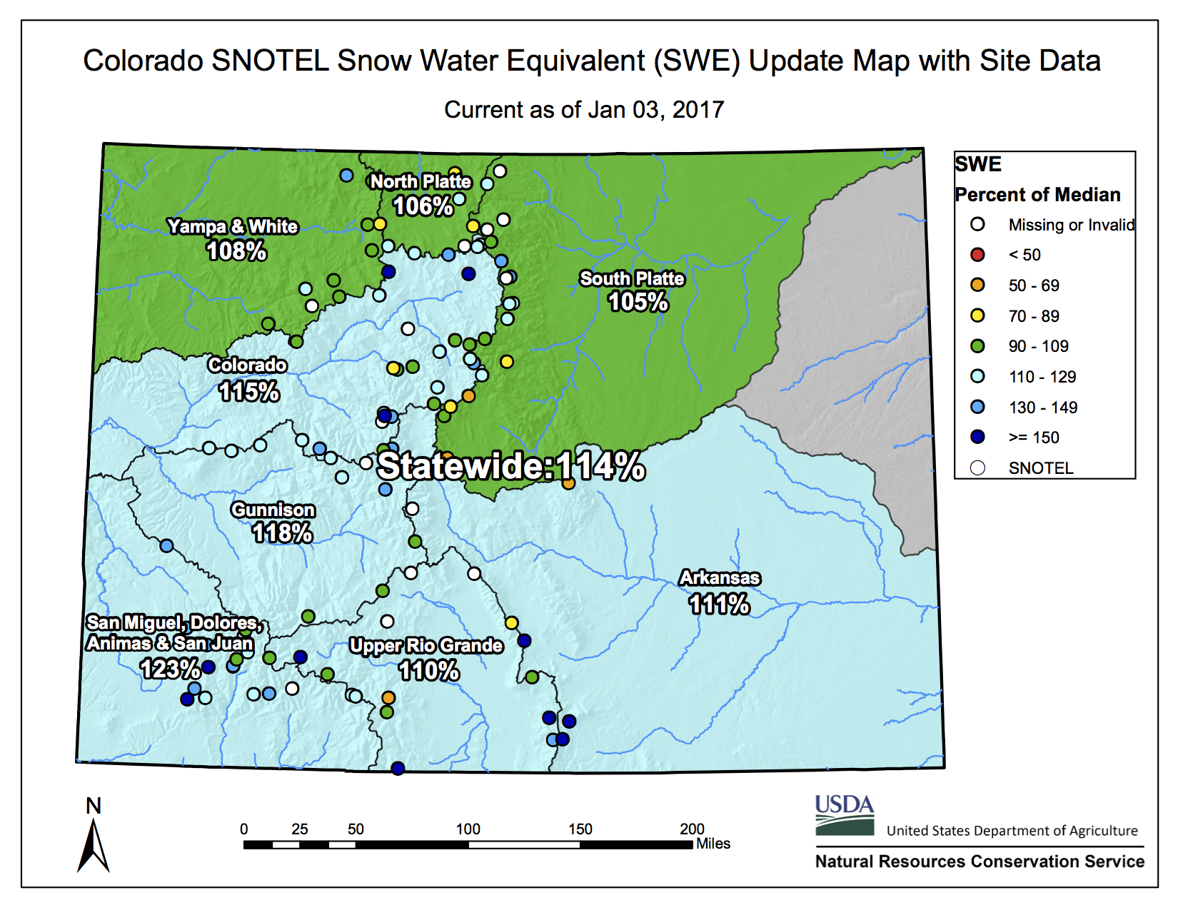
A dismal start for Colorado’s snowpack season is starting to feel like a distant memory after numerous storms that have boosted the statewide total to 150 percent of median as of Tuesday.
Snowpack accumulation, so crucial to agricultural and municipal water supplies, had been off to its worst start in more than 32 years in Colorado, at 6 percent of normal as of Nov. 17, the Natural Resources Conservation Service says.
“At that point prospects for reaching normal snowpack conditions by January 1st, 2017, were bleak, and chances of achieving normal snowpack by late April, when snowpack typically peaks, looked doubtful,” Brian Domonkos, NRCS snow survey supervisor in Colorado, said in a news release.
But a series of storms arrived starting on Nov. 17, resulting in a statewide gain of 7.4 inches of snow water equivalent through the end of the year, the fastest rate of gain over that time period since 1986.
The gains have continued since then thanks to storms like the ones that have wreaked havoc on western Colorado roadways in recent days. The state’s current snowpack of 150 percent of median is up from 114 percent at the month’s start. It rose 14 percentage points just between Monday and Tuesday.
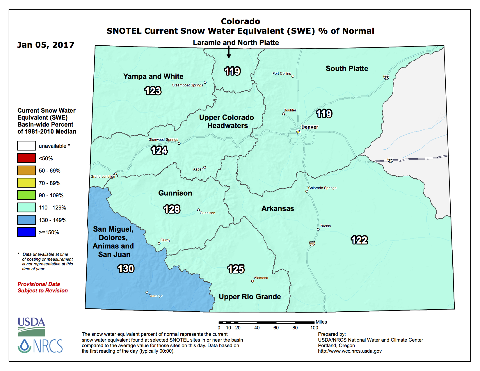
Snowpack in Colorado’s Upper Colorado River Basin was at 146 percent of median Tuesday, with the Gunnison River Basin at 158 percent of median. The state’s southwest corner — the San Miguel, Dolores, Animas and San Juan river basins — led the state, at 161 percent. And even the region with the lowest snowpack, the Yampa and White river basins, is at 133 percent.
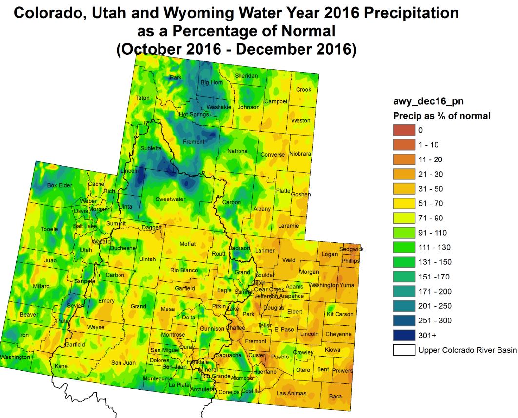
Precipitation in December in the Colorado River Basin was 181 percent of average, the NRCS says. Precipitation in the Gunnison Basin and far southwest Colorado were 170 and 171 percent of average for the month, respectively.
A high-pressure ridge had been blocking storms from reaching Colorado early in the snowpack season.
“We weren’t getting into the storm track so well,” said Aldis Strautins, a hydrologist for the National Weather Service in Grand Junction. “Now we’re into the storm track of late.”
Reservoir storage as of Jan. 1 was at 105 percent of average statewide, 106 percent of average in the Colorado Basin and 103 percent in the Gunnison Basin.
“Given current reservoir capacity, the collective storage in the majority of Colorado’s river basins will be well poised to provide adequate water supply if the above normal precipitation and snowpack trends experienced during December do not continue for the remainder of the water year,” the NRCS said in a start-of-the-year water supply outlook for Colorado.
Strautins said streamflows in Colorado this year are currently predicted to be normal or slightly below normal, but it’s early in the season to be trying to make such projections. Last fall’s soil moisture had been lower than normal going into winter.
Weather in the West currently remains under the influence of a weak La Niña pattern. La Niñas are associated with lower-than-normal surface ocean temperatures in the equatorial Pacific Ocean, and in Colorado tend to produce more snowfall in northern Colorado than southern Colorado.
“Those are kind of the trends. They don’t always work out that way,” Strautins said, pointing to state-leading snowfall so far this year in southern Colorado basins.
The recent string of storms have dumped so much heavy, wet snow that they’ve triggered avalanches — or fears of sliding snow — that have closed several high mountain passes in recent days.
Colorado Highway 65 over Grand Mesa reopened late Tuesday after being closed Monday for avalanche mitigation, according to Colorado Department of Transportation officials. Avalanche crews released two planned slides on the mesa Tuesday morning that were between 4 and 6 feet deep in some sections.
Planned avalanches were slated for several areas across the state as massive wet snowfalls created hazardous conditions in the backcountry as well as near major thoroughfares, evidenced by Tuesday morning’s natural avalanche that buried westbound lanes of Interstate 70 near Vail Pass with up to 15 feet of snow.
Ethan Greene, director of the Colorado Avalanche Information Center, said the snows throughout Colorado are wetter than normal.
“This is a really unusual event and it has to do with the amount of snow and the water content of that snow,” Greene said. “Some of the water contents are really impressive.”
CDOT Director of Highway Maintenance Kyle Lester said nearly every pass in the state system has had some natural slides from the weight of the wet snow.
“This is an extraordinary event,” Lester said. “We see these patches periodically throughout the year where every crew in the state is working avalanches during that storm cycle. The unique part about this is the moisture.”
While crews are working to clean up avalanches that crossed roads, as in Vail, Lester said new heavy snow in the backcountry just needs time to settle and stabilize.
Forecasters expect to see a transition to a more neutral phase between a La Niña and an El Niño early this year. El Niños are tied to warmer equatorial Pacific Ocean temperatures and generally favor southern Colorado over northern Colorado in terms of snowfall. Strautins said neutral phases make predicting long-term weather patterns more difficult, as reflected by the fact that the weather service’s Climate Prediction Center currently is forecasting an equal chance of above- or below-average precipitation in Colorado through this spring.
For now, however, “we’re in a good spot,” said Strautins, who had been among those closely watching the extremely dry start to the snowpack season.
Jim Pokrandt, spokesman for the Colorado River District, said he doesn’t think anyone predicted the state would be doing this well at this point in the year.
“Let’s keep putting the money in the bank while we’ve got it because it’s so hard to tell what’s going to happen in the balance of the year,” he said.
He pointed to last year, when the snow spigot pretty much turned off for about six weeks in January and February.
“That’s always lurking out there,” he said of the possibility of prolonged dry spells. “Just count our blessings for right now.”
While a wet winter would provide some short-term comfort, it’s going to take more than that for people such as Pokrandt to feel better about the overall water-supply picture in the Colorado River Basin. Water entities in the Southwest are worried about low water levels in Lake Powell and Lake Mead. In the Upper Colorado Basin, the focus is on measures to keep Powell’s water level from falling so low that water no longer can be released through hydroelectric facilities at Glen Canyon Dam. If that were to happen, it would not only prevent hydropower production, but would limit the ability to release water downstream and meet obligations by Upper Basin states to deliver water to Lower Basin states and Mexico.
“In the bigger picture we still have to treat Lake Powell levels as if it’s a near-term emergency and still do the contingency planning that’s necessary to preserve power-generation levels there,” he said.
The recent snow cycle has pushed Vail Mountain’s snowpack to 125 percent of normal, according to the Eagle River Water and Sanitation District.
Vail Mountain has received 29 inches in the last seven days. It reported 9 inches new on Tuesday morning.
Beaver Creek reported 11 inches new Tuesday, with 32 inches in the last seven days.
The snow season started slow, with warm temperatures and little precipitation. Vail delayed its opening in November. But consistent snow has fallen in December and January.
More snow is in the forecast for this week.
“Another wave of more intense snow should arrive on Wednesday, and this wave could drop 6-12 inches from Wednesday morning through Wednesday evening,” said Joel Gratz of opensnow.com
Westwide SNOTEL basin-filled map January 10, 2017 via the NRCS.
Author and journalist John Fleck says misinformation makes it difficult to discuss the best way to manage H20
“Whiskey is for drinking, water is for fighting,” runs an old saw about water in the West, sometimes attributed to Mark Twain.
Trouble is, there are two problems with the adage. It hasn’t been true in more than a century, and Twain never said it.
Busting myths about water was the subject of a talk given Tuesday morning at Arizona State University by author and journalist John Fleck, director of the water resources program at the University of New Mexico.
The lecture was titled “How Much Water Does Arizona Need?” It’s part of an ongoing conversation at ASU, where researchers from a range of disciplines study every facet of the faucet, from science and conservation to law and policy.
Fleck, who has covered water for about 30 years, published a book last year: “Water is for Fighting Over: and Other Myths about Water in the West.” He debunked common delusions and folk wisdom, like the saying “Water flows uphill toward money.”
While the aphorism refers to the massive 20th-century infrastructure projects like Hoover Dam and the Central Arizona Project canal, it also references the myth that rich communities take water from poor communities.
The opposite is true, Fleck said. He compared Las Vegas to California’s Imperial Valley.
“You can see these buildings around the Bellagio (fountain) and they represent about $6 billion” in revenue and income, he said.
By comparison, the total take from agriculture in the Imperial Valley is about $2 billion. “Yet, Imperial gets 10 times as much water as Las Vegas,” Fleck said. “Imperial is not going to give up their water, and Las Vegas has no way of taking it away.”
Locally, that example extends between the lettuce farmers of Yuma County and metro Phoenix in central Arizona. “In general, the notion that the rich communities will take water from poor communities is not true,” Fleck said.
Myths such as those make it difficult to establish collaborative relationships, Fleck said.
“Overcoming those myths becomes an important piece for water management to move forward in the Colorado River Basin,” he said.
So how much water does Arizona need? “I don’t know,” Fleck said. “Probably less than you think you need.”
A phenomenon rarely discussed in water circles, according to Fleck, is that per capita consumption is declining in Western cities. “Economists call this ‘decoupling,’” he said. “This is especially true in Arizona. … Users are just doing this. Attitudes are changing.”
Decoupling gives water managers the opportunity to create more collaborative decision making, Fleck said. Technology like low-flow faucets, showerheads and toilets now use half the water they did 25 years ago, and “adaptive capacity,” or human flexibility in learning to live with drought conditions, has quietly disrupted the apocalyptic nature of most water reporting.
Decoupling also puts to bed discussions about finding huge sources of water elsewhere, like building a pipeline from the Columbia River or towing icebergs down from Alaska.
“I think this is a conversation we’re going to be having for the rest of our lives,” Fleck said.
The lecture was sponsored by ASU’s Future H2O, the Kyl Center for Water Policy at the Morrison Institute, and the Decision Center for a Desert City.
The city of Colorado Springs, in response to a lawsuit that seeks court action against the city for discharging pollutants into tributaries of the Arkansas River, denies it is violating clean water laws.
The city’s denial is its first response in court to a lawsuit that claims discharges of pollutants into Fountain Creek and other tributaries violate the laws. The discharges are from Colorado Springs’ stormwater system.
“The City has complied with the law,” states the response filed Monday in U.S. District Court in Denver.
The lawsuit was filed Nov. 9 against Colorado Springs by the U.S. Environmental Protection Agency and the Colorado Department of Health and Environment.
The lawsuit seeks a court order requiring the city “to develop, implement, and enforce” its stormwater management program as specified in permits the government has issued in past years.
Colorado Springs asserted in Monday’s filing that it “has at all times been in compliance” with permits issued by the state agency to govern the discharges and the stormwater system.
The city contends it should not be subjected to court orders or monetary penalties that the environmental agencies want a judge to impose.
Colorado Springs also contends that allegations in the lawsuit misrepresent the facts of issues in dispute.
Click here to go to the website. From the website:
Global warming and climate change myths
Here is a summary of global warming and climate change myths, sorted by recent popularity vs what science says. Click the response for a more detailed response. You can also view them sorted by taxonomy, by popularity, in a print-friendly version, with short URLs or with fixed numbers you can use for permanent references.
Here’s the release from the US Bureau of Reclamation (Justyn Liff):
The Bureau of Reclamation has awarded a $3.7 million contract for modernization of the Silt Pumping Plant to Aslan Construction, from Berthoud, Colorado. The pumping plant is part of the Silt Project located near Rifle, Colorado.
The pumping plant was completed in 1967 and pumps water from the Colorado River to be stored in Rifle Gap Reservoir. Water from the reservoir is used for irrigation in the area. Modernization of the pumping plant includes: installing new pumps, refurbishing the pump motors, and replacing the electrical system.
Manufacturing of equipment and parts will begin during the winter of 2016. In the fall of 2017, after the irrigation season ends, work will begin to modernize the pumping plant. The project will be completed before the 2018 irrigation season.
The National Aeronautics and Space Administration is preparing to boldly go where many Coloradoans have gone before — into mountain snowpack. NASA is undertaking a five-year study of snow, called SnowEx, so that eventually new combinations of snow sensors can be placed on satellites.
Those sensors will show, on a global scale, how much water is in snow and how fast it is melting. That will help manage the world’s water supply, as well as better predict floods and droughts.
This study, which will be carried out at two Western Colorado sites, is fraught with what NASA scientists call “confounding factors,” most notably, trees. Past attempts to measure snow from satellites have failed to “see” through tree canopy.
On the Grand Mesa near Grand Junction, NASA chose a study site that is heavily forested and should be able to confound an array of high-tech airborne sensors. At the Center for Snow & Avalanche Studies in the San Juan mountains, NASA will study an extreme, high-altitude headwaters basin that has the benefit of decades of on-the-ground data collection.
In February, the NASA snow study will bring sensor-carrying aircraft to the sites, including a lumbering turbo-prop that will fly very low over the treetops for five days. Other study aircraft will be flying high and will be less noticeable.
NASA also plans to have 40 to 50 researchers on the ground to perform what the agency refers to as “ground truthing.” That means digging snow pits and measuring snow factors by hand to determine if the high-tech sensors on the aircraft are producing accurate data.
Got more questions about SnowEx? NASA has created a slide presentation, “Got Snow?” to explain the ins and outs, and ups and downs, of the project.
Here’s the release from the NRCS (Brian Domonkos):
The beginning of water year 2017, which started on October 1, 2016, experienced an extremely slow start. What little precipitation fell came in the form of rain, and warm autumn temperatures prevented snow from accumulating in all but the highest elevations. From the beginning of the water year through November 17th, 2016, statewide Colorado snowpack was off to the worst start in over 32 years at 6% of normal and year-to-date precipitation ranked in the bottom tenth percentile. “At that point prospects for reaching normal snowpack conditions by January 1st, 2017 were bleak and chances of achieving normal snowpack by late April, when snowpack typically peaks, looked doubtful” said Brian Domonkos, Snow Survey Supervisor for the Natural Resources Conservation s Service.
November 17th, 2016 was a real turning point for snowpack. Late summer quickly turned to winter and mountain snow began to accumulate quickly. According to automated Colorado Snow Telemetry (SNOTEL) data, from November 17th through January 1st, 2017 snowpack in the mountains grew at the fastest rate dating back to 1986, with an statewide gain of 7.4 inches of snow water equivalent (SWE). That increase is greater than 1997, 2008, and 2011 for that same period in their respective years.
Providing more current information Domonkos went on to say, “As of January 1st 2017 Colorado statewide snowpack is a healthy 114% of normal, riding in on the back of a December which saw 171% of normal precipitation.” Late November and December precipitation boosted statewide year-to-date precipitation from nearly 30% of normal on November 17th to 98% of normal on the first of this month. Combined reservoir storages in the state of Colorado rounds out 2016 at 105% of normal. The start of water year 2017 has been one of extremes, so far ending up on the favorable side.
At the time of this news release, streamflow forecasts are not available, but will be provided in detail in the January 1, 2017 Colorado Water Supply Outlook Report when it is made available.
For more detailed and the most up to date information about Colorado snowpack and supporting water supply related information, refer to the Colorado Snow Survey website at: http://www.nrcs.usda.gov/wps/portal/nrcs/main/co/snow/
Or contact Brian Domonkos, Colorado Snow Survey Supervisor at Brian.Domonkos@co.usda.gov or 720-544-2852.
Last Friday’s editorial (“Lots to unwind if Glen Canyon Dam shuttered too soon“) discussed the newly signed management plan for Glen Canyon Dam, but incorrectly attributed its 20-year focus to a possible end to federal management by 2036. Glen Canyon Dam is a crucial national resource and the federal government remains fully committed to its long-term successful management well into the future. This new plan enhances certainty and predictability for water and power users, while protecting downstream environmental and cultural resources. The plan’s 20-year focus simply provides a timeline for regularly adjusting dam operations as ongoing science and other factors inform future planning.
Several other assertions merit correction as well. There are no mounting bills for dredging or structural upkeep. Silt buildup hasn’t yet reached the dam and sediment deltas are more than 100 miles upstream in the reservoir. Estimates predict silt won’t fill behind the dam for 700 to 1,000 years. Sediment buildup poses no threat to the dam’s integrity–it is completely structurally sound.
Claims of lost water through seepage are also overstated. Some groups advocate decommissioning the dam based in part on outdated water loss studies. However, a recent assessment by the Center for Colorado River Studies at Utah State University found seepage rates are much lower than those groups claim and that rates are actually declining over time. Seepage water enters the ground water system and eventually returns to the reservoir or river channel.
Without both Lake Powell and Lake Mead, basin-wide drought impacts would have been even more severe. In fact, seven of the past 17 drought years saw less than 8 million acre feet (maf) of unregulated inflow into Lake Powell—that’s the amount that would flow to Lake Mead without Glen Canyon Dam. Four years saw less than 6 maf and 2002’s inflow was only 2.64 maf. However, during even the driest years, storage in Lake Powell allowed full water deliveries with average annual releases of 8.71 maf throughout the drought.
Examining total water storage and use further highlights Lake Powell’s continued importance. Storage capacity at Lakes Mead and Powell is finite—Lake Mead’s maximum capacity is 28.9 maf and Lake Powell’s is 26.2 maf, for a total combined capacity of 55.1 maf. Both reservoirs were at or near full when the drought began in 2000. By the end of water year 2016, regular water deliveries had depleted combined reservoir storage by 30.7 maf—more than either Lake Mead or Lake Powell could support on its own. Without Lake Powell’s storage, those obligated water deliveries would have completely drained Lake Mead before 2016.
Far from being an underachiever, Glen Canyon Dam is doing precisely what is was intended to do — storing water in wet years to ensure predictable, full deliveries across the basin every year. Populations in Arizona and the west continue to grow, as do the challenges and complexities of efficiently managing limited water resources. Glen Canyon Dam has been integral to meeting those challenges for more than 50 years and will continue its role for many decades to come.
Glen Canyon Dam photo credit Greg Hobbs.
Glen Canyon Dam releases. Photo via Twitter and Reclamation
Glen Canyon Dam
Glen Canyon High Flow Experiment November 2013 via Jonathan Thompson
A high desert thunderstorm lights up the sky behind Glen Canyon Dam — Photo USBR
Glen Canyon Dam June 2013 — Photo / Brad Udall
November 2012 High Flow Experiment via Protect the Flows
Glen Canyon Dam discharge via Tom Smart
Glen Canyon Dam back in the day when the reservoir was nearly full
Westwide SNOTEL basin-filled map January 9, 2017 via the NRCS.
Click here to read the latest assessment. Here’s an excerpt:
Highlights:
Snowpack conditions have completely turned around after a grim start. A major storm kicked off the new year, and as of January 9 nearly all basins across the region have above-median SWE, with most basins at 120-170% of median. The snowpack across Colorado, Utah, and Wyoming for the date appears to be the 3rd-highest in the past 25 years, after 1997 and 2011.
The January 1 NRCS spring-summer runoff forecasts call for near-average to much-above-average runoff across the region, with the highest runoff expected in Utah and western Wyoming. Note that these forecasts do not incorporate the most recent snowfall.
Nearly all of the region was wetter than normal in December, with many areas seeing over 200% of normal precipitation. Statewide, Wyoming was in the 96th percentile for precipitation, Colorado was in the 90th percentile, while Utah was in the 88th percentile.
There was a strong north-south gradient in temperature anomalies in December, with southern and eastern Utah and western Colorado warmer than normal, while much of Wyoming was 6-12°F below normal for the month.
Since early December there has been improvement in drought conditions, mainly from D0 to drought-free, in western Colorado, eastern Utah, and northern Wyoming. The proportion of the region in D1 or D2 conditions has held steady, with 37% of Colorado, 13% of Utah, and 16% of Wyoming.
Weak La Niña conditions are persisting, barely, in the tropical Pacific. The ENSO forecast models now more strongly favor a return to ENSO-neutral conditions by late winter/early spring. NOAA CPC seasonal forecasts show a La Niña-esque wet tilt in the odds for Wyoming over the next 3-4 months.
“My priorities are, obviously, water storage, agriculture, and education,” Sonnenberg said during a lengthy interview Monday with the Journal-Advocate.
On water, Sonnenberg already has declared that any bill coming across his committee’s desk that doesn’t include storage will be DOA.
“Don’t get me wrong, I’m all for conserving water, but we have to have someplace to store all of that water we’re conserving,” he said. “But for some reason, water storage has become a partisan issue. People seem to think that conservatives, ag, Republicans — are all against conservation and we’re not. Agriculture has led the charge on water conservation.”
He recounted the evolution of irrigation from flood to center pivot to drop-head sprinklers to drip irrigation.
Barker Meadows Dam Construction
“But water storage has to be a major part of every conversation we have about water,” he said.
Although he’s one of the few actual agricultural producers in the Legislature, Sonnenberg won’t spend much time advancing bills about growing food and fiber in Colorado. What he will do, however, is advocate for ways to make farming more profitable. After all, farm profitability is critical, Sonnenberg said, if America is going to entice young people to take over the responsibility of feeding the world. The senator said that, at 58, he’s still considered a “young farmer,” and that something needs to be done to lower the median age of farmers in the United States. That median age now is 59.
“But kids can’t come back to the farm if they can’t survive,” he said, and then proceeded to tick off the capital investments needed in equipment, land, and infrastructure. It was a bleak picture.
“What I can do is be an advocate,” he said. “My role as chair (of the Ag Committee) and as (President) Pro Tem (of the Senate) is to be an advocate to my federal partners. I have a good relationship with those people.”
[…]
Sonnenberg has some ideas about what his “federal partners” can do to help make farming more profitable, especially for younger farmers.
“What the government can do, without just outright giveaways, is help farmers manage the risk. They can do that by contributing a percentage of the premiums for crop insurance,” he said. “My biggest fear every year is hail, but hail insurance costs me $18 to $20 an acre,” he said. “You put that on top of all the other inputs — seed, fertilizer, fuel, pesticides — it’s just not profitable at anything less than $4 or $5 a bushel for wheat.”
[…]
The first-term senator also will be keeping an eye on the conservation easement debacle, which he said he thinks will cost the state more than it will ever recover from tax credits that have been retroactively disallowed. He knows Rep. Becker will again introduce a bill aimed at giving landowners relief while they haggle with the state over paying back those tax credits, and is ready to do what he can to promote it in the Senate.
He also intends to advocate on behalf of rural communities having to rebuild their sewer and water systems because of higher standards being imposed by the federal Environmental Protection Agency and the Colorado Department of Public Health and Environment.
“What they’re doing to those small communities is a travesty,” he said. “You have a town with only, maybe, 100 (water) taps and they’re being held to a water quality standard that can’t be met economically. Is it cost effective to make sure every community has distilled water to drink? I don’t think so.”
FromThe Grand Junction Daily Sentinel (Charles Ashby):
Southwest Colorado got two new lawmakers over the weekend — one new lawmaker and a familiar one.
That happened when the central committee for Senate District 6 chose Rep. Don Coram, R-Montrose, to replace Sen. Ellen Roberts of Durango, who resigned her seat at the end of last year.
In his place, the central committee for his seat in House District 58 chose Marc Catlin to replace him.
Catlin, a graduate of Mesa State College, is the water rights development coordinator for Montrose County who also sits on the board of the Colorado River Water Conservation District.
Catlin also is a former manager of the Uncompahgre Valley Water Users Association, and hosts a weekly talk show on 580 AM radio, where he mainly focuses on water issues on the Western Slope.
Coram, who was first elected to the Colorado Legislature in 2011, was just re-elected to a third term in the Colorado House in November.
He’s already been assigned to the Senate agriculture and judiciary committees.
Both men will be sworn into office alongside their colleagues when the 2017 session of the Legislature convenes on Wednesday.
Say hello to ColoradoPolitics.com a new service from The Colorado Springs Gazette.
From the City of Greeley via the The Greeley Tribune:
In 2016, the city of Greeley worked on several drainage improvement projects in the Sunrise Neighborhood.
A study was done to define and prioritize the drainage solutions for the neighborhood, and it found many of the existing storm sewers in the neighborhood were over 100-years-old, narrow, damaged or failing. Through a series of projects, the city has replaced many of the damaged pipes to improve drainage and reduce flood potential to properties and public areas, according to a news release.
Stormwater staff held public meetings, and visited ABC East Child Development Center in the neighborhood to teach children what was happening with the construction in their neighborhood and had all of the kids decorate and sign some of the stormwater pipes that were installed underground.
In 2017, Stormwater work will resume in the area along 9th Street and 6th Avenue to further improve the drainage system in the neighborhood.
Go to http://OperationRainDrain.com to keep informed about this and other projects to improve drainage and reduce flooding issues.
Scott Hummer, general manager of North Poudre Irrigation Company, talks about how his agency worked with Fort Collins Natural Areas and Colorado Parks and Wildlife to include a fish passage when the irrigation company replaced a diversion structure on the Poudre River that was destroyed by the 2013 floods. Work was completed [in February 2016]. (Pamela Johnson / Loveland Reporter-Herald)
Here’s the release from Colorado State University (Jim Beers):
The Cache la Poudre River, which flows from the mountains through Fort Collins, Timnath and Windsor to the plains east of Greeley, is at the heart of countless activities: from irrigating crops and lawns to providing drinking water for more than 365,000 people and hosting numerous recreational activities.
Those with connections to and concerns for the Poudre River will gather on Friday, Feb. 3 for the fourth annual Poudre River Forum. After its first three years at Larimer County Fairgrounds, the forum is moving down the river to Greeley as a reminder that the Poudre River is important to all who benefit from it — from its headwaters to its confluence with the South Platte. This year’s forum — the theme is “As the Poudre Flows — Forest to Plains” — will be held from 8:30 a.m.-4:30 p.m. at the Island Grove Events Center, 501 N. 14th Ave., Greeley. Pre-registration is required for all participants.
Understanding the river, each other
Sponsored by the Poudre Runs Through It Study/Action Work Group, the forum serves as a community-wide gathering of people from agricultural, municipal, business, recreational and environmental backgrounds to learn about and discuss issues related to the Poudre River.
“The Poudre River Forum brings together those who use the river for agricultural and urban diversions and those who work to improve its ecological health. In the past those groups have not necessarily seen eye to eye,” said MaryLou Smith, PRTI facilitator. “Increasingly our participants are open to the idea that it takes collective vision and action to make the Poudre the world’s best example of a healthy, working river.”
Once again, this year’s event will be facilitated by the Colorado Water Institute at Colorado State University. “The Forum is a great opportunity for the communities connected by the Poudre River to come together to better understand the entire watershed, and each other,” said Reagan Waskom, director of CWI.
Forests and water quality/quantity
Laurie Huckaby with the U.S. Forest Service, will present “The last 1,000 years in the Poudre according to the trees,” to kick off the topic of how important the upper watershed is to water quantity and quality.
“Water quality and forests are inextricably linked,” said Joe Duda of the Colorado State Forest Service, who will join Huckaby as one of the presenters. “Forest conditions and insects, disease and fire all can have profound impacts on water flow and quality. Only healthy, resilient forests can continuously supply clean water.”
Global lessons for local success
“Finding the Balance: Managing Water for People and Nature” is the message of keynote speaker Brian Richter. Richter has been a global leader in water science and conservation for more than 25 years, and currently serves as chief scientist for the Global Water Program of The Nature Conservancy in Washington D.C. Richter’s ideas about the importance of recognizing the balance of working river/healthy river are the basis for which PRTI was initially formed. He has consulted on more than 120 water projects worldwide, and has served as a water advisor to some of the world’s largest corporations, investment banks, the United Nations, and has testified before Congress on multiple occasions. Richter co-authored,with Sandra Postel, the 2003 book Rivers for Life: Managing Water for People and Nature and in 2014 wrote Chasing Water: A Guide for Moving from Scarcity to Sustainability.
Change affects all sectors
An afternoon panel session will probe the impacts of change — positive and negative — along the Poudre River and how they have been similarly and differently addressed by agriculture, urban, and environmental sectors. They will discuss what anticipated future changes might these three sectors see as opportunities or incentives for mutually beneficial collaboration that could result in a healthier, working river?
“It has been said that the only thing that is constant is change,” said John Bartholow, retired ecologist from U.S. Geological Survey, and panel coordinator/moderator. “The question is, can we learn to adapt to those changes sure to come on the Poudre in ways that benefit agriculture, municipalities, and the environment?”
The panel will include Eric Reckentine, deputy director, City of Greeley Water and Sewer; John Sanderson, director of science, Nature Conservancy of Colorado; and Dale Trowbridge, general manager, New Cache la Poudre Irrigating Company.
Videos, displays and music too
The day-long forum also includes “River Snapshots” highlighting more than 15 projects undertaken by a variety of groups on the Poudre last year; “My How the Poudre Has Changed,” featuring historical 1970’s footage of the Poudre; updates from both the cities of Greeley and Fort Collins on current water programs; and over two dozen river-focused displays from community organizations and agencies. The day concludes with a social hour including food, beer and other beverages, and river-themed door prizes.
Registration is $50 and includes lunch. Scholarships for students and reduced rates are available. The deadline to register is Friday, Jan. 27 at http://prti.colostate.edu/forum_2017.shtml.
For more information, contact event coordinator Gailmarie Kimmel at PoudreRiverForum@gmail.com or 970-692-1443.
Big snow is expected to buffet Colorado mountains Monday through Tuesday morning – up to 28 inches according to the National Weather Service – serenaded with wind gusts reaching 70 miles per hour on high ridges.
It’s the latest of several recent snowstorms that have raised snowpack to 125 percent of average in the South Platte River Basin, the main water source for metro Denver and northeastern Colorado food production.
But snow in Denver will keep melting. Weather Service meteorologists say metro area temperatures may reach 60 degrees Monday and that residents should expect highs around 50 degrees through midweek. Winds still will be blowing down through the foothills at speeds of 35 mph and greater.
For the mountains, storm warnings were issued Sunday for Monday through Tuesday morning. The heaviest snow will fall west of the Continental Divide, with some spreading to the east, meteorologist Kyle Fredin said.
“We’ve had three or four of these and this is another good one. It’s a little moister, more in the way of snowfall. But for driving – dangerous conditions in some instances,” Fredin said.
Snow’s been pelting the western states from Montana south, and some of the water-stressed West Coast regions may benefit.
“It is coming straight off the Pacific Ocean,” Fredin said, “and in California it is starting to fill reservoirs.”
Westwide SNOTEL basin-filled map January 8, 2017 via the NRCS.
Here’s an appeal to the incoming administration and Congress to open their eyes to science and economics and pay attention to the need to solve supply problems in the Colorado River Basin from Anne Castle and Eric Kuhn writing in The Denver Post:
[The President-elect]…the new leaders in his administration, and the 115th Congress each have important roles to play in helping Colorado and the six other states of the Colorado River basin forge a path toward water security. The independent Colorado River Future Project recently spoke with water leaders across the basin to collect specific recommendations to the incoming administration concerning the issues that must be addressed immediately.
The Colorado River system is Colorado’s foundation and future. It has been estimated that the river helps to contribute $189 billion to the Colorado economy each year and supports more than two million jobs. Each and every sector of the economy is tied to the river, from real estate to health care to our growing information technology industry.
The river system is facing challenges never seen before. Years of drought and imbalance between supply and demand have taken their toll. We are on the brink of the first-ever water shortage declaration, which could mean significant reductions in deliveries to Arizona, Nevada, and Mexico as soon as 2018, as well as increased pressure on Lake Powell supplies in the very near future. In order to avoid crippling impacts to our shared regional economy, Colorado River water users across the West must come to grips with the limitations of the river’s supplies. This will require creative leadership, compromise, and new funding.
The lower basin states of Arizona, California, and Nevada must come to closure on a drought contingency plan to stabilize water levels at Lake Mead, and the United States must finalize an agreement with our neighbors in Mexico to provide for sharing of both shortages and surpluses on the river and encourage water conservation.
The upper basin states, including Colorado, must put in place water saving mechanisms to reduce the risk of significant shortages in the future. An essential component is expanded Federal funding to bring supply and demand into balance in the Colorado River system through voluntary and compensated conservation measures that protect senior water rights.
These are not partisan issues. Conserving our limited Western water supplies is a priority for citizens and elected officials and a vital underpinning to support economic stability for agriculture, businesses, and citizens. Water leaders stand ready to work together with [the President-elect]…the new leaders in his administration and the new Congress to craft viable solutions and sustain this jewel and economic engine of the Southwest.
R. Eric Kuhn is the general manager for the Colorado River Water Conservation District. Anne Castle directs the Colorado River Future Project.
Officials in charge of the Windy Gap Firming Project are checking to make sure that a Dec. 7 Colorado Supreme Court decision won’t adversely affect the $387.36 million transmountain water diversion project that will benefit the Front Range…
…in December, the Colorado Supreme Court sided with western slope interests against Aurora in case that had to deal with pumping western slope water across the continental divide and storing it on the eastern slope. Aurora had a one-half interest in the Busk-Ivanhoe Diversion Project in western Colorado.
Jim Pokrandt, spokesman for the Colorado River District, said the case relied on storage rights for the water.
“The big crux of the Aurora case is that they didn’t have the storage rights for the transmountain water that they took,” Pokrandt said. “So I’m sure what a lot of folks are doing is looking at their water decrees and seeing if they actually have decreed storage rights for transmountain water. That’s the question for the Windy Gap Firming Project.”
Pokrandt said that in the Colorado River District’s view, the court made the right decision.
“Our position is that water law is water law and under ordinary water law, you need a water right to store water. And Aurora argued that transmountain water didn’t need an exact water right to store it,” Pokrandt said. “But, no you do need that because water law is water law and there’s nothing special about transmountain water.”
The municipal subdistrict of the Northern Colorado Water Conservancy District is leading the Windy Gap Firming Project.
Eric Wilkinson, general manager of the municipal subdistrict, said they have staff researching to make sure the Aurora decision is unique to the case and to verify that the Windy Gap Firming Project is on legally stable ground moving forward.
“The Busk-Ivanhoe decision has a very significant application statewide … what the (Colorado) Supreme Court decision did is apply, in essence, 2016 water rights administration and laws to a decree that is dated 1928,” Wilkinson said.
Wilkinson added that staff are verifying that they have the water decrees to store Windy Gap water on the within the basin of use, which would be on the western slope.
Northern Spokesman Brian Werner said they are fairly certain the Colorado Supreme Court decision shouldn’t have major impacts on the Windy Gap Firming Project, which has been in the works since 2004.
“I want to emphasize that intent to store, we’ve had that all along with the Windy Gap Firming Project,” Werner said. “So if you’re asking what the impact (of the decision) is on the Windy Gap Firming Project, I can tell you there shouldn’t be any.”
Wilkinson added that with Colorado water law, nothing is certain forever.
“That’s the intent of our research to get to that point (of certainty),” Wilkinson said.
“But in Colorado water law and some of the interpretations that come out, there is not such a thing as absolute certainty. This Busk-Ivanhoe decision introduced some change in thought that didn’t exist before so say ‘here’s how it will be always and forever in absolute certainty’ is probably unreasonable, but we’re trying to get to a reasonable amount of certainty.”
Colorado transmountain diversions via the State Engineer’s office
Coyote Gulch contributor Brent Gardner-Smith took a deep dive into the decision to extract a summary of the water court process for a change of use. Below is his email:
John,
You might appreciate this. In the midst of the Busk opinion is summary of the factors that go into changing a water right. I’ve stripped it of the legal references, but otherwise, it’s the court’s words. Thought you might appreciate it. Not sure what else to do with it yet.
BGS
Under Colorado’s doctrine of prior appropriation, a water right is a usufructuary right that affords its owner the right to use and enjoy a portion of the waters of the state.
One does not “own” water, but owns the right to use water within the limitations of this doctrine.
The touchstone of Colorado’s prior appropriation doctrine is beneficial use. That is, an appropriator perfects a right to use water by applying a specified quantity of unappropriated water to a beneficial use.
“Beneficial use” is “that amount of water that is reasonable and appropriate under reasonably efficient practices to accomplish without waste the purpose for which the appropriation is lawfully made.”
Colorado water law has long recognized the right of water users to make changes to the terms of their decrees—including changes to the type, place, or time of beneficial use; changes to the points of diversion; changes to storage; and changes from direct flow to storage and subsequent application and vice versa.
Permanent changes to a water right must be decreed through the adjudication process established by the legislature … and … parties wishing to change the use of a water right must obtain a water court decree allowing the change in use.
It is inherent in the notion of a ‘change’ of water right that the right itself can only be changed and not enlarged.
This is a basic predicate of water law dating to the nineteenth century; a change application merely continues the rights decreed in the original appropriation in a new form and may not expand the amount of water actually used under the original decree.
In other words, “the right to change a water right is limited to that amount of water actually used beneficially pursuant to the decree at the appropriator’s place of use.”
Thus, in order to determine that a requested change of a water right is merely a change, and will not amount to an enlargement of the original appropriation, the court must quantify the historic use of the right to some degree of precision.
Quantification of the amount of water beneficially consumed pursuant to the decree guards against rewarding wasteful practices or recognizing water claims that are not justified by the nature or extent of the appropriator’s actual need.
An absolute decree confirms that a right of appropriation has vested; the decree entitles the appropriator to use that right through its decreed point of diversion in a specified amount, usually expressed as a flow rate (for a diversion right) or in acre-feet of water (for a storage right).
The term “historic use” refers to the “historic consumptive use” or “historic beneficial consumptive use,” attributable to the appropriation of that quantity of water historically consumed by applying the water to its decreed beneficial use.
However, because “the period and pattern of use are not known with certainty at the time a water right is adjudicated,” the decreed flow rate at the decreed point of diversion is not the same as the matured measure of the water right.
Rather, over an extended period of time, “a pattern of historic diversions and use under the decreed right for its decreed use at its place of use” will become the true measure of the mature water right for change purposes, typically quantified in acre-feet of water consumed.
Crucially, proper analysis of the historic consumptive use of a water right measures the amount of water both actually and lawfully used in accordance with the decree.
Because beneficial use defines the genesis and maturation of every appropriative water right in this state, every decree includes an implied limitation that diversions are limited to those sufficient for the purposes for which the appropriation was made.
Importantly, the actual historic diversion for beneficial use may be less than the decreed rate because, for example, “that amount has simply not been historically needed or applied for the decreed purpose.”
Indeed, we have often observed that when an appropriator exercises the right to change a decreed water right, he runs the real risk that the right will be requantified at an amount less than his original decree, based on the actual historic consumptive use of the right.
In short, an initial change application reopens the original decree for determination of the true measure of the appropriative right’s consumptive use draw on the river system.
In sum, “the fundamental purpose of a change proceeding is to ensure that the true right — that which has ripened by beneficial use over time — is the one that will prevail in its changed form.”
The decision is actually a page-turner for water wonks.
This graphic shows the transmountain diversions in Colorado.
A map of the Busk-Ivanhoe system, with Ivanhoe Reservoir on the left side of the map and Turquoise Reservoir on the right.
The Flatirons from Wheat Ridge photo via Wheat Ridge 2020
From email from the Colorado Water Conservation Board (Ben Wade):
The next Water Availability Task Force meeting will be held on Thursday, January 19, 2017 from 9:30-11:30am at the Colorado Parks & Wildlife Headquarters, 6060 Broadway, Denver in the Red Fox Room.
This image was taken during the peak outflow from the Gold King Mine spill at 10:57 a.m. Aug. 5. The waste-rock dump can be seen eroding on the right. Federal investigators placed blame for the blowout squarely on engineering errors made by the Environmental Protection Agency’s-contracted company.
Here’s the release from the Environmental Protection Agency (Christie St. Clair):
Today, the U.S. Environmental Protection Agency (EPA) posted the final fate and transport report for the Gold King Mine (GKM) release. The report focuses on understanding pre-existing river conditions, the movement of metals related to the GKM release through the river system, and the effects of the GKM release on water quality. The research supports EPA’s earlier statements that water quality in the affected river system returned to the levels that existed prior to the GKM release and contamination of metals from the release have moved through the river system to Lake Powell.
“This report is a comprehensive analysis of the effects on water quality from the Gold King Mine release,” said Dr. Thomas A. Burke, EPA’s Science Advisor and Deputy Assistant Administrator of EPA’s Office of Research and Development. “While data indicate that water quality has returned to pre-event conditions, EPA is committed to continue our work with States and Tribes in the river system affected by the Gold King Mine release to ensure the protection of public health and the environment.”
The area affected by the Gold King Mine release consists of complex river systems influenced by decades of historic acid mine drainage. The report shows the total amount of metals, dominated by iron and aluminum, entering the Animas River following the release — which lasted about nine hours on August 5, 2015 –was comparable to four to seven days of ongoing GKM acid mine drainage or the average amount of metals carried by the river in one to two days of high spring runoff. However, the concentrations of some metals in the GKM plume were higher than historical mine drainage. As the yellow plume of metal-laden water traveled downstream after the release, the metal concentrations within the plume decreased as they were diluted by river water and as some of the metals settled to the river bed.
There were no reported fish kills in the affected rivers, and post-release surveys by multiple organizations have found that other aquatic life does not appear to have suffered harmful short-term effects from the GKM plume. The concentrations of metals in well-water samples collected after the plume passed did not exceed federal drinking water standards. No public water system using Lake Powell as a source of drinking water has reported an exceedance of metals standards since the release.
Some metals from the GKM release contributed to exceedances of state and tribal water quality criteria at various times for nine months after the release in some locations. Metals from the GKM release may have contributed to some water quality criteria exceedances during the spring 2016 snow melt. Other exceedances may reflect longstanding contributions of metals from historic mining activities in the region and natural levels of metals in soils and rocks in the area. EPA will continue to work with states and tribes to interpret and respond to these findings.
Results from this analysis will inform future federal, state and tribal decisions on water and sediment monitoring. EPA will continue to work with states and tribes to ensure the protection of public health and the environment in the river system affected by the Gold King Mine release.
Read the final report, “Analysis of the Transport and Fate of Metals Released From the Gold King Mine in the Animas and San Juan Rivers”: https://cfpub.epa.gov/si/si_public_file_download.cfm?p_download_id=530074
The 2015 Gold King Mine spill deposited nearly 540 tons of metals over a 9-hour period into Cement Creek, which feeds into the Animas River, the Environmental Protection Agency said Friday in it final report on the scope and ongoing effects of the spill.
The EPA estimated that roughly one percent of the metals, mostly iron and aluminum, contained in the spill came from the mine, with the rest coming from the waste piles on the hillside below the mine adit and the stream bed of Cement Creek.
The study states “the volume of the GKM release was equivalent to four to seven days of ongoing GKM acid mine drainage,” or “one to two days of high spring runoff.”
But, as indicated in previous tests, the river returned to pre-spill levels.
There have been no reported fish kills or significant impacts on other aquatic life, but the EPA will continue to monitor the waterways impacted by the spill, the agency said Friday in a release.
The study also looked at water quality in the Animas to see if it had returned to pre-event conditions and if the impacts of the spill itself had long-term detrimental ramifications on the river given the history of mining in the region…
“The research supports EPA’s earlier statements that water quality in the affected river system returned to the levels that existed prior to the GKM release and contamination of metals from the release have moved through the river system to Lake Powell,” the release said.
Following Aug. 5, 2015 spill, the concentration of contaminants exceeded water quality standards in multiple locations impacted.
This necessitated the building of an interim water treatment plant at Gladstone that was mandated to operate through November 2016, said Cynthia Peterson, community involvement coordinator for the Bonita Peak Mining District. The EPA concluded a public comment session on Dec. 14 regarding the future of the treatment plant, and will release a final decision by the end of January, Peterson said. But the EPA has a preferred course of action.
“EPA’s preferred plan for the water treatment plant is for its continued operations and to look at additional options in the future as we understand more about the nature and spread of the contamination,” she said.
The agency also is conducting remedial investigation to understand the impact of the 48 sites in the mining district, which was named a Superfund site in September, on river contamination, Peterson said. This represents the first step before clean-up operations can begin.
From the Associated Press (Matthew Daly) via The Farmington Daily Times:
Agency says only 1 percent of the metals came from inside the mine and the rest were “scoured” from waste piles on nearby hills and stream beds
Health and environmental officials in San Juan County are evaluating the Animas River after roughly 1 million gallons of mine waste water were released Wednesday. August 6, 2015. (Photo courtesy San Juan Basin Health Department)
Nearly 540 tons of metals — mostly iron and aluminum — contaminated the Animas River over nine hours during a massive wastewater spill from an abandoned Colorado gold mine, the Environmental Protection Agency said today in a new report on the 2015 blowout that turned rivers in three states a sickly yellow.
The total amount of metals entering the river system was comparable to levels during one or two days of high spring runoff, although the concentration of metals was significantly higher at the spill’s peak, the report said.
In February, the EPA estimated the amount of metals in the release at 440 tons. The agency said additional data and improved analysis resulted in the higher final estimate.
The EPA said its research supports earlier statements that water quality in the affected river system has returned to pre-spill levels…
The EPA said in its report that only 1 percent of the metals came from inside the mine, while 99 percent were “scoured” from waste piles on nearby hills and stream beds. The iron and aluminum reacted with the river water to cause the eye-catching mustard color that was visible for days as the plume traveled down the river system into Lake Powell, the EPA said.
Besides iron and aluminum, the spill released manganese, lead, copper, arsenic, zinc, cadmium and a small amount of mercury into the river, the EPA said…
New Mexico Environment Secretary Butch Tongate accused the EPA of using the taxpayer-funded report to try to defend its actions. The state has sued the agency over the spill.
Colorado officials said they had no comment on the report. Utah officials didn’t immediately respond to a request for comment.
“While data indicate that water quality has returned to pre-event conditions, EPA is committed to continue our work with States and Tribes in the river system affected by the Gold King Mine release to ensure the protection of public health and the environment,” Dr. Thomas A. Burke, EPA’s science adviser and deputy assistant administrator in its office of research and development, said in a statement…
The disaster, which turned the Animas River a toxic-looking yellow-orange, prompted concern and anger downstream, particularly in the Navajo Nation and New Mexico, where officials have been continually complaining about the spill’s water-quality impacts and have filed lawsuits against the EPA. The concentrations of some metals in the Gold King mine plume were higher than historical mine drainage, the EPA said in a news release announcing the report’s findings, but the impacts on water quality were not long lasting as some had worried…
There were no reported fish kills in the Animas or San Juan rivers, and the EPA says surveys have round that other aquatic life does not appear to have suffered any short-term impacts…
Also, the agency says the concentrations of metals in well-water samples collected after the 3 million-gallon spill’s plume passed through areas did not exceed federal drinking water standards. No public water system using Lake Powell as a source of drinking water has reported an exceedance of metals standards since the release, according to the EPA.
“Some metals from the GKM release contributed to exceedances of state and tribal water quality criteria at various times for nine months after the release in some locations,” the release said. “Metals from the GKM release may have contributed to some water quality criteria exceedances during the spring 2016 snow melt.”
However the EPA says other metal-level exceedances may reflect the longstanding mine drainage from the region’s historic sites as well as natural levels of metals in southwest Colorado’s soils and rocks. Silverton and its surroundings are now slated to get a federal cleanup of their leaching, historic mines under the EPA’s Superfund program.
The mines and mining sites in Silverton’s surroundings — including the Gold King — pour an estimated 5.4 million gallons of metal-laden waste into the Animas’ headwaters each day.
“Results from this analysis will inform future federal, state and tribal decisions on water and sediment monitoring,” the EPA release said, though it did not immediately elaborate.
Bonita Mine acid mine drainage. Photo via the Animas River Stakeholders Group.
Here in Colorado, rivers and streams are the lifeblood of our livelihood and economy, and this past year we celebrated the first anniversary of the signing of the Colorado Water Plan, a first of its kind plan to protect and conserve water in Colorado.
Like many other Coloradans, each January 1st, I like to set resolutions to restart in the New Year. Probably like you, my resolutions are usually focused on self-improvement – like eating healthier or making time for the gym – other times its adding simple acts of kindness to my daily routine. The holidays have a way of reminding us to do and be better, not just for ourselves or those close to us, but also for each other and the planet we depend on.
Clearly, water plays a critical role in our lives. Not only do we all need clean drinking water, but it also fuels agriculture, manufacturing, and recreation that support our way of life. Like many of you, I love my local rivers and streams and look forward to every chance I get to enjoy them.
Here in the Colorado River Basin, rivers and streams are the lifeblood of our livelihood and economy, with Colorado River and its tributaries contributing to a $26 billion economy. This past November, we celebrated the first anniversary of the signing of the Colorado Water Plan, a first of its kind plan to protect and conserve water in Colorado. While this milestone is something to celebrate, implementation thus far has been slower than anticipated. But new opportunities lie ahead in 2017 as the Colorado Water Conservation Board (CWCB) pledged to secure $55 million in funds for implementation. These funds include money dedicated towards creating stream management plans on rivers statewide, which will develop methods to manage rivers and streams in Colorado – keeping them healthy for both nature and people.
How much water reaches the Westwater stretch of the Colorado River, and then Lake Powell, is taking on increasing importance to Colorado water officials. A new study is underway to look at much more water is available to develop on the Western Slope, and it’s caught the attention of east slope water officials. Photo: Brent Gardner-Smith/Aspen Journalism
Implementing larger conservation initiatives like the Colorado Water Plan are critical for not only the rivers of Colorado, but for the entire Colorado River Basin. However, large initiatives aren’t the only thing that will make a difference in conserving our rivers. As an individual, it may be challenging to determine how you can make a difference in your water use. There are a number of “resolutions” you can add to your list that will not only conserve water and protect local rivers, but reduce your impact on the local environment as well.
This year, I’m determined to do a better job of conserving water in my house and reducing my impact on our rivers. In addition to my usual resolutions, I’m adding a few to protect the rivers I love and depend on – join me! Here are a few of the resolutions I’m adding to my list this year:
WATERING THE GARDEN AND LANDSCAPE EARLY IN THE MORNING.
Here in Colorado, the sun is hot! I recently moved into a new house and this summer I’m planning to plant native species that require less water and can survive sunny conditions. In order to reduce evaporation and help water reach their roots, I will water my plants and vegetables early in the cool mornings to reduce waste. Another added benefit – watering early in the day can help reduce unwanted garden pests like slugs!
EATING LOCAL AND SHOP AT YOUR LOCAL FARMERS MARKET.
Sustainable farms and ranches help protect open space and clean water supply. This year, I’m going to make an effort to eat more locally and visit my neighborhood farmers market. In Colorado, many local farmers and ranchers have worked with local land trusts and open space programs to protect water rights and important riverside lands, keeping more water in the river. Eating locally also helps reduce energy used for transporting those goods to market, which in turn, reduces the amount of water needed to create fuel. Shopping at the farmers market is fun too – especially when I bring my friends and family to enjoy it with me!
COMMITTING TO SHORTER SHOWERS AND CHECKING FOR LEAKY PIPES AND FAUCETS.
I will cut down on my shower time by washing my hair every other day to reduce time, and remind my husband to turn off the water while he shaves. A four-minute shower uses approximately 20 to 40 gallons of water (depending on your shower head). Not to mention, a small drip from an old, leaky faucet can waste up to 20 gallons of water per day. In addition to conserving water, you could see some significant water savings right away on your monthly bill.
USING MY DISH AND CLOTHES WASHER ONLY WHEN THEY ARE FULL.
While it can be more convenient to run your washer when you need it, I will only run my dish and clothes washers when they are full. Not only is this more energy efficient, but running a full dishwasher instead of handwashing dishes can save more than 10 gallons per load. And before I do a load of laundry, I’ll be sure to check its size before pressing start to make sure the dial is adjusted to match the amount of clothes in the machine. And, I think about whether I could wash this load in a cooler temperature – hot water accounts for a dramatic increase in my energy bill, and turning the dial down from hot saves energy. Every drop counts!
CALLING MY STATE AND FEDERAL REPRESENTATIVES AND ADVOCATE FOR WATER CONSERVATION.
We can make a difference. By calling my representative I am letting them know that the water and rivers in Colorado are important to me and I want to see them protected. Stay up to date on water conservation initiatives by signing up for local e-Newsletter where information is included about water conservation. Check out Denver Water’s Conservation Newsletter or the Denver Botanic Gardens newsletter to learn more. Additionally, take time to learn more about important initiatives like the Colorado Water Plan and what it means for local rivers. This innovative plan is critical for the protection of rivers in Colorado. In order to see our rivers protected, we need to continue implementation of the conservation strategies set forth in the plan. First and foremost, I plan to call my representatives and let them know that I want them to approve the budget for the Colorado Water Plan set forth by the Colorado Water Conservation Board. Join me and let your representatives know that the Colorado River is important to you and you want it protected.
These are a few things I’m committed to doing in 2017 – leave a comment below about what resolutions you are making to protect the Colorado River!
It never looked like a blizzard outside, but three straight days of snow landed Fort Collins with upwards of 9 inches in the city’s northern reaches and at least 7 inches everywhere else by the end of Thursday. That makes it the biggest snow storm Fort Collins has seen this season and pushed the city above its average for this time of year.
From the Associated Press (Mead Gruver) via The Colorado Springs Gazette:
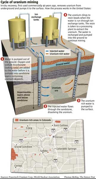
Federal officials withdrew a proposed requirement for companies to clean up groundwater at uranium mines across the U.S. and will reconsider a rule that congressional Republicans criticized as too harsh on industry.
The plan that the U.S. Environmental Protection Agency put on hold Wednesday involves in-situ mining, in which water containing chemicals is used to dissolve uranium out of underground sandstone deposits. Water laden with uranium, a toxic element used for nuclear power and weapons, is then pumped to the surface. No digging or tunneling takes place.
The metal occurs in the rock naturally but the process contaminates groundwater with uranium in concentrations much higher than natural levels. Mining companies take several measures to prevent tainted water from seeping out of the immediate mining area.
Even so, underground leaks sometimes occur, though most of the mines are not near population centers. No in-situ uranium mine has contaminated a source of drinking water, the industry and its supporters assert.
Along with setting new cleanup standards, the rule would have required companies to monitor their former mines potentially for decades. The requirement was set for implementation but now will be opened up for a six-month public comment period, with several changes.
Those include allowing the Nuclear Regulatory Commission or states to determine certain cleanup standards on a site-specific basis. The EPA decided to resubmit the rule and seek additional public input after reviewing earlier comments, agency spokeswoman Monica Lee said.
Wyoming’s Republican U.S. senators, John Barrasso and Mike Enzi, praised the EPA’s decision to reconsider, saying the rule was unnecessarily burdensome for the uranium industry.
Wyoming has five active in-situ uranium mines and is the top uranium-producing state. Other mines are active in Nebraska and Texas.
“In-situ uranium recovery has been used in the United States for decades, providing valuable jobs to Wyoming and clean energy to the nation,” Enzi said in a news release. “I rarely say this about the EPA, but the agency made the right decision.”
Environmentalists and others say uranium-mining companies have yet to show they can fully clean up groundwater at a former in-situ mine. Clean groundwater should not be taken for granted, they say, especially in the arid and increasingly populated U.S. West.
“We are, of course, disappointed that this final rule didn’t make it to a final stage,” said Shannon Anderson with the Powder River Basin Resource Council. “It was designed to address a very real and pressing problem regarding water protection at uranium mines.”
The EPA rule is scheduled for further consideration in President-elect Donald Trump’s administration.
In-situ uranium mining surged on record prices that preceded the 2011 Japanese tsunami and Fukushima nuclear disaster. Prices lately have sunk to decade lows, prompting layoffs.
From the Bureau of Land Management via the The Chaffee County Times:
The Bureau of Land Management and Park County have discovered the presence of dioxane, an industrial chemical, within a closed municipal landfill and on surrounding public lands approximately one mile south of Fairplay.
According to the Colorado Department of Public Health and the Environment, the chemical exceeds regulatory limits but would not cause harmful health effects based on detected levels of exposure.
Currently, the dioxane has been detected only on public lands. The BLM and Park County will conduct additional monitoring efforts to determine the nature and extent of contamination.
The BLM leased 20 acres of public land to Park County in 1974 for use as a landfill under the Recreation and Public Purposes Act. Park County operated the landfill from the early 1970s to the early 1990s.
The BLM Royal Gorge Field Office has been working with Park County and CDPHE to bring the landfill into compliance.
As part of this effort, the BLM installed two groundwater monitoring wells earlier this year to evaluate water quality.
If you are concerned about your health, you can drink and cook with bottled water to limit your exposure. BLM is notifying adjacent landowners directly.
Local landowners can contact Sheila Cross, Park County, at 719-839-4272 or scross@parkco.us to arrange groundwater testing or for more information on monitoring efforts.
Drought means different things to different people (or plants or animals). Click here to read a great paper by the late Kelly T. Redmond explaining how drought is classified by the pros.
Click here to go to the US Drought Monitor website. Here’s an excerpt:
Summary
A series of fast-moving Pacific storm systems raced eastward across the lower 48 States this week, bringing light to moderate precipitation to the Northwest, California, and along the southern tier of states. Once the systems reached the Southeast, they tapped moisture from the Gulf of Mexico and produced widespread and numerous heavy showers and thunderstorms, some severe, from southeastern Texas northeastward into the Carolinas. Copious rains fell across much of the Southeast, with more than 4 inches measured from extreme southeastern Texas northeastward into south-central South Carolina. Locally, 7-12 inches of rain was dumped on southern Mississippi northeastward into west-central Georgia. These rains fell on much of the Southeast drought area and provided welcome relief, especially in southern sections. Lighter precipitation (0.5-2 inches) also fell on most of the Northeast and Ohio Valley, including heavy snow (up to 2 feet in Maine) that blanketed parts of northern New England. Unfortunately, little or no precipitation fell on the Nation’s mid-section, particularly the south-central Plains and lower Missouri Valley, where above-normal temperatures and lingering dryness dating back to the Fall has generated impacts in Oklahoma that were worse than what the data indicated. Weekly temperatures averaged below-normal in the West (anomalies -10 to -15 deg F in the Interior Northwest and Great Basin) and much above-normal in the eastern half of the Nation (anomalies 10-15 deg F in the southern Great Plains and along the western half of the Gulf Coast)…
The Plains
While precipitation and drought improvement was ongoing in the Southeast and parts of the Northeast, very dry and mild weather continued across the middle third of the Plains. Since early October, less than half of normal precipitation has fallen across eastern Colorado, western Kansas, northern Texas, and much of Oklahoma, accumulating deficits of 2-4 inches. Although the past 90-days are typically a dry time of year, the lack of normal precipitation, above-normal temperatures, and gusty winds have exacerbated conditions, with impacts worse than what the indices and data are depicting. For example, NASS/USDA Oklahoma winter wheat conditions rated poor or very poor went from 12% on Nov. 27 to 25% on Jan. 1, while topsoil moisture rated short to very short rose from 55% on Nov. 27 to 70% on Jan. 1. There have been numerous reports of small ponds and watering holes drying up or very low in western, central, and northeastern sections of the state. As a result, D1 was expanded into south-central Oklahoma, D2 was expanded across the central and northeastern parts of the state and into northeastern Texas, and D3 was added to east-central Oklahoma and northwestern Arkansas where the deficits and SPIs were the worst. The only other degradation in the Plains was a slight increase in D0 in extreme south Texas. In contrast, enough rain fell across central and eastern Texas that some 1-category improvements were made. A slight reduction in the small D2 area in eastern Wyoming (Weston County) was done after reassessing the various indices and data. No other changes were made to the Plains…
The West
The week was rather cold and tranquil, with precipitation totals of 1.5-4 inches in the Cascades, 1-2 inches along the Oregon and northern California coasts, 1-2 inches in the Sierra Nevada, and 0.5-2.5 inches across the Southwest, including southern California and Arizona for the second consecutive week. Downtown Los Angeles recorded its wettest month (4.55 inches in December) since December 2010 (10.23 inches). Temperatures averaged below normal in the West, with anomalies of -10 to -16 deg F in eastern Oregon, southern Idaho, northern Nevada, and western Utah. As of January 3, NRCS basin average precipitation for the Water Year (since Oct. 1) was above normal in much of the West, with below-normal basins (70-99%) limited to parts of New Mexico, Colorado, and Wyoming. Basin average snow water content was also faring well, with most basins near or above normal as of Jan. 3. Some basins, however, in southern New Mexico, western Montana, northern Idaho, eastern Washington, and California were below normal. As a result of the wet start to the Water Year in southeastern California, southern Nevada, and southwestern Arizona (and supported by indices and lack of negative impacts), a 1-category improvement was made there. In southern Utah (San Juan and Kane counties), with snowpack levels above normal and indices near normal, the D0 was removed. Elsewhere, status-quo was maintained in the rest of the West after several improvements were made the previous 2 weeks…
Looking Ahead
During the next 5 days (January 5-9), several Pacific storm systems laden with moisture are expected to batter California and the West, with up to 18 inches of precipitation forecast for the Sierra Nevada Mountains. Coastal areas of Oregon and the northern two-thirds of California are expecting more than 4 inches of precipitation, while the Intermountain West, northern, central, and southern Rockies, and Cascades may see 1-3 inches. Unfortunately, little or no precipitation is predicted in the middle third of the Nation (including the Plains), while a storm may develop off the Atlantic Coast. Light totals (less than 1 inch) may occur along the eastern Gulf and south Atlantic Coasts, with lake-effect snows likely in the favored Great Lakes snow belts. Temperatures across much of the lower 48 States should be well-below normal except above-normal in the Southwest.
During January 10-14, the odds favor above-median precipitation in the West, northern Plains, Midwest, Northeast, and northern Alaska, with good chances for sub-median precipitation in the southern Rockies, southern half of the Plains, along the Gulf and southern Atlantic Coasts, and the southern half of Alaska. Temperatures are expected to rebound from Days 1-5 cold spell, with a favorable tilt toward above-normal readings across the southern half and eastern third of the U.S., with the cold expected to remain in the Northwest, northern Plains, and southeastern Alaska..
The Durango City Council approved a long-awaited lease Tuesday that will allow the city to manage recreation at Lake Nighthorse.
“We have been waiting for this to be on the agenda since 2009,” Mayor Christina Rinderle said.
The 25-year lease will now be sent to the Bureau of Reclamation, which owns the property, for approval, Parks and Recreation Director Cathy Metz said in an interview.
The city agreed to manage recreation at Lake Nighthorse because in 2008 Colorado Parks and Wildlife declined to do it.
The lease agreement is a big step, City Attorney Dirk Nelson said. But the city is not legally ready to open the property yet.
“This isn’t ours to open or close,” Councilor Dean Brookie said.
The city must annex the property; a planning-and-development memorandum of understanding must be signed; and necessary infrastructure, including a dock, must be built.
The city does not have a set time frame for opening the lake yet, Metz said.
“I can promise that we will make that known as soon as we can,” she said.
However, the lease will allow the city to make a good case for keeping some of the grants it has already received for construction of amenities around the lake, including a $3 million state grant that has not been completely spent, City Manager Ron LeBlanc said.
Another $285,000 grant from Colorado Parks and Wildlife will help pay for a boat dock, an overflow parking area and to chip seal the road from County Road 210 to the boat ramp, Metz said.
The lease between the Bureau of Reclamation and the city will allow Parks and Wildlife to fund these projects.
A grant through the Bureau of Reclamation is also paying for an entrance station where boats will be inspected. This construction is underway, and it will be completed in 2017, Metz said.
Once the lake is opened, the city expects user fees to cover the operation of the area, she said.
If the city faced a shortfall in operational revenue, the city and the Bureau of Reclamation would split that cost, but only if the money was approved by the City Council and the U.S. Congress, she said.
Similarly, the city and the bureau could split the cost of future construction projects, she said.
The cost-sharing is specified in the lease, she said.
However, the bureau will own any structures that it funds, according to the lease.
As part of its management plan, the city plans to annex the 1,500 acres of surface water, about 500 acres of land on the east side of the lake, as well as a narrow band of land around the whole lake. This will allow city police officers to patrol the area.
A swimming beach, natural surface trails, camping and picnic areas are planned for the annexed area, but they will be phased in later.
Limiting the annexation to certain areas is meant to protect archaeological sites, Metz said.
During a December meeting of the Natural Land Preservation Advisory Board, Metz said that a plan to manage hunting near the lake must also be agreed upon as part of the preparation to open the lake.
While hunting would not be allowed on annexed land, it could be allowed on adjacent land.
The city plans to work with Colorado Parks and Wildlife and the Southern Ute Indian Tribe on hunting management, Metz said.
The lake could offer an area for water fowl hunting that isn’t available close to Durango, said Steve McClung, representing Colorado Parks and Wildlife as a nonvoting member natural land board.
From the Nebraska Department of Natural Resources via The McCook Gazette:
The Nebraska Department of Natural Resources has determined that 2017 is a “Compact Call Year.”
On Dec. 31, 2016, DNR director Gordon W. Fassett made the announcement that this year is a “call year” according to provisions of and resolutions regarding the 1942 Republican River Compact between Nebraska, Kansas and Colorado.
Nebraska will now have to comply with terms of the Compact’s 2016 resolution, including providing Kansas with the ability to either call for delivery of its share of Republican River water as needed (from water storage in Harlan County Lake), or leave it in ground and available to Kansas water users at some future time when it’s needed more.
The resolution signed by the three states in August 2016 provides Kansas water users much more certainty that there will be a viable irrigation supply in dry periods. Nebraska will receive full credit in Compact accounting for its compliance activities, including its augmentation deliveries, provided that the water generated by its activities (“Compliance Water”) is delivered to Harlan County Reservoir in Nebraska for Kansas water users’ use.
During Compact Call Years, the Nebraska DNR regulates and administers surface water in the Republican River basin upstream of the Guide Rock Diversion Dam to ensure Nebraska’s compliance with the Compact, issuing the necessary closing notices on natural flow and storage permits in the basin until such time as DNR and river basin Natural Resources District determine that administration is no longer needed to ensure Compact compliance.
The Republican River Compact, signed Dec. 31, 1942, entitles Nebraska to 49 percent of the river’s water, while Kansas receives 40 percent and Colorado gets 11 percent. The Republican River originates in Colorado, crosses the northwestern tip of Kansas into Nebraska, then runs through Nebraska before re-entering Kansas in its northeastern corner.
Grand County Water Quality Specialist Katherine Morris and contract employee Lurline Underbrink-Curran gave a water quality update at the first Board of County Commissioners (BOCC) meeting of 2017.
WINDY GAP BYPASS
On Dec. 21, 2016 the Natural Resources Conservation Service, part of the federal US Department of Agriculture, announced The Colorado River Headwaters Project (CRHP) would receive a $7.75 million grant to apply to a series of river restoration and conservation projects in Grand County. The grant, totaling $7,758,830, comes to the CRHP through the Regional Conservation Partnership Program (RCPP), part of the NRCS. The grant equals 80 percent of the requested amount. Underbrink-Curran said, in an update, that there are several sources the RCPP will apply to for the remaining funds. With the amount of money secured, other funders may be more willing to sign on to a project that has the ability to be completed and do such great things for the environment, fish passage, water quality and temperature and agriculture.
The $7.75 million grant will be divided up between a series of water projects including the creation of a bypass channel that will connect the Colorado River below the Windy Gap Reservoir to the sections of the River above the Reservoir. A significant portion of the funds will also be used to improve river habitat downstream from the Windy Gap as well as improving irrigation systems for irrigating ranchers in the Kremmling area and to improve soil and water quality.
According to Underbrink-Curran, the water right issue for the bypass channel has made some progress. At the last meeting there was a real effort to find a path that all could agree upon. Steve Bushong with UCRA had drafted a position that all agreed might work. That draft was circulated with the attorneys and has undergone several revisions and inclusions but seems to be getting close to complete.
UPRR INJECTION WELL
Morris said in December of 2016 the Water Quality Board requested she submit a letter to the Colorado Department of Public Health and Environment (CDPHE) expressing the board’s dissatisfaction of a revised discharge permit for Union Pacific Railroad (UPRR).
UPRR plans to submit a Class V Injection Well permit for a site near the Moffat Tunnel in Winter Park. Class V wells are used to inject non-hazardous fluids underground. Most are used to dispose of waste into or above underground sources of drinking water. This disposal can pose a threat to ground water quality if not managed properly.
According to UPRR, The plant would treat and return 95 percent of the contaminated groundwater issuing from the tunnel and return it, clean, to the Fraser River.
Grand County shared their concerns with the Environmental Protection Agency (EPA) stating that the plant was designed to treat only metals and total suspended solids (TSS), but the current discharge permit only recognizes TSS and metals as contaminants. According to Morris, Grand County does not know what will be the fate of the organic pollution that will also be in the discharge during annual tunnel cleaning operations, which is what caused the pollution found in September.
Morris said she has not drafted the letter yet because the permit has not been released.
BERTHOUD PASS SEDIMENT CONTROL
Morris said the Colorado Department of Transportation (CDOT) is asking for comments by Jan.30 on a draft Berthoud Pass Sediment Control Action Plan (SCAP). The SCAP will identify potential scenarios for enhanced maintenance and sediment control features to be implemented when funding becomes available. The last meeting about this effort took place in October of 2015. Morris said she will be reviewing the SCAP this month.
Black Hills Energy believes the best use of its limited water rights for the old Power Stations 5&6 is to donate that water — and the equipment that carries it — to the Pueblo Board of Water Works and the city of Pueblo.
The utility makes that argument in a Dec. 20 filing with the Colorado Public Utilities Commission.
Black Hills was ready to carry out that water transfer last month when Commissioners Joshua Epel and Glenn Vaad stopped the process and asked that Black Hills explain why it wasn’t attempting to sell the water rights instead of donating them.
Vaad said the sale of the water could be used to lower costs for Black Hills ratepayers.
In practical terms, the Black Hills water is used to help fill the channels of the Historic Arkansas Riverwalk of Pueblo, so having the water sent elsewhere would pose a major problem to the Pueblo attraction.
Commissioner Frances Koncilja, a Denver attorney but Pueblo native, disagreed with Epel’s and Vaad’s interim order and said her colleagues were meddling with a win-win agreement for the Pueblo utility, but the order was issued.
In its Dec. 20 response, Black Hills officials explain that the limited amount of water it has rights to for cooling the old power station has such limited uses that selling them seemed impractical while donating them to the city and the water board was a better option.
“Our donation of the water rights . . . will provide an immediate benefit to the Pueblo Board of Water Works, the city of Pueblo and the community at large, because it will be a significant contribution towards the continued viability of the hub of Pueblo’s Downtown and a key tourist attraction — the HARP,” the brief says.
What the commission will do next is less certain. Epel, who’d been chairman for six years, resigned from the commission effective Jan. 3 and Vaad announced he would retire. Gov. John Hickenlooper on Wednesday nominated Jeff Ackerman and Wendy Moser to the commission for terms effective Monday, but both have to be confirmed by the Senate.
State Sen. Leroy Garcia, D-Pueblo, was one of a group of Southern Colorado lawmakers who backed Koncilja’s appointment to the commission earlier this year and in December, he said he would urge Hickenlooper name her chairman.
The Pueblo Levee Dredging and Maintenance Project, which will run through April, is being undertaken to improve the flood carrying capacity of Fountain Creek from the confluence with the Arkansas River upstream to the East Eighth Street bridge.
The work also will see the removal of undesirable vegetation on the east levee embankment (stream side only), on the east bank of the creek and on a portion of the west bank of the creek.
The work is being handled by Sun Construction, which has contracted with the Fountain Creek Watershed, Flood Control and Greenway District.
After the dredging of the creek, the bed material will be hauled by trucks to disposal sites. The work also will include the demolition of two of the abandoned railroad bridge piers.
Truck and equipment access to the creek will be from two staging areas on city property — one at the location off South Joplin Avenue near the abandoned railroad bridge and the second at the west end of East 11th Street.
During the project, the contractor will manage vehicle traffic interactions on public streets and with traffic on the river trail adjacent to the levee. Currently, the bike trail on the east side of the river is closed.
Removal of vegetation on the east and west banks will be limited to non-native, “invasive species” and will not include desirable species such as willows and cottonwoods.
Removed vegetation on the east levee and invasive species will be treated with a herbicide to hinder regrowth.
The removal of vegetation is expected to occur between April and August.
The city will benefit from the delivery of about 55,000 cubic yards of material that will be trucked to sites near Lake Minnequa and near Plaza Verde Park.
While the dredging and demolition will continue through April, the operation will be suspended during the period of higher creek flows — until approximately August and concluding by the end of December.
A community that does not have enough water is a community that does not survive, and Fort Morgan city leaders want to ensure that is not what happens here.
As such, the Fort Morgan City Council approved continuing the city’s role in the Northern Integrated Supply Project and the $360,000 expenditure that will require in 2017.
Fort Morgan has been gambling on NISP, a massive water storage project, getting permitted and built for 13 years now, according to Water Resources/Utilities Director Brent Nation.
But it’s a gamble that could pay off in water security for as long as the next five decades, according to City Manager Jeff Wells.
About NISP
That’s because NISP would include Northern Colorado Water Conservancy District (aka Northern Water) building both Glade Reservoir north of Fort Collins and Galeton Reservoir northeast of Greeley and east of Ault.
If these reservoirs get built, it would mean “40,000 acre feet of new, reliable water supplies” for the 15 NISP participants, which include Fort Morgan, Morgan County and Morgan County Quality Water District.
But getting it built involves both completion of the final environmental impact statement for he project and getting a record of decision on a permit from the U.S. Army Corps of Engineers.
As of January 2017, Northern Water was estimating that the Corps likely will finish the FEIS yet this year and then issue the record of decision on the permit sometime in 2018.
Large cost, lengthy timeline
Fort Morgan, alone, will have spent more than $1.3 million toward NISP and the city’s 9 percent stake in it over the project’s 13 years of planning and studies. And there could be another 10 to 12 years yet to go before NISP and its reservoirs conceivably would go online and the city would have water stored in Galeton Reservoir and pumped back to Fort Morgan.
As the project progresses, the city’s annual payments for it will get larger and larger, Nation warned. He called the 2017 one among the last of the “smaller payments.”
Depending upon what the Corps does this year, the larger NISP payments could start next year.
“Next year, in 2018, we’ll start moving into the larger engineering payments, and then hopefully within a year or two after that we’ll be moving into construction-type payments, where we’re getting into millions of dollars for our portion of that work,” Nation said.
Regardless, if and when it does get built, NISP would provide enough water to give the city water security for the future and whatever residential, commercial and industrial growth may come, according to Mayor Ron Shaver, Wells and Nation.
And such a lengthy timeline is not unusual for this large of a water storage project, according to both Nation and officials from Northern Water.
Reasons to continue
But continuing to support it will be worth it for the city in the long term, Nation stressed.
He shared his reasons why the city should “move forward on this project” with the council.
“We continue to exist on a base water supply that we have to rent what we need for our current needs. We still have times of the year where we’re using some rental C-BT water in order to meet all of our water demands,” Nation said.
Also, the Fort Morgan Water Treatment Plant is experiencing record levels for demand for treated water, with 1.5 billion gallons treated over the last 12 months.
“Six out of the last seven months we had record production at treatment facility,” Nation said, adding that the local industry was “driving those numbers.”
Specifically, large industrial water customer Cargill Meat Solutions is continuously pulling in water.
“We’re not seeing a lot of downtime with Cargill,” Nation said. “And even when they’re down on that seventh day, they’re using a lot of water just to clean the facility.”
And expansions at both the Leprino Foods cheese plant and the Western Sugar Cooperative beet plant have meant increased demand for water from Fort Morgan.
“We just continue to see our industrial/commercial numbers go up as we continue just to exist at the current population that we’re at,” Nation said. “It kind of drives home to me that this project is important to us. It’s something that we need to continue to participate in and see it to the finish line. This is something we need as a community.”
Wells agreed, adding that the city has previously looked into many other options for obtaining enough water for the city’s future.
“Today, there are no more viable alternatives than NISP for the city of Fort Morgan,” he said.
Shaver, who served as the city’s utilities director before retiring from the city and then serving on the council and now as mayor, said NISP is what the city needs for its future.
Northern Integrated Supply Project (NISP) map July 27, 2016 via Northern Water.
Click here to read the Fall issue of Headwaters Magazine from the Colorado Foundation for Water Education. Here’s their intro:
The Fall 2016 issue of Headwaters magazine looks at public health. The magazine introduces the law and policy governing safe drinking water, then takes a close look at how public health concerns related to as-yet-unregulated contaminants are monitored and evaluated. The issue also focuses on the unique public health challenges rural areas face, while exploring efforts to pursue increased water reuse, including from direct potable reuse systems, through initiatives related to technology and policy. The issue’s articles are set against the backdrop of public alarm raised about the safety of public water during recent high-profile events, including Flint’s lead crisis and PFC groundwater contamination near Colorado Springs. Flip through or download the issue here
Be sure to check Allen Best’s article about reuse, Water on Repeat. Here’s an excerpt:
Castle Rock and other water providers in Denver’s South Metro area understand the need to diversify their water supplies. One big piece of that puzzle is wa- ter reuse. You’ve heard of locovores, people who favor locally sourced food? This is similar. Call it locoagua. Rather than import water from distant sources, these water-strapped communities can reuse certain water supplies again and again, until they are exhausted. For many communities, it’s the lowest-cost alternative. Given proper treatment, it can be the highest-quality alternative, too.
Colorado Springs is opposing an Arkansas River water district’s request to join a lawsuit that seeks to stop the city from discharging pollutants into Fountain Creek and other tributaries of the river.
The Lower Arkansas Valley Water Conservancy District wants a voice against Colorado Springs by being allowed to take part in the litigation.
The U.S. Environmental Protection Agency and the Colorado Department of Health jointly filed the lawsuit Nov. 9 in U.S. District Court in Denver against Colorado Springs. The lawsuit claims that the city’s discharges of polluted stormwater into the tributaries violate state and federal clean water laws.
The lawsuit seeks a court order requiring Colorado Springs “to take all steps necessary to redress or mitigate the impact of its violations.”
The lawsuit also seeks a court order to require the city “to develop, implement and enforce” its stormwater management program, as required by permits the government has issued. The lawsuit goes on to ask a judge to impose monetary penalties on Colorado Springs for the violations.
Water runoff from streets, parking lots and other surfaces picks up pollutants that drain into the stormwater sewage system, which discharges it into the creeks.
Pollutants include accumulated debris, chemicals and sediment. They “can adversely affect water quality, erode stream banks, destroy needed habitat for fish and other aquatic life, and make it more difficult and expensive for downstream users to effectively use the water,” the lawsuit states
The water district on Dec. 9 asked Senior Judge Richard Matsch for permission to become an intervenor to protect the district’s interests to have clean and usable water from the river.
The city on Dec. 22 filed arguments opposing the district’s request. The city contends that the district has no legal right to intervene.
The district — as well as Pueblo officials — has long been a critic of Colorado Springs for sending polluted and sediment-filled stormwater, including dangerous E. coli bacteria, into the river and for not controlling flooding the water causes.
The district encompasses Bent, Crowley, Otero, Prowers and Pueblo counties, where considerable produce, including Rocky Ford melons, are grown.
Colorado Springs officials have negotiated a deal with Pueblo County for the city to spend $460 million over 20 years on Fountain Creek flood control.
The Gazette newspaper in Colorado Springs reported last Friday that Mayor John Suthers cited that commitment as an example of how his administration is working to resolve the complaints of its downstream neighbors.
In its court filing opposing allowing the district to become a participant in the litigation, the city said the case will be greatly complicated and costs of litigating it will increase. The city also said that the EPA and state environment department will adequately represent the district’s interests.
Attorney Peter Nichols, representing the district, sees it differently, according to The Gazette: “The question is whether the city is already putting a lot of political pressure on the state and EPA to back off. The district is concerned they might be successful with that pressure, and water quality wouldn’t be improved in Fountain Creek,” Nichols said.
The newspaper reported that district Executive Director Jay Winner said Colorado Springs repeatedly had broken promises about the stormwater problems.
Bicycling the Colorado National Monument, Grand Valley in the distance via Colorado.com
FromThe Grand Junction Daily Sentinel (Erin McIntyre):
If you notice that some fields across the valley remain bare when others are sprouting with crops this spring, don’t be alarmed.
Behind those temporarily empty rows is an innovative experiment targeting water savings.
Farmers with the Grand Valley Water Users Association are participating in a pilot study to help determine if it’s feasible to intermittently fallow fields to save water in reservoirs.
The move to pay those in the agricultural community to not plant a portion of their crops is the first time an experiment of its kind has been done in the Grand Valley, and it’s one that could change the way water providers operate in the future to conserve precious resources during drought.
With reservoir levels dwindling and low snowpack levels across many areas in the West, water managers are trying this new tool out to see if it could help them hedge against dry years and protect against catastrophe that could result from scarcity along the Colorado River.
This experiment has a goal of helping to shore up water reserves in Lake Powell, which isn’t just a recreation destination, but an insurance policy to protect Upper Basin states like Colorado against demands on water from the Lower Basin, including California.
The Conserved Consumptive Use Pilot Project began last year, and 10 farmers were chosen from a lottery to participate in the program, which compensates them for not planting a portion of their fields. Instead, the water would be banked in storage, hedging against scarcity in times of drought.
The initial phase of the pilot project is projected to save 3,200 acre-feet of water, which is a drop in the bucket of the 7.5 million-acre feet of Colorado River water earmarked for delivery to Arizona, Nevada and California per year by compact agreement. But it’s a start in exploring how water managers can be flexible and avoid heavy-handed edicts from the federal government, pilot participants said.
“We’re trying to find ways to protect ourselves,” said Luke Gingerich, an engineer contracted to manage the pilot program with GVWUA Manager Mark Harris.
“How do we get ahead of this curve for our benefit?” Harris said. “And how do we do it without damaging people’s interests?”
Organizers of the project have spent extensive time researching the legal implications of fallowing fields and leaving agricultural water in the stream to collect in reservoirs.
Farmers interested in the pilot needed to meet several criteria. They needed to be actively farming at least 120 acres for the past three years, and could only commit half of their acreage for fallowing, among other rules. Some of the stipulations are meant to discourage speculation, which has happened in other lease-fallow situations, Gingerich said.
Commodity prices for crops are hovering near multiyear lows, making the deal more attractive for farmers who are guaranteed at least $356 per acre for participation in the pilot.
Harris called the record-low commodity prices in agriculture an “unhappy coincidence” that may have led some farmers to be more open to the experiment. He said some growers were attracted to the staggered fallowing agreements, allowing them to fallow until August, September or October, which would allow them to plant crops like winter wheat for the next season. Overall, the fallowed land is distributed across the association’s service area, and amounts to less than 5 percent of the total acreage.
The pilot project is about building a contingency plan, preparing for the worst-case scenario. In this case, that would be if water levels at Lake Powell drop below the point where power can be generated, which would likely trigger water curtailment in Colorado and other Upper Basin states.
The program has been funded by a number of entities, including the Colorado River Water Conservation District, the Nature Conservancy and the Water Bank Work Group.
Dan Birch, deputy general manager of the Colorado River Water Conservation District, said his agency has been working on this plan for about eight years. He said the motivation is to find a sensible compromise to avoid dire consequences if Lake Powell’s water levels continue to drop.
“What’s going on overall in the Colorado River system is, things aren’t that good,” Birch said. “You really don’t have to look any further than the reservoir levels in Lake Powell and Lake Mead. Those are our savings accounts.”
The reality that water managers are facing is that if water demands continue to increase while snowpack levels dwindle, everyone who depends on the Colorado River isn’t more than a few dry years away from dire straits, said Hannah Holm, coordinator of Colorado Mesa University’s Hutchins Water Center.
“It’s just becoming more and more clear that the Colorado River Basin as a whole could be in real trouble because there’s more water coming out of our system than what’s going into the system, since about 2000,” Holm said. “This is an effort to get in front of it and avoid a crisis.”
For decades, the [Colorado River] has fed growing cities from Denver to Los Angeles. A lot of the produce in supermarkets across the country was grown with Colorado River water. But with climate change, and severe drought, the river is reaching a crisis point, and communities at each end of it are reacting very differently…
The problem is that Colorado’s population will nearly double by 2050. Future residents will need more water. Denver Water CEO Jim Lochhead says more storage is part of the solution. It’s also an insurance policy against future drought.
“From Denver Water’s perspective, if we can’t provide clean, reliable, sustainable water 100 years from now to our customers, we’re not doing our job,” Lochhead says.
Demand for Colorado River water is already stretched thin. So it may sound crazy that places like Colorado and Wyoming want to develop more water projects. Legally, that’s something they are entitled to do.
Wyoming is studying whether to store more water from a Colorado River tributary. “We feel we have some room to grow, but we understand that growth comes with risk,” says Pat Tyrrell, who oversees Wyoming’s water rights.
Risk because in 10 or 20 years there may not be enough water to fill up expanded reservoirs. A 16-year drought has dramatically decreased water supply even as demand keeps growing. And climate change could make this picture worse.
It makes Tyrrell’s job feel impossible.
“You understand the reality today of a low water supply,” he says. “You also know that you’re going to have permit applications coming in to develop more water. What do you do?”
Tyrrell says that as long as water is available, Wyoming will very likely keep finding new ways to store it. But a future with less water is coming.
In California, that future of cutbacks has already arrived. The water that started in Colorado flows more than 1,000 miles to greater Los Angeles.
So even in the sixth year of California’s drought, some lawns are still green.
“Slowly but surely, the entire supply on Colorado River has become less reliable,” says Jeffrey Kightlinger, who manages the Metropolitan Water District in Southern California. He notes that the water level in Lake Mead, the biggest reservoir on the river, has been plummeting.
An official shortage could be declared next winter. “And that’ll be a historic moment,” Kightlinger says.
It’s never happened before. Arizona and Nevada would be forced to cut back on how much water they draw from the river. California would be spared that fate, because it has senior water rights. So you wouldn’t expect to hear what Kightlinger says next.
“We are having voluntary discussions with Arizona and Nevada about what we would do proactively to help,” he says.
California could help by giving up water before it has to, between 5 percent and 8 percent of its supply. Kightlinger isn’t offering this out of the goodness of his heart; if Lake Mead drops too low, the federal government could step in and reallocate all the water, including California’s.
“We all realize if we model the future and we build in climate change, we could be in a world of hurt if we do nothing,” Kightlinger says.
This idea of cooperation is somewhat revolutionary after years of lawsuits and bad blood.
Recently, farmer Steve Benson was checking on one of his alfalfa fields near the Mexican border. “We know there’s a target on our back in the Imperial Valley for the amount of water we use,” he says.
This valley produces two-thirds of the country’s vegetables in the winter — with water from the Colorado River.
In fact, for decades, California used more than its legal share of the river and had to cut back in 2003. This area, the Imperial Irrigation District, took the painful step of transferring some of its water to cities like San Diego.
Bruce Kuhn voted on that water transfer as a board member of the district. “It was the single hardest decision I have ever made in my life,” he says.
Kuhn ended up casting the deciding vote to share water, which meant some farmers have had to fallow their land.
“It cost me some friends,” he says. “I mean, we still talk but it isn’t the same.”
Soon, Kuhn may have to make another painful decision about whether California should give up water to Arizona and Nevada. With an emergency shortage looming, Kuhn may have no choice.
Click here to listen to the latest podcast from David McGimpsey. Here’s his intro:
Recently, I was fortunate enough to moderate a panel discussion at the opening plenary session of the American Water Resources Association’s 2016 Annual Conference, which took place in Orlando, Florida. The panelists were fantastic: Lester Sola and Hardeep Anand, the Director and Deputy Director, respectively, of the Miami-Dade Water and Sewer Department, Cindy Wallis-Lage, the President of Black & Veatch’s Water Business, and Shawn Grindstaff, Senior Resolution Counsel at the US EPA. This week’s podcast is the Q&A session from that conference – a big thanks to the AWRA and to each panelist for allowing the session to be recorded and released as a podcast. Give a listen for terrific insights on a wide range of water resources resiliency issues from these tremendous panelists.

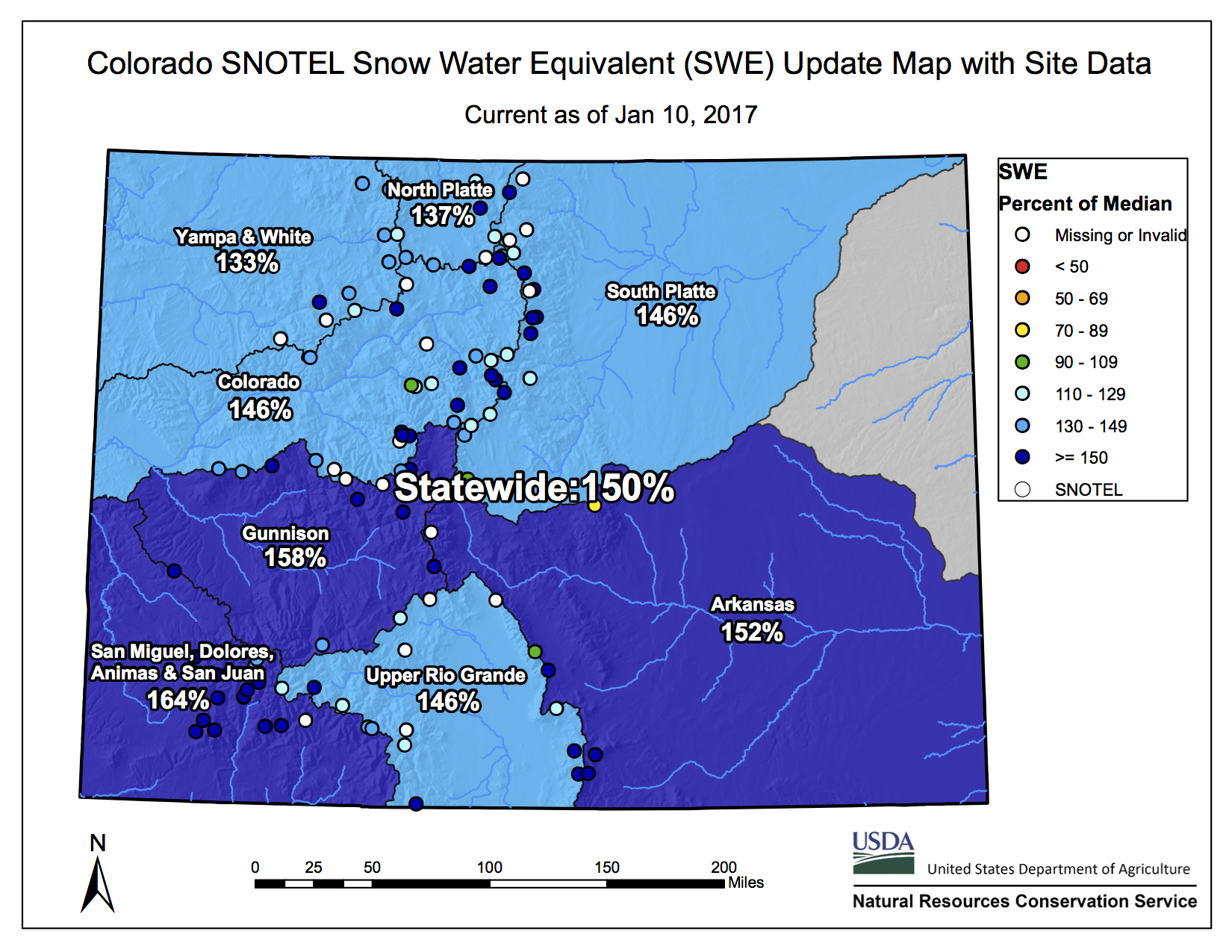
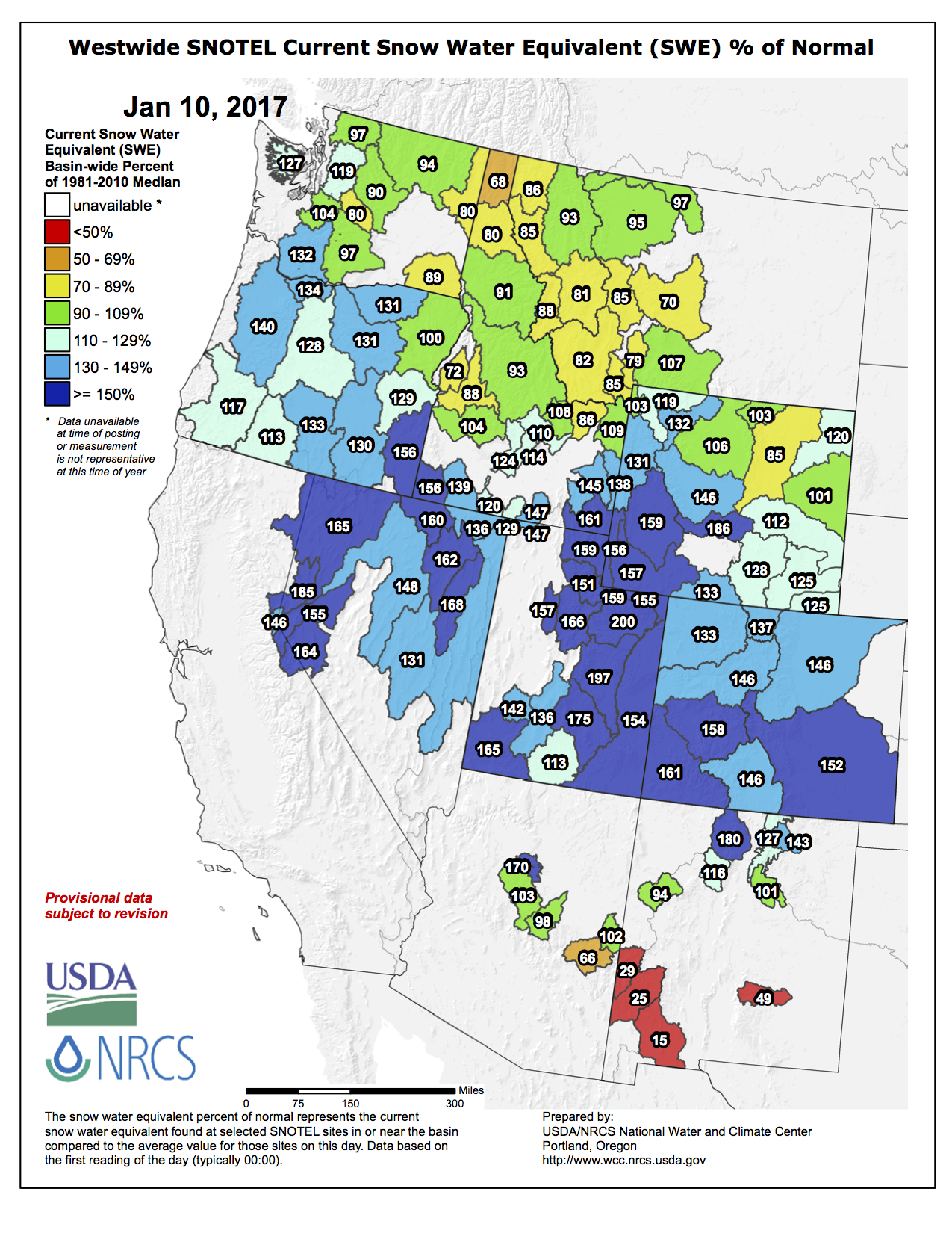


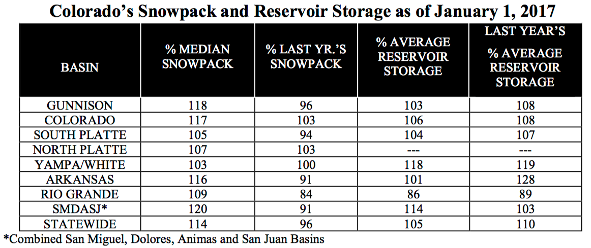


![Scott Hummer, general manager of North Poudre Irrigation Company, talks about how his agency worked with Fort Collins Natural Areas and Colorado Parks and Wildlife to include a fish passage when the irrigation company replaced a diversion structure on the Poudre River that was destroyed by the 2013 floods. Work was completed [in February 2016]. (Pamela Johnson / Loveland Reporter-Herald)](https://coyotegulch.blog/wp-content/uploads/2016/03/cachelapoudrefishpassage022016lovelandreporterheraldscotthummer.png)


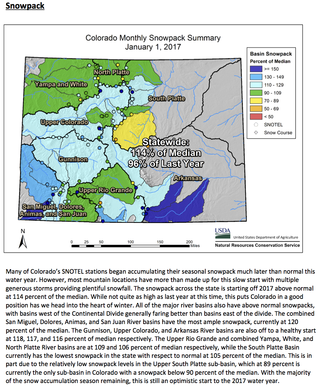
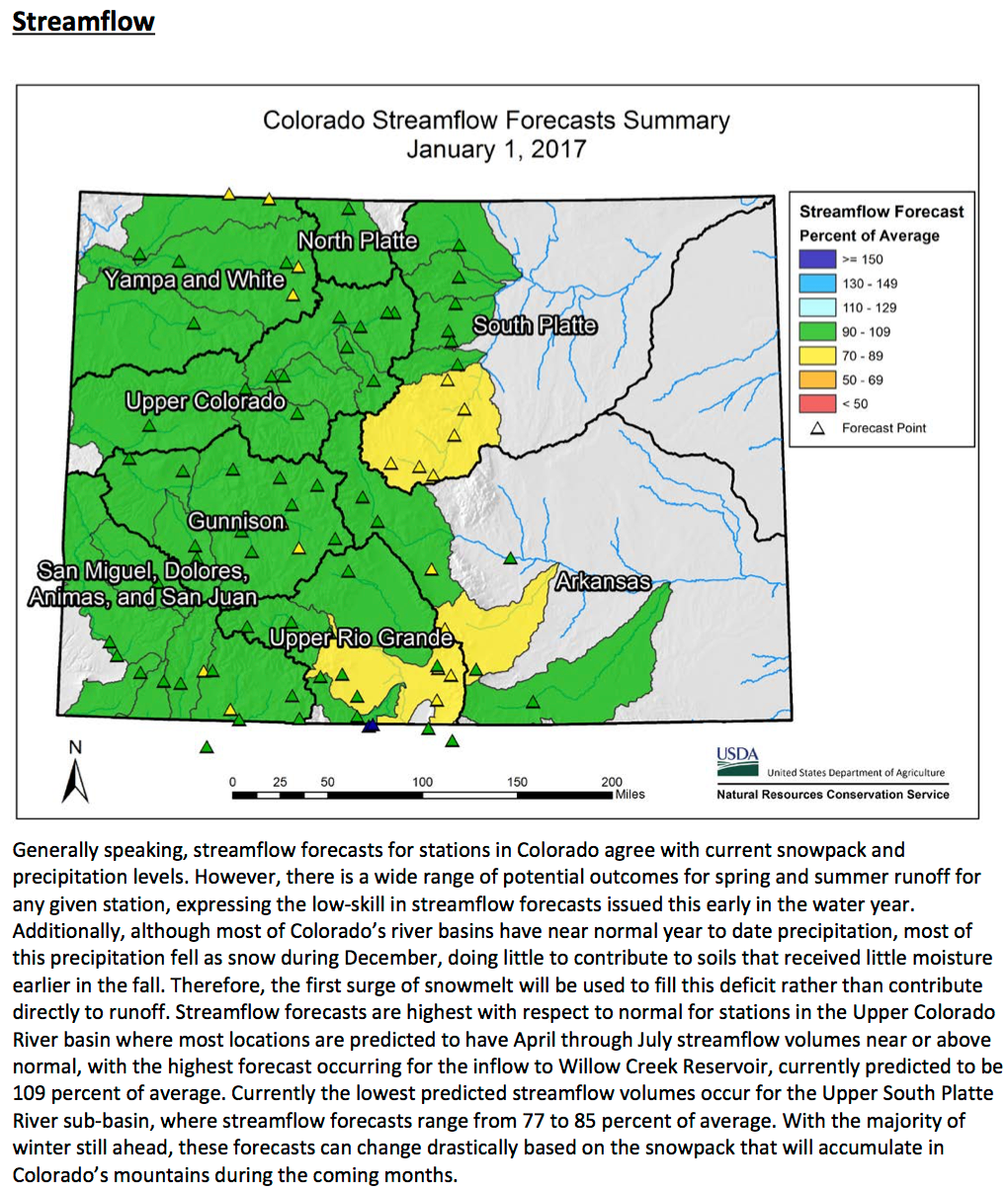


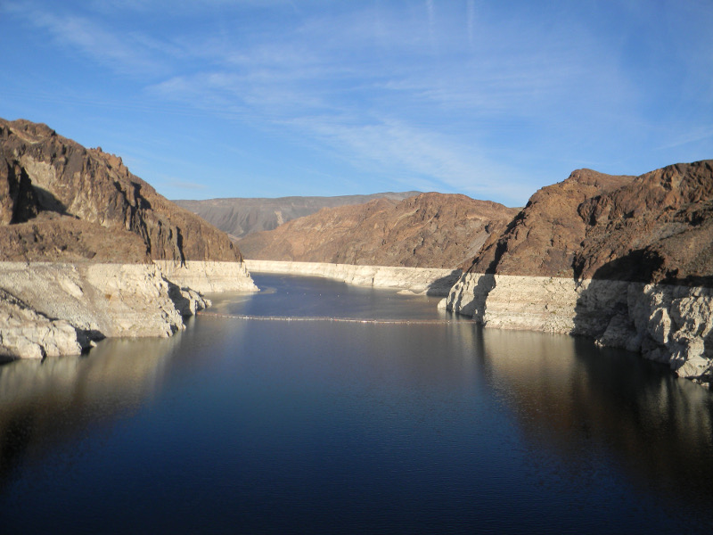
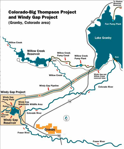


![This image was taken during the peak outflow from the Gold King Mine spill at 10:57 a.m. Aug. 5. The waste-rock dump can be seen eroding on the right. Federal investigators placed blame for the blowout squarely on engineering errors made by the Environmental Protection Agency’s-contracted company in a 132-page report released Thursday [October 22, 2015]](https://coyotegulch.blog/wp-content/uploads/2015/10/goldkingminespill1057am08052015viaepa.png)