#Snowpack news: Cold temperatures helping to preserve SWE

Click on a thumbnail graphic below to view a gallery of snowpack data from the NRCS.

And here’s the Westwide SNOTEL basin-filled map for today from the NRCS.

Westwide SNOTEL basin-filled map February 2, 2017 via the NRCS.

Battlement Mesa: Boring for water pipeline encounters high groundwater flows

Parachute/Battlement Mesa area via the Town of Parachute.

From The Grand Junction Daily Sentinal (Dennis Webb):

Summit Midstream ran into the problem Jan. 18 after it had nearly completed horizontally drilling a pilot bore for a water pipeline that will connect two Ursa well pads in Battlement Mesa, an unincorporated residential community of several thousand residents. A contractor for Summit struck a spring about 55 feet underground and water began gushing at estimated rates of as much as 294,000 gallons a day.

The incident initially forced the company to operate trucks 24 hours a day and to do work on a Sunday as it hauled off the water. That prompted several residents affected by the traffic to file complaints with the Colorado Oil and Gas Conservation Commission and Garfield County. A county approval condition for the pipeline project generally limits construction operations to 7 a.m. to 7 p.m., Mondays through Saturdays. But it allows for Sunday work if field conditions or inclement weather make it necessary.

On Jan. 25, Summit obtained a permit from the state Water Quality Control Division to discharge water from the flow into the Colorado River so it didnā€™t have to keep trucking away the water.

Leonard Mallett, Summitā€™s chief operations officer, said Tuesday that the flow from the spring has diminished quite a bit. He said the company hoped to pull pipe through the hole on Wednesday, and then inject a slurry grout around the pipe in the week, which should provide a seal and end the groundwater flow.

The water pipeline will allow for movement of hydraulic fracturing fluid and wastewater associated with gas development. Summit also will be installing a parallel natural gas pipeline about 50 feet from the water line. Mallett said it will be routed along a different angle and depth to avoid the spring…

He said the groundwater is being routed into a kind of ditch or waterway on private land to reach the river, and is staying within the banks.

Summit officials said in a written statement to the Daily Sentinel that Summit kept water from reaching the river or any other waters of the state prior to receiving the discharge permit. It says it pursued the permit after testing showed only groundwater was involved.

Lillian Gonzalez, a permit manager for the Water Quality Control Division, said itā€™s possible to run into groundwater during excavation for any kind of construction project, and to need to remove the water. Options can range from letting it evaporate in a lined pond, to hauling it to a facility that can handle it, to getting a permit to discharge into the waters of the state.

She said the Summit Midstream permit was issued under an assumption that the groundwater isnā€™t contaminated. Thatā€™s based on the fact that thereā€™s no known nearby groundwater contamination in the area.

However, Summit is required to test the water for acidity, oil and grease, and total dissolved and suspended solids, and must limit the discharge to 400 gallons per minute, or 576,000 gallons a day.

Gonzalez said typically the biggest concern with such permits is making sure the suspended solids limit is met because of the loose dirt associated with excavation work. A company may have to filter the water before discharging it, she said…

How much water does it take to throw a Super Bowl bash? – News on TAP

From jerseys to chicken wings, it takes hundreds of gallons of water to produce your game-day favorites.

Source: How much water does it take to throw a Super Bowl bash? – News on TAP

Winter snowpack makes its greatest comeback ever – News on TAP

After a slow, dry start to the snow season, this yearā€™s precipitation rebound became the most dramatic on record.

Source: Winter snowpack makes its greatest comeback ever – News on TAP

Fewer Days Below 32Ā°F — Climate Central

fewerfreezingdays

From Climate Central:

Warmer winters may sound great at first ā€” fewer icy roads, less scraping your car ā€” but milder weather has some major downsides. Everything from agriculture to wildlife to human health can be seriously impacted. Warmer winters also pose serious economic consequences in many states reliant on revenue from winter sports and recreation.

The number of days below 32Ā°F in the U.S. has been declining. As the map above ā€” adapted from a 2016 Journal of Climate paper ā€” demonstrates, this trend is projected to continue, threatening many of the winter activities that rely on cold conditions, including skiing, snowmobiling, ice fishing, and outdoor ice hockey.

These winter recreational activities are an integral part of the economy in many states. Data from 2009-10 show that the ski, snowboard, and snowmobiling industries were directly and indirectly responsible for employing 211,900 people and adding an estimated $12.2 billion in economic value to the U.S. economy. As winter loses its chill, these winter tourism activities will be impacted and with them, peopleā€™s livelihoods.

For some winter activities, you need more than simply temperatures below freezing ā€” you need snow. A Climate Central report found that at least 58 percent of more than 2,000 weather stations reported a trend toward a smaller percentage of all winter precipitation falling as rain instead of snow, with the Northwest and Upper Midwest registering the largest decreases. While snowmaking allows some downhill ski areas to compensate for decreasing snow totals, sports such as cross-country skiing and snowmobiling are incredibly vulnerable to these trends since artificial snow is not used for these open courses.

More information:

  • New England has more than 20 fewer days of ice cover on its lakes compared to 50 years ago.
  • Snowmobiling registration has been relatively flat since 2000
  • If carbon emissions continues on the current trend, only 6 of the 19 past Winter Olympics host cities could be able to to host the games again by the late 21st century
  • The National Hockey League participated in COP21 climate talks. They also stated in their 2014 sustainability report that they have a ā€œvested interestā€ in climate change because hockey traces ā€œits roots to frozen freshwater ponds.ā€
  • Scientists marvel at ā€˜increasingly non-naturalā€™ Arctic warmth — The Washington Post

    Arctic temperature difference from normal during January. (WeatherBell.com)
    Arctic temperature difference from normal during January. (WeatherBell.com)

    From The Washington Post (Jason Samenow):

    The Arctic is so warm and has been this warm for so long that scientists are struggling to explain it and are in disbelief. The climate of the Arctic is known to oscillate wildly, but scientists say this warmth is so extreme that humans surely have their hands in it and may well be changing how it operates.

    Temperatures are far warmer than ever observed in modern records, and sea ice extent keeps setting record lows.

    screen-shot-2017-02-02-at-12-08-09-pm

    2016 was the warmest year on record in the Arctic, and 2017 has picked up right where it left off. ā€œArctic extreme (relative) warmth continues,ā€ Ryan Maue, a meteorologist with WeatherBell Analytics, tweeted on Wednesday, referring to Januaryā€™s temperatures.

    Veteran Arctic climate scientists are stunned.

    ā€œ[A]fter studying the Arctic and its climate for three and a half decades, I have concluded that what has happened over the last year goes beyond even the extreme,ā€ wrote Mark Serreze, director of the National Snow and Ice Data Center in Boulder, Colo., in an essay for Earth magazine.

    #Drought news: Minor changes in depiction for #Colorado

    Click here to go to the US Drought Monitor website. Here’s an excerpt:

    Summary

    This U.S. Drought Monitor week saw generally dry conditions across most of the conterminous U.S. during the past week. Snow showers fell across parts of the upper Midwest as well as downwind locations of the Great Lakes where moderate-to-heavy snowfall accumulations were observed. Out West, an overall dry pattern prevailed, and temperatures were well below normal with the greatest departures observed across the Great Basin and Intermountain West. Conversely, temperatures were well above normal across the Northern Plains, Upper Midwest, and New England. Overall, minor improvements were made on the map in parts of the Northeast, Midwest, Desert Southwest, and portions of California…

    The Plains

    On this weekā€™s map, only minor changes were made across the region. In the Black Hills region, wetter conditions during the past 30ā€“90 days led to removal of an area of Severe Drought (D2). Natural Resource Conservation Service (NRCS) SNOTEL stations in the Black Hills are reporting normal to near-normal snow water equivalent (SWE) with the North Rapid Creek SNOTEL at 107% of the official median and the Blind Park SNOTEL at 96% of median. In western Nebraska, a small area of Abnormally Dry (D0) was reduced in response to above- average precipitation during the past 30ā€“90 days. In Oklahoma, dry conditions and above- normal, fine-fuel loading led the National Interagency Fire Center to issue a Fuels and Fire Behavior Advisory (effective February 1ā€“14) to warn of critical wildland fuel conditions that increase the potential for extreme fire danger. Overall, the region was dry during the past week with the exception of some low precipitation accumulations, generally less than 1 inch, across parts of Nebraska and South Dakota. Average temperatures were slightly above normal in the western extent of the region while eastern portions were well above normal…

    The West

    During the past week, most of the West was very dry and temperatures were well below normal with the exception of the plains of eastern Colorado and Montana. On the map, one-category improvements were made in areas of Moderate Drought (D1) and Severe Drought (D2) along the central Coast of California and in portions of the San Joaquin Valley where recent storm events during the past 30 days have improved overall conditions. Streamflows across the state are running normal to above normal. According to the California Department of Water Resources, the snowpack (statewide) is currently 108% of the April 1 average and 174% of normal for the date (February 1). Despite improvements across much of the state, the longer-term impacts of the drought are still being observed in relation to groundwater supplies in various California locations. In southern California, the San Diego County Water Authority issued a statement declaring that drought conditions in San Diego County have ended. It should be noted, however, that the state of California is still officially in drought under Governor Brownā€™s drought declaration (1/17/14). Elsewhere in the region, improvements were made in an area of Severe Drought (D2) in southwestern Arizona as well as in east-central Arizona along the Mogollon Rim and northeastern Arizona. In Colorado and Wyoming, minor reductions in areas of Abnormally Dry (D0) were made on the map in response to normal to above-normal snowpack conditions…

    Looking Ahead

    The NWS WPC 7-Day Quantitative Precipitation Forecast (QPF) calls for moderate-to-heavy rainfall in the lower elevations of central and northern California as well as Oregon while significant mountain snowfall accumulations are forecast for the higher elevations of the Sierra, Cascades of Oregon and Washington, and the northern Rockies of Idaho and western Wyoming. Moving eastward, lesser precipitation accumulations (less than 1.5 inches) are forecast for northern portions of Alabama and Mississippi, Kentucky, and Tennessee. Conversely, dry conditions are expected across the southwestern U.S. and western portions of the Southern Plains and Texas. The CPC 6ā€“10 day outlooks call for a high probability of above-normal temperatures across the entire conterminous U.S., with the exception of the Northern Plains and Pacific Northwest where there is a high probability of below-normal temperatures. Below-normal precipitation is forecast for the southwestern U.S., Central Rockies, and the Southern Plains. Above-normal precipitation is expected in the Eastern tier as well as the northern portion of the western U.S.

    @RockiesProject: 7th Annual Conservation in the West Poll Reveals Priorities

    Click here to go to the website. Here’s the release from the State of the Rockies Project at Colorado College:

    Mountain West Voters Outline Priorities for new Administration on Public Lands in New Survey

    The poll, now in its seventh year, surveyed the views of voters in seven Mountain West states on some of the most pressing issues involving public lands as the new administration begins its time in office.

    Asked what the new Administration should emphasize, 68 percent of respondents said they prefer protecting water, air and wildlife while providing opportunities to visit and recreate on national public lands. That compared to 22 percent of respondents who said they prefer the administration place an emphasis on producing more domestic energy by increasing the amount of national public lands available for responsible drilling and mining.

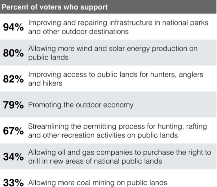
    Looking to potential actions the new Administration might undertake on public lands, voters in the Mountain West prioritized efforts that improve access, support the outdoor recreation economy and invest in renewable energy. Drilling for oil and gas or mining for coal on public lands was much less popular with voters.

    2017stateoftherockiespoll

    ā€œAs leadership changes hands in Washington D.C., and Congress votes in new budget rules removing any monetary value from public lands, voters in the Mountain West are sending a clear statement that they do not want to see a dramatic change of course when it comes to national public lands,ā€ said Dr. Walt Hecox, Professor Emeritus of Economics at Colorado College and founder of the State of the Rockies Project.

    Approval of the federal land management agencies was high as the new administration begins its tenure. 76 percent of respondents approved of the U.S. Forest Service, 82 percent approved of the National Park Service, 76 percent approved of the U.S. Fish and Wildlife Service, and 56 percent approved of the Bureau of Land Management.

    The poll asked voters about efforts to turn national public lands owned by all Americans over to state government control. The proposal remained unpopular, with 56 percent of respondents opposed. Strong majorities reject the proposal in every state sampled, with Utah as the lone exception, where voters remain narrowly divided.

    ā€œThe national political winds change direction every few years, but a passion for the outdoors and strong support for American public lands remain constant in the Mountain West,ā€ said Montana Governor Steve Bullock. ā€œPublic lands drive our economy and define our way of life in Montana and in surrounding states. We have too much to lose if we allow these national treasures to be put at risk.ā€

    The idea of removing existing national monument designations put in place over the past decade to protect public lands was a non-starter for Western voters. 80 percent of respondents supported keeping the monument designations in place compared to just 13 percent who wanted them removed.

    Support for national monuments was reflected at the local level when voters in Nevada and Utah were asked about two designations announced towards the end of the Obama Administration. In Nevada, 63 percent of respondents believed making Gold Butte a national monument was a good thing, compared to 13 percent who thought it was a bad idea. In Utah, 47 percent of respondents supported the designation of Bears Ears as a national monument, compared to 32 percent who opposed the decision.

    The poll showed strong support for cleaner forms of energy in Mountain West. Voters in six of the seven states surveyed pointed to solar, wind and renewable energy as their top choice when asked about the types of business and jobs they would like to encourage more of, outpacing the technology and healthcare industries.

    When it comes to oil and gas drilling on public lands, voters in the Mountain West continued to support a balanced approach. 50 percent said oil and gas drilling should continue in some areas while permanently protecting environmentally sensitive places. 35 percent believed oil and gas drilling on public lands should be strictly limited, while just 9 percent favored opening public lands up to more expansive drilling.

    A Bureau of Land Management rule to require oil and gas producers who operate on national public lands to use updated equipment and technology to prevent leaks of methane gas during the extraction process received widespread approval, with 81 percent of respondents wanting the policy to continue. Members of Congress are in the process of using the Congressional Review Act to eliminate the policy.

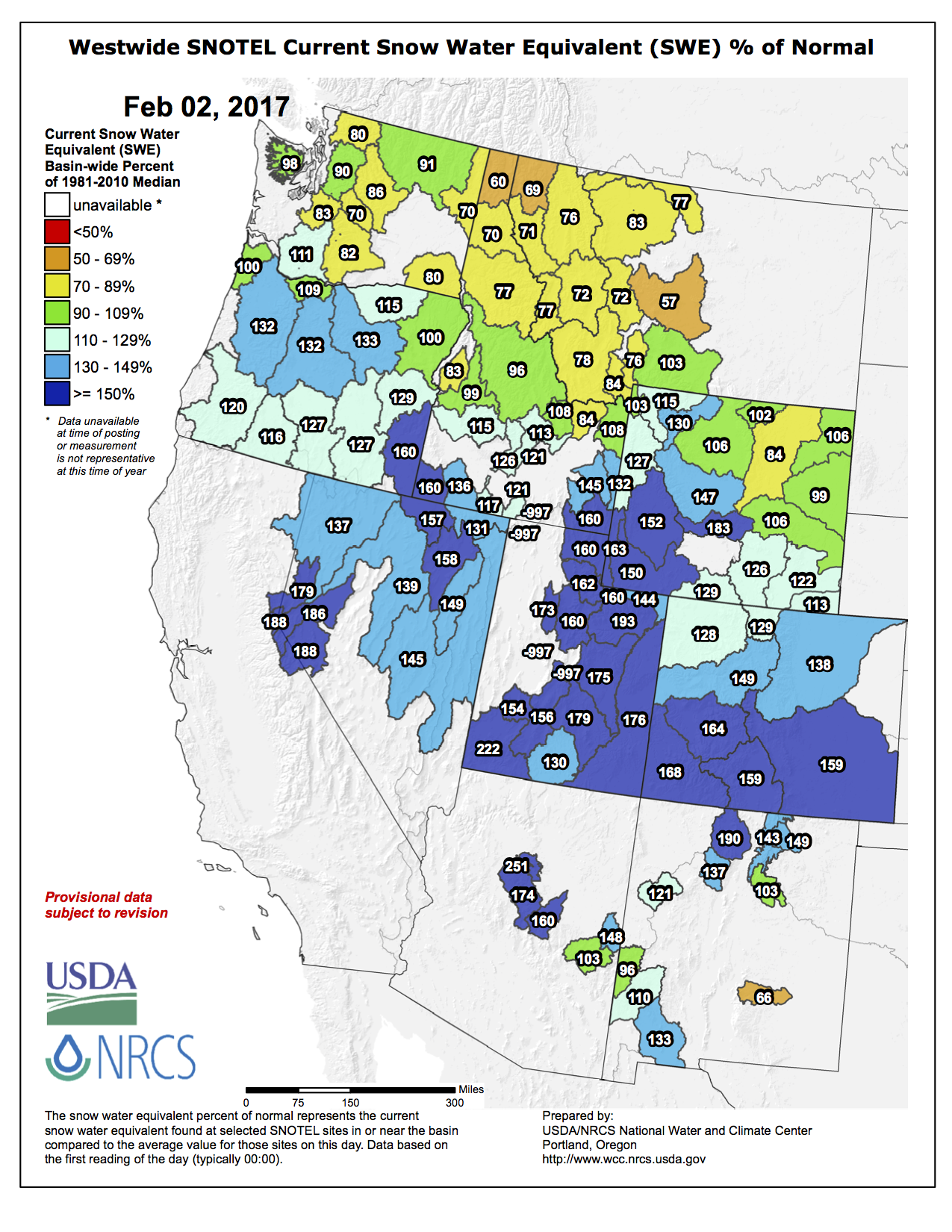
    The drought remained a top concern this year, as 80 percent of respondents said low levels of waters in rivers was a serious issue facing their state.

    This is the seventh consecutive year Colorado College has gauged the publicā€™s sentiment on public lands and conservation issues. The 2017 Colorado College Conservation in the West survey is a
    bipartisan poll conducted by Republican pollster Lori Weigel of Public Opinion Strategies and Democratic pollster Dave Metz of Fairbank, Maslin, Maullin, Metz & Associates.

    The poll surveyed 400 registered voters in each of seven Western states (AZ, CO, MT, NV, NM, UT & WY) for a total 2,800-person sample. The survey was conducted in late December 2016 and early January 2017 and has a margin of error of +/-2.74 percent nationwide and +/ -4.9 percent statewide. The full survey and individual state surveys are available on the Colorado College website.