North American River Otter: Live in coastal estuaries, rivers and even mountain streams. Sightings of river otters in the wild are rare because they prefer uninhabited areas with clean, clear water where food is abundant. Photo credit South Carolina Aquarium.
Colorado Parks and Wildlife biologists say that, after completing the reintroduction of about 120 young male and female otters 25 years ago, otters are multiplying with a statewide population now numbering in the hundreds.
The recovery here, mirrored in other states that reintroduced otters decades ago, stands out in the struggle for wildlife survival because biologists consider otters a “sentinel species” that is highly sensitive to pollution. It shows how a relatively modest state effort to keep an imperiled species off the federal endangered species list — the U.S. ecological equivalent of an emergency room — can lead to a comeback.
State-run reintroduction “has made a significant contribution to the conservation of river otters throughout the state of Colorado,” U.S. Fish and Wildlife Service biologist Leslie Ellwood said. “We’re now seeing river otters in streams and lakes where they had not been seen for the past 100 years.”
Although Colorado officials could not produce current population survey data or a peer-reviewed study, and while otters still are classified as “threatened” in the state, CPW tables indicate otters exist in 38 of 64 counties.
This means habitat suitable to otters in Colorado is relatively healthy, said Reid DeWalt, assistant director of wildlife and natural resources for the state. “CPW is vested in the long-term sustainability and balance of wildlife for future generations.”
[…]
Otters eat practically any animal that moves in riparian corridors: fish, frogs, snakes, turtles, crayfish, birds, salamanders. They grow to be 3- to 4-feet long, with males weighing about 25 pounds and females about 18 pounds. When predators such as coyotes lurk, otters have the ability to chase them away. And they energetically chase one another, sliding crazily along muddy banks — activities biologists describe as pure play for fun.
The prospect of a widening recovery has emerged as a success at a time when conservationists warn that scores of other plant and animal species are vanishing…
Starting in 1976, Colorado wildlife crews reintroduced river otters at five sites: Denver Water’s Cheesman Reservoir, Rocky Mountain National Park, and the Gunnison, Piedra and Dolores rivers. Similar efforts were happening elsewhere in the United States. The International Union for the Conservation of Nature estimates that more than 4,000 otters were reintroduced across 21 states.
Colorado kept up the reintroductions until 1991.
In 2003, members of the Colorado Wildlife Commission decided to down-list the status of the river otter to “threatened” from “endangered.” It’s still illegal to hunt them.
Colorado wildlife officials contend that the reintroduced otters are thriving with established populations around the Western Slope in waterways, including the Colorado, Green, Yampa, Dolores, Gunnison and San Miguel rivers, as well as tributaries in each basin.
Yet state monitoring is limited. CPW relies on Colorado residents to serve as eyes and ears — filling out and submitting forms giving details when they spot otters. Mink, beavers and muskrats share the same habitat as otters and, sometimes when seen swimming, are confused with otters.
U.S. Fish and Wildlife Service officials, charged with enforcing the federal Endangered Species Act, welcome state efforts to head off crises, said Marjorie Nelson, the USFWS regional chief of ecological services.
The good news: All of Larimer County’s biggest dams, including the dams at Horsetooth Reservoir, have emergency action plans designed to prepare authorities for emergencies like what happened in California this weekend.
And the bad: A small percentage of Colorado’s higher-hazard dams don’t have emergency plans. Failure could put human lives, environment and property at risk.
It’s a problem highlighted nationwide this week after the Oroville Dam, located about 75 miles north of Sacramento, suffered a potential failure of its emergency spillway. While the dam itself remained intact, erosion damage to the spillway raised the possibility of the structure failing and unleashing an uncontrolled torrent of water.
This situation is unlikely to occur at any of the Horsetooth Reservoir dams, according to officials from the Bureau of Reclamation and Northern Water. That’s partially because the structures underwent an $85 million renovation in the early 2000s. The modernization project included stripping the dams’ faces and adding a roughly 16-foot-thick filter of sand and gravel. Each of the dams was also bolstered for extra strength.
The lower risk here is also a question of magnitude, said Northern Water spokesman Brian Werner, who noted that the amount of water released through the Oroville Dam in 24 hours is more than Horsetooth Reservoir could hold at full capacity.
Perhaps most importantly, Horsetooth Reservoir’s relationship to its dams and water sources is different from Lake Oroville’s relationship with the Oroville Dam and the Feather River, which the dam impounds to form the lake. No river runs into Horsetooth Reservoir; gravity transports water there from other reservoirs in the Colorado-Big Thompson Project.
The Bureau of Reclamation in June 2016 finished a comprehensive review of Horsetooth Reservoir’s dams, which include the Horsetooth, Dixon Canyon, Soldier Canyon and Spring Canyon dams. All passed inspection.
Larimer County is home to 136 of Colorado’s 1,737 dams, according to 2013 data from the National Inventory of Dams. Twelve of those dams are very large…
Each of Larimer County’s high-volume dams received a satisfactory inspection rating at its most recent inspection, and none is used for flood control. All have emergency action plans, which include critical information like emergency contacts, details about the dam and an inundation map that shows where flooding will occur at different water levels…
Of Colorado’s 1,737 dams, about 25 percent, or 425, are considered “high hazard,” meaning one or more people are likely to die if the dam fails. About 96 percent of those dams have emergency action plans, significantly higher than the national rate of 69 percent.
An additional 19 percent of Colorado dams are considered a “significant hazard,” which means their failure would result in possible loss of human life and likely significant property or environmental destruction. About 92 percent of those dams have emergency action plans.
Inspection of Colorado dams falls to two agencies. The state’s dam safety division evaluates dams owned locally or by private and state agencies, and the Bureau of Reclamation monitors federally owned dams.
The scale of the erosion problem at the Oroville Dam site
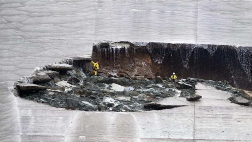
As the fairly desperate attempt continue to shore up the spillways at the Oroville Dam site, and to lower the water level ahead of the next rainstorm, better images are emerging of the scale of the problems on both spillways. If we start with the main spillway, which suffered the original erosion events last week, it is hard to appreciate the serious nature of the problems. However, this image (via the Sacramento Bee) from the weekend shows workers in the hole eroded in the main channel:-
The spillway hole at the Oroville Dam site, via the Sacramento Bee
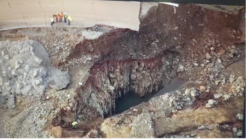
Of course the high flows down the spillway since then are likely to have exacerbated the problem significantly. Meanwhile, the headward erosion problem in the emergency spillway is now garnering most of the attention, primarily because of the potential for a major collapse. This image, from Hamodia, shows the nature of the erosion that has developed at multiple locations immediately down slope of the emergency spillway at the Oroville dam site:
Erosion below the emergency spillway at the Oroville Dam site, via Hamodia
The most serious problem appears to be a gully towards the bottom of the image, but there is also substantial amounts of erosion occurring on the other side too. The danger is of course that the these gullies will suffer headward erosion until they undermine the spillway lip. whereupon collapse may occur. One challenge is that the quality of the rock does not appear to be high, which accounts for the rapid erosion in both cases. This image, via Twitter, shows the nature of the bedrock with which the crews are dealing:-
The nature of the bedrock in the spillways at the Oroville Dam site, via Twitter
The challenges are substantial. Fortunately, as before, there is no threat to the dam itself.
From the Associated Press via The U.S. News & World Report:
HOW IMPORTANT IS LAKE OROVILLE?
Lake Oroville is the starting point for California’s State Water Project, which provides drinking water to 23 million of the state’s 39 million people and irrigates 750,000 acres of farms. It is the largest reservoir in the system, which was built in the 1960s and early 1970s to carry rain and snowpack from the Sierra Nevada mountains to parts of the San Francisco Bay area, Central Valley and Southern California.
Lake Oroville, completed in 1967, is a cornerstone of the system of 34 reservoirs, lakes and storage facilities, built and operated by California’s Department of Water Resources. It feeds into the Feather River — about 70 miles north of Sacramento — as well as the Sacramento River and the Sacramento-San Joaquin River Delta. From there it travels south on the 444-mile California Aqueduct.
Oroville’s storage capacity of 3.5 million acre-feet of water is enough to supply urban California for up to six months, said Peter Gleick, president emeritus of the Pacific Institute, a water research organization based in Oakland, California.
“The risk of losing Oroville is very, very low” he said. “The consequences would be catastrophic.”
WHAT ARE SPILLWAYS?
When reservoirs get too full, their operators release extra water down long channels, or spillways, designed to carry it downstream in a safe, controlled way.
Oroville Dam has a main concrete spillway that normally is used to release floodwaters into the Feather River downstream. A second spillway mainly made of earth serves as an emergency backup. It also was supposed to be able to handle high flows from the dam, but it had never been used before Saturday.
The force of water [released] from the lake has damaged both spillways.
WHAT CAUSED THE FLOOD THREAT?
After five years of drought, a wet winter has strained the system at Lake Oroville, which is receiving runoff from melting snow in the Sierra Nevada as well as from the latest in a series of heavy storms.
Dam operators noticed chunks of concrete in the main spillway on Feb. 7. When workers stopped releasing water to investigate…With the reservoir nearing the top of the 770-foot-high dam, dam operators were forced to keep using the main spillway despite increasing damage to it from the rushing water.
The dam reached capacity Saturday, sending water surging over the second, emergency spillway. Operators on Sunday noticed water was gouging a hole in the earthen emergency spillway as well. Fearing that the emergency spillway could fail and send torrents of water rushing downstream uncontrolled, authorities ordered the evacuation Sunday evening.
BESIDES OROVILLE, WHERE DOES CALIFORNIA GET ITS WATER?
The Central Valley Project, operated by the U.S. Bureau of Reclamation, irrigates more than 3 million acres of farms and provides enough drinking water for more than 1 million people. The system of 22 reservoirs was built from 1937 to the 1950s, extending about 400 miles from the Cascade Mountains near Redding to the Tehachapi Mountains near Bakersfield. It includes Shasta Lake, the only reservoir in California that’s larger than Oroville.
The Colorado River supplies 19 million urban dwellers in Southern California through a 242-mile aqueduct from Lake Havasu, Arizona, to the state’s coastal regions that was completed by Metropolitan Water District of Southern California in 1941. The Colorado also farms California’s Imperial Valley — a major source of the nation’s winter vegetables — through the 80-mile All-American Canal that hugs the state’s border with Mexico.
Other significant pieces of the state system include the Los Angeles Aqueduct, which carries water from Mono Lake to the city of Los Angeles, and the Hetch Hetchy reservoir in Yosemite National Park, which supplies the San Francisco Bay area.
Gov. Jerry Brown is asking the Trump administration for federal assistance in responding to a potential failure of a spillway at the Oroville Dam in Northern California.
In a letter to President Donald Trump released Monday, Brown asks for help for the three Northern California counties affected.
Brown says aid is needed to assist the 188,000 residents of Butte, Sutter and Yuba counties who were ordered to evacuate Sunday after concerns an emergency spillway could give way, unleashing a gush of water to downstream towns.
Brown has criticized Trump on many of his initiatives, but at a news conference Monday he lauded the president’s plan to invest $1 trillion on infrastructure.
The governor says California and Washington will work “in a constructive way” to repair failing infrastructure in the state…
The California Department of Water Resources says helicopters are dropping loads of rock on a hole at the lip of Oroville Dam’s emergency spillway.
Workers are hoisting giant white bags filled with rocks and at least two helicopters flying them and releasing them in the spillway’s erosion. Dump trucks full of boulders also are on their way to dump their cargo on the damaged spillway.
The barrier at the nation’s tallest dam is being repaired a day after authorities ordered mass evacuations for everyone living below the lake out of concerns the spillway could fail and send a 30-foot wall of water roaring downstream…
California’s U.S. senators are calling on President Donald Trump to approve a disaster declaration for the state in response to damage from recent storms.
Sens. Dianne Feinstein and Kamala Harris wrote in a letter Monday that the situation is especially dire downriver from Oroville Dam, where damage has threatened flooding and forced nearly 200,000 people to evacuate.
The senators are asking the president to provide $162.3 million in disaster assistance that California requested.
The lake behind Oroville Dam swelled significantly with this winter’s rains and the collapse of its damaged spillway threatens to flood downstream communities.
From the Associated Press (Olga R. Rodriguez and Don Thompson) via The Colorado Springs Gazette:
Nearly 200,000 people who were ordered to leave their homes out of fear that a spillway could collapse may not be able to return until the barrier at the nation’s tallest dam is repaired, a sheriff said Monday.
Butte County Sheriff Kory Honea gave no timetable for the work. Officials from the California Department of Water Resources were considering using helicopters to drop loads of rock on the eroded spillway at Lake Oroville, about 150 miles northeast of San Francisco.
Meanwhile, the water level behind the dam dropped, easing slightly the fears of a catastrophic spillway collapse. But with more rain expected later in the week, time was running short to fix the damage ahead of the storms.
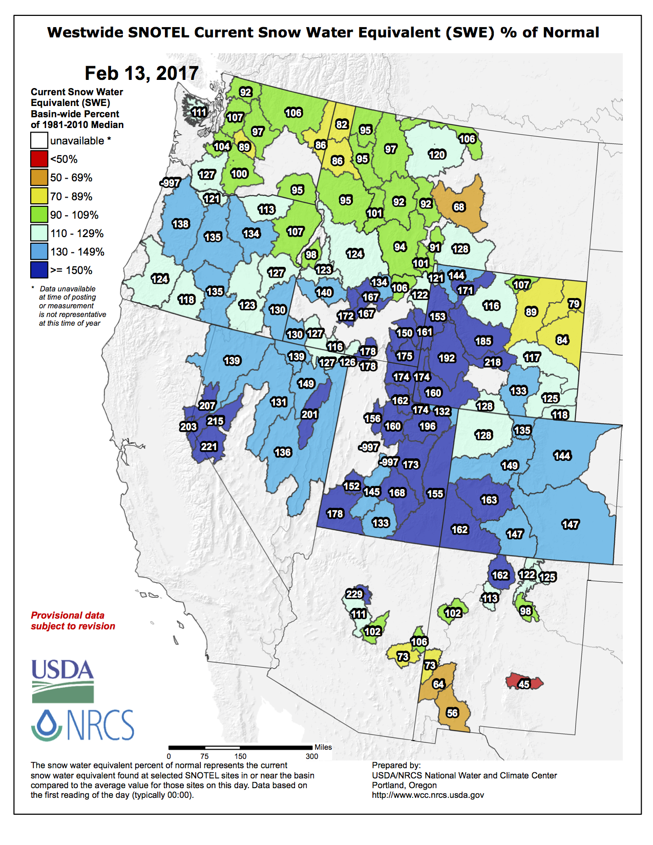
Westwide SNOTEL basin-filled map February 13, 2017 via the NRCS.
FromThe Las Cruces Sun-News (Diana Alba Soular) via The Albuquerque Journal:
Snowpack has continued to build in southern Colorado and northern New Mexico, which could lead to the best river water year in Doña Ana County since 2010.
The Elephant Butte Irrigation District board heard an update last week about the winter snowpack, which turns into spring snowmelt and feeds the Rio Grande each year. A major basin in southern Colorado is sitting at 151 percent of average for its snowpack, said Phil King, consultant water engineer for the district.
“The Upper Rio Grande is the big one; it’s well over average,” he told EBID board members.
A month ago, the same basin was at 143 percent of average.
Other basins in the southern Rocky Mountains that contribute to Rio Grande runoff also are above average, King said…
Snowpack in southern Colorado mountains affecting the Rio Grande was nearly 50 percent greater than a year ago, according to a Natural Resources Conservation Service report released Wednesday.
The district already has a small amount of water in storage in upstream reservoirs – Elephant Butte Lake and Caballo Reservoir – which is enough to issue farmers nearly a 6 acre-inches per acre allotment. The runoff will add to that.
Early federal forecasts are predicting a bumper spring runoff for the Rio Grande. But King said he’s more cautious in his outlook because hefty snowpack numbers haven’t translated into strong runoff in recent years. He said a shift in the environmental factors affecting runoff have thrown off forecasting models that worked in the past.
King said he’s preliminarily predicting EBID farmers could receive 18 to 24 acre-inches per acre of water for the season, a figure that includes both the 6 acre-inches already in storage and the possible new runoff.
If 24 acre-inches – or 2 acre-feet – is eventually allotted by the district, it would be the most since 2010, when EBID farmers received the same amount.
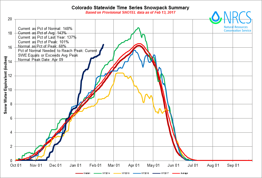
Statewide snowpack summary graph February 13, 2017 via the NRCS.
As of February 13, statewide snowpack was at a level normally seen around April 9 or 10. The dark blue line on the graph [above] shows the current average water content of roughly 16.3 inches.
Brian Domonkos, with the Colorado Snow Survey Program, says our current snowpack is the second highest since records began in 1986. Only 1997 was higher with an average water content of 18.4 inches.
With March and April being historically snowy months there’s a chance that the 30-year record set in 1997 could be challenged.