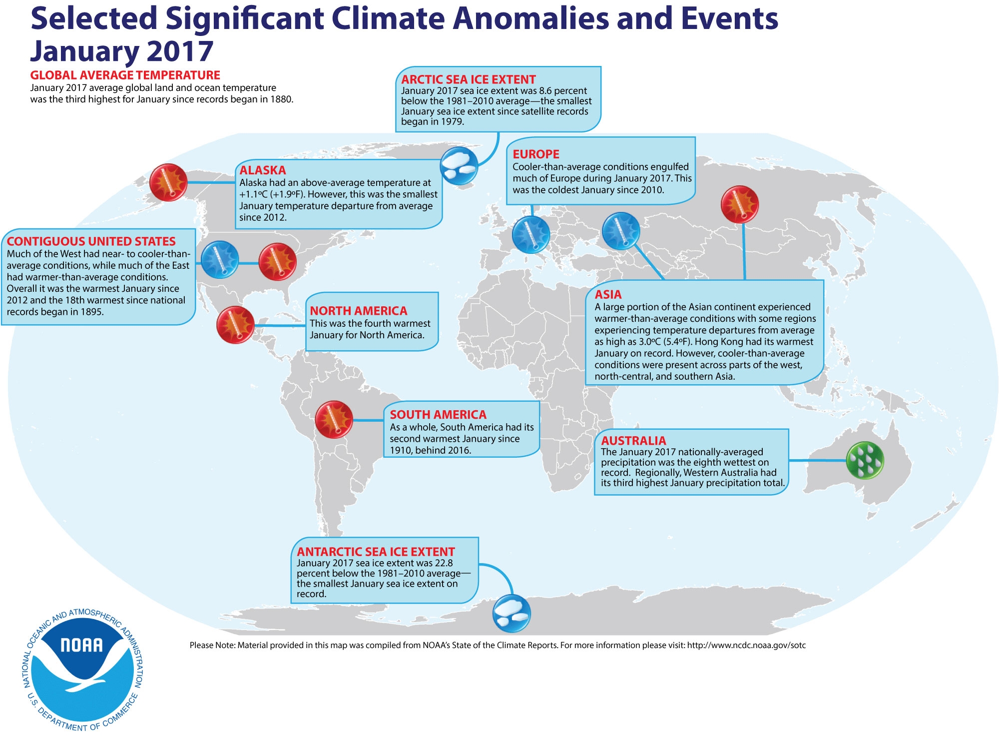
February 16, 2017 If the climate records of late 2016 were any indication, January 2017’s balmy global temperatures — and record-small polar ice extents — will come as no surprise.
January’s average global temperature was 1.58 degrees F above the 20th century average of 53.6 degrees, according to the analysis by scientists from NOAA’s National Centers for Environmental Information. This was the third highest for January in the 1880-2017 record, behind 2016 (highest) and 2007 (second highest).
More noteworthy findings for January included:
Record-low sea ice extent at the poles
The average Arctic sea ice extent was 8.6 percent below the 1981-2010 average for January, and the average Antarctic sea ice extent was 22.8 percent below the 1981-2010 average. For both regions this was the smallest January sea ice extent since the satellite record began in 1979.
Above-average snow cover in the Northern Hemisphere
The Northern Hemisphere snow cover extent was the sixth largest in the 51-year period of record. North America had its 13th largest and Eurasia had its seventh largest.
Warmer-than-average lands and oceans
The globally averaged sea surface temperature was the second highest January on record, 1.17 degree F above average.
The globally averaged land surface temperature was the third highest January on record, 2.77 degrees F above average.
Continents experienced temperature highs and lows
North America had its fourth warmest January on record; South America had its second; Asia tied as sixth; Oceania had its 13th; and Africa had its 21st. Cooler-than-average conditions engulfed much of Europe in January, which had its coldest winter since 2010.
Click here to go to the US Drought Monitor website. Here’s an excerpt:
Summary
During this U.S. Drought Monitor week, storms continued to impact the west, including parts of California, bringing more heavy precipitation to much of the region, as snow packs continued to increase and reservoirs continued to fill. Fortunately a respite from the storms came toward the latter half of the week. On the other side of the country, a strong low pressure system impacted much of the eastern United States, bringing heavy snowfall to central and northern New England on the 9th. Another nor’easter impacted the area on the 12th-13th. Meanwhile, an upper-level low over northern Mexico, along with a surface frontal boundary, resulted in rain and mountain snow from Arizona to western Texas. Precipitation spread across Texas to Oklahoma on the 12th-13th. Not all regions received rainfall. Much of the southeast continued to receive below-normal precipitation while record high temperatures spread across the south during the 11th-12th…
The Plains
Snowpack around 60 percent of normal as of early February led to the introduction of abnormally dry conditions (D0) in part of central Montana from northern Meager to south and central Fergus counties. In eastern Colorado, moderate drought conditions (D1) were extended to northwest Yuma County, northern Washington County, and southeast Logan County. This area has received below 50 percent of normal precipitation since the beginning of October, and recent weather has been hot and windy. The winter wheat also appears to be in poor condition. Additionally, abnormally dry (D0) conditions were expanded to the northern border of Colorado in Weld County…
The West
Storms continued to drop heavy precipitation over parts of California, leading to widespread improvements of the multi-year drought in the state, although some pockets have missed out on the precipitation and water restrictions remain due to low reservoir levels. A few large–scale improvements were made in central and southern California. Drought conditions improved in Monterey and eastern Santa Clara Counties. Western Monterey and most of Santa Clara County are now drought free. Improvements were also made across the San Joaquin Valley, with snowpack well above 100% in the Sierras. Reservoirs are being replenished across most regions. At the foot of the Sequoia National Forest, Lake Isabella’s water level increased 20 percent. Further south, drought conditions broadly improved across San Bernardino and southern Inyo counties. However, Death Valley remains in moderate drought (D1) as the area has received just 35% of its normal precipitation for the water year to-date…
Looking Ahead
The NWS WPC 7-Day Quantitative Precipitation Forecast (QPF) calls for much more heavy precipitation to impact the west, from Washington all the way to southern California, with an area in northwestern Washington forecast to receive as much as 10.8 inches of precipitation. Overall wide swaths are expected to receive well over two inches of rainfall. Rainfall may also impact southern Texas. Moving eastward, much of the southeast is forecast to see a quarter to a little over an inch of rain over the seven-day period. Once again, central and northern New England may see heavy moisture during the week, with the heaviest amounts projected over northern New Hampshire. The CPC 6–10 day outlooks call for a high probability of above-normal temperatures across the eastern two-thirds of the United States, and below-normal temperatures forecast to prevail in the west. Below-normal precipitation is forecast for a swath in the southwest covering Arizona, New Mexico, and central to western Texas while above-normal precipitation is expected most everywhere else in the contiguous U.S. Northern Alaska is also expected to receive above average precipitation and below-average temperatures during the period, while the southern tier is forecast to be warmer than average.
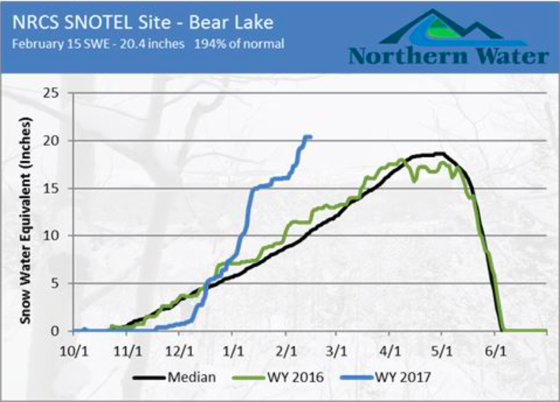
The Bear Lake SNOTEL (Big Thompson watershed) site’s normal peak is 18.6 inches of snow water equivalent. As of Feb. 15, the site was reporting 20.4 inches of SWE. This is above the normal peak, with two additional snow accumulation months to go.
Thank you, January. Numerous storms last month provided much-needed precipitation in Colorado’s mountains. As a result, all eight of the watersheds monitored by Northern Water currently have above-average snow water content, and the most probable streamflow forecasts are also well above average.
As of Feb. 14, statewide snowpack was 147 percent of normal. And the two major river basins Northern Water monitors for its forecasts, the Upper Colorado and South Platte basins, were at 147 and 142 percent of normal, respectively.
Beginning each February, Northern Water’s Water Resources Department releases monthly snowpack and streamflow forecasts. The forecasts provide:
Snow water content comparisons in the eight watersheds Northern Water monitors
April through July maximum, minimum and most probably streamflow forecasts
C-BT Project storage also remains above average for this time of year. On February 1, active storage in the project was 530,331 acre-feet, or 121 percent of normal.
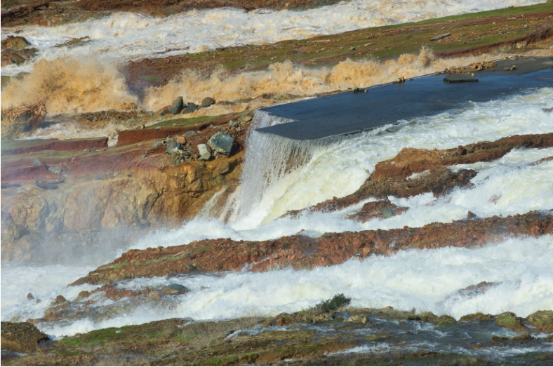
Water from the Oroville Dam auxiliary spillway has eroded the roadway just below the spillway. Photo courtesty of Kelly M. Grow/ California Department of Water Resources via @circleofblue.
Let’s not let a good crisis go to waste: Here are six important conversations that need to happen in the aftermath of problems at Oroville Dam in Northern California.
A critical question is whether the main spillway will be serviceable for the remainder of the winter. Dam managers must continue to release water down the damaged main spillway to maintain flood space behind the dam for coming storms and spring snowmelt. Bill Croyle, acting director of DWR, told the Sacramento Bee this past Sunday that his agency is not seeing further erosion of the main spillway at current flow levels of 100,000 cubic feet per second (cfs). Managers also shut down the turbines at the base of the dam that normally release up to 15,000 cfs because of downstream obstructions.
If another storm sends water into Oroville Lake faster than it can be released via the turbines and main spillway, then water could again over flow the concrete wall that forms the top of the emergency spillway. If the hillside beneath erodes further, this wall could collapse or be undermined, sending massive amounts of water downstream causing damaging, life-threatening floods.
Sacramento Bee has a concise recap of events here.
Can We Prevent These Types of Dam Crises in the Future?
It’s well-documented that the United States has chronically underfunded dams, levees, drinking water and wastewater infrastructure for years. The Association of State Dam Safety Officials estimates the cost of known needed repairs for the country’s 2,000 deficient, high-hazard dams at $21 billion. Drinking water, wastewater, waterways, ports and levees need repairs too. The American Society of Civil Engineers in a 2013 report put the unmet funding needs of our water infrastructure at $187 billion by 2020 (calculated in 2010 dollars).
Had the emergency spillway been lined with concrete, as was recommended in a motion filed by Friends of River, Sierra Club and South Yuba River Citizens League in 2005, it might have prevented the erosion that occurred this past weekend. In hindsight, it’s easy to see that this would have been a worthwhile investment compared to the cost of repairs, mass evacuations, and environmental impacts.
But the Oroville spillway crisis reveals another important question we haven’t been asking about our underfunded infrastructure. That is: How much money do we need to budget for upgrades that are becoming necessary as engineering standards improve and climate change imposes greater pressures on the system? We may be on the hook for even more money than we realize.
Where Are We Going to Get the Money to Repair the Spillways?
Preliminary estimates to repair just the main spillway are in the range of $100m-$200m, according to Bill Croyle at DWR. The State Water Contractors that get their water from the State Water Project will likely have to pay for at least part of the repairs, and they will pass the costs on to their ratepayers. Three more things to note.
First, these expenses are likely to cause increases in costs for ratepayers, some of whom are already struggling to pay their water bill. Second, we should expect a vigorous debate as to who else should help foot the bill. Should residents of the floodplain pay for a portion of the repairs, since they benefit from flood control? Should all California taxpayers chip in via allocations from the General Fund or Proposition 1 Bond monies? Third, these types of public works projects cannot be incentivized with tax deductions to private companies looking to build profitable projects, as the Trump administration has proposed.
Are We Going to See More Water Emergencies as the Climate Changes?
Scientific models project, and observational data corroborates, that California’s climate is becoming more variable, with hotter, longer droughts and bigger precipitation events. The state’s water system was designed for a climate we no longer have. More extreme events are going to test the limits of our infrastructure and reveal new weaknesses in the system.
What Does This Mean for the Feather River Ecosystem?
In general, storms are good for rivers. California’s river ecosystems are adapted for big pulses of water in the winter. But the Feather River, where Oroville Dam is located, has been heavily altered by people, so these storms play out differently than they did before the river was dammed and leveed.
Feather River Hatchery spawns about 30 percent of the fall-run Chinook salmon in the state, as well as large numbers of spring-run Chinook and steelhead trout. Spring-run Chinook and Central Valley steelhead trout are listed as threatened under the Endangered Species Act; fall-run Chinook are still an important species for commercial fishing. Hatchery staff relocated five million juvenile salmon to a nearby facility, and have rigged a system to bring in municipal water to support the 1 million steelhead still at the hatchery. If hatchery operations go awry, it could impact populations of these valuable species.
The Feather River itself is still an important spawning ground for natural salmon and steelhead. But levees mean the river is restricted to a narrow channel, where rapid flows scour out the nesting grounds. Meanwhile, influxes of sediment and debris are likely to damage spawning grounds in the short run.
The Oroville Dam and the levees downstream were built for the joint goals of water storage and flood prevention, but floods are healthy for both the river and the floodplain. Long term, California should be thinking about places where it can move levees and allow rivers to reconnect with their floodplains.
Looking Forward
Nobody wants to see people evacuated from their homes because of a potential natural disaster. The silver lining to a crisis is that it can generate political will to deal with unpleasant, chronic problems. The problems at Oroville Dam are linked to unresolved issues we have with funding our infrastructure, adapting to climate change and restoring natural ecosystems. Let’s move forward in ways that address the immediate emergency and the long-term problems.
The near-failure on Sunday evening of the auxiliary spillway at Oroville Dam and the ongoing emergency operations to contain flood waters in California’s second-largest reservoir and shore up its eroding outlet are a tale of caution for the nation’s aging dam fleet.
“I think it should give many people reason to step back and take a hard look at things, including California,” wrote Martin McCann, director of the National Performance of Dams Program at Stanford University, in an email to Circle of Blue.
The Oroville emergency is unfolding in a state with a dam safety program widely regarded as the nation’s strongest. McCann agreed that California’s efforts to prevent a partial collapse of Oroville’s auxiliary spillway should be a wakeup call for other states with less vigilant dam regulation. Alabama, for instance, has no state dam oversight at all.
Already the top spending state for dam safety, both in total dollars and inspectors per dam, California increased its program budget by six percent between 2014 and 2016, to $US 13.3 million. The Department of Water Resources’ Division of Safety of Dams has roughly one employee per 20 state-regulated dams. That is far greater than the national average of one employee per 200 dams, according to data from the Association of State Dam Safety Officials.
“California has had a strong dam safety program for many decades,” McCann said. “It’s well-funded, well-staffed, and they inspect regularly.”
Dam safety experts cite money as the most significant impediment to safer dams. Though California spends big on oversight, the cost of repairs has emerged as a factor in the Oroville emergency. Reporting from the Mercury News revealed that state and federal officials rejected an appeal from three environmental and civic groups in 2006 to line the auxiliary spillway with concrete. The groups were concerned that the topsoil on the hillside spillway would erode if it were ever used. February 11 was the first time that water flowed over the auxiliary spillway since the 770-ft-tall dam was completed in 1968. Use of the auxiliary spillway was necessary because of damage to the main spillway and inflows to the reservoir that nearly matched the flow of the Mississippi River at St. Louis. Officials had to evacuate as much water as quickly as possible.
Most of the more than 90,500 dams in the U.S. Army Corps’ national dam database, however, are not behemoths like Oroville. Most instead resemble Twenty-one Mile Dam, a 47-foot-tall earthen structure in Elko County, Nevada. Owned by Winecup Gamble Ranch, a 948,000-acre livestock operation, the dam burst on February 9 during heavy rain. Flood waters released by the dam chewed through 200 yards of Highway 233, which remains closed.
Two-thirds of U.S. dams are privately owned and often owners do not have funds for maintenance or repair, according to Lori Spragens, executive director of the Association of State Dam Safety Officials. Most U.S. dams are more than 50 years old and an unknown number are not built to current safety standards. The association estimates that $US 18.7 billion is needed to repair high-hazard, state-regulated dams. High-hazard dams could kill people if they failed…
The pressure on Oroville will not soon let up. The watershed above the dam is expected to get as much as eight inches of precipitation through February 21. Then in the spring, the massive snowpack, measuring twice the historical average in some spots, will melt. The California Nevada River Forecast Center estimates that water flows in the Feather River, which drains into Oroville, will peak on April 29.
All of which has state officials on constant alert. “We want to complete assessments, do corrective measures on the emergency spillway, and get it ready for potential future use here in the coming weeks or months,” said Bill Croyle, acting director of California Department of Water Resources.
Erosion below the emergency spillway at the Oroville Dam site, via Hamodia
The Pueblo County commissioners on Wednesday asked staff to file a motion to intervene in a lawsuit filed Nov. 9 in U.S. District Court in Denver by the Environmental Protection Agency and the Colorado Department of Public Health and Environment against Colorado Springs.
Pueblo County wants to join the case to protect its interest during the litigation.
“We did it primarily to make sure we have a seat at the table,” said Pueblo County Commission Chairman Terry Hart.
“It’s one of those issues that whenever any kind of conversation is going on that concerns Fountain Creek or the water volume or quality that’s in the creek, we feel it affects the citizens in our community.”
[…]
By intervening in the lawsuit Pueblo County hopes to:
Support the EPA and CDPHE in its regulatory mission.
Ensure that stormwater control infrastructure within Colorado Springs is properly operated and maintained.
Ensure that there are no conflicts or inconsistencies between the stormwater intergovernmental agreement recently entered by the county and Colorado Springs and any remedy, judgment or settlement entered in this case.
Require Colorado Springs to become, and then remain, compliant with the Clean Water Act, the Colorado Water Quality Control Act, stormwater regulations and the conditions of Colorado Springs’ MS4 permit, and protect against future violations.
Work with Colorado Springs to develop, implement and enforce its’ Stormwater Management Program as required by the MS4 permit.
Prohibit Colorado Springs from discharging stormwater that is not in compliance with its MS4 permit or its SMP.