Yes, unless the melting stops and precipitation returns. Click on a thumbnail graphic to view a gallery of snowpack data from the NRCS.


From The Fort Collins Coloradoan (Jacy Marmaduke):
After a healthy start to the snow season, the flakes just stopped falling after early January. Fort Collins has received about 5 inches of snow since our last big storm in January, and halfway through what’s usually the snowiest month of the year, we have received a trace of snow.
State climatologist Nolan Doesken calls this our “abbreviated winter.” And while it’s lovely to hike Horsetooth without a jacket in February, the warmth and dryness don’t bode well for regional drought, residential lawns and fruit trees that bud early during warm winters.
Fort Collins has received about 9 inches of precipitation in the last 12 months, compared to a normal amount of about 15 inches, rendering our moisture levels “really painfully low,” Doesken said.
The coming spring, which officially starts Monday, is our best shot at catching up, Doesken said. If spring storms don’t come through, it’s time to start worrying about worsening drought.
So what’s to blame for our lack of moisture? Blame it on the jet stream, that meandering wind ribbon that brings Northern Colorado much of its winter cold snaps and snowstorms.
In recent months, the jet stream has wriggled just north of our reach, bringing big snows to Wyoming and leaving Northern Colorado out to dry. South of the jet stream sits a pesky high pressure ridge that keeps conditions warmer and dryer than usual.
You can also blame this winter’s weirdness on climate change, according to Doesken.
“Normal temperatures have definitely risen,” Doesken said. “You’d expect every three to six years you’d have one year that was considerably below the long-term average, and we just haven’t been seeing any years like that.”
Weather data from this season is a bit deceptive because several short-lived cold snaps evened out average temperatures. February’s freak ice storm and early January’s intense cold snap and snowstorm made this winter look more average on paper than it felt for residents.
Oh, and don’t forget all the crazy wind we’ve seen lately. Northern Colorado has been collecting red flag days for weeks, with gusts of wind fueling grass fires and knocking trees into houses and cars.
Doesken argues the winds aren’t so crazy, although Northern Colorado wind data is admittedly sparse…
Back in Northern Colorado, mountain snowpack will probably save us from the worst-case scenario of regional drought paired with tepid water supply. A burst of big snows from mid-November to mid-January amped up mountain snowpack from about half of the average amount to nearly 160 percent of the average by Jan. 12. A recent dry and warm spell for the mountains has eaten into that abundant snowpack level, but we are still above average…
“We’re moving into our normal wetter season from the Front Range eastward,” Doesken said. “Will it arrive before we get more wind and heat? It’s always sort of a wait and see.”
From Steamboat Today (Tom Ross):
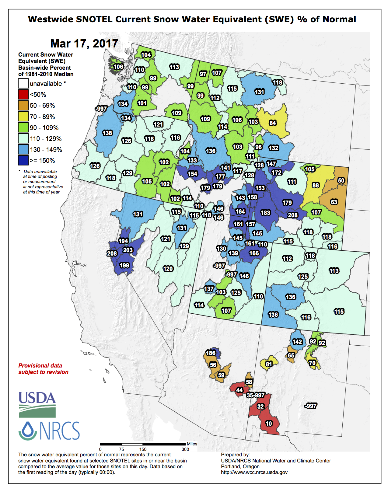
When Denver-based federal Snow Survey Supervisor Brian Domonkos, of the Natural Resources Conservation Service, released his March 1 water forecast, he noted that the water in the snowpack of the Yampa Basin was 115 percent of median for the date. And, the water currently stored in Stagecoach Reservoir, just east of Oak Creek, and in Yamcolo Reservoir, on the edge of the Flat Tops south of Yampa, is more than 120 percent of average.
But Kevin McBride, general manager of the Upper Yampa Water Conservancy, which owns the two reservoirs, said March 9 his office is looking at the snowpack on a weekly basis — and sometimes, on a daily basis, this time of year — and tweaking how much water it is releasing from Stagecoach. It’s all about balancing releases of water with the projected inflow of melting snow in order to get to the finish line with a reservoir that’s full, but not too full.
“It’s hard to outthink the weather, but so far, it look pretty good,” McBride said March 9. “We’re making full (hydroelectric) power right now at Stagecoach and bringing it down a little bit. It’s carbon-neutral power, and we’d like to make as much as we can.”
McBride said he’s less interested in reports of average reservoir storage, because those numbers can be skewed by either record low or record high years. He and District Engineer Andy Rossi meet with the dam managers every Monday to strategize.
With the reservoir level at Stagecoach almost 125 percent of average going into the second week of March, one might think dam managers have it made. But McBride doesn’t take anything for granted. After heavy snowfall in both December and January, the upper Yampa Valley has seen meager snow in February, continuing through the first week in March. Spring snowmelt can peak suddenly, catching dam operators by surprise, and summer precipitation could falter, causing the level of the reservoir to slip as irrigators seek to flood their hayfields.”
“On March 1, we start tracking the river and every drop that goes in or out of Stagecoach,” McBride said. It’s also “the beginning of our administrative year for water rights.”
Upper Yampa keeps close track of the same snow-measuring sites (referred to as snotels) the Conservation Service manages but customizes the data for its needs. Bullish snowpack measurements in early March don’t necessarily convert to a smooth runoff for dam managers. McBride observed that, while the snotels at higher elevations are reflecting above average snowpack, “town looks kind of dry.” That leads him to wonder if low elevation runoff might occur earlier than usual this season, affecting inflow at the dam later in spring.
“Last year, we had pretty good snowpack, but the (July/August) monsoons weren’t very good,” McBride said. “We want to be 90 percent sure we’re going to fill.”
On the other hand, McBride said, the ideal scenario would be if the snowpack that feeds Stagecoach came off “nice and slow, and we can control it.”
McBride hopes against a heavy rain-on-snow event that could bring the snowpack off faster than dam managers can keep up with. Were that to happen while ice still covers the reservoir, there’s a chance chunks of ice could be washed over the spillway and potentially cause damage.
Here’s the Westwide SNOTEL basin-filled map for March 17, 2017.