#Drought to persist in E. #Colorado, development likely over the central plains

Drought forecast March 2017 via the Climate Prediction Center.

Click here to go to the US Drought Monitor website. Here’s an excerpt:

Summary

Several weather systems traversed the contiguous U.S. (CONUS) in the fast-moving upper-level flow during this U.S. Drought Monitor (USDM) week. Upper-level troughs, surface fronts, and surface low pressure systems brought above-normal precipitation to parts of the Southwest, parts of the Pacific Northwest to Great Lakes, and parts of the Southeast, Upper Ohio Valley, and Northeast. But the speed and tracks of the weather systems left much of California and other parts of the West, most of the Central to Southern Plains, parts of the Southeast and Northeast, much of the Mid-Mississippi Valley, and Mid-Atlantic coast drier than normal. Temperatures averaged cooler than normal in the West under the influence of the troughs, while the dominance of ridging east of the Rockies resulted in above-normal temperatures. As noted by the U.S. Department of Agriculture (USDA), the persistence of the unseasonably warm weather east of the Rockies has ushered winter wheat out of dormancy up to a month ahead of normal. The warm temperatures and unusually early green up have increased evapotranspiration and heightened the need for soil moisture in areas wrestling with winter-time drought, at a time when crop-water demands are typically minimal. As reported by the National Weather Service, vegetation has responded rapidly to the unusually warm temperatures, with flowers and trees blooming or in full bloom across east-central Georgia and central South Carolina. Drought conditions continued to improve in California, as the hydrologic systems responded to the precipitation of recent weeks and months, and in the Northeast. Drought and abnormally dry conditions expanded from the Southern Plains and Midwest to the Southeast and Mid-Atlantic coast, reflecting precipitation shortages that have developed over the last one to three months as well as, in the Southeast, worsening hydrological conditions and long-term dryness…

Central to Northern Plains

Bands of precipitation fell across the Central to Northern Plains. Much of Kansas and parts of the Dakotas received a tenth of an inch or less of precipitation, while a snowstorm dropped 0.3-1.0 inch of precipitation across parts of Nebraska and southwest South Dakota. D1 expanded across eastern Kansas, while D0-D1 contracted in northwest Nebraska and western South Dakota. According to February 27 USDA reports, 56% of the subsoil and 55% of the topsoil in Kansas, and 30% of the subsoil and 25% of the topsoil in Nebraska, were short to very short of moisture, while 21% of the winter wheat in Kansas was in poor to very poor condition…

California

Two or more inches of precipitation fell across parts of the northern California coast, the Sierra Nevada, and San Diego County regions, while less than an inch was recorded in other areas. The typical interior rainshadow areas had less than half an inch of precipitation. Drought improvement occurred in three regions.

The D0-L in the San Joaquin Valley was removed due to improving hydrological (aquifer) conditions. There are two types of aquifers: confined and unconfined. Unconfined aquifers are characterized by a geology where water can seep into the aquifer from the ground surface directly above. Confined aquifers have a geology in which an impermeable layer of dirt or rock exists above the aquifer which prevents water from seeping into it from the ground surface directly above. Confined aquifers are recharged by water seeping into them from farther away where the impermeable layer doesn’t exist. Most of the USGS well groundwater stations in the San Joaquin Valley were showing significant recharge occurring, while those that were still quite low were probably confined aquifers which may take months or years to recharge.

D1 was pulled back along the Coastal Range to Santa Barbara County. The lake levels of the reservoirs in Santa Barbara and Ventura Counties continued to rise but, since the rains let up, they were not rising as quickly. Lake Cachuma’s reservoir was at 87,466 acre-feet on February 26, which equates to 45.2% of capacity versus 42.4% a week ago; Lake Casitas was at 43% compared to last week’s 42.3%; and Lake Piru was at 33.7% versus last week’s 31.7%. D2 was kept in place in this region to reflect the continued low, but recovering, reservoirs. However, the recent rains have not improved the situation on the offshore islands. With below-normal precipitation this week and continued groundwater shortages, D2 was added to Catalina Island.

Rain during the last day of this USDM week gave southern California and southwest Arizona a good soaking, with rainfall amounts 0.5-2.0 inches over parts of Arizona and over 5 inches over parts of San Diego County in California. In the mountains of San Diego County, Palomar Observatory reported 9.04 inches of precipitation. D0-D1 was pulled back one category in San Bernadino, Riverside, and San Diego counties, and the adjacent D2 was trimmed a bit. The rain should result in rapid responses in local reservoirs. The San Diego River reached 14.2 feet, which is the third highest stage ever and slightly higher than December 2010 and 1980…

Rest of the West

One to 4 inches of precipitation fell across coastal Washington and Oregon and parts of the Northern to Central Rockies, the Great Basin, and Arizona. Less than an inch of precipitation fell across other parts of the West, with some areas receiving a tenth of an inch or less. D1 was deleted and D0 contracted in eastern Oregon and western Montana to better reflect precipitation and snowpack conditions. D0-D1 was trimmed in southwest Arizona and D0 pulled back in east-central Montana. D0 was added over the southwest mountains of Montana to reflect low snowpack water content (SWE) and subnormal precipitation at the 7-day to 3-month time scales, and D0 was expanded over northeast New Mexico to better reflect soil moisture and streamflow conditions…

Looking Ahead

In the 2 days since the Tuesday morning cutoff time of this week’s USDM, a frontal system dropped 1-2 inches of rain, and locally more, across parts of the Ohio Valley D0 area, with half an inch or more falling across parts of the Southeast. For March 2-9, 3-5 inches of precipitation, and locally more, is forecast for north coastal California to western Washington; 1-2 inches over parts of the Northern Rockies; and a tenth of an inch or more across the rest of the Northwest into the Great Basin. Precipitation is expected across parts of the Southern Plains to Southeast, Northern Plains to Great Lakes, and along the Eastern Seaboard, with amounts ranging from a few tenths of an inch across most of these regions, to an inch or two across southern Texas, the Gulf Coast, and northern Great Lakes. Most of the Southwest into the Central Plains should be dry. Above-normal temperatures are expected for most of the CONUS, with the greatest departures in the Central Plains, while below-normal temperatures may linger in the Pacific Northwest. Odds favor the temperature anomaly pattern persisting through March 10-15, with cooler-than-normal temperatures expected for Alaska. March 10-15 projections favor a continuation of the precipitation anomaly pattern with below-normal precipitation from the Southwest to Central Plains and along the Gulf of Mexico coast to Mid-Atlantic States, with above-normal precipitation favored for the rest of the CONUS. Odds favor drier-than-normal weather in southern Alaska and wetter-than-normal conditions in northern Alaska.

Click on a thumbnail graphic to view a gallery of drought data from the US Drought Monitor.

Aspinall Unit Spring streamflow forecasts

Aspinall Unit
Aspinall Unit

From email from Reclamation (Erik Knight):

The February 15th forecast for the April – July unregulated inflow volume to Blue Mesa Reservoir is 970,000 acre-feet. This is 144% of the 30 year average. Snowpack in the Upper Gunnison Basin is currently 166% of average. Blue Mesa Reservoir current content is 576,000 acre-feet which is 69% of full. Current elevation is 7489.3 ft. Maximum content at Blue Mesa Reservoir is 829,500 acre-feet at an elevation of 7519.4 ft.

Black Canyon Water Right

The peak flow and shoulder flow components of the Black Canyon Water Right will be determined by the May 1 forecast of the April – July unregulated inflow volume to Blue Mesa Reservoir. If the May 1 forecast is equal to the current forecast of 970,000 acre-feet of runoff volume, the peak flow target will be equal to 7,158 cfs for a duration of 24 hours. The shoulder flow target will be 966 cfs, for the period between May 1 and July 25. The point of measurement of flows to satisfy the Black Canyon Water Right is the Gunnison River below Gunnison Tunnel streamgage at the upstream boundary of Black Canyon of the Gunnison National Park.

Aspinall Unit Operations ROD

Pursuant to the Aspinall Unit Operations Record of Decision (ROD), the peak flow and duration flow targets in the lower Gunnison River, as measured at the Whitewater gage, will be determined by the forecast of the April – July unregulated inflow volume to Blue Mesa Reservoir and the hydrologic year type. At the time of the spring operation, if the forecast is equal to the current forecast of 970,000 acre-feet of runoff volume, the hydrologic year type will be set as Moderately Wet. Under a Moderately Wet year the peak flow target will be 14,350 cfs and the duration target at this flow will be 10 days. The duration target for the half bankfull flow of 8,070 cfs will be 40 days.

Projected Spring Operations

During spring operations, releases from the Aspinall Unit will be made in an attempt to match the peak flow of the North Fork of the Gunnison River to maximize the potential of meeting the desired peak at the Whitewater gage, while simultaneously meeting the Black Canyon Water Right peak flow amount. The magnitude of release necessary to meet the desired peak at the Whitewater gage will be dependent on the flow contribution from the North Fork of the Gunnison River and other tributaries downstream from the Aspinall Unit. Current projections for spring peak operations show that flows in the Gunnison River through the Black Canyon could be over 8,000 cfs for 10 days in order to achieve the desired peak flow and duration at Whitewater. If actual flows on the North Fork of the Gunnison River are less than currently projected, flows through the Black Canyon could be even higher. With this runoff forecast and corresponding downstream targets, Blue Mesa Reservoir is currently projected to fill to an elevation of around 7515 feet with an approximate peak content of 790,000 acre-feet.

#Snowpack news: SW basins = 154% of normal (best in #Colorado), Yampa/White = 122% (lowest)

Click on a thumbnail graphic to view a gallery of snowpack data from the NRCS.

From Las Vegas Now (Katie Boer):

Nevada is still considered to be in a drought, but the accumulation in snowpacks has experts hopeful about the health of Lake Mead. However, the state’s not out of the clear.

For years the lower Colorado River Basin has been in a drought impacting Nevada and California, but the snowfall in the Rocky Mountains this season has been significant causing much of the Great Basin to be well above average.

The snowpack in the Rockies is up 150 percent to 200 percent above normal, so that will be a direct impact on runoff that eventually feeds directly into water levels at Lake Mead.

“We were just up at Kyle Lake yesterday, and thats a long time site for us. It’s a snow course that we measured back in 1940, and the amount of water in the snowpack yesterday was within two-tenths of the record high for that time of year,” said Troy Brosten, assistant snow surveyor supervisor for the Natural Resources Conservation Service for the USDA.

According to Brosten, the heavy snowpack, once it starts to melt, will flow downstream into the upper Colorado River, eventually hitting the lower Colorado River Basin before arriving at Lake Mead.

“With the snowpack accumulation that we have, we will see improvements in the drought situations,” Brosten said.

“Right now the Colorado River, the lower parts are fairly stable, and we’re seeing the levels of Lake Mead rise just a little bit,” according to Rose Davis, Bureau of Reclamation, lower Colorado region…

“It’s looking good right now,” Davis said. “We’re looking good for an in-flow from the upper basin this year of about 9 million acre-feet. We’re getting a good snow pack. It’s not going to undo 16 years of drought, but it is going to maintain our lake levels and perhaps let them come up a little bit.”

But regardless of this year’s heavy snowpack, Davis says “it’s a very important concept for to remember that nobody’s out of drought.” “I mean regardless of what you’re seeing on the flooding in California and other places — one year doesn’t undo drought,” Davis said.

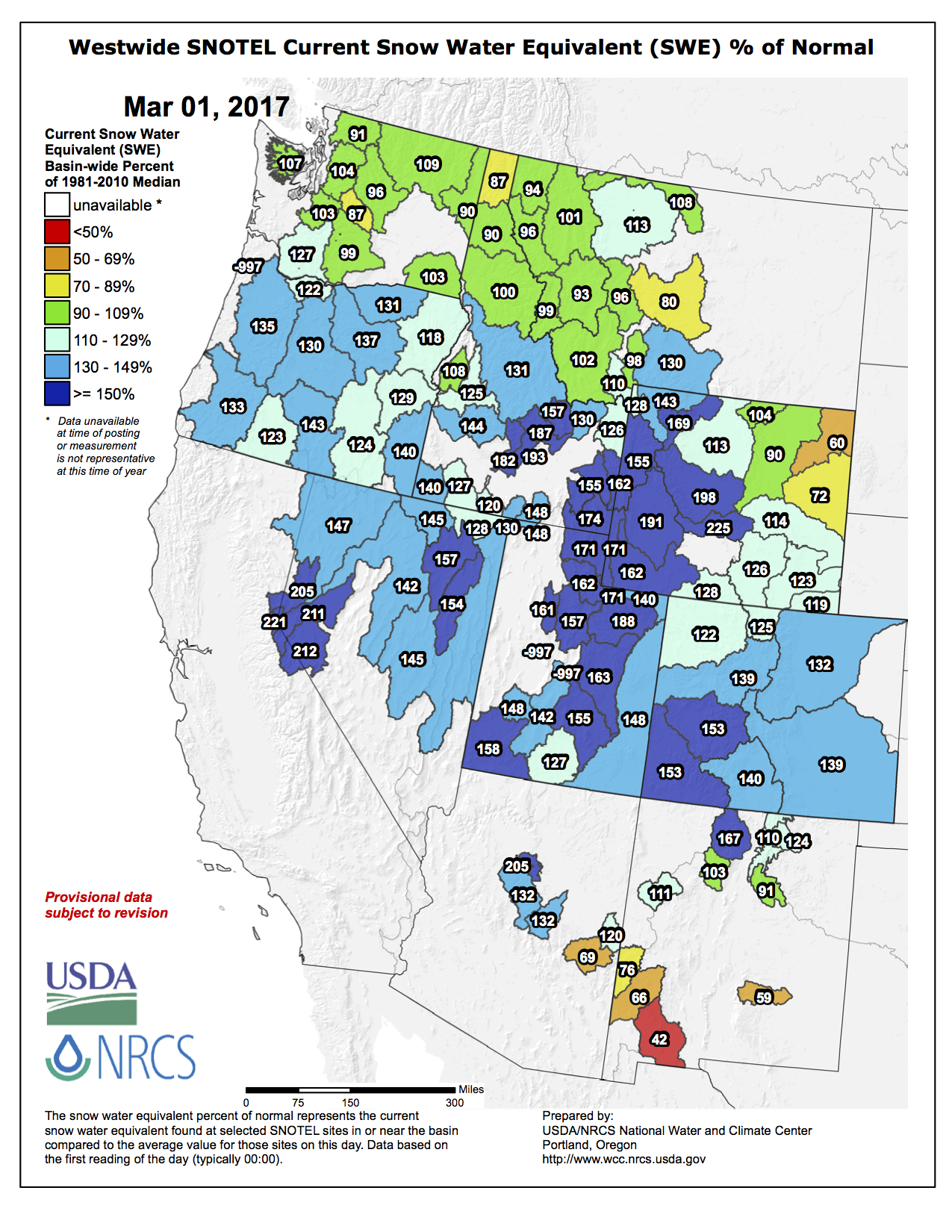
And here’s the Westwide SNOTES basin-filled map from the NRCS.

Westwide SNOTEL basin-filled map March 1, 2017 via the NRCS.

The February 2017 “Headwaters Pulse” is hot off the presses from @CFWEwater

screen-shot-2017-03-02-at-7-16-48-am

Click here to read the newsletter. Here’s an excerpt:

The Rural Water Conundrum

Roughly 20 percent of Colorado citizens rely heavily on groundwater for their drinking water supply. Many live in small communities: 98 percent of Colorado’s water systems serve communities smaller than 10,000 people. For small, rural water providers, limiting the risk of chronic health conditions ranging from kidney and liver disease to cancer means contending with a long list of federally regulated contaminants. Emerging and unregulated contaminants pose additional challenges. As rural communities work to reduce health risks, they also struggle to spread the costs of water testing and treatment over small populations, while keeping up with changing regulations and the evolving science of water pollution.

Meanwhile, private well owners remain exempt from any water quality regulations, but bear the weighty responsibility of essentially operating their own personal utilities by constructing their own wells and testing and treating drinking water. They count on state and federal groundwater laws to keep their water sources free of some pollutants, but ensuring clean water means paying for water testing and treatment while keeping accurate maintenance records. And yet, many well owners test their drinking water less frequently than state health officials recommend, and high costs are partly to blame. Some groundwater experts believe state government should do more to require or subsidize private well testing, but at least for now, relying on a private well means taking your family’s health into your own hands.

Read more about rural water health challenges by checking out this full article by Nelson Harvey. Find more information on public health and water in the latest issue of Headwaters magazine.

Senate confirms Zinke as Interior Secretary

Top 10 sources of plastic pollution in our oceans

Top 10 sources of plastic pollution in our oceans.

Ryan Zinke confirmed to lead @Interior

From The High Country News (Ben Long):

Ryan Zinke, who has served fewer than two terms in Congress, remains a relatively unknown figure in the world of natural resource politics. Whenever he has entered a national debate on cable news, it has been to make hawkish remarks on national security issues, touting his credentials as a former Navy SEAL.

But the Department of Interior‘s responsibilities lie within America’s boundaries, and especially in the West. Of the 640 million acres of federal public land in the United States, 500 million acres are under the purview of Interior. It’s a heady portfolio that includes national parks, national wildlife refuges, Bureau of Land Management lands and some national monuments. Interior also includes the Bureau of Indian Affairs, the U.S. Fish and Wildlife Service and the Bureau of Reclamation.

Zinke’s record on natural resources issues appears to be somewhat contradictory. When he issued a news release accepting the nomination to lead the Department of the Interior, he vowed to follow in the footsteps of Theodore Roosevelt. Indeed, since his first run at the state Legislature in Montana, he has often invoked the memory of that conservation icon.

Yet many environmental groups greeted his nomination for Interior boss with dismay, citing his congressional approval rating of only 3 percent from the national League of Conservation Voters. There’s also his tight connection to the coal and fossil fuel industries.

Sportsmen’s groups were warmer, noting that Zinke hunts and fishes and has at times stood up against some Republican leaders. He is against the sale of public lands and supports the Land and Water Conservation Fund.

Understanding a few key facts about Zinke may provide context as to how he will run the Interior Department:

Zinke is a coal-promoting politician from a coal-producing state.
He waxes nostalgic about the good old days of the Western timber industry and pushes for more logging on national forests.
At the same time, Zinke appears to understand how protected wild lands such as Glacier National Park and the Bob Marshall Wilderness contribute both to the economic vitality and the quality of life in small communities.
You can count on Zinke to push for the delisting of species under the Endangered Species Act, particularly the grizzly bear. In Whitefish, grizzlies act like super-size raccoons and routinely raid garbage cans.

But here’s the dilemma: Trump, and now by extension, Zinke, made a lot of promises to rural voters. They expect to see jobs coming back to loggers, sawmills and coal fields in rural America. Once regulations get purged, they were assured, America will be great again — at least according to their idea of greatness.

Trouble is, those jobs are gone for reasons that are a lot more complicated than overbearing regulations. It’s magical thinking to imagine that Trump or his Interior secretary can or will bring them back. You don’t get very far driving into the future when you’re looking in the rear-view mirror.

Zinke is setting a high standard for himself. Theodore Roosevelt loved science and constantly embraced new ideas. He spoke out vigorously against industries that, in his words, were out to “skin” the American landscape.

Yes, he loved the vigorous outdoor life and he delighted in his battleships, but he was also a scholar with a vision for America. TR paid a devastating political price for his principles in his lifetime. He was abandoned by the Republican Party, though his face later was carved on a mountain, a few decades after his death.

Here’s a statement from The Wilderness Society:

Statement from Jamie Williams, March 1, 2017 on Ryan Zinke confirmation as Secretary of the Interior.

“We expect Secretary Zinke to protect America’s natural heritage with the same sense of dedication and duty that he brought to his service to the nation as a Navy Seal,” said Wilderness Society President Jamie Williams.

“We will seek every opportunity to work with Secretary Zinke on issues that affect the public lands and waters that are owned by all Americans. But we will work just as hard to hold the Secretary accountable to his own promise to uphold the conservation ethic of Theodore Roosevelt and fight tirelessly for careful conservation and stewardship of those lands. The Secretary of the Interior must be a strong defender of our national wilderness areas, parks and wildlife refuges while also protecting sacred sites and places of cultural importance.”

Summitville Superfund scores $1 million @EPA grant

Summitville Mine superfund site

From CBS Denver (Blair Miller):

The Summitville Mine, located in Rio Grande County, has been under the purview of the EPA and Colorado Department of Public Health and Environment since 1992…

Construction on a hydroelectric power system at the site got underway in 2008, and $17 million in American Reinvestment and Recovery Act funds received in 2009 helped the completion of the water treatment plant at the site.

The $1 million in new Superfund grant money will go toward continuing water treatment at the site.

From The Denver Post (Bruce Finley):

In a statement announcing the grant, Colorado’s Republican U.S. Sen. Cory Gardner called the funding “critical to the continued clean-up at the Summitville Mine,” adding that he is “committed to ensuring Colorado receives the proper support from the federal government to make sure Colorado’s pristine environment is cared for.”

[…]

The EPA took over the site in 1992, when the mine operator went bankrupt and Colorado officials could not handle the disaster. Mine pollution had killed fish in a 17-mile stretch of the Alamosa River and ruined at least a square mile of soil.

There were five small water-treatment plants at the site. A couple were closed. Others were consolidated into a system that could clean 1,000 gallons per minute. That system later was deemed inadequate, leading to construction of a facility that could handle 1,600 gallons a minute of acidic, metals-laced mine drainage.

The Superfund cleanup still is not complete. Colorado officials in a 2014 report to lawmakers estimated the state’s share of water-treatment and other costs over 25 years will be $74 million…

Superfund cleanup work at some mines has stalled due to technical difficulty, lack of political will and scarce funds. For example, no work has been done for years in Colorado at the collapsing Nelson Tunnel above Creede, where millions of gallons of some of the West’s worst unchecked acid mine drainage contaminates headwaters of the Rio Grande River.

#Colorado Springs: Mayor Suthers’ report card 2 years in

Colorado Springs with the Front Range in background. Photo credit Wikipedia.

From The Colorado Springs Independent (Pam Zubeck):

Usually curt and to the point, Suthers on this day stretches what was scheduled as a 30-minute interview into a full hour. Perhaps he wants to bask in his achievements — persuading voters to approve a $250-million, five-year sales tax increase for roads; creating a $460-million, 20-year agreement with Pueblo County to fund the city’s drainage needs, and subduing a once-rocky relationship between Council and the mayor’s office.

But Suthers is too pragmatic to rest on his laurels for long. While he talks in endearing terms about his hometown of Colorado Springs…

What is your long game on flood control, and what role will City Council play?

First of all, it’s more than flood control. Stormwater is both flood mitigation and water quality. The federal part of this case is all about water quality. The end game is to get a stormwater program that does right by the citizens of Colorado Springs and also meets all legal muster. And right now, the outstanding legal issue is with the federal and state government — the Environmental Protection Agency and the Colorado Department of Public Health and Environment.

My goal is to hopefully reach a resolution with them and then assess whether there’s any more money involved than the intergovernmental agreement calls for. And then at some point, with the cooperation of Council, go to voters with a long-term solution to stormwater. Absent a dedicated revenue stream, that [$460 million for the agreement with Pueblo] is going to come from the general fund. That will put a lot of pressure on the general fund.

So the long-term goal, hopefully with the assistance of Council, and I don’t know how we would pull it off without Council, is to go to the voters. That would provide a funding stream for stormwater and allow us to free up some general fund money for some other obligations I see coming down the pike.

Notably, we, I think in the next five to 10 years, have to significantly increase the size of the police department, put more officers on the street…

With Donald Trump in the White House, any chance there might be a settlement or dismissal of the [EPA and CDPHE lawsuit]?

Haven’t heard that at all. We had the first court hearing last week. We recommended going to a third-party mediator, which we think that’s in our interest, and the federal government rejected that. We think we have a great case to show for all the alleged sins of the past. We’re moving forward, and I’ll stack our stormwater program and commitments up to any city in Colorado, but [the lawsuit] is going forward.

#Colorado Springs councillors OK @CSUtilities water sales to Security

Widefield aquifer via the Colorado Water Institute.

From KKTV.com:

On Tuesday afternoon, Colorado Springs City Council voted to help their neighbors deal with [pollution of the Widefield Aquifer]. They voted unanimously on the agenda item that will allow Colorado Springs Utilities to sell their water to Security Water District. The resolution goes into effect immediately.

It’s a short term deal – just up to three years as of now, but Springs Utilities says the have more than enough resources to help.

Executive order issued for review of the @EPA ‘Waters of the US’ rule

Evening clouds along the Yampa River in northwestern Colorado.

From The Denver Post (Bruce Finley):

President Donald Trump’s promised overhaul of environmental rules gained momentum Tuesday as he ordered a review and possible rollback of protections for streams and wetlands – igniting opposition from conservation groups.

The Senate meanwhile is poised to vote on rolling back two other rules passed by the Obama administration to protect public lands and air quality.

Trump’s executive order targets the EPA’s “Waters of the United States” rule, finalized in 2015, that reinterpreted the Clean Water Act to extend federal protection to small and seasonal waterways. These are critical for water supplies in water-scarce regions of the West.

EPA officials have said the rule will have the greatest impact in states such as Colorado where protection for small and seasonal water previously was uncertain. In Colorado, 68 percent of streams are seasonal.

The EPA insisted the rule wouldn’t get in the way of agriculture or require new permits and that the benefit was giving federal officials power to crack down on polluters.

But some Colorado farmers, a national coalition of industry groups, developers, and fertilizer and pesticide makers have fought the rule. They said it could lead to EPA enforcers looking over producers’ shoulders.

The rule was made to end uncertainty created by Supreme Court decisions in 2001 and 2006 that left small streams, headwaters and wetlands in limbo. Killing it could remove protection for streams and wetlands that are seasonal, or rain-dependent, and that affect downstream waters…

Natural Resources Defense Council President Rhea Suh issued a statement accusing Trump of protecting polluters instead of water and said rolling back the rule would threaten drinking water sources for 117 million Americans.

“The Clean Water Rule’s safeguards are grounded in science and law. The rule was developed over many years, after more than 1 million public comments. We all rely on healthy wetlands to curb flooding, filter pollutants, support fish, waterfowl and wildlife, and feed our rivers and lakes,” Suh said. “We will stand up to this reckless assault.”

Hunters and anglers appealed to Trump to reverse course and keep the rule. “Sportsmen will not settle for watered-down protections or negligence for the habitat that supports the fish and wildlife we love to pursue,” Theodore Roosevelt Conservation Partnership president Whit Fosburgh said on behalf of a five-group coalition.

The American Sustainable Business Council, representing 250,000 businesses, issued a statement saying that “undoing this critical environmental rule is naive” and that doing so “will actually hurt most businesses and put jobs in jeopardy.”

Later this month, the Senate is expected to vote on a House of Representatives-backed effort to kill a federal rule giving Americans more of a voice in large-scale planning for projects using public land, including 8.4 million acres in Colorado.

Senators also are to vote on a House-backed reversal of the new federal methane rule that requires oil and gas companies using public lands to control air pollution. In both strikes against Obama administration environmental regulations, lawmakers have invoked the Congressional Review Act that lets them roll back executive action taken during the past 60 legislative work days if the rule is shown to impose excessive costs, exceed agency authority or duplicate existing rules.

From the Associated Press (John Flesher) via KOAA.com:

Trump instructed the EPA and the Army Corps to “rescind or revise” the rule, which can’t be done quickly or easily. The Obama rule hasn’t taken effect because of the dozens of lawsuits pending in the 6th U.S. Circuit Court of Appeals in Cincinnati. Separately, the Supreme Court is considering whether the 6th Circuit should have jurisdiction over those cases. Legal experts say the Trump administration likely will attempt to have the suits dismissed while it crafts a new regulation.

The president’s executive order requires the agencies to follow the guidance of the late conservative Justice Antonin Scalia in producing a new definition of protected waters. In a 2006 opinion, Scalia interpreted federal jurisdiction narrowly, saying only “relatively permanent, standing or continuously flowing” waters or wetlands with a surface connection to navigable waterways were covered.

After proposing a new rule, the agencies would have to take public comments and consider them when putting together a final version. Environmental groups would be certain to challenge a rule based on the Scalia standards, saying it ignores scientific evidence.

“This is likely to take years,” said Jan Goldman-Carter, an attorney for the National Wildlife Federation.

From The Fort Collins Coloradoan (Jacy Marmaduke):

Environmental law experts say the order has little legal significance, but it still prompted strong reactions from both sides of the issue.

Issued Tuesday, the order directs the Environmental Protection Agency and the U.S. Army Corps of Engineers to rescind or revise a 2015 EPA rule that sought to expand federal jurisdiction under the Clean Water Act. The act allows the EPA to regulate “waters of the United States” but doesn’t include a precise definition of that term.

So with a rule finalized in 2015, the EPA opted for a more exact definition of “waters of the U.S.” that includes seasonal streams and wetlands adjacent to those streams, among other things. The 2015 definition would expand Clean Water Act jurisdiction by an EPA-estimated 3 percent.

It’s not yet clear how much jurisdiction would be expanded in Colorado.

Opponents of the rule fear it would actually increase Clean Water Act jurisdiction by a far greater margin than 3 percent, creating more red tape for farmers, ranchers and developers at a questionable environmental benefit. EPA administrator Scott Pruitt, who led a multistate lawsuit against the rule, once called it “the greatest blow to private property rights the modern era has seen.”

[…]

In his executive order, Trump asks the EPA and Army Corps of Engineers to model their revised water rule off a minority opinion penned by former Supreme Court Justice Antonin Scalia, who argued seasonal streams shouldn’t be protected under the Clean Water Act.

That would mean 60 percent of U.S. streams and 20 million acres of wetlands would lose Clean Water Act protection, according to Trout Unlimited. That would be “an unmitigated disaster” for fish and wildlife, hunting and fishing, and clean water, Trout Unlimited President and CEO Chris Wood said in a statement…

The American Farm Bureau Federation applauded Trump’s move to “ditch” the water rule, which the bureau has argued could extend government regulation at the expense of farmers and ranchers…

Two Colorado State University water experts weighed in on the implications of rolling back the water rule in a Monday blog post.

Withdrawing or weakening the water rule will “likely leave regulators interpreting case-by-case” whether certain waterways are covered under the Clean Water Act and leave “land and water owners guessing about what they can do with their resources,” according to the post by Colorado Water Institute Director Reagan Waskom and CSU senior research scientist and scholar professor David J. Cooper.

” … In the end, repealing the rule won’t answer the underlying question: how far upstream federal protection extends,” they wrote.

Trump’s order isn’t enough on its own to “undo” the rule, which is stalled pending litigation.

“It’s like the president calling Scott Pruitt and telling him to start the legal proceedings,” Richard L. Revesz, a professor of environmental law at New York University, told the New York Times. “It does the same thing as a phone call or a tweet. It just signals that the president wants it to happen.”

Rather than waiting for the rule to snake through the court system in hopes of eventual Supreme Court defeat, the order indicates that Pruitt will likely ask a judge to pause the court proceedings while he and the EPA work on a replacement for the water rule.

Pruitt has said he plans to replace the water rule with something else, but whatever he comes up with will have to stand up to a lengthy public comment period and likely litigation.