The Montezuma Valley Irrigation Co. on Tuesday retreated from its boating ban at Narraguinnep Reservoir and agreed to allow some hand-launched, non-motorized watercraft.
The revised ban still includes motorized and trailered boats, including jet skis. Such watercraft can carry water from infected lakes in the engines, bilges and ballasts, according to the MVIC.
The specific list of nine non-motorized boats that are allowed on the lake include kayaks, canoes, rafts, belly boats, windsurfer boards, sailboards, float tubes, inner tubes and paddle boards.
“The board is in agreement on allowing those crafts,” Gerald Koppenhafer, president of the MVIC board, said on Tuesday.
Totten Lake, which is owned by the Dolores Water Conservancy District, also recently banned boating, but is also expected to allow the specific list of non-motorized boats, general manager Mike Preston said on Tuesday.
“The intention of our board is to be consistent with MVI and allow the exempted watercraft,” he said…
The boating ban triggered an outcry from the boating community, and generated complaints to the Montezuma county commission. Dozens of comments for and against the policy were posted on The Journal’s Facebook page.
McPhee Reservoir allows all types of boating, but trailered and motorized watercraft can only enter the lake through two boat inspection stations at the McPhee boat ramp and the House Creek boat ramp. The list of nine, hand-launched boats can launch from anywhere. Funding is available for boat inspection stations at McPhee but not other area lakes.
Irrigation companies and lake managers are trying to prevent the invasive mussel from entering Colorado waterways. Once a lake becomes contaminated with the mussels, they cannot be eliminated and cause damage to irrigation infrastructure, including dams, municipal systems and power plants. Mitigating a mussel contamination year-to-year also dramatically increases operation costs.
A decision is pending on how to prevent a mussel contamination at Groundhog Reservoir, which also is owned by MVIC.
FromThe Grand Junction Daily Sentinel (Dennis Webb):
Cleanup is continuing and Chevron and authorities are looking into the cause of a pipeline leak outside the Rangely area in which more than 4,800 gallons of oil spilled into a dry drainage.
The leak was discovered March 5 by Chevron personnel in a drainage leading to Stinking Water Creek, and the line was shut off following the discovery.
Two ducks, two other birds and three mice died as a result of the spill.
The incident occurred on Bureau of Land Management land. BLM spokesman David Boyd said the spill initially was estimated at 1,200 barrels, or more than 50,000 gallons. But Erika Conner, spokeperson for Chevron Pipe Line Co., says early reports included recovered barrels of oil combined with snowmelt.
Boyd said the spill involved a 6-inch-diameter oil gathering pipeline.
Todd Hartman, a spokesman for the Colorado Department of Natural Resources, said the oil traveled about 30 feet to an unnamed drainage, then flowed to another drainage, covering about two miles altogether in heavily vegetated terrain.
It stopped at a stormwater siphon about 1.5 miles west of Stinking Water Creek, he said.
He said the failed section of pipe has been sent off for analysis.
Richard Mylott, a spokesman for the Environmental Protection Agency, said that Chevron “had previously installed berms and siphon dams in the unnamed draw as a prevention/preparedness measure for any spills.”
“… Cleanup is ongoing. Crews have vacuumed oil from behind the siphon dam and are currently removing contaminated soils, flushing oil from pockets and steep ditches,” he said.
Both Mylott and Conner said no water was impacted by the spill.
Conner also said there were no public health concerns.</blockquote
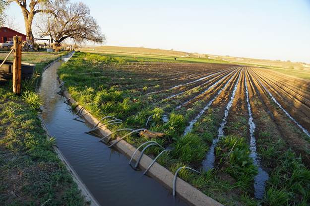
Flood irrigation in the Arkansas Valley via Greg Hobbs
From DWR/CWCB:
In early April, the Division of Water Resources (“DWR”) and the Colorado Water Conservation Board (“CWCB”) will jointly hold four informational meetings and solicit public input related to the implementation of House Bill 16-1228, known as the Agricultural Water Protection Water Right Bill. This legislation, enacted in 2016, allows water users, if they choose, to change an irrigation water right through the water court to an “Agricultural Water Protection Water Right.” The change allows a portion of the water right to be put to a new beneficial use through a substitute water supply plan (“SWSP”) approved by the State Engineer, while a portion of the original water right must continue to be used for agricultural purposes. The legislation directed the CWCB to develop Criteria and Guidelines to address provisions in the bill and directed the State Engineer to promulgate rules that would guide the approval of a SWSP.
The meetings will be held at the following times and locations:
Monday, April 3, 3 – 6 p.m., Island Grove Regional Park, Events Center Conference Room A, 501 N 14th Ave, Greeley, CO 80631
Tuesday, April 4, 3 – 6 p.m., Otero Junior College Student Center Banquet Room, 1802 Colorado Ave, La Junta, CO 81050
Wednesday, April 5, 3 – 6 p.m., Sterling Public Library Community Room, 420 N 5th St, Sterling, CO 80751
Thursday, April 6, 3 – 6 p.m., Upper Arkansas Water Conservancy District Board Room, 339 E Rainbow Blvd # 101, Salida, CO 81201
The agenda for each meeting will be the same: description of House Bill 16-1228; discussion of the draft SWSP Rules; and discussion of the draft Criteria and Guidelines for the Agricultural Water Protection Program. Please visit the DWR website for more information on the legislation, public meetings, and process for providing feedback. The CWCB’s draft Criteria and Guidelines and the State Engineer’s draft Rules related to the implementation of House Bill 16-1228 are also available on the website, and the public is encouraged to review these drafts before the meetings.
Please use this link to RSVP to a particular meeting location by March 30 if you plan to attend.
The Colorado Water Conservation Board and the Colorado Division of Water Resources will hold a series information and input meetings on the new Agricultural Water Protection Water Right law.
There will be a meeting in Sterling April 4 from 3 to 6 p.m. at the Sterling Public Library.
Correction: The meeting is April 5th.
The new law, which was sponsored by both Rep. Jon Becker, R-Fort Morgan, and Sen. Jerry Sonnenberg, R-Sterling, installs safeguards in the event that irrigators want to change part of their water right to a new beneficial use.
Under Colorado water law, an irrigator who wants to lease part of his water to another end-user must go through a state water court process to get what is called a “decree change.” A key to the decree change is making sure the irrigator maintains the return flow that would have resulted from using the water for irrigation. Return flow is water that has been used to irrigate a crop and either runs off or seeps down into the river aquifer to be used by irrigators downstream.
Because water leases tend to be temporary, they are called “alternative transfer methods” because they are an alternative to buying the irrigated land outright and drying up the farmland, a practice called “buy and dry.”
Previously, the irrigator had to have a specified end user for the ATM. If a change in the end user was desired, the irrigator had to go back to water court and repeat the decree change process.
Under the new law, an irrigator will be able to change the end-user by submitting a substitute water supply plan to the state engineer’s office. The SWSP will have to include an explanation of how the irrigator will maintain his return flow obligation. The irrigator will still have to have a conservation program in place through a local agency such as a water conservancy district or irrigation district.
Joe Frank, manager of the Lower South Platte Water Conservancy District, said the new law is an improvement over a similar measure that was introduced a year before.
“Before, there was some fear that (water transfers) could lead to speculation, and that’s just not something we want to see,” Frank said. “(SB 16-1228) allows some flexibility, but reins in on the speculation piece so you can’t change all of your water right.”
He said that while such alternative transfer methods are becoming more common, they aren’t ideal as a solution to the water shortage.
“We don’t want to make this the end-all solution to the gap (in water supply) because it is still drying up some ag, but it isn’t a permanent dry-up,” Frank said. “The good part is you don’t have to keep going back to change your end-user.”
Seven Western Slope Republican lawmakers have sent Gov. John Hickenlooper a message: No more water for the Front Range until it better uses what it already has.
The message, delivered through a Feb. 4 letter obtained by The Colorado Independent, is directed mostly at just one area of the state: Denver and the northern Front Range.
For the past 100 years, as the Front Range population and the state’s Eastern Plains agricultural economy have grown, water from the Western Slope has been diverted to the Front Range through a series of tunnels built through the mountains, known as transmountain diversions. But Western Slope water watchers are getting increasingly nervous about the potential for more of those diversions, pointing to a growing need for water in their area for agriculture and recreation and to fulfill multi-state contracts that require Colorado to send Western Slope water to other states, such as California, Arizona and Nevada.
The Front Range must do a better job of storage and conservation before turning to more diversions, the lawmakers wrote. To that end, they implored the governor to make sure any water projects that receive state funds match criteria outlined in the Colorado water plan. The plan calls for the state to conserve at least 400,000 acre-feet of water and to build storage, without specific projects identified, for another 400,000 acre-feet of water. One acre-foot of water is 326,000 gallons, the amount of water used by two families of four per year.
“We would ask for the consistent – and transparent – use of those criteria” when looking at new water projects that would divert water from the Western Slope to the Eastern Slope, they wrote.
The letter is a follow-up to one sent in November 2015, just before the water plan was finalized. That four-page document said the water plan “cannot place Front Range development interests over the autonomy, heritage and economy of Western Slope communities. Nor can the Plan allow the protection of agriculture in one area of state [sic] to come at the expense of agriculture in other areas of the state.”
The water plan is intended to address a looming water shortage of one million acre-feet of water by 2050, when the state’s population is expected to nearly double from about 5 million to more than 10 million people.* The lawmakers worked with the Northwest Colorado Council of Governments’ water committee on both letters, said Torie Jarvis, the staff person to the committee. She said the letters are primarily directed at the South Platte Basin, which covers most of the northern Front Range, the northern half of the Eastern Plains and the Denver metro area.
Jarvis said the letter is not about current water projects underway in the region that also plan to use water from the Western Slope, most notably two reservoir projects under the control of the Northern Colorado Water Conservancy District.
“We have good agreements in place” on those projects, Jarvis told The Colorado Independent.
The issue also is the water plan itself. “It imagines what a new diversion would look like,” Jarvis said, which means a focus on development and growth rather than on conservation.
The 2015 letter was signed by eight Republican lawmakers, six of whom are on the 2017 version (two of the 2015 signees are no longer in the legislature). The five Democratic lawmakers who also represent the Western Slope were not included. Also not included: Rep. Diane Mitsch-Bush of Steamboat Springs, a member of an interim water resources review committee that led a statewide review of the water plan. Mitsch-Bush said she had not been asked to sign it but would have, based on its description. Jarvis said the Republican lawmakers decided who should sign the letter, adding that she believes all of the Western Slope Democrats would have signed it.
James Eklund, executive director of the Colorado Water Conservation Board, which authored the water plan, said this week that the letter “underscores the importance of Colorado’s Water Plan and demonstrates that implementation will be a collaborative effort.”
He also noted that an annual water projects bill that was introduced in the state House last week would focus on implementing key parts of the state water plan and would address water needs in every part of the state.
*Correction: to note that Colorado’s population in 2050 is expected to be more than 10 million people.
A Pi Day pie from Reilly’s Bakery in Biddeford at Biddeford High School in Biddeford, ME on Friday, March 13, 2015. (Photo by Whitney Hayward/Portland Press Herald via Getty Images)
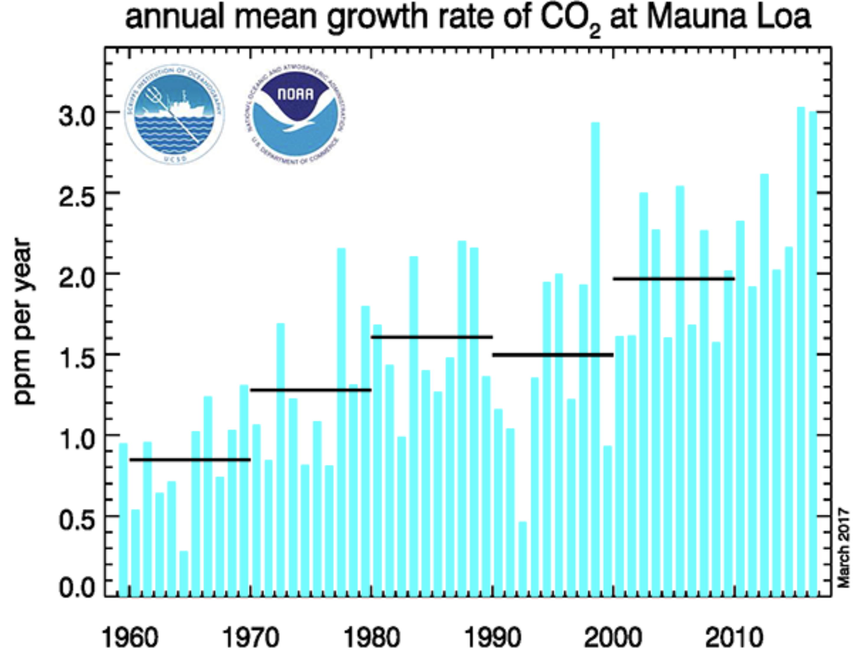
For the second year in a row, atmospheric carbon dioxide concentrations have climbed at a record pace. According to data from the National Oceanic and Atmospheric Administration, carbon dioxide levels jumped by three parts per million in both 2015 and 2016 and now rest at about 405 parts per million.
It’s the biggest jump ever observed at the agency’s Mauna Loa Baseline Atmospheric Observatory in Hawaii, where the measurements were recorded. Similar observations have been recorded at stations all over the world, said Pieter Tans, who leads the Carbon Cycle Greenhouse Gases group at NOAA’s Greenhouse Gas Reference Network.
Throughout the last decade, the average rate of increase has been around 2.3 parts per million per year, Tans added.
This graph shows the annual mean carbon dioxide growth rates observed at NOAA’s Mauna Loa Baseline Atmospheric Observatory. Further information can be found on the ESRL Global Monitoring Division website. (NOAA)
In March 2015, NOAA scientists found that the monthly global average concentration of carbon dioxide exceeded 400 parts per million for the first time. This concentration is a symbolic threshold set by scientists as a kind of milestone to help illustrate the remarkable human-caused growth of greenhouse gases in the atmosphere. For comparison, atmospheric carbon dioxide levels averaged about 280 parts per million up until the industrial revolution.
Since then, all signs have suggested that we’re now living in a permanently post-400 parts per million world. In September 2016, the time of year when atmospheric carbon dioxide levels are usually at their lowest, scientists observed that the monthly average concentration still remained above this threshold. And now, the new NOAA measurements further indicate that carbon dioxide levels are only continuing to grow — and they’re rising at breakneck speed.
It may be a little confusing to consider this news alongside other recent reports, which suggest that global carbon emissions caused by human activity have actually remained fairly flat for the past three years. The fact is, even if emissions have remained pretty stable in recent years, humans are still pouring billions of tons of greenhouse gases into the air each year.
And even if these emission levels really are starting to plateau — and it will be years before we can say whether that’s actually the case, or whether the recent flattening is just a blip on an otherwise upward trend — they’re still evening out at an all-time high, after decades of climbing. Additionally, carbon dioxide remains in the atmosphere for a long time, Tans noted. This means that new carbon dioxide emissions have a cumulative effect, adding to emissions that were already there.
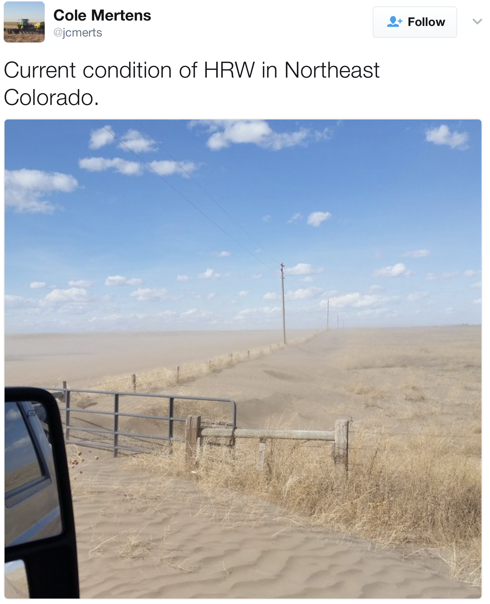
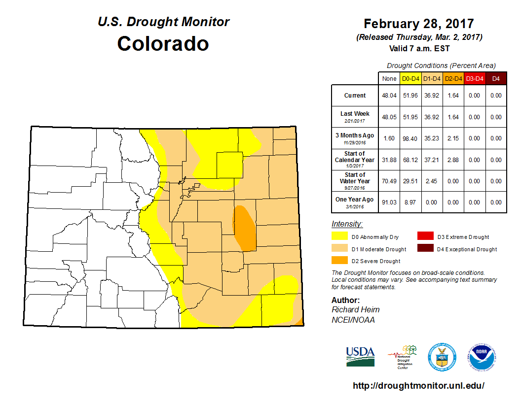
The latest figures from the U.S. Drought Monitor show the entire eastern half of the state is abnormally dry, and that portions of each county east of the Rockies are experiencing moderate drought conditions.
Much of Lincoln County is also experiencing severe drought conditions.
And in Colorado’s southeastern-most county, Baca County, the gamut of drought conditions is present: The western half of the county is abnormally dry, but as one goes into the southeastern portions of the county, conditions go to moderate, severe and extreme drought…
The monitor estimates 3.6 million people in Colorado are under drought conditions.
A year ago, 86 percent of the state was experiencing no drought conditions.
To contrast, the mountain basins are still above 100 percent snowpack for the year after bouts of heavy snow in January.
The dry weather has led to more than a dozen fires across the Front Range in the past two months, and comes ahead of the normal fire and flood season.
But Colorado is prone to fires and flooding year-round, and snow melt runoff and rain storms can create flooding quickly, especially in areas with recent burn scars from wildfires. The National Weather Service says that just a half-inch of run on a burn scar can lead to devastating flooding.
The Federal Emergency Management Agency estimates that 65,000 homes and 15,000 commercial and business buildings sit within Colorado’s floodplains.
George Washington addresses the Continental Congress via Son of the South
FromThe Grand Junction Daily Sentinel (Charles Ashby):
SB36, that cleared the Colorado Senate unanimously, got a bit bogged down in the House Judiciary Committee because of lengthy discussions about what it would do.
Under the bill, introduced by GOP Sens. Ray Scott of Grand Junction and Don Coram of Montrose, appeals of groundwater rights decisions by the Colorado Ground Water Commission shouldn’t include new evidence, just like in any normal court appeal.
Scott, and the House sponsors of his bill, Reps. Jenni Arndt, D-Fort Collins, and Jon Becker, R-Fort Morgan, say the current practice that does allow that isn’t fair.
The lawmakers say most disputes pit farmers and ranchers against water developers who are trying to sell water rights for municipal use, something that can be highly profitable.
Those developers often will drag farmers into court, retrying the case at the appellate level using evidence not considered before the commission the first time, supporters of the bill said.
“It is a matter of being out monied,” said Dan Farmer, a member of the commission and a Colorado Springs rancher. “When we win, we don’t win because we’re short $60,000 (in attorneys’ fees). It’s just not possible to continue to operate a farming operation and try to protect your water rights.”
Opponents of the bill say there is nothing wrong with how cases are tried, saying only a few end up being appealed.
Denver water attorney Sheela Stack, who routinely represents municipalities in water disputes, said it isn’t just the farmers and ranchers who see high litigation costs.
“It goes both ways,” she said. “It’s not just a municipality coming into a groundwater district. We are not trying to bleed the farmers dry. All we are doing, what anybody is trying to do is do the maximum utilization of water.”
The commission is the only state agency that has quasi-judicial powers that current law, established about 40 years ago, allows appeals to include new evidence. Disputes are first reviewed by administrative law judges in the State Engineer’s office, an agency under the Colorado Division of Water Resources, and then decided by the commission.
At the El Pomar Fountain in the shadow of the Union Avenue bridge, Christopher Burke, vice president of Colorado Utility Operations for Black Hills Energy, officially transferred ownership of water rights and water diversion infrastructure to officials representing Pueblo Water, the city of Pueblo and Historic Arkansas Riverwalk of Pueblo.
The water rights, appraised at $280,000, were donated to Pueblo Water. To the city were given water diversion infrastructure — head gates, tunnels, diversion dams, ponds, etc. — and the pipeline that carries water from the Arkansas River to the HARP channel.
Formerly, this system was used to transmit cooling water to the now-decommissioned power plant but now has become an essential part of the operation of HARP’s water course.
While the water infrastructure is nearly a century old and is fully depreciated, the hypothetical cost of replacing these assets critical to properly operate the water flows would be substantial
The Dolores Water Conservancy District board voted unanimously on Thursday to close Totten Lake to all boating to prevent contamination by non-native quagga and zebra mussels…
The Totten closure follows a boating ban on Narraguinnep Reservoir, enacted last week by the privately owned Montezuma Valley Irrigation Co., which also cited the mussel threat.
“To prevent a mussel contamination, and to be consistent with MVIC’s decision, the board voted to prohibit all boating on Totten,” said DWCD general manager Mike Preston.
The boating ban on the two lakes is for all non-motorized and motorized, and includes kayaks, canoes, stand-up boards, windsurfers, oar boats, rafts and jet-skis. Fishing at the popular lake will be allowed from the shore.
“There was a lot of debate on our board about possible exceptions, but the board decided that to be clear, and best protect our irrigators, the ban will be to all boating,” said MVIC manager Brandon Johnson.
A boating closure order for Totten is being drawn up in cooperation with the Colorado Parks and Wildlife, which manages the fishery. A locked gate on the boat ramp will be installed soon. Narraguinnep already has a locked gate installed. Violators at Totten and Narraguinnep will be issued tickets by Parks and Wildlife and the Montezuma County Sheriff’s Office.
Boat inspection stations are effective at preventing a mussel contamination in lakes. But there is no funding for inspection stations at Totten or Narraguinnep, so managers say their only other option is to close them to boating because the contamination risk is too great.
The Dolores Water Conservancy District is also tightening up boating access on McPhee this year to better prevent the mussels from entering the regional irrigation reservoir.
Boating is still allowed at McPhee because there is funding for boat inspections. But access for motorized and trailered watercraft is only allowed during the season through two boat inspection stations at the McPhee and House Creek boat ramps.
When the stations are closed, newly installed locked gates will prevent lake access. In the past, boats could still launch when the inspection stations were closed.
To accommodate boaters who return to the ramps after the boat stations are locked, one-way spike strips will be installed this season to allow boaters to exit the lake after hours.
“We made that concession to prevent boaters from becoming stranded on the lake,” said McPhee engineer Ken Curtis.
McPhee managers adopted the state standard for preventing the mussel that requires trailered and motorized boats to be inspected, but allows non-motorized, hand-launched craft to enter the lake anywhere without inspection.
In general, non-motorized kayaks, canoes, rowboats, stand-up boards, and windsurfers pose less of a risk or contaminating a waterway with mussels.
However, mussels on a boat from an infected lake can be transported to another waterway.
All boats and their motors should be cleaned, drained and dried before entering a waterway and after leaving a waterway.
MVIC also owns Groundhog Reservoir, and is considering closing it to boating. A decision is expected soon.
Here’s a guest column from Don Coram that’s running in The Durango Herald:
In my last column, I mentioned that Senate Bill 36, “Appellate Process Concerning Groundwater Decisions,” had recently passed the Senate 35-0. This exact bill passed the House last year with 60 votes, only to die in the Senate. Powerful men and big money did not offer any opposition in the House last year, but put a full-court press on Senate leadership to kill the bill.
This year is exactly the opposite. Water investors and municipalities have once again rallied their expensive lobby corps to pressure legislators. What amazes me is that people who voted for the bill last year, at least twice and some cases three times, are now suddenly opposed. Unconfirmed reports have told me that Northern Water in Weld County is the driving force behind the opposition.
As someone from rural Colorado, who understands the issues of rural Colorado, I am amazed that legislators who portrays themselves to be pro agriculture — as men standing up for the little guy, the second or third generation farmer or rancher who is just trying to survive and hopes that the next generation can pay off the mortgage — can be in opposition to this bill.
What has happened is investors buy ground water and then go to the Ground Water Commission and file for a change of use in hopes of exporting the water from the ground water basin and sell it to the municipalities. If the investors lose in the appeal process they claim new evidence. The farmer must hire a lawyer and water engineer to defend his water once again at thousands of dollars. One family has spent around $900,000 on attorneys fees. The fastest way to break a farmer is through litigation.
It is disappointing to me that a legislator can turn 180 degrees from one year to the next. The exact same bill should be treated the same. If you liked the bill last year, you should like it this year. Likewise, if you opposed it last year, I would expect the same this year.
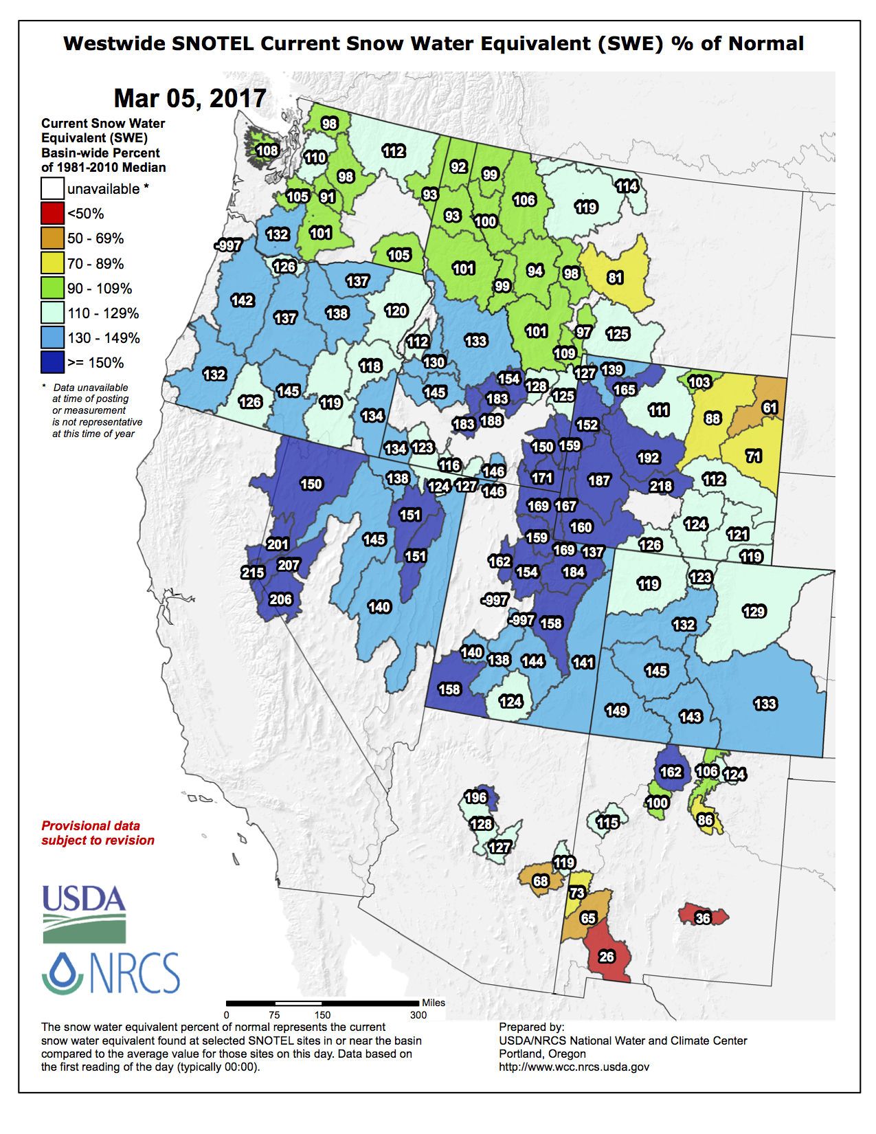
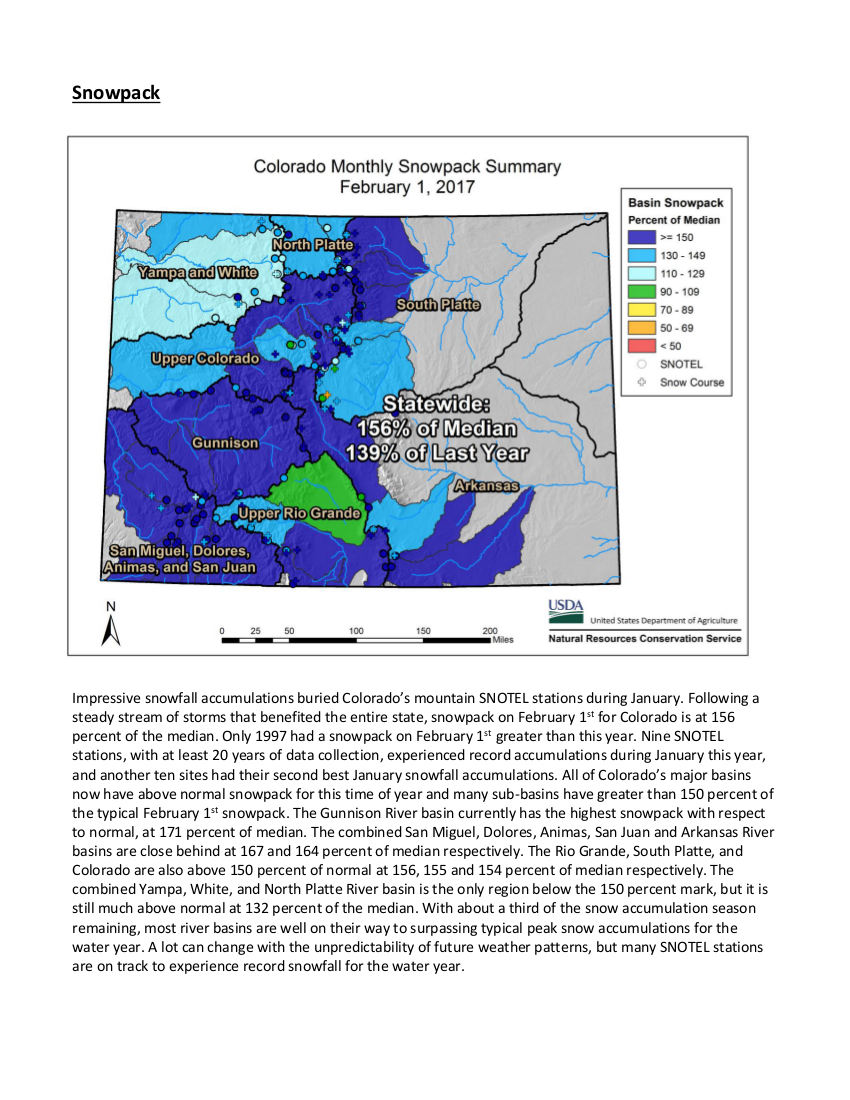
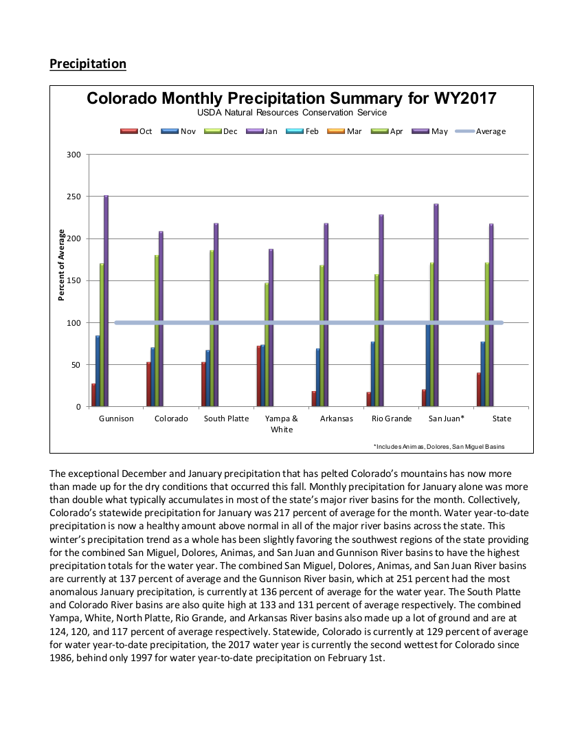
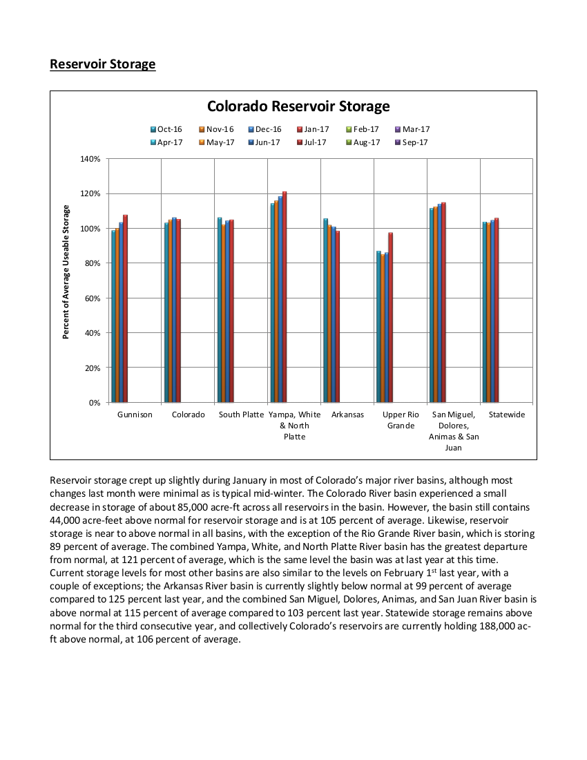
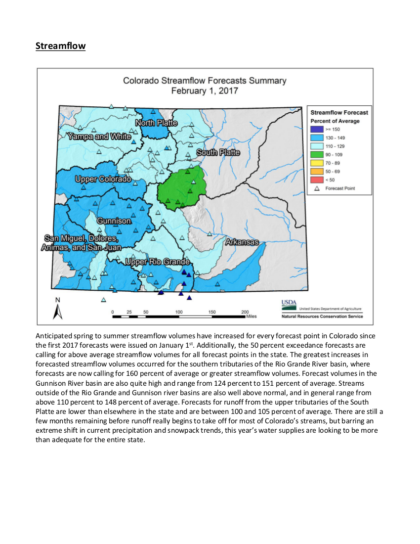
Colorado received well above normal mountain precipitation and snowpack accumulation throughout the month of January, with all but one major basin receiving more than twice the normal amount of monthly precipitation. The combined Yampa, White, and North Platte basins experienced the lowest January precipitation at 187 percent of average and the Gunnison had the highest at 251 percent. Statewide January precipitation was 217 percent of average. This substantial accumulation of precipitation left the statewide snowpack at 156 percent of normal as of February 1st, a notable increase from the 114 percent that was recorded as of January 1st. Streamflow forecasts across the state range from near to well above normal seasonal volumes. On the low end there are several forecast points in the South Platte basin that are currently forecast to have between 101-110 percent of their average April-July streamflow volumes. While most streamflow forecasts in the state range between 110-150 percent of normal, there are several streams in the Upper Rio Grande basin that are forecast to have between 175-185 percent of average streamflow this season. Reservoir storage has remained relatively constant, relative to normal, throughout this water year and is currently 106 percent of average statewide.
Statewide Time Series snowpack summary March 6, 2017 via the NRCS.
The permanent boating ban went into effect Tuesday, said Brandon Johnson, general manager of the Montezuma Valley Irrigation Co., which owns the reservoir.
“We can’t afford to get the mussel in there because of the damage they cause to our infrastructure,” he said. “We had to take drastic action against this threat because we’re in the irrigation business, not the recreation business.”
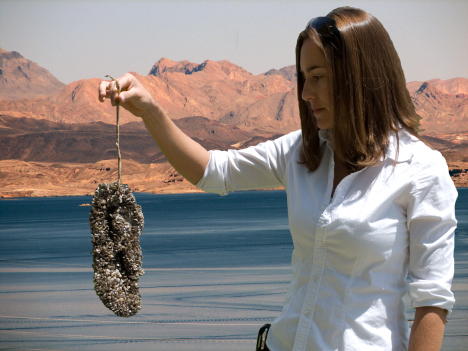
Mussels from infected lakes, including Lake Powell, can travel in standing water of boats and contaminate other lakes, clogging pipes, valves and canals.
“If they get in there, we can’t deliver water to our stockholders, costs will increase to mitigate them, and they will get into side rolls and pipes,” Johnson said.
The Narraguinnep ban is for all boats, motorized and non-motorized, and includes jet skis, fishing boats, row boats, kayaks and canoes. Colorado Parks and Wildlife would enforce the ban and issue tickets.
Whether paddle boards and windsurfing would be allowed is not clear. “The board decided on a boating ban,” Johnson said. “Whether those two are boats is up to the enforcement agencies.”
MVIC also owns Groundhog Reservoir and is evaluating whether it will close that lake to boating, Johnson said.
Boating could possibly continue at Narraguinnep if there were a boat inspection program, he said, but the irrigation company cannot afford it.
“Recreation is the responsibility of Colorado Parks and Wildlife,” Johnson said.
Parks and Wildlife operates local boat inspection programs, including for McPhee Reservoir, to check for the mussel and decontaminate boats.
But CPW spokesman Joe Lewandowski said the agency does not have the funding to add more boat inspection programs.
“We’re scrambling for funding for the lakes where we do have inspection stations. They are costly to operate,” he said…
McPhee Reservoir is also restricting access to the lake beginning this year to prevent a mussel contamination. Boat ramps at McPhee and House Creek will be gated, and trailered boats can launch only when boat inspection stations are open.
The McPhee boating restriction does not include hand-launched, non-motorized boats such as canoes, kayaks, rafts, windsurfers and paddle boards. Non-motorized, hand-launched boats are free to launch anytime from anywhere on McPhee. However, all boat owners should make sure to clean, drain and dry all boats before and after entering any waterway to avoid invasive species contamination.
“The big snow events in the metro area honestly do not help us,” said Emily Hunt, Thornton’s water resources manager. “We’d really much rather see the snow up in the mountains. But if we can keep cold weather down here through March, with the trees barely starting to come out in April and people not turning on their irrigation systems until May, that’s ideal for us. Ideally, we don’t want people to have to water their lawns and trees until after Mother’s Day.”
The latest reports for Colorado’s Front Range put snowpack depth at between 120 and 160 percent of annual averages, according to the National Resources Conservation Service.
It’s one of the several measurements local water officials monitor all year long as they prepare for the summer.
“It’s great when the snowpack tracks its normal route, or it’s above-normal route like this year,” Hunt said. “But the other measure is the snow water equivalent, and that really tells us how much water is actually in the snowpack. For us, that usually maxes out about 15 inches.”
NRCS measures show the Snow Water Equivalent along the Front Range at between 13 and 17 inches.
“If we get to 15 inches or higher, then we feel like we are having a normal year,” Hunt said.
Those show that the Denver metro area should avoid drought conditions and water restrictions for another summer…
Hunt said the weather down here can have just as much impact. People use more water when it gets warm. She’d prefer that waits until the local reservoirs have started filling up.
Westminster, Thornton, Northglenn and the Farmer’s Reservoir and Irrigation Company all rely on Standley Lake as one of their main water supplies, but each city has a number of other reservoirs and canals that feed municipal water treatment plants.
Click here to read the news release from the Natural Resources Conservation Service (Brian Domokos):
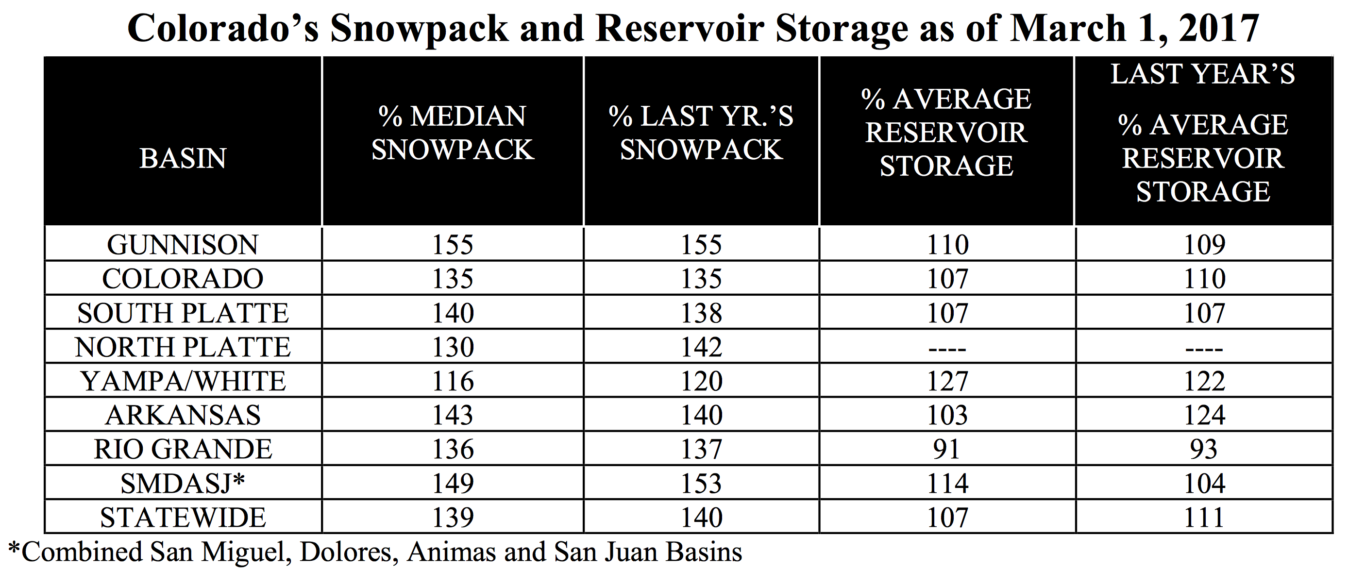
Near normal February precipitation graced Colorado after significant accumulations during December and January. February totals were as low as 88% of normal in mountains of the Arkansas River basin and as high as 119% the South Platte River basin, with the average across the state on par with normal at 100%. “Statewide year to date precipitation now stands at 123% of normal on March 1 while snowpack is a robust 139% of normal” said Brian Domonkos, Colorado Snow Survey Supervisor. He continued, “All but two of the major basins in Colorado have already surpassed average annual peak snowpack.” Those two basins are the South Platte and combined Yampa & White basins. Snow accumulations typically continue through early to late April.
Statewide Time Series snowpack summary March 6, 2017 via the NRCS.
The plentiful snowpack in the San Juan and Sangre de Cristo Mountains is excellent news for water users in the Rio Grande where snowpack conditions in the previous six years failed to reach normal peak snowpack. Snowpack this year in the Rio Grande surpassed the average annual peak snowpack in mid- February and soared higher with late February storms. While predicted runoff is not as favorable as the present snowpack situation, forecasts point to near to above normal runoff. Reservoirs in the Rio Grande basin, currently at 91% of normal storage, have not breached the normal mark in over seven years, hope to see a boost from the plentiful snowpack.
Statewide reservoir storage is slightly above normal at 107% heading into what streamflow forecasts are indicating will be an above normal runoff year in most watersheds. With nearly all runoff projections pointing toward at or above normal streamflows, many locations will likely see adequate water supplies. Further to the southwest conditions warrant a more watchful eye where runoff projections are currently well above normal in the Gunnison River and Western San Juan mountain watersheds. Despite favorable outlooks sufficient time remains to significantly change predictions from dry, warm and windy weather to cool and rainy or snowy, future weather can still impact runoff even in years of surplus snowpack. Continued monitoring and forecasts are needed to prepare for suitable water management.
Snowpack and reservoir storage March 1, 2017 via the NRCS.
The Snow Survey is a division of the U.S. Department of Agriculture’s Natural Resources Conservation Service in Colorado. A skier and a whitewater rafting enthusiast, Wetlaufer follows the snow-water equivalent — the amount of water in fallen snow — closely throughout the season. He echoed a statement powder hounds have been saying since January — in the Eagle River Basin, this has been a good season for snow.
“Many sites in the Eagle River Basin have already reached their normal peak (snow-water equivalent) or snowpack values, or if they are not, they are very close to it,” Wetlaufer said Thursday. “At many of those sites those don’t usually occur for at least another month or so.”
“Currently, the Eagle River at Gypsum is forecasted to have 115 percent of its normal volumetric summer stream flows,” Wetlaufer said. “A lot of it depends on the timing at which the snow melts and translates to stream flow, but it looks like pretty good flows in the rivers for the whitewater enthusiasts.”
Westwide SNOTEL basin-filled map March 10, 2017 via the NRCS.
Yampa/White/Green/North Platte river basins via the Colorado Geological Survey
From the Colorado Ag Water Alliance (Marsha Daughenbaugh) via Steamboat Today:
If you have an agriculture water right, then the Colorado Ag Water Alliance workshop is for you. If you are concerned about the future of Colorado’s water, then the CAWA workshop will be of interest to you. If you want to learn more about water, you might attend the CAWA workshop.
The Colorado Ag Water Alliance is composed of representatives from all the major ranching and farming organizations in the state. The organization’s goal is to preserve Colorado’s irrigated agriculture through education and constructive dialogue. Its role is to provide the best information to Colorado’s agricultural water users and increase the understanding of water rights to help balance the gap between limited water supplies, population growth and the deficit in the Colorado River Basin.
CAWA engages with a variety of entities to address environmental and economic concerns. Currently, CAWA is hosting a series of meetings throughout Colorado to allow and encourage agricultural producers to take an active role in the implementation of the Colorado Water Plan.
A workshop for the Yampa-White-Green River Basins will be held from noon to 4 p.m. March 22 at the Steamboat Springs Community Center, 1605 Lincoln Ave. The workshop is free, and lunch, featuring locally produced food, will be served.
Discussion topics will include the Colorado Water Plan, status of the Colorado River Basin, alternative transfer methods, water leasing, water banking, “use it or lose it” policies, water efficiency and waste, challenges of ditch renovations, collaboration opportunities and research results.
Speakers from CAWA, Colorado Water Institute, Colorado Cattlemen’s Association, Colorado River Water Conservation District, Colorado Division of Water Resources, Colorado Water Trust, Trout Unlimited, The Nature Conservancy and the Maybell Ditch Company will give spirited, quick presentations explaining different parts of Colorado’s complex water issues. Attendees will be encouraged to ask questions and provide feedback throughout the afternoon.
Colorado’s population is predicted to double to 10 million people by 2050, bringing with it a water shortage of more than 500,000 acre-feet per year. Agricultural water rights are being scrutinized as a potential solution to the deficit.
Ideas take time and multiple discussions before anything becomes reality. This workshop is part of a much larger conversation, and it is critical that agricultural producers provide their invaluable knowledge and voices to the deliberations. If not you, then who will speak up? This is a close-to-home opportunity for Northwest Colorado agriculture to participate.
Those planning to attend are encouraged to RSVP to yampaag.eventbrite.com for a lunch count.
This workshop hosted by CAWA, Community Agriculture Alliance and the Yampa-White-Green Basins Roundtable. Other sponsors include CSU Routt County Extension, Colorado Cattlemen’s Association, CSU’s Colorado Water Institute, Colorado Water Conservation Board, Colorado Corn and Rocky Mountain Farmer’s Union.
Marsha Daughenbaugh is the executive director of the Community Agriculture Alliance and a member of the Routt County CattleWomen.
Click here to go to the American Society of Civil Engineers website to read the report. From the website:
Every four years, the American Society of Civil Engineers’ Report Card for America’s Infrastructure depicts the condition and performance of American infrastructure in the familiar form of a school report card—assigning letter grades based on the physical condition and needed investments for improvement.
Active weather across the Midwest during the beginning and end of the current period brought rain and severe storms over the region. Warm and windy conditions dominated conditions on the Plains; wildfires were a great concern throughout Oklahoma and Kansas, with multiple fatalities associated with the fires. Temperatures from South Dakota into Texas were 6-9 degrees above normal, with portions of eastern Nebraska and eastern Kansas 9-12 degrees above normal. Much of the West was cooler than normal with departures of 3-6 degrees below normal. Rain and snow over parts of northern California and into the coastal regions of Oregon and Washington continued the active pattern that has been consistent over the West Coast. The driest areas of the Southeast did pick up some precipitation, but most areas were normal to slightly below normal for the week…
High Plains
A warm, windy, and dry week dominated the High Plains, with only scattered rain over the region. Conditions are drying out with the windy and warm weather and any moisture recently received has been evaporated quite rapidly. Abnormally dry conditions were expanded over southeast Nebraska and into eastern Kansas while moderate drought was expanded over eastern Kansas as well. In southwest and south-central Kansas, moderate and severe drought were expanded slightly this week too. This area will need to be monitored closely for further degradation if precipitation does not materialize…
West
Cooler than normal conditions dominated the West, with precipitation over the coastal regions and into the Southwest. Several improvements were made this week in response to not only recent precipitation but also precipitation over the last several months. In Montana, good snow totals allowed for some improvement to the abnormally dry conditions. Abnormally dry conditions were removed from eastern Oregon due to the short-term indicators improving the overall conditions and superseding the long-term indicators. In southern California, severe drought was eliminated in the Santa Barbara, Ventura, and Los Angeles county region as the response from recent rains has improved long-term impacts to groundwater. Improvements were also made in the Imperial Valley in response to recent rains where abnormally dry, moderate drought and severe drought were all improved. In Arizona, abnormally dry conditions were improved over the eastern portion of the state as well as the central portion of the state. Some abnormally dry conditions were left in place because of the low snow totals from this current water year…
Looking Ahead
Over the next 5-7 days an active pattern will develop over the South and into portions of the Southeast. Up to 2 inches of rain is projected from south Texas into portions of Louisiana and Mississippi. Another storm system will impact the Pacific Northwest with both coastal and inland regions anticipating over 4 inches of rain and snow accumulating in the upper elevations. Cooler air will move south out of Canada, bringing with it colder than normal temperatures over the eastern half of the United States. Warmer than normal temperatures are expected over much of the West and Southwest, with departures of up to 12 degrees above normal.
The 6-10 day outlooks show a high probability of above-normal temperatures centered over the Southwest and impacting most areas from the West, Plains, and Southeast. A higher probability of cooler than normal temperatures is anticipated over Alaska, New England and the Pacific Northwest. The highest probabilities of above-normal precipitation are projected to be over the Pacific Northwest and New England while both the Plains and Alaska are showing the highest chances of below-normal precipitation.
The report classifies about 52 percent of the state as abnormally dry with another 37 percent of Colorado under moderate drought. That includes the entire Front Range from New Mexico to Wyoming, including Pueblo, Colorado Springs, Denver, Greeley and Fort Collins.
Nearly all of Lincoln County is listed as being in severe drought, with a tiny sliver of Colorado’s southeast corner — representing just 0.2 percent of the state — in extreme drought.
The drought levels are slightly above where they were measured last week but far higher than a year ago when roughly 14 percent of the state was classified as abnormally dry.
None of the Western Slope is under drought conditions.
The dry weather has been blamed for contributing to wildfires across the eastern half of Colorado, including a 32,000-acre blaze in Logan and Phillips counties that burned several homes and killed about 200 cattle.
Passages are narrowing as the snow piles up in Crested Butte. Photo/Town of Crested Butte Facebook page
Click here to read the newsletter. Here’s an excerpt:
River-Friendly Snow and Ice Removal
Are you a pusher or a scooper? Of snow, that is.
With all of the snow earlier this winter you likely have a distinct preference for one or the other. I’ll leave it to the medical professionals to advise on proper shoveling techniques. What I’d like to focus on is how to remove snow and ice without negatively impacting our streams. Looking out the window as I write this, it feels a bit out of touch to be writing about snow and ice, but looking at the calendar, I am hoping this information will be put to good use very soon!
Where you put your snow and how you get rid of ice can affect our streams in several ways. Here are some tricks:
First, remove the snow as it falls, before it gets tracked down. This is your first and best defense in preventing ice from forming.
Next, you want to take an extra second to think about where to pile the snow—this will help you down the road. Those that live along a stream may be tempted to push snow into it. After all, “snow is just water.” This is not a good practice, however!
Here is why: Snow from your driveway and sidewalks absorbs oil, antifreeze, overcast fertilizers (particularly with the first snowfall of the year), sand, road salts, or any chemicals that drip off of vehicles. Dumping snow straight into the river introduces all of these to the stream in high concentrations. This reduces water quality, impacting habitat.
Sure, as it melts this is mobilized and makes its way to the stream anyway. However, a large portion of it soaks through the soil first. The ground and our native riparian plants are nature’s water filter, separating the contaminants from the water before it eventually makes its way back to the river.
Therefore, piling the snow in your yard is your greatest option. Pile it in a place where when it melts it doesn’t run across a sidewalk, road or driveway. As we all know, what melts in the day refreezes at night and you could wake up to an ice rink the next morning. A blanket of snow can actually be beneficial to your lawn, as it provides an insulating layer that protects against extreme temperature fluctuations and harsh winds. Additionally, once water reaches an impervious surface (concrete, asphalt, etc.), it’s headed for the gutter and from there the storm sewer—which sees little to no treatment before running straight into a stream near you.
If you follow these tips and still end up with ice, you have a few options. Chipping away by hand provides a great arm and cardio workout right in the driveway. If you are rolling your eyes, you likely are thinking about deicers instead. Deicers, when used properly, are a great tool. When used improperly they can ruin your concrete, impact our streams, hurt your pet’s feet and even ruin your floors if you track them in on your shoes.
Available options range from rock salt (sodium chloride), calcium chloride, calcium magnesium acetate and even urea (fertilizer) or sand. Each has varying costs, benefits and problems—diving into these would take an entire article to cover. That said, sand doesn’t melt ice—it just provides traction. Urea is only effective in high quantities and will runoff into the streams adding excessive levels of nitrogen, which grows algae and causes many imbalances in the stream. It should be avoided out of respect for our rivers and in-lieu of truly better options.
Whatever you use, it’s important to read the label carefully and apply only the amount necessary. If after the ice is melted some of the product remains, you’ve applied too much and can use less in the future. Remember to sweep up the excess before it makes way for the gutter.
Keep in mind that if a product has the potential to damage your landscaping, shoes, concrete or pet’s feet, it will wreak havoc on the nearest stream, too.
Follow these tips and you can rest easy knowing that your snow removal is effective and isn’t impacting our high-quality fishing, rafting and drinking water.
Holly Loff is the Executive Director for the Eagle River Watershed Council. The Watershed Council advocates for the health and conservation of the Upper Colorado and Eagle River basins through research, education, and projects. Contact the Watershed Council at (970) 827-5406 or visithttp://www.erwc.org.
Westwide SNOTEL basin-filled map March 8, 2017 via the NRCS.
FromThe Grand Junction Daily Sentinel (Dennis Webb):
Colorado’s snowpack was at 136 percent of normal Monday, as the state moves into March with most river basins already having surpassed average annual peak snowpack levels typically reached in April.
The Natural Resource Conservation Service’s state office in Colorado said in a news release that statewide reservoir storage was at 107 percent of average as of the start of the month, and streamflow forecasts indicate an above-normal runoff year is coming in most watersheds…
The Gunnison River Basin snowpack stood at 147 percent of median Tuesday, and the Upper Colorado River Basin was at 135 percent.
The Yampa/White river basins have the lowest snowpack level in the state, but still are at 119 percent of median. The San Miguel, Dolores, Animas and San Juan river basins lead the state, at 149 percent, and the Upper Rio Grande is at 143 percent.
Brian Domonkos, snow survey supervisor for the NRCS in Colorado, said in the release that snowpack has exceeded the peak annual average in all parts of the state but the South Platte and Yampa/White River basins.
Reservoir storage levels were at 107 percent of average in the Upper Colorado River Basin as of the start of the month, and 110 percent of average for the Gunnison River Basin.
While storage is at 91 percent of average for the Rio Grande Basin, the NRCS says that plentiful snow in the San Juan and Sangre de Cristo mountains is excellent news for water users there, after six years of snowpack failing to reach the normal peak in the basin. Forecasts for the Rio Grande Basin call for normal to above-normal runoff.
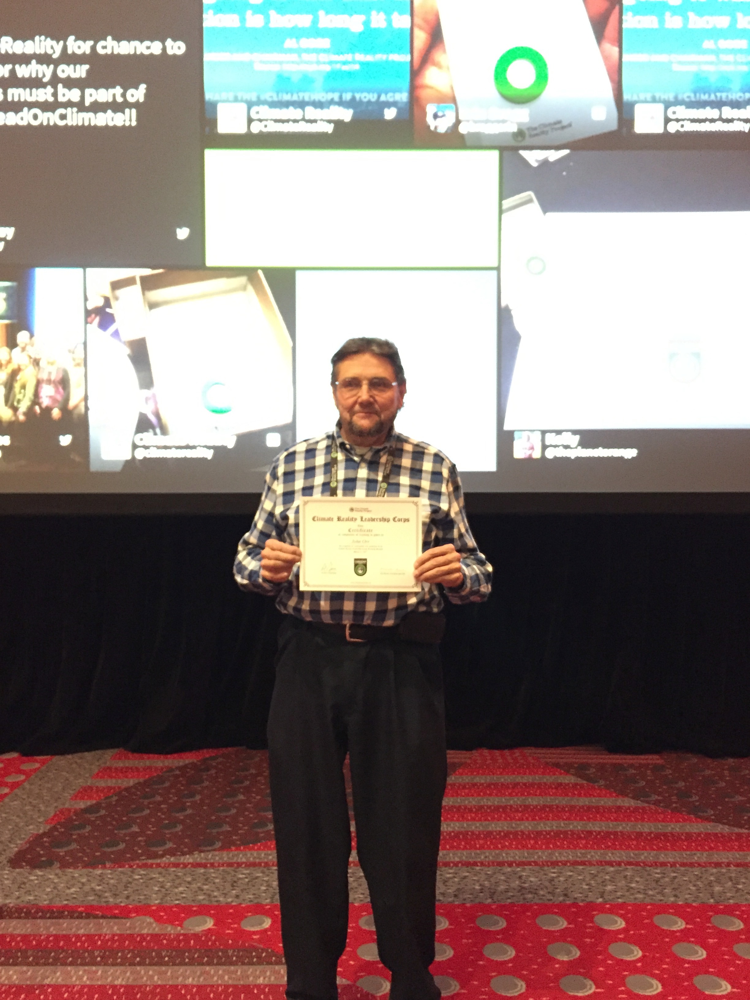
Gore, Climate Reality Leadership Corps’ founder and chairman, devotes around eight hours of his star power at each free, three-day workshop, says President and CEO Ken Berlin, summing up Climate Reality Leadership Corps’ mission as working internationally “to build public support for addressing climate change.” How that’s done here, he says, is by teaching policy to people who commit to “10 acts of leadership” around “positive climate change action” and instructing them on “how to be organizers, how to go back to their communities and be leaders on this issue.”
The nonprofit runs offices in Washington, D.C., and Boulder, and in 10 countries outside the U.S. In response to the election, Berlin says Climate Reality Leadership Corps is transitioning from concentration on federal matters: “The greater chance of progress is going to be on a state level.”
Still, during a two-hour slide show March 2, Gore plugged an April 29 climate march in D.C., saying, “We all need to go to it. I will be there, we need to demonstrate people power, and we need to get active.”
Watching him speak felt just like watching 2006’s Oscar-winning An Inconvenient Truth, which in late July of this year will be succeeded by An Inconvenient Sequel: Truth to Power. However, Gore did tailor many slides particularly for a Colorado audience. He made note of both the Black Forest and Waldo Canyon fires (noting longer and more intense fire seasons) and Manitou Springs flooding, as well as Lamar’s wild 2013 haboob, Fountain’s 2014 tumbleweed invasion and the sad status of the Colorado River and pine and bark beetle infestations in our forests.
From there, he went national and global with a list of 1-in-1,000-year weather events, detailing everything from “rain bombs” that dump tremendous water volumes rapidly to lethal heat waves that have literally melted streets in India. Then there’s the stat about the rate of global warming being equivalent to 400,000 Hiroshima atomic bombs dropped daily. Oh, and climate-driven political destabilization such as Syria’s drought, plus food shortages that kicked off The Arab Spring.
But before attendees could tire of melting glacier and iceberg images or the phrase “point of no return,” Gore took a turn for the positive, championing many worldwide successes. One particularly hopeful slide read: “We expect innovation and global markets, rather than politics, to continue to be the primary driver for growth in low-carbon technologies. In our view, prices for batteries and solar panels will continue to drop, and global market-share gains will continue for wind, solar, EVs and LEDs, regardless of who occupies the White House.”
Over the weekend, Gore announced that Colorado State University has taken Climate Reality Leadership Corps’ 100% Committed pledge to move fully to renewable electricity in the coming years, making it the largest university to do so, to date.
He concluded his talk on both a somber and upbeat note, saying, “This climate movement is right in the tradition of the great moral causes that have led to a better world for all of us. … Every single one of those movements was met with no after no after no, until finally, when all the underbrush was cleared away, and it was resolved into a simple choice between what’s right and what’s wrong, then the outcome became foreordained. … just remember the will to change is itself a renewable resource.”
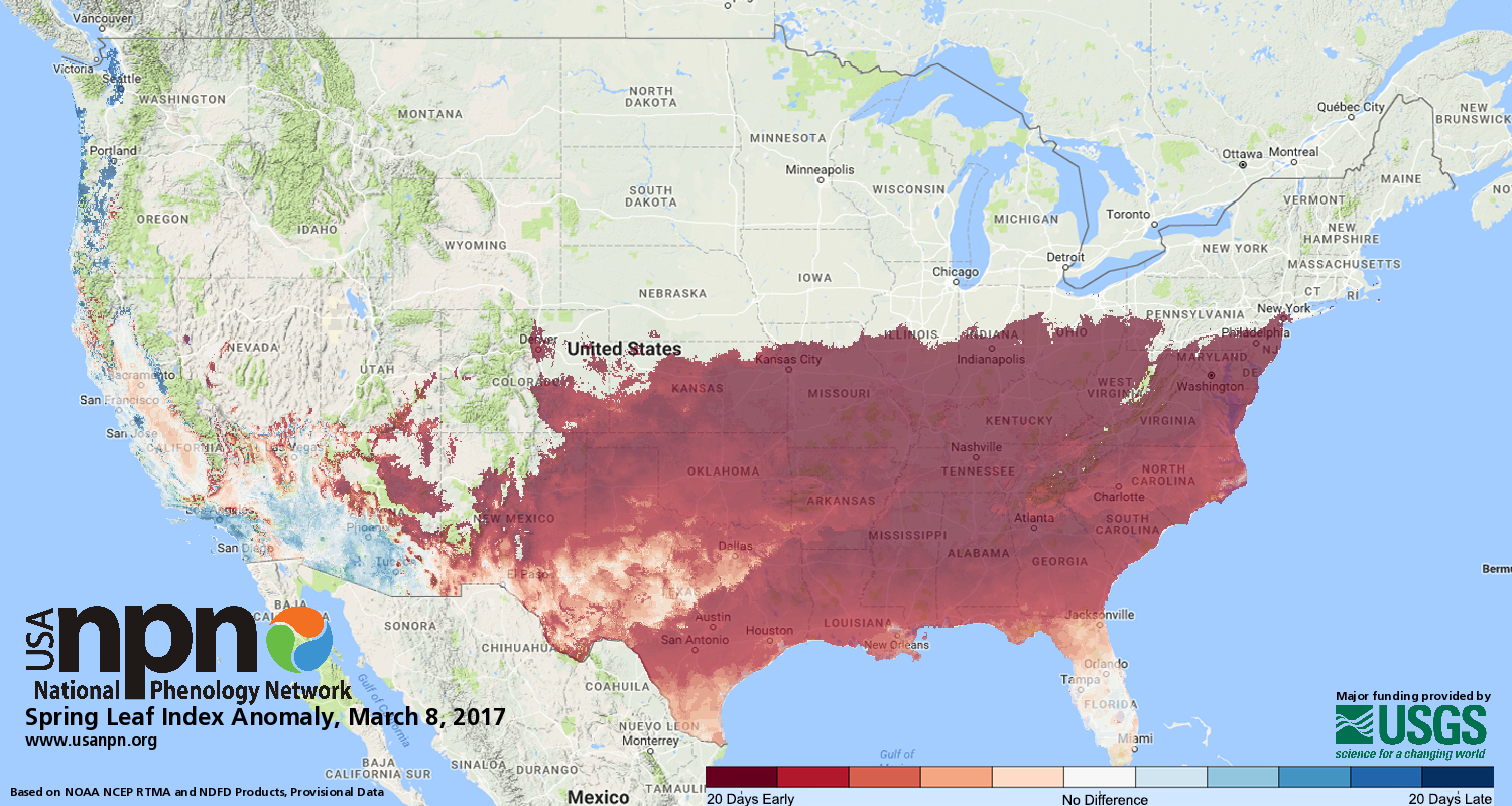
In 2017, we see very large anomalies in the southeastern United States on the Spring Leaf Index map, where the Index was met up to three weeks earlier than what is typical for these locations. The timing of leaf-out, migration, flowering and other seasonal phenomena in many species is closely tied to local weather conditions and broad climatic patterns. The Spring Index maps offered by USA-NPN shed light on plant and animal phenology, based on local weather and climate conditions.
FromThe New York Times (Jeremy White and Henry Fountain):
After a mild winter across much of the United States, February brought abnormally high temperatures, especially east of the Rockies. Spring weather arrived more than three weeks earlier than usual in some places, and new research released Wednesday shows a strong link to climate change.
By the 2017 calendar, the first day of spring is March 20. But spring leaves arrived in mid-January in some parts of the South, and spread northward like a wave. The map above plots the date of “first leaf,” a temperature-based calculation of when vegetation that has been dormant starts to show signs of life. This year, with the exception of a few small areas, the wave has arrived much earlier than the 30-year average.
An early spring means more than just earlier blooms of fruit trees and decorative shrubs like azaleas. It can wreak havoc on schedules that farmers follow for planting and that tourism officials follow for events that are tied to a natural activity like trees blooming. Some plant species that bud early may be susceptible to a snap frost later, and early growth of grasses and other vegetation can disrupt some animals’ usual cycles of spring feeding and growth.
The rise in planetary heat made the freakishly warm February up to 13 times more likely than it was around 120 years ago, according to the analysis by scientists working on the World Weather Attribution team. While it was a month to remember, by mid-century that type of heat could occur every three years unless carbon pollution is curtailed.
The warm spell is just the latest piece in a growing body of evidence that climate change is playing a role in almost all extreme heat events. Winter is the fastest warming season in the U.S. and February is no exception. February temperatures in particular have risen by 3°F since 1895, which is roughly twice as fast as the global average.
This February fits right in line with that trend. It was the second warmest on record for the U.S., trailing only 1954 [during the 3-year drought in Eastern Colorado], according to the National Centers for Environmental Information. The U.S. average for February was 7.3°F above normal, the fifth-most anomalously warm month ever recorded. In all, 16 states had their warmest February on record from Texas to New York…
Scientists used historical data and climate models to understand what was driving the heat. Historical observations show that around 1900, this type of persistent heat was a 1-in-160 year event, but in our current climate it’s now a 1-in-12 year event. Using models to tease out the specific role climate change played, they found that it made the Ferbuary heat at least three times more likely.
If the world continues on its current pace of greenhouse gas emissions, this type of February could become the norm by 2050.
The most probable runoff forecast shows inflow of 440,000 acre-feet for April through July, enough to fill McPhee Reservoir and provide more than a three-month rafting release below the dam.
“Operations this spring are lining up to be exciting,” said Ken Curtis, an engineer with the Dolores Water Conservancy District. “The March forecast is typically not as accurate as the forecast that will come later, but it is good as a planning tool.”
The predicted runoff will fill the reservoir for farmers, with 270,000 acre feet potentially available for whitewater release below the dam. That is enough for an estimated 116-day boating season for approximately 100 miles between the Bradfield Bridge and Bedrock.
By comparison, in 2016, only about 30,000 acre-feet was available for a whitewater release below McPhee Dam, which generated about 10 days of boating flows.
Should the current forecast hold, operators will be able to provide releases of 800 cubic feet per second (cfs) and greater for about 67 days, with flows greater than 2,000 cfs for 45 days, and peak flows of 4,000 cfs for four days. Several ecological benefits also will be realized from a release of that magnitude.
The data in the March 1 operating plan is provisional and subject to change because of Dolores River inflow, future precipitation, weather patterns, managed release criteria and use.
The Dolores Water Conservancy District will be the primary source of information pertaining to release schedules and updates this spring. It will have a newly remodeled website at doloreswater.com.
Last year, the whitewater release lasted about 10 days and only peaked at 1,000 cfs. Before that, there had not been a release since 2011 because of drought conditions and low snowpack.
The main Lower Dolores River boating run stretches for 100 miles through winding, red-rock canyons interspersed with rapids ranging from Class I to Class IV. It is considered one of the premiere multiday boat trips in the nation when it has enough water to run. No permit is required.
The last piece of the renewable energy puzzle is falling into place. The intermittency of solar and wind is being moderated with lithium-ion batteries. Check out the drop in cost below. All of the components of the batteries are recyclable.
Graph showing the decline in costs for large lithium ion batteries in US dollars per kilowatt-hour (kWh), 2006-2016. In a February 2016 report, the research and brokerage firm, Sanford C. Bernstein & Co., asserted that “LiB (lithium ion battery) costs have fallen by a staggering 94% since 1991…this has coincided with the dramatic improvement in battery capability, which is a big part of the cost reduction and further helps the case for LiB adoption across both electric vehicles and energy storage systems.”* Reference: * Sanford C. Bernstein & Co., The Battery Bible: Powering the Future (February 2016).
The amount of solar power added worldwide soared by some 50% last year because of a sun rush in the US and China, new figures show.
New solar photovoltaic capacity installed in 2016 reached more than 76 gigawatts, a dramatic increase on the 50GW installed the year before. China and the US led the surge, with both countries almost doubling the amount of solar they added in 2015, according to data compiled by Europe’s solar power trade body.
Globally there is now 305GW of solar power capacity, up from around 50GW in 2010 and virtually nothing at the turn of the millennium.
The industry called the growth “very significant” and said the technology was a crucial way for the world to meet its climate change commitments.
James Watson, the chief executive of SolarPower Europe, said: “In order to meet the Paris [climate agreement] targets, it would be important if solar could continue its rapid growth. The global solar industry is ready to do that, and can even speed up.”
In the UK the amount of solar power installed in 2016 fell by about half on the record level added the year before. The drop came after the government drastically cut incentives for householders to fit solar panels and ended subsidies for large-scale “solar farms”.
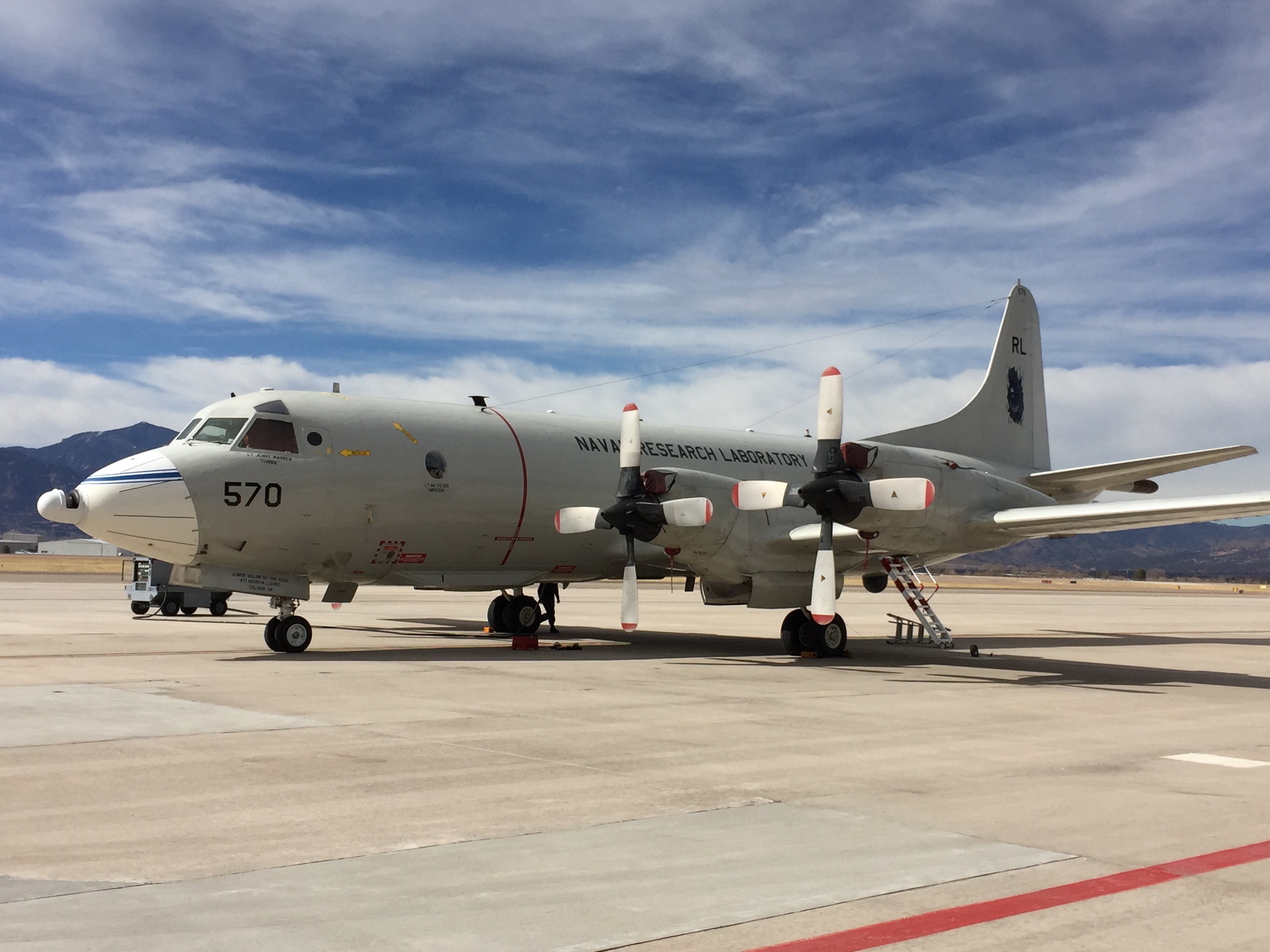
A handful of other scientists, from agencies and universities across the globe, swirled around the clearing and among nearby spruce trees. The researchers measured the snow with poles and rulers, radar and microwave sensors, and even packed a cooler with snow samples destined for micro-CT scanning at a lab in New Hampshire. Overhead, sensors affixed to airplanes made similar measurements throughout the day.
Snow delivers about 60 to 70 percent of the West’s water supply. The snowpack is an icy natural reservoir that swells throughout the winter, then melts during the summer, providing rivers, agricultural fields, and communities with water. But the amount of moisture in snow varies, and keeping track of how wet snow is across an entire landscape — information essential to the resource managers, farmers and scientists who forecast water supplies and flood potential — has proven difficult. To figure out the best way to do it, Hedrick and about a hundred other researchers converged on snowy, flat-topped Grand Mesa, in western Colorado, for an ambitious scientific treasure hunt in February. For three weeks, they took measurements and tested dozens of instruments and methods, looking for the optimum suite of sensors to survey what one scientist calls “the holy grail” of snow-sensing research: the amount of water held within the snow.
Government agencies monitor the Western snowpack at hundreds of locations across the region. But, useful as those point-measurements are, they don’t tell the whole story, says Kelly Elder, a research hydrologist with the U.S. Forest Service in Fort Collins, Colorado, and the leader of the team that managed the ground campaign at Grand Mesa. Aerial measurements from a satellite or a plane that cover the entire landscape — not just a series of individual sites — are also necessary. “If we can measure from space, or from the air, then there’s hope,” Elder says.
Satellites are already doing some of that work: For decades, they have provided information about how much of the globe is covered by wintertime snow. But that’s not enough, says hydrologist Jessica Lundquist at the University of Washington in Seattle. “What that doesn’t tell you is, OK, do you have a thin little bit of snow, or do you have a really deep pile of snow?” Without corresponding knowledge of how deep and dense the snow is, researchers don’t know how much water is stowed within it.
Years of research suggest that there isn’t a “silver bullet” sensor that can measure snow’s water content on its own from a satellite, says Jeffrey Deems, a scientist at the National Snow and Ice Data Center in Boulder, Colorado. One goal of the Grand Mesa research — part of a planned five-year project, the first year of which is supported by a $4.5 million NASA grant — is to find the ideal combination of instruments that might someday be launched on a satellite to monitor how much water is in snow worldwide. “We have all of these different techniques,” he says. “They all have shortcomings, but they all have advantages as well — and if we can put the right advantages together, we can solve the problem.”
The project’s aerial sensors include LIDAR, a “really fancy range-finder,” Deems says, that uses lasers to measure distances; by comparing scans taken before and after a snow dump, researchers can calculate snow depth. Measurements of the microwave radiation naturally emitted by the Earth are also part of the project: Different densities of snow modify the microwave signal as it moves skyward, so monitoring it from above can give an estimate of snowpack density. Additional airborne sensors measure the temperature of the snow and the albedo, or how much sunlight it reflects — factors that can affect how quickly it melts.
One of the difficulties of measuring snow from planes or satellites is that trees can get in the way. About half of the snow-covered landscape in the Western U.S. is vegetated, so for an aerial sensor to work in the West, it must be able to measure the snow beneath the canopy cover. Grand Mesa, with its 53-square mile flat top and range of forest types — from open shrub-land to dense stands of spruce and fir — is an ideal location to test how well different instruments deal with trees in the absence of other complicating factors, like large changes in topography. To ground-truth the aerial assessments, researchers conducted manual measurements — such as weighing trowels of snow — at about 100 locations across the mesa.
The researchers also visited another area, a steep alpine basin near Silverton, Colorado, to expose their instruments to a different set of conditions. That will help them find a suite of sensors that can work equally well over open Alaskan tundra and a forested Colorado hillside, Deems says. “Can we make the same system work and be resilient to these very different environments?”
A screenshot from the website for Colorado’s Water Plan.
From the Colorado Ag Water Alliance via The Ag Journal:
The next Colorado Ag Water Alliance (CAWA) Ag Producers’ Water Workshop will be held Wednesday, March 22, at the Steamboat Springs Community Center, 1605 Lincoln Ave., Steamboat Springs, Colorado, from 12 p.m. to 4 p.m. The event is free, and the organizers hope to have a good turnout of producers in the region.
The Colorado Water Plan aims to address the water needs of cities, agriculture and the environment in light of projected shortages. Agriculture is a focus.
What are alternative transfer methods? What’s the motivation for farmers and ranchers to participate in leasing or to improve irrigation efficiency? What are the barriers?
Brief, highly-focused presentations and panel dialogue will cover the basics, followed by opportunity for ag producers to ask questions and engage in dialogue about what they see as opportunities and barriers—and how those barriers and opportunities might best be addressed.
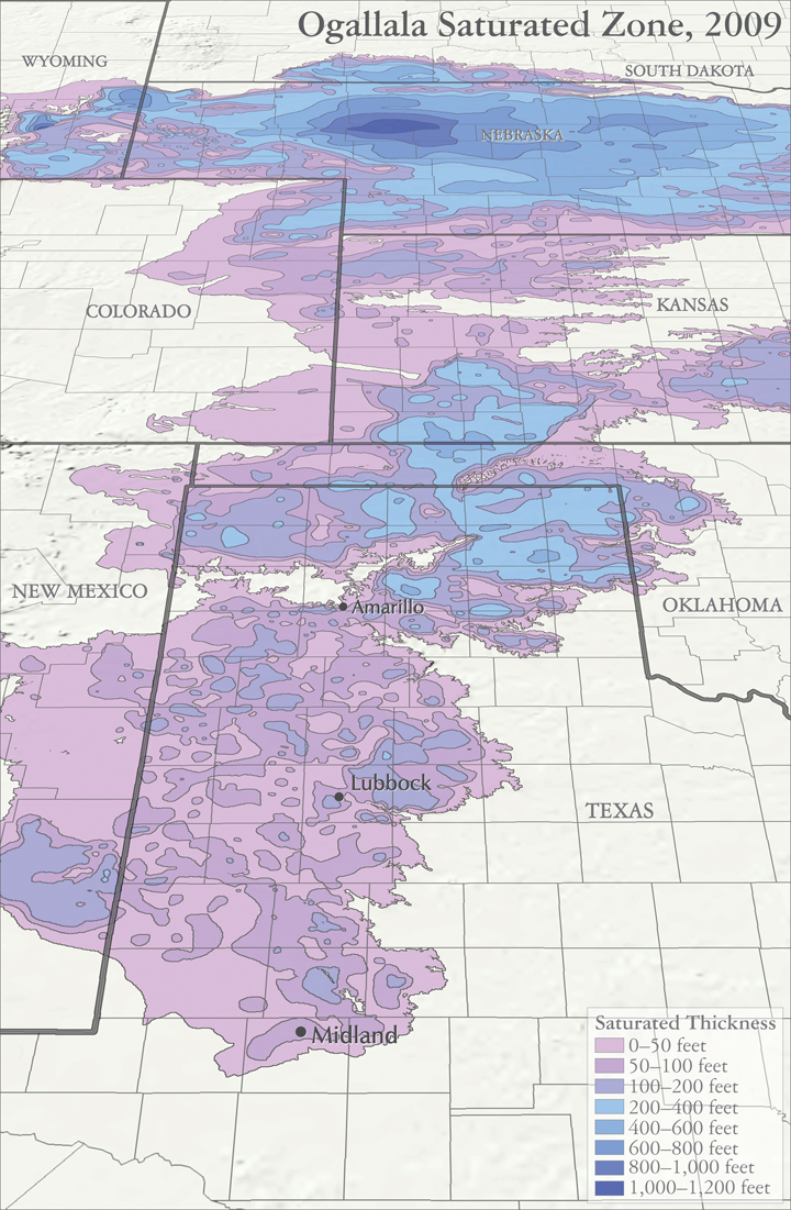
Map sources: Houston, Natalie. 2011. Hydrogeologist, Texas Water Science Center, U.S. Geological Survey. Personal communication, October 2011. Houston, Natalie, Amanda Garcia, and Eric Strom. 2003. Selected Hydrogeologic Datasets for the Ogallala Aquifer, Texas. Open File Report 2003-296. August 2003.
Texas manages groundwater with the Rule of Capture. The groundwater belongs to the landowner without a defined limit. It’s sometimes known as the Law of the Biggest Pump.
Colorado and Kansas water law is based on prior appropriation, known as First in Time, First in Right. A water right owner can pump their permitted amount if it doesn’t impair a more senior right – a water right that was established earlier in time. When there isn’t enough water to meet all needs, the owners of senior water rights have priority. The priority system works well for streams. When stream flow is low, it is generally clear which upstream, junior users must be cut off to protect the more senior water rights.
For groundwater, it is more complex to identify which water wells are impairing a more senior water well. Groundwater often provides a baseflow to streams; when heavy groundwater pumping lowers the water table so there is no longer a connection to the stream and stream flow declines, is that impairment?
Colorado state law dealt with such concerns by defining “designated groundwater basins,” those in which groundwater contributes little to stream flow. The Ogallala aquifer lies in designated groundwater basins. This allows more groundwater to be pumped, which lowers the water table, but with less risk of impairing surface water rights.
In Kansas, action is taken when a junior water right well’s pumping directly impairs a senior water right well, whether it uses groundwater or surface water. However, no action is taken if problems are due to regional groundwater declines. Like Colorado, Kansas allows the decline of the Ogallala aquifer to get the economic benefit from the water.
Management of the Ogallala aquifer is a balance between protecting existing water right holders and conserving water for the future. Attitudes change over time on what is a proper balance. Much water law encouraged development of the aquifer and protects current users. Is that balance shifting more toward conserving and extending this resource further into the future?
FromThe High Country News (Elizabeth Shogren) via The Colorado Independent:
Just a few days in office, the new administrator of the Environmental Protection Agency hosted an early Sunday morning breakfast for 11 Western governors. Scott Pruitt told them face-to-face what he’s said repeatedly since he was nominated: Under his leadership, the EPA will defer to states much more than it has in the recent past.
Pruitt made a similar vow to profoundly transform the agency the day before at the Conservative Political Action Conference (CPAC). “We’re going to once again pay attention to the states across this country,” Pruitt told a gathering of Republicans. “The future ain’t what it used to be at the EPA.”
This message resonated with the Western governors, regardless of their political affiliations, according to several members of the governors’ staffs. Alaska Gov. Bill Walker, a Republican-turned-Independent whose state is 66 percent federal land, was “encouraged by (Pruitt’s) emphasis on state’s rights,” Grace Jang, Walker’s communications director, says.
The Western governors’ unanimity is striking in an era of intense partisanship and reflects the commitment they have to work together through the Western Governors’ Association. The breakfast was an annual event of that group, a rare hub of bipartisanship and consensus building in a polarized nation. The governors are in the midst of a major effort to transform the relationship between the federal and state governments to give them more input into federal regulations.
“The Republican governors were on the same page with their Democratic colleagues in telling Pruitt, we want it to be a partnership,” says John Swartout, senior policy advisor to Colorado Governor John Hickenlooper, a Democrat. “We haven’t been happy that the EPA hasn’t always treated us as a full partner. We can make progress together.”
As they ate scrambled eggs, bacon, fried potatoes and donuts at a square table in EPA’s Washington, DC, headquarters, the governors one-by-one told Pruitt their priorities. Over the course of two hours, many mentioned their desire to have more sway over federal environmental regulations.
Western governors have collaborated for about 100 years. Their desire to present a unified voice to Washington is driven in part because of the vast amount of federal land in the West, which means decisions made in Washington have acute impacts on their states’ economies. “It’s largely a function of being so distant from Washington and needing to amplify their distant voices,” said Jim Ogsbury, executive director of the group.
In the Western Governors’ Association, the governors focus on shared objectives and pass joint resolutions. In December, for instance, they passed a resolution calling for a greater role in crafting federal regulations and in other decisions by the federal government. Other resolutions present their consensus positions on a wide range of issues, including endangered species, wildfire fire management, invasive species and abandoned mine cleanups.
Western governors from both parties felt the Obama administration’s EPA failed to adequately consult the states as it crafted some important environmental regulations, such as the 2015 Clean Water Rule. (That rule was temporarily blocked in 2015, pending resolution of a court challenge brought by industry groups and 31 states.) “Had the EPA worked with us on the rule upfront it could have been a better rule,” Swartout says. EPA did address some comments the governors made about how the proposed rule impinged on state authority over water management, but not all of them.
Just this week, President Donald Trump signed an executive order to launch a rollback of that rule and, until it’s rewritten, limit federal oversight to waterways that are navigable, leaving the rest to the states. Pruitt announced that he would rescind the Obama rule and write a new one that “restores the states’ important role in the regulation of water.”
“We believe (Pruitt’s EPA) will partner with states in a way that’s meaningful; in a way that quite frankly the previous administration did not,” says Nephi Cole, Wyoming Gov. Matt Mead’s policy advisor policy.
Many scholars caution that undoing that rule will be particularly detrimental in the arid West, where so many small streams and those that run only intermittently are crucially important for wildlife and water quality and quantity. States tend to be more responsive to local industries, because of the benefits they bring to the economy like jobs and tax revenue.
But Cole argues that it’s a “false narrative” to suggest that giving states more control equates to allowing more pollution and less environmental protection. In another resolution adopted in December, Western governors assert that they want to be the ones to decide how to balance the needs of industry in their states and the requirements of the Clean Water Act.
During the two-hour breakfast, Pruitt spent most of the time listening to governors. (Most years, the secretaries of Interior, Agriculture, Energy and other cabinet members important to Western states attend the breakfast, but as of Sunday, Pruitt was the only one of those who had been confirmed by the Senate.) Colorado Gov. John Hickenlooper urged Pruitt to personally engage in the Gold King Mine controversy. A 2015 blowout at the mine unleashed a surge of acid mine drainage down the Animas River. Pruitt committed to visiting Colorado and meeting with local and state officials, Swartout says.
A big priority for some governors is that the EPA continues to negotiate settlements with companies responsible for creating toxic waste sites covered under Superfund.
Oregon Gov. Kate Brown, a Democrat, urged Pruitt to move forward with the plan to clean up the Portland Harbor, a Superfund site, so the city can revitalize the waterfront and create jobs. She also stressed her state’s continued commitment to fighting climate change, according to her press secretary, Bryan Hockaday.
Montana Gov. Steve Bullock, who heads the Western Governors’ Association, wants Pruitt to keep the pressure on to finally reach a settlement on the Superfund sites in and around Butte, Montana, where historic copper mining and smelting left behind the nation’s largest toxic waste site, according to his press secretary, Marissa Perry. After many years, negotiations between the EPA and Atlantic Richfield Corporation, owned by BP, have picked up steam. Bullock wants to make sure the momentum isn’t lost.
While the Western governors break out of the hyper-partisanship that’s plagued other branches of government and see some opportunity to work with Pruitt, potential major budget cuts to the EPA may give Pruitt a lot less leeway to respond to state needs.
This week, the White House sent agencies an outline of the president’s draft budget that reportedly would gut the EPA’s $8 billion budget, cutting by 30 percent the grants it sends to the states to implement air, water and toxic waste regulations. Pruitt told E&E News that he’s asking the White House to retain more funding for the states to improve air quality, clean up Superfund sites and improve aging water and wastewater infrastructure. Programs slated for zero funding include grants to clean up abandoned industrial sites and funding to bring safe drinking water and sewer systems to Native villages in Alaska, according to the Washington Post. More details on the budget are expected later this month. It’s not clear if the White House can win approval for its vision of a much smaller EPA.
The proof of whether the governors and Pruitt will be able to work together will emerge in coming months, as the Trump administration pursues its agenda and rolls back existing rules. “We’re trying to work with him. We need to work with the federal government,” Swartout says. “It’s too early to know. We have to see how it all plays out. It’s just speculation at this point.”
Correspondent Elizabeth Shogren writes HCN’s DC Dispatches from Washington. This story originally appeared in High Country News on March 3, 2017.
As of March 2, the South Platte River Basin snowpack, which supplies much of Fort Collins’ water, sat at 131 percent of average for this time of year, according to the Natural Resources Conservation Service.
Statewide snowpack is at a robust 139 percent of the average.
Deep snowpack levels are important for Northern Colorado communities that rely on snowmelt for urban water supply, agricultural irrigation and spring and summer streamflows. Snowpack is especially important during times of drought, and Fort Collins has been in a drought since August…
By Nov. 17, 2016, Colorado’s water year was off to the worst start in more than three decades as a stubborn high-pressure ridge remained camped out over the northern mountains and foothills. Snowpack in the South Platte River Basin was about half of the average amount.
But then the high-pressure ridge began to break down, allowing the jet stream to meander into Colorado’s mountains and fill them to and in some places over the brim with snow. Several snowstorms have dropped 5 to 8 feet of snow since mid-November. The statewide rate of snowpack accumulation between Nov. 17 to Jan. 1 was the fastest Colorado has seen in 32 years, according to NRCS.
Snowpack generally peaks around the end of April, so there’s plenty of time for the current levels to change…
Meanwhile, Fort Collins is behind on snow but ahead on precipitation. February brought 4 inches of snow to the city compared to an average of 6.9 inches, according to 1981-2010 averages from the Colorado Climate Center. Since November, Fort Collins has received about 26 inches of snow compared to an average of about 32 inches.
The city is slightly ahead on precipitation, with 2.36 inches compared to an average of 2.06 inches.
Still, the National Weather Service’s Climate Prediction Center projects that Fort Collins’ moderate drought will persist through spring.
…some garlic and chili farmers of the Arkansas River Valley are battling a proposed state-backed gravel mine east of Pueblo that threatens to drive them away.
The farmers for 16 years have defended their fields against the mine on adjacent state-owned land up the hill. They contend gravel mining would destroy prairie needed to sustain pollinators, disrupt production with dust from noisy trucks, and foul their 1874 Bessemer Ditch with sediment that clogs irrigation sprinklers. They asked Gov. John Hickenlooper to intervene.
But last week, Colorado’s land board and the state mining board rejected the farmers’ appeals.
The conflict shows how, despite wide political support for the idea of saving farming amid a Front Range development boom, state agencies cannot easily make that happen. The State Land Board is required to lease state land to maximize revenue for schools. The mining board has limited discretion in granting permits for extraction of minerals, including gravel needed for urban expansion.
“This is the best farmland in the state of Colorado. We’ve already had deterioration of our agricultural base in the area due to water rights sales. We need to protect as much as we have left for future generations,” said Dan Hobbs, a Rocky Mountain Farmers Union organizer who has been growing crops on a 30-acre farm in Avondale for 17 years.
He grows high-value niche crops, including garlic and the chilis for which Pueblo is famous, and develops drought-resistant seeds. If the gravel mine is approved, with a planned road 41 feet from his property, Hobbs said he might have to leave.
“I’d be looking at some really hard decisions as to whether I could stay in that community, “ he said.
“We’d like the governor to protect our food-shed,” Hobbs said. “People in Colorado value food produced in Colorado and we want to continue producing it for them. This gravel mine would be too close to our irrigation systems and land.”
The battle over Cañon City-based Fremont Paving and Redi Mix’s proposal to mine gravel has intensified. Some farmers along the Bessemer Ditch, upstream from where the gravel mining would be done, have sold easements giving Fremont access across their land.
Mining would mean digging in and scooping out rock from under the Badger Hills, rolling prairie “uplands” above the river that serve as habitat for bees, birds, foxes and other wildlife.
Pueblo County authorities, who in 2001 and 2012 rejected the mine because of incompatibility in that agricultural area, must decide again — now that state agencies have signed off. County planners have scheduled a meeting April 5.
This time, the commissioners haven’t taken a position, spokeswoman Paris Carmichael said. “Agriculture is a huge part of our economy. It is vital to the Pueblo County economy and culture. We also encourage economic development and businesses being able to grow.”
The State Land Board is “an asset leasing agency that is responsible for stewarding state trust land on behalf of trust beneficiaries,” board spokeswoman Kristin Kemp said. Gravel mining would pay the board an estimated $1.8 million over 15 years, money that would help fund education.
Colorado’s six-member Mined Land Reclamation Board in January granted Fremont a permit. The board has issued permits for 1,290 construction materials mines around the state — mostly sand and gravel mines — state natural resources spokesman Todd Hartman said…
Beyond the prairie, the push to mine gravel is fragmenting longstanding farming communities.
“That’s the biggest tragedy, dividing the community, dividing the ditch company,” said Jay Winner, director of the Lower Arkansas Valley Water Conservancy District, which tries to protect water for agriculture as cities assert claims.
At recent packed meetings, tensions boiled over and county officials ordered a timeout for a landowner to consider a compromise. A police report has been filed alleging company trespassing to deploy drones for measuring the landscape.
“Neighbor against neighbor is a bad thing. You have school districts involved. Everybody and their brother is involved in this thing. People are taking sides,” Winner said. “There will be wounds because of this that will not heal for 100 years.”
“This gravel pit issue is about the future. It is about fairness,” he said. “And it is about whether farmers can continue to farm.”
The Forests to Faucets partnership originally began in 2010 as a response to a series of wildfires, namely the 1996 Buffalo Creek and 2002 Hayman wildfires. Since its inception, the partnership’s goals have grown to not only reduce catastrophic wildfires, but to also restore forests impacted by reservoirs, erosion and beetle devastation. On Monday, Feb 27, Forests to Faucets was granted a $33 million extension to continue its ongoing projects.
Lawrence Lujan is the regional press officer for the Rocky Mountain Region of the U.S. Forest Service, one of the organizations involved in the partnership. He says the specific strategies will be identified in a 5-year plan.
“Some of the tools in the toolbox include, thinning, prescribed fire, replanting trees, especially in areas that have been impacted by previous fires,” said Lujan. “We’ll be decommissioning roads, taking actions to minimize erosion and sedimentation of reservoirs.”
Locations for forest restoration and wildfire fuels reduction projects include Dillon, Strontia Springs, Gross, Antero, Eleven Mile Canyon, Cheesman and Williams Fork reservoirs. The partnership anticipates treating more than 40,000 acres of land…
The $33 million investment comes from an initial $16.5 million from Denver Water, targeting critical watersheds. Of that, the U.S. Forest Service will receive $11.5 million, the CSFS will receive $3 million and the NRCS will receive $2 million. Each entity will match Denver Water’s funding, for a total of $33 million.
Coyote Gulch at graduation March 4, 2017. @ClimateReality #ActOnClimate
Well you know they’ve been here once before
They wore the same old heavy coats
They seek no fortune, seek no fame
Just a few wild horses to tame — Spinning (Elephant Revival)
I made it through all 3 days of training.
If you get a chance to go to a presentation by a Climate Reality Corps speaker you owe it your self to go. Take your kids, take your grandkids, take your mom and dad, take everyone else you can think of. We have a great story to tell. It is possible to slow down the warming if we take action now along with the rest of the world. Renewable technology has surprised everyone. Setting out a fossil fuel free future is a win-win for everyone and all species and that’s worth your time.
The earth’s atmosphere and the setting sun, viewed from the Space Shuttle. Most of the Earth’s atmosphere is within 10 miles of the surface. (Source: NASA)
The flood of information and learning continued throughout the day on Friday. The training is focusing on three questions:
1. Do we need to act on climate change?
2. Can we act?
3. Will we act?
The answer to the first question is, yes, and urgent action is needed.
Question 2 is also a yes. The renewable energy revolution is upon us. Renewables are winning the economic battle along with the moral and ethical battle.
Question 3 is more problematic. Only the Republican party in the US is actively denying the science and the good news is that their opposition is fracturing. However, the world needs to accelerate the development of policies to halt the pollution of the atmosphere by greenhouse gases.
Vice President Gore went through a stripped down version of his slide show presentation with tips for all of us to use when we get the opportunity to speak to others about the climate crisis facing the world.
Gore also talked about the sequel to the film An Inconvenient Sequel: Truth to Power. It is slated for opening the weekend of July 28th. Here’s a teaser from YouTube:
During the afternoon we were coached on techniques for answering the tough questions about the climate crisis. This hit at the heart of why I’m attending. I want to learn how to communicate the existential threat of the climate crisis to folks with a different world view than mine.
I’m having a great time at the training. Look for more in-depth coverage of climate change from Coyote Gulch in the future.
Here’s a recap from Bruce Finley writing for The Denver Post:
…this 34th training — the first since Trump rose to power — drew 1,000 more applications than usual as 2,600 people from around the West vied for 972 slots in Denver.
Climate Reality leaders are vowing to fight Trump team measures from proposed EPA budget cuts to rule rollbacks “every step of the way” — including direct action tactics such as tent camps and consumer campaigns against financiers of new fossil fuel pipelines. They’re bracing for White House action expected this month against President Obama’s signature Clean Power Plan to cut U.S. carbon emissions.
“We are winning. We are going to win,” Gore said in an interview after the speech. “Large numbers of passionate grassroots activists can make all the difference.”
Heat-wave deaths and more extreme storms, combined with falling costs for clean energy, are forcing a shift off fossil fuels, Gore said.
“And this grassroots movement is advancing on multiple fronts,” he said. “The fastest growth is in interacting with elected officials, not only in the U.S. House of Representatives and U.S. Senate, but also city councils, county commissioners, state legislatures. There’s also an important branch of the activism that is focused on businesses…
Meanwhile in the convention center, Gore narrated his slide show, updated after midnight to include latest images of climate change impact around the world — such as a burning building floating in Maryland floodwaters just before crashing into a bridge.
He presented latest data from climate scientists during a past decade where average global temperatures repeatedly have set new records. And photos documents growing human health impacts with temperatures in some regions topping 120 degrees, up to a 165-degree record in Iran – evidence of a trend where authorities increasingly deem areas “uninhabitable.” One slide showed people collapsing as a street melted in India where government officials during a heat wave in 2015 reported 2,330 deaths, and another showed work crews in Pakistan last year digging graves in anticipation of more heat wave deaths.
The activists devoted hours to viewing and discussing wide impacts of climate change, including the recent wildfires and severe flooding in Colorado that scientists and government officials have linked to climate change.
Climate Reality runs offices in 10 nations outside the U.S. and will open an office in Mexico this year, president Ken Berlin said. “We oppose the pipelines like other groups yet have not been involved in the tent camps yet. We will consider that as we go along…. We are taking a look at the best ways to be effective through traditional political action. We want to do everything we can to protect climate change laws.”
The organizers of the training hailed signing of the international Paris Treaty last year as a huge step forward. Cities, businesses and universities around the United States made pledges to shift to cleaner, renewable sources for all the electricity they use. But organizers also acknowledged growing uncertainty about whether the U.S., a main source of the heat-trapping gases, will keep its commitments as part of that treaty.
“It would be a catastrophic setback for the climate movement, and for the world as a whole, if the United States did withdraw,” Gore said.
“There’s a big struggle under way within the Trump White House. … There’s still an excellent chance that, even if he tries to kill the Clean Power Plan, he will decide not to formally withdraw from the Paris Treaty. There’s hardly anything he could do that would create more ill will, diplomatic damage and friction between the U.S. and virtually every other country in the world than pulling out of the Paris Treaty.”
As EPA and other government employees dealing with environment issues worried about loss of momentum, the activists rallying in Denver through Saturday exuded a mostly hopeful determination despite a dizzying deluge of heavy information.
“Most of this can still be stopped,” Gore told them after looking at time-lapse images of arctic glaciers melting and collapsing into a rapidly-warming ocean.
“This is reality. We have to take it out of the partisan framework. That is insane,” he said.
“We have to change. Can we change? If we have to change and we don’t have the ability to change, I don’t want to hear anything more about it because that is just a recipe for anxiety and stress. … Yes, we can change.”
“Every major city gets water out of this basin. 40 million people, seven states, two nations, 22 federally recognized Indian tribes — everybody depends on it,” said Brad Udall, senior water and climate research scientist at Colorado State University.
According to a new study by Udall and Jonathan Overpeck, a climatologist at the University of Arizona, this essential river is seeing its water levels drop due to climate change.
The researchers contrasted the most recent drought on the river — from 2000 to 2014 — with another one from the mid-1950s to about 1967. The earlier drought’s primary cause was a sharp fall in precipitation. In the most recent drought, however, the primary factor was heat.
“Since 2000, the Colorado River has been in a drought. The flows are down about 20 percent. We say that about a third of that reduction is due to the higher temperatures that we are now experiencing in the 21st century,” Udall said.
Since 2000, temperatures have risen on average 1.6 degrees Fahrenheit above normal in the Upper Colorado River Basin annually. Udall and Overpeck found that the hotter weather stripped the river of at least 500,000 acre-feet of water. That’s enough water for half a million families of four for a year according to the U.S. Bureau of Reclamation.
Where is the water going? Into the atmosphere, ecosystem and human consumption and agriculture.
“We now have snowmelt two to three weeks earlier, so you have a longer period of time for plants to use water, you have hotter conditions so the plants use more water and the atmosphere as the climate warms demands more water. It’s a bigger suck, if you will, for moisture,” Udall said.
The researchers predict that as weather continues to warm over the next three decades, the water in the Colorado River will decline by about a quarter. That would be a dramatic impact on a river that supplies water to 40 million people in seven western states, including Colorado. By the end of this century, the river could drop by more than half, far more than federal water managers have predicted.
But some scientists aren’t so sure.
“So this is my question: is this drought, are we going to recover, is it climate change and we’re not going to recover, how much of each — the paper doesn’t quite address that. It certainly doesn’t do the science to get at the bottom of it,” said Martin Hoerling, a research meteorologist specializing in climate dynamics at NOAA’s Earth System Research Laboratory in Boulder, Colorado. He was not involved in the study.
“That’s a big deal. Now, I’m saying this like it’s a certainty — it’s not. But the aggregate, the average, of all the models do indicate a wetter climate,” Hoerling said. “Why? Well it may simply be the water vapor content is going to be more abundant, so when storms come they will be able to bear more moisture and when they drop that moisture there will be more snowpack as a result in the core of winter in the upper Colorado River Basin. That effect is enough to compensate for most of the warming.”
Lake Mead from Hoover Dam December 13, 2016.
Water experts say that if the ongoing drought persists, Lake Powell could be empty within three years, and call could be placed on the upper basin to curtail water rights. To avoid the chaos such an unprecedented call might bring, state officials are discussing how a more orderly, but still mandatory curtailment of water uses, might need to be implemented. A wall bleached, and stained, in Lake Powell. Photo credit Brent Gardner-Smith @AspenJournalism.
Colorado River headwaters tributary in Rocky Mountain National Park photo via Greg Hobbs.
Upper Basin States vs. Lower Basin circa 1925 via CSU Water Resources Archives
President Donald Trump has directed the Environmental Protection Agency to roll back a clean water regulation that Colorado ranchers have criticized as overly burdensome but environmentalists and outdoor enthusiasts say is essential to protecting the health of the state’s rivers and streams.
Trump’s executive order Tuesday concerns what is known as the Waters of the United States rule, a regulation passed in May 2015 under President Barack Obama that clarified the scope of waters protected under the 1972 Clean Water Act. Calling Obama’s expanded regulations “a disaster” and “one of the worst examples of federal regulation,” Trump said his order was “paving the way for the elimination” of the rule, which had yet to be implemented.
Obama’s rule set about clarifying which U.S. waters are protected from pollution under the Clean Water Act. Until 2015, the Act protected “navigable waters, interstate waters and the territorial sea” and also, on a case-by-case basis, waters that were upstream given that protecting major waterways requires looking after what flows into them. Obama’s rule expanded protections to include most tributaries, wetlands near floodplains and even some “isolated” waters — those that don’t actually flow into protected waters, but are near them.
Trump’s order seeks to scale back this definition to be more in line with an opinion issued by the late U.S. Supreme Court Justice Antonin Scalia in a 2006 case about the Clean Water Act. In ruling that Clean Water Act protections did not extend to a particular wetland, Scalia defined protected waters as “relatively permanent, standing or continuously flowing bodies of water.” Obama’s rule, in contrast, relied more heavily on the definition presented in Justice Anthony Kennedy’s concurring opinion. The Supreme Court could not reach a majority on that case, ruling 4-1-4.
Rob Harris, a senior attorney at Western Resource Advocates, says that under Scalia’s definition, impermanent and seasonal streams and waterways, such as those that rely on snowmelt or are particularly vulnerable to drought, may not be protected. That poses a particular threat in Colorado because, Harris says, only 15 miles of Colorado rivers and streams are what might be considered traditionally navigable waters. “The other 95,000 stream miles are not,” he said.
Trump said he was signing the order on behalf of farmers, ranchers and agricultural workers, who find the rule overly burdensome. “It’s prohibiting them from being allowed to do what they’re supposed to be doing,” he said, adding that the Waters of the U.S. rule applies to “nearly every puddle or every ditch on a farmer’s land, or anyplace else that they decide.” As an example, Trump said, “If you want to build a new home, for example, you have to worry about getting hit with a huge fine if you fill in as much as a puddle — just a puddle — on your lot.”
But that’s not true. The rule, in fact, clarified that the Clean Water Act does not apply to puddles, nor to groundwater, artificial ponds and lakes, artificial dryland irrigation or to many kinds of ditches. Trump’s remarks upon signing the rule, saying that “In one case in a Wyoming, a rancher was fined $37,000 a day by the EPA for digging a small watering hole for his cattle” and that “I’ve been hearing about it for years and years” could not have been as a result of the Waters in the U.S. rule, which, again, had not yet gone into effect.
Still, farmers and ranchers said the rule was unclear about what agricultural-related waters were included. They worried, as Politico reported, that the rule would “give bureaucrats carte blanche to swoop in and penalize landowners every time a cow walks through a ditch.”
“We wanted to see the rule rescinded. We asked that it be reconsidered,” said Terry Fankhauser, the executive vice president of the Colorado Cattlemen’s Association which contributed funds to a lawsuit filed by a national cattlemen’s association and several commodities groups challenging the Obama administration’s expanded definition of which bodies of water should be protected.
Fankhauser said groups like his worked with the Environmental Protection Agency to try to find answers, but remained unclear about what enforcement might look like. He thought the best answer would be to redefine the terms and reconsider the rule itself before finalizing it.
Environmentalists worry that Trump’s order will hurt Colorado’s water quality and wildlife by narrowing which waterways receive protection from pollution. “The people of the American West want clean, healthy rivers, not a return to the days when rivers in America caught fire and were severely polluted and dead,” Gary Wockner, director of Save The Colorado, said in a statement. The way he sees it, basing water protections on Scalia’s definition could leave the Poudre River, the South Platte River and rivers across the Front Range vulnerable to pollution not just from agriculture, but from coal-fired power plants, refineries and even city wastewater treatment facilities.
Sportsmen, too, are concerned about the environmental effects of the order. David Nickum, the executive director of Colorado Trout Unlimited, said that anglers know clean water starts at the source. “If we degrade and pollute those headwaters, it is only a matter of time until the next snowmelt or rainstorm sends those impacts down into our larger rivers and water supplies.” Chris Wood, the CEO of Trout Unlimited, said that altering the rule to follow Scalia’s definition would cause 60 percent of U.S. streams and 20 million acres of wetlands would lose protection of the Clean Water Act. That would be, he said, “an unmitigated disaster for fish and wildlife, hunting and fishing, and clean water.”
But Fankhauser insists that clean water matters to cattlemen, too — “it’s not only a right, it’s an obligation to us” — and said calling Trump’s order a rollback of the Clean Water Act was a “pretty significant overstatement.” Rather, he says, it’s an opportunity to come up with a solution that protects the environment without strapping the agricultural sector with unnecessary regulations.
Trump can’t simply undo Obama-era water quality protections with his executive order. His EPA chief Scott Pruitt will have to undergo a lengthy federal rulemaking process to repeal the Waters of the U.S. rule. And, as Vox reports, federal courts have historically interpreted the rule as Kennedy did, rather than along Scalia’s narrower view. [ed. emphasis mine]
Colorado, in the meantime, has the ability to enact more stringent water regulations. Harris, who hopes either the state legislature or the Colorado Department of Public Health (CDPHE) will take on the task, wondered, “Are we going to wait until something bad happens and our waterways are impacted, or are we going to protect our waterways before the problem even starts?”
Jacque Montgomery, spokesperson for Gov. John Hickenlooper, says the administration wasn’t completely satisfied with the Waters of the U.S. rule, but that “the complete absence of a rule means ambiguity and uncertainty” regarding which waters apply. Said Montgomery, “Colorado aims to keep protecting our watersheds and streams,” and will follow through on the watershed and stream management plans called for in the state water plan. Her remarks, says CDPHE spokesman Mark Salley, speak for that organization as well.
Trout Unlimited’s Nickum predicted a lengthy battle in Colorado from groups looking to push against what they see as a threat to their clean water.
“You can expect Colorado sportsmen and women to be aggressively involved, fighting for the headwater streams and wetlands that are essential for healthy fish and wildlife habitat,” he said.
I’m heading to the Colorado Convention Center for a 3-day training with the Climate Reality Project. I’m hoping to learn techniques for communicating with folks that have differing world views from mine.
Posting may be hit-or-miss through Saturday. I’ll try to catch up on Sunday and Monday.