#Utah is embarking on planning effort for the sustainability of the #GreenRiver and the #ColoradoRiver #COriver

From The Deseret News (Amy Joi O’Donoghue):

The plans affect those state-owned sovereign land sections of the rivers as they go through Uintah, Grand, Emery, Wayne, Garfield, Kane and San Juan counties. The beds of navigable waters are owned by the state but held in trust for the public.

Plans will be developed, with public input, under the purview of the Utah Department of Natural Resources’ Division of Forestry, Fire and State Lands.

That division is required to regulate all uses on, beneath or above the bed of the rivers, including protecting navigation, fish and wildlife habitat, aquatic beauty, public recreation and water quality.

These first-ever comprehensive management plans will also include an update of mineral leasing plans impacting Green and Colorado river resources.

During March and April, the division — assisted by contractors SWCA Environmental Consultants; CRSA architects, planning and design; and Hansen, Allen & Luce — will present information regarding the plan development process at open house meetings in each county that contains state-owned sovereign land sections of the rivers.

The open houses, all from 6 to 8 p.m., are as follows:

• Uintah County, March 27, at the Uintah County Library in Vernal

• Kane County, April 10, at the Kanab City Library in Kanab

• Garfield County April 11, at the Escalante Senior Center in Escalante

• Wayne County, April 12, at the Hanksville EMS Building in Hanksville

• San Juan County, April 17, at the San Juan County Administration Building in Monticello

• Grand County, April 18, at the Grand County High School Auditorium in Moab

• Emery County, April 19, at the John Wesley Powell Museum in Green River

All residents are encouraged to attend the public open house meeting in their county.

“Public involvement is an important part of the Green and Colorado river planning process,” said project manager Laura Vernon, adding “suggestions and concerns about the rivers can help us identify issues and develop management plan objectives.”

#Snowpack news: @NorthernWater to set C-BT quota on April 12th

Westwide SNOTEL basin-filled map March 17, 2018 via the NRCS.

From The Fence Post (Nikki Work):

As of March 14, the state sits at about 67 percent of the average snowpack, according to the Natural Resources Conservation Service.

Things are looking slightly better in northern Colorado, with the two basins that impact Weld County — the Upper Colorado and the South Platte — at 77 percent and 81 percent of the average year, respectively…

Eric Brown, spokesperson for the Northern Colorado Water Conservancy District, said the dry weather is on Northern Water’s radar, just like it’s on farmers’, but there may be one saving grace — a healthy amount of water in reservoir storage.

Northern Water’s reservoirs are at one of their highest ever levels, with storage at 121 percent of average. Across Colorado, reservoir storage is at about 117 percent of the historic average. While Brown said the water district is optimistic that, in true Colorado fashion, there’s a big spring storm a’comin’, its prepared to use some of its reserves to combat an abnormally dry year.

“In general, farmers who have access to some sort of water in storage should be okay for 2018, as Northern Water’s C-BT Project and reservoirs across the South Platte Basin are sitting at solid levels for the most part,” Brown said. “But for the farmers who don’t have access to water that’s in storage, they really need snow and/or spring rains in the near future.”

But for everyone, use of the water in storage this year creates uncertainties down the road, as some of the current surplus will be used up. Plus, a good, wet snow would bring some much-needed moisture to the plains and help with soil quality, which plays an important role in crop health.

The Northern Water Board will set its quota for C-BT deliveries for the remainder of the 2018 water delivery season at its April 12 board meeting. Both snowpack and C-BT and local non-C-BT reservoir levels will factor into this decision. The board sets a quota each year to balance how much water can be used and how much water needs to stay in storage, and the historic average for the quota is 70 percent.

Colorado-Big Thompson Project Map via Northern Water

2018 #COleg: HB18-1008 Mussel-free Colorado Act status update

Photo via Colorado Parks and Wildlife.

From The Summit Daily (Deepan Dutta):

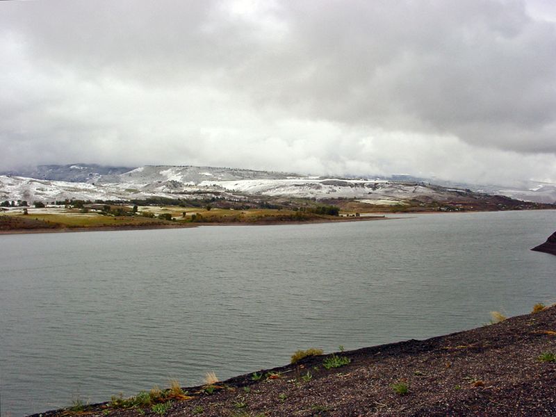
Should the non-native quaggas infest the [Green Mountain Reservoir], millions in taxpayer money will be spent to ensure they do not clog or damage water infrastructure, as well as to prevent destruction of the aquatic ecosystem and the associated recreational fishing industry.

The danger posed by this critter is so high that Colorado Parks and Wildlife, the U.S. Forest Service, the Bureau of Reclamation, Summit County and other agencies are combining efforts to make sure the quagga does not wind up ruining the reservoir as it has other water bodies in Colorado.

Legislatively, a bill called the “Mussel-Free Colorado Act” dedicated to eradicating quagga and zebra mussels is well on its way to becoming state law. The bill requires boat owners to purchase an aquatic invasive species sticker on top of their regular boat registration to fund mussel prevention measures.

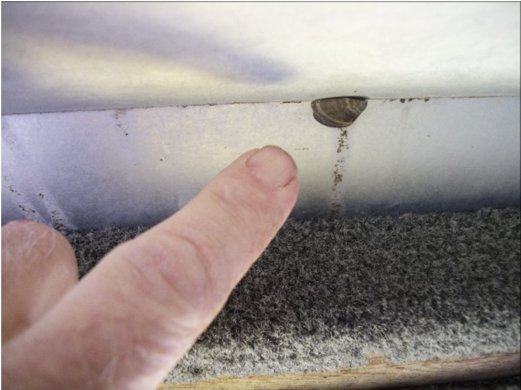
County Commissioner Karn Stiegelmeier has been following developments at the reservoir intently since last August, when the Bureau of Reclamation discovered quagga veliger, or larvae, in the reservoir. At the time, Stiegelmeier said she was furious with the lack of federal funding to pay for boat inspections preventing mussel infestation in the first place.

“Other reservoirs like Dillon Dam and Wolford are taken care of by the responsible dam owners,” Stiegelmeier said. “They pay for regular boat inspections before they get in the water, as they should. But the federal government reservoirs always contract out recreation and claim it’s not their job to making sure boats aren’t contaminated before they launch.”

DECONTAMINATION

Federal authorities were put on high alert and finally turned their attention to Green Mountain once mussel larvae was detected. Stiegelmeier said that it will be a much more expensive endeavor to try to ward off infestation after it starts.

“Once a reservoir is infested, the feds wind up having to pay many times as much to deal with the infestation,” she said. “Once the adult mussels get in there you can’t get rid of them. We have a huge number of reservoirs, like Lake Powell, that are infested. It costs an enormous amount of money to get mussels off the dam infrastructure, and it absolutely destroys the aquatic ecosystem.”

While samples at Green Mountain have come back clean since the initial detection, Bill Jackson, head of the U.S. Forest Service’s Dillon Ranger District, said that concern over quagga is far from over…

Jackson said that to prevent the infestation, the Forest Service and other agencies will monitor water at Green Mountain for at least three years — the maximum amount of time quagga need to fully develop. The agencies are also working to divert all incoming boat traffic to a single launch point at Heeney Marina, where they can be centrally inspected and decontaminated before reaching the water. Jackson said that one major risk factor for contamination was how many boats were previously launched from unauthorized areas along the shoreline.

“We had a lot of motorboat launches into the reservoir without proper inspection and decontamination,” Jackson said. “We’ve really been trying to make sure that we got on that right away to prevent folks from doing that.”

Jackson said that the Northern Colorado Water Conservancy District, which gets some of the water from the reservoir, helped in providing rocks, boulders and other implements to block off the known boat entry points. He also said that signage will be put around the reservoir directing boat owners to proper launch points where they will be inspected and decontaminated before hitting the water.

In the months leading to boating season, Jackson said that a major collaborative project will be taking place to improve the inspection and decontamination process at Green Mountain.

The Bureau of Reclamation and other partners will help Heeney Marina to improve its boat launch facilities and parking to accommodate the large amount of boat traffic being funneled there. The Forest Service will do its part by allowing modifications to the marina’s permit for construction there, as it operates on Forest Service land.

The project will also require Summit County to help by closing down and improving the county roads leading into and out of the reservoir, as well as introducing more signage. Details of the project have yet to be released in full to the public, but Jackson said a press release is forthcoming.

Jackson added that they needed the public’s help in preventing contamination.

“If folks are not getting their boats inspected, that doesn’t help anyone, and we wind up dealing with the aftermath of cleanup efforts. Prevention is where we want to be.”

Jackson said that boat owners can help by following a three part procedure: Clean, drain and dry.

Click here to view the list of the West’s worst invasive species according to the Western Governors’ Association.

#Nebraska: Platte River to Republican River compliance transbasin diversion in the plans

From the Associated Press via ARGUS-Press.com:

The plan is to divert excess Platte water via canal, culvert and pipeline over the Platte-Republican divide near Smithfield in south-central Nebraska’s Gosper County and run it south into the Republican via Turkey Creek, the Omaha World-Herald reported.

The 25-mile-long stream is a tributary of the Republican starting about 3 miles west of Smithfield. It empties into the Republican between Edison and Oxford. The Republican River rises in Colorado and crosses southern Nebraska before flowing into Kansas.

The primary objective is to help ensure the state’s compliance with an interstate compact that allocates certain percentages of the Republican River’s flows to Nebraska, Kansas and Colorado, said John Thorburn, general manager of the Tri-Basin Natural Resources District in Holdrege. Although the states have been working in harmony on managing the river in recent years, disputes among the three have escalated to the U.S. Supreme Court.
After three years of active planning, project proponents submitted their initial permit paperwork to the Nebraska Department of Natural Resources last week.

Tri-Basin partnered with the Alma-based Lower Republican NRD to develop the $1.4 million to $1.9 million enterprise known as the Platte Republican Diversion Project. It would tap Platte water from a canal owned by the Holdrege-based Central Nebraska Public Power and Irrigation District. The district stores North Platte River water in Lake McConaughy in western Nebraska and delivers it downstream and into canals for delivery to farmers to irrigate cropland.

“This is precedent-setting for Nebraska,” Thorburn said. “We’d be taking otherwise ‘wasted’ water to be put to good use for a beneficial purpose.”
Thorburn and others expect resistance from environmental organizations that have raised concerns, saying there really isn’t extra water in the Platte and that it’s all precious in providing habitat for endangered bird species, including the whooping crane, piping plover and least tern.

The Platte’s floodwater — the excess flows that would be diverted at times — scrubs trees and other vegetation from sand bars and other important habitat for sandhill cranes. Downstream near Lincoln and Omaha, the river replenishes aquifers and well fields providing drinking water to the state’s two largest cities.

The diversion would not occur during the June-through-August irrigation season, Thorburn said.
The potential economic impact of the project in the Republican basin would range from $14.2 million to $33 million, depending on how much of the water required to meet interstate agreements and obligations comes from the diversion versus other sources, according to a study by the Bureau of Business Research at the University of Nebraska-Lincoln.

The Platte in central Nebraska is designated by the Natural Resources Department as over appropriated, meaning there is more demand for the water than the river can provide. It is the state’s only over appropriated river. Still, there are times when floods funnel high water down the river’s usually shallow channels.

An engineering study by Olsson Associates of Lincoln for the project partners indicated that under two scenarios a potential 57,000 to nearly 140,000 acre-feet of unallocated water could have been diverted from the Platte into the Republican during the period of 2013 to 2016. An acre-foot is the volume of water that would cover an acre of land 12 inches deep.

The peak scenario would require 100 cubic feet per second of water to flow down Turkey Creek at times. A cubic foot is like a box of water measuring one foot by one foot by one foot. It contains around 7½ gallons. This rate of flow is a bit less than the volume of water Omahans see in Big Papillion Creek at Q Street in a typical March.

Turkey Creek’s current base flow is about 12 cubic feet per second. Erosion-control measures and other improvements would allow the creek to handle diverted flows up to 100 cubic feet per second without damaging the surrounding land in Gosper and Furnas Counties, according to the engineering study. The draft application calls for diverting 275 cubic feet per second from the Platte in order to provide up to 100 cubic feet per second into Turkey Creek.