#ColoradoRiver: When rivers, or at least their remnants, return — Laura Paskus #COriver

La Ciénega de Santa Clara via YouTube

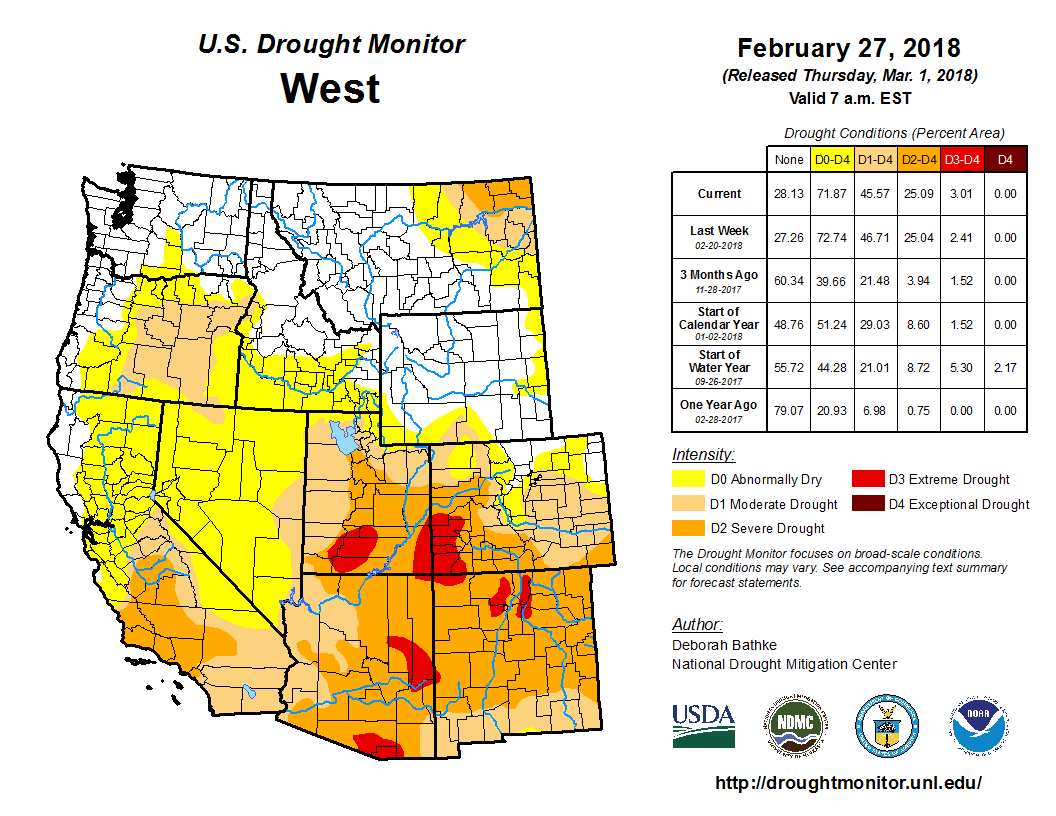
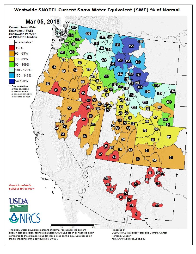
From the New Mexico Political Report (Laura Paskus):

Alejandra Calvo crosses a barren stretch of desert in Sonora, México almost daily during certain times of the year. The route could easily disappear beneath blowing dust and when rain does fall here, it renders the road impassable. There are no birds or wildlife here, not even any visible plants.

It wasn’t always like this: Until the 1960s, the Colorado River spread across this delta on its path to the Sea of Cortez.

Originally from Chiapas, Calvo is a biologist who works for ProNatura Noroeste, a conservation group based in northwestern Mexico. “Calvo is ‘bald’ in English,” she laughs, and tugs at her long blond hair spilling out from beneath her baseball cap. “That is not me.”

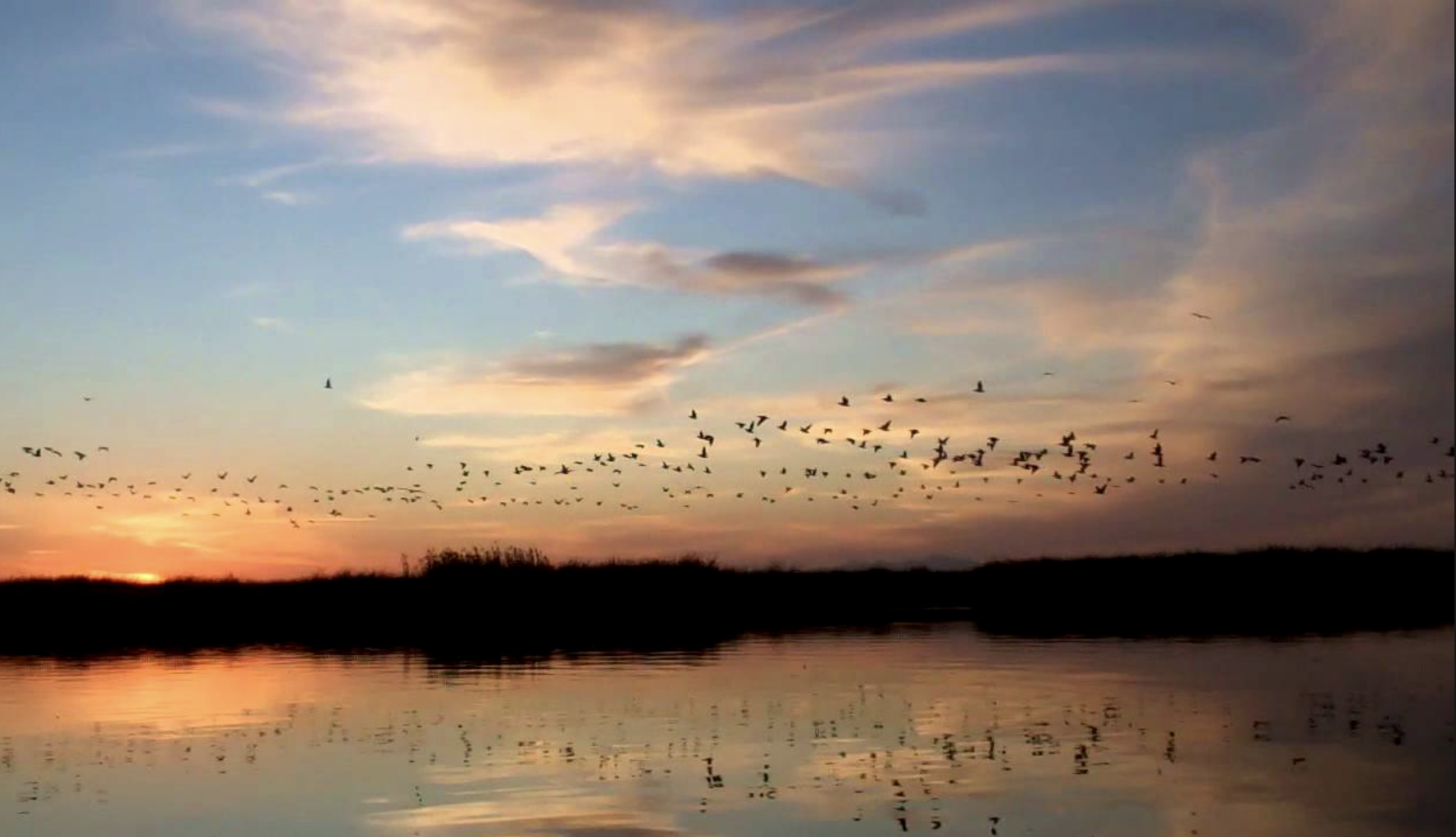
She drives this way to reach an unexpected wetland in the desert. About 30 miles south of San Luis Río Colorado—as the crow flies, not as the roads wind—lie 40,000 acres of salty lagoons and marshy wetlands. Shorebirds and migratory ducks and geese descend here by the tens-of-thousands. Migratory warblers and terns visit, as do rare birds like Yuma Clapper Rails and Piping Plovers.

La Ciénega de Santa Clara, the largest saltwater marsh in the Sonoran Desert, isn’t here because the ocean crept this far inland. Nor is it some remnant from when the Colorado River still reached the sea. Since the 1970s, a canal has dumped water too salty for farms here in the delta. For decades, the United States delivered water across the international border that included saline runoff from American farms. After a treaty amendment requiring the U.S. to reduce the salinity of its deliveries, that runoff was diverted to the Colorado River’s dry floodplain. And there grew La Ciénega de Santa Clara.

Today, as the motorboat passes between stands of cattails, American Coots squeak and flap off into the air. Calvo says families come out here during La Semana Santa, the Holy Week of Easter, and hunters and fishermen visit, too. But for the most part, it’s quiet.

The boat surprises two white pelicans, which lift off the water in a slow, heavy show of impatience. There are herons, too, and as the sun lowers in the winter sky, swallows swarm across the surface of the water, skimming up a drink. Back on shore, grackles hop across stands of saltbush, keeping a close eye on all that’s happening.

As cities and farmers in the United States, not to mention the warming climate, increase pressure on the Colorado River, the Yuma Desalting Plant is again looking like an attractive way to glean more water for Arizona. Built in 1992, the plant has only been operational twice. Were it running again, however, the ciénega would lose its water supply.

That has activists like Calvo, and the National Audubon Society’s Jennifer Pitt, worried. But there are also reasons for hope—here and upstream where Mexican and American activists have worked together on a restoration project in the Colorado River’s historic channel for about a decade.

Binational cooperation on the Colorado

About 40 miles from the ocean, Laguna Grande is the largest restoration site in the delta. The binational Sonoran Institute began work here on patches of existing habitat established when the river flowed through its channel in the late 1990s or early 2000s.

Soon, the project should cover about 800 acres, and it already employs more than 20 people, many of whom live in nearby villages. Families can visit the restoration project, and students come out to tour the newly re-established cottonwood forests. Beavers have returned here, as well as bobcats and coyotes. There are also rodents, raptors and rattlesnakes. The Sonoran Institute leases or buys water from farmers in the Mexicali Valley to support the wetlands, and the more than 250,000 trees they’ve planted here.

Walking through the cottonwood forest, Pitt says this landscape was destroyed before anyone figured out what to do about it. When the Colorado River started running dry in the mid-20th century, there weren’t yet environmental laws to temper or stop destructive operations or policies.

“We didn’t have a regulatory framework, we didn’t have courts, and we didn’t have any leverage,” Pitt says. “We figured that out at some point in the mid-2000s and figured out that as a conservation advocacy community our path forward had to be collaboration and cooperation. We had no choice.”

The United States and Mexico, as well as conservationists and stakeholders on both sides of the border, worked to bring a pulse of water through here in 2014, down the Colorado River to the Sea of Cortez—an initiative Pitt championed while working for the Environmental Defense Fund.

But whether talking about Laguna Grande or the pulse flow, Pitt is careful to note the delta is by no means fully restored. “When we say ‘restoration’…we mean there’s going to be a tiny, little ribbon of green that connects the Upper Gulf to the Colorado River,” she says. “That’s important. But that’s not the delta back again.”

#Snowpack/Drought news:

Click on a thumbnail graphic to view a gallery of snowpack data from the NRCS.

From The Vail Daily (Scott Miller):

The latest readings from the U.S. Department of Agriculture’s snow measurement sites at Vail Mountain, Copper Mountain and Fremont Pass show a mixed bag of “snow water equivalent.”

While Vail Mountain continues to have adequate snow for skiing and snowboarding, the measurement site continues to give below-average readings.

On Monday, March 5, the Vail Mountain site showed only 9.8 inches of snow water equivalent, below even the 12.5 inches recorded in the historic drought year of 2011-12. In that drought year, the snowpack at Vail Mountain peaked on Feb. 28 and then fell quickly. The Vail Mountain measurement site was melted off by April 8.

There’s better news from Copper Mountain — near the headwaters of Gore Creek — and Fremont Pass, near the Eagle River’s headwaters.

At Copper Mountain, the snow water equivalent is 79 percent of normal. The Fremont Pass site is right at the 30-year average…

UNCERTAIN OUTLOOK

We’re all hoping for more snow in the next several weeks, and it’s hard to tell just what those weeks will bring. Still, the outlook isn’t particularly promising.

Andrew Lyons, a meteorologist in the Grand Junction office of the National Weather Service, said the winter-long dry pattern seems to be holding.

An area of high pressure around the Southwestern United States and over the Pacific Ocean has been pushing storm systems to the north of Colorado all winter. That pressure ridge hasn’t moved much.

Lyons noted that we’re in the second year of a “La Nina” pattern — which develops due to cooler-than-average temperatures in the central Pacific. Those systems tend to bring more snow to Colorado resorts north of Interstate 70. Historically, though, the second year of La Nina patterns tend to be more dry than the first year.

Lyons said the current pattern has about run its course, which means the long-term outlook is uncertain.

The 90-day outlook from the U.S. Climate Prediction Center isn’t encouraging.

That forecast calls for a better-than-average chance of higher-than-normal temperatures and lower-than-normal precipitation.

Still, it’s springtime in Colorado. Just about anything can happen.

West Drought Monitor February 27, 2018.

From 9News.com (Core Reppenhagen):

Drought, low snowpack, and high fire danger.

These are three different ways to describe how dry it is in Colorado right now. Those three categories are closely related … but not the same.

Think of it like this: Drought shows a deficit of moisture in the ground and soils. Fire danger shows a deficit of moisture in the fuels, which is in the trees, the branches, and on the ground.

Snowpack, at least this year, shows a deficit of moisture in the bank.

Together, these three categories show a more detailed picture of just how dry Colorado really is this year.

Seventy one percent of Colorado is in drought conditions as of March 5. That’s the largest drought our state has seen since September 2013, just before the historic floods.

This drought data gets updated once a week, by the National Drought Mitigation Center. It’s not a computer model. It’s put together by a person who weighs precipitation data, field measurements and satellite scans to subjectively report current drought conditions.

Thirteen different authors take turns putting together the reports. These authors range from drought experts, climatologists, hydrologists, meteorologists and agriculture experts.

The product they put out is called the U.S. Drought Monitor, and it’s meant for use in agriculture, by water managers, by governments that might need to implement water restrictions, and for every citizen to get a general understanding for available water.

The author of this week;s report, Deborah Bathke, told 9NEWS that drought is not a direct representation of fire danger, although it is closely related. Both products are driven primarily by lack of precipitation.

Fire danger shows both current and future conditions. Many areas along the Front Range of Colorado are listed in high or very high fire danger right now. That is due to the low moisture content in ground fuels like grasses, and shrubs, and even larger fuels like large tree branches, and limbs.

The Fire Danger Outlook is a forecast. The latest data shows a higher likelihood of above average wildland fire activity for southern Colorado through May, but average fire activity for the rest of Colorado…

Snowpack in our state is at record low levels at 9 Snotel observation sites, and is at 2nd lowest at seven other locations. Overall, Colorado is 30 percent below our average snowpack levels for March 5.

Westwide SNOTEL basin-filled map March 5, 2018 via the NRCS.

From the Associated Press (Susan Montoya Bryan) via The Cortez Journal:

Experts with the National Weather Service talked of snowpack levels in the mountain ranges that feed the state’s rivers ahead of the release Thursday of the latest drought map.

The map showed all but a sliver of southern New Mexico is grappling with dryness, with extreme drought increasing in the northwest corner of the state.

The absence of moisture elsewhere in the West also has become more common since the start of the year. Every square mile of Arizona, Utah and Nevada are mired in drought. Significant portions of Texas and Colorado have also fallen behind in snow and rainfall.

Royce Fontenot, a hydrologist with the National Weather Service in Albuquerque, said it would take more than the recent moisture to recoup the long-term effects of drought.

“Drought is like malnutrition. One meal is not going to catch you up,” he said.

The lack of moisture is beginning to be felt by agricultural communities in New Mexico.

The Spradleys have a contingency plan for drought. Just a trace of rain fell last summer, forcing them to sell their calves early along with heifers that would have been ready to have calves this year.

Now with the dry winter and unfavorable forecast, they made the decision to sell more. It will take years to rebuild the herd.

In the Mesilla Valley, farmer Jay Hill quickly sold his 2017 alfalfa reserves, and livestock are owners looking for more.

Most alfalfa grown in New Mexico is used by the dairy industry, and Hill said farmers and dairies will need to find middle ground on pricing.

Farmer also face pressure as irrigation sources are expected to be limited later this year.

“We’re not even in hay season yet and we’ve already got one strike against us because we’re having to use water just to keep the crop alive during the dry winter,” Hill said.

Flood Safety And Wildfire Awareness Week

Flooded confluence of Cherry Creek and the South Platte River June 2015 photo via Andy Cross, Getty Images and The Denver Post

From KOAA.com (Jessica Van Meter):

Governor Hickenlooper has declared this week “Flood Safety and Wildfire Awareness Week”. To go along with that, we’ll be touching on several related topics this week to help you prepare for these threats. We’ve had our fair share of experience with each issue, so it’s a good idea to always be aware of the potential for each situation.

Flooding can happen when there is heavy rain and/or rapid snow melt over a period of time. Flash flooding is a very sudden rise in water due to heavy rain or sudden breaks in ice jams, dams, or levees. Flooding can also occur when recently burned areas experience rain. We’ll discuss these types of flooding in more detail throughout the week.

For flooding, alerts are issued like they are for other severe weather events:

– A Flood Watch will be issued when flooding is possible within a certain area.

– A Flood Warning will be issued when flooding in imminent or has already been reported. When a warning is issued for your area it’s important to get to higher ground as soon as possible.

– A Flood Advisory can be issued for minor flooding along rivers and creeks.

– An Areal Flood Warning is issued for flooding in areas away from set river forecast points.

Nearly half of flood fatalities are vehicle related. Turn around, don’t drown. Never try to drive through flooded areas. The road underneath could already be washed away. Plus, just one to two feet of water can carry away most vehicles. It’s a better idea to back up and find another route.