Through the Sangre de Cristo
on the verge of the equinox
crossing over
into the valley of the Rio Grande,
the seasons of the earth
tip back and forth
into the tilling.
“The snow had stopped, the gauzy clouds that had ribbed the arch of heaven were now all sunk into one soft white fog over the Sangre de Cristo mountains.”
Storms have been so rare this winter they have been named by Wolf Creek staffers. One was called the Just-in-Time Storm, another the Thank-Goodness Storm, and then the OK Storm just before the Martin Luther King weekend.
Wolf Creek didn’t invest in snowmaking until the late 1990s, and even now only five acres at the base can be covered. Before Christmas, crews resorted to 35-gallon trash cans, scooping up 7,000 loads of snow to dump onto the ski runs.
Also notable about this winter’s weather has been the warmth. The first snows arrived heavy with water, providing a base across the ski area much like manufactured snow. Then the temperature warmed. “There’s an awful lot of evaporation and sublimation,” he says.
Looking to a hillside across the highway from his ski area, Pitcher observed that it was bare. Most years it’s a favorite backcountry ski slope.
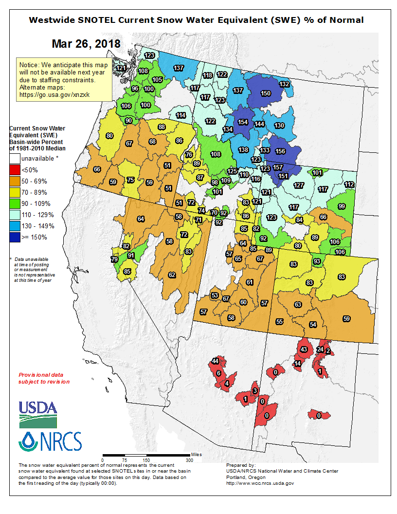
Colorado mountain snowpack still lags, at 72 percent of the norm, and federal forecasters project drought will persist across much of the southwestern United States, threatening agricultural producers.
Near-record low snow levels remained at 60 percent of the median or less Sunday in the southern half of Colorado in the Arkansas, Rio Grande, San Miguel, Animas, Dolores and San Juan river basins, the latest federal survey shows. In the northern half of Colorado, snowpack hovered around 84 percent of the median in the Upper Colorado River and South Platte River basins, data show.
Water utilities have been monitoring conditions closely since early January, counting on spring snow and relatively full reservoirs to supply residents during dry months this summer and fall…
Precipitation levels this past winter also have lagged around the state, with 83 percent of average precipitation in the Upper Colorado River basin, 61 percent in the Arkansas River basin and 54 percent along the Rio Grande, data show.
Farmers drawing water from McPhee Reservoir on the Dolores River are holding out hope for a full allocation this season.
Pleasant View-area farmer Travis Daves, who has 2,000 acres of irrigated farm land, plans to plant all 2,000 acres with alfalfa, corn and spring wheat.
He is aided by the fact that McPhee, at about half full, is higher than normal for this time of year thanks to generous runoff from the winter 2016-17 snowpack. McPhee holds 381,000 acre feet, of which 229,000 are its active capacity, the volume of water that can be used for irrigation.
Daves said if the small recent storms continue, farmers drawing water from McPhee will be all right. He’s expecting a full allocation of irrigation water, which is about 22 inches per acre…
In addition, he said the long-range forecast is for a shift in the jet stream, allowing more storms into the Four Corners during this stingy La Niña winter.
The outlook is less bright for those farming on the Florida Mesa and dependent on water from Lemon Reservoir.
Phil Craig, who has 130 acres he plants with hay on the Florida Mesa, said the snow-water equivalent for Lemon is at 45 percent of the 30-year average, and he expects only a half allocation of irrigation water this year, which will take him through June or perhaps the Fourth of July before he runs dry.
During a normal year, he has enough irrigated water to run through mid-September.
He’s planning for only one hay cutting this year, compared with three cuttings in a normal year…
Like McPhee, Lemon, which holds about 40,000 acre feet, is about half full, which Craig says is helpful because usually this time of year, Lemon is about one-third full.
Like Daves, Craig still holds out for the possibility the La Niña pattern will break down, offering generous April showers…
The Pine River Irrigation District, he said, is currently looking at about 80 percent of normal supply for irrigators.
Again, he said, the reason the allocation is that high is because of the bountiful spring 2017 runoff.
The major problem for irrigators will not be this year, but next year if Southwest Colorado gets two low snowpack years in succession, Harris said. He cited patterns in 2001 and 2002, the year of the Missionary Ridge Fire, and 2012 and 2013 as examples of back-to-back weak winters, with farmers able to muddle through subpar years in 2001 and 2012 only to be clobbered in 2002 and 2013 when irrigation rations were cut substantially…
The snowpack that will supply runoff to the San Miguel, Dolores, Animas and San Juan rivers is at 53 percent of normal.
“It’s very unlikely we will get anywhere near a 30-year average. At this point, it would be really, really hard to catch up to a 30-year average or a 100-year average or any kind of average,” Harris said.
Mike Preston, general manager of the Dolores Water Conservancy District, operator of McPhee Reservoir, said despite snowpack that is only slightly above 50 percent of the 30-year average, irrigators on the Dolores Project are sitting “right at the edge” of a full allocation.
Again, he credits the generous 2017 runoff that’s left McPhee storing about 50 percent of the water needed for this year’s growing season.
If regular storms return through April, Preston said people with water rights on the Dolores Project will get a full allocation for irrigation…
If the stingy season holds on through April, Preston said there’s a chance the full allocation might be reduced to 80 percent.
The latest inflow forecast for runoff into McPhee for the spring is for 110,000 acre feet – enough for a full allocation to irrigators…
McPhee needs about 1 inch of snow-water equivalent from a normal amount of storms through April to ensure a full allotment of water to irrigators, he said.
The storm that hit last weekend provided seven-tenths of an inch of snow-water equivalent.
Despite abnormally warm and dry conditions in the Pikes Peak region, Colorado Springs Utilities officials are not planning to impose restrictions on water usage this year.
The area has seen slightly more than half of the average precipitation so far this year and temperatures are nearly two degrees above normal to date, said Abigail Ortega, water resources manager. But Utilities has nearly three years worth of water on hand.
The 30 reservoirs providing water to Utilities average 81 percent of capacity, Ortega said.
Seasonal temperature outlook through June 30, 2018 via the CPC.
Seasonal precipitation outlook through June 30, 2018 via the CPC.
For starters, this spring is unique because this is an unusual second consecutive year of La Nina, which typically points to dry and warm conditions, although this doesn’t always materialize, as one or two big spring storms can really change the numbers. As climatologists and meteorologists offer up a few different forecasts and theories, here’s what’s on the table this spring for farmers and ranchers regarding expectations of moisture and temperatures…
“One thing that has made this La Nina interesting is that we are in our second straight year of La Nina. It’s not unheard of by any means, but we haven’t observed a particularly large number of second-year La Ninas either. The second year La Ninas we have seen tend to be cool and wet in the northwest and northeast corners of the country, and milder and drier everywhere else. The last one we saw was 2012,” said Peter Goble, research associate with the Colorado Climate Center on the campus of Colorado State University in Fort Collins…
The official spring outlook from the Climate Prediction Center for Colorado in April, May and June is an increased likelihood of above normal temperatures for eastern Colorado, with a greater likelihood to the south. “The southeast and central east plains have particularly dry soils right now down to 1-3 feet (think: south of Akron). The soil moisture is looking better out towards the northeast corner of the state,” Goble said adding, “Of course, the new CPC outlook (issued March 15) for April to June temperatures is based on more than just soil moisture, but you’ll notice the odds of a warmer than normal April/May/June are higher for southeast Colorado, than northeast Colorado.”
This official 90-Day outlook also indicates an increased chance of above average spring warmth from western Kansas into western Oklahoma. Then, for north central Kansas and eastern Kansas, there’s a slightly lower possibility of warmer than average spring temperatures. Southern Nebraska and much of Iowa have even lower chances for a warm spring, and in fact, have close to equal chances for either average, above or below average temps.
Further north, from the northern half of Nebraska into northwest Iowa, closer to normal spring temperatures are expected…
“Although a weak La Niña is expected to continue through the spring, the influence lessens as we move into summer. This can be seen in the latest three-month outlook for April-June, which has a neutral outlook for precipitation in most of Kansas,” said Mary Knapp, assistant state climatologist at Kansas State University, Department of Agronomy, Manhattan, Kan. “Even with normal precipitation, it would take some time to improve the current drought situation in the central and southern plains.”
[…]
“Wyoming often finds itself being in a transition area from north to south between the two. Not all La Ninas are the same and the strength of one has a major effect on the pattern produced. The current La Nina is also diminishing and conditions are heading toward ENSO-neutral (neither La Nina nor El Nino) probably in this April-June time-frame,” said Tony Bergantino, deputy director, Water Resources Data System – Wyoming State Climate Office and Wyoming CoCoRaHS State Coordinator. “Unfortunately, with Wyoming in the boundary area and with La Nina becoming quite weak now, signals can be mixed or indeterminate,” Bergantino said.
“Specifically for precipitation, while the odds favor the southern part of Wyoming (roughly the area south of a line running from the southern Yellowstone National Park down through the Laramie area) being drier than normal, the rest of the state north of that line has even chances for normal, above-normal or below-normal precipitation. Very much a similar situation occurs for temperatures with approximately the southern half to one-third of Wyoming having better chances for above-normal temperatures while the northern half to two-thirds of the state has no signal one way or the other,” Bergantino said. Regarding the April-June period for eastern Wyoming, Bergantino expects a greater chance of warmer temperatures in the southern third of Wyoming with the signal making a forecast indeterminate for the northern two-thirds. For precipitation in eastern Wyoming for that same period of time, drier than normal conditions are only slightly favored for a small part of the south, and unknown for everything north of that…
There’s a different theory from Nebraska Climatologist Al Dutcher, who said if the ongoing pattern of low-pressure systems continue to approach the central plains (northern Kansas and points north) and Midwest (upper Mississippi River valley, Great Lakes and Ohio River valley) these areas could see cool and active weather, should it continue.
“The last two upper lows (low pressure systems) produced respectable precipitation on the north and east side of these upper air lows. The south and west sides of these systems have been able to pull in the dry air from the southern plains (dry slot) and wrap it around these low pressure systems, effectively cutting off precipitation on these two flanks of the storm. Thus, even though parts of central Kansas are experiencing very welcome moisture, the western one-third of Kansas as well as Oklahoma and Texas received none to very light (less than a half-inch) of moisture,” said Dutcher, associate state climatologist for the Nebraska State Climate Office in Lincoln…
Meanwhile, Dutcher said snowpack continues to disappoint across the southern Rockies, with only very limited relief to no relief so far for the worst hit areas of the southern U.S. winter wheat belt.
“Snow recovery for the southern Rockies is highly unlikely, as we are near the statistical peak of their snowpack season. I expect complete melt out of the snowpack for New Mexico and the southern one-third of the Rockies before the end of May,” Dutcher said. “Temperatures are now reaching the 70s and 80s across the southern wheat belt and those temps also extend westward into the lower elevations of the southern Rockies. That’s the problem across the entire southern half of the Rockies, low snow at low elevations, normal to below normal snowpack at the highest elevations.” He expects low elevation snow values to melt out earlier and increase high elevation melt out quicker, instead of a buffering rapid melt out.
Dutcher said, as long as there’s normal moisture this spring, Nebraska could still escape significant drought implications. “If the central Rockies is to maintain normal snowpack through early May, it will translate into a very wet pattern for the west central corn belt (Kansas, Nebraska). This would also be supportive of severe weather, as upper air lows associated with this type of pattern eject from the southern Rockies, head northeast and develop storms on the north side of the warm front, as well as, along the cold front. These systems are usually responsible for our most significant tornado outbreaks,” Dutcher said.
The Climate Prediction Center outlook also shows that the Pacific Ocean is likely to return to neutral conditions during the March-May season, Goble said. “But it’s still more likely than normal that we’ll see a warm, dry spring. The eastern Plains have been very dry recently, and it’s easier for the sun to quickly warm dry soils than wet soils, so that’s another piece of the puzzle,” he said. “Seasonal forecasting is also more difficult than forecasting the weather tomorrow, so it doesn’t hurt to be ready for anything.”
Westwide SNOTEL basin-filled map March 26, 2018 via the NRCS.
Tucked away in the massive $1.3 trillion federal omnibus spending bill is a much-needed policy fix that ends the frustrating practice of “fire borrowing.”
Before the president signed the bill Friday, the cost of fighting catastrophic wildfires in the West was wreaking havoc with efforts to reduce the threat of fires in the first place.
Most federal agencies can draw from an emergency fund to pay for disaster response. But not the Forest Service and the Interior Department. With no access to disaster funds, they’ve been forced to borrow from other areas of their budgets, creating a destructive cycle of fighting megafires at the expense of programs that are supposed to mitigate fire risk.
This wildland fire funding problem affects Western states, so it’s no surprise that Colorado’s U.S. Sens. Michael Bennet and Cory Gardner were instrumental in forging a bipartisan coalition to include a fix in the spending bill.
The deal secured in the omnibus is based on the framework from Bennet and Gardner’s Wildfire Disaster Funding Act. It provides the Forest Service with certainty in its discretionary funding for programs other than firefighting so that more agency resources can be spent on management and restoration. It allows the Forest Service to “complete the entirety of its mission,” without being undermined by the pressures of fire, Bennet said…
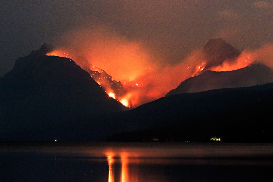
With costs exceeding $2.4 billion, the 2017 fire was season was the most expensive ever, according to the Forest Service’s Cost of Fire Operations program. Colorado’s anemic snowpack may contribute to an earlier and above-normal fire season, underscoring the need for a fire funding fix.
Sen. Dean Heller, R-Nev., filed the bill to reauthorize for four years the conservation program, first passed by Congress in 2015 to conserve water and mitigate impacts of drought in the Colorado River Basin…
Southern Nevada, which includes Clark County and Las Vegas, receives nearly 90 percent of its water supply from the Colorado River.
“Southern Nevada is no stranger to drought, and that’s why I continue to fight for policies that strengthen our state’s water supply and infrastructure,” Heller said in a statement.
Heller filed the bill on Tuesday.
A report by the U.S. Bureau of Reclamation in January projected that the level of Lake Mead, where Las Vegas draws its water, would be about 5 feet lower by the end of the year.
The surface of Lake Mead has fallen 131 feet since 2000.