New Study: #Snowpack levels show dramatic decline in western states –@OregonState

Linear trends in 1 Apr SWE relative to the starting value for the linear fit (i.e., the 1955 value for the best-fit line): (a) at 699 snow course locations in the western United States for the period 1955–2016, with negative trends shown by red circles and positive by blue circles; (b) from the simulation using the VIC hydrologic model for the period 1955–2014 (cells in gray have mean April 1 SWE less than 5 mm; areas in white are not simulated); (c) as in (b) but using temperature data in which linear trends have been removed for the 1954-2014 period. Lines on the maps divide the West into four regions for analysis shown in subsequent figures

Here’s the release from Oregon State University (Mark Floyd/Philip Mote):

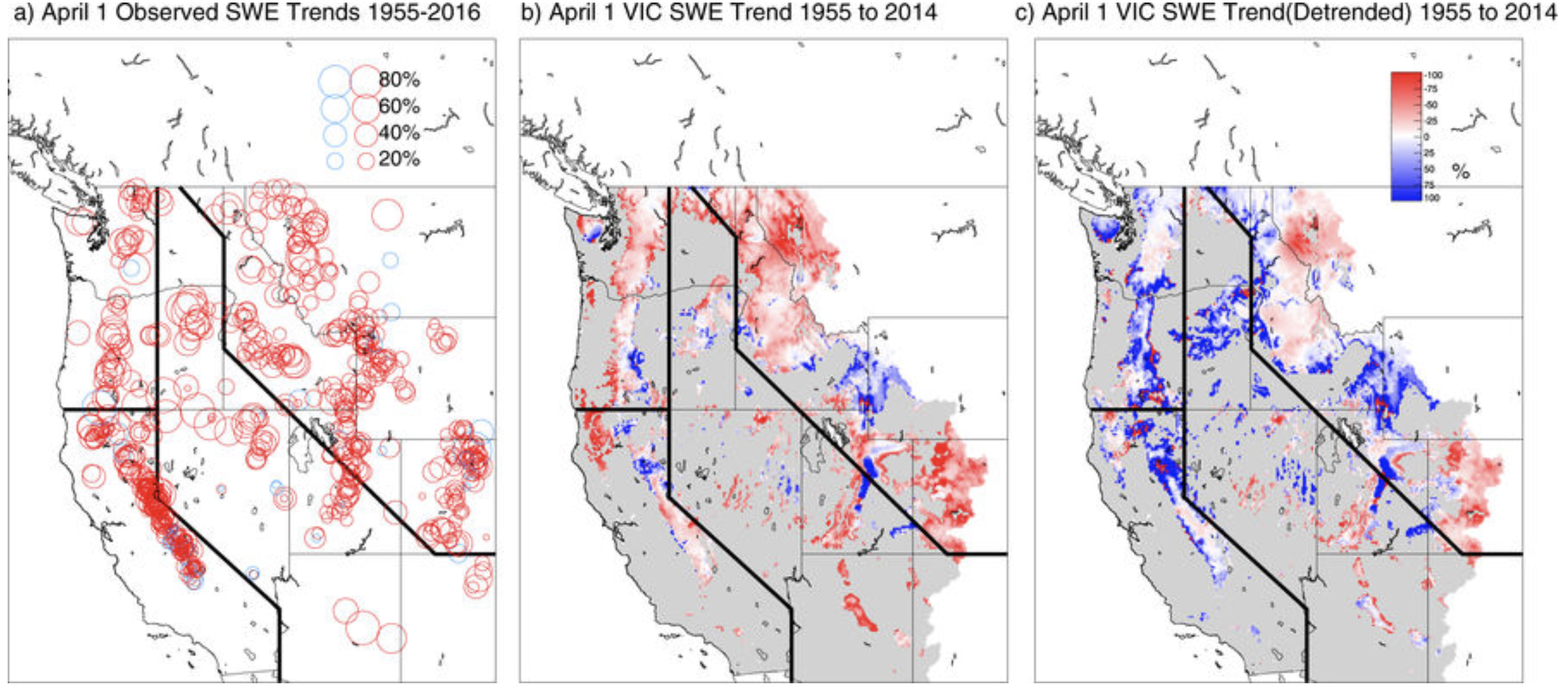
A new study of long-term snow monitoring sites in the western United States found declines in snowpack at more than 90 percent of those sites – and one-third of the declines were deemed significant.

Since 1915, the average snowpack in western states has declined by between 15 and 30 percent, the researchers say, and the amount of water lost from that snowpack reduction is comparable in volume to Lake Mead, the West’s largest manmade reservoir. The loss of water storage can have an impact on municipal, industrial and agricultural usage, as well as fish and other animals.

Results of the study are being published today in NPJ Climate and Atmospheric Science, a Nature publication.

“It is a bigger decline than we had expected,” said Philip Mote, director of the Oregon Climate Change Research Institute at Oregon State University and lead author on the study. “In many lower-elevation sites, what used to fall as snow is now rain. Upper elevations have not been affected nearly as much, but most states don’t have that much area at 7,000-plus feet.

“The solution isn’t in infrastructure. New reservoirs could not be built fast enough to offset the loss of snow storage – and we don’t have a lot of capacity left for that kind of storage. It comes down to managing what we have in the best possible ways.”

The researchers attribute the snowpack decline to warmer temperatures, not a lack of precipitation. But the consequences are still significant, they point out. Earlier spring-like weather means more of the precipitation will not be stored as long in the mountains, which can result in lower river and reservoir levels during late summer and early fall.

The study considered data from 1,766 sites in the western U.S., mostly from the U.S. Department of Agriculture’s Natural Resources Conservation Service and the California Department of Water Resources. The researchers focused on measurements taken on April 1, which historically has been the high point for snowpack in most areas, though they also looked at measurements for Jan. 1, Feb. 1, March 1, and May 1 – which led to the range of decline of 15 to 30 percent.

They also used a physically based computer model of the hydrologic cycle, which takes daily weather observations and computes the snow accumulation, melting, and runoff to estimate the total snowpack in the western U.S.

“We found declining trends in all months, states and climates,” Mote said, “but the impacts are the largest in the spring, in Pacific states, and in locations with mild winter climates.”

The Pacific states – California, Oregon and Washington – receive more precipitation because of the Pacific Ocean influence, and more of the snow falls at temperatures near freezing. Because the Cascade Mountains, which transect the region, are not as steep as the Rocky Mountains, they have more area that is affected by changes in temperature.

“When you raise the snow zone level 300 feet, it covers a much broader swath than it would in the inland states,” Mote said.

Mote was one of 12 lead authors on a chapter of the fifth Intergovernmental Panel on Climate Change report looking at the cryosphere, which is comprised of snow, river and lake ice, sea ice, glaciers, ice sheets and frozen ground. Also an author on the fourth IPCC report, he had led a 2005 study on western snowpack levels that had also documented declines that were less dramatic than those in this new study.

This latest study found:

  • California had the highest number of positive snowpack trends since 1955, but lingering drought during the past decade erased most of those gains and snowpack declines still dominated;
  • Most of the other western states had only one or two sites that reported increases in snowpack;
  • Regions with the most significant decrease in snowpack were eastern Oregon and northern Nevada, though snowpack decreases in excess of 70 percent also occurred in California, Montana, Washington, Idaho and Arizona.
  • “The amount of water in the snowpack of the western United States is roughly equivalent to all of the stored water in the largest reservoirs of those states,” Mote said. “We’ve pretty much spent a century building up those water supplies at the same time the natural supply of snowpack is dwindling.

    “On smaller reservoirs, the water supply can be replenished after one bad year. But a reservoir like Lake Mead takes four years of normal flows to fill; it still hasn’t recovered from the drought of the early 2000s.”

    Mote said snowpack levels in most of the western U.S. for 2017-18 thus far are lower than average – a function of continued warming temperatures and the presence of a La Niña event, which typically results in warmer and drier conditions in most southwestern states.

    The study was funded by the National Oceanic and Atmospheric Administration’s Regional Integrated Sciences and Assessment (RISA) program, and the U.S. Environmental Protection Agency’s Office of Atmospheric Programs.

    Mote is on the faculty of OSU’s College of Earth, Ocean, and Atmospheric Sciences. Other researchers on the study include Sihan Li, University of Oxford; and Dennis Lettenmaier, Mu Xiao, and Ruth Engel of the University of California, Los Angeles.

    Here’s the abstract from the paper:

    Abstract

    Mountain snowpack stores a significant quantity of water in the western US, accumulating during the wet season and melting during the dry summers and supplying much of the water used for irrigated agriculture, and municipal and industrial uses. Updating our earlier work published in 2005, we find that with 14 additional years of data, over 90% of snow monitoring sites with long records across the western US now show declines, of which 33% are significant (vs. 5% expected by chance) and 2% are significant and positive (vs. 5% expected by chance). Declining trends are observed across all months, states, and climates, but are largest in spring, in the Pacific states, and in locations with mild winter climate. We corroborate and extend these observations using a gridded hydrology model, which also allows a robust estimate of total western snowpack and its decline. We find a large increase in the fraction of locations that posted decreasing trends, and averaged across the western US, the decline in average April 1 snow water equivalent since mid-century is roughly 15–30% or 25–50 km3, comparable in volume to the West’s largest man-made reservoir, Lake Mead.

    Aaron Million’s latest project met with skepticism in #Wyoming

    The confluence of the Green and Yampa rivers in 2016. How much water reaches this point, bound for Lake Powell, has implications across the west and Colorado, and an ongoing water study might suggest how to manage water in a severe drought. Photo credit Brent Gardner-Smith.

    From The Wyoming Business Report (MJ Clark):

    Although Colorado has the right to develop its unused compact water, as does Wyoming, those involved in Wyoming water issues note that this project could result in major changes in how water is managed in the basin, since it changes how much water will be headed downstream from Flaming Gorge.

    The first time was expected to divert 250,000 acre-feet of water, and to cost $3 billion. After working with the Army Corps of Engineers on the project for two years, the Corps cancelled Million’s application in July of 2011.

    The second try

    Million immediately tried again and proposed tapping into the Green River at two sites – one just three miles below the city of Green River, Wyoming and the other from the western edge of the Flaming Gorge reservoir. Although the amount of water he wanted was the same, this time, Million quoted the cost as between $7 billion and $9 billion because he was adding a hydropower component to the plan. Thanks to the hydropower aspect, this new project would be under the authority of the Federal Energy Regulatory Commission (FERC).

    A Western Resource Advocates study on the second proposal predicted that not only would the water supplied by the pipeline cost up to ten times the price of water from other developments, it would also lower the level of the popular Flaming Gorge Reservoir by 10 feet – hurting fishing and tourist traffic in the Gorge, and river rafters along the Green and Colorado rivers by $58.5 million a year.

    A coalition of more than 250 businesses from seven states; ten conservation groups and Sweetwater County and the City of Laramie fought the development, along with Wyoming Governor Matt Mead, who wrote a letter to FERC that said in part, “”This project would cut a vast swath across southern Wyoming, with the potential for huge impacts in many significant sectors of our economy and aspects of critical resources to Wyoming and Colorado.” Mead also objected to the 25,000 acre-feet of water per year belonging to Wyoming that Million was including in his proposed ‘take.’

    When the FERC dismissed Million’s application as “premature” in February of 2012, Million was unfazed and told the Denver Post that, “The FERC dismissal has zero to do with us moving forward.”

    The third time

    In April of 2012, Million argued his case in a guest column for the Northern Colorado Business Report (at the time a sister paper to the Wyoming Business Report), claiming that less than 5 percent of the “massive Flaming Gorge Reservoir” would be pumped to Colorado’s Front Range annually. Meanwhile, it would help northern Colorado face its own water supply shortfalls.

    “If it is environmentally sound, it should be permitted and built,” Million wrote in the column, seemingly addressing the myriad environmental groups voicing fervent opposition to the pipeline. “If not, then stick a fork in it. The truth of a full scientific and environmental evaluation may be hard for some in the environmental community to swallow, but the consequences of not allowing that evaluation to occur remain.”

    As the Wyoming Business Report’s Mark Wilcox wrote at the time; “Aaron Million’s confidential business plan to annually pump about 81 billion gallons out of Flaming Gorge and the Green River that feeds it has been revealed to the Associated Press, and it is no small wonder he has not taken ‘no’ for an answer. The plan would bring in an estimated net profit of between $1.4 and $2.4 billion. And that’s after construction costs of somewhere between $2.8 billion and $3.2 billion. And end users of the water would pay up to $117 million in annual operating costs based on a ‘cost plus 20 percent’ business model with estimated operating costs of between $70 million and $90 million.”

    Million was granted a FERC hearing on his third proposal on April 23, 2012. Then his proposal was was rejected. “FERC’s ruling doesn’t affect us from the standpoint of continuing to move forward,” Million told the Wyoming Business Report at the time in a phone interview. However, the FERC denied him a re-hearing.

    “We are not persuaded by any of Wyco’s unsupported arguments that it should be issued a preliminary permit,” the commission said in its filing…

    Is the fourth time a charm?

    This January, Million was back with a new approach. This time, he started by petitioning Utah for the water rights. This approach – petitioning for water to export from Utah – was so unusual that the state didn’t even have a form to fill out for it.

    Rob Harris, senior staff attorney at Western Resource Advocates (whose Wyoming ties include a grandfather from Basin) notes that the problem with petitioning for water rights as an individual is that “All three states have an anti-speculation doctrine in our water rights laws. [Million] doesn’t actually stand in the shoes of any actual Colorado water users. It’s really basic stuff he’s running up against – it’s why this has floundered in the past, and will continue to flounder until he’s made contractural arrangement with people who he’s going to supply water to.”

    An examination of Million’s application with the state of Utah has the all eventual users of the water identified as “TBD.”

    Harris points to a previous case in which water from the Arkansas Valley was eyed for the Front Range. “The court said ‘No way! You don’t have any contracts.’ It would be one thing if it were a city doing this, but this is just a guy trying to make money.”

    In addition to the change at the start of the process, Million’s fourth try has a few key differences to the last ones. First, he’s moved the point of diversion 50 miles southeast into Utah, away from the Flaming Gorge Reservoir, which should be some relief to the Wyoming outdoor recreation industry – but less comfort to Colorado River rafters.

    Second, he’s reduced the amount of water he wants to take each year from 250,000 acre-feet to 55,000 acre-feet. “It’s less water than last time,” Harris admits, “but it’s still a heck of a lot. You could run a pretty good-sized city on 55,000 acre-feet a year.”

    Third, he’s changed the name of the company he’s operating from Wyoco Power and Water Inc. to Water Horse Resources LLC.

    “I think he’ll point to the tons of growth in the Front Range, and that there is a gap between known [water] supplies and what’s needed to meet the expected population growth,” Harris said. “But if you look at the really big players in water on the Front Range (Denver Water, Colorado Springs, Aurora, Northern Water Conservency District), they’re all pursuing alternative sources [not tapping into the Green River]. They are emphasising creative ways to conserve and share the local water supply.”

    I’m only a kid, I can’t do anything about climate change…. right? — @KHayhoe

    Here’s the latest in the Global Weirding series from Katherine Hayhoe:

    During the video Ms. Hayhoe mentions this website:

    http://greenschools.net

    The latest newsletter from the @COHighLineCanal is hot off the presses

    High Line Canal Regional Context map via the High Line Canal Conservancy

    Click here to read the newsletter. Here’s an excerpt:

    Framework Planning Open Houses

    The High Line Canal Conservancy has launched the second phase of significant planning for the High Line Canal, a beloved 71-mile regional trail. This multi-jurisdictional planning initiative follows on the heels of the Community Vision Plan completed in early 2017. This planning phase will focus on a Framework Plan – a multi-year implementation plan to ensure that the Canal reaches its greatest potential as an environmental, recreational, social, historic and economic asset. It will include complete plans for signage and wayfinding, as well as landscape guidelines for all 71 miles.

    The first phase of public open houses for the Framework Plan is in April. The open houses will include an existing conditions analysis, preliminary signage designs, and an opportunity for input on potential enhancement projects and project priorities. Continued support and engagement from the citizens of the region is vital to ensure the future of the Canal is reflective of the public vision. Come share your thoughts in April!

    Tuesday April 10th, 4:30-7:30 pm
    Goodson Recreation Center – 6315 S. University Boulevard

    Thursday April 26th, 4:30-7:30 pm
    Aurora Central Library – 14949 E. Alameda Parkway

    For more information, please visit http://www.highlinecanal.org/framework

    @CWCB_DNR: February 2018 #Drought Update

    Colorado Drought Monitor February 27, 2018.

    Click here to read the update from the Colorado Water Conservation Board and Colorado Division of Water Resources (Taryn Finnessey/Tracy Kosloff):

    2018 has started off warm and dry across most of the state with very few below average temperatures; and despite recent precipitation, it is unlikely that many basins in the southern half of the state will be able to reach average snow accumulation this season. 71 percent of the state is in some level of drought classification with 38 percent in moderate drought, 26 percent in severe drought and 8 percent classified as extremely dry. An additional 20 percent of the state is experiencing abnormally dry conditions. Mesa Verde National Park is currently experiencing the driest conditions on record (1923). Water providers are cautiously watching conditions but most have above average amounts of water in storage.

     As of February 21, statewide precipitation at SNOTEL sites is 70 percent of average, with all of the basins improving as a percent of normal compared to last month. The North and South Platte basins have experienced the highest levels of precipitation in the state, at 95 and 103 percent, respectively. Despite recent gains, southern basins such as the Southwest basins of the San Miguel, Dolores, Animas & San Juan, Rio Grande and Gunnison basins remain below normal precipitation at 42, 51 and 55 percent respectively. Conditions are also dry in the Arkansas Basin at 61 percent of average annual precipitation to-date. Several attendees pointed out a concerning lack of snow at foothill elevations in the Front Range.

     Statistical analyses indicate that it will be hard for the state as a whole to reach normal snowpack given current conditions; however this varies from basin to basin with southern basins significantly drier than those in the north.

     Reservoir storage statewide is at 115 percent of normal, with all basins above average. The Arkansas basin is reporting the highest average storage at 143 percent. The Gunnison basin has the lowest storage levels in the state at 104 percent of normal.

     Both the SWSI and stream flow forecasts are based on conditions as of February 1, before several storms provided moisture to high mountain elevations. SWSI values declined compared to January 1, especially in the southwestern and south central part of the state. Stream flow forecasts are largely below normal statewide.

     Water providers in attendance report their respective system storage levels are at or above average for this time of the year, but the lack of snowpack in concerning and being closely monitored. The majority of representation was from providers in the South Platte Basin, which is currently has the highest snowpack in the state.

     Short term forecasts show that temperatures will be more seasonal with a normal chance of precipitation, however longer term forecasts indicate increased likelihood of below average precipitation and above average temperatures.

     A weak La Niña remains in force for now, and forecasts indicate that warm and dry conditions are likely to persist through the spring. It is unclear what will happen during the summer months.

    Platte to Park Hill Project Phase 1 update

    Storm drain and open channel improvements between the East Rail Line (38th & Blake Station) and the South Platte River (Globeville Landing Outfall), Stormwater detention/conveyance between the East Rail Line (38th & Blake Station) and Colorado Blvd, (Montclair Basin)
    Stormwater detention/ conveyance immediately east of Colorado Blvd. (Park Hill Basin).

    From 9News.com (Cory Reppenhagen):

    Denver Public Works refers to that problem area as the Montclair basin. It is the largest basin in Denver at 9.5 square miles, that does not have a path for stormwater to get to the South Platte River.

    So they say that stormwater tends to pool in that area, and some of the worst flooding in the city steams from this spot. The solution, according to Denver Public Works, is to build the largest flood protection project that Denver has ever seen.

    The Platte to Park Hill Project, or P2P, is extremely progressive in its use of open channels, water quality features, and inclusion of community and recreational assets.

    A 9NEWS crew toured the nearly completed first phase of this plan, called the Globeville Landing Outfall Project, which Denver Public Works describes as a giant storm drain.

    The centerpiece of this project is a massive pipe that’s actually a 500-yard-long, 12 foot by 15 foot – a concrete box culvert…

    This project will protect those historic neighborhoods around the Denver Coliseum, like Elyria, Swansea, Cole, Whittier, Clayton, Skyland, and Five Points.

    Denver Public Works said it will not only handle the routine stormwater, that often floods those areas, but also the big 100-year events.

    “It’s those storms that are above an inch in an hour. Two inches, three inches in an hour, those are the ones we don’t have a system for, those are the ones that this system is really going to do a good job for us,” said Uhernik.

    A thunderstorm that covers all 155 square miles of Denver, with just 1 inch of rain, puts down 2.7 billion gallons of water, which is enough to fill about 67 million bathtubs…

    In this new project, the water will flow out of that culvert and into the open, where it will run through a new park and into the South Platte River, just along the west end of the Denver Coliseum parking lot.

    It’s a natural path restored.

    Denver Public Works says this drain will be ready to take on stormwater by this summer. The new city park will be completed in the spring of 2019.

    They plan to build similar drains downstream in the years to come.

    ‘Tales from the #ColoradoRiver’ features KUNC’s Luke Runyon March 7 #COriver

    Luke Runyon near Hoover Dam power plan February 2018 via Colorado State University.

    Here’s the release from Colorado State University:

    The Straayer Center for Public Service Leadership will host a lunch event called “Tales from the Colorado River” featuring KUNC’s Luke Runyon on Wednesday, March 7.

    The event, which is free and open to the public, will be held from noon to 1 p.m. in the Lory Student Center, Room 322.

    One of Colorado’s best storytellers, Runyon will discuss his new work focusing on water in Colorado and the major lessons he’s learned. Those include lessons regarding natural resources and public policy that are critical for students interested in careers in public service.

    The event is a BYO Brown Bag Lunch & Learn, and the presentation will include a question-and-answer session.

    Space is limited; RSVP to shoughte@colostate.edu.

    The Straayer Center for Public Service Leadership is based in the Department of Political Science, which is part of CSU’s College of Liberal Arts.