Click here to go to the US Drought Monitor website. Here’s an excerpt:
Summary
Generally moderate precipitation (up to 3 inches) fell on most of the Southeast, Lower Mississippi Valley, portions of the California and Oregon Coasts, and the higher elevations of northern California. Lesser amounts (0.6 to 1.0 inch) dampened the central Appalachians, the Tennessee Valley, portions of the northern Intermountain West and southern Rockies, and most other sections of California outside the interior valleys and arid southeastern areas. Meanwhile, little or no precipitation fell on a large swath encompassing most of the Plains, and negligible amounts were also recorded in parts of the Ohio and Mississippi Valleys north of the confluence, the central Rockies, the Great Basin, and the desert Southwest. This includes some of the nation’s most intensely impacted drought areas from the Four Corners states eastward into the south-central Great Plains…
High Plains
Drought persisted or worsened from Kansas, central Oklahoma, and eastern Texas westward into Colorado and New Mexico. Drought intensity was degraded in many areas, with Exceptional Drought (D4) introduced in a patch of northern Oklahoma east of the Panhandle. Extreme (D3) drought now covers a large swath across northeastern New Mexico, most of the Panhandle and adjacent areas in Texas, western Oklahoma, south-central and southwestern Kansas, and southeastern Colorado. The last 5 months have been intensely dry from southern Kansas and adjacent Colorado southward through western Oklahoma, parts of northeastern New Mexico, and the Texas Panhandle. Most of this area has recorded only 0.05 to a few tenths of an inch of precipitation since early October, and impacts have steadily intensified. Winter wheat is struggling to grow, even in irrigated fields, and many crops planted after the early October rains never germinated. According to the National Agricultural Statistics Service, a large proportion of the winter wheat crop in several states is in poor or very poor condition, including 74 percent of the crop in New Mexico, 72 percent in Oklahoma, 53 percent in both Kansas and Texas, and 27 percent in Colorado. In addition, significant proportions of several other crops in Oklahoma are in poor or very poor conditions, specifically 60 percent of canola, 59 percent of rye, and 54 percent of oats. Texas oats are also suffering from the dryness, with 38 percent in poor or very poor condition. 38 percent of Texas oats are in poor or very poor The lack of rain has been accompanied by low humidity and strong winds at times, enhancing wildfire danger and causing some soil erosion. Many ponds and reservoirs are low, and some shallow wells have dried up.
The Governor of Kansas declared a drought watch in northern and eastern counties, drought emergencies in south-central and southwest counties, and drought warnings in the remaining areas.
Farther north, dryness and drought eased somewhat in northeastern Montana and remained mostly unchanged farther east, though some D2 expansion was introduced in southwestern North Dakota.
The winter wheat crop here has been affected by the dryness, but not to the degree observed in the southern Plains. South Dakota reports32 percent of its crop in poor or very poor condition, as are 18 percent of the North Dakota winter wheat crop…
West
Outside the patches of moderate precipitation in California and adjacent Oregon, it was a dry week, with more than 0.5 inch of precipitation restricted to parts of Arizona and far southern Nevada. Recent precipitation has been sufficient to end abnormal dryness along part of the west-central California coast, but conditions persisted or intensified elsewhere. In Utah, D3 expanded to cover a sizeable chunk of the middle of the state, and D2 extended farther northward in northeastern areas. Dryness and drought in Oregon remained unchanged from last week, but the Governor of Oregon declared a drought emergency in Klamath County due to low snowpack, subnormal precipitation, diminished streamflows, and above-normal temperatures…
Looking Ahead
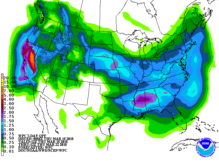
During March 15-19, 2018, most of the lower elevations in California expect moderate precipitation (0.5 to 1.5 inches). Another significant snow event is forecast in the Sierra Nevada, where precipitation totals may reach 5 inches. Elsewhere, generally moderate precipitation (0.5 to 1.5 inches) is expected across western Oregon and in broad area covering the southern Appalachians, central Gulf Coast States, Middle Mississippi Valley, central Plains, and central and northern Rockies. Amounts under 0.5 inch are expected elsewhere, with little or none falling in the desert Southwest, Upper Mississippi Valley, southern High Plains, south Texas, and Middle Atlantic States. Daily maximum temperatures should average above normal across the Southeast, the southern half of the Mississippi Valley, and the central and southern Plains. Daily average highs may average over 12 degrees F above normal across much of Kansas and Oklahoma and adjacent parts of Missouri and Arkansas. In contrast, days will stay cooler than normal through most of the Rockies and Far West, the northern Plains, and the Middle Atlantic States.
For the ensuing 5 days (March 20-24), odds favor above-normal precipitation over a large part of the contiguous states, including most areas from the Atlantic Seaboard westward to the Mississippi Valley, the northern Plains, and from the Rockies westward to the Pacific Coast. Enhanced chances for below-normal precipitation cover the central and southern Plains, most of the Florida Peninsula, and the southern rim of Alaska. Abnormally warm weather is favored in southern Florida, the west half of the Gulf Coast, most of Texas, the southern High Plains, and the southern Rockies. Most of the country farther west, north, and east should average cooler than normal, including southeastern Alaska.
The next week is shaping up OK for moisture for much of the Rockies (sorry SE Colorado and San Luis Valley).