From the Center for Snow and Avalanche Studies. Click through for the whole analysis. Here’s an excerpt:
SUMMARY
Colorado has begun March with low SWE conditions dominating most parts of the state. Only the Northern Front Range area and North Eastern Colorado has closer to average SWE conditions. This update summarizes snowpack conditions state-wide and evaluates March 1st snow water equivalent (SWE) data from SNOTEL stations associated with our eleven CODOS sites and places them within the framework of the Dust Enhanced Runoff Classification scheme (DERC) developed by CODOS. A summary is presented by individual Basin, and provides site-specific analyses for each CODOS site (linked at bottom of page).
SNOWPACK CONDITIONS
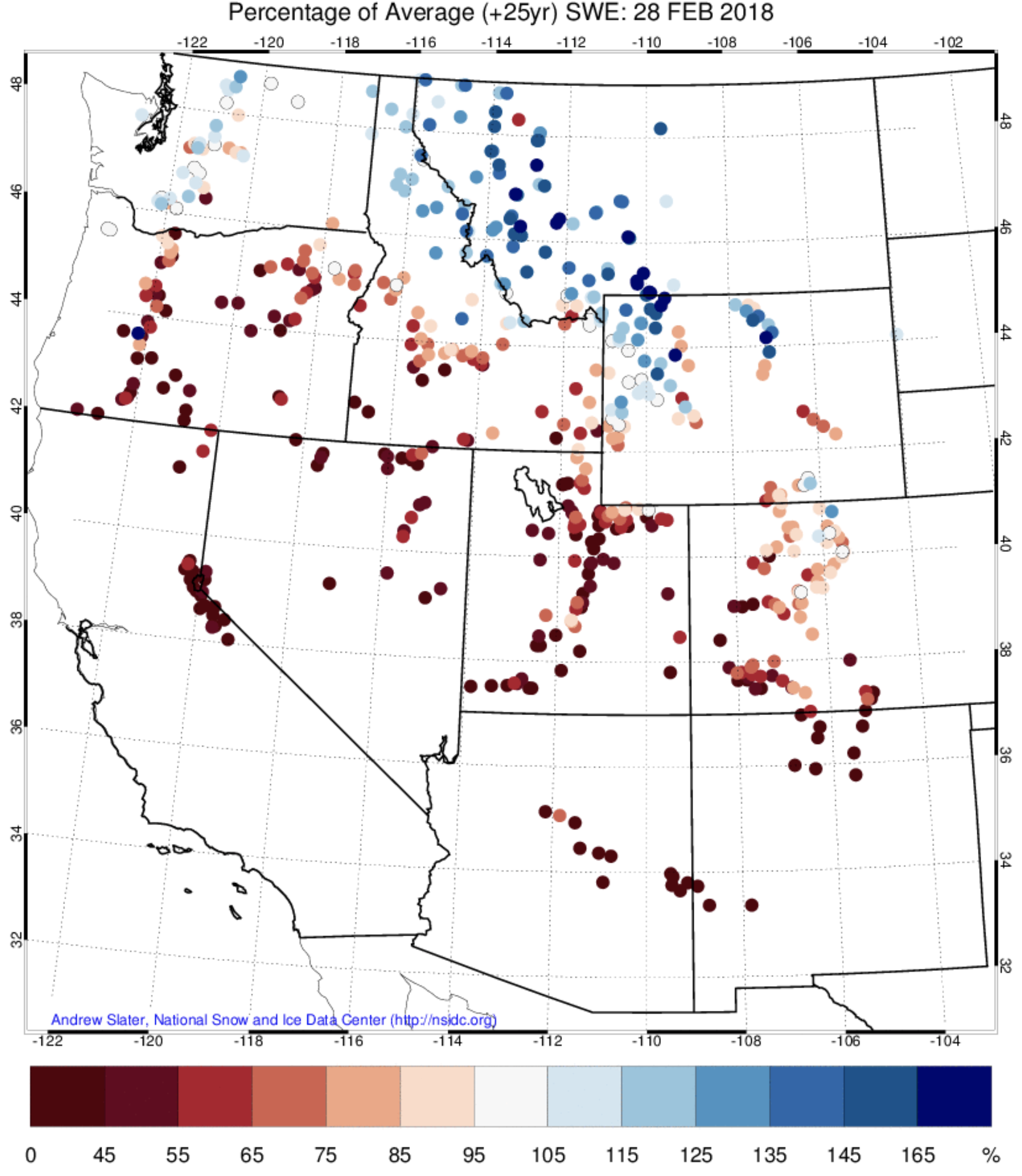
Snowpack conditions for this time of year are very low in many parts of the state. The average of the major basins’ percentage of median March 1st SWE is 74%. Individual SNOTEL station SWE throughout Colorado ranges from 21% at Grayback in the Rio Grande Basin to 131% at Buffalo Park in the Upper Colorado Basin. This winter’s drought is being felt in most parts of the Western United States, with the only major exception being the Northern Greater Yellowstone Ecosystem region of Montana, Idaho and Wyoming and parts of the Washington Cascades. Much of the Western US is seeing SWE conditions of less than half of median for this point in the year.
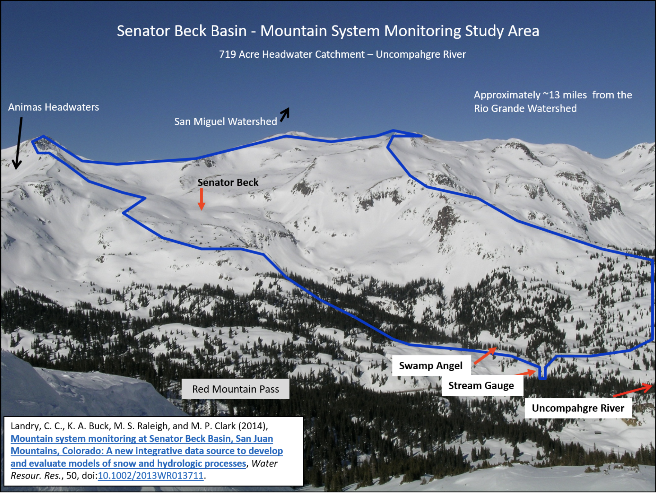
To augment SNOTEL data and better understand snowpack conditions it is important to consider data collected in Senator Beck Study Basin (SBSB). SBSB is located at, or near, the headwaters of four major watersheds (Animas, Uncompahgre, San Miguel, and Rio Grande) and is the only high alpine study site in the region collecting comprehensive snowpack information. Being a headwater study basin, the elevations that we collect snowpack information and continue meteorological station monitoring is well above the highest of most SNOTEL stations.
Senator Beck Study Basin location near Red Mountain Pass near Silverton, CO. Elevation of the Basin ranges from 11,030’ at the stream gauge to 13,510’ at the crest of the peaks. The blue line delineates watershed boundary. Senator Beck Study Plot and Swamp Angel Study Plot are the locations of highly instrumented meteorological stations and is also where snowpack data is collected. Credit: Center for Snow and Avalanche Studies
WINTER WEATHER SUMMARY: AN ABNORMAL PATTERN
The consistency of Northwest atmospheric flow during early part of winter lasting though January is responsible for the great disparity in snowfall across the West. For the majority of the winter there has been a stationary atmospheric ridge sitting over the west coast. This pattern is most prominent in the jet stream, a high elevation wind pattern which steers large scale weather systems like storms along it’s path. The resilient shape of the jet stream this winter has deflected and directed the majority of moisture-laden systems into a Northwest flow regime. This pattern heavily favors areas such as Montana while leaving California, Oregon, southern Idaho and Southwest US region high and dry. Here is a link to a great description about this “ridiculously resilient ridge” and it’s relationship to the historic fire season in California, and is very applicable to Colorado’s low snow year as well: http://weatherwest.com/archives/tag/ridiculously-resilient-ridge
El Niño Southern Oscillation (ENSO) has also contributed to this incredibly dry season as well. ENSO is a large-scale pattern in sea surface temperatures which has a major influence on weather in the Western Hemisphere. This coupled ocean-atmosphere phenomenon has been presenting moderate La Niña conditions this year, and some of the weather we have experienced over the winter can be linked to this pattern. La Niña conditions occur when cool sea surface temperatures dominate the equatorial region of the Pacific Ocean. It is typical of a La Niña year to see diminished snowfall and warm temperatures in the Four-Corners states and other regions of the Southwest US. We are now pleased to see ENSO conditions rapidly returning to neutral where they are expected to hover for the remainder of the winter. Hopefully this pattern shift will usher in additional spring precipitation so we can continue to build SWE in our basins through the spring.
Even with this ENSO pattern shift we are still expecting above average temperatures and below average precipitation through at least May. These long-term outlooks are rough estimates, but they are about as accurate as we can be at this point in predicting more long term climatological trends…
DUST-ON-SNOW AND DERC CLASSIFICATION
Over the course of our 2005-2018 period of rigorous observations, March 1st has marked the beginning of the heart of “dust-on-snow season” for the Colorado Mountains (see the CODOS Dust Log chart of dust events by month). So far for WY2018 at Senator Beck Basin, the primary ‘sentry site’ for the CODOS program, we have logged two dust events. The first of these only effected the early season snow and is now diffuse in the basal layers of the snowpack and will not have any hydrologic consequences. Our second event of the season came in on February 18th-19th and is a bit more than a meter off of the ground, meaning that once exposed this layer will impact melt rates in the spring. Currently this dust layer is hard to see due to its diffuse nature, but it may become more visible as settlement occurs, and once it coalesces at the surface it should be very visible. Unless conditions change, the CODOS team will do our first state-wide dust assessment of the season around March 19-23. We try to time our trips to best capture documenting dust in/on snow conditions, if there is plenty of fresh snow accumulation and minimal dust we delay the tour, but if we feel dust layers are near the snowpack surface we hit the road to determine the potential short-term and latter melt season impacts.
As of March 1st, Colorado SWE remains “low” among all major basins. DERC “Average” SWE equals day median +/- 10%, and deviation above and below those limits are assessed as having “high” or “low” SWE. The basins listed below are classified according to the appropriate DERC classification of either Low, Avg, or High March 1st SWE layer domains…
For individual SNOTEL stations associated with our eleven CODOS sites, March 1st SWE ranges from 48%-112% of median levels. March 1st SWE conditions were classified for the SNOTEL station directly associated with each CODOS site, and also for select nearby SNOTEL stations. Prior seasons with similar March 1st conditions were identified and placed within the appropriate dust enhanced March 1st SWE space. Local watershed hydrographs (from 2006-2017) associated with those March 1st SWE conditions are presented as plausible examples of runoff behavior in spring 2018, with the understanding that these prior years exhibit a limited variety of 2006-2017 dust and spring precipitation conditions for each CODOS site. Water forecasting in extreme years is particularly difficult. In this extreme dry year in most of Colorado many SNOTEL stations are reporting in the single digit percentile for their POR, the hydrographs included in the DERC classifications are worth reviewing to get an idea of what we could potentially be in for in terms of runoff behaviour. Many hydrographs in the DERC classification under low March 1 and dry spring conditions show peak streamflow upwards to a month earlier than the median for many watersheds.
Colorado River Basin in Colorado via the Colorado Geological Survey
FromThe Grand Junction Daily Sentinel (Dennis Webb):
The [Colorado River District], which includes Mesa County and 14 other counties and focuses on the protection, conservation, use and development of Colorado River water in western Colorado, long has been concerned about protecting the region’s agricultural sector. Now district staff are worried about a potential new threat to it, from investment companies buying water rights possibly as a speculative investment, and looking to profit later in deals that could lead to some local agricultural land no longer being irrigated and reverting to desert.
For the river district, the concern is keeping the Western Slope from eventually seeing the kind of widespread drying up of agricultural lands and withering of local farming and ranching economies that has occurred in areas of eastern Colorado over the decades as municipalities have bought up water rights.
District general counsel Peter Fleming addressed some of the acquisitions and their potentially speculative nature in a January memo to the board of the river district.
“For example, a New York hedge fund called Water Asset Management (through one of its many subsidiaries) acquired a 330-acre farm within the Grand Valley Project in mid-September 2017. While not a huge farm, that size is among the larger-sized parcels within the Grand Valley Project,” Fleming wrote in his memo, referring to the local Bureau of Reclamation irrigation project.
He told the board the farm’s associated historical consumption depends on numerous factors but could be about 840 acre-feet a year. An acre-foot is about 326,000 gallons.
That New York City company paid $3.83 million to Gary and Christi Flynn to acquire the farm located along 18 Road, well-known as the main access road to popular mountain bike trails on nearby federal lands.
In his memo, Fleming also cited a purchase by Boulder-based real estate investment and management company Conscience Bay Co. of western Colorado, including the 1,450-acre Harts Basin Ranch near Cedaredge in Delta County.
“To our knowledge, the properties continue to be operated as they have historically and there are no current plans to change the associated water rights or move the water off the land,” Fleming wrote. “However, it is clear that increasing water demands, reduced supply, and the potential risk of compact curtailment have put a more direct focus on West Slope irrigated agriculture. Stated another way, reality has caught up with our historical paranoia about the acquisition and potential dry-up of West Slope agricultural rights for speculative purposes.”
[…]
“While speculation in land and water rights is nothing new, the recent acquisitions appear to be keyed-in on acquisition of pre-compact water rights to hold for the present time but sell to the highest bidder during compact-curtailment/administration,” Fleming wrote.
Fleming said in an interview that in Colorado, senior, primarily agricultural water rights would have priority in the case of curtailment. That makes those water rights attractive to water users with junior rights, such as Front Range municipalities, which might be able to continue diversions under junior rights under a compact curtailment while sending water associated with a senior right downstream to make up for it.
Another concern for the river district is the prospect of financial agreements being made where the water isn’t used for irrigation but instead flows out of state, perhaps to be stored in Lake Powell and held in a buyer’s account should something such as a drought or compact curtailment occur.
DISTRICT, COMPANIES TALKING
Perhaps contributing to the river district’s concern is the fact that Water Asset Management’s website indicates that the investment vehicle it used in the Fruita acquisition primarily acquires water resources at agricultural value, with the intention of later reselling those resources to higher-value municipal, industrial and environmental consumers.
Water Asset Management didn’t return calls for comment for this story, and the Flynns declined to comment.
Conscience Bay representatives plan to meet with river district officials this month.
“I do think that we will be able to satisfy them that we’re not a threat. In fact, we’re going to be a partner with them in trying to help solve water problems,” said Eli Feldman, the company’s president.
Conscience Bay paid nearly $8 million last year to acquire not just the 1,450-acre ranch Fleming referred to in Fleming’s memo, but also adjacent acreage that resulted in a ranch 3,200 acres in size. Conscience Bay also has owned a 600-acre ranch in the Steamboat Springs area for about a decade, besides having commercial property investments.
“We’ve never sold any water to anybody,” Feldman said. “We’ve never done any (water) transfers of any nature, really.”
He said water is only a secondary interest for the company’s agricultural investments.
“Our primary interest in these ranches is their agricultural value and long-term food production,” he said.
He said the people at Conscience Bay are long-term investors, and the long-term appreciation of ranchland and farmland combined with the return on investment from ranching makes it a competitive investment compared to other options out there.
The river district’s new general manager, Andy Mueller, said the district is looking forward to its upcoming meeting with Conscience Bay representatives. He said district officials recently “had a good discussion” with representatives of Water Asset Management.
“I can say that they are actively acquiring properties in the Grand Valley,” Mueller said. “They also say they are primarily interested in them as working agricultural assets.”
He said the company expressed interest in participating in a voluntary, compensated temporary fallowing program.
Feldman said Conscience Bay likewise is interested in exploring things such as temporary fallowing that could free up some water for municipal, fishery, environmental or other uses. He believes such programs would provide agricultural operators some valuable income, especially in dry years when farming might be that much tougher. In times when agricultural commodity prices are low, it could help preserve ag land that might otherwise be subject to buying and drying to meet municipal needs.
“If you can add a new source of revenue for that (agricultural) community I think it would be fantastic and allow them to really hold out for the long haul,” Feldman said.
Fleming said it’s important that any such approach occur in a limited, measured way that protects collateral local economic interests such as sellers of fertilizer, trucks and farm implements, and that lands aren’t taken out of production for good.
For now, Mueller noted, while fallowing programs are being explored, none is in place on a permanent basis in the region.
“We want to make sure that (investment companies) have the information that indicates that the legal structure to engage in those kinds of behaviors does not exist today and it may not exist in the future, but it’s being studied,” he said.
He said the river district hopes to continue to be engaged with companies like Water Asset Management and Conscience Bay and emphasize the priority the district places on Western Slope agriculture.
“Frankly, we would like to study their financial models and their methods of operation to verify that the goal is really the long-term preservation of our agricultural communities,” he said.
He said the district is hoping to understand what makes the properties being acquired appear to be good investments from a water standpoint. He said a concern is that “investors who are not agricultural producers themselves may drive an economic model that would require a higher or faster return than a very limited fallowing program that may exist.”
WATER TIED TO LAND
Meanwhile, there’s a question as to what degree water investors could engage in activities such as being paid to let their water head downstream. Physically, Grand Valley water not consumed could flow across the state line, Mueller said.
“The question is, legally, does that model work? There are lots of reasons why it probably does not. That’s something that we’re looking at very closely,” he said.
Lots of considerations come into play, from local ditch company rules to state water law, under which not using the water could lead to potential abandonment of water rights, something the river district also doesn’t want to see happen, Mueller said.
Mesa County Commissioner John Justman said that if the buyers of the Flynn farm want to try to sell the water for use somewhere else, they face the fact that Grand Valley Project water rights stay with the land and can’t be sold separately.
“I don’t know that they did their homework,” Justman said.
Mark Harris, general manager of the Grand Valley Water Users Association, which operates part of the Grand Valley Project, said that while Grand Valley Project water rights can’t be sold apart from the land, the river district is nevertheless raising fair questions about things such as what latitude people might have to make deals involving not using water and letting it run downstream.
“We’re encouraged and are pleased that the river district is looking at this issue,” he said.
The users association has been involved with the river district and other entities in a pilot program to evaluate temporary, voluntary, financially compensated fallowing by farmers as a means of helping bank water in reservoirs in case of drought. Proponents want to ensure that if such an approach is pursued on a longer term, other forms of water conservation also are pursued that target other water users besides agriculture.
Harris said the users association is “certainly interested, in the face of increasing drought, in the pressure that’s going to be put on agricultural water throughout the West.”
He said any consideration of water demand management in an agricultural environment is something to which the association has to pay attention.
“People are trying to think about the future, knowing that it’s not going to look like the past and that some of the solutions we’ve looked at in the past aren’t going to fix the future,” Harris said.
The company last year bought the 1,450-acre Harts Basin Ranch south of Cedaredge, prompting the river district to wonder whether the purchase’s purpose was speculative, with the possible motive of looking to later profit on the ranch’s water rights in a manner that could mean drying up of agricultural land.
Feldman says the district need not be concerned (see main story) and that the principal reason for the investment is ranching.
Conscience Bay also bought additional adjacent acreage, resulting in a combined ranch size of 3,200 acres. Feldman said the ranch includes about 1,000 cows, and the company also has federal grazing permits in Colorado and Utah. Some six to 10 people run the ranch, which also includes a haying operation. Mark and Poly Hill, who have a ranching background in Grand County, are in charge of the ranch.
Conscience Bay is interested in joining in the discussion with the river district and others about concepts such as temporary fallowing to make water available for other needs in times such as droughts while keeping agricultural land from being permanently dried up. Feldman said his company has a strong conservation ethic. He now serves on the board of directors of the Western Resource Advocates conservation group, where he once worked, and he also enjoys outdoor activities like fishing and backcountry skiing.
Mike Higuera, who oversees the company’s investments in agricultural lands and its conservation work, previously was involved in land acquisition and conservation easement transactions for the Nature Conservancy.
The company is a Certified B Corporation, a certification that Higuera said is for companies that work to do good things for society beyond making a profit. The certification focuses on things such as how companies treat employees and give back to the community in ways such as charitable contributions.
The company is inviting the public to a meet-and-greet lunch at its recently acquired ranchland on March 17 in conjunction with Eckert Crane Days at Fruit Growers Reservoir, which is adjacent to the ranch. Directions to the ranch will be provided at the Black Canyon Audubon Society table at the festival.
It’s been many years since Gypsum faced a summer dry enough to warrant water restrictions. Gallegos noted that the town has made several improvements to its municipal water system since that time. It needed to, because Gypsum has also grown considerably over the past decade.
Gypsum Town Engineer Jim Hancock offered an overview of the Gypsum water system. The community currently has two treatment plants. The Norgaard Plant, located along Vicksburg Lane, is the town’s secondary plant, and the Mosher Plant, located south of the Brightwater development, is the town’s primary water-treatment facility. The source for the Mosher Plant is high-quality Mosher Spring…
Along with its treatment facilities, the town has storage capacity of 1,000 acre feet at Lede Reservoir. Hancock noted an expansion project at the Lede site was completed last summer to double its capacity. The town hopes to fill the reservoir this summer.
While the town has solid water sources, Gypsum wants to beef up its residential use education program.
“We want to let people know the connection between your lawn and the gutter,” Hancock said.
As Gypsum looks ahead to the summer, officials noted that typical winter municipal water use is around 1 million gallons per day. In the summer that jumps to 3.5 million gallons per day. They would like to keep that number under control if dry conditions continue.
DROUGHT PREPARATION
“The town plans for drought. Droughts occur,” said Kevin Patrick, Gypsum’s water attorney.
Patrick noted it wouldn’t be practical or financially feasible to plan a municipal water system to routinely meet drought year standards. Instead, towns and cities plan for normal conditions and then address drought needs through public participation in stricter restrictions. He noted that was the reason for the meeting — “to have everyone understand we are all in this together.”
Patrick praised past Gypsum water actions.
“Getting Lede was a coup,” he said, noting that it is unusual for towns as small as Gypsum to have such large storage capacity.
But Patrick added that on Feb. 1, snowpack readings for the Eagle River Basin were just 31 percent of normal.
“Now, we have had some snow, some rains since then,” he said. “We get 75 percent of our precipitation between Feb. 1 and April 15.”
Because slight weather pattern shifts can make a big difference in precipitation, Patrick said the Colorado high county could still avoid drought conditions this summer. However, the long-range forecasts aren’t very promising.
“So, what is the town going to do this summer if there is a drought?” Patrick said. “Part of today is to put it in everyone’s mind what they can and cannot do in their particular subdivisions.”
TOWN WATER WARNING
“Don’t use town water if you have a raw water system,” Patrick stressed. He then repeated that warning.
Several subdivisions in Gypsum — Cotton Ranch, Sky Legend, Chatfield Corners and Buckhorn Valley and more — have raw water systems in place for lawn irrigation. If residents run a hose to use treated municipal water for outdoor uses, then they are subject to fines. The penalties are $50 for a first occurrence, $200 for a second occurrence and $500 for each additional violation. Those charges will be added to individual water bills.
Using treated water for outdoor use in areas where non-potable systems are in service is just one violation that can generate a ticket when the town institutes Phase II or Phase III water restrictions. Phase II regulations mandate an alternating day schedule for lawn watering and irrigation hours before 9 a.m. and after 6 p.m. There are also restrictions about vehicle and equipment washing and other outdoor uses. If the town institutes Phase III regulations, then lawn irrigation and most outdoor uses are prohibited.
If the town institutes water restrictions, then the announcement will be posted on the town’s website by 9 a.m. the Wednesday after a regularly scheduled Gypsum Town Council meeting. Those meetings happen on the second and fourth Tuesdays of the month.
“The way we are going to get the word out is, first and foremost, it is your responsibility to check our website,” Gallegos said.
Because communication is a critical element of Gypsum’s water plan, Gallegos said that the water summit was the first step to reach out to residents about the town’s water rules. She noted Gypsum has compiled a lot of water information, everything from a comprehensive list of subdivisions served by raw water systems, to a list of voluntary and mandatory restrictions to information about drought surcharge fees.
About 50 people attended last week’s session, but Gallegos noted that the water summit information also is available online at http://www.townofgypsum.com.
Andrea Clark, Tom Kirkpatrick and Dana Black allege that Powderhorn bought a 1-cubic-foot-per-second winter water right that didn’t totally belong to the person who sold it to the resort. They also allege that removing more water from Mesa Creek in the winter will harm the other water users and worsen problems with the creek icing over, and that the ski resort can’t put the water it purchased to beneficial use at this time and bought the water rights on speculation.
The plaintiffs claim that Powderhorn should not be able to change the use of water it purchased from the Mesa Creek Ditch, which was formerly used during the winter for domestic and livestock purposes. The resort purchased the water from former Mesa Creek Ditch Association board president George Bevan.
According to court documents, Powderhorn intends to divert a maximum of 150 acre-feet of water during the winter, transport it to the H.U. Robbins Reservoir and store it there until it uses the water for making snow. The reservoir has a decreed capacity of a little more than 100 acre-feet of water and is located more than a mile from Mesa Creek, its source, according to state water records.
However, the plaintiffs allege that Powderhorn’s intent to use the water isn’t good enough — that the state’s requirement for water rights to be put to beneficial use should be applied here. In other words, they claim Powderhorn’s purchase of the water with no infrastructure for transporting it to its reservoir was speculative, which is not a legal use under Colorado law for those water rights. They also claim the resort’s reservoir needs significant repairs and has not been used for nearly 40 years, and that the resort hasn’t proved it can or will be able to transport or store the water.
Powderhorn’s attorneys claim the resort already proved the change in the water rights wouldn’t hurt any of the other water users and that Bevan owned and used the water he sold the resort for decades.
They also plan on calling Andy Daly, co-owner of Powderhorn, to testify that the water rights are necessary to have a reliable water source for snowmaking. This comes during a winter in which the resort didn’t open until the week before Christmas, snowpack levels are dismal and Powderhorn limited its operating days for weeks to keep its runs open with snow made by the resort.
Daly also plans on telling the court that Powderhorn will find one way or another to transport the water the 1.19 miles from Mesa Creek to its reservoir, though it does not have a way to do so currently, according to court documents.
“As for landowner access, Powderhorn can purchase, lease, or condemn the rights of way necessary to convey the subject water right to the ski mountain and H.U. Robbins Reservoir,” said the brief filed by the ski resort’s attorney, Glenn Porzak.
Other parties in the case include the Colorado Division of Water Resources and Ute Water Conservancy District, the largest domestic water provider in the Grand Valley. Ute Water became involved in the matter before the ski resort purchased the water in 2016, according to an agreement between the two entities that was signed by Ute’s board president at the time.
In the agreement, Ute Water agreed to not oppose Powderhorn’s application asking the state for permission to change the water right’s specified use to snowmaking. In exchange, Powderhorn offered shares of stock in the Mesa Creek Reservoir and Canal Co. and also said it would ask the state to let Ute Water have water that it bypassed and didn’t divert for snowmaking.
The plaintiffs are represented by Clark’s husband, attorney Jim French, who is handling the case pro-bono, and Isaiah Quigley, a Grand Junction attorney.